THE THREE AKYEM: A COMMUNITY PARK FOR THE TOWN OF AKYEM ODA, GHANA ALEXANDER NAGEL. (Under the Direction of Pratt Cassity) ABSTRACT
|
|
|
- Juliana James
- 5 years ago
- Views:
Transcription
1 THE THREE AKYEM: A COMMUNITY PARK FOR THE TOWN OF AKYEM ODA, GHANA by ALEXANDER NAGEL (Under the Direction of Pratt Cassity) ABSTRACT This thesis presents a program and design for a new community park for Akyem Oda, a small town in the rain forest region of Ghana. The town was visited two times in 2004 and 2005 as part of the ongoing yearly Summer Service-Learning Studio during which time a site inventory was performed. Background research for the program development included geography and history of Ghana with a special focus on the Asante kingdom, traditional building techniques, land planning and an exploration of Akyem history in relationship to the dominant kingdom of Asante. A photo documentation of the main features of Akyem Oda and their spatial relationships to each other completes the research part of this thesis. The program for the proposed Three Akyem Community Park integrates a Parade Ground, a Cultural Center and three Groves representing each of the three Akyem people on the 8.9 acres rectilinear site. INDEX WORDS: Africa, Akyem Oda, Architecture, Asante, Cultural Center, Community Park, Courtyard House, Diaspora, Ghana, Grove, Land Planning, Parade Ground, Service-Learning, Tourism
2 THE THREE AKYEM: A COMMUNITY PARK FOR THE TOWN OF AKYEM ODA, GHANA by ALEXANDER NAGEL Diploma, Tuebingen University, Germany, 1996 M.S., The University of Georgia, 2003 A Thesis Submitted to the Graduate Faculty of The University of Georgia in Partial Fulfillment of the Requirements for the Degree MASTER OF LANDSCAPE ARCHITECTURE ATHENS, GEORGIA 2007
3 2007 Alexander Nagel All Rights Reserved
4 THE THREE AKYEM: A COMMUNITY PARK FOR THE TOWN OF AKYEM ODA, GHANA by ALEXANDER NAGEL Major Professor: Committee: Pratt Cassity Mary Anne Akers Karim Traore Jennifer Perissi Electronic Version Approved: Maureen Grasso Dean of the Graduate School The University of Georgia May 2007
5 ACKNOWLEDGEMENTS There are many people who in different ways helped me along the way towards completion of my program and this thesis. I feel deeply grateful to all of them. I want to thank my committee for their time and patience. I want to thank The Peachtree Garden Club of Atlanta for generously awarding me the Neel Reid Graduate Scholarship in 2005, which made it possible to visit Ghana for that year s Summer Service-Learning Studio. This thesis couldn t have happened without their support. I want to thank The Garden Club of Georgia for supporting me during the scarce years of Graduate School. I want to thank my classmates for many great discussions and much valued feedback, especially Ben Liverman, Martha Reynolds, Jennifer Britton and Lindsey Mann. I want to thank Frank Busumtwi and Ismaela Ibrahim Alhaji for their hospitality and help that opened many doors. I want to thank the people of Akyem Oda for their warm welcome and a truly life-changing time in their town. I hope I could return just a fraction of what I received. I want to thank Pratt Cassity for many opportunities, encouragement and a lot of laughter. I want to thank my parents for always believing in me. And, I want to thank my wife Dawn for making life beautiful. iv
6 TABLE OF CONTENTS ACKNOWLEDGEMENTS... iv CHAPTER 1 INTRODUCTION GEOGRAPHY OF GHANA HISTORY OF GHANA THE AKYEM AND THE FOUNDING OF ODA ARCHITECTURE AND LAND PLANNING IN ASANTE A TOUR OF AKYEM ODA THE THREE AKYEM PARK...70 Existing Conditions...70 Program Development...72 Design Presentation CONCLUSIONS...97 REFERENCES v
7 CHAPTER 1 INTRODUCTION This thesis presents plans and recommendations for a new community park for Akyem Oda, a small town in the rain forest region of Ghana. This city is undergoing major changes, as traditional building techniques and forms are abandoned; so far this very provincial town, missing from the travel schedules of most tourists, now attempts to attract more visitors. Internet and mobile phones are available and major plans for restructuring the core of the city are underway. Summer Service-Learning Programs have been conducted in Ghana for several years, but 2004 was the first year it was done in Akyem Oda. The fourth Summer Service-Learning Program in Oda is planned for summer Akyem Oda was personally visited as part of the Summer Service-Learning Studios in 2004 and A total of approximately two months was spent in this town with additional weeks dedicated to travel that explored other parts of Ghana including Lake Volta, the coastal towns of Cape Coast and Elmina, the Ghanaian capital Accra, Kumasi - the former capital of the Asante Kingdom, as well as the dry savannah regions of the North. The Ghanaian host Frank Busumtwi made his family house in a traditional part of Akyem Oda (Old Town) available to Service-Learning participants, which provided direct exposure to everyday life and culture in an African town. The studio included work in erosion 1
8 problems, streetscape improvements, park design and development of tourism infrastructure. During the second stay in summer 2005, local officials expressed need for the redevelopment of a narrow rectangular site covering approximately 8.9 acres located in an area called New Town into a park that would reflect local history and provide amenities and services required by the community. This thesis will do that as a design and policy component of the community s planning process. To achieve this goal, literature research of Ghanaian history, geography and culture were performed, rare maps were acquired from various sources nationwide and personal observations analyzed for usefulness to the task. Chapters 2 and 3 of this thesis set the stage by providing some basic facts about the geography and history of Ghana with special attention to the Southern regions. Chapter 4 presents results from research about the Akyem people and the circumstances that lead to the founding of Akyem Oda. Chapter 5 looks at traditional Asante architecture and land planning patterns, which concludes the literature review section of this thesis. Chapter 6 presents personal observations of the town of Akyem Oda via a photo essay. Locations of photos taken during both summers are keyed in a city map to make spatial relationships visible. The site of the proposed park is highlighted. Finally, Chapter 7 presents the site analysis, a concept for redevelopment based on results from previous Chapters that is used successively to develop a design for the site. Developing countries are in a compromising position. While there is money available for projects conserving historic structures, improving local economies and implementing necessary infrastructures, the application process requires the submission of project proposals and plans that require investments of money that local communities simply do not have. Academic Service-Learning projects help Ghanaian communities make positive changes, providing the 2
9 creation of plans, recommendations and reports for low to no costs to them. These plans then can be used to apply for funding. Successful projects hosted by the Office for Public Service and Outreach at the School of Environmental Design (SED), University of Georgia (UGA) have been conducted in several Ghanaian cities including Accra, Cape Coast and Akyem Oda. This thesis contributes to this process by providing a site design solution for one of them. Plans can help to get the process of community improvement initiated. 3
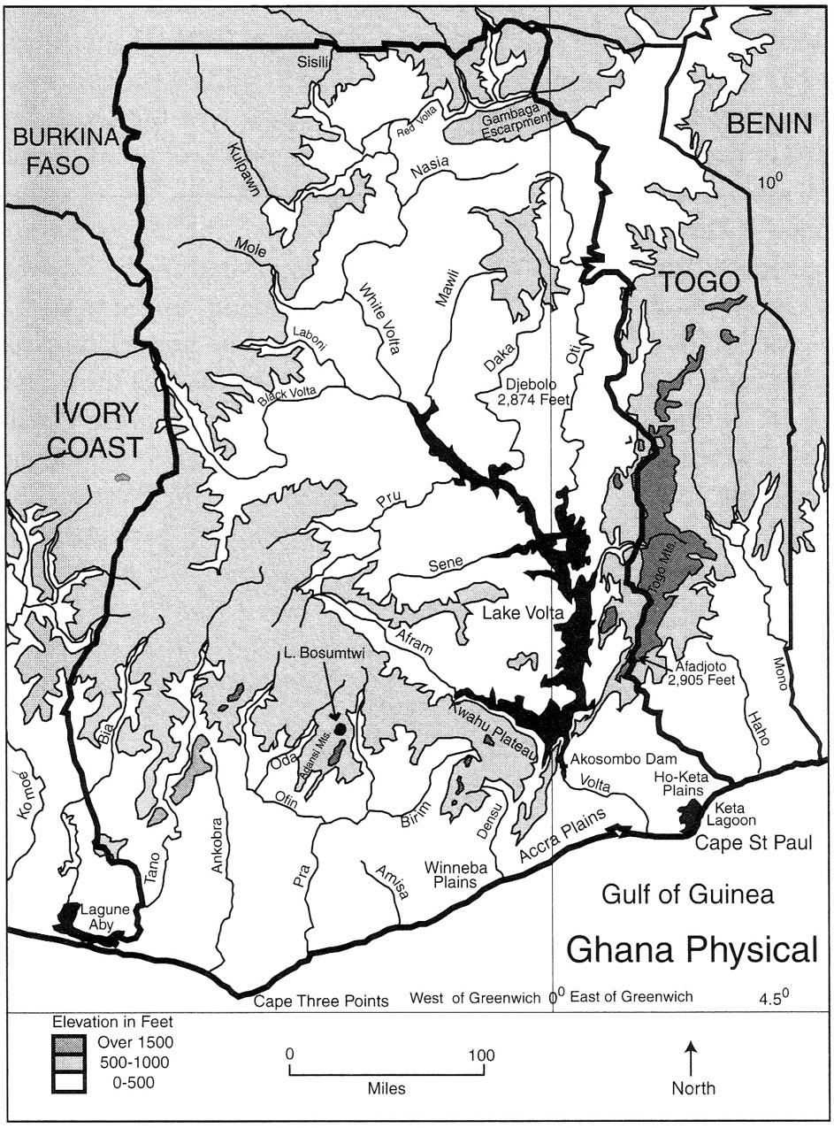
10 CHAPTER 2 GEOGRAPHY OF GHANA Ghana is located in the tropical region of West Africa, just 4.5 degrees North of the Equator and extends to a latitude of around 11 degrees North, which translates to a distance in North-South direction of approximately 420 miles. Other countries sharing latitudes with Ghana are Columbia, Venezuela and the Guyanas in South America, as well as Sri Lanka, Thailand and the Philippines in South-East Asia. The meridian of Greenwich (London) runs through Ghana at Tema, a port city East of the capital Accra. The extent in East-West direction is around 334 miles (Boateng 1966). The total area is roughly 92,000 square miles, which is slightly larger than the United Kingdom and slightly smaller than the state of Oregon. In comparison the state of Georgia in the Southern United States is 58,910 square miles. Ghana s neighboring countries are Ivory Coast to the West, Burkina Faso to the North and Togo to the East. Total population size as of 2004 is estimated to be 20.8 million, which makes it the second largest West African country after Nigeria. The capital and largest city Accra located at the coast has around 3 million people (Gocking 2005). Other important cities are Cape-Coast and Secondi at the coast, Kumasi in the rainforest, and Tamale and Bolgatanga in the North. The two major rivers are the White and the Black Volta, both originate in Burkina Faso and feed into Lake Volta (figure 2.1). The Black Volta forms the border to neighboring Ivory 4
11 Coast before it turns East. Lake Volta is the result of the construction of a dam at Akosombo, initiated in 1961 and completed in 1966, to produce electricity. About 80,000 people had to be resettled for this project. The lake is about 240 miles long, covers one sixth of the whole of Ghana and is the world largest artificial lake. Eventually a second dam was build downstream of Akosombo enabling Ghana to produce a surplus of electricity that it sells to neighboring countries. In addition to the production of electricity, the lake is an important inland transportation route for carrying passengers and goods from or to the North, it also provides water for irrigation and increased the inland fish yield significantly. The mouth of the Volta is at Ada, which is located East of Accra (Dickson, Benneh et al. 1988; Carmichael 1993). Other important rivers are the Pra, Ankobra and Tano (figure 2.1). All have their sources in the rainforest and run in a North-South direction towards the Gulf of Guinea. They can be navigated by canoes or smaller boats but rapids and waterfalls prevent the use of larger boats or vessels over long stretches (Dickson, Benneh et al. 1988). This is due to the geological character of Africa, whose coastal zones are very narrow, compared with other regions of the world, and are separated from the highlands by steep descents. Therefore rivers often have rapids and waterfalls close to the coast making water transport between the sea and inland difficult (Carmichael 1993). Ghana doesn t have any real highlands or mountains. There are several plateaus or uplands whose highest elevations reach less than 2,900 feet. The Akwapim-Togo ranges straddle the border to Togo in the East. The Asante Uplands and the Kwahu Plateau are located in the South-Western part of Ghana, in the rainforest, and run in a Southeastern Northwestern direction. Otherwise Ghana s terrain consists of flat open areas or rolling hills (Gocking 2005). 5
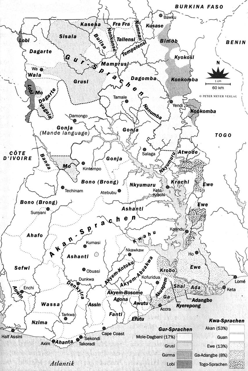
12 There are several different vegetation types throughout Ghana. In the South there is the coastal scrub and grassland formation. Directly at the coast there are sandy beaches fringed with coconut and other palms. The ocean all along the coast is rough with strong currents. The South-West and Central-South region is made up of rainforest that extends to almost half of Ghana in Northern direction. Some more rainforest can be found in the small region of the Akwapim-Togo ranges at the Eastern border. The remaining Northerly part of Ghana is covered by savanna. Politically Ghana is divided into ten administrative regions: Greater Accra, Asante, Western, Central, Eastern, Volta, Brong-Ahafo, Upper West, Upper East, Northern. The four main ethnic groups are: The Akan people speaking Twi-Fante language are located in the South- West of Ghana (Brong-Ahafo, Asante, Western, Central and Eastern regions). They include the Akwamu, Akwapim, Akyem, Asante, Bono, Fanti, Kwahu and others (figure 2.2). The Ga- Adangbe are located in the Greater Accra region, the Mole-Dagban in the Upper West, Upper East and Northern regions, and the Ewe in the Volta region (Farrar 1996; Naylor 2000). This study focuses on the Akan people, especially the Akyem, because they inhabit the region where the proposed park is located. The population is very young as is the case for other African countries: 37.1% (0-14 years), 59.1% (15-64 years), 3.7% (65 years and over). The median age is years and life expectancy years. Christianity is practiced by the majority of Ghanaians (63%). Other religions are Islam (16%) and indigenous beliefs (21%) (CIA 2006). The country is rich in natural resources: Gold, timber, industrial diamonds, bauxite, manganese, fish, rubber, hydropower, petroleum, silver, salt and limestone. Diamonds are found along the Birim river in the Akyem region, where several mines are established contributing 6
13 largely to the local economy (figure 2.2). Agricultural products (35.5% of GDP) are cocoa, rice, coffee, cassava (tapioca), peanuts, corn, shea nuts, bananas and timber. Industries (25.6% of GDP) are mining, lumbering, light manufacturing, aluminum smelting, food processing, cement and small commercial ship building. The third economical sector is services (39% of GDP), which includes tourism (CIA 2006). The three major export products are gold, timber and cocoa. The year 2005 saw the largest cocoa crop to date, which sold at record high prices. Subsistence agriculture is still a very important part of the economy (34% of GDP) employing 60% of the workforce mainly on small farms, where yam, cassava, plantain, rice, maize, millet, guinea corn, beans, groundnuts, tomatoes, onions, okra, pepper, garden eggs (eggplant) and spinach are grown (Naylor 2000; CIA 2006). Tourism is a growing industry in Ghana with the government investing much and expecting it to become the main source of export money by 2010 based on current growth rates (Salm and Falola 2002). Along the coast hotels and resorts offer beachside vacation packages while several of the restored castles in Elmina, Cape Coast and Accra are visited by tourists interested in the history and culture of the country. The African diaspora is especially interested in visiting Ghana in search of cultural and ethnic connection. West Africa, and therefore Ghana was the main region from where many enslaved Africans were carried to the Americas. Events as the Pan-African Historical Theatre Festival and Emancipation Day Ceremonies are designed to especially attract visitors with West-African associations. The government of Ghana announced plans recently to attract descendants of Africans back to their homeland by offering a special life-time visa and by relaxing requirements for receiving Ghanaian passports. The hope is that more diasporans come to visit, invest, study and even retire here (Polgreen ). 7
14 Figure 2.1: Ghana physical (Gocking 2005) 8
15 9
16 Figure 2.2: Languages of Ghana (Cobbinah 2002) 10
17 11
18 CHAPTER 3 HISTORY OF GHANA When the Gold Coast became the first fully independent African colony on March 6, 1957 its founding fathers chose the name Ghana after the famed West-African empire. The ancient kingdom of Ghana had been located between the Senegal and the Niger rivers in present day Mali and was one of the first West African kingdoms. It had its origin in the fourth century A.D. and attained the height of its power around 1000 A.D. Ancient Ghana controlled the sub- Saharan nodes of the trans-saharan salt and gold trade in a network that connected tropical Africa with North Africa, Europe and the Middle East. By collecting taxes on gold and salt that passed its borders, ancient Ghana was able to amass fabulous riches that allowed the empire to maintain a strong army, a powerful court and a sophisticated administration. Around 1235 A.D. after a period of struggle with internal problems and external attacks the empire was finally overrun and ceased (Carmichael 1993; Falola 2002). The victorious people established the empire of Mali, which would become equally rich and famous by controlling the trade routes. Its borders, extending beyond the ones of ancient Ghana, now included the gold fields to the South. That way Mali not only controlled the trade but also the production of gold. The famous King Mansa Musa made a pilgrimage to Mecca after converting to Islam. Around 80,000 attendants carried enormous amounts of gold that he 12
19 gave away freely on his journey through the Sahara and Egypt. It was reported that the amounts must have been so large that the value of gold dropped significantly after his visit in Egypt. He brought Islamic scholars and architects back home, who helped him establish a university in Timbuktu and introduce Islamic education. Ancient Mali collapsed by the end of the 14 th century after a series of internal problems and rebellions by several provinces could not be overcome (Carmichael 1993; Niane 1995; Falola 2002). Another great kingdom was established in the region that had previously seen the empires of Ghana and Mali. It was the Songhay kingdom and it had the largest area of the three West African empires. Similarly it derived its wealth from controlling the gold fields and trade routes and by selling captives from its wars of expansion as slaves, who were then transported to Egypt, Turkey and areas in South-West Asia. Songhay came to an end when it got defeated by the Moroccan army in 1591 (Carmichael 1993; Falola 2002). There has been some dispute about the connection of these ancient empires, especially the Ghana kingdom, to present day Ghana (Farrar 1996). To be sure none of these empires included the area of present day Ghana. Some authors claimed that the Akan, the largest ethnic group of present day Ghana, are immigrants from the ancient empire of Ghana and point out several similarities in culture, customs, beliefs and language between the Akan people and ancient Ghana in the North (Carmichael 1993; Gocking 2005). While it is a fact that there have been waves of migration, others emphasize that present day Ghana was inhabited for around 50,000 years, which means since Homo sapiens emerged, and that these early populations gave rise to the later people (Anquandah 1982; Carmichael 1993; Farrar 1996). The Kintampo culture appeared as early as 10,000 B.C. (Gocking 2005). Excavations have shown that this culture was located in the savanna as well as the rainforest regions covering a large part of present day 13
20 Ghana. Whatever their origin or several origins (Farrar 1996) the Akan which include the Akwamu, Akwapim, Akyem, Asante, Bono, Fanti and Kwahu, are historically and culturally the most influential and significant group in present day Ghana. The Asante would eventually control all the area of present day Ghana at the height of its empire at the beginning of the 19 th century. The Portugese were the first Europeans, who in 1482 arrived at a coastal stretch of West Africa that would later be called Gold Coast. The output of gold mines in Europe had declined, which together with other reasons resulted in an economic crisis. African gold had been sold to European markets via Arabian traders for decades. Now, European explorers decided to search for the sources of African gold themselves. Upon arrival the Portuguese built a castle at Elmina meant to be a safe trading station for centuries to come. Other European nations soon followed building castles on the shores of the Gold Coast. The castles in Cape Coast, Elmina and Accra are now restored as World Heritage Sites and are major tourist attractions. A total of 11 castles in Ghana are on the World Heritage Sites list. The ownership of the castles changed hands frequently before England gained absolute sovereignty of Gold Coast as its colony by the end of the 19 th century. Prior to that the Europeans were only interested in trade for gold and very soon slaves, and didn t interfere too much in local politics (Carmichael 1993). While trading slaves had been practiced throughout Africa for a long time, as mentioned earlier regarding the Songhay empire, it gained a whole new dimension shortly after Columbus discovery of the Americas in The peculiar economies of the newly discovered world demanded a huge number of laborers that could be provided by slaves brought from Africa s coast in the West. These dynamics produced the triangular trade in which ships would leave England with manufactured goods trading them in Africa for slaves who were brought to the 14
21 Americas, mainly the Caribbean and South America, and sold there. Agricultural products from the Americas were then transported to England completing the circle. The transatlantic slave trade brought an estimated 12 million imprisoned Africans to the Americas over a course of 350 years. This doesn t include those who were killed during raids, imprisonment in castles in Africa or by inhuman conditions on the ships. The trade had a huge impact on the population of Africa with an estimated 20% of the continent s population being removed by the slave trade. The trade disrupted communities and destroyed nations. Today, this would be the equivalent of 60 million Americans being removed from the United States. Not only European nations were involved and benefited from the slave trade, African empires and kingdoms did as well. The Asante kingdom was so heavily invested in the trading of slaves, besides its other major export gold, that it faced economic constraints when the slave trade was abolished in 1807 by the British Empire (Carmichael 1993). The Asante kingdom rose to power during the late 17 th century, when various Akan clans settled in the Kumasi region, the heartland of the coming empire (figure 3.1). The most famous king of the Asante was Osei Tutu ( ?), who is considered to be the legendary founder of the nation. During a stay with the Akwamu clan, which was friendly towards the Asante, he met the priest Okomfo Anokye who would be crucial in laying the spiritual foundation of the Asante kingdom. When Osei Tutu returned to Kumasi to become the king of Kumasi, the Kumasihene, Okomfo Anokye was with him to arrange the ceremony through which the different Asante clans were consolidated into one kingdom. The word for a chief or ruler is Ohene with the O being dropped when it is added to the name of a clan or people. According to history Okomfo Anokye planted the sacred Kumnini tree, whose growth was announced to be linked to the prospering of the king and he presented the Golden Stool to the new king. The 15
22 symbol of kingship for the Akan people is a wooden stool, with each clan having their own king as head. The Golden Stool was created by the priest to represent the ultimate power of the new king that stands above all the other enstooled kings thus in effect making him the king not only of Kumasi, but of the Asante, Osei Tutu had become the Asantehene and Kumasi the capital of his kingdom. Legend has it that during the ceremony the high priest Okomfo Anokye lifted his arms towards the sky upon which the Golden Stool appeared, which after its descend from the heavens would land on the knees of Osei Tutu. The Golden Stool is said to contain the soul of the Asante people and was never used as a throne. The king never sat on the Golden Stool but had it displayed close by. When the British finally conquered the Asante and entered Kumasi they were completely ignorant about their culture and their spiritual traditions. In an attempt to emphasize their power an officer in charge at the end of the 19 th century demanded the Golden Stool as a seat, which was taken as a severe offense and sparked renewed fightings (Carmichael 1993; Owusu-Ansah 2005). During his reign Osei Tutu increased his kingdom in several wars of expansion. Due to a very strong military tradition they defeated neighboring clans, including the Denkyira, to become the most powerful Akan nation. The Denkyira had established trading relations with the Dutch that now were overtaken by the Asante. The British main trading partners were the Fante with whom the Asante had hostile relations. This situation would later bring the British and the Asante into direct conflict. One of the clans the Asante tried to conquer were the Akyem. In a campaign against Akyem Kotoku the first Asantehene Osei Tutu was killed at the river Pra. His grandnephew Opoku Ware (~ ) became the next Asantehene and continued the expansion of the empire and eventually defeated the Akyem as well as the Sefwi, Aowin, Gonja, Dagomba, Techiman and Gyaman, but never the Fante and Wassa. By the end of his rule the 16
23 Asante kingdom was larger than present day Ghana, extending into areas that are now located in the neighboring countries of Togo and Ivory Coast (figure 3.1) (Carmichael 1993; Owusu-Ansah 2005). The fact that the Fante were never included in the Asante kingdom made their area at the coast a destination for fugitives trying to flee from Asante rule in the North. This brought them into conflict with the British who were the main trading partner of the Fante. In 1806 two Assin chiefs, who had lead a rebellion against the Asante, fled into Fante territory and asked for help from the British. They granted them protection causing a major attack on Fort Anomabu by the offended Asante, who put so much pressure on the besieged fort that they finally handed over the rebellious chiefs. This was one of the first encounters of the British with the military power of the Asante and the beginning of a series of military engagements that would mark the 19 th century. This hundred-year war saw the Asante in more than one battle gain victory, the only army in West-Africa to do so, until the final battle in 1900 was won by the British bringing all of the Gold Coast provinces under their rule (Carmichael 1993; Edgerton 1995). In 1869, three European missionaries were captured and kept as prisoners in Kumasi by the Asantehene Kofi Kari Kari. This was one of the factors that brought the British to prepare for a march and attack on Kumasi. After heavy fighting and turning fortunes British troops entered Kumasi in They found the missionaries in good health, but the king, his court and the main army had left the city and taken the Golden Stool with them. The royal palace was raided - the umbrella of state, the king s symbol of power, was later presented to the Queen of England and Kumasi including the palace burnt to the ground. In the aftermath of his defeat Kofi Kari Kari was destooled commencing a time of internal struggles for the leadership of the nation and tribal feuds. In 1888, the Asante Queen Mother s son Prempeh was enstooled as heir- 17
24 apparent and became Asanthene in The British tried to bring the Asante under their protection which Asantehene Prempeh had been able to prevent for some time. Finally, in 1896, troops entered Kumasi a second time; this time without encountering any resistance and required the King and Queen Mother to make a formal submission. After that they were led away into exile to the Seychelles, via Elmina and Sierra Leone, for 25 years. This time nothing of major value could be found in the palace and the city, everything including the Golden Stool had been removed for safe-keeping. The sacred Kumnini tree that had stood for 200 years was cut down and its stump and roots burnt, destroying the sacred grove around it. Other sacred sites had been destroyed as well (Carmichael 1993). A fort was constructed in Kumasi and British officials began to search for the Golden Stool. In one instance the sacred stool was demanded from the assembled Asante leaders. Why am I not sitting on the Golden Stool at this moment? the British official in charge of the search asked completely ignorant about the meaning of this sacred object. This was too much offense for the Asante and they organized an uprising under the leadership of the elderly Queen Mother Yaa Asantewaa. Fighting broke out in the spring of The fort in Kumasi was put under siege for several months before new troops arrived that would retake the fort in summer and finally defeat the Asante in fall. Leaders of the resistance together with Yaa Asantewaa were exiled to the Seychelles. The Golden Stool was never found, it came out of its hiding place much later when it was safe. In 1925 Prempeh was allowed to return from his exile in the Seychelles and assume his role as Kumasihene. Only Prempeh II, his successor, was finally granted the official title of Asantehene again in 1935 (Carmichael 1993). The Gold Coast was proclaimed a British crown colony in 1874, even though, the British did not have absolute control over all of Gold Coast until the Asante were finally defeated in 18
25 1900. Ghanaian nationalism started to develop as early as 1868 when representatives of the Fante, Denkyira, Wassa, Assin and Twifo agreed to form a confederation that would have military, governance and financial authority. The Constitution of the Fante Confederacy was signed in 1871 in Mankesim, but it never could be enacted because the British opposed it and had many of its creators put into prison. Several of them would later be essential forces in the movement towards independence (Carmichael 1993; Owusu-Ansah 2005). The charismatic leader and visionary who finally led the Gold Coast to independence was Kwame Nkrumah ( ). He had been to college in England and the US and received degrees in economics, sociology, theology and philosophy. In 1947 he returned to the Gold Coast and became chairman of the newly formed Convention People s Party (CPP) in The party promoted civil disobedience, strikes, boycotts and non-cooperation for which Nkrumah was sentenced to three years in prison. He was released after one year when his party won a major victory in a crucial election and his supporters demanded him being set free. Nkrumah never saw independence for Ghana as different from the freedom struggles of other African nations. His Pan-Africanism proclaimed the unity of all African nations and during his life he worked together with leaders of other parts of Africa towards common strategies and policies. For him, the first step in freeing and transforming the whole continent was achieving independence for the former Gold Coast on March 6, 1957 (Carmichael 1993; Owusu-Ansah 2005). In 1960 the Republic of Ghana was established with Nkrumah as its first president. The CPP under his governance increasingly undermined democratic principles, which instilled fears that Ghana was on its move towards dictatorship. In 1966 a military coup changed the power structure while Nkrumah was out of the country. He spend the rest of his life in exile and died in 19
26 in Romania in Ghana went through tumultuous years of changing governments, several military coups, dictatorship, and four separate republics, which was similar to other African countries during post-colonial reconstruction. However Ghana never experienced the extreme humanitarian crises and civil wars that destroyed the economies and people of so many nations on the continent (Owusu-Ansah 2005). The current constitution of the fourth republic was ratified in It guarantees free elections and voting rights for everybody above 18 years, freedom of speech and press and equal rights before the law. The National Democratic Congress (NDC) won the majority in the 200 seat parliament and Jerry John Rawlings (1947-) became president. His party governed for two legislature periods until it lost elections in 2000 to the New Patriotic Party (NPP) under John Agyekum Kufuor (1938-), who was reelected in 2004 and is the current president of Ghana (Cobbinah 2002; Owusu-Ansah 2005). 20
27 Figure 3.1: The Asante Empire (Gocking 2005) 21
28 22
29 CHAPTER 4 THE AKYEM AND THE FOUNDING OF ODA The Akyem or alternatively Akim and Achim are one of the major Akan groups of Ghana (figure 4.1). The word Akyem means salt trader indicating an important role of this profession for the economy of the original state. At some point, they were also actively involved in the gold and slave trades. Their economy had four main sectors: agriculture, hunting, gold-digging with varying intensities, and long-distance trading. According to Akyem tradition their origin as a state goes back to the 16 th century. In the 17 th century they have been forced by the Denkyira people to move eastwards into the area of the Birim River and the Atewa Hills further to the East. The Denkyira formed the most powerful Akan state with control over the majority of the gold trade with the Europeans before the rise of the Asante. Present day Akyem region covers only a fraction of what it used to be during the sixteenth and seventeenth centuries when it was described as one of the few big inland states. Today it makes up approximately one half of the the Western part of the Eastern Administrative Region of Ghana with around 3,200 square miles. It is located in the rainforest belt of Ghana, is mostly flat in character but also has some hill ranges, part of the Kwawu mountains, the Atewa-Atwiredu hills and the Akyem Peak (Affrifah 2000; Owusu-Ansah 2005). The Akyem were described as being among the few people who didn t fear the powerful states of the Akwamu, Denkyira and later the Asante. A British officer commented in 1868 that 23
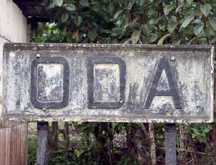
30 the Akyem were the only people who could successfully challenge the Asante when their kingdom was at the height of its power. Another British official observed that of all the states Akyem are the most allied by kindred to the Ashantees and at the same time the most bitterly hostile to them. Akyem and Asante were engaged in a series of conflicts and wars since the Asante defeated the Denkyira, then the most powerful state in This is mainly because the Akyem were intent on establishing powerful states, which would dominate their neighbors, or at least preserve their independence and territorial integrity. Another goal of the Akyem states was full and unimpeded trade with the Europeans at the coast. That, among other benefits, provided them with firearms necessary for the expansion or defense of their territory. Hostile relations lasted for 174 years ending only in 1875 when periods of independent sovereignty from the Asante changed with periods when the Akyem were under Asante rule. These conflicts were of much concern to the Europeans at the coast because it interfered with trading operations. The Akyem must be considered an important factor in the history of Ghana (Affrifah 2000). The Akyem have three major divisions, the Akyem Abuakwa, the Akyem Kotoku and the Akyem Bosome (figure 4.1). Akyem Abuakwa is the northernmost and largest division. Their capital is Kibi since around 1815, which is located in the Atewa hills. Akyem Kotoku is the middle division with Akyem Oda at the Birim River as their capital. Akyem Bosome is the southernmost and smallest of the three Akyems and has Akyem Swedru as their capital, which is less than three miles South from Oda (Cobbinah 2002; Owusu-Ansah 2005). Tensions leading to military exchanges were not restricted to relations with neighboring states but also occurred between Akyem divisions. The war in 1860 between the Abuakwa and the Kotoku, the two biggest divisions, eventually led to the founding of a new town, Akyem Oda. The roots of this war go back to the 1820s when the Kotoku emigrated from their ancestral home 24
31 due to pressure from the Asante and sought refuge in Abuakwa territory in Eastern Akyem. The Kotoku stayed put in this situation even though the relationship was an uneasy one. Eventually tensions erupted into outright war in 1860 causing the Kotoku leadership to migrate to Western Akyem where they were received as guests in the Bosome capital Akyem Swedru. The chief, the Bosomehene, a woman at that time helped the Kotoku leaders to apply for land with a neighboring chieftaincy that was readily granted to them. The Kotoku ruler founded a new capital on the acquired land in 1863 which he called Nsuaem, The Slice. The name was changed to Oda in 1922 to end confusion with a similar sounding town in the region. Migration and transplanting of people due to conflicts, wars and changing allegiances was very frequent producing a patchwork pattern of people from different ethnic origins living close together leading to situations where neighboring villages of less than 10 miles distance from each other speak different languages (Affrifah 2000). Today Akyem Oda located at the Birim River (figure 4.2) is the commercial and administrative center as well as district capital of the Birim South District that has an area of about 420 square miles with approximately 150 settlements most of them small hamlets (ruralurban split is 58:42). The Birim South District is located in the South-Western most corner of the Eastern Region with a population of 187,722 (2002 census) while Oda has a population of 38,741 (2000 census). Socially Birim South District is made up of mostly Kotoku traditional areas (60%) while Abuakwa and Bosome traditional areas equally share the remaining 40%. The vegetation can be characterized as semi-deciduous forest that consists of tall trees like the economically important Mahogany and evergreen undergrowth. The region has two rainy seasons with a peak during April-June and another one during September-November. The average temperature ranges from 77 o F to 82 o F and relative humidity from 55-70%. Oda lies 25
32 along a railway line that connects the terminus town Kade roughly 22 miles North-East of Oda to the Accra-Takoradi railway line around 8 miles South-West of Oda. This short railway sidetrack is not serviced anymore while the Accra-Takoradi line transports agricultural produce. There are plans to reestablish railway service through Oda within the next 5-10 years (Owusu-Ansah 2005; Birim-South-District-Assembly after 2002). More than 50% of the Birim South District s population is engaged in agriculture which is mainly subsistence farming. The majority of farms (58%) is under 7.5 acres. These farms produce food crops like cassava, maize, rice, plantain, groundnut (peanut), garden eggs (eggplant), cocoyam, tomatoes, onions, okra, and peppers for local consumption. Farms of more than 7.5 acres also produce cash crops like cocoa, citrus and oil palm. The main livestock production is fish and poultry farming. Infrastructure for processing citrus, and oil palm exist. Other industries are soap production, sawmilling, furniture production and diamond mining. Oda lies within one of Ghana s most important diamond producing region, where large amounts of mainly industrial diamonds are produced along the Birim River (Owusu-Ansah 2005; Birim- South-District-Assembly after 2002). Finally tourists are attracted to the Big Tree claimed to be the biggest tree in West Africa with 39 feet in circumference and 218 feet of height. A peculiar feature is that the trunk has constant circumference throughout its length. Other attractions are various events in the region. Each of the three traditional areas, the Kotoku, the Bosome and the Abuakwa celebrate a festival during the winter months of December through January. The Kotoku festival is known as Odwira. The activities include rituals for the ancestors, traditional drumming, dancing, dramas and the telling of stories that celebrate Akyem roots. The District Assembly would like to increase tourism to the region by attracting more visitors to the festivals. There is a need for 26
33 more lodging and a new marketing strategy. The African Diaspora has a big interest in researching their origins. The festivals together with improved information on culture, history and traditions could meet their needs and invite more to visit the Birim South District. (Birim- South-District-Assembly after 2002). 27
34 Figure 4.1: Modern Ghana showing the area of the Akyems (Affrifah 2000) 28
35 29
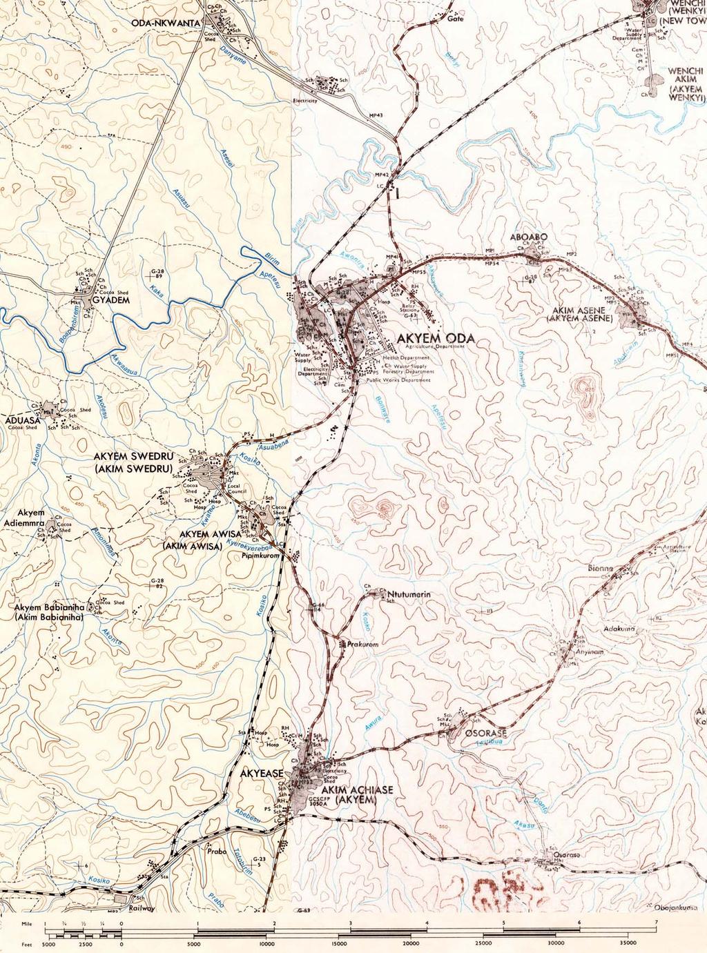
36 Figure 4.2: Map of Akyem Oda region (Survey of Ghana 1972) 30
37 31
38 CHAPTER 5 ARCHITECTURE AND LAND PLANNING IN ASANTE The following Chapter relies heavily on an article by Andrew F. Rutter published in Shelter in Africa (1976), edited by Paul Oliver. In the Asante region of Ghana a particular type of architecture had evolved as response to the natural environment and social customs. The typical courtyard form was developed during the time of the Asante kingdom. It underwent several changes during the following decades due to economical and political influences and can still be found throughout the region especially in villages and small towns (figure 5.1). More recently a modern type of building, the bungalow, is becoming increasingly popular due to changes in the way of living and building everywhere (Oliver 1976). Reports by 19 th century travelers to the Asante capitol Kumasi describe a city whose streets are very broad and clean with many trees that provide shade. There were three major building types. The ordinary house had one courtyard (figure 5.1), if it was large, up to four. The king s palace had around twelve courtyards each detailed differently (figure 5.2). The house that contained the shrine of a god was decorated with animal motifs on the outside and had two courtyards, one for the public ceremonies and the other for the priests. The ceremonial courtyard 32
39 was enclosed by four open rooms; the shrine room, one room for the singers, one for the drummers and the kitchen. The basic house (figure 5.1) had four open-sided rooms (patos) enclosing a courtyard (gyaase). The rooms didn t connect to each other at their corners but left gaps that were closed with screens and walls. In one of the corners the screen was placed so that a washing place was created between two adjacent rooms. All of the rooms were completely open towards the courtyard, only the major bedroom had a wall with a central opening towards the interior. One of the rooms was used for cooking, another for storage. The courtyard was entered through an unobtrusively placed door located at a side of the house. The walls had a core of bamboo-lattice (wattle) that was plastered with clay. The finish and decoration of the lower and upper walls was different creating a distinct base all around the house. The pitched roofs were thatched with palm leaves. The defeat of the Asante kingdom by the end of the 19 th century, the building of a railway in 1903, connecting the coast with the inland regions, as well as the construction of roads, initiated changes in the Asante communities including architecture. For the first time it was possible to introduce manufactured goods like sheet metal and cement that would replace locally produced building materials. The evolution of the Asante house is shown in figure 5.3. The rectangular courtyard form is the element that characterizes the Asante house and was retained throughout the times of kingdom, colonialism and independence. The most striking change from the 19 th century to the 20 th century is that the building now encloses the corners resulting in one continuous structure. Other changes are additional rooms, interior windows and doors, an interior raised veranda open towards the courtyard, an external raised balcony, and as mentioned earlier the use of new building materials. Elements that remained in place is the graduation of 33
40 spaces from public (street), through semi-public (just outside of the house, e.g. doorstops), semiprivate (courtyard) to private (bedrooms) and the location of the entrance unobtrusively to the side. The traditional building material is earth that is dug up, mixed with water and formed into balls. These are stacked upon each other to form a low segment of wall which is left to dry before the next segment is added on top. No foundation is used. With the introduction of new building materials houses are constructed with a concrete strip foundation and cement blocks. Compound houses belonging to families of the same clan are usually organized adjacent to each other on either side of the main road running centrally through a village. Figure 5.4 shows a plan view of the village of Old Kwamo which is located around eight miles East of Kumasi. The chief s house is located in the center of the village, close to the meeting place, shops and cemetery. Shops and food sellers are located along the main road. Latrines and refuse pits can be reached by short footpaths at the edges of the village. Their layout allows access from every house without need of using the main street. Some crops are grown in the outer areas of the settlement but most of the crops are grown on the farmlands that can be reached by several footpaths. There exists a clear sequencing of spaces along a public to private gradient. The main street with its through traffic, kiosks, traders and public buildings is the most public one. The side streets and passageways between buildings are less busy and are more private in the sense that houses of the same clan are built adjacent to each other subdividing the village into different clan areas. The next area along the gradient is the area around the entrances, then the courtyard and the bedrooms being the most private spaces. Even though the study referred to in this Chapter was published in 1971 with some of the data originating in the early 1960s, this organization is still very typical and was confirmed during travels done in the summers of 2004 and 2005 in the Asante region. Villages in the Asante region don t have any fortifications like 34
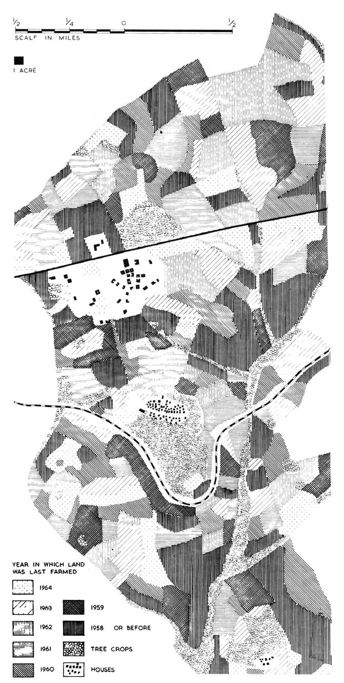
41 walls or fences as villages in the Northern parts of Ghana have. The well organized Asante army fought mainly in the forest and as a dominating force mainly outside its territory. Due to the constant growth period that allows food production year round there are no structures dedicated to the storage of food crops as present in the dry regions of Ghana and Africa that have a pronounced growing season. Each clan owns land that is used for subsistence agriculture based on a rotation of crops. Cycles are between 7-10 years long and include periods when the land is allowed to lay fallow (figure 5.5, 5.6). The elder of each clan decides about which part of the land is cleared, cultivated or allowed to lay fallow. A typical settlement consists of several matrilineal clan groups. In Kwamo there were seven principal lineages in 1963 (Figure 5.5), who together cultivated 229 acres out of a total acreage of 2,427. The map shows the distribution of land among the different clans. The land of an individual clan can be split up in several disconnected pieces. Other important features located on the village lands are the burial grounds, a sacred grove and the stool land, which is land for the use of the current chief. Farmlands are usually reached by foot and can be quite distant from the village and have simple farmhouses for shelter and storage of crops especially in the outer reaches. The day starts very early for people in Asante as in all Ghana as they get up before dawn between 5-6 AM. People could be seen heading for the farm as early as 6:30 AM carrying the standard all-around tool, a simple machete for their work on the farms. Only a fraction of the village land is farmed due to a rotation schedule that allows farmed land to lay fallow and restore their nutrients (Figure 5.6). The tasks of clearing the forest for farming, hunting, construction of houses, cocoa farming and craftwork like the production of furniture is done by the men, while women cultivate the farms, fetch water, prepare food and 35
42 take care of the children. Women are also very active in petty trading, selling a range of products like food, produce and charcoal in kiosks along the street and the market. This adaptation to the sensitive rainforest ecology has allowed people to cultivate the region for centuries and creates a very unique landscape. One of the clan groups represents the Royal group or stool from which the chief is chosen by the elders of the clans. The election is only valid if the Queen Mother approves the choice. A chief can be destooled if there is sufficient amount of complaints. One of the chief s responsibilities is to organize work projects that affect the whole community. In the tradition of communal labor all clans in the village have to take part in maintaining the footpaths, clearing water sources and the construction of public buildings. 36
43 Figure 5.1: The traditional Asante courtyard house from s (plan and section) (Oliver 1976) 37
44 38
45 Figure 5.2: Chief s palace with a number of courts and accommodations for wives, visitors and their retinue (Oliver 1976) 39
46 40
47 Figure 5.3: The development of the Asante house (Oliver 1976) 41
48 42
49 Figure 5.4: Map of the village of Old Kwamo showing detailed land use (Oliver 1976) 43
50 44
51 Figure 5.5: Land cleared and planted in Kwamo in The lands worked by the seven principal lineage groups are indicated (Oliver 1976) 45
52 46
53 Figure 5.6: Farming pattern of the land around the village of Kwamo. The cluster of Old Kwamo lies South of New Kwamo, which is closer to the street. (Oliver 1976) 47
54 48
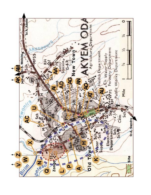
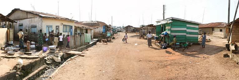
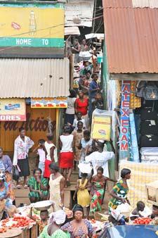
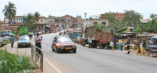
55 CHAPTER 6 A TOUR OF AKYEM ODA This Chapter presents personal observations gathered on numerous walking tours through Akyem Oda. A collection of photographs (figures ) is intended to provide a representative crosscut of Oda s main features and daily life. These images are keyed and their locations within the city indicated on a map (figure 6.1). It was extremely difficult and tedious to acquire any maps from Ghana in a search that included libraries and stores all over the United States and Europe. Unfortunately no city maps of Oda were available at the time this thesis was written; the map presented is an extreme blowup of a topographic map of the region whose quality suffered in the act. This Chapter can best be understood as a photo-essay that constantly refers between text, photos and map to make spatial relationships apparent. Akyem Oda is a small town of around 39,000 people some three hours by automobile from the capitol Accra at the coast (figure 6.2). It is surrounded by tropical rainforest from which patches of farmland were extracted that are intensively cultivated. The farms and fields carved out of the forest can be reached by numerous small footpaths that radiate out from the town in all directions. Major automobile roads lead out of Oda to Akyem Swedru and Achiase in the South, Akyem Asene and Akyem Manso in the East, and Akyem Wenchi in the North (figures 4.2 and 6.1). Oda is divided into three major parts by the rivers Bonware and Apetesu 49
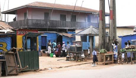
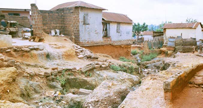
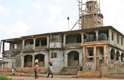
56 and their associated wetlands. These two rivers as well as the others of the region drain into the Birim River which is actively mined for its diamonds. The Birim passes Oda to the North and is not only a source of diamonds but also a means of transportation. The train that used to connect Kade in the North via Oda to the Accra-Takoradi rail line at Achiase (figure 6.2), is now out of service as mentioned in Chapter 4. The overgrown rail road tracks are currently used as a pedestrian trail (figure 6.4-U) providing a convenient shortcut for reaching various parts of town. There are plans to bring train connection back to Akyem Oda and a lot of people are anxiously waiting for that to happen. The abandoned rail station buildings (figure 6.6-AL, figure 7.1-AU) still exist and could be put back into service after restoration, as well as still existing railroad bridges (figure 6.6-AM). Close to the rail station a series of government buildings can be found, health department, forestry department, public works department, assembly hall, district offices, and post office. The town has a defined center made up of the market area (figure 6.6-AD, AE, AF), lorry station (figure 6.6-AG), shops and official buildings. Here life is the busiest during the day, but dies down at night when the area is almost abandoned. The railway, together with the river Bonware and its wetlands, separate Old Town from New Town. Old Town has a high density of traditional buildings, very active community life, the Zongo - the Muslim neighborhood (figure 6.4-L), which includes the main mosque (figure 6.4-Q) and several minor ones, and access to farmlands and diamond mines via a ferry crossing the Birim River (figure 6.5-X). A single main street, Old Town Main Road (figure 6.3-A), runs lengthwise through Old Town and dead ends at the Birim River ferry crossing (figure 6.5-X). There are three paved connections to access Old Town Main Road from New Town. The main road is paved as well, all the other roads and paths in Old Town have earthen surfaces and show 50
57 varying degrees of erosion. The worst case of erosion destroyed part of houses and cut a series of large gullies into the street that are up to 8 deep (figure 6.4-O). Besides the paved roads connecting Old and New Town there are several footpaths and boardwalks that cross the River Bonware and its swampy wetland (figure 6.4-K). The mix of standing water, herbaceous water plants, some few trees allowing open views, and farmhouses lend a scenic quality to the wetland landscape. Akyem Oda was personally visited during two consecutive study trips as part of a Service-Learning Program in the summers of 2004, and Summer Service Programs have been conducted in Ghana for several years, but 2004 was the first year it was done in Akyem Oda. The fourth Summer Service-Learning Program in Oda is planned for summer In 2004, initial lodging in a walled western style hotel in the outskirts of town was soon traded for a traditional courtyard house in the middle of Old Town that was used in the subsequent year as well (figure 6.3-I). At the time the photograph was taken, family members of the host had come for visit to celebrate an important event and were gathering in the courtyard, some were wearing traditional dress. Staying in a traditional house in the middle of a vibrant community provided an opportunity to observe and experience life and culture like family gatherings, funerals, meetings of elders and the rhythm of daily activities in a traditional African town. This house is a recent construction that used the traditional house plan as inspiration. The entrance is at the side, opening towards the compound. A compound is a group of houses that are arranged around a communal open space. The houses are very closely spaced, sometimes butting walls with others, leaving just enough space for a person to walk between. This creates a labyrinthine network of paths and passageways. The private sphere ends with the walls of the house rendering all space beyond them public. Even the courtyard is not completely private in 51
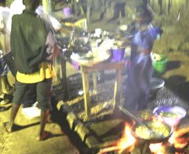
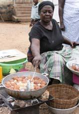
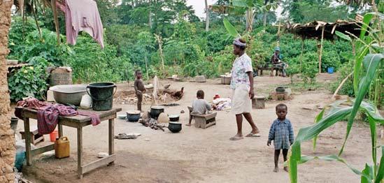
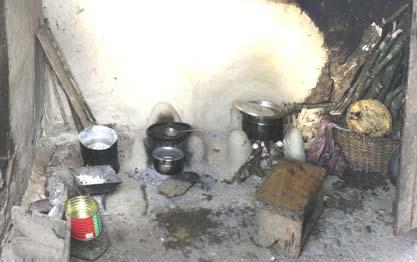
58 the Western sense of the word. They are not open to strangers, but are used by the large circle of friends and family of the occupants. The most private part of the house is the bedroom. All the rooms of the house of our host (figure 6.3-I), several bedrooms, a kitchen and the bathroom can only be reached from the courtyard. The bathroom has a water toilet and a shower which is considered a luxury. The majority of people in Old Town like others all over Ghana uses public toilets (figure 6.4-T) at the edges of the settlement or pan latrines in their houses. It is customary in traditional Asante villages to be organized this way (figure 5.4). Water is usually collected by women and children at wells and standpipes (figure 6.3-B) in the morning, carried back in large bowls, buckets and bags on their heads and stored for later use in barrels in or around the house. The standpipes and wells are a very social place where women would wait for their turn to fill their vessels and use the time for talking, listening and catching up on news. People take their bath either early in the morning or at night after work by filling a pitcher with water from a bucket and pouring it over themselves. The bath is taken in a separate room in the house having a sloped floor that carries the water through a hole in the wall to the outside and into the open gutters. The bathroom can also consist of a screen of wood panels or mud walls that frequently are not higher than the shoulders of a tall person as shown to the right of figure 6.3-G. This courtyard house is a neighbor of the house in figure 6.3-I sharing the same compound, but was built much earlier using earth instead of stone blocks. This new building material was used for the addition or replacement to the left in figure 6.3-G. The barrel for storing water can be seen in the center. The entrance can be reached through a short passageway behind the back of the seated man. The time the picture was taken was early evening and dinner was prepared in the courtyard. Most daily activities are generally performed outdoors and food too is generally prepared in the courtyard of the house, the yard (figure 6.4-N), or compound. 52
59 Cooking is done on low metal cookers burning charcoal (figure 6.3-F) or on an open wood fire (figure 6.3-E). Alternatively, instead of a cooker a construction of three columns formed from clay are used to support a pot above the fire (figure 6.4-M). Old Town Main Road (figure 6.3-A) is a public space pulsating with life from the first daylight until late into the night (figure 6.3-D). This street can functionally be described as an auto, bike and pedestrian traffic route, a work place, a social gathering place, a place to relax and rest after work, a place to shop and sell, a market, a place to eat and a place to play. With all the activities going on in Ghanaian streets people feel very safe and people sleeping in public can frequently be observed (figure 6.4-S). Amy Moore (2002) studied the applicability of Christopher Alexander s A Pattern Language to the Ghanaian built environment for her thesis. One of the patterns she studied was sleeping in public which she reports to have observed just about anywhere. Main Road is the central and busiest part of Old Town. It is around two lanes wide that are equally used by cars, taxis, trucks, animals, and pedestrians, all at the same time (figure 6.3: A). It has the standard open gutter on both sides that are frequently bridged with concrete slabs or wooden boards for access to a store front or entrance of a house. It is flanked by a row of oneor two-story buildings many of which have kiosks or stores opening towards the street (figure 6.3-C). In addition to these permanent stores there are numerous stands and tables, called kiosks, where people prepare and sell food (figure 6.3-E, F). Usually there are people out on the street all the time as most of the daytime hours are spent outside of the house, not only for work related activities but also to socialize (figure 6.3-J) or to watch others. Indeed one of the first and most enduring impressions of Ghana is that there are people everywhere. This is true for cities and towns, but also is a pattern in more remote countryside areas. 53
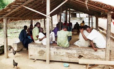
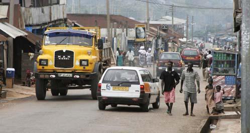
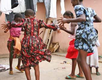
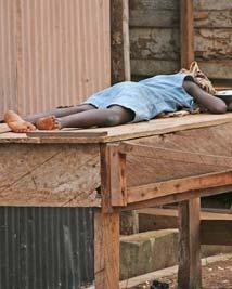
60 The day starts early in Old Town. Muslims are called to prayer at 4:00 AM and shortly after roosters start crowing. At around 5:00 AM women get busy with sweeping the yards and streets, collect water from several of the stand pipes (figure 6.3-B) and start their fires to cook food to be sold directly on the spot along the street or for later sale in the market in New Town. Cooking, as mentioned earlier, is traditionally done open-air, either in the courtyard, or outside of the house in yards or next to the street (figure 6.3-F). At around 6:00 to 7:00 AM children get ready for school sometimes having their bath in the street as vendors get ready to sell breakfast. The ubiquitous taxis bring many people to New Town, however many people and especially schoolchildren walk (6.4-K). By around 10:00 AM things are getting calmer with less people outside. During lunch, food is available again on the street but this is not a tremendously busy time. Traffic and activity levels accelerate again after 3:00 PM when school children come back home and start helping around the house, run errands or simply play games with friends (figure 6.4-R). Not all families have enough money to send their children to school. Sometimes students must miss days or weeks because their parents lack available cash. One regularly sees young girls taking care of their younger siblings or cousins. Children take care of the house, help in the shops or the market, and work on the farms. Children ranging from 6-14 years of age could be seen on their way to the farms, a minute walk away from home each carrying the ever-present machete. The late afternoon at around 5:00-6:00 PM the family comes together and prepares food (figure 6.3-G). The busiest and liveliest time of the day is between 6:00-9:00 PM (figure 6.3-D, E) when people are back home from work, the farmlands or the market. However they don t spend this time sitting at home in private, but rather outside in front of their houses and on the street, getting food from a chop bar (a food stand), meeting friends at a spot (a pub) or just walking up and 54
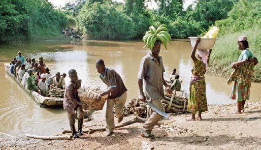
61 down the street. Children are always around and are much more independent and mobile than their counterparts in the United States. They walk long distances to get to school, are sent to the farmland to work, and roam around town with friends without adult supervision. Their social interactions seem to be very rich and numerous, interacting with different age groups, from infants to elders. They converse with different members of the extended family on a daily basis. The whole layout of town, proximity of all the main functions and plenty of trails and paths contribute to all community members being able to be physically independent from others yet always observed. Old Town Main Road passes through the Zongo and ends at the Birim River. The Zongo was originally used for a part of a city or town where foreign workers or immigrants live. It is now commonly used to refer to the Muslim neighborhood of a town which is very often neglected in terms of streets, infrastructure maintenance, and amenities (figure 6.4-L). Muslims are the minority in Ghana and even though there is not a strict separation or hostility between the faiths, with members of both religions working, playing and living together intermarriage occurs and doesn t seem to raise any objections tensions and animosity still exist. Most often lack of support and funding for schools, neglected streets, utilities and other basic needs are the physical reminders of an unequal distribution of services. At the end of Old Town Main Road a ferry hewn from a single tree crosses the river (figure 6.5-X). Raw boards of wood propped up in the shade of a large stand of bamboo (Phylostycas spec.) are used by people waiting for the ferry to get ready and bring them to the farmland and the diamond mines on the other side of the river. Coming back, people carry produce or fire wood on their heads while leisurely stepping out of the boat onto the shore and up the steep bank. The land on the other side is traversed by a network of narrow trails 55
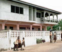
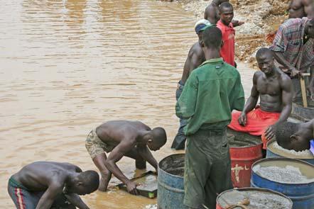
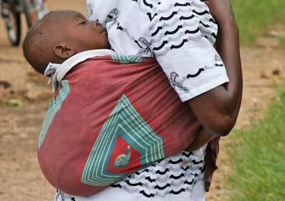
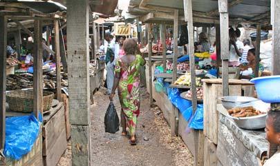
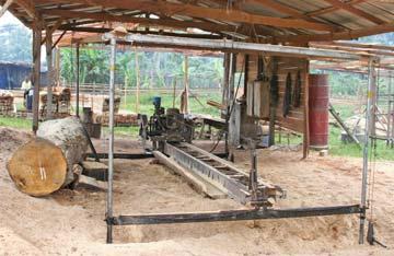
62 crisscrossing through patches of rainforest (figure 6.5-W), dimly lit stands of low-branching cocoa trees with their fruits dangling from the trunks, palm groves, open patches where corn, yams, cassava, pepper, garden eggs and other vegetables are grown. This is sometimes located close to farmers simple houses (figure 6.5-V). These elements create an interesting and enticing park-like landscape that invites hiking and exploration. Diamonds are an important source of income for the people of Oda. These are mainly industrial diamonds and are surface-mined on the banks of the Birim River. Soil is dug up and carried to the river where it is sifted out in the water to extract tiny diamonds. It is hard work predominantly done by men (figure 6.5-Y). At the time of the first visit in 2004 only a small patch along the river was worked by around 40 people. Within a year, the operation had expanded significantly to around 200 people resulting in the excavation of a large sifting pond (figure 6.5-Z). A woman could be observed to the right in the image hauling rocks on her head and another one even carried her baby on the back during work similar to the fashion seen in figure 6.5-AB. It is custom that women carry infants all the time while performing their daily activities till the children are around 2 years old. This close continuous physical contact with the mother is argued to confer large emotional stability and security to the infants. Leaving Old Town by one of the main access roads past the bungalow in figure 6.3-H one reaches the bustling market place (figure 6.6-AD). The market and its narrow aisles (figure 6.6-AE) and metal roof covered stands can be reached by narrow passage ways (figure 6.6-AF) that cut through the enclosing buildings. During night the market is closed and the whole area becomes very quiet and almost deserted. The buildings around the market host shops that sell everything from medicines to tires. They offer services such as shoemaking and watch repair. The streets leading to the market area are lined with small wooden kiosks (figure 6.6-AN). Next 56
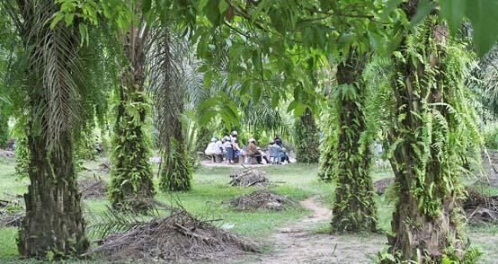
63 to the market is the lorry station which seems even more crowded and busier than the market. Vans transport people and every imaginable good to virtually every village, town and city in Ghana. Every space is used including the roofs (figure 6.6-AG). Larger industrial type manufacturing and processing can be found on the outskirts of town on the road to Akyem Wenchi where sawmills are located (figure 6.6-AK). Local wood is used by woodworkers to produce solid and very refined furniture with only a few hand tools. Unfortunately these products are only sold locally because no export system exists to support a thriving furniture industry. The Garden and Grounds Department is located outside of the center of Oda. On its extensive, park-like grounds a variety of trees provide shade with open clearings where circular benches are set up. Religious groups occupy some of these spaces regularly for singing, preaching, speaking in tongues and reading (figure 6.5-AA). This is a common and everyday occurrence, which makes them a contemporary version of ancient sacred groves. In this context it is interesting to refer to the origin of the Asante kingdom s sacred Kumnini tree. It was planted and understood to be linked to the prospering of the king and therefore his kingdom. This tree stood in a sacred grove for around 200 years playing a significant spiritual role for the Asante. The tree and its grove were later destroyed by the British when their army reached Kumasi. Frequently trees are deemed holy, sacred or containing special spiritual powers and decorated with pieces of fabric. Access to them is restricted and foreigners are warned not to go there lest their heads would be cut off. Whether there is a direct cultural connection between the Kumnini tree plus its associated grove and today s groves and holy trees is hard to tell. Perhaps the occurrence is just incidental. However, the role of the vegetated grove during the last 300 years confers special meaning to the people of Ghana. 57
64 Figure 6.1: Map of Akyem Oda Letters specify the locations where the photos shown in figures were taken. The green rectangle indicates the site of the proposed Three Akyem Park. 58
65 59
66 Figure 6.2: Map indicating railroad lines (Boateng 1966) 60
67 61
68 Figure 6.3: Akyem Oda photo panel #1 Images from Old Town Photographs labeled with a cross have their locations indicated in the map (figure 6.1). A Old Town Main Road. B Two story building and stand pipe along Old Town Main Road. C - One story building with shops along Old Town Main Road. D Night life on Old Town Main Road. E Food vendor during dinner time on Old Town Main Road. F Food vendor frying sweet pastry on coal stove on Old Town Main Road. G Courtyard of traditional house. H Bungalow style house on the road to Old Town. I Courtyard of house hosting Summer Service-Learning Studio participants. J Men s meeting place. 62

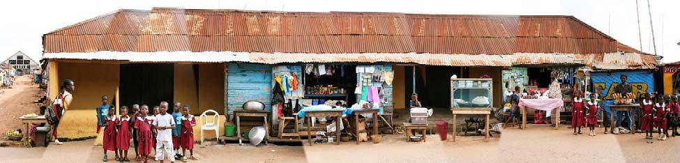
69 A + B C D E F G H + I J 63
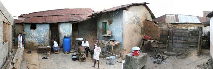
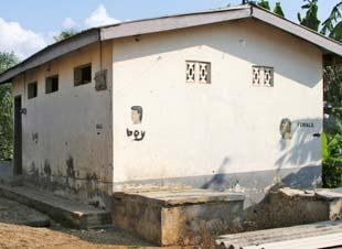
70 Figure 6.4: Akyem Oda photo panel #2 Images from Old Town Photographs labeled with a cross have their locations indicated in the map (figure 6.1). K Pedestrian boardwalk connecting Old and New Town across the wetland. L Street in the Zongo neighborhood. Women gathering around stand pipe. M Cooking corner in traditional house. N Yard of farm house. O Street with severe erosion problems. P Refuse dump. Q Main mosque. R Children in jump and clap game. S Sleeping in public. T Public toilet. U Railroad tracks serving as main pedestrian walkway. 64


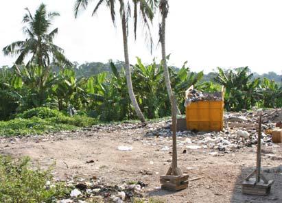
71 K + L + M N + O P + Q + R S T U + 65
72 Figure 6.5: Akyem Oda photo panel #3 Images from farmlands and other areas Photographs labeled with a cross have their locations indicated in the map (figure 6.1). V Farmhouse in stand of cocoa trees. W Trails through the farmlands. X Birim river ferry crossing. Y Sifting for diamonds. Z Surface diamond mining operation. AA Garden department. Church group. AB Infants stay close to their mothers all the time. AC Primary school in Old Town. 66


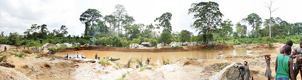

73 V + W + X + Y Z + AA + AB AC + 67
74 Figure 6.6: Akyem Oda photo panel #4 Images from New Town Photographs labeled with a cross have their locations indicated in the map (figure 6.1). AD New Town market area. AE Aisles in market. AF Entrance to market. AG Lorry station. AH Chief s meeting in Elmina at the coast. AI New Town street scene. AJ Annual chief s parade in Elmina at the coast. Ak Sawmill. AL Sign at train station. AM Auto and train bridge across Birim river. AN New Town street scene. 68


75 AD + AE AF AG + AH AI + AJ AK + AL AM + AN + 69
76 CHAPTER 7 THE THREE AKYEM PARK The purpose of the research and observations presented in the preceding Chapters is to present data that could help in the design of a community park in Akyem Oda. The site was identified for redevelopment by the Honorable Frank Busumtwi, District Chief Executive,-Birim South district and the host of all the Summer Service-Learning Studios. The site dimensions were determined in 2005 using a measuring wheel. The site plan, describing existing conditions, was developed using these measurements together with notes and sketches (figure 7.2). After a description of the existing conditions, follows program development and presentation of the proposed design. Existing Conditions The site of the proposed park (figure 7.2, 6.1-green rectangle) stretches for approximately one third of a mile (1610 feet) along a street that leads from the market area towards the government district. Abandoned railroad tracks run around 240 feet parallel to this street and form the Western boundary of the site. The Northern boundary is an intersection where an outdoor pub and restaurant, the Tumasi Spot (figure 7.1-AO, AQ), is located on a triangular piece of land. The site has a total area of around 8.9 acres and slopes down from the street to the 70
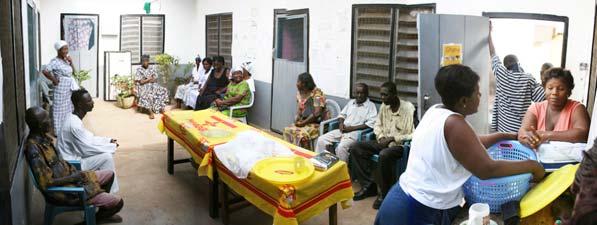
77 railroad line at around 5%. At the same height as the Tumasi Spot next to the railroad tracks is a series of warehouses (figure 7.1-AR) where cocoa awaited shipment by train in earlier times. The Southern boundary of the future park site is the derelict Train Station (figure 7.1-AU). The railroad corridor serves as a major pedestrian traffic route and as storage area for lumber (figure 7.1-AP). The bulk of the site is a random conglomerate of wooden sheds where lumbering, woodworking, metal working and car repair businesses operate (figure 7.2, 7.1-AV). This part of the site has an industrial atmosphere with its stacked lumber, saws, wrecked cars, cars being worked on and noise. There are seven entry points from the street all of which allow access by car (figure 7.2-E1-E7). The main internal passageways are not surfaced but are compacted soil, similar to the remainder of the site. Three of these passageways are dead ends (figure 7.2-A, B, E) the others are interconnected (figure 7.2-C, D, F, G, Y, Z). One passageway connects New Town to Old Town via a boardwalk crossing over a wetland (figure 7.2-D). This passageway and its side connection leading past the Apostolic Divine Church and the District Superintendent s building (figure 7.2-Y) are very busy traffic routes, especially during the late afternoon hours when school children leave school and people go home from work (figure 6.4- K). The site is separated from the railroad by stands of banana and plantain plants (Musa spec.) where at the Southern end close to the rail station a few families live in small houses. There are few permanent buildings on the site besides the Train Station and the cocoa warehouses. These are the wooden Apostolic Divine Church, the stone Superintendent s building, which was linked to the operation of the railroad, and a building close to the cocoa warehouses of unidentified use. Close to the Train Station and formerly associated with its 71
78 operation is a series of residential compounds. Along the street an array of kiosks hosts hairdressers, food vendors and sales of a variety of products. These kiosks effectively prevent the view of the site from the street (figure 7.1-AT). A series of mature specimen trees line the street for the whole length of the site. Around half of these trees have impressive canopies of up to 130 feet in diameter with remarkable epiphytic colonies of Staghorn Fern (Platycerium spec.) and Resurrection Fern (Polypodium polypodioides). Throughout the site a few small trees are dispersed between the jumble of sheds. A small creek traverses the site and eventually drains into the wetland. It is partly littered with plastic waste. The Train Station can be accessed by a surfaced loop road that is flanked by additional rows of banana and plantain trees. The road itself needs repair or replacement and the greenspace in the interior of the loop has a vending kiosk, blocking the view to the Train Station, which consists of two buildings that are connected by a breezeway (figure 7.1-AU). The Northern building hosted the office and the waiting room and the other was a storage building. A pedestrian traffic route runs from the street down to the Train Station crossing the tracks to reach a boardwalk leading to Old Town. Program Development The lumbering and auto mechanics operations close to downtown, the market area, and schools are incompatible functions. The District Chief Executive Frank Busumtwi suggests moving all these businesses to the outskirts of town into the commercial district where currently a series of sawmills is already located (figure 6.1, 6.6-AK) would be a significant improvement. He asked for a park design for the available space that could be accessible to the whole 72
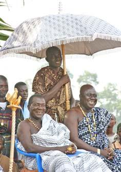
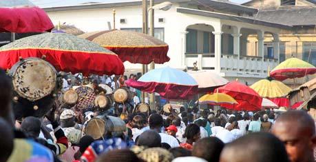
79 community. The new park would need to have a Parade or Durbar Ground for yearly assemblies of the chiefs of the different family clans. As part of these festivals a parade takes place where the chiefs wearing royal dress and gold are carried to the Parade Ground, usually in palanquins, in a procession that includes their entourage in traditional dress, umbrella carriers, and drummers. Figure 6.6-AH and AJ are photographs from the yearly Durbar in Elmina associated with the Baakatue festival, which is a major tourist attraction. Akyem Oda has no dedicated Parade Ground to hold these events. The Parade Ground will be an open space with seating at its perimeter. Another major element of the park was inspired by Asante history. The Kumnini tree that grew in a sacred grove in Kumasi was tied to the fortunes of the Asante kingdom. According to history this tree was planted by Okomfo Anokye who also presented the Golden Stool to the first King of the Asante marking the beginning of the Asante kingdom. The tree and its grove were eventually destroyed by the British. The Akyem and the Asante, both Akan people, are closely related by family relations and share many customs and traditions (Chapter 4). With this in mind it is very interesting to find groves in the Garden and Grounds Department of Akyem Oda used by religious congregations for their worshipping and ceremonies (Chapter 6, figure 6.5-AA). Further, individual trees are often identified as holy, decorated with bands of fabric and their access restricted (Chapter 6). Using this pattern the second main element for the proposed park are three Groves that represent sacred groves for each of the three Akyem people, the Abuakwa, the Kotoku and the Bosome. They are to be distinct from each other with informal stands of native trees enclosing an open space with seating. They are to be identified by sculpture, signage or other marking to represent either one of the three Akyem divisions. The 73
80 three Groves together with giving the park the name The Three Akyem is meant to celebrate the Akyem people and interpret local history for citizens and visitors. The third element of the proposed park is a Cultural Center, which will provide visitors and locals with information about history, culture and traditions of Akyem Oda, the Akyems and the Asante kingdom. It will also be a place for exhibitions, music & dance performances, storytelling, classes in traditional cooking and drumming, and a starting point for guided tours. The extended network of foot trails crisscrossing the farmland and the rainforest are ideal for half- to multi-day hikes or even biking. Not very many tourists visit Akyem Oda at the present. Most people visiting Ghana stay at the coast, where many beach resorts attract leisure tourists and the restored World Heritage List castles in Cape-Coast and Elmina cater to cultural tourists. The larger cities like Kumasi, Takoradi, Tamale and the Mole National Park in the North are focal points of tourism in Ghana as well. With the right infrastructure Akyem Oda has the potential to attract cultural and heritage tourists that are interested in experiencing everyday life in a small African town and even trying or learning some of the local crafts. One group that could be very interested in this kind of heritage tourism is African-Americans, who currently come to Ghana in search of their origins to visit the castles at the coast from where their enslaved ancestors were abducted to the Americas. Offering the opportunity of experiencing first hand how their ancestors actually lived their lives could add a new dimension to their Ghana visit. One of the recommendations of the Summer Service-Learning Studio 2004 was the creation of a guesthouse in Old Town that would be either a converted courtyard building or a newly constructed house in traditional style. This proposal was picked up and is moving forward with the recent acquisition of land in Old Town for the purpose of building a guesthouse. The 74
81 Cultural Center in conjunction with the guesthouse and the already established Tourist Information, together with a program of tours and classes would provide the necessary infrastructure to increase the number of visitors (figure 7.8). Besides the three main elements, the Parade Ground, the Groves and the Cultural Center, the Train Station will be a major feature of the area once train service is reestablished. With the relocation of the lumber businesses the rail corridor will be cleared of stacked wood, but can remain a pedestrian traffic route till train service returns. At that point the Train Station needs to be renovated, the loop road resurfaced or repaired, a new drop-off/pick-up area created, parking provided, and the kiosk within the loop removed. The row of banana and plantain trees flanking the loop road should be extended all the way to the street. A tree should be planted on the South side of the loop road to match the one on the other side. At the current time lack of more detailed information about the future of train service in Oda makes more detailed planning difficult. All the permanent buildings, the Church and the Superintendent s Building, will remain. The banana and plantain trees are to remain as valuable buffer from the railroad and in places are to be extended. The roadside kiosks are a visual barrier that prevents the site s connection with the street and the remainder of town, especially the market area, downtown and the government district. Currently it is the line of kiosks that define the street edge and not the impressive row of mature canopy trees. Therefore the relocation of the kiosks would create a connection between park and street that would redefine the edge of the street with the large trees. Removal of the kiosks might be a difficult task considering how central this location is and how engrained street side vending is in the culture. The gaps in the row of shade trees along the streets should be closed by planting trees of the same species. Small trees along the street that are not similar 75
82 should be removed. This will eventually result in an impressive alee reinforcing a repeated defining feature found throughout the city. New trails will connect the different elements in the park, while the location of the main entry points will be kept. Some of them have to be closed to cars to create a save and relaxing environment for pedestrians. The traffic route connecting the street with Old Town via the railroad crossing and the boardwalk (figure D) must be maintained, along with the other traffic route branching off from the railroad crossing and leading to Tumasi Spot passing the church and the Superintendent s house (figure Y). Design Presentation Based on this program a masterplan for the Three Akyem Community Park was created (figures ). The central element is the rectangular Parade Ground (figure 7.6) located between the existing passageways B and D (figure 7.2). In Ghana participants of festivities or assemblies that include not only chiefs meetings but also weddings, funerals, and other family events, are traditionally set up along the perimeter of a rectangular space with people facing each other. This form was therefore chosen here due to its cultural precedence. The Parade Ground is around 196 feet long and 104 feet wide covering almost 0.5 acre (almost a third of an American football field). The size of future assemblies including spectators is hard to predict, but the proposed area should provide enough space for even large crowds while still achieving a sense of enclosure. The Parade Ground is flanked on all sites by a colonnade of low to medium height flowering trees. Ideally their lowest branches should start at around 6 feet above ground. They are planted in 8 feet wide beds with groundcovers, annuals and perennials that have heights between inches. These beds should separate the colonnade trail from the Parade Ground and the remainder of the site, but still allow visual connection between these spaces. The 76
83 colonnade trail allows spectators to move around the Parade Ground while chiefs are holding their yearly assemblies. At other times it is a connection between the North and the South sides of the park and a leisure circulation route. A series of benches at the perimeter of the Parade Ground provide shaded seating year round for socializing, relaxing, and people-watching. The open space will very likely attract children to play games and sports. Shade trees of the same species as used for the alee along the street flank the main entrance to the Parade Ground and the access points to the main trail. The repeated use of these trees as significant feature helps tie the streetscape together with the interior of the park (figure 7.6). The Parade Ground is connected to the other elements of the park, the Groves and the Cultural Center, by the main trail (figure 7.3). The main trail winds lengthwise through the park having a total of seven connections to the street, with three of them closed to cars (figure E1, E3, E5). The paving of the main trail as of all the other trails (side trails, track trails) will most likely be bare soil. This is the cheapest solution and works quite well all over town and the farmland. A special and beautiful treatment of the main trail could be locally produced brick. Once the former Oda brick factory is producing bricks again it could serve as the logical source. Along the street a sidewalk should be installed to allow a direct route between the South part of town, the Train Station and the market area. Planting beds parallel to the sidewalk will buffer the park from the street. Similar to the beds in the Parade Ground area groundcovers, annuals and perennials between inches high should be used, but in places small shrubs can be used as well. Three Groves, representative of each of the three Akyem people, are tangentially arrayed along the main trail. That way traffic is passing the Groves and not going through their centers, which should be places of tranquility and repose (figure 7.5). The trees making up the Groves 77
84 should be low to medium height. Their foliage and planting pattern should be dense enough to provide some visual protection of the assembly space in the center while still allowing filtered views. Each grove has a unique characterizing species that is dominant while the remaining two species are planted in lower numbers in a naturally dispersed pattern. This planting pattern should represent the interconnection between the three Akyem people while still acknowledging each one s uniqueness. The assignment of the Groves was deliberately random. The assembly space in the center of the Groves can be reached by narrow track trails that curve around the trees. Each center has bamboo benches for seating and a dedication item that could be a plaque in the ground, a sculpture, a stone structure, or whatever the community decides best represents each of the three Akyems. Two of the Groves are enclosed by side trails to increase the number of entry points into them and to also provide circulation alternatives to the main trail. The side trails are flanked by low growing palms forming an enclosed alley way. Open lawn areas surrounding the Groves help to make their distinct shapes visible from the street. They also provide much needed visible connections between the various parts of the park. The Cultural Center is located towards the Northern part of the park close to Tumasi Spot (figure 7.7). The Center is built as a traditional courtyard house and provides exhibitions and information about local history and culture. Classes in drumming, cooking and artwork can be held in the courtyard. In addition guided tours can be booked here. It should also serve as central orientation point for visitors taking walking tours through town. Opposite of the Cultural Center is the storytelling circle where small events and performances can be held. The Cultural Center should work in conjunction with the other tourist institutions, the recently opened Tourist Information Center outside of town, close to the Big Tree, and the proposed guesthouse in Old Town. Together they should complement each other to create a solid tourism infrastructure 78
85 (figure 7.8). The wooded area to the North of the Cultural Center should include agriculturally important species like cocoa as learning demonstration to establish a fitting connection to the neighboring cocoa warehouses. Trees and other important plants should be labeled and explained in terms of importance, use or special properties as if they were in an arboretum. Parking should be provided for visitors arriving by car but also for future reuse of the cocoa warehouses in connection with the reestablishment of train service. A park sign will show the name of the park, a trail map and a general description. Closely associated but not part of the park proper is the Train Station (figure 7.4). An access trail provides a connection between the two. When train service comes back to Oda, the loop road should be repaved and extended with a drop-off area next to the Train Station. A paved plaza with seating should be installed there as well. A few parking spots should be placed in the part of the median closest to the Train Station. The median is to be planted with trees and the flanking rows of bananas and plantains extended to the street. In general the design avoids expensive hardscape installments like walls and columns or ironwork in favor of creating spaces through a sequence of planting patterns that incorporates existing trees as much as possible. The minimum hardscape required is edging for the planting beds and paving of the sidewalk. The sequence of elements should enable a variety of activities, from quiet reflection and relaxation, to festivities, play and partying, to learning and information gathering. The goal is to provide an attractive space to both locals and visitors that caters to each of their needs without creating isolated zones. The circulation pattern provides different routes and experiences. Several parameters such as plant species and dedication items will necessarily require the involvement of the community. This design cannot be a final plan but rather a 79
86 starting point of a process that will eventually lead to a more suitable use of this centrally located space to enrich the lives of local citizens and visitors alike. 80
87 Figure 7.1: Photographs of site for proposed park Photographs labeled with a cross have their locations indicated in the map (figure 6.1). AO Intersection with Tumasi Spot on traffic island (view from South). AP Lumber storage on railroad tracks. AQ Tumasi Spot. AR Cocoa storage buildings (view from North-East). AS Entrance to site (view from North). AT Mature street trees and kiosks line site (view from North-East). AU Rail station (view from West). AV Auto mechanics shop. 81


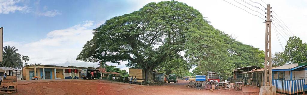
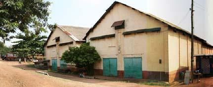


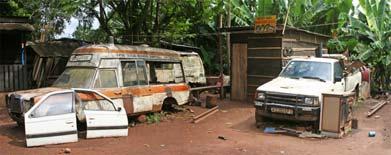
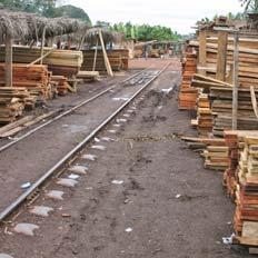
88 AO + AP AQ AR AS AT + AU + AV 82
89 Figure 7.2: Plan of existing conditions of the site for proposed Three Akyem Park 83
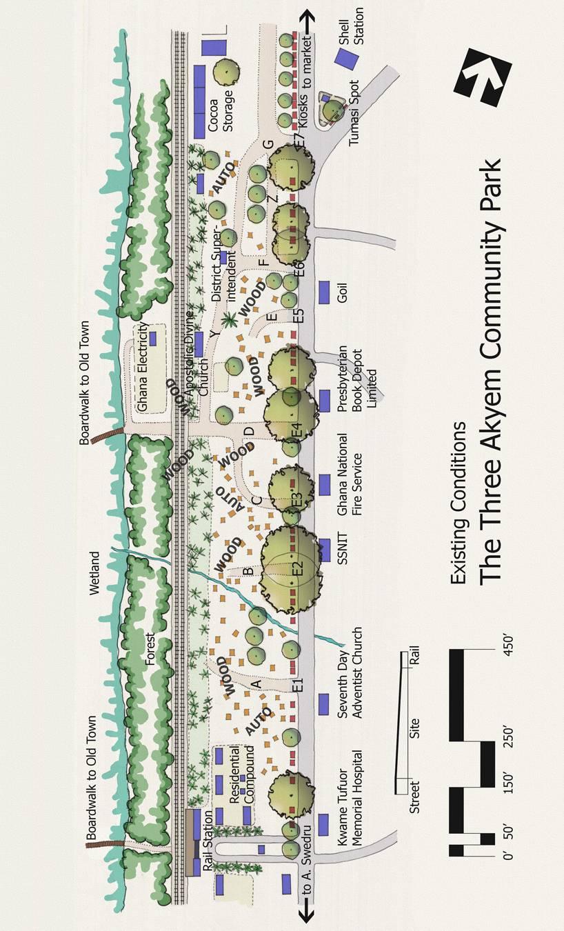
90 84
91 Figure 7.3: Masterplan of proposed Three Akyem Park 85
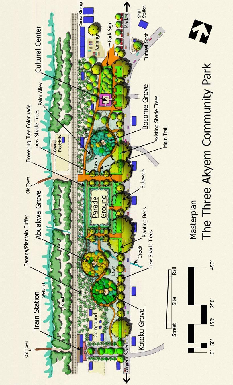
92 86
93 Figure 7.4: Detail plan of Train Station 87

94 88
95 Figure 7.5: Detail plan of Groves 89
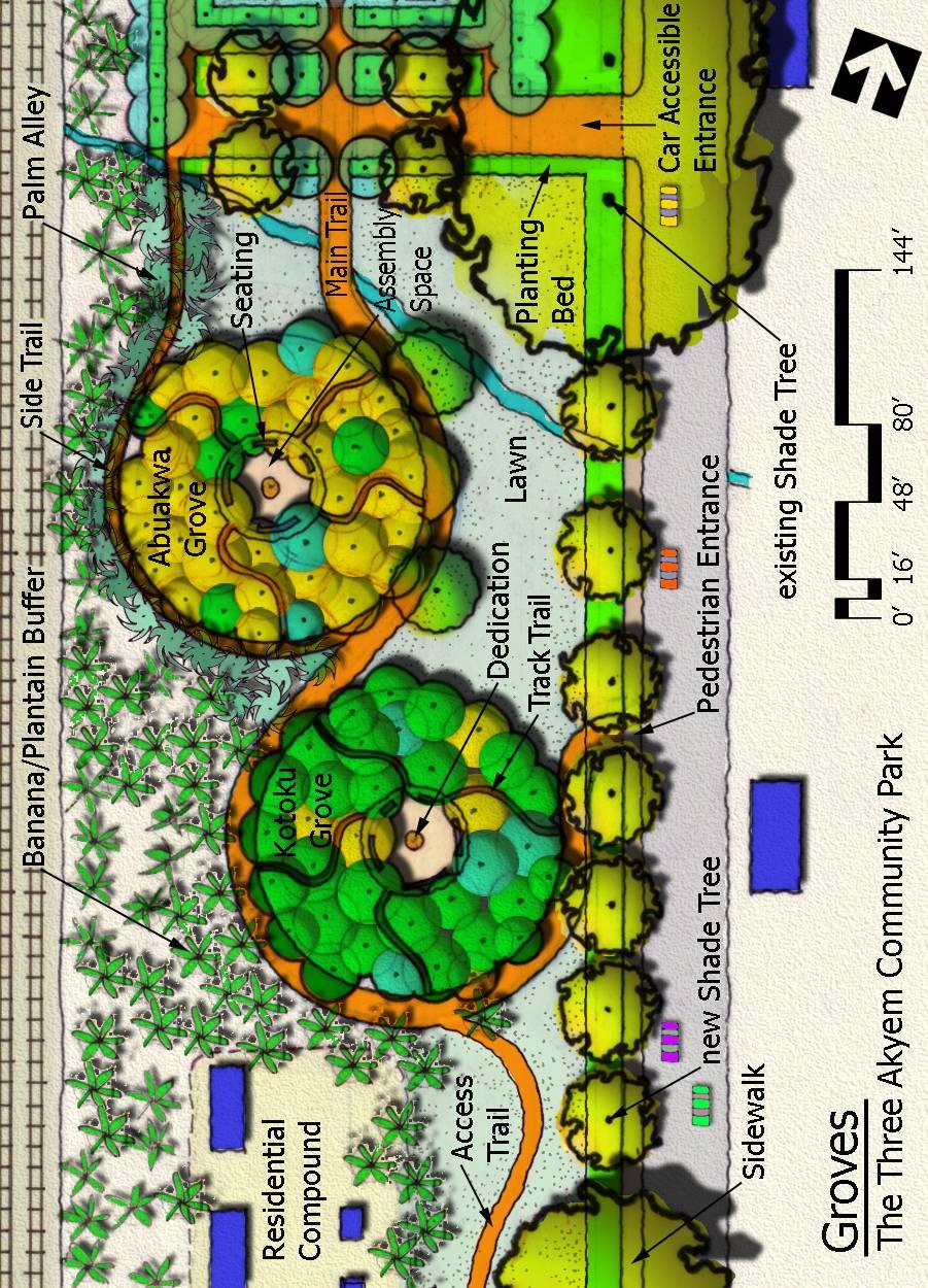
96 90
97 Figure 7.6: Detail plan of Parade Ground 91

98 92
99 Figure 7.7: Detail plan of Cultural Center 93
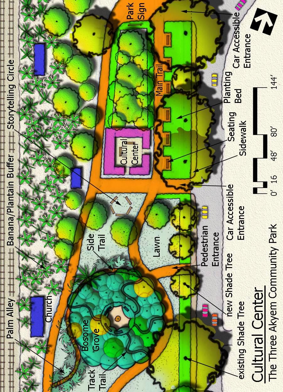
100 94
101 Figure 7.8: Schematic plan of proposed tourism infrastructure for Akyem Oda 95
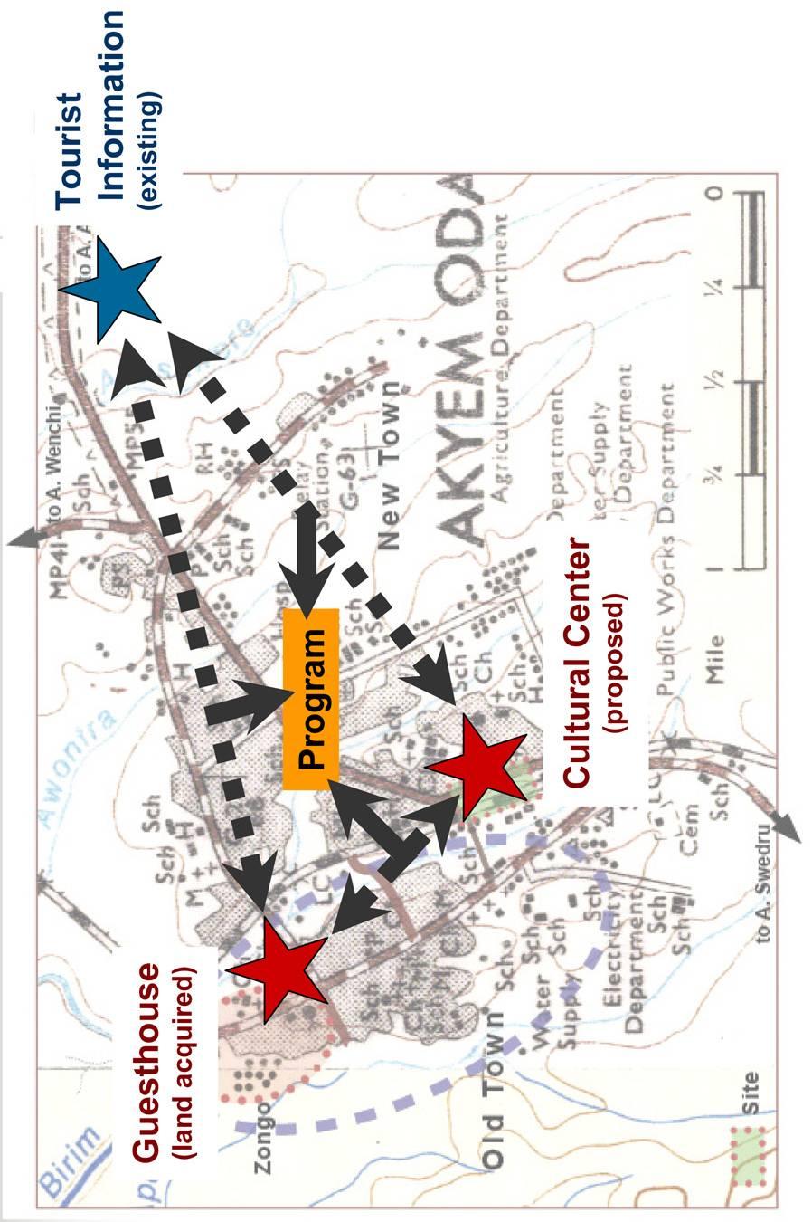
102 96
Physical characteristics and biomes:
 Physical characteristics and biomes: Sahel region, bordering Sahara Characteristics Area suffers from lack of rainfall, over grazing, which causes loss of vegetation and loss of inhabitable areas causing
LANGUAGE OF THE MONTH: YORUBA
 LANGUAGE OF THE MONTH: YORUBA Yoruba is a language spoken in West Africa, mainly in Nigeria. The number of speakers of Yoruba is approaching 65 million. It is a pluricentric language spoken principally
Introduction to Africa
 Introduction to Africa Did you know? Africa has more countries than any other continent. The Sahara is a desert that is the size of the U.S. It s the world's largest desert. Most of the world s gold and
Central Africa Climate?
 Sub-Saharan Africa: All the lands below the Sahara List 4 common traits of countries in Sub-Saharan Africa 4. Define Tribalism and explain how it has affects the region. Chapter 20 Study Guide Define animism
BRITANNICA STUDENT ENCYCLOPEDIA. Africa is the world s second largest continent. More than 50 countries make up
 JOBNAME: No Job Name PAGE: 33 SESS: 682 OUTPUT: Thu Aug 31 10:43:41 2006 38 Africa BRITANNICA STUDENT ENCYCLOPEDIA Africa Africa is the world s second largest continent. More than 50 countries make up
Sub - Saharan Africa
 Sub - Saharan Africa 4/14/2015 Countries with Relative Importance GDP South Africa Gabon Botswana Land Size Sudan Chad Mozambique Madagascar Democratic Republic of the Congo (formerly Zaire) Population
North Africa. Chapter 25. Chapter 25, Section
 Chapter 25, Section World Geography Chapter 25 North Africa Copyright 2003 by Pearson Education, Inc., publishing as Prentice Hall, Upper Saddle River, NJ. All rights reserved. Chapter 25, Section World
Chapter 20. The Physical Geography of Africa South of the Sahara
 Chapter 20 The Physical Geography of Africa South of the Sahara Chapter Objectives Identify the major landforms, water systems, and natural resources of Africa south of the Sahara. Describe the relationship
As Western and Central African nations gained independence, they struggled with varying degrees of success with military rulers and civil wars.
 Unit 4 Western and Central Africa As Western and Central African nations gained independence, they struggled with varying degrees of success with military rulers and civil wars. Cameroon's soccer team
Latin America 11/4/2013. Latin America Today. 580 million people 9% of the world s population Diverse backgrounds:
 Latin America Chapter 10 Human Geography Latin America Today 580 million people 9% of the world s population Diverse backgrounds: Native Americans Europeans Africans Asians 1 Population 393 million live
Mexico. Chapter 10. Chapter 10, Section
 Chapter 10, Section World Geography Chapter 10 Mexico Copyright 2003 by Pearson Education, Inc., publishing as Prentice Hall, Upper Saddle River, NJ. All rights reserved. Chapter 10, Section World Geography
Mediterranean Europe
 Chapter 17, Section World Geography Chapter 17 Mediterranean Europe Copyright 2003 by Pearson Education, Inc., publishing as Prentice Hall, Upper Saddle River, NJ. All rights reserved. Chapter 17, Section
Chapter 13 and 14 Geography Study Guide
 Chapter 13 and 14 Geography Study Guide Multiple Choice Identify the letter of the choice that best completes the statement or answers the question. 1. Which West African country has the largest population
1: The Nile River Valley
 1: The Nile River Valley In Nubia and Egypt, the Nile flows through the Sahara, a vast desert that stretches across most of northern Africa. Before reaching Egypt, the river in ancient times roared through
Nubia s Proximity to Egypt Equals a Lifetime of Egyptian Rule. Ancient Nubia is known for being Egypt s overlooked neighbor. Nubia is also known for
 Walker, Aleta CENG 105- WS Professor Peterson Cultural Analysis- Final Draft November 13, 2012 Nubia s Proximity to Egypt Equals a Lifetime of Egyptian Rule Ancient Nubia is known for being Egypt s overlooked
Economy 3. This region s economy was based on agriculture. 4. This region produced items such as textiles, iron, and ships in great quantities. For th
 Geography 1. This region has a climate of warm summers and snowy cold winters. 2. This region has a climate that is generally warm and sunny, with long, hot, humid summers, and mild winters, and heavy
Chapter 24: Southern Africa. Unit 6
 Chapter 24: Southern Africa Unit 6 Section 1: Physical Geography Landforms Region is made up of 14 countries: 1. Angola 2. Zambia 3. Malawi 4. Mozambique 5. Namibia 6. Botswana 7. Zimbabwe 8. South Africa
Trading Salt for Gold: The Ancient Kingdom of Ghana
 Trading Salt for Gold: The Ancient Kingdom of Ghana By USHistory.org, adapted by Newsela staff on 06.27.17 Word Count 958 Level 1040L A trade caravan traveling in Africa. Ghana played an important role
Nicaragua versus Costa Rica?
 Nicaragua versus Costa Rica? Overview: Today I want to look at Nicaragua versus Costa Rica from both a destination for retiree s standpoint and for potential investment interest. First I'll provide some
Geography (cont) Sorghum, rice, millet, rice, wheat and corn grown on savannahs. Not just one big plain though mountainous and swampy areas too
 Sorghum, rice, millet, rice, wheat and corn grown on savannahs. Not just one big plain though mountainous and swampy areas too") Geography & Society in Africa: 500 BCE-900 CE Geography Around 5000 miles wide and long Various climates, jungles, snow-capped mountains, deserts and rain-soaked areas. 40% desert - largely uninhabitable
Geography & Society in Africa: 500 BCE-900 CE Geography Around 5000 miles wide and long Various climates, jungles, snow-capped mountains, deserts and rain-soaked areas. 40% desert - largely uninhabitable
Name: Period: Date: Mediterranean Sea , '13"N 18 48'30"E. Nile River , '14.06"N 31 26'27.
 Name: : Date: Directions: Label the items in this column on the map. Mediterranean Sea 35.603719, 18.808594 35 36'13"N 18 48'30"E Nile River 26.853906, 3440919 26 51'14.06"N 31 26'27.31"E River Current
Essential Question: What is Hellenism? What were the lasting characteristics of the Roman Republic & the Roman Empire?
 Essential Question: What were the lasting characteristics of the Roman Republic & the Roman Empire? Warm-Up Question: What is Hellenism? Why was Alexander of Macedonia considered great? In addition to
Content Statement: Explain how Enlightenment ideals influenced the French Revolution and Latin American wars for independence.
 Reforms, Revolutions, and Chapter War 9.3 Section 3 Independence in Latin America Content Statement: Explain how Enlightenment ideals influenced the French Revolution and Latin American wars for independence.
Chapter 24: Southern Africa. Unit 6
 Chapter 24: Southern Africa Unit 6 Section 1: Physical Geography Landforms Region is made up of 14 countries: 1. 2. Zambia 3. 4. Mozambique 5. 6. Botswana 7. 8. South Africa 9. 10. Swaziland 11. 12. Madagascar
World of the Incas and the North American Indians. Willow LeTard and Kevin Nguyen
 World of the Incas and the North American Indians Willow LeTard and Kevin Nguyen World of the Twantinsuyu 1300 c.e. in the Andean highlands Notable advances in metallurgy and architecture The Incas had
Text 1: Empire Building Through Conquest. Topic 6: Ancient Rome and the Origins of Christianity Lesson 2: The Roman Empire: Rise and Decline
 Text 1: Empire Building Through Conquest Topic 6: Ancient Rome and the Origins of Christianity Lesson 2: The Roman Empire: Rise and Decline BELLWORK How did Rome s conquests affect the Empire? OBJECTIVES
Egypt and the Nile River Valley System. SC Standards 6-1.3, 1.4, 1.5
 Egypt and the Nile River Valley System SC Standards 6-1.3, 1.4, 1.5 Where is Egypt? Egypt is on the continent of Africa. The River Nile runs through Egypt The capital of Egypt is Cairo Where is Egypt?
Unit 6 vocabulary. Serengeti Plain
 basin Nile River rift valley Mount Kilimanjaro escarpment Sahara aquifer oasis Serengeti Plain canopy Niger delta Sahel the world s longest river, flowing more than 4,000 miles through Uganda and Sudan
Oceania. Australia, New Zealand, and the Pacific Islands. Physical Geography. Where is Australia located?
 Oceania Australia, New Zealand, and the Pacific Islands Physical Geography Australia New Zealand Oceania Where is Australia located? Australia & Oceania are a group of islands located between Asia, Antarctica,
WORLD HISTORY 8 UNIT 2, CH 4.3. The Middle and New Kingdoms PP
 WORLD HISTORY 8 UNIT 2, CH 4.3 The Middle and New Kingdoms PP. 100-104 THE MIDDLE KINGDOM pp. 100-101 1. WHY DID THE WEALTH AND POWER OF THE PHARAOHS DECLINE AT THE END OF THE OLD KINGDOM? The wealth and
Mesoamerican Civilizations
 Mesoamerican Civilizations Human Migration Turn to page 237 and answer the two geography skillbuilder questions: What two continents does the Beringia land bridge connect? From where do scholars believe
Trading Salt for Gold: The Ancient Kingdom of Ghana
 Trading Salt for Gold: The Ancient Kingdom of Ghana By USHistory.org, adapted by Newsela staff on 06.27.17 Word Count 958 Level 1040L A trade caravan traveling in Africa. Ghana played an important role
GHANA. Intercontinental Consultants and Technocrats Pvt. Ltd. A-8, Green Park, New Delhi , India
 GHANA Intercontinental Consultants and Technocrats Pvt. Ltd. A-8, Green Park, New Delhi - 110016, India GHANA The word "Ghana" means "Warrior King", and was the source of the name "Guinea" used to refer
Notes: The Greek World (Chapter 9)
") Notes: The Greek World (Chapter 9) I. Persia Becomes an Empire under Cyrus the Great A. Cyrus the Great led a Persian revolt against the in 580 BCE 1. the Great won independence for Persia from the Medes,
Notes: The Greek World (Chapter 9) I. Persia Becomes an Empire under Cyrus the Great A. Cyrus the Great led a Persian revolt against the in 580 BCE 1. the Great won independence for Persia from the Medes,
All of this week s homework is intended to help you get to know more about the country of Sudan, where Kek is from in Home of the Brave.
 Name: Week 7 Homework All of this week s homework is intended to help you get to know more about the country of Sudan, where Kek is from in Home of the Brave. On the map above, do the following things:
SS7G1 The student will locate selected features of Africa.
 Standards SS7G1 The student will locate selected features of Africa. a. Locate on a world and regional political-physical map: the Sahara, Sahel, savanna, tropical rain forest, Congo River, Niger River,
Latin America and The Caribbean. A Closer Look.
 Latin America and The Caribbean A Closer Look. Mexico Capital: Mexico City The Location of Mexico Mexico is the second-largest country by size and population in Latin America.but the Largest Spanish -
Lesson 1: The Lifeline of the Nile
 Lesson 1 Summary Lesson 1: The Lifeline of the Nile Use with pages 78 81. Vocabulary delta a triangular-shaped area of soil at the mouth of a river silt a mixture of soil and small rocks papyrus a plant
EARLY PEOPLE OF ITALY. Chapter 9: The Ancient Romans
 EARLY PEOPLE OF ITALY Chapter 9: The Ancient Romans INTRO: The Italian peninsula is a mountainous land, shaped like a highheeled boot. Many different people migrated to the Italian peninsula through many
July in Cusco, Peru 2018 Course Descriptions Universidad San Ignacio de Loyola
 July in Cusco, Peru 2018 Course Descriptions Universidad San Ignacio de Loyola For course syllabi, please contact CISaustralia. Please note: Course availability is subject to change. Updated 28 September
Big Idea Rome Becomes an Empire Essential Question How did Rome become an Empire?
 Big Idea Rome Becomes an Empire Essential Question How did Rome become an Empire? 1 Words To Know Reform To make changes or improvements. Let s Set The Stage After gaining control of the Italian peninsula,
The Nile Valley For use with pages 38 46
 READING ESSENTIALS AND STUDY GUIDE 2-1 The Nile Valley For use with pages 38 46 Key Terms cataract: spot of rapid waters in a river (page 39) delta: area of fertile soil at a river s end (page 39) papyrus:
Geography. Greece s Physical Geography is: Peninsula (water on three sides) The Peloponnesus. Mountainous Terrain (see Map dark green)
 The Peloponnesus. Mountainous Terrain (see Map dark green)") Grapes Greece Geography Greece s Physical Geography is: Peninsula (water on three sides) The Peloponnesus Mountainous Terrain (see Map dark green) Extends into the Aegean Sea Includes over 2,000 Islands
Grapes Greece Geography Greece s Physical Geography is: Peninsula (water on three sides) The Peloponnesus Mountainous Terrain (see Map dark green) Extends into the Aegean Sea Includes over 2,000 Islands
Cultural Exploration and Slave Trade in Ghana 11 Days, 9 Nights (1 Night on Plane)
") Cultural Exploration and Slave Trade in Ghana 11 Days, 9 Nights (1 Night on Plane) Day 1 Depart Meals: On Flight, Subject to Availability Grab your passports and get ready to embark on the trip of a lifetime!
Cultural Exploration and Slave Trade in Ghana 11 Days, 9 Nights (1 Night on Plane) Day 1 Depart Meals: On Flight, Subject to Availability Grab your passports and get ready to embark on the trip of a lifetime!
7/27/2010. Regions of Subsaharan Africa. SUBSAHARAN AFRICA II (Chapter 6, pages ) Southern Africa. South Africa: Peaceful Change from Apartheid
 Southern Africa. South Africa: Peaceful Change from Apartheid") SUBSAHARAN AFRICA II (Chapter 6, pages 209-227) Regions of Subsaharan Africa Southern Africa 10 countries, 6 of them landlocked Congo Basin marks northern limit Plateau country Rich in natural resources
SUBSAHARAN AFRICA II (Chapter 6, pages 209-227) Regions of Subsaharan Africa Southern Africa 10 countries, 6 of them landlocked Congo Basin marks northern limit Plateau country Rich in natural resources
STUDY GUIDE. The Land. Chapter 20, Section 1. The Land of Africa South of the Sahara. Landforms Water Systems Natural Resources.
 For use with textbook pages 499 504. The Land Terms to Know escarpment A steep, often jagged slope or cliff (page 500) cataract A towering waterfall (page 500) rift valley A large crack in the earth s
The Pyramids of Ancient Egypt
 The Pyramids of Ancient Egypt By History.com, adapted by Newsela staff on 08.01.17 Word Count 901 Level 1060L The Great Pyramid of Giza, also called the Pyramid of Khufu or Cheops, is the oldest and largest
Human Geography of Canada
 Human Geography of Canada History and Government of Canada Like the United States, people migrated across Beringia into Canada, these people were the ancestors of the Inuit (Eskimos) 16 th and 17 th centuries,
Trading Salt for Gold: The Ancient Kingdom of Ghana
 Trading Salt for Gold: The Ancient Kingdom of Ghana By USHistory.org, adapted by Newsela staff on 06.27.17 Word Count 640 Level 680L A trade caravan traveling in Africa. Ghana played an important role
Chapter Introduction
 Introduction Chapter Introduction This chapter will introduce you to the Ancient Greeks. You will learn about early Greek history, society, and government. Section 1: The Rise of City-States Section 2:
Unit 5: Latin America Today
 Unit 5: Latin America Today In this unit, you will turn your attention to Latin America. You will study the geography of some Latin American countries. You will learn about their history, politics, revolutions,
Benin. Ivory armlet for the Oba of Benin Benin, West Africa 15th-16th century AD. Visit resource for teachers Key Stage 2
 Ivory armlet for the Oba of Benin Benin, West Africa 15th-16th century AD Visit resource for teachers Key Stage 2 Contents Before your visit Background information Resources Gallery information Preliminary
AP US History: An Essential Coursebook (2nd Ed)
") Unit One: Early Native and Colonial Societies (1491-1754) Chapter One: Pre-Columbian Societies AP US History: An Essential Coursebook (2nd Ed) Environment and Geography How did physical features affect
Unit One: Early Native and Colonial Societies (1491-1754) Chapter One: Pre-Columbian Societies AP US History: An Essential Coursebook (2nd Ed) Environment and Geography How did physical features affect
Do Now. What is a theocracy? What did farmers rely on in Mesopotamia? What was the most famous building in Mesopotamia?
 Do Now What is a theocracy? What did farmers rely on in Mesopotamia? What was the most famous building in Mesopotamia? Ch. 2 sect. 2 WORLD HISTORY Impact of Geography The Nile starts in the heart of Africa
THE GEOGRAPHY OF THE NILE. Section 1
 THE GEOGRAPHY OF THE NILE Section 1 The Nile River is the world s longest river. It flows north from its sources in East Africa to the Mediterranean Sea for more than 4,000 miles. THE COURSE OF THE NILE
Chapter 6. Early Societies in the Americas and Oceania. 2011, The McGraw-Hill Companies, Inc. All Rights Reserved.
 Chapter 6 Early Societies in the Americas and Oceania 1 Early Mesoamerican Societies, 1200 B.C.E.-1100 C.E. 2 Origins of Mesoamerican Societies Migration across Bering land bridge? Probably 13,000 B.C.E.,
The Persian Empire 550 BCE-330 BCE
 The Persian Empire 550 BCE-330 BCE The Rise of Persia The Persians based their empire on tolerance and diplomacy. They relied on a strong military to back up their policies. Ancient Persia is where Iran
 Unifying Egypt (p. 85) Ancient Egypt was divided into two parts Upper Egypt and Lower Egypt. One famous legend tells of the king of Upper Egypt, whose name was Menes. He defeated the king of Lower Egypt
BEST OF GHANA WITH AKWASIDAE FESTIVAL 10 DAYS 9 NIGHTS
 BEST OF GHANA WITH AKWASIDAE FESTIVAL 10 DAYS 9 NIGHTS OVERVIEW: Experience the culture and pageantry of the land of history, culture and gold. Join the celebration of the colourful and joyous event, taking
Alexander fighting Persian king Darius III. Alexander Mosaic, from Pompeii, Naples, Museo Archeologico Nazionale.
 Alexander fighting Persian king Darius III. Alexander Mosaic, from Pompeii, Naples, Museo Archeologico Nazionale. IV) HELLENISTIC GREECE The Hellenistic period of Greek history was the period between the
STATEMENT OF SIGNIFICANCE
 1765 Columbia Avenue - Miners Union Hall Miners Hall 2012 Heritage Register - Building 1) Historical Name: Miners Union Hall 2) Common Name: Miners Hall 3) Address: 1765 Columbia Avenue 4) Date of Construction:
TOEFL ibt Quick Prep. Volume 1. Go anywhere from here.
 TOEFL ibt Quick Prep Volume 1 Go anywhere from here. INTRODUCTION Introduction ABOUT THE TOEFL ibt TEST The TOEFL ibt test measures your ability to use and understand the English language as it is read,
APWH chapter 4.notebook. September 11, 2012
 Classical Greece E Ancient Greeks were a seafaring people who learned about civilization from their neighbors (Egypt, Mesopotamia, Phoenicians). Greeks exported valuable goods (olive oil, wine) and traded
Big Idea. Hellenistic culture spreads.
 Big Idea Hellenistic culture spreads. Essential Question What were the effects of Alexander the Great's empire? Words To Know Peloponnesian War an ancient Greek war fought by the Delian League led by Athens
Chapter 4. Daily Focus Skills
 Chapter 4 Daily Focus Skills Chapter 4 On a historical map of the ancient Mediterranean area, locate Greece and trace the boundaries of its influence to 300 BC/BCE. Explain how the geographical location
A: Pre-reading Vocabulary
 - 1 - In this text you are going to read about Egypt and the Egyptian people. There are some words in this text that you won t see very often when you are reading but are important for this text. These
Spanish Missions History and Purpose
 Spanish Missions History and Purpose Columbus's voyage of discovery opened a new world of possibilities for the Spanish. In the Americas, Spain soon began to use its soldiers to increase the size of its
The Rise of Rome. Chapter 5.1
 The Rise of Rome Chapter 5.1 The Land and the Peoples of Italy Italy is a peninsula about 750 miles long north to south. The run down the middle. Three important fertile plains ideal for farming are along
!!!!!!!!!!Mali s Geographic Makeup
 DANU Strategic Forecasting Group May 27th 2016!!!!!!!!!!Mali s Geographic Makeup By Liliana Pirlea Location: Mali is a landlocked country located in West Africa. Mali is the 8th largest country in Africa
Steps in the Management Planning Process
 Steps in the Management Planning Process Developing a management plan for Kalamalka Lake Park will follow a multi-stage process. The planning process for this park is currently in the Draft Management
The Rise of Greek City-States: Athens Versus Sparta By USHistory.org 2016
 Name: Class: The Rise of Greek City-States: Athens Versus Sparta By USHistory.org 2016 This text details the rise of two great ancient Greek city-states: Athens and Sparta. These were two of hundreds of
1st Period Mr. Chavira WORLD GEOGRAPHY. Hector Rodriguez
 1st Period Mr. Chavira WORLD GEOGRAPHY Hector Rodriguez P a g e 1 Table of Contents Latin America Page 2 o Maps Economic Map Page 3 Political Map Page 4 Population Map Page 5 Physical Page 6 o Notes Physical
Ancient Greece. Chapter 6 Section 1 Page 166 to 173
 Ancient Greece Chapter 6 Section 1 Page 166 to 173 Famous Things About Greece The Parthenon Mt. Olympia Famous Things About Greece Plato Aristotle Alexander The Great Athens Sparta Trojan War Greek Gods
The Myth of Troy. Mycenaeans (my see NEE ans) were the first Greek-speaking people. Trojan War, 1200 B.C.
 were the first Greek-speaking people. Trojan War, 1200 B.C.") The Myth of Troy Mycenaeans (my see NEE ans) were the first Greek-speaking people Trojan War, 1200 B.C. Greeks attacked and destroyed independent city-state Troy. The fictional account is that a Trojan
The Myth of Troy Mycenaeans (my see NEE ans) were the first Greek-speaking people Trojan War, 1200 B.C. Greeks attacked and destroyed independent city-state Troy. The fictional account is that a Trojan
LOCATION, CLIMATE, AND NATURAL RESOURCES OF MEXICO
 SS6G3 The student will explain the impact of location, climate, distribution of natural resources, and population distribution on Latin America and the Caribbean. a. Compare how the location, climate,
The Battle of Quebec: 1759
 The Battle of Quebec: 1759 In the spring of 1759, the inhabitants of Quebec watched the river with worried eyes. They waited anxiously to see whether the ships of the French, or those of the British fleet,
The Northern Tropics
 The Northern Tropics The Guianas Countries Guyana, Suriname, French Guyana Culture reflects colonial history Official Languages Guyana English Suriname Dutch French Guyana - French Religions Suriname and
COUNTRY CASE STUDIES: OVERVIEW
 APPENDIX C: COUNTRY CASE STUDIES: OVERVIEW The countries selected as cases for this evaluation include some of the Bank Group s oldest (Brazil and India) and largest clients in terms of both territory
Countries Of The World: Spain
 Countries Of The World: Spain By National Geographic Kids, adapted by Newsela staff on 04.25.18 Word Count 677 Level 830L Image 1. The Puento Nuevo in Ronda, Spain. The bridge was built in the late 1700s
Rivers. Highlights of some of the World s Most Famous Rivers!
 Rivers Highlights of some of the World s Most Famous Rivers! Directions This Power Point presentation contains information about some of the most famous rivers in the world! Students should use this presentation
GENERAL INFORMATION FOR PARTICIPANTS
 GENERAL INFORMATION FOR PARTICIPANTS ENACT CURRICULUM DEVELOPMENT WORKSHOP 16-20 JULY 2012-ACCRA, GHANA About Ghana/Accra WORKSHOP VENUE: HILLBURI HOTEL, ABURI Ghana is bordered to the south by the Atlantic
SESSSION 26. Dr. Raquel Gil Montero Universidad Nacional de Tucumán and CONICET, Argentina
 SESSSION 26 International Economic History Congress, Helsinki 2006; Session 26: Families, Kinship and Forms of Land Ownership in Mountain Societies (16th-20th Centuries) Dr. Raquel Gil Montero Universidad
Living with memory of Caravanserai
 Living with memory of Caravanserai Qing Liao Caravanserai, located along the ancient trade routes covering Asia, North Africa, and southeastern Europe, was akin to nowadays hotels or motels, providing
One Commodity Map. 7. What is a commodity? 8. Explain what a one-commodity country is.
 7. What is a commodity? 8. Explain what a one-commodity country is. 9. What must African countries do in order to become more stable economically? One Commodity Map Countries which OIL is the lone commodity
Roman Expansion: From Republic to Empire
 Roman Expansion: From Republic to Empire January 6 January 10, 2014 I will be able to analyze the political and social institutions of the Roman Republic. I will then be able determine and collaboratively,
The Age of European Expansion
 The Age of European Expansion 1580-1760 Spanish and Portuguese America 1581-1640 1. The Viceroyalty of New Spain was first established in 1535 by King Charles I 1 2. The 15 Captaincies of Brazil were first
Objective: I understand when two groups meet what can happen? Can Sparta and Athens actually get along? Pericles comes to the rescue, maybe?
 Objective: I understand when two groups meet what can happen? Can Sparta and Athens actually get along? Pericles comes to the rescue, maybe? With your Spartan Partner Read Section 1: The Persian Empire
Chapter 25 Geography and the Settlement of Greece. How did geography influence settlement and way of life in ancient Greece?
 Chapter 25 Geography and the Settlement of Greece 25.1 Introduction How did geography influence settlement and way of life in ancient Greece? Tal Naveh/Shutterstock The ancient Greeks learned to use the
SS8G1 The student will describe Georgia with regard to physical features and location.
 SS8G1ab Standards SS8G1 The student will describe Georgia with regard to physical features and location. a. Locate Georgia in relation to the region, nation, continent, and hemispheres. b. Describe the
Egyptian Civilization (3100 B.C-332 B.C.)
") Egyptian Civilization (3100 B.C-332 B.C.) Ancient Egypt -a land of mysteries. No other civilization has so captured the imagination of scholars and public in general. Mystery surrounds its origins, its
Egyptian Civilization (3100 B.C-332 B.C.) Ancient Egypt -a land of mysteries. No other civilization has so captured the imagination of scholars and public in general. Mystery surrounds its origins, its
Bell Work: HINT HINT HINT! Look on pg. 140
 Bell Work: HINT HINT HINT! Look on pg. 140 Chapter 4 Section 4 The Age of Pericles By the end of the lesson, I can compare and contrast the lives of individual citizens in various governmental organizations.
Travel Information Guide
 Travel Information Guide Background on Benin.....1 Visa and Passport Requirements....3 Airline Connections and Travel Tips 4 Hotels.. 5 Background on Benin Benin, officially called the Republic of Benin,
Dr. Dimitris P. Drakoulis THE REGIONAL ORGANIZATION OF THE EASTERN ROMAN EMPIRE IN THE EARLY BYZANTINE PERIOD (4TH-6TH CENTURY A.D.
 Dr. Dimitris P. Drakoulis THE REGIONAL ORGANIZATION OF THE EASTERN ROMAN EMPIRE IN THE EARLY BYZANTINE PERIOD (4TH-6TH CENTURY A.D.) ENGLISH SUMMARY The purpose of this doctoral dissertation is to contribute
Just how big is Africa?
 The United States China India The United Kingdom Portugal Spain France Belgium Germany The Netherlands Switzerland Italy Eastern Europe Japan 11.7 million sq. miles Just how big is Africa? Chapter 18 Section
Greece. made up of two parts: mainland hundreds of small islands. Two main features: Mountains Seas
 Greece made up of two parts: mainland hundreds of small islands Two main features: Mountains Seas Geography MOUNTAIN RANGES mountain ranges separated the small, independent Greek communities caused them
AFRICAN CIVILIZATION. The Kushite Kingdom in Upper Egypt and the Sudan
 AFRICAN CIVILIZATION The Kushite Kingdom in Upper Egypt and the Sudan The Kingdom of Kush The civilization of Kush thrived from about 2000 B.C.E. to 350 C.E. Kush and Egypt had a close relationship throughout
FROM COLONY TO INDPENDENT NATION
 FROM COLONY TO INDPENDENT NATION Quiz: Wednesday! Aztecs, Incas, Cuban Revolution, Zapatista Movement, Independence Movements! HW: finish notes and complete Multi-Level Review Tomorrow: We begin Government
6th Grade Western Hemisphere Geography
 6th Grade Western Hemisphere Geography Multiple Choice Identify the choice that best completes the statement or answers the question. 1 Latin America is located in the A Northern Hemisphere. C Western
7/8 World History. Week 10. The Late Bronze Age
 7/8 World History Week 10 The Late Bronze Age Monday Do Now What do you know about Greece? Objectives Students will identify the main idea and key points in the notes. Students will compare/contrast Greece
Warm-up. A. Exports only manufactured goods B. Should import fewer products C. Needs to import more products D. Does not import or export
 Warm-up As with any small country, Cuba has fewer natural resources than countries such as Brazil. This affects their trade in that Cuba A. Exports only manufactured goods B. Should import fewer products