Blackheath to Blue Gum loop
|
|
|
- Jerome Horace O’Brien’
- 5 years ago
- Views:
Transcription


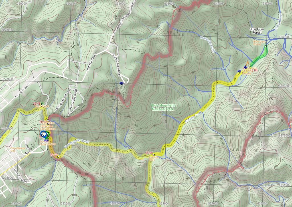
1 Blackheath to Blue Gum loop 2 Days Hard track 24.1 km Circuit m This walk is great for fit people getting into overnight walking, with its fantastic scenery and nostalgia as a classic overnighter. The change from being on the plateau, to in the valley is a dramatic one as the track passes through the bush, canyon and rainforest. Staying the night near Blue Gum Forest in Acacia Flats also adds to the experience. With the public transport options, access to this walk is made easier. 1065m 310m Blue Mountains National Park Maps, text & images are copyright wildwalks.com Thanks to OSM, NASA and others for data used to generate some map layers.

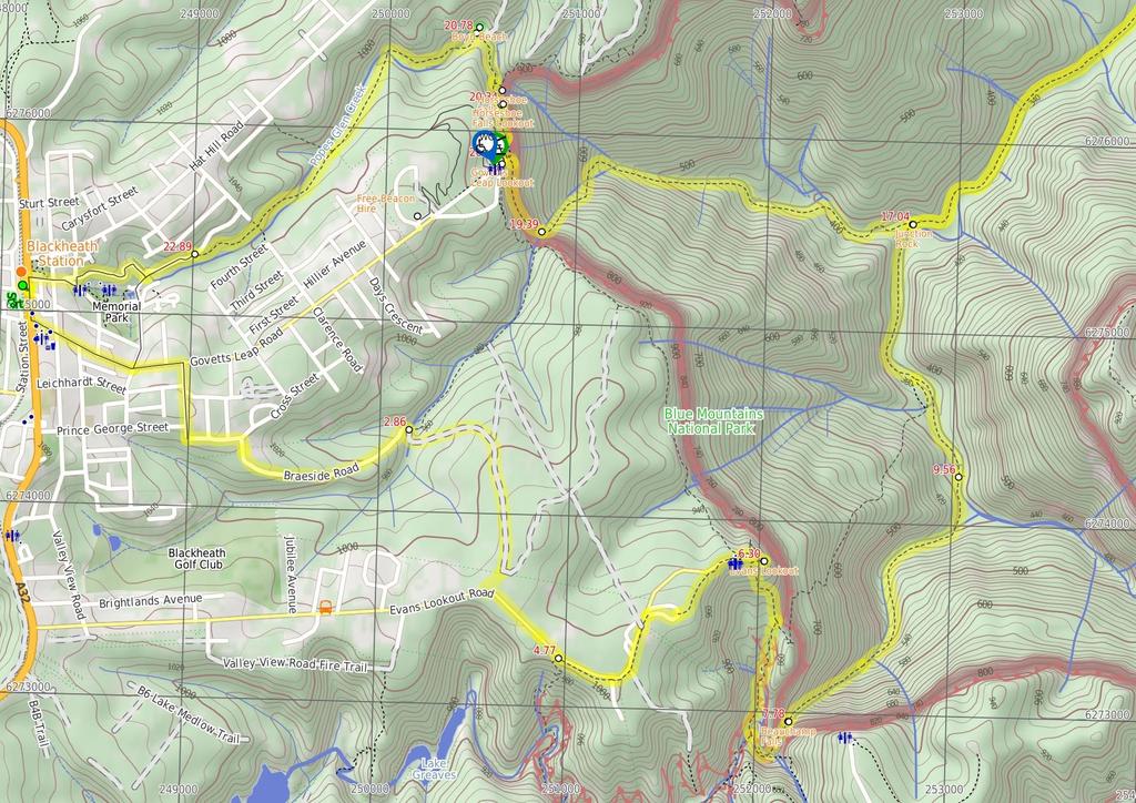
2 Free Beacon Hire Before You walk A Personal Locating Beacon (PLB) is a hand-held device that, when triggered, sends a message to the emergency services with your location. The emergency services staff can then look at your trip intention forms and decide how best to help you. In the Blue Mountains, you can borrow these for no charge, just complete this Trip intention form, and a borrowing form. The device can be picked up from: NPWS Office - Govetts Leap Rd Blackheath - 9am to 4pm 7 days Ph: Katoomba Police Station Katoomba St Katoomba - Anytime Ph: Springwood Police Station - 4 Jerseywold Avenue Springwood - Anytime Ph: More info. Bushwalking is fun and a wonderful way to enjoy our natural places. Sometimes things go bad, with a bit of planning you can increase your chance of having an ejoyable and safer walk. Before setting off on your walk check Evans Lookout Think before you TREK Evans Lookout, Blue Mountains National Park, looks over the spectacular Grose Valley, with its deep gorges, green forest and prominent cliff lines. The fenced lookout is at the end of Evans Lookout Road. There is a rock shelter hut and toilets. The 'Think before you TREK' program developed by NSW Police & NPWS promotes the benefits of planning ahead for your bushwalking trip by using an easy to remember acronym: Beauchamp Falls Beauchamp Falls, Blue Mountains NP, is a beautiful set of falls, split by the rock in the centre of the creek. The falls are created by Greaves Creek, which comes out of the Grand Canyon, above. The falls are approximately 10m tall, with rocks at the base. Junction Rock Junction Rock, Blue Mountains NP, is a rock situated in the middle of the Govetts Leap Brook and Govetts Creek junction. The rock is signposted, giving directions to Evans Lookout, Neates Glen, Acacia Flats and the Blue Gum Forest. Junction Rock is a great place for lunch and a swim in summer. Acacia Flats Camping Ground Acacia Flats Camping Ground, Blue Mountains NP, is situated on the floor of the Grose Valley between Perrys Lookdown and Lockley Pylon. The camp ground is approximately 50m from Govetts Creek and approximately 500m upstream from Blue Gum Forest. Acacia Flats Camping Ground is appropriately named after the dense population of Acacias found in this area. Acacia Flats is a wonderful area to camp with tall shady Blue Gums and level grass clearings which make for a great place to pitch a tent. There is a pit toilet and sitting logs to make camping more comfortable, and plenty of room for large groups. Water is available from Govetts Creek (treat before drinking). 1) Weather Forecast (BOM Central Tablelands District) 2) Fire Dangers (Greater Sydney Region) 3) Park Alerts (Blue Mountains National Park) 4) Research the walk to check your party has the skills, fitness and equipment required 5) Agree to stay as a group and not leave anyone to walk solo adequate supplies of food, water, navigation and first T Take aid equipment. your planned route and tell friends and family when R Register you expect to return. beacon (PLB's) should be carried on walks with E Emergency significant gaps in mobile coverage (check terrain profile). to your planned route and follow the map and walking K Keep trails. Topo Maps The maps provided on wildwalks are helpful, but there are times where you may need maps covering a broader area. Maps that cover this walk include; 1: Map Series:89301S KATOOMBA, 89301N MOUNT WILSON 1: Map Series:8930 KATOOMBA Grade This walk has been graded using the AS The overall grade of the walk is dertermined by the highest classification along the whole track. 4 Grade 4/6 Hard track Length 24.1 km Circuit Time 2 Days Quality of track Rough track, where fallen trees and other obstacles are likely (4/6) Signs Minimal directional signs (4/6) Experience Required Some bushwalking experience recommended (3/6) Weather Weather generally has little impact on safety (1/6) Infrastructure Limited facilities (such as cliffs not fenced, significant creeks not bridged) (4/6)
3 Are you ready to have fun? Please ensure you and your group are well prepared and equipped for all possible hazards and delays. Check park closures, weather information and Fire Danger Rating before setting out. Optional side trips and alternate routes noted are not included in this walks overall grade, length or time estimate. Please allow extra time for resting and exploring areas of interest. The authors, staff and owners of wildwalks take care in preparing this information but will not accept responsibility for any inconvenience, loss or injury you may experience. Please take care, have fun - Happy Walking. Getting there You can get to Blackheath Station (gps: , ) by car, train or bus. Car: There is free parking available. This is a circuit, so you will finish back at the start. Find up to date and more information inlcuding; travel directions, weather, park closures and walker feedback at 0 Free Beacon Hire A Personal Locating Beacon (PLB) is a hand-held device that, when triggered, sends a message to the emergency services with your location. The emergency services staff can then look at your trip intention forms and decide how best to help you. In the Blue Mountains, you can borrow these for no charge, just complete this Trip intention form, and a borrowing form. The device can be picked up from: NPWS Office - Govetts Leap Rd Blackheath 9am to 4pm 7 days Ph: Katoomba Police Station Katoomba St Katoomba - Anytime Ph: Springwood Police Station - 4 Jerseywold Avenue Springwood - Anytime Ph: More info. 0 Blackheath Station (2.9 km 52 mins) From the top of the station steps, this walk heads towards the Great Western Highway and Gardners Inn. The walk turns right down a flight of stairs, then turns left across the Great Western Highway at the pedestrian crossing. Turn right: From the pedestrian crossing, this walk heads towards Gardners Inn, keeping the road to the right. The walk continues along the footpath, turning left opposite the Ivanhoe Hotel, onto Govetts Leap Rd. The walk continues down Govetts Leap Rd to the intersection with Prince Edward St. Continue straight: From the intersection, this walk heads west along Govetts Leap Rd for a block, to the intersection with Boreas St. This walk turns right, down Boreas St to the intersection with Braeside St. Turn left: From the intersection, this walk follows the green signpost to 'Braeside Walk' along the houses on the right-hand of Braeside Street. This walk turns right at the 'Braeside Walk' sign. The walk continues for approximately 70m to the intersection with another service trail. Continue straight: From the intersection, this walk heads down the management track, to the signposted intersection after a parking area on the left Int. Braeside Service Trail and Braeside Picnic Ar (1.9 km 36 mins) Veer right: From the 'Braeside Walk' signposted intersection, this walk leaves the 'Braeside Walk' sign behind on the left as it continues along the service trail towards a waterfall. The track quickly swings left, passing the waterfall (on the left of the track) and continuing up the hill for approximately 400m. The track then tends right for approximately 100m, where is passes a service trail (which heads north). This walk continues south for approximately 600m to a large intersection. Continue straight: From the intersection, this walk heads towards the road, passing a house on the left. The walk continues along James Rd to then turn left onto Evans Lookout Rd. The road tends right, to then pass Victoria Rd on the right. Shortly after Victoria Rd, this walk comes to the Bush Rock Cafe (now closed) on the left. Continue straight: From the Bush Rock Cafe(now closed), this walk heads along the road leaving the cafe behind on the left. The track continues down the road for a short time, passing Somerset Ave on the left, to then come to Neates Glen car park on the right Neates Glen car park (1.5 km 29 mins) Continue straight: From Neates Glen car park, this walk follows the gravel path with the power lines, keeping the road on the left. Soon the path comes to the signposted Kinie-Ger Bush Cabins driveway. Continue straight: From the Kinie-Ger Bush Cabins driveway, this walk follows the gravel path, keeping the road to the left. After approximately 100m, the path leads to an intersection with a management trail. Continue straight: From the intersection, the walk continues to follow the track running parallel to the road, keeping the road on the left. Soon the track opens up to a large clearing with high tension power lines passing over the top. Continue straight: From the clearing, the walk passes under the power lines and follows the bush track, keeping Evans Lookout Rd to the left. Soon this track comes to the exit of the Grand Canyon car park. Veer right: From the intersection, this walk follows the road into the car park, to an 'Evans Lookout' sign. Veer right: From the eastern corner of the Grand Canyon car park, this walk follows the the 'Evans Lookout' sign past the wooden bollards and along the clear bush track. Soon the track emerges and turns right onto Evans Lookout Rd. About 100m along the road the walk comes to the toilet at the start of the car park. Continue straight: From the car park, the walk heads to the other end of the car park (towards the lookouts), to the intersection on the left of the information sign. Continue straight: From the information sign at Evans Lookout car park, this walk follows the 'Evans Lookout' sign down the steps. The track passes a stone shelter on the right as it reaches the railed lookout. 6.3 Evans Lookout Evans Lookout, Blue Mountains National Park, looks over the spectacular Grose Valley, with its deep gorges, green forest and prominent cliff lines. The fenced lookout is at the end of Evans Lookout Road. There is a rock shelter hut and toilets. 6.3 Evans Lookout (1.5 km 54 mins) Turn sharp right: From Evans Lookout, the walk heads down the steps, passing the 'Grand Canyon' sign. From the bottom of the cliff stairs, the walk tends left onto the spur where it continues downhill and weaves past some boulders to a signposted intersection. Veer right: From the intersection, the walk heads down the stairs into the gully following the Neates Glen and Grose Valley signs. The walk winds down the hill for approximately 100m to a railing. From here, the walk continues down the other side of the gully, winding down the hill for a short while. The walk then continues down the right-hand side of the gully to drop onto the creek with a signposted rock in the middle. Veer left: From the intersection, the walk follows the signs to 'Rodriguez Pass' around the canyon side, with the creek on the left. After about 200m, the track crosses the creek. The walk follows the white arrows painted on the rocks winding down between, around and under large boulders for approximately 100m. The track then heads out of the pass, keeping close to the cliff line before winding down the hill to Beauchamp Falls Beauchamp Falls Beauchamp Falls, Blue Mountains NP, is a beautiful set of falls, split by the rock in the centre of the creek. The falls are created by Greaves Creek, which comes out of the Grand Canyon, above. The falls are approximately 10m tall, with rocks at the base Beauchamp Falls (1.8 km 58 mins) Continue straight: From Beauchamp Falls, this walk heads down the hill keeping the valley on the right. The track winds through and around boulders to then meander with the hillside. The track winds for some time before descending more steeply, passing a section of rock overhangs which litter the ground with blocks of sandstone. The track passes this area and continues more steeply to a railed section of stairs which drop to a creek, which it crosses to the other side. Continue straight: From the creek bank, this walk crosses to the other side of the creek. The track then turns left, heading downstream, following blue signposts and white arrows down the valley. The track soon passes a boulder with a large plank underneath it, set up as a seat, before passing a large mossy boulder. Approximately 300m on, the track passes another large mossy boulder with a white arrow at the bottom of the stairs. The track then continues down the hill, crossing the creek to a small clearing next to the creek, in which the track turns right and undulates across the hillside. The track drops into a few creek beds before climbing down a few stairs to an intersection at a campsite on the right Govetts and Greaves Flats (1.5 km 30 mins) Continue straight: From the intersection to the camp area, this walk heads downstream along the creek flats, below on the right of the track. The track then leaves the creek flats to wind and undulate higher on the hillside for approximately 600m, passing a few clearings with fireplace on the left. The track passes a brown arrow with 'Horse Track' scratched into it, and soon after comes to an intersection with a sign, with an arrow pointing back to 'Grand Canyon'. Continue straight: From the intersection, this walk heads downstream following the sign to 'Junction Rock'. The track soon passes a small clearing before climbing higher on the creek bank. After some time undulating, the track comes back onto the creek flats and continues to a section of cliffs on the left. The cliffs are passed by the track across the rockshelf next to a pool in the creek. The track soon turns left to Junction Rock, in the middle of the creek after the rock shelf Junction Rock Junction Rock, Blue Mountains NP, is a rock situated in the middle of the Govetts Leap Brook and Govetts Creek junction. The rock is signposted, giving directions to Evans Lookout, Neates Glen, Acacia Flats and the Blue Gum Forest. Junction Rock is a great place for lunch and a swim in summer Junction Rock (3 km 1 hr 2 mins) Veer right: From Junction Rock, the walk follows the 'Acacia Flat' signs to climb in and out of the creek bank to a clearing with a 'No Camping' sign. The track then turns right to follow the creek bank for approximately 1km, leading up onto a steep creek bank, where it continues for some time. The track then turns right, down the hill, to tend left around a small hill. The walk continues from here along the creek flats, to then pass a pit toilet on your left. The walk continues through the clearing for approximately 60m to Acacia Flats camping area Acacia Flats Camping Ground Acacia Flats Camping Ground, Blue Mountains NP, is situated on the floor of the Grose Valley between Perrys Lookdown and Lockley Pylon. The camp ground is approximately 50m from Govetts Creek and approximately 500m upstream from Blue Gum Forest. Acacia Flats Camping Ground is appropriately named after the dense population of Acacias found in this area. Acacia Flats is a wonderful area to camp with tall shady Blue Gums and level grass clearings which make for a great place to pitch a tent. There is a pit toilet and sitting logs to make camping more comfortable, and plenty of room for large groups. Water is available from Govetts Creek (treat before
4 drinking) Optional sidetrip to Blue Gum Forest intersection (610 m 10 mins) Continue straight: From Acacia Flats camping area, this walk keeps the Grose River far on its right, and the majority of the camping areas to the left of the track. The track soon passes a burnt 'Welcome to Acacia Flats Camping Area' sign before continuing approximately 100m to a creek bed. The walk passes through the creek bed and then skirts around the base of the hill on the left and then continues to meander across the flats to the numerously signposted intersection with the Blue Gum Forest. At the end of this side trip, retrace your steps back to the main walk then Continue straight Blue Gum Forest Blue Gum Forest, Blue Mountains NP, is a large stand of Eucalyptus deanei trees on the junction of the Grose River and Govetts Creek. The magnificent trees stand tall on the flats with low vegetation beneath. The trees of Blue Gum Forest represent the protection efforts of Myles Dunphy, who lead a group to raise the 130 pounds required to buy the Blue Gum Forest - quite a sum in 1931 during the depression - and save it from being cleared. The group were successful and the Blue Gum Forest is now protected within the Blue Mountains National Park. More info End of day 1 This is the planned overnight stay for the end of day 1, happy camping.
5 14.06 Acacia Flats Camping Ground (3 km 1 hr 2 mins) Turn around: From Acacia Flats camping area, the walk leaves the camping area with the Grose River far to the left and the majority of the camping areas to the right of the track. The walk passes a pit toilet on the right after approximately 100m. Continuing along the creek flats before climbing up a small hill, the track contours and undulates for approximately 600m to round a hill which gives views of Pulpit Rock above on the cliffs. The track turns right to climb up the hill, and then left to contour for some time. As the slope lessens, the track descends to the creek bank, which is on the the right. The track continues to contour for approximately 1km just above the creek, on a steep bank which has minor undulations, until it comes across a clearing with a 'No Camping' sign. The track turns left here and descends to the creek bank at a signposted intersection of Junction Rock. Junction Rock 'intersection' sits in the middle of the creek Junction Rock (2.4 km 1 hr 15 mins) Veer right: From Junction Rock, the walk follows the 'Govetts Leap' sign, soon crossing the brook. The track then follows the brook for approximately 150m, to another creek crossing. The track continues, with the creek now on its left, for approximately 60m, before crossing back to the other bank. The track continues for approximately 1km with the creek to the right, and undulates steeply in sections between magnificent waterfalls. A section of track traverses a rock shelf for a short stretch, before continuing to wind up and down (with the creek to the right) to a few sets of steeply-cut stairs. From these, the walk continues to wind over hills to a creek crossing. The track then heads up the spur, winding between views of waterfalls, before tending left further up the hill. The walk leads up the winding steps for some time, until crossing the creek at the bottom of a waterfall cascading off the large cliffs - Govetts Leap falls Bottom of Govetts Leap falls (610 m 42 mins) Continue straight: From the bottom of Govetts Leap Falls, this walk heads north-west, following the blue signs up the hill. The track zigzags its way steeply up to a wall of rock covered by moss, ferns and grasses. The track passes along the base of this cliff to a metal staircase, passing through the rock. The track continues to wind steeply below the cliffline, passing two lookouts before coming to the signposted intersection. Continue straight: From the intersection, this walk follows the sign to 'Govetts Leap carpark' up the stairs. The walk zigzags up the hill before tending left to the signposted intersection. Turn left: From the intersection, this walk heads across the grassed area towards a platform structure. The walk climbs some stairs onto Govetts Leap Lookout, with its great views and sandstone monuments. 20 Govetts Leap Lookout Govetts Leap Lookout is named after the first European man to have enjoyed this view, William Govett, as an assistant surveyor in June Govetts Leap Lookout offers wonderful views over the Grose Valley and the spectacular Bridal Falls. The word `leap` is an old Scottish word meaning waterfall. The lookout is easily accessed from the car park, there are also toilets and picnic shelters nearby. 20 Govetts Leap Lookout (340 m 11 mins) Turn around: From Govetts Leap Lookout, this walk heads down the stairs at the edge of the lookout, keeping the valley to the right. The walk then crosses a grassed area to a well-signposted intersection on the edge of the tree line. Turn left: From the intersection, this walk heads down some stairs, keeping the valley to the right. The walk turns right over a bridge, continuing around the hillside to drop down onto a viewing area and intersection. Veer left: From the intersection, this walk heads down steep stairs, keeping the valley to the right. The track then winds along the cliff top until coming to an intersection, near Horseshoe Falls Lookout Horseshoe Falls Lookout Horseshoe Falls Lookout, Blue Mountains National Park, is a small fenced lookout. There are views down to Horseshoe Falls and across the Grose Valley Horseshoe Falls Horseshoe Falls, Blue Mountains National Park, are sourced by Popes Glen Creek which runs over the cliff into the Grose Valley. The Horseshoe Falls seem to be named after the shape of the valley into which they drop Horseshoe Falls Lookout (440 m 11 mins) Continue straight: From the intersection, this walk heads along the cliff top towards Horseshoe Falls, with the valley below to the right. The track winds for some time around the hillside, to a lookout on the right, before continuing around to a railing some steep stairs. The stairs lead to Popes Glen Creek, where the track continues through the ferns to meet a street sign. Continue straight: From the intersection, this walk follows the sign to 'Popes Glen' keeping the creek below on the right. The track continues for approximately 100m, rising to the left of a prominent rock feature. The walk passes another track on the right (with access to the creek), then continues to rise past the rock feature (on the right - The rock feature has a trail to its top.) This walk continues from the rock feature, heading down the hill to a signposted intersection Optional sidetrip to Boyd Beach (40 m 1 mins) Turn right: From the intersection, this walk heads down the hill following the 'Boyds Beach' sign (under the bush). The walk winds down the rocky steps for approximately 40m to Boyd Beach. At the end of this side trip, retrace your steps back to the main walk then Continue straight Boyd Beach Boyd Beach, Blue Mountains National Park, is a small sandy bank on Popes Glen Creek. The beach is a quiet spot with nice ferns and shade. The beach is a short distance from the Popes Glen track Int. Popes Glen Trk and Boyd Bch Trk (2.1 km 49 mins) Turn left : From the intersection, this walk heads up the hill, following the arrow on the sign pointing to 'Blackheath'. The track continues above the creek (on the right) for some time, then crosses a bridge so that the creek is now on the left. The walk crosses a second bridge, then continues for some time up a rocky hill to an intersection below power lines, with a bridge below on the right. Continue straight: From the intersection, this walk heads up the hill, keeping the creek below on the right. The walk soon crosses the creek at a bridge, continuing along the other side to a small waterfall (on the left). The track then continues up the hill for for a short time, passing an intersection (with access tracks to Clarence Rd). The track continues to head up the hill for approximately 300m to the intersection with Dell St Int. Pope's Glen Trk and Dell St (1.2 km 26 mins) Veer left: From the intersection, this walk heads down Dell St, keeping the bush to the left of the road and houses to the right. The walk soon passes Cleopatra St on the right and continues along Dell St to the intersection with Gipps Lane, on the right (where Dell St changes name to Wills St). Turn right: From the intersection, this walk heads along Gipps Lane, passing a large wooden house to the right of the road. The road tends left onto Robertson Lane which then becomes Wills St. The walk follows Wills Street for sometime to turn left onto Inconstant St and then right onto Gardiner Cres. Gardiner Cres is followed to the Great Western Highway, where there is a petrol station on the left. From here, this walk turns left to follow the Great Western Highway, keeping the petrol station on the left, as the walk heads towards the Gardners Inn pub. This walk continues to the pedestrian crossing, opposite Blackheath Station steps. Turn right: From the pedestrian crossing, this walk crosses the Great Western Highway to turn right up the covered station steps. The walk follows the railway bridge to the top of the station staircase.
6
7
8 Summary navigation sheet for the Blackheath to Blue Gum loop km Up/Dwn Length Initial directions (Use full tracknotes and maps for more detail) Start Blackheath Station , (GR Katoomba, ) 2.86 Int. Braeside Service Trail and Braeside Picnic Area , (GR Katoomba, ) km 52 mins 1.9 km 36 mins km 29 mins 1.5 km 54 mins 1.8 km 58 mins 1.5 km 30 mins 3 km 1 hr 2 mins 610 m 10 mins 0m Continue straight: From Neates Glen car park, this walk follows the gravel path with the power lines, keeping the road on the left. Turn sharp right: From Evans Lookout, the walk heads down the steps, passing the 'Grand Canyon' sign. 3 km 1 hr 2 mins 2.4 km 1 hr 15 mins 610 m 42 mins 340 m 11 mins 440 m 11 mins 40 m 1 mins 2.1 km 49 mins 1.2 km 26 mins Turn around: From Acacia Flats camping area, the walk leaves the camping area with the Grose River far to the left and the majority of the camping areas to the right of the track. Veer right: From Junction Rock, the walk follows the 'Govetts Leap' sign, soon crossing the brook Powered by TCPDF ( From Neates Glen car park , (GR Katoomba, ) Evans Lookout , (GR Katoomba, ) Beauchamp Falls , (GR Katoomba, ) Govetts and Greaves Flats , (GR Katoomba, ) Junction Rock , (GR Katoomba, ) Acacia Flats Camping Ground , (GR Mount Wilson, ) End of day , (GR Mount Wilson, ) Acacia Flats Camping Ground , (GR Mount Wilson, ) Junction Rock , (GR Katoomba, ) Bottom of Govetts Leap falls , (GR Katoomba, ) Govetts Leap Lookout , (GR Katoomba, ) Horseshoe Falls Lookout , (GR Katoomba, ) Int. Popes Glen Trk and Boyd Bch Trk , (GR Mount Wilson, ) Int. Popes Glen Trk and Boyd Bch Trk , (GR Mount Wilson, ) Int. Pope's Glen Trk and Dell St , (GR Katoomba, ) From the top of the station steps, this walk heads towards the Great Western Highway and Gardners Inn. Veer right: From the 'Braeside Walk' signposted intersection, this walk leaves the 'Braeside Walk' sign behind on the left as it continues along the service trail towards a waterfall. Continue straight: From Beauchamp Falls, this walk heads down the hill keeping the valley on the right. Continue straight: From the intersection to the camp area, this walk heads downstream along the creek flats, below on the right of the track. Veer right: From Junction Rock, the walk follows the 'Acacia Flat' signs to climb in and out of the creek bank to a clearing with a 'No Camping' sign. Optional sidetrip to Blue Gum Forest intersection. Continue straight: From Acacia Flats camping area, this walk keeps the Grose River far on its right, and the majority of the camping areas to the left of the track. This is the planned overnight stay for the end of day 1, happy camping. Continue straight: From the bottom of Govetts Leap Falls, this walk heads north-west, following the blue signs up the hill. Turn around: From Govetts Leap Lookout, this walk heads down the stairs at the edge of the lookout, keeping the valley to the right. Continue straight: From the intersection, this walk heads along the cliff top towards Horseshoe Falls, with the valley below to the right. Optional sidetrip to Boyd Beach. Turn right: From the intersection, this walk heads down the hill following the 'Boyds Beach' sign (under the bush). Turn left : From the intersection, this walk heads up the hill, following the arrow on the sign pointing to 'Blackheath'. Veer left: From the intersection, this walk heads down Dell St, keeping the bush to the left of the road and houses to the right.
Victoria Falls to Blackheath Station
 Victoria Falls to Blackheath Station 2 Days Experienced only 22.2 km One way 5 1561m This is a fantastic overnight walk with a sleep in Acacia Flats camping area. The Grose Valley, with its views of the
Victoria Falls and Grose Valley to Blackheath Station
 Victoria Falls and Grose Valley to Blackheath Station 3 Days Experienced only 22.5 km One way 5 158m This walk explores a fantastic section of the Grose Valley. Starting above Victoria Falls, the walk
Victoria Falls and Grose Valley to Blackheath Station
 This walk explores a fantastic section of the Grose Valley. Starting above Victoria Falls, the walk explores the cascades before dropping into the valley for the first nights rest at Burra Korain campsite.
Victoria Falls Lookout to Blue Gum Forest
 Victoria Falls Lookout to Blue Gum Forest 8 hrs Experienced only 13.8 km One way 5 112m This long day-walk follows a remote track down from Victoria Falls lookout, passing the waterfall, and into the Grose
Nature Track. 900m. 789m. 2 hrs 3.1 km Circuit. Hard track 238m. Blue Mountains National Park
 Nature Track 2 hrs 3.1 km Circuit Hard track 238m Largely following the ridges around the top edge of Wentworth Falls, this track is incredibly beautiful. After taking in the great views at Edinburgh Castle
Leura Cascades to Gordon Falls Reserve
 Leura Cascades to Gordon Falls Reserve 1 hr 15 mins 1.8 km One way Moderate track 200m From Leura Park to Gordon Falls Park, this diverse walk offers fantastic views of the Jamison Valley, as well as two
Erskine Creek via Pisgah Rock and Jack Evans
 Erskine Creek via Pisgah Rock and Jack Evans 4 hrs 30 mins 7.1 km Circuit Very experienced only 6 421m This walk visits some great lookouts and explores the lower section of Erskine Creek. Most of the
Merritts Traverse. 1928m
 Merritts Traverse 3 hrs Hard track 5.8 km Circuit 4 167m This walk starts with a scenic journey to the top of the hill on the chairlift. Starting along Merritts Nature walk, this walk soon detours down
Abbotts Falls Walking Track
 Abbotts Falls Walking Track 3 hrs 7.3 km Circuit Hard track 329m This circuit takes you through both dry and moist forest, using a combination of walking trails and wider tracks. The side trip to the dammed
Congewai Track Head (East) to Watagan Headquarters
 to Watagan Headquarters") Congewai Track Head (East) to Watagan Headquarters 7 hrs Hard track 17.2 km One way 4 973m This full day walk starts from the Congewai valley trackhead (east) and follows the Great North Walk up into the
Congewai Track Head (East) to Watagan Headquarters 7 hrs Hard track 17.2 km One way 4 973m This full day walk starts from the Congewai valley trackhead (east) and follows the Great North Walk up into the
National Pass. 893m. 665m. 3 hrs 30 mins 4.6 km Circuit. Hard track 773m. Blue Mountains National Park
 National Pass 3 hrs 3 mins 4.6 km Circuit Hard track 773m 4 This walk offers fantastic views of the Jamison Valley and the surrounding cliffs. Take time to explore the historic and very scenic ledge halfway
Mt Kuring-gai Track to Berowra station
 Mt Kuring-gai Track to Berowra station 4 hrs 15 mins 9.7 km One way Hard track 4 553m This walk explores three valleys, with great displays of wild flowers in spring, and some nice sandstone overhangs.
Wentworth Pass. 893m. 535m. 4 hrs. Hard track 5.1 km Circuit. 692m
 Wentworth Pass 4 hrs Hard track 5.1 km Circuit 4 692m This walk offers a great way to explore the magical, upper section of the Valley of the Waters. The walk starts and finishes at Conservation Hut, which
Guthega to Mt Twynam. 2183m. 1583m. 6 hrs 45 mins 14.8 km Return. Experienced only. 913m
 Guthega to Mt Twynam 6 hrs 45 mins 14.8 km Return Experienced only 5 913m This walk starts from Guthega and makes its way along the Snowy River to the Illawong Lodge, via the Blue Cow Creek flying fox.
Girrakool to Wondabyne station
 Girrakool to Wondabyne station 4 hrs Hard track 9.5 km One way 4 438m This walk starts from the Girrakool picnic area and winds south, through the Brisbane Waters National Park. The walk crosses some long
Staples Lookout to Mt Wondabyne loop
 Staples Lookout to Mt Wondabyne loop 4 hrs 3 mins 1.8 km Circuit Hard track 337m This walk starts and finishes at Staples Lookout, on Woy Woy Rd. The walk follows sections of the Great North Walk around
Berowra Waters to Cowan Station
 Berowra Waters to Cowan Station 3 hrs 30 mins 7.2 km One way Hard track 597m This is a hilly walk out of the beautiful Berowra Waters valley to Cowan Station. There are many wide views across Berowra Creek
Scenic Railway to Ruined Castle
 Scenic Railway to Ruined Castle 7 hrs 30 mins 12.4 km Return Hard track 4 963m This is a very popular, full day walk, in the Katoomba Area, offering great views of the valley. The walk follows the edge
Dadder Cave and Jack Evans track
 Dadder Cave and Jack Evans track 2 Days 10.3 km Circuit Very experienced only 535m This fairly short overnight walk is a great way to explore Erskine Creek. The walking along Erskine creek is mostly off
Girrakool to Wondabyne station via Pindar caves
 Girrakool to Wondabyne station via Pindar caves 7 hrs 30 mins 18.1 km One way Experienced only 5 741m This walk starts from the Girrakool picnic area and winds south, following Piles creek into the Brisbane
Jerusalem Bay Track (Cowan to Brooklyn)
") Jerusalem Bay Track (Cowan to Brooklyn) 5 hrs 30 mins 13.4 km One way Hard track 4 654m This Cowan to Brooklyn Station walk is a popular section of the Great North Walk, with scenery ranging from foreshore
Jerusalem Bay Track (Cowan to Brooklyn) 5 hrs 30 mins 13.4 km One way Hard track 4 654m This Cowan to Brooklyn Station walk is a popular section of the Great North Walk, with scenery ranging from foreshore
Leura to Katoomba via Dardanelles Pass
 Leura to Katoomba via Dardanelles Pass 4 hrs 6.6 km One way Hard track 697m With approximately equal parts cliff-walk and forest track, this track truly shows what the cliff edges of the Jamison Valley
Gibberagong Track. 169m
 Gibberagong Track 2 hrs 30 mins 6.5 km One way Hard track 4 180m Starting in suburban Wahroonga, this wellmaintained track follows Cockle Creek down to Bobbin Head in the Ku-ring-gai Chase National Park.
Crosslands to Berowra Waters return
 Crosslands to Berowra Waters return 6 hrs Hard track 13.7 km Return 4 1005m This return walk starts from the Crosslands Reserve and follows the Great North Walk along Berowra creek. The walk includes some
Berowra to Cowan via Berowra Waters
 Berowra to Cowan via Berowra Waters 6 hrs Hard track 12.9 km One way 4 884m With train station at each end this walk explores the ridges and valleys around Berowra Waters. There are plenty of excellent
Lady Carrington Drive
 Lady Carrington Drive 3 hrs 45 mins 9.7 km One way Moderate track 3 266m This walk follows the historic Lady Carrington Drive alongside the Hacking River. The old road is closed to traffic and provides
The Prince Henry Cliff Walk
 The Prince Henry Cliff Walk 3 hrs 30 mins 6.8 km One way Moderate track 3 575m Going from Katoomba to Leura, this walk covers the top of the cliff line and most of the major lookouts. With brilliant vistas
Hornsby station to Crosslands
 Hornsby station to Crosslands 6 hrs 45 mins 16.1 km One way Hard track 4 938m This section of the Great North Walk starts from Hornsby train station and winds down along the Blue Gum Walk into Fishponds.
Katoomba to Wentworth Falls via the Jamison Valley
 Katoomba to Wentworth Falls via the Jamison Valley 2 Days Experienced only 29.2 km One way 5 2135m This is the two day version of this popular and challenging walk. This walk passes popular sights including
Crosslands to Cowan. 220m
 Crosslands to Cowan 7 hrs 30 mins 14 km One way Hard track 4 1103m This section of the Great North Walk starts from the Crosslands camping area and winds north alongside Berowra creek, passing through
Main Range Track - Loop from Charlotte Pass camping near Mt Townsend
 Main Range Track - Loop from Charlotte Pass camping near Mt Townsend 2 Days Experienced only 27.7 km Circuit 5 1260m This great overnight walk starts from Charlotte Pass and provides access to some of
Main Range Walk - Charlotte Pass to Mount Kosciuszko
 Main Range Walk - Charlotte Pass to Mount Kosciuszko 9 hrs Hard track 21.9 km Circuit 4 920m This full day walk explores some of the greatest alpine country on offer in NSW. The walk grants views of Blue,
Patonga to Staples Lookout
 Patonga to Staples Lookout 6 hrs 3 mins 17 km One way Hard track 4 72m This great walk explores much of the main ridge ridge running through Brisbane Water National Park. The walk visits a number of great
Somersby to Yarramalong via Stringy Bark Point
 Somersby to Yarramalong via Stringy Bark Point 2 Days Hard track 26.7 km One way 4 1201m This section of the Great North Walk starts form the Somersby General Store and follows the Great North Walk north
Patonga to Wondabyne station via Mt Wondabyne
 Patonga to Wondabyne station via Mt Wondabyne 7 hrs 3 mins 19.5 km One way Hard track 4 861m This walk explores some grand views, pleasant cascades, varied bushland and remote areas of Brisbane Waters
Berowra to Hornsby. 9 hrs 18 mins 22.6 km One way. Hard track. 1423m
 Berowra to Hornsby 9 hrs 18 mins 22.6 km One way Hard track 4 1423m One of the longer day walks in Berowra Valley National Park, this walk mostly follows Berowra Creek along the Great North Walk. Excellent
Guthega to Thredbo camping overnight at Wilkensons Creek
 Guthega to Thredbo camping overnight at Wilkensons Creek 2 Days Experienced only 25.8 km One way 5 1364m This great overnight walk explores the Kosciusko National Park between Guthega and Thredbo, visiting
Patonga to Wondabyne station via Pindar Caves overnight
 Patonga to Wondabyne station via Pindar Caves overnight 2 Days Experienced only 28.1 km One way 5 1164m This overnight hike starts from Patonga beach and winds along a section of the Great North Walk,
Main Range Circuit from Guthega
 Main Range Circuit from Guthega 4 Days Experienced only 45 km Circuit 5 2317m This four day walk explores the Kosciuszko National Park, covering many of the key features of the park between Guthega and
Wondabyne station to Somersby Store
 Wondabyne station to Somersby Store 10 hrs Hard track 26.2 km One way 4 1164m This walk, following a section of the Great North Walk, starts from the Wondabyne train station and winds north, into the Brisbane
Crosslands to Brooklyn
 Crosslands to Brooklyn 2 Days Hard track 27.4 km One way 4 1757m From the Crosslands Reserve, this walk heads along the Great North Walk via Berowra Waters, Cowan, Jerusalem Bay and onto Brooklyn. This
Somersby to the Basin Campsite
 Somersby to the Basin Campsite 3 Days Hard track 47.4 km One way 4 2032m This three day walk starts at the Somersby General Store and follows the Great North Walk, heading north, into the the Jilliby State
Cowan to Wondabyne station via Patonga rest area
 Cowan to Wondabyne station via Patonga rest area 2 Days Hard track 33.4 km One way 4 1523m This section of the Great North Walk starts from Cowan train station and wanders past the majestic Jerusalem Bay
Western Commission Track to Dubbo Gully
 This two day walk follows a series of historic roads along clear and wide management trails. This walk explores the great views from Western Commission Track, the sandstone handicraft on the Old Great
Gordon to Hornsby (overnight at Scout camp)
") Gordon to Hornsby (overnight at Scout camp) 2 Days Hard track 25.8 km One way 4 125m This overnight walk starts from Gordon train station and winds through bush filled valleys to Hornsby station. From
Gordon to Hornsby (overnight at Scout camp) 2 Days Hard track 25.8 km One way 4 125m This overnight walk starts from Gordon train station and winds through bush filled valleys to Hornsby station. From
Thornleigh to Cowan. 2 Days. Hard track 35.9 km One way. 2337m
 Thornleigh to Cowan 2 Days Hard track 35.9 km One way 4 2337m Following the Great North Walk and Berowra Creek through Berowra Valley Regional Park, this walk cuts straight through the length of the Park.
GOLDEN EARS PROVINCIAL PARK
 GOLDEN EARS PROVINCIAL PARK Trail Information as of October 10 th 2015 Do not underestimate the mountainous wilderness of Golden Ears Provincial Park. The combination of rugged terrain and rapidly changing
Out and about at Geehi
 Geehi Geehi Flats is a large area of flat floodplain on the banks of the Swampy Plains River. Located within Kosciuszko National Park, it is home to a popular campsite in summer for people wanting to enjoy
Illawarra Escarpment State Conservation Area Walking Tracks
 Illawarra Escarpment State Conservation Area Walking Tracks NPWS Illawarra Area Office Ground Floor, Government Office Block 84 Crown Street Wollongong NSW 2500 02 4223 3000 (Mon-Fri) Royal National Park
The Mendip Way. Route Directions and Maps Uphill to Wells
 The Mendip Way Route Directions and Maps Uphill to Wells Website: www.mendiphillsaonb.org.uk Email: mendip@mendiphillsaonb.org.uk Facebook & Twitter: @MendipHillsAONB Phone: 01761462338 1 Uphill to Loxton
Tiger Mountain State Forest:
 98 60 hikes within 60 miles: SEATTLE 20 Tiger Mountain State Forest: West Tiger Mountain Three Loop i KEY AT-A-GLANCE INFORMATION Length: 5.1 miles round-trip Configuration: Loop Difficulty: Moderate difficult
Sponsored by. statestreet.com
 /STATESTREETISLANDWALK #ISLANDWALKJSY Sponsored by statestreet.com Important Information If you forget everything else PLEASE remember the following.» Remember to check OUT of every checkpoint» If you
Leaden Boot Challenge ROUTE INSTRUCTIONS
 Leaden Boot Challenge ROUTE INSTRUCTIONS Section 1 Alstonefield to Ilam From the village hall car park turn R then L and pass through the village keeping to the R to enter Church Street. Pass the Church
Leaden Boot Challenge 2016 ROUTE INSTRUCTIONS
 Leaden Boot Challenge 2016 ROUTE INSTRUCTIONS Section 1 Alstonefield to Ilam (CP2) From the village hall car park turn R then L and pass through the village keeping to the R to enter Church Street. Pass
1. Waterfall Gully Mt Lofty. 5 Of the Best Hikes in Adelaide
 Adelaide is a beautiful city, and one of the most incredible things about Adelaide is the quality of bushwalking available on the suburban fringe. It is surrounded by the Mt Lofty Ranges, and much of the
East West route and Leatham Molesworth route (route guide) Molesworth Recreation Reserve
 Molesworth Recreation Reserve") East West route and Leatham Molesworth route (route guide) Molesworth Recreation Reserve 0BIntroduction The East West route links the Clarence (Kahutara River in Ka Whata Tu o Rakihouia) Conservation Park
East West route and Leatham Molesworth route (route guide) Molesworth Recreation Reserve 0BIntroduction The East West route links the Clarence (Kahutara River in Ka Whata Tu o Rakihouia) Conservation Park
Hindhead, Keffolds Copse and Gibbet Hill
 point your feet on a new path, Keffolds Copse and Gibbet Hill Distance: 6 km=4 miles Region: Surrey Author: Schwebefuss Refreshments: Punch Bowl Café moderate walking Date written: 14-apr-2015 Last update:
DAY 1: Circular Quay to Greenwich Wharf
 DAY 1: Circular Quay to Greenwich Wharf Total Distance: 14km Time: Approximately 5 hours Walk Notes in Six Sections Section Name Length Time 1:1 Circular Quay to Milsons Point Station 2.5km 50mins 1:2
CWMGIEDD FROM ABERCRAVE
 Abercrave to Cwmgiedd Walk Page 1 Starting from The Abercrave Inn. Grid Ref: SN 824128 From the Abercrave Inn, an 11.3km (7 miles) walk to the foothills of the Cribarth Mountain, then through forest to
Walks in Sydney Stephen Lord
 Walks in Sydney Stephen Lord SYDNEY HARBOUR N.P.: MANLY TO THE SPIT The foreshore walking track from Manly to the Spit passes through sections of Sydney Harbour National Park and offers an opportunity
Hiking Las Vegas.com
 Hike: Juniper Peak up and back Trailhead: Oak Creek Canyon marked Distance: 5.5 miles round trip Elevation gain: 2,200 feet Elevation peak: 6,109 feet Time: 4 to 5 hours - Up and back Difficulty: 3 Danger
DAY 1: Emu Plains to Glenbrook Wednesday, January 2, 2019
 DAY 1: Emu Plains to Glenbrook Wednesday, January 2, 2019 Some sun: 34 C / 21 C 3mm Meeting time: 8.00am @ Our Lady of the Way Catholic Church, Emu Plains [15 Troy Street, Emu Plains; altitude: 32m] Mass:
Difficult Run Stream Valley Park
 Difficult Run Stream Valley Park The more intense mountain bikers have known about for Difficult Run for some time. Equestrians have known it longer. Eight miles of unpaved trail, the Rails to River Trail
Kakadu Highlights No. 9: September 23 - October 6, 2018
 Kakadu Highlights No. 9: September 23 - October 6, 2018 Section 1: Barramundi Creek: September 23-26 We begin with a four to six hour, 350 kilometre drive from Darwin. The last 45 kilometres is on a 4WD
ID: 283 Distance: 6.2 miles Height gain: 500 Metres Map: Explore OL 19 Contributor David and Chris Stewart
 Walkingworld Wild Boar Fell ID: 283 Distance: 6.2 miles Height gain: 500 Metres Map: Explore OL 19 Contributor David and Chris Stewart Features Birds, Great Views, Hills or Fells Description: Wild Boar
A CENTURY OF CONSERVATION Dunphys kowmung adventure 2014 SEPTEMBER 26TH TO OCTOBER 6TH KATOOMBA TO PICTON
 A CENTURY OF CONSERVATION 1914-2014 Dunphys kowmung adventure 2014 SEPTEMBER 26TH TO OCTOBER 6TH KATOOMBA TO PICTON Stage 3 Uni Rover Trail to Yerranderie September 30 to October 1 2014 th st DUNPHY S
Telluride-to-Moab Alternative Singletrack Options
 Telluride-to-Moab Alternative Singletrack Options Day 1 Day 1 Alternate 1: Galloping Goose to Deep Creek. 18.4 miles, ascent 3,530ft, descent 1,388ft. This is fun, flowey, moderate to intermediate singletrack
Bonaqua Mountain Hardware Action Sprint 2013 Discovery Bay,Lantau The Course Route
 Bonaqua Mountain Hardware Action Sprint 2013 Discovery Bay,Lantau The Course Route The start is inside the Discovery Bay plaza and leads out to the main sandy beach where you will run to the end of the
beach. Make the ford and follow the trail out to the junction with Red Creek Tr in an open grassy area.
 Description: This is a moderate to slightly strenuous 22.8 mile backpack (add 2.6 miles if you do the packless out and back to the Lion s Head) that will have you exploring nearly every thing that is The
Charnley Explorer June 24 - July 15, 2018 Bachsten Creek and the Charnley River. Second draft: 14 November 2017
 Charnley Explorer June 24 - July 15, 2018 Bachsten Creek and the Charnley River. Second draft: 14 November 2017 The best part of the original section one is now part of out Gibb Road Gorges trip. The dates
Trail Beginning Elevation: 7553 ft The Poison Creek Trailhead is located at the end of National Forest Road 646E (NF-646E).
.") West Mountain Trails Poison Creek Trail #134 Length: 2.9 miles (4.7 km) Difficulty Horseback: A good trail for the first time west mountain rider, some steep sections Hiking: Most Difficult USGS Maps:
West Mountain Trails Poison Creek Trail #134 Length: 2.9 miles (4.7 km) Difficulty Horseback: A good trail for the first time west mountain rider, some steep sections Hiking: Most Difficult USGS Maps:
Matthiessen State Park Dells Area Hike
 90 Easy Hikes Close to Home At the south end of the hike, you ll climb on top of a mound left over from a former coal-mining operation in the park. Not far from Goose Lake Prairie, the town of Morris hosts
Hiking Las Vegas.com
 Hike: Mt. Wilson via First Creek Canyon route Trailhead: First Creek marked Distance: 10 miles up and back Elevation gain: 3,400 feet Elevation of Peak: 7,070 feet Time: 7 to 9 hours (up and back) Difficulty:
Pontfadog. Walk A. Walk A
 Walk A A Bird s eye view of the village 2km. (1 1 /2 miles); height gain 45m. (150ft) about 45 minutes. Six minutes walk along the main road towards Glyn Ceiriog reach a signpost to Llwynmawr. Take the
GIFFORD PINCHOT NATIONAL FOREST
 GIFFORD PINCHOT NATIONAL FOREST 9341 Wright Meadow 93 Spencer Meadow Spencer Butte 4247' 30 30A 19 24 80 31C Lewis River Lower Falls 5 Quartz Creek 90 Taidnapam Falls Upper Falls 31 Spencer Peak 3861'
LAS VARAS RANCH CA COASTAL TRAIL PROPOSED ALIGNMENT
 LAS VARAS RANCH CA COASTAL TRAIL PROPOSED ALIGNMENT Santa Barbara Trails Council * Prepared by Ray Ford February 1,2012 The following notes accompany the Santa Barbara Trails Council map for the Las Varas
TUPPER DESIGNATED ACCESS ROUTE
 TUPPER DESIGNATED ACCESS ROUTE 1 FOR ACCESS/EGRESS TO CONNAUGHT, LOOKOUT, STONE ARCH, PORTAL PATHS AND TUPPER TRAVERSE EGRESS Length: 2.6km Vertical Gain: +162m / -83m (Values are for access. For egress,
Beautiful Walks from the Blue Ball Inn
 Walk No. 5 RIVER VALLEYS AND MOOR Countisbury, Watersmeet, Hillsford Bridge, Cheriton, Shilstone Hill, Rockford and Chiselcombe. 8.5 MILES APPROX. Walking time four and a half hours approx. OS 1;25,000
Skiing and Snowshoes on Un-groomed Fernan Saddle Terrain
 Skiing and Snowshoes on Un-groomed Fernan Saddle Terrain Three ski or snowshoe routes are available from the Fernan Saddle Parking Lot which either do not cover routes ordinarily groomed for snow machine
Prince Regent National Park
 Prince Regent National Park 23 rd June- 14 th July 2019 Garimbu Creek, Moran and Roe River Area Notes written by Cassie Newnes This area has something for everyone, magnificent scenery, stunning waterfalls,
IRON BARK and COLENSO HUTS 260 Series Map: 1:50, U21 NZ Grid GPS: Geodetic Datum 1949
 IRON BARK and COLENSO HUTS 260 Series Map: 1:50,000 260-U21 NZ Grid GPS: Geodetic Datum 1949 Topo50 Map: BK36 Taoroa Junction GPS: on WGS84 How to get to START: Exit Taupo on SH1 down the lake to Turangi
Bewl Water & the High Weald
 1 Bewl Water & the High Weald Stonegate station - Stonegate - Wallcrouch - Newbarn - Cousley Wood - Wood's Green - Wadhurst station Length: 9 ½ miles (15.3km) Underfoot: Large portions of this path are
Rogue Gorge (Mt. Stella) Roadless Area-- T30S R3E (primarily in portions of Sections 23, 26, 33, 34 & 35)
 Roadless Area-- T30S R3E (primarily in portions of Sections 23, 26, 33, 34 & 35)") Rogue Gorge (Mt. Stella) Roadless Area-- T30S R3E (primarily in portions of Sections 23, 26, 33, 34 & 35) Rogue River-Siskiyou National Forest--High Cascades Ranger District Upper, higher elevation trail
Rogue Gorge (Mt. Stella) Roadless Area-- T30S R3E (primarily in portions of Sections 23, 26, 33, 34 & 35) Rogue River-Siskiyou National Forest--High Cascades Ranger District Upper, higher elevation trail
Photographing Upper Peninsula Waterfalls
 Photographing Upper Peninsula Waterfalls Tod Poirier Freelance Photographer Photography is one of my passions. The following spread showcases several Upper Peninsula waterfalls. At times a single drop
HARDMOORS 55 RACE ROUTE 2018 HELMSLEY - GUISBOROUGH
 HARDMOORS 55 RACE ROUTE 2018 HELMSLEY - GUISBOROUGH HELMSLEY - CHECKPOINT 1 (WHITE HORSE) 1. Leave RACE START, continue ahead on road (Baxtons Sprunt) At crossroads turn right down Canons Garth eventualy
(west) onto Charleston Boulevard. Drive 16 miles on Charleston and turn right into Red Rock
 onto Charleston Boulevard. Drive 16 miles on Charleston and turn right into Red Rock") Hike: North Peak and Ice Box Overlook up and back Trailhead: 2.5 miles up the Rocky Gap Road not mark Distance: 5 miles round trip Elevation gain: 2,694 feet Elevation Peak: 7,094 feet Time: 3 to 5 hours
Hike: North Peak and Ice Box Overlook up and back Trailhead: 2.5 miles up the Rocky Gap Road not mark Distance: 5 miles round trip Elevation gain: 2,694 feet Elevation Peak: 7,094 feet Time: 3 to 5 hours
Printed in China by Designed by Coral Lee Main cover image: Broken Bay
 Woodslane Press Pty Ltd Unit 7/5 Vuko Place Warriewood, NSW 2102 Australia Email: info@woodslane.com.au Tel: (02) 9970 5111 Fax: (02) 9970 5002 http://travelandoutdoor.bookcentre.com.au First published
CAMELBACK MOUNTAIN: CHOLLA TRAIL
 CITY OF PHOENIX :: Camelback Mountain: Cholla T rail 21 CAMELBACK MOUNTAIN: CHOLLA TRAIL IN BRIEF Camelback Mountain is the tallest point in the city of Phoenix. From the 2,704-foot summit of Camelback,
Access. Road from start point (W01) to campground (W56) Water Taxi Pick-up (W03)
 to campground (W56) Water Taxi Pick-up (W03)") WAIKAREMOANA GREAT WALK 260 Series Map: W18 Waikaremoana NZ Grid GPS: Geodetic Datum 1949 Topo50 Maps: BG39 Ruatahuna & BG40 Waikaremoana Gaps: on WGS84 Topo250 Map: Sheet 10 To get to START: Exit Taupo
WAIKAREMOANA GREAT WALK 260 Series Map: W18 Waikaremoana NZ Grid GPS: Geodetic Datum 1949 Topo50 Maps: BG39 Ruatahuna & BG40 Waikaremoana Gaps: on WGS84 Topo250 Map: Sheet 10 To get to START: Exit Taupo
Trail Phasing Plan. Note: Trails in the Clear Creek Canyon area (Segments will be finalized in the future to minimize wildlife impacts
 Note: Trails in the Clear Creek Canyon area (Segments 2 5 and a future JCOS connection) will be finalized in the future to minimize wildlife impacts Trail Phasing Plan P Parking 3 Easy Trail Intermediate
These track notes are intended to compliment the Munda Biddi maps, not replace them.
 Map Route Summary - Map 1: Diversions: Nil Ridden March & April 2014 Document created: Feb 2015 Updated: Sept 2015 These track notes are intended to compliment the Munda Biddi maps, not replace them. While
Fetcham Downs and Bocketts Farm A magical teashop walk
 point your feet on a new path Fetcham Downs and Bocketts Farm A magical teashop walk Distance: 3 km=2 miles or 4 km=2½ miles Region: Surrey Author: Fusszweig Refreshments: Bocketts Farm easy walking Date
Location: Height: Access: Distance: Elevation: Season: Difficulty: Lat/Long: Directions:
 Upper Eagle Falls Upper Eagle Falls (~20 ft.) is a short hike up from the roadside at the Eagle Falls picnic area. It is very difficult to get a parking spot here during the day, so it is recommended to
COLOUR G U I D E. Sydney to Newcastle: Australia s most accessible long-distance walk
 COLOUR G U I D E Sydney to Newcastle: Australia s most accessible long-distance walk Woodslane Press Pty Ltd Unit 7/5 Vuko Place Warriewood, NSW 2102 Australia Email: info@woodslane.com.au Tel: (02)
Tumbler Ridge Global Geopark
 Tumbler Ridge Global Geopark WILDERNESS WATERFALLS These waterfalls are in remote locations, no trails exist, and GPS is required. Not every geosite needs a hiking trail. Providing ready access to all
Hiking Trail Descriptions
 Hiking Trail Descriptions For ye shall go out with joy. And be led forth with peace. The mountains and the hills shall break forth before you in singing. And all the trees of the fields shall clap their
Darwin s gigantic blunder
 Trail Darwin s gigantic blunder Explore how ice shaped the landscape and why Charles Darwin made a nice mess of Glen Roy Time: 1hr 10 mins Distance: 2 miles Landscape: rural At Glen Roy a curious feature
C E N T R A L C A T S K I L L S
 120 C E N T R A L C A T S K I L L S Central Catskills Once out of the southern parts of the Catskills, the Long Path enters the more well traveled and civilized regions. The trail joins the Devil s Path,
HARDMOORS ROUTE DESCRIPTION
 HARDMOORS 60 2016 ROUTE DESCRIPTION RACE START (GUISBOROUGH) - CHECKPOINT 2 (SALTBURN) DISTANCE 9 MILES CUT OFF TIME 1030 GRID REF OS 666 208 1. Leaving the Sea Cadets Hall, turn left onto the road and
3.1 Bowness-on-Solway to Carlisle
 3.1 Bowness-on-Solway to Carlisle Map panel 1 Distance 15 miles (24 km) Terrain minor roads, tracks, field paths and riverside footpath, muddy in places Grade easy, with gentle gradients on undulating