Berowra to Cowan via Berowra Waters
|
|
|
- Charity Floyd
- 5 years ago
- Views:
Transcription

1 Berowra to Cowan via Berowra Waters 6 hrs Hard track 12.9 km One way 4 884m With train station at each end this walk explores the ridges and valleys around Berowra Waters. There are plenty of excellent views, especially at Naa Badu Lookout and the many creek vantage points along the way. There are some solid climbs on this walk so be sure to allow enough time. Berowra Waters, in the middle of the walk, is a great place for lunch or an ice cream, by taking the optional side trip across the river, on the free car-ferry, which is a pleasant ride in itself. 221m 2m Berowra Valley National Park Maps, text & images are copyright wildwalks.com Thanks to OSM, NASA and others for data used to generate some map layers.

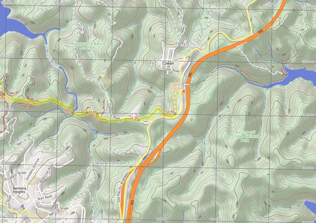
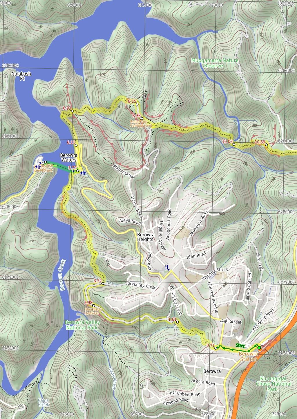
2 Naa Badu Lookout Before You walk Naa Badu Lookout offers magnificent views south over Berowra Creek as well as over Sams and Calna Creeks. Naa Badu means 'See water' in the Aboriginal tribal language of the Dharug people. It is believed that Berowra Creek was the boundary between the Dharug and Guringai Aboriginal peoples. The lookout is fenced, has a bench seat, picnic table and a fair amount of natural shade. Bushwalking is fun and a wonderful way to enjoy our natural places. Sometimes things go bad, with a bit of planning you can increase your chance of having an ejoyable and safer walk. Before setting off on your walk check The Fish Café This seafood restaurant is located on the western side of the Berowra Waters Ferry, and offers casual dining with a great menu, overlooking the marina and river. The restaurant is open 7 days a week for breakfast and lunch, with dinner available on Friday through Sunday. The cafe is open 8:30 9pm Wed-Sun and closes at 3pm Mon & Tuesdays. Takeaway is also available, and the nearby reserve provides picnic tables, toilets, children's playground and parking. Kayak hire is available from the marina building. The Fish Café is located at 199 Bay Road, Berowra Waters, and the phone number is (02) Waterview Restaurant On the western side of Berowra Waters Ferry (free trip), just a short walk up the road, is the Waterview Restaurant, upstairs at the marina. The restaurant specialises in seafood, but also caters for other tastes in restaurant style dinning. Some sittings offers A la Carte meals from $25, and other sittings offer a fresh and cooked seafood buffet. Please call ahead, as the restaurant is also a popular venue for weddings. Open Friday-Sunday for lunch and dinner. Phone (02) Bay Rd Berowra Waters, NSW 2082 Ridge Top Campground About 800m from Turners Rd, Berowra Heights lies this pleasant ridge top campsite. This is a fairly popular campsite on the Great North Walk, providing a flat area with plenty of shade. There are no facilities (or water) at this large campsite. A faint track leads west from the campsite to an unfenced cliff with great views over the Berowra Waters Valley. 1) Weather Forecast (BOM Metropolitan District) 2) Fire Dangers (Greater Sydney Region) 3) Park Alerts (Berowra Valley National Park, Muogamarra Nature Reserve) 4) Research the walk to check your party has the skills, fitness and equipment required 5) Agree to stay as a group and not leave anyone to walk solo Think before you TREK The 'Think before you TREK' program developed by NSW Police & NPWS promotes the benefits of planning ahead for your bushwalking trip by using an easy to remember acronym: adequate supplies of food, water, navigation and first T Take aid equipment. your planned route and tell friends and family when R Register you expect to return. beacon (PLB's) should be carried on walks with E Emergency significant gaps in mobile coverage (check terrain profile). to your planned route and follow the map and walking K Keep trails. Topo Maps The maps provided on wildwalks are helpful, but there are times where you may need maps covering a broader area. Maps that cover this walk include; 1: Map Series:91304N COWAN 1: Map Series:CMA Ku-ring-gai Chase National Park Tourist Map 1: Map Series:9130 SYDNEY Grade This walk has been graded using the AS The overall grade of the walk is dertermined by the highest classification along the whole track. 4 Grade 4/6 Hard track Length 12.9 km One way Time 6 hrs Quality of track Rough track, where fallen trees and other obstacles are likely (4/6) Signs Directional signs along the way (3/6) Experience Required Some bushwalking experience recommended (3/6) Weather Forecast, unforecast storms and severe weather may impact on navigation and safety (4/6) Infrastructure Limited facilities, not all cliffs are fenced (3/6)
3 Are you ready to have fun? Please ensure you and your group are well prepared and equipped for all possible hazards and delays. Check park closures, weather information and Fire Danger Rating before setting out. Optional side trips and alternate routes noted are not included in this walks overall grade, length or time estimate. Please allow extra time for resting and exploring areas of interest. The authors, staff and owners of wildwalks take care in preparing this information but will not accept responsibility for any inconvenience, loss or injury you may experience. Please take care, have fun - Happy Walking. Getting there You can get to Berowra Station (gps: , ) by car, train or bus. Car: There is free parking available. You can get back from Cowan trackhead (gps: , ) by car, train or bus. Car: There is free parking available. Find up to date and more information inlcuding; travel directions, weather, park closures and walker feedback at 0 Berowra Station (710 m 14 mins) From the entrance to Berowra train station, this walk follows the 'Berowra Waters' arrow on the 'Great North Walk' sign, crossing the highway at the traffic lights. On the other side of the highway, this walk turns left and follows the footpath past a series of local shops and cafes for about 150m, then turns right onto Berowra Waters Rd. The footpath passes the post office then Caltex service station, then the walk crosses 'The Gully Rd'. Continuing along the Berowra Waters Rd footpath, this walk passes the park and then crosses the road just to the right of the roundabout. Turning left in front of the community hall, this walk immediately turns right at Crowley Rd, and comes to the open grassy area behind the community hall, where a sign in the park points back to 'Berowra Station' Crowley Road track head (900 m 21 mins) Turn right: From the small park on Crowley Rd, this walk follows the 'Crosslands' sign downhill, tending left behind the houses. The track soon bends right and leads quite steeply down a series of steps for about 120m, then tends left and flattens out on an unfenced rock platform. From here, the track leads down a metal staircase then heads fairly steeply down along a rocky track. The track begins to flatten out over the next 400m, crossing the gully twice, then leads down to a three-way intersection marked with a couple of arrow posts. Veer right: From the intersection, this walk follows the arrow post downhill and soon crosses a small creek. The track then continues up the other side of the valley, over a small rise, then leads down to an intersection with a management trail, marked with a couple more arrow posts Int of Berowra service trail and GNW (1.4 km 34 mins) Veer right: From the intersection, this walk follows the Great North Walk arrow down the wide management trail for about 40m, then continues up the moderately steep hill to a wide three-way intersection, where a sign points back towards 'Berowra Station'. Veer left: From the intersection, this walk follows the 'Crosslands' sign as the trail bends left, leading down the hill. The trail then undulates around the side of valley for about 300m and crosses a small creek (where the trail is gravel). The trail then heads generally uphill for about 600m, before a last little downhill stretch leads to an intersection (with a track on your left) and a 'Berowra Station' sign pointing back along the track. Continue straight: From the intersection, this walk follows the 'Berowra Waters' sign gently down along the management trail, keeping the valley to your left. The trail gently undulates along the side of the hill, enjoying some glimpses up to the cliff faces (on the right). After about 180m, the trail crosses a concrete drain, then leads up the hill to find the signposted 'Naa Badu' lookout and its great view Naa Badu Lookout Naa Badu Lookout offers magnificent views south over Berowra Creek as well as over Sams and Calna Creeks. Naa Badu means 'See water' in the Aboriginal tribal language of the Dharug people. It is believed that Berowra Creek was the boundary between the Dharug and Guringai Aboriginal peoples. The lookout is fenced, has a bench seat, picnic table and a fair amount of natural shade Int of Naa Badu Lookout (540 m 11 mins) Continue straight: From the 'Naa Badu' lookout, this walk follows the management trail over the small rise and across the concrete ditch, keeping the valley to your left. The trail leads around the side of the hill for about 300m, gently undulating to come to an intersection with a narrow track and small clearing (on your left, as the trail bends right), just past the large scribbly gum. (This informal track leads down to an unfenced rock platform, with filtered views over Berowra Creek). Continue straight: From the intersection, the walk follows the wide trail gently downhill as it bends right, keeping the valley to your left. After about 140m, the trail narrows a bit, leading down a few short but steeper sections to an intersection (with some steps on your left), where a 'The Great North Walk' sign points back up along the trail Int of GNW and Berkeley Close service trail (2.2 km 1 Hr) Turn left: From the intersection, the walk follows the 'Berowra Waters' sign down the timber steps. The walk then crosses Banggarai Creek using a timber bridge, and leads up some timber steps. The rocky track then leads up some more timbers steps, between two rocks then over a few rocks, where the track then flattens out. The now flat, sandy track winds through the forest for about 150m and passes a timber seat, then leads down across a small gully before the track begins to climb again. The track leads up some more timber steps, then the walk climbs two metal pegs in the rock and continues to climb steeply up the rock and timber steps. After 60m, the track flattens out again, leading gently up through the scribbly gum and angophora forest for just over 100m to a three-way intersection marked with a couple of GNW arrow posts. Turn left : From the intersection, this walk follows the GNW arrow post north-west down the sandy track, directly towards the valley. The track soon becomes rocky and leads fairly steeply down the hill for about 150m before mostly flattening out and coming close to the top of an unfenced cliff with good views over Berowra Creek. Here the rocky track continues more gently down along the top of the ridge for about 200m and comes to a large rock platform. This walk veers right to lead down the gap in the rock, climbing down some steel pegs to where the track flattens out again. The track leads across the saddle for about 60m then veers left and follows along the base of a long rock wall (on your right). Here the track leads down around the side of the ridge for just over 400m, passing some unfenced views for rock platforms then down some sandstone steps to find a tall sandstone overhang with a timber seat. From this cave, this walk continues along the base of the rock wall, and soon bends left and winds fairly steeply down a series of rock and timber steps to come to the edge of Berowra Creek (where there is a 'no wash' sign facing the water from the rock platform). The track leads along the shore line for a short time to head onto the rock platform in Washtub Gully. Continue straight: From Washtub Gully, this walk crosses the creek and follows the track, keeping Berowra Creek not far to your left. After about 50m, the track passes an old partially sunken boat, then about 100m further on, the track passes a view point that is an obviously popular (but not recommended) jumping spot. The track then soon leads up some steps and over a rise behind the 'Berowra Waters Garden House' restaurant, then heads down the steps to come to the signposted 'Berowra Waters Trackhead' on 'Berowra Waters Rd' Optional sidetrip to Berowra Waters Marina (480 m 9 mins) Turn left: From 'Berowra Waters trackhead', this walk follows 'Berowra Waters Rd' downhill for 100m past the 'Berowra Waters Garden House', letter box and phone box to the ferry. After waiting to be directed onto the ferry, this walk crosses Berowra Waters. The ferry runs 24hrs a day 7 days a week, but is closed for service on the second Tuesday of each month from noon to 2.30pm. There is no charge. On the other side, this walk follows the footpath between the road and the water for 150m to come to the shops at the Berowra Waters Marina (on your right). At the end of this side trip, retrace your steps back to the main walk then Turn left The Fish Café This seafood restaurant is located on the western side of the Berowra Waters Ferry, and offers casual dining with a great menu, overlooking the marina and river. The restaurant is open 7 days a week for breakfast and lunch, with dinner available on Friday through Sunday. The cafe is open 8:30 9pm WedSun and closes at 3pm Mon & Tuesdays. Takeaway is also available, and the nearby reserve provides picnic tables, toilets, children's playground and parking. Kayak hire is available from the marina building. The Fish Café is located at 199 Bay Road, Berowra Waters, and the phone number is (02) Waterview Restaurant On the western side of Berowra Waters Ferry (free trip), just a short walk up the road, is the Waterview Restaurant, upstairs at the marina. The restaurant specialises in seafood, but also caters for other tastes in restaurant style dinning. Some sittings offers A la Carte meals from $25, and other sittings offer a fresh and cooked seafood buffet. Please call ahead, as the restaurant is also a popular venue for weddings. Open Friday-Sunday for lunch and dinner. Phone (02) Bay Rd Berowra Waters, NSW Berowra Waters track head (390 m 8 mins) Continue straight: From 'Berowra Waters Trackhead', this walk follows the 'Newcastle' sign along 'Kirkpatrick Way' and across the culverted Franks Gully creek. As the walk crosses the gully, there is a picnic area and public toilet (and tap water) on your right. The walk continues along the road, keeping the water to your left for about 180m, then passing under the yellow boom gate. About 30m later, the walk stays left to head alongside the fenced car park. At the far end of this car park, the walk comes to a turning area at the end of Kirkpatrick Way End of Kirkpatrick Way (810 m 26 mins) Continue straight: From the end of Kirkpatrick Way, this walk follows the GNW arrow post along the track, keeping the water just to your left. This walk follows the rocky shoreline, enjoying the views of the water, the boats and houses on the other shore and the large rocks (up to your right). After about 450m, the track passes a large boulder and then turns right and climbs up a staircase, finding a small seat and viewing platform. Veer right: From the seat and view, this walk follows the 'Cowan' sign steeply uphill, following the series of timber and rock steps. After about 50m, the track leads up beside a rock wall, and at the top, turns right and mostly flattens out for about 80m before starting to climb again. At the top of this hill, this walk comes to a small clearing (on the left, that has been used as a campsite) and a large unfenced rock platform with great views back over the valley (on your right) Berowra Waters view point (1.2 km 41 mins) Continue straight: From the view at the top of the ridge, this walk follows GNW arrow post east, directly away from the Berowra Water views and over the small rise. The track soon leads down off a rock, where the track bends right and starts to lead fairly gently downhill. The track then

4 leads down a few short, steep, rocky sections before crossing a lovely creek, flowing over the sandstone rock platform. This creek may be slippery and can be particularly risky to cross after rain. Continue straight: From beside the creek, this walk follows the GNW arrow post east, away from the creek, up the steep rocky hill. The track soon passes between two rock slabs, then passes a handrail to climb up two metal pegs beside some more hand railing. The track then continues to climb up for another 50m before mostly flattening out for about 150m. the track then starts to climb again and soon steps up a rock with two more metal pegs. Then after another 70m, the track climbs up past a sandstone cave and heads up a crack in the rock with four metal pegs, then just past the next cave, goes up another rock with a single peg. A short time later, this walk leads up another rock with two pegs, where the track then leads up the steps through a cleft of a rock. Here the track mostly flattens out and leads gently uphill for almost 200m until crossing a small saddle, marked with a two GNW arrow post beside each other. The track then leads steeply up to a fair sized rock platform, with rewarding views back over Berowra Creek (on your left). From this view point, the track leads fairly gently uphill for almost 150m, coming to a Tintersection with a wide sandy management trail Int of GNW and Coreen Close service trail (220 m 4 mins) Veer right: From the intersection, this walk follows the GNW arrow along the sandy management trail, heading south. The trail immediately bends left and passes a track (on your right, that runs generally parallel to this trail). This trail leads down through the scribbly gum and heath forest, where the trail widens (after about 70m) and then comes to an intersection beside the large ridge top campsite. There is a 'Berowra Waters' sign here, pointing back along the trail Ridge Top Campground About 800m from Turners Rd, Berowra Heights lies this pleasant ridge top campsite. This is a fairly popular campsite on the Great North Walk, providing a flat area with plenty of shade. There are no facilities (or water) at this large campsite. A faint track leads west from the campsite to an unfenced cliff with great views over the Berowra Waters Valley Int of ridge top campsite and GNW (1.7 km 37 mins) Veer left: From the intersection, this walk follows the 'Cowan Station' sign, directly away from the campsite along the clear track. The track leads over a small rise and then heads down to a four-way intersection with a management trail (and the GNW track continuing ahead). Continue straight: From the intersection, this walk follows the GNW arrow post east along the track as it leads very gently downhill along the top of the ridge. Over the next 300m, the track passes a rock platform and comes to a second rock platform with more views and a 'Great North Walk' log book box on a post. After leaving your note (and reading through a few entries), this walk continues down along the top of the ridge for another 200m to step down off another rock platform (ignoring the track to your left). Here the walk starts to head downhill for the next 1km - initially the track leads down a series of short rocky steep sections, and passes some interesting large rock boulders along the way. As the track moves further into the valley, it becomes consistently steeper until leading down leading into the ferns and beside Joe Crafts Creek Joe Crafts Creek crossing (660 m 26 mins) Continue straight: From the western bank, this walk crosses Joe Crafts Creek and heads east up the clear track. This creek may be particularly dangerous to cross after heavy or prolonged rain. The track climbs up a series of stone steps, passing through a couple of cracks in the rock before a 'Great North Walk' sign about 60m from the creek. The rocky track continues to climb steeply up for about 300m, then climbs up a timber (and metal) staircase, followed by a few section of handrail. Here the walk leads up around the base of rock wall and then climbs up the side to the top of the large, unfenced rock platform with great valley views. The walk continues up the ridge line for another 200m, very gently at first, then more steeply up the rocky sections. The track heads along the base of another rock wall, then up the stone steps and past the handrail to come to an intersection marked with a 'Great North Walk - Viewing Area' sign. The short track (on your right) leads to a seat at the edge of an unfenced cliff with views and a seat Valley viewing area (880 m 16 mins) Turn left: From the intersection near the 'viewing point', this walk heads gently uphill directly away from the viewing area, keeping the valley on your right. The track leads up a few short, moderately steep sections for about 100m, then the track heads much more gently up through the open scribbly gum forest for about 400m before passing under the power lines. Here, the walk turns left and follows the wide trail for about 40m and turns right (before the locked gate), following a GNW arrow post under another set of power lines. The walk follows the track through the pleasant forest for just shy of 300m then crosses the dirt Glendale Rd to find 'Berowra Waters' sign pointing back across the intersection Int of GNW and Glendale Road (830 m 19 mins) Continue straight: From the intersection, this walk follows the 'Cowan' sign away from the dirt road and down along the rocky and sandy track. The track winds through the forest (with some interesting twisted, thin scribbly gums) for about 600m before bending left and following under a set of power lines. Near the Pacific Hwy (up to your right), this walk continues for about 150m and crosses over a very short section of timber boardwalk before climbing up a few steps to a T-intersection with a wide management trail Int of GNW and Pacific Highway service trail (500 m 11 mins) Veer left: From the intersection, this walk follows the GNW arrow post gently downhill, keeping the valley views to your left. The trail gently winds behind some houses (up to your right) for about 400m before bending right and heading up through a weedy section. The walk then passes around a locked gate to come to an intersection with a footpath, just before the Pacific Hwy and across from Cowan station. There is a large 'Great North Walk' sign here, pointing back to 'Sydney Cove'.
5
6
7 Summary navigation sheet for the Berowra to Cowan via Berowra Waters km From Start Berowra Station , (GR Cowan, ) 0.71 Crowley Road track head , (GR Cowan, ) 1.61 Int of Berowra service trail and Great North Walk , (GR Cowan, ) 2.98 Int of Naa Badu Lookout , (GR Cowan, ) 3.52 Int of Great North Walk and Berkeley Close service trail , (GR Cowan, ) 5.72 Berowra Waters trackhead , (GR Cowan, ) 5.72 Berowra Waters track head , (GR Cowan, ) End of Kirkpatrick Way , (GR Cowan, ) Berowra Waters view point , (GR Cowan, ) Int of GNW and Coreen Close service trail , (GR Cowan, ) Int of ridge top campsite and Great North Walk , (GR Cowan, ) Joe Crafts Creek crossing , (GR Cowan, ) Valley viewing area , (GR Cowan, ) Int of GNW and Glendale Road , (GR Cowan, ) Int of GNW and Pacific Highway service trail , (GR Cowan, ) Powered by TCPDF ( Up/Dwn Length Initial directions (Use full tracknotes and maps for more detail) m 14 mins 900 m 21 mins 1.4 km 34 mins 540 m 11 mins 2.2 km 1 Hr From the entrance to Berowra train station, this walk follows the 'Berowra Waters' arrow on the 'Great North Walk' sign, crossing the highway at the traffic lights. Turn right: From the small park on Crowley Rd, this walk follows the 'Crosslands' sign downhill, tending left behind the houses. Veer right: From the intersection, this walk follows the Great North Walk arrow down the wide management trail for about 40m, then continues up the moderately steep hill to a wide three-way intersection, where a sig... Continue straight: From the 'Naa Badu' lookout, this walk follows the management trail over the small rise and across the concrete ditch, keeping the valley to your left. Turn left: From the intersection, the walk follows the 'Berowra Waters' sign down the timber steps m 9 mins Optional sidetrip to Berowra Waters Marina. Turn left: From 'Berowra Waters trackhead', this walk follows 'Berowra Waters Rd' downhill for 100m past the 'Berowra Waters Garden House', letter box and phone box to the ferry m 8 mins 810 m 26 mins 1.2 km 41 mins 220 m 4 mins 1.7 km 37 mins 660 m 26 mins 880 m 16 mins 830 m 19 mins 500 m 11 mins Continue straight: From 'Berowra Waters Trackhead', this walk follows the 'Newcastle' sign along 'Kirkpatrick Way' and across the culverted Franks Gully creek. Continue straight: From the end of Kirkpatrick Way, this walk follows the GNW arrow post along the track, keeping the water just to your left. Continue straight: From the view at the top of the ridge, this walk follows GNW arrow post east, directly away from the Berowra Water views and over the small rise. Veer right: From the intersection, this walk follows the GNW arrow along the sandy management trail, heading south. Veer left: From the intersection, this walk follows the 'Cowan Station' sign, directly away from the campsite along the clear track. Continue straight: From the western bank, this walk crosses Joe Crafts Creek and heads east up the clear track. Turn left: From the intersection near the 'viewing point', this walk heads gently uphill directly away from the viewing area, keeping the valley on your right. Continue straight: From the intersection, this walk follows the 'Cowan' sign away from the dirt road and down along the rocky and sandy track. Veer left: From the intersection, this walk follows the GNW arrow post gently downhill, keeping the valley views to your left.
Berowra Waters to Cowan Station
 Berowra Waters to Cowan Station 3 hrs 30 mins 7.2 km One way Hard track 597m This is a hilly walk out of the beautiful Berowra Waters valley to Cowan Station. There are many wide views across Berowra Creek
Mt Kuring-gai Track to Berowra station
 Mt Kuring-gai Track to Berowra station 4 hrs 15 mins 9.7 km One way Hard track 4 553m This walk explores three valleys, with great displays of wild flowers in spring, and some nice sandstone overhangs.
Crosslands to Berowra Waters return
 Crosslands to Berowra Waters return 6 hrs Hard track 13.7 km Return 4 1005m This return walk starts from the Crosslands Reserve and follows the Great North Walk along Berowra creek. The walk includes some
Crosslands to Cowan. 220m
 Crosslands to Cowan 7 hrs 30 mins 14 km One way Hard track 4 1103m This section of the Great North Walk starts from the Crosslands camping area and winds north alongside Berowra creek, passing through
Congewai Track Head (East) to Watagan Headquarters
 to Watagan Headquarters") Congewai Track Head (East) to Watagan Headquarters 7 hrs Hard track 17.2 km One way 4 973m This full day walk starts from the Congewai valley trackhead (east) and follows the Great North Walk up into the
Congewai Track Head (East) to Watagan Headquarters 7 hrs Hard track 17.2 km One way 4 973m This full day walk starts from the Congewai valley trackhead (east) and follows the Great North Walk up into the
Crosslands to Brooklyn
 Crosslands to Brooklyn 2 Days Hard track 27.4 km One way 4 1757m From the Crosslands Reserve, this walk heads along the Great North Walk via Berowra Waters, Cowan, Jerusalem Bay and onto Brooklyn. This
Nature Track. 900m. 789m. 2 hrs 3.1 km Circuit. Hard track 238m. Blue Mountains National Park
 Nature Track 2 hrs 3.1 km Circuit Hard track 238m Largely following the ridges around the top edge of Wentworth Falls, this track is incredibly beautiful. After taking in the great views at Edinburgh Castle
Jerusalem Bay Track (Cowan to Brooklyn)
") Jerusalem Bay Track (Cowan to Brooklyn) 5 hrs 30 mins 13.4 km One way Hard track 4 654m This Cowan to Brooklyn Station walk is a popular section of the Great North Walk, with scenery ranging from foreshore
Jerusalem Bay Track (Cowan to Brooklyn) 5 hrs 30 mins 13.4 km One way Hard track 4 654m This Cowan to Brooklyn Station walk is a popular section of the Great North Walk, with scenery ranging from foreshore
Girrakool to Wondabyne station
 Girrakool to Wondabyne station 4 hrs Hard track 9.5 km One way 4 438m This walk starts from the Girrakool picnic area and winds south, through the Brisbane Waters National Park. The walk crosses some long
Leura Cascades to Gordon Falls Reserve
 Leura Cascades to Gordon Falls Reserve 1 hr 15 mins 1.8 km One way Moderate track 200m From Leura Park to Gordon Falls Park, this diverse walk offers fantastic views of the Jamison Valley, as well as two
Staples Lookout to Mt Wondabyne loop
 Staples Lookout to Mt Wondabyne loop 4 hrs 3 mins 1.8 km Circuit Hard track 337m This walk starts and finishes at Staples Lookout, on Woy Woy Rd. The walk follows sections of the Great North Walk around
Erskine Creek via Pisgah Rock and Jack Evans
 Erskine Creek via Pisgah Rock and Jack Evans 4 hrs 30 mins 7.1 km Circuit Very experienced only 6 421m This walk visits some great lookouts and explores the lower section of Erskine Creek. Most of the
Victoria Falls Lookout to Blue Gum Forest
 Victoria Falls Lookout to Blue Gum Forest 8 hrs Experienced only 13.8 km One way 5 112m This long day-walk follows a remote track down from Victoria Falls lookout, passing the waterfall, and into the Grose
Merritts Traverse. 1928m
 Merritts Traverse 3 hrs Hard track 5.8 km Circuit 4 167m This walk starts with a scenic journey to the top of the hill on the chairlift. Starting along Merritts Nature walk, this walk soon detours down
Abbotts Falls Walking Track
 Abbotts Falls Walking Track 3 hrs 7.3 km Circuit Hard track 329m This circuit takes you through both dry and moist forest, using a combination of walking trails and wider tracks. The side trip to the dammed
Guthega to Mt Twynam. 2183m. 1583m. 6 hrs 45 mins 14.8 km Return. Experienced only. 913m
 Guthega to Mt Twynam 6 hrs 45 mins 14.8 km Return Experienced only 5 913m This walk starts from Guthega and makes its way along the Snowy River to the Illawong Lodge, via the Blue Cow Creek flying fox.
Scenic Railway to Ruined Castle
 Scenic Railway to Ruined Castle 7 hrs 30 mins 12.4 km Return Hard track 4 963m This is a very popular, full day walk, in the Katoomba Area, offering great views of the valley. The walk follows the edge
Gibberagong Track. 169m
 Gibberagong Track 2 hrs 30 mins 6.5 km One way Hard track 4 180m Starting in suburban Wahroonga, this wellmaintained track follows Cockle Creek down to Bobbin Head in the Ku-ring-gai Chase National Park.
Berowra to Hornsby. 9 hrs 18 mins 22.6 km One way. Hard track. 1423m
 Berowra to Hornsby 9 hrs 18 mins 22.6 km One way Hard track 4 1423m One of the longer day walks in Berowra Valley National Park, this walk mostly follows Berowra Creek along the Great North Walk. Excellent
Hornsby station to Crosslands
 Hornsby station to Crosslands 6 hrs 45 mins 16.1 km One way Hard track 4 938m This section of the Great North Walk starts from Hornsby train station and winds down along the Blue Gum Walk into Fishponds.
National Pass. 893m. 665m. 3 hrs 30 mins 4.6 km Circuit. Hard track 773m. Blue Mountains National Park
 National Pass 3 hrs 3 mins 4.6 km Circuit Hard track 773m 4 This walk offers fantastic views of the Jamison Valley and the surrounding cliffs. Take time to explore the historic and very scenic ledge halfway
Dadder Cave and Jack Evans track
 Dadder Cave and Jack Evans track 2 Days 10.3 km Circuit Very experienced only 535m This fairly short overnight walk is a great way to explore Erskine Creek. The walking along Erskine creek is mostly off
Patonga to Staples Lookout
 Patonga to Staples Lookout 6 hrs 3 mins 17 km One way Hard track 4 72m This great walk explores much of the main ridge ridge running through Brisbane Water National Park. The walk visits a number of great
Girrakool to Wondabyne station via Pindar caves
 Girrakool to Wondabyne station via Pindar caves 7 hrs 30 mins 18.1 km One way Experienced only 5 741m This walk starts from the Girrakool picnic area and winds south, following Piles creek into the Brisbane
Wentworth Pass. 893m. 535m. 4 hrs. Hard track 5.1 km Circuit. 692m
 Wentworth Pass 4 hrs Hard track 5.1 km Circuit 4 692m This walk offers a great way to explore the magical, upper section of the Valley of the Waters. The walk starts and finishes at Conservation Hut, which
Patonga to Wondabyne station via Mt Wondabyne
 Patonga to Wondabyne station via Mt Wondabyne 7 hrs 3 mins 19.5 km One way Hard track 4 861m This walk explores some grand views, pleasant cascades, varied bushland and remote areas of Brisbane Waters
Thornleigh to Cowan. 2 Days. Hard track 35.9 km One way. 2337m
 Thornleigh to Cowan 2 Days Hard track 35.9 km One way 4 2337m Following the Great North Walk and Berowra Creek through Berowra Valley Regional Park, this walk cuts straight through the length of the Park.
Somersby to Yarramalong via Stringy Bark Point
 Somersby to Yarramalong via Stringy Bark Point 2 Days Hard track 26.7 km One way 4 1201m This section of the Great North Walk starts form the Somersby General Store and follows the Great North Walk north
Lady Carrington Drive
 Lady Carrington Drive 3 hrs 45 mins 9.7 km One way Moderate track 3 266m This walk follows the historic Lady Carrington Drive alongside the Hacking River. The old road is closed to traffic and provides
Wondabyne station to Somersby Store
 Wondabyne station to Somersby Store 10 hrs Hard track 26.2 km One way 4 1164m This walk, following a section of the Great North Walk, starts from the Wondabyne train station and winds north, into the Brisbane
Cowan to Wondabyne station via Patonga rest area
 Cowan to Wondabyne station via Patonga rest area 2 Days Hard track 33.4 km One way 4 1523m This section of the Great North Walk starts from Cowan train station and wanders past the majestic Jerusalem Bay
Somersby to the Basin Campsite
 Somersby to the Basin Campsite 3 Days Hard track 47.4 km One way 4 2032m This three day walk starts at the Somersby General Store and follows the Great North Walk, heading north, into the the Jilliby State
Patonga to Wondabyne station via Pindar Caves overnight
 Patonga to Wondabyne station via Pindar Caves overnight 2 Days Experienced only 28.1 km One way 5 1164m This overnight hike starts from Patonga beach and winds along a section of the Great North Walk,
Victoria Falls to Blackheath Station
 Victoria Falls to Blackheath Station 2 Days Experienced only 22.2 km One way 5 1561m This is a fantastic overnight walk with a sleep in Acacia Flats camping area. The Grose Valley, with its views of the
Victoria Falls and Grose Valley to Blackheath Station
 Victoria Falls and Grose Valley to Blackheath Station 3 Days Experienced only 22.5 km One way 5 158m This walk explores a fantastic section of the Grose Valley. Starting above Victoria Falls, the walk
Leura to Katoomba via Dardanelles Pass
 Leura to Katoomba via Dardanelles Pass 4 hrs 6.6 km One way Hard track 697m With approximately equal parts cliff-walk and forest track, this track truly shows what the cliff edges of the Jamison Valley
Main Range Walk - Charlotte Pass to Mount Kosciuszko
 Main Range Walk - Charlotte Pass to Mount Kosciuszko 9 hrs Hard track 21.9 km Circuit 4 920m This full day walk explores some of the greatest alpine country on offer in NSW. The walk grants views of Blue,
Main Range Track - Loop from Charlotte Pass camping near Mt Townsend
 Main Range Track - Loop from Charlotte Pass camping near Mt Townsend 2 Days Experienced only 27.7 km Circuit 5 1260m This great overnight walk starts from Charlotte Pass and provides access to some of
Blackheath to Blue Gum loop
 Blackheath to Blue Gum loop 2 Days Hard track 24.1 km Circuit 4 1335m This walk is great for fit people getting into overnight walking, with its fantastic scenery and nostalgia as a classic overnighter.
The Prince Henry Cliff Walk
 The Prince Henry Cliff Walk 3 hrs 30 mins 6.8 km One way Moderate track 3 575m Going from Katoomba to Leura, this walk covers the top of the cliff line and most of the major lookouts. With brilliant vistas
Katoomba to Wentworth Falls via the Jamison Valley
 Katoomba to Wentworth Falls via the Jamison Valley 2 Days Experienced only 29.2 km One way 5 2135m This is the two day version of this popular and challenging walk. This walk passes popular sights including
Gordon to Hornsby (overnight at Scout camp)
") Gordon to Hornsby (overnight at Scout camp) 2 Days Hard track 25.8 km One way 4 125m This overnight walk starts from Gordon train station and winds through bush filled valleys to Hornsby station. From
Gordon to Hornsby (overnight at Scout camp) 2 Days Hard track 25.8 km One way 4 125m This overnight walk starts from Gordon train station and winds through bush filled valleys to Hornsby station. From
Guthega to Thredbo camping overnight at Wilkensons Creek
 Guthega to Thredbo camping overnight at Wilkensons Creek 2 Days Experienced only 25.8 km One way 5 1364m This great overnight walk explores the Kosciusko National Park between Guthega and Thredbo, visiting
Main Range Circuit from Guthega
 Main Range Circuit from Guthega 4 Days Experienced only 45 km Circuit 5 2317m This four day walk explores the Kosciuszko National Park, covering many of the key features of the park between Guthega and
COLOUR G U I D E. Sydney to Newcastle: Australia s most accessible long-distance walk
 COLOUR G U I D E Sydney to Newcastle: Australia s most accessible long-distance walk Woodslane Press Pty Ltd Unit 7/5 Vuko Place Warriewood, NSW 2102 Australia Email: info@woodslane.com.au Tel: (02)
Western Commission Track to Dubbo Gully
 This two day walk follows a series of historic roads along clear and wide management trails. This walk explores the great views from Western Commission Track, the sandstone handicraft on the Old Great
Victoria Falls and Grose Valley to Blackheath Station
 This walk explores a fantastic section of the Grose Valley. Starting above Victoria Falls, the walk explores the cascades before dropping into the valley for the first nights rest at Burra Korain campsite.
Out and about at Geehi
 Geehi Geehi Flats is a large area of flat floodplain on the banks of the Swampy Plains River. Located within Kosciuszko National Park, it is home to a popular campsite in summer for people wanting to enjoy
The Mendip Way. Route Directions and Maps Uphill to Wells
 The Mendip Way Route Directions and Maps Uphill to Wells Website: www.mendiphillsaonb.org.uk Email: mendip@mendiphillsaonb.org.uk Facebook & Twitter: @MendipHillsAONB Phone: 01761462338 1 Uphill to Loxton
Hindhead, Keffolds Copse and Gibbet Hill
 point your feet on a new path, Keffolds Copse and Gibbet Hill Distance: 6 km=4 miles Region: Surrey Author: Schwebefuss Refreshments: Punch Bowl Café moderate walking Date written: 14-apr-2015 Last update:
Printed in China by Designed by Coral Lee Main cover image: Broken Bay
 Woodslane Press Pty Ltd Unit 7/5 Vuko Place Warriewood, NSW 2102 Australia Email: info@woodslane.com.au Tel: (02) 9970 5111 Fax: (02) 9970 5002 http://travelandoutdoor.bookcentre.com.au First published
Hiking Las Vegas.com
 Hike: Juniper Peak up and back Trailhead: Oak Creek Canyon marked Distance: 5.5 miles round trip Elevation gain: 2,200 feet Elevation peak: 6,109 feet Time: 4 to 5 hours - Up and back Difficulty: 3 Danger
Trail Phasing Plan. Note: Trails in the Clear Creek Canyon area (Segments will be finalized in the future to minimize wildlife impacts
 Note: Trails in the Clear Creek Canyon area (Segments 2 5 and a future JCOS connection) will be finalized in the future to minimize wildlife impacts Trail Phasing Plan P Parking 3 Easy Trail Intermediate
Slad over to Pitchcombe and back
 The walk climbs up from Slad over Wickridge Hill, descends to near Pitchcombe, then climbs back over Wickridge hill and round the back of Slad. Page 1 Start Point: SO 8718 0732 The Woolpack, Slad Length:
Sponsored by. statestreet.com
 /STATESTREETISLANDWALK #ISLANDWALKJSY Sponsored by statestreet.com Important Information If you forget everything else PLEASE remember the following.» Remember to check OUT of every checkpoint» If you
Tiger Mountain State Forest:
 98 60 hikes within 60 miles: SEATTLE 20 Tiger Mountain State Forest: West Tiger Mountain Three Loop i KEY AT-A-GLANCE INFORMATION Length: 5.1 miles round-trip Configuration: Loop Difficulty: Moderate difficult
CWMGIEDD FROM ABERCRAVE
 Abercrave to Cwmgiedd Walk Page 1 Starting from The Abercrave Inn. Grid Ref: SN 824128 From the Abercrave Inn, an 11.3km (7 miles) walk to the foothills of the Cribarth Mountain, then through forest to
Beautiful Walks from the Blue Ball Inn
 Walk No. 5 RIVER VALLEYS AND MOOR Countisbury, Watersmeet, Hillsford Bridge, Cheriton, Shilstone Hill, Rockford and Chiselcombe. 8.5 MILES APPROX. Walking time four and a half hours approx. OS 1;25,000
Illawarra Escarpment State Conservation Area Walking Tracks
 Illawarra Escarpment State Conservation Area Walking Tracks NPWS Illawarra Area Office Ground Floor, Government Office Block 84 Crown Street Wollongong NSW 2500 02 4223 3000 (Mon-Fri) Royal National Park
beach. Make the ford and follow the trail out to the junction with Red Creek Tr in an open grassy area.
 Description: This is a moderate to slightly strenuous 22.8 mile backpack (add 2.6 miles if you do the packless out and back to the Lion s Head) that will have you exploring nearly every thing that is The
Britain s oldest surviving water-balanced cliff lift
 44 3.6 Saltburn by the Sea to Sandsend Map panels 3 and 4 Distance 17 miles (27½ km) Terrain mostly grass and field paths which can be muddy; some pavement, beach and shore Grade undulating route, with
Leaden Boot Challenge ROUTE INSTRUCTIONS
 Leaden Boot Challenge ROUTE INSTRUCTIONS Section 1 Alstonefield to Ilam From the village hall car park turn R then L and pass through the village keeping to the R to enter Church Street. Pass the Church
GOLDEN EARS PROVINCIAL PARK
 GOLDEN EARS PROVINCIAL PARK Trail Information as of October 10 th 2015 Do not underestimate the mountainous wilderness of Golden Ears Provincial Park. The combination of rugged terrain and rapidly changing
Difficult Run Stream Valley Park
 Difficult Run Stream Valley Park The more intense mountain bikers have known about for Difficult Run for some time. Equestrians have known it longer. Eight miles of unpaved trail, the Rails to River Trail
ROAD SCHOLAR SPRING HIKING ADVENTURE Tentative Schedule April 9-14, 2017
 ROAD SCHOLAR SPRING HIKING ADVENTURE Tentative Schedule April 9-14, 2017 Sunday, April 9 PM 3:00-5:00 Arrival, registration and move in to the dorm. 6:00 Supper EVE 7:15 Welcome & Orientation, Sign Ups
CAMELBACK MOUNTAIN: CHOLLA TRAIL
 CITY OF PHOENIX :: Camelback Mountain: Cholla T rail 21 CAMELBACK MOUNTAIN: CHOLLA TRAIL IN BRIEF Camelback Mountain is the tallest point in the city of Phoenix. From the 2,704-foot summit of Camelback,
Leaden Boot Challenge 2016 ROUTE INSTRUCTIONS
 Leaden Boot Challenge 2016 ROUTE INSTRUCTIONS Section 1 Alstonefield to Ilam (CP2) From the village hall car park turn R then L and pass through the village keeping to the R to enter Church Street. Pass
DAY 1: Circular Quay to Greenwich Wharf
 DAY 1: Circular Quay to Greenwich Wharf Total Distance: 14km Time: Approximately 5 hours Walk Notes in Six Sections Section Name Length Time 1:1 Circular Quay to Milsons Point Station 2.5km 50mins 1:2
Little Grand Canyon near Pomona, Illinois
 Little Grand Canyon near Pomona, Illinois Below: View of the trail and the terrain created using the Map My Hike app Below: Summary of the hike created using the Map My Hike app Presented by: Jennifer
This path goes past an old tree nursery and sawmill. After 800m it crosses over a lane. Follow the bridleway fingerpost into the woods.
 FRENSHAM PONDS 11K CIRCULAR TRAIL 2½ HRS GU10 2DA This magnificent heathland trail starts in woodland and then brings you out onto the open heather of Frensham Common, with no roadwork! The route runs
Section 7: Pick Up Where You Left Off! S-Tree Road over the Todd Road
 2018 TRACE NOTES Helpful information for your adventure on Section 7 of the Hiker Challenge. Start Point S-Tree Rd. End Point Intersection Todd Rd. / Hale Ridge Rd. WEATHER DECISION Weather Alert!!!! Potential
ROAD SCHOLAR SPRING HIKING ADVENTURE Tentative Schedule April 8-13, 2018
 Sunday, April 8 ROAD SCHOLAR SPRING HIKING ADVENTURE Tentative Schedule April 8-13, 2018 PM 3:00-5:00 Arrival, registration and move in to the dorm. 6:00 Supper EVE 7:00 Welcome & Orientation, Sign Ups
Reigate Hill and Gatton Park
 point your feet on a new path Reigate Hill and Gatton Park Distance: 11½ km=7 miles easy-to-moderate walking or 2 walks of 6½ km=4 miles and 5½ km=3½ miles Region: Surrey Author: Schwebefuss Refreshments:
Self-Guided Walk Langdale Pikes. Start & Finish: NT car park (free to members) at Sticklebarn - on the right just beyond the New Dungeon Ghyll hotel.
 at Sticklebarn - on the right just beyond the New Dungeon Ghyll hotel.") Self-Guided Walk Langdale Pikes Key Information These mountains form a collection of spires and cliffs on the north side of Langdale. This walk visits four of the main tops Pavey Ark, Harrison Stickle,
Self-Guided Walk Langdale Pikes Key Information These mountains form a collection of spires and cliffs on the north side of Langdale. This walk visits four of the main tops Pavey Ark, Harrison Stickle,
MORGAN CREEK GREENWAY Final Report APPENDICES
 APPENDICES MORGAN CREEK GREENWAY Appendix A Photos of Existing Conditions in Trail Corridor Photos of existing conditions Main trail corridor - February 2009 Photos of existing conditions south bank Morgan
Location: Height: Access: Distance: Elevation: Season: Difficulty: Lat/Long: Directions:
 Upper Eagle Falls Upper Eagle Falls (~20 ft.) is a short hike up from the roadside at the Eagle Falls picnic area. It is very difficult to get a parking spot here during the day, so it is recommended to
Hiking Trail Descriptions
 Hiking Trail Descriptions For ye shall go out with joy. And be led forth with peace. The mountains and the hills shall break forth before you in singing. And all the trees of the fields shall clap their
Camp Jack Wright PERMANENT ORIENTEERING COURSE (2004)
") Camp Jack Wright PERMANENT ORIENTEERING COURSE (2004) WHAT IS ORIENTEERING? The skill which enables a person to navigate with a map. In the competitive sport, the winner is the person who finishes in the
Camp Jack Wright PERMANENT ORIENTEERING COURSE (2004) WHAT IS ORIENTEERING? The skill which enables a person to navigate with a map. In the competitive sport, the winner is the person who finishes in the
Trail Beginning Elevation: 7553 ft The Poison Creek Trailhead is located at the end of National Forest Road 646E (NF-646E).
.") West Mountain Trails Poison Creek Trail #134 Length: 2.9 miles (4.7 km) Difficulty Horseback: A good trail for the first time west mountain rider, some steep sections Hiking: Most Difficult USGS Maps:
West Mountain Trails Poison Creek Trail #134 Length: 2.9 miles (4.7 km) Difficulty Horseback: A good trail for the first time west mountain rider, some steep sections Hiking: Most Difficult USGS Maps:
C E N T R A L C A T S K I L L S
 120 C E N T R A L C A T S K I L L S Central Catskills Once out of the southern parts of the Catskills, the Long Path enters the more well traveled and civilized regions. The trail joins the Devil s Path,
event map book SYDNEY 50KM SYDNEY 100KM
 event map book SYDNEY 50KM SYDNEY 100KM SATURDAY 25 SUNDAY 26 AUGUST 2018 BOBBIN HEAD TO THE HARBOUR FRIDAY 24 SUNDAY 26 AUGUST 2018 THE HAWKESBURY TO THE HARBOUR NATIONAL PARTNERS WWW.OXFAM.ORG.AU/TRAILWALKER
Premium Waterfront Land for Sale
 Premium Waterfront Land for Sale An opportunity has arisen for the astute investor to purchase one of the last remaining blocks of absolute waterfront land at Berowra Waters. Lot 3 Coba point features
Lake Wissota Access Locations within the LaFayette Township. By Chad Martin
 Lake Wissota Access Locations within the LaFayette Township By Chad Martin Anson/ Wissota Access Point # 1 Road: 195 th St. Associated Fire Numbers: 13294 Defining Characteristics: Forested from road
A Publication of Friends of Sleeping Bear Dunes
 A Publication of Friends of Sleeping Bear Dunes 2014, Friends of Sleeping Bear Dunes, P.O. Box 545, Empire, MI 49630 www.friendsofsleepingbear.org info@friendsofsleepingbear.org Learn more about the Friends
Telluride-to-Moab Alternative Singletrack Options
 Telluride-to-Moab Alternative Singletrack Options Day 1 Day 1 Alternate 1: Galloping Goose to Deep Creek. 18.4 miles, ascent 3,530ft, descent 1,388ft. This is fun, flowey, moderate to intermediate singletrack
Hadleigh Castle and Chalkwell Oaze
 1 Hadleigh Castle and Chalkwell Oaze Benfleet station Hadleigh Park Hadleigh Castle Leigh-on-Sea Chalkwell station A short stroll through the lush woods of Hadleigh Park high above the Thames-side marshes,
Arches of the. Sandflats Area. By Virginia Allen
 Arches of the Sandflats Area By Virginia Allen TABLE OF CONTENTS Introduction Dedication Road Log Arches 1. Perforated View Arch 2. Fee Booth Arch 3. Windsong Arch 4. Weird Arch 5. Resting Arch 6. Bike
S H A W A N G U N K R I D G E T R A I L
 214 Shawangunk Ridge Trail The Shawangunk Ridge Trail was originally conceived as a relocation of the Long Path from Harriman State Park to Minnewaska State Park. Now part of the Long Path system, the
FROM JUTA TO ROSHKA via Chaukhi pass
 FROM JUTA TO ROSHKA via Chaukhi pass Duration: 1-2 days The hike can take one or two days, depending on how you plan it. I will focus on the 1-day version of the trek which takes 8-9 hours and starts in
TREK THE ROCKIES ABOUT THE CHALLENGE TREK THE ROCKIES FOR HIGHLAND HOSPICE CANADA TREK DEMANDING
 TREK THE ROCKIES CANADA TREK DEMANDING ABOUT THE CHALLENGE The Canadian Rockies are justifiably world-famous for their magnificent scenery: the combination of impressive, jagged mountains, bright turquoise
Cumberland County Hiking Marathon Trail Descriptions
 Cumberland County Hiking Marathon Trail Descriptions 8/28/2017 Welcome to the 2017 Cumberland County Hiking Marathon. As you hike these trails you will enjoy a wide variety of terrain and geographical
Marilla Reservoir to Chestnut Ridge via Marilla Trails and Bullis Hollow Trail east to west
 USGS topographic maps useful to this hike are the Bradford and Stickney 7.5 minute sectionals. These notes are designed to assist in identifying distance and location using geophysical and man-made characteristics
CONTENTS. 31 THE TRAILS See next page for a complete listing of all trails and a locator map. Trail descriptions begin on page 31.
 CONTENTS Page Topic 6 Trail List 7 Trail Locator Map 8 Trails Listed by Dificulty 9 Trail Ratings Deined 11 INTRODUCTION 11 Using this Book 12 The Right Trail for You 13 About Moab 15 Utah OHV Laws and
Hiking Las Vegas.com
 Hike: Mt. Wilson via First Creek Canyon route Trailhead: First Creek marked Distance: 10 miles up and back Elevation gain: 3,400 feet Elevation of Peak: 7,070 feet Time: 7 to 9 hours (up and back) Difficulty:
Bewl Water & the High Weald
 1 Bewl Water & the High Weald Stonegate station - Stonegate - Wallcrouch - Newbarn - Cousley Wood - Wood's Green - Wadhurst station Length: 9 ½ miles (15.3km) Underfoot: Large portions of this path are
Access Statement for RSPB South Stack Cliffs
 Introduction This access statement does not contain personal opinions as to our suitability for those with access needs, but aims to accurately describe the facilities and services that we offer all our
Rogue Gorge (Mt. Stella) Roadless Area-- T30S R3E (primarily in portions of Sections 23, 26, 33, 34 & 35)
 Roadless Area-- T30S R3E (primarily in portions of Sections 23, 26, 33, 34 & 35)") Rogue Gorge (Mt. Stella) Roadless Area-- T30S R3E (primarily in portions of Sections 23, 26, 33, 34 & 35) Rogue River-Siskiyou National Forest--High Cascades Ranger District Upper, higher elevation trail
Rogue Gorge (Mt. Stella) Roadless Area-- T30S R3E (primarily in portions of Sections 23, 26, 33, 34 & 35) Rogue River-Siskiyou National Forest--High Cascades Ranger District Upper, higher elevation trail
COSTA BLANCA MOUNTAIN WALKERS - WALK DESCRIPTION. Visit for more walks descriptions in Spain
 COSTA BLANCA MOUNTAIN WALKERS - WALK DESCRIPTION Visit www.walksinspain.org for more walks descriptions in Spain Walk description originally prepared by:- Ralph Phipps Last Updated 25th Sep 2015 Title
IRON BARK and COLENSO HUTS 260 Series Map: 1:50, U21 NZ Grid GPS: Geodetic Datum 1949
 IRON BARK and COLENSO HUTS 260 Series Map: 1:50,000 260-U21 NZ Grid GPS: Geodetic Datum 1949 Topo50 Map: BK36 Taoroa Junction GPS: on WGS84 How to get to START: Exit Taupo on SH1 down the lake to Turangi
BISHOPSTONE CIRCULAR WALK
 BISHOPSTONE CIRCULAR WALK 4½ miles (7¼ km) - allow 2 hours (see maps on final pages) Introduction This walk is within the North Wessex Downs Area of Outstanding Natural Beauty and starts from the small,