Architectural Inventory Form
|
|
|
- Willa Flowers
- 5 years ago
- Views:
Transcription
1 COLORADO CULTURAL RESOURCE SURVEY Page 1 of 3 Official Eligibility Determination (OAHP use only) Rev. 9/98 OAHP1403 Date Initials Determined Eligible National Register Determined Not Eligible National Register Determined Eligible State Register Determine Not Eligible State Register Need Data Contributes to eligible National Register District Noncontributing to eligible National Register District I. IDENTIFICATION 1. Resource number: 5RT.1022 Parcel number(s): Temporary resource number: N/A 3. County: Routt 4. City: Steamboat Springs 5. Historic Building Name: J.C. Penney Company Store 6. Current Building Name: Steamboat Treasures and Tees/ Accents of Steamboat 7. Building Address: 743/745 Lincoln Avenue 8. Owner Name: Remnant Investors, LLLP Owner Organization: Owner Address: 830 Lincoln Avenue Steamboat Springs, CO National Register eligibility field assessment: Not Eligible Local landmark eligibility field assessment: Eligible
2 Page 2 of 9 II. GEOGRAPHIC INFORMATION 9. P.M.: 6th Township: 6N Range: 84W NW ¼ of NW ¼ of NW ¼ of NE ¼ of Section UTM reference (Datum: NAD27) Zone: USGS quad name: Steamboat Springs, Colorado Year: 1969 Map scale: Lot(s): Lot 6 Block 29 Addition: Original Addition of Steamboat Springs Year of addition: Boundary description and justification: me mn This legally defined parcel encompasses, but does not exceed, the land historically associated with this property. Metes and bounds?: Describe: III. ARCHITECTURAL DESCRIPTION 14. Building plan (footprint, shape): Rectangular Plan 15. Dimensions in feet: Length: 130 feet x Width: 50 feet 16. Number of stories: Primary external wall material(s): Brick 18. Roof configuration: Flat Roof 19. Primary external roof material: Asphalt Roof/Composition Roof 20. Special features: N/A 21. General architectural description: This single-story, commercial building is located at the southern corner of Lincoln Avenue and 8th Street in downtown Steamboat Springs. It measures 50' SE-NW (across) by 130' NE-SW (deep), and is supported by a concrete foundation. The building features a symmetrical façade which faces toward Lincoln Avenue on the northeast elevation. Two, painted green, glass-in-wood-frame entry doors, separated by two large single-light sidelights, are located within a deeply-recessed centered entryway. The doors and sidelights are encased in painted green wood frames, and are topped by bands of small square transom lights. These doors lead into two of the building's retail tenants: "Steamboat Treasures and Tees" (743 Lincoln Avenue), and "Accents of Steamboat, Home Décor and Gifts" (745 Lincoln Avenue). The recessed entryway is flanked on either side by large expanses of storefront display windows, set in metal frames and with metal kick plates. The upper façade wall is made of wire-cut brown bricks, laid in running bond. Much of the brick wall surface, though, is hidden behind a series of seven large, painted green, vertical wood plank panels. The long northwest (side) elevation faces 8th Street. This elevation wall is made of wire-cut brown brick, laid in running bond. Three verticallyoriented fixed-pane windows are located near the front (northeast) end of the elevation, and set beneath three additional painted green vertical wood plank panels. A painted white solid wood service entry door is located farther toward the southwest end of the elevation. The far southwest end of the northwest elevation contains the entry to the "8th Street Steakhouse" restaurant. Here, five concrete steps, with flanking black metal railings, lead to a set of paired, stained natural brown, wood-paneled entry doors within a recessed entryway. Two round wooden post support a gabled covering over the steps. A band of five, stained natural brown, vertical wood plank panels are fastened to the upper wall surface above the entry, with a wooden signband centered on the panels, advertising the "8th Street Steakhouse." This entry is flanked on either side by a single-light fixed-pane
3 Page 3 of 9 window with decorative wood shutters. The rear portion of the southeast (side) elevation is exposed, where the wall is made of painted white concrete blocks. The building's rear (southwest) elevation faces the alley. The rear wall is made of painted beige concrete blocks, penetrated by multiple 1/1 double-hung sash and single-light fixedpane windows. A long wooden staircase ascends to an entry door into the upper level, above a small, low, onestory concrete block extension. Two service entry doors enter the ground level on the rear elevation. The building is covered by a flat roof, with parapet walls extending slightly above the roof line on the northeast, southeast, and northwest elevations. A chimney, made of wire-cut brown brick, is located on the rear elevation. 22. Architectural style: Early Twentieth Century Commercial Style Building type: 23. Landscape or special setting features: This building is located at the southern corner of Lincoln Avenue (U.S. Highway 40) and 8th Street, near the center of Steamboat Springs' downtown commercial district. 24. Associated buildings, features or objects: IV. ARCHITECTURAL HISTORY 25. Date of construction: Estimate: Actual: Source of information: "Hundreds Attended Opening of New J.C. Penney Store in Steamboat." Steamboat Pilot, February 20, Architect: Robert H. Hubbard Source of information: "Hundreds Attended Opening of New J.C. Penney Store in Steamboat." Steamboat Pilot, February 20, Builder: Robert H. Hubbard Source of information: "Hundreds Attended Opening of New J.C. Penney Store in Steamboat." Steamboat Pilot, February 20, Original owner: J.C. Penney Company Source of information: "Hundreds Attended Opening of New J.C. Penney Store in Steamboat." Steamboat Pilot, February 20, Construction history: This building was constructed in as the J.C. Penney Company store in Steamboat Springs. R.H. Hubbard was the architect/ builder. There have been no additions to the original structure; however, alterations to the façade have occurred after Penney's moved from this location in the early 1970s. Most notably, a series of large, painted green, vertical wood plank panels have been applied to the upper façade wall, and above the windows at the front end of the northwest elevation facing 8th Street. 30. Original location: Moved: Date of move(s): N/A V. HISTORICAL ASSOCIATIONS 31. Original use(s): Commerce and Trade/Department Store 32. Intermediate use(s): Commerce and Trade/Department Store 33. Current use(s): Commerce and Trade/Specialty Store Commerce and Trade/ Restaurant 34. Site type(s): Single-story commercial building
4 Page 4 of Historical background: This building was erected in as Steamboat Spring's J.C. Penney Company store. Its construction was carried out under the direction of R.H. Hubbard, overseen by J.F. Stehley, the store's manager, and other company officials. A "Gala Affair" grand opening for the new store was held in February 1947, with numerous local dignitaries and J.C. Penney Company officials in attendance. This property was previously undeveloped, at least through the early 1920s. A circa 1910 plat map depicts this lot as undeveloped, while the 1920 Sanborn map depicts a gazebo type Band Stand at this location. The life of J. C. Penny, and his rise to fame and fortune as the head of one of the country s most successful retail establishments, is the story of the American dream. James Cash Penny was born on September 16, 1875 on a small farm outside Hamilton, Missouri. He came to Colorado in the late 1890s, in hopes that the area s dry climate would improve his health. After working in a butcher shop, Penney was employed by Guy Johnson and Thomas Callahan, who operated a small chain of dry goods stores in Colorado and Wyoming called the Golden Rule Stores. Impressed with Penney s work ethic and business acumen, the two men offered him a partnership in a new store to be opened in the frontier mining town of Kemmerer, Wyoming. Penney opened his first Golden Rule Store there in 1902, and it was an immediate success. This was a cash only store, in contrast to the area s mining company store, which sold on credit. Local businessmen predicted Penney would fail; however, customers embraced his pay-as-you-go policy, as well as his store s competitive prices and excellent service. Parlaying his initial success, in 1907, Penney bought out Callahan and Johnson, and began to envision a chain of Golden Rule Stores throughout the Rockies. He moved the company s headquarters to Salt Lake City in 1909, and by the end of 1912, Penney had established 34 Golden Rule Stores. The following year, in most places. the Golden Rule Store name was phased out in favor of J. C. Penney, and in 1914, Penney moved his headquarters to New York, to be closer to the garment district and sources of merchandise. The company soared to national success in the late 1910s and early 1920s. With nearly 200 stores in operation, and with annual sales of nearly $43 million, by the early 1920s, J. C. Penney was a household name. By 1930 there were over 1400 J. C. Penney stores nationwide. Penney s phenomenal success was in large part based upon his business philosophy, set forth in what became known as the Penney Idea, a declaration of ethics and purpose, as well as on the company s motto, Honor, Confidence, Service and Cooperation. In addition to cash only (the company did not begin to accept credit cards until 1979, eight years after Penney s death), and competitive prices, other business concepts pioneered by Penney included broad educational training for his store s managers and sales staffs. J. C. Penney died in New York on February 12, 1971, at the age of 96. The J.C. Penney store in Steamboat Springs remained in this location until the early 1970s when it gave way to other retail uses. In the late 1970s and early 1980s, Bullock's of Colorado, Inc., owned by Bill Bullock, was located in this building. In 1986, a business known as Branlin's, Ltd. occupied the northwest half of the front part of the building. Retail tenants in the mid-1990s included: Steamboat Treasures and Tees in the southeast half, Cabin & Cottage Collections in the northwest half, and Boomerangs, a steak and seafood restaurant in the rear with access from 8th Street. Presently (in 2007), Steamboat Treasures and Tees continues to operate in the southeast half of the front part of the building, while Accents of Steamboat Home Décor & Gifts is located in the northwest half. The 8th Street Steakhouse restaurant occupies the rear of the building, with access from 8th Street.
5 Page 5 of Sources of information: Alexandroff, Marty. Colorado Cultural Resource Survey. February 1996, on file with the City of Steamboat Springs, and the Colorado Historical Society Office of Archaeology and Historic Preservation. "Hundreds Attended Opening of New J.C. Penney Store in Steamboat." Steamboat Pilot, February 20, Located in clipping file at Tread of Pioneers Museum. Klein, Naomi. Colorado Cultural Resource Survey Inventory Record. May 1981, on file with the City of Steamboat Springs, and the Colorado Historical Society Office of Archaeology and Historic Preservation. Mountain States Telephone and Telegraph/ Mountain Bell Telephone Directories for Steamboat Springs, On file at the Denver Public Library, Western History Department. Routt County Assessor, Commercial Property Appraisal Record. Sanborn Insurance maps for Steamboat Springs, July 1911, June "Steamboat Springs, Co. About 1910." Plat map, on file at the Tread of Pioneers Museum.
6 Page 6 of 9 VI. SIGNIFICANCE 37. Local landmark designation: Yes No Date of designation: Designating authority: 38. Applicable National Register criteria: A. Associated with events that have made a significant contribution to the broad pattern of our history; B. Associated with the lives of persons significant in our past; C. Embodies the distinctive characteristics of a type, period, or method of construction, or represents the work of a master, or that possesses high artistic values, or represents a significant and distinguished entity whose components may lack individual distinction; D. Has yielded, or may be likely to yield, information important in history or prehistory. Qualifies under Criteria Considerations A through G (see Manual). Does not meet any of the above National Register criteria. Steamboat Springs Standards for Designation: A. Its character, interest, or value as part of the development, heritage, or cultural characteristics of Routt County, the State of Colorado, or the United States. B. Its location as a site of a significant historic event. C. Its identification with a person or persons who significantly contributed to the culture and development of Routt County. D. Its exemplification of the cultural, economic, social, or historic heritage of Routt County. E. Its portrayal of the environment of a group of people in an era of history characterized by a distinctive architectural style. F. Its embodiment of distinguishing characteristics of an architectural type or specimen. G. Its identification as the work of an architect or master builder whose individual work has influenced the development of Routt County. H. Its embodiment of elements of architectural design, detail, materials, and/or craftsmanship that represent a significant architectural innovation. I. Its relationship to other distinctive areas that are eligible for preservation according to a plan based on an historic, cultural, or architectural motif. J. Its unique location or singular physical characteristic representing an established and familiar visual feature of a neighborhood, a community, or Routt County. 39. Area(s) of significance: 40. Period of significance: 41. Level of significance: National: State: Local:
7 Page 7 of Statement of significance: This building is historically significant for its original use as Steamboat Spring's J.C. Penney Co. store between 1947 and the early 1970s. Occupying a prime corner lot in the heart of downtown, the Penney's store in this building had a significant impact on Steamboat Spring's socioeconomic development in the Post World War II era. The building is also architecturally notable for its commercial style of architecture which is somewhat transitional between early twentieth century commercial styles and the more modernistic styles of the 1960s and 1970s. The building's level of significance in these regards is not to the extent that it would qualify for individual listing in the National Register of Historic Places. However, despite some loss of integrity, it may qualify for individual listing in the Routt County Historic Register. The building would also rate as a contributing resource within a National Register historic district. 43. Assessment of historic physical integrity related to significance: This building displays a somewhat less than optimal standard of physical integrity, relative to the seven aspects of integrity as defined by the National Park Service and the Colorado Historical Society, Office of Archaeology and Historic Preservation - setting, location, design, materials, workmanship, feeling and association. The building's physical integrity has been diminished by the application of large painted green wood panels to the upper façade, and to the upper front end of the northwest (side) elevation. These panels though could be removed, and the original façade behind apparently remains intact. The lower storefront portion of the façade has probably been altered to some extent following the Penney Company's departure in the early 1970s. However, it still retains the look and feel of a late 1940s or early 1950s department storefront. VII. NATIONAL REGISTER ELIGIBILITY ASSESSMENT 44. National Register eligibility field assessment: Not Eligible Local landmark eligibility field assessment: Eligible 45. Is there National Register district potential? Yes No Discuss: Historic buildings in the core area of downtown Steamboat Springs may collectively possess the historical and/or architectural significance, and display sufficient physical integrity, to comprise a National Register historic district. If there is National Register district potential, is this building: Contributing Noncontributing N/A: 46. If the building is in existing National Register district, is it: Contributing Noncontributing N/A: VIII. RECORDING INFORMATION 47. Photograph number(s): CD #11, Images 201, 202; CD #14, Image 263;, CD #18, Images CDs filed at: City of Steamboat Springs 48. Report title: Historic Building Inventory of Downtown th Street Steamboat Springs 49. Date(s): 05/18/07 Steamboat Springs, CO Recorder(s): Carl McWilliams Timothy Wilder 51. Organization: Cultural Resource Historians 52. Address: 1607 Dogwood Court 53. Phone number(s): (970)

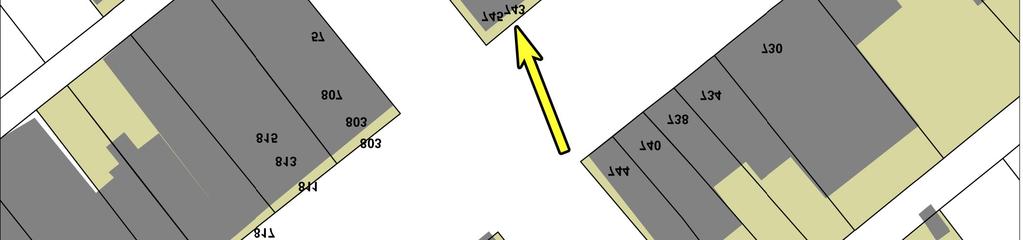
8 Page 8 of 9 Sketch Map


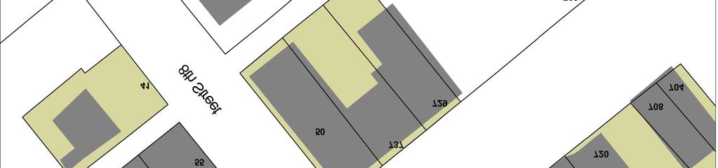
9 743/745 Lincoln Avenue 5RT.1022 Page 9 of 9 Location Map
Architectural Inventory Form
 COLORADO CULTURAL RESOURCE SURVEY Page 1 of 3 Official Eligibility Determination (OAHP use only) Rev. 9/98 OAHP1403 Date Initials Determined Eligible National Register Determined Not Eligible National
Architectural Inventory Form
 OAHP1403 Rev. 9/98 COLORADO CULTURAL RESOURCE SURVEY Architectural Inventory Form Official eligibility determination (OAHP use only) Date Initials Determined Eligible- NR Determined Not Eligible- NR Determined
NE¼ of NE¼ of NE¼ of NE¼ of section Roof configuration (enter one): Gabled Roof / Front Gabled Roof
: Gabled Roof / Front Gabled Roof") OAHP1403 Rev. 9/98 COLORADO CULTURAL RESOURCE SURVEY Official Eligibility Determination (OAHP use only) Date Initials Determined Eligible - National Register Architectural Inventory Form Determined Not
OAHP1403 Rev. 9/98 COLORADO CULTURAL RESOURCE SURVEY Official Eligibility Determination (OAHP use only) Date Initials Determined Eligible - National Register Architectural Inventory Form Determined Not
IMPORTANT NOTICE. Architectural Inventory Form COLORADO CULTURAL RESOURCE SURVEY I. IDENTIFICATION. 305 Eldorado Avenue 5BL.10471
 IMPORTANT NOTICE OAHP1403 Rev. 9/98 COLORADO CULTURAL RESOURCE SURVEY Architectural Inventory Form Page 1 This survey form represents an UNOFFICIAL COPY and is provided for informational purposes only.
301 7½ Street SW
 301 7½ Street SW 104-0213-0072 Primary Resource Information: Single Dwelling, Stories 2.00, Style: Other, ca 1890 July 2006: This late-19th-century, 3-bay, 2-story, hip-roofed frame I-house features projecting
THE BARNACLE 3485 MAIN HIGHWAY
 THE BARNACLE 3485 MAIN HIGHWAY Designation Report City of Miami REPORT OF THE CITY OF MIAMI PLANNING AND ZONING DEPARTMENT TO THE HISTORIC AND ENVIRONMENTAL PRESERVATION BOARD ON THE POTENTIAL DESIGNATION
FLAGLER WORKER S HOUSE FORT DALLAS PARK S.E. 4 STREET
 FLAGLER WORKER S HOUSE FORT DALLAS PARK 60-64 S.E. 4 STREET Designation Report City of Miami REPORT OF THE CITY OF MIAMI PLANNING DEPARTMENT TO THE HERITAGE CONSERVATION BOARD ON THE POTENTIAL DESIGNATION
HISTORIC SITE FORM HISTORIC SITES INVENTORY
 HISTORIC SITE FORM HISTORIC SITES INVENTORY 1 IDENTIFICATION Name of Property: House at 569 Park Avenue PARK CITY MUNICIPAL CORPORATION (10-08) Address: 569 Park Avenue City, County: Park City, Summit
808 Cherry Avenue
 808 Cherry Avenue 104-0213-0059 Primary Resource Information: Single Dwelling, Stories 2.00, Style: Other, ca 1900 July 2006: This 2-story, 3-bay frame I-house features a central-front gable, a brick pier
MAGIC CITY PARK NE 2 ND AVENUE
 MAGIC CITY PARK 6001 6005 NE 2 ND AVENUE Designation Report City of Miami REPORT OF THE CITY OF MIAMI PRESERVATION OFFICER TO THE HISTORIC AND ENVIRONMENTAL PRESERVATION BOARD ON THE POTENTIAL DESIGNATION
ADDENDUM. Chain of Title. Block C, Lot 8-9. Adrian I. Velthuis and Floyd T. Grant to Lottie Thompson
 Chain of Title Block C, Lot 8-9 NLP 5175:842 October 18, 1979 NLP 4979:58 October 5, 1977 NLP 4763:448 May 11, 1977 Adrian I. Velthuis and Floyd T. Grant to Lottie Thompson Gentlemens II Properties, Inc.,
STATEMENT OF SIGNIFICANCE
 STATEMENT OF SIGNIFICANCE The National Register of Historic Places identifies three concepts (are historic significance, historic context, and historic integrity) that are used to evaluate whether or not
National Register of Historic Places Continuation Sheet
 Section number N/A Page 1 Proposed Amendment to Wichita, Sedgwick County, Kansas The owner of the building at 141 S. Rock Island Avenue requests amendment to the boundaries of the East Douglas Historic
Town: Sharon Place (neighborhood or village): Sharon. ame of Area: Present Use: Date (month / year): July 2008
: Sharon. ame of Area: Present Use: Date (month / year): July 2008") FORM A - AREA MASSACHUSETTS HISTORICAL COMMISSION MASSACHUSETTS ARCHIVES BUILDING 220 MORRISSEY BOULEVARD BOSTON, MASSACHUSETTS 02125 Photograph Assessor s Sheets USGS Quad Area Letter Form Numbers in
FORM A - AREA MASSACHUSETTS HISTORICAL COMMISSION MASSACHUSETTS ARCHIVES BUILDING 220 MORRISSEY BOULEVARD BOSTON, MASSACHUSETTS 02125 Photograph Assessor s Sheets USGS Quad Area Letter Form Numbers in
September 13, Presented by: Jeremy Parsons PLANNING & ECONOMIC DEVELOPMENT DEPARTMENT
 Recommendation to Designate Property Located at 828 Sanatorium Road, Hamilton (Mountain Sanatorium Brow Campus) Under Part IV of the Ontario Heritage Act () September 13, 2018 Presented by: Jeremy Parsons
Hwy Retaining Wall/ Sea Wall. Not Eligible, see Statement of Significance Also member of listed NR district: Mantorville Historic District
 Historic Name CS # 2007 Other Name SHPO Inv # Location E and W sides of TH 57 between 6th St and 7th St Hwy District Reference City/Township County Mantorville, City of Dodge Acres Twp Rng Sec 107N 16W
1 Gildersleeve Wood (DHR # )
") GILDERSLEEVE WOOD 1 Gildersleeve Wood (DHR # 104-5092-0012) STREET ADDRESS: 1 Gildersleeve Wood MAP & PARCEL: 11-20 PRESENT ZONING: R-1U ORIGINAL OWNER: Lindsay Family ORIGINAL USE: PRESENT USE: PRESENT
GILDERSLEEVE WOOD 1 Gildersleeve Wood (DHR # 104-5092-0012) STREET ADDRESS: 1 Gildersleeve Wood MAP & PARCEL: 11-20 PRESENT ZONING: R-1U ORIGINAL OWNER: Lindsay Family ORIGINAL USE: PRESENT USE: PRESENT
 Page 1 Original Update HISTORICAL STRUCTURE FORM FLORIDA MASTER SITE FILE Consult Guide To Historical Structure Forms for detailed instructions Site # 8OR9844 Recorder # 26 Recorder Date 2/20/08 Site Name
STATE OF WASHINGTON ARCHAEOLOGICAL SITE INVENTORY FORM
 STATE OF WASHINGTON ARCHAEOLOGICAL SITE INVENTORY FORM Smithsonian Number: 45 County: Chelan Date: 6/12/2018 Human Remains? DAHP Case No.: Archaeological Sites are exempt from public disclosure per RCW
Commonwealth of Massachusetts Massachusetts Historical Commission 220 Morrissey Boulevard, Boston, Massachusetts
 Inventory No: Historic Name: Common Name: Address: HRV.165 Blood, Joseph House Farnsworth, Jonathan - Beaman, Jonathan House 74 Poor Farm Rd City/Town: Village/Neighborhood: Local No: 9-17 Year Constructed:
STATE OF IOWA. Historical and Architectural Survey for 2008 Flood Projects in Vinton, Benton County
 STATE OF IOWA CHESTER J. CULVER GOVERNOR PATTY JUDGE LT. GOVERNOR DEPARTMENT OF PUBLIC DEFENSE IOWA HOMELAND SECURITY AND EMERGENCY MANAGEMENT DIVISION DAVID L. MILLER, ADMINISTRATOR Historical and Architectural
Appendix E Historic Property Inventory Forms
 Appendix E Historic Property Inventory Forms TECHNICAL MEMORANDUM Sound Transit Federal Way Link Extension WISAARD Survey Entries PREPARED FOR: COPY TO: PREPARED BY: Sound Transit Alisa Swank/ CH2M MaryNell
Gilpin County Historic Preservation Advisory Commission. 114 Redtail Road Historic Eligibility Review
 Gilpin County Historic Preservation Advisory Commission 114 Redtail Road Historic Eligibility Review Deon Wolfenbarger Three Gables Preservation February 18, 2017 BACKGROUND The purpose of the review is
Village of Skokie Downtown Area Sign Guidelines. for CX Core Mixed Use Zoning District
 Village of Skokie Downtown Area Sign Guidelines for CX Core Mixed Use Zoning District January 2011 (c) 2011 Published by the Village of Skokie, 5127 W. Oakton Street, Skokie, Illinois 60077 Signs are important
United States Department of the Interior National Park Service. Boundary Expansion Listed in National Register January 11, 2017
 NPS Form 10900-a (Rev. 8/2002) OMB No. 10240018 United States Department of the Interior National Park Service Boundary Expansion Listed in National Register January 11, 2017 National Register of Historic
Total 1 Total. Current Functions (Enter categories from instructions) Materials (Enter categories from instructions)
 Materials (Enter categories from instructions)") Site Inventory Form State Inventory No. 29-00962 New Supplemental State Historical Society of Iowa Part of a district with known boundaries (enter inventory no.) 29-03685 (November 2005) Relationship:
Site Inventory Form State Inventory No. 29-00962 New Supplemental State Historical Society of Iowa Part of a district with known boundaries (enter inventory no.) 29-03685 (November 2005) Relationship:
DESIGNATION REPORT KENNEDY-BAKER-WALKER-SHERRILL HOUSE (1849) 9320 KINGSTON PIKE (CLT ) KNOXVILLE, TENNESSEE July 12, 2007
 9320 KINGSTON PIKE (CLT ) KNOXVILLE, TENNESSEE July 12, 2007") DESIGNATION REPORT KENNEDY-BAKER-WALKER-SHERRILL HOUSE (1849) 9320 KINGSTON PIKE (CLT 132-027) KNOXVILLE, TENNESSEE July 12, 2007 Description The Kennedy-Baker-Walker-Sherrill House is located on the south
DESIGNATION REPORT KENNEDY-BAKER-WALKER-SHERRILL HOUSE (1849) 9320 KINGSTON PIKE (CLT 132-027) KNOXVILLE, TENNESSEE July 12, 2007 Description The Kennedy-Baker-Walker-Sherrill House is located on the south
Current Functions (Enter categories from instructions) Materials (Enter categories from instructions)
 Materials (Enter categories from instructions)") Site Inventory Form State Inventory No. 92-00542 New Supplemental State Historical Society of Iowa Part of a district with known boundaries (enter inventory no.) 92-00349 (November 2005) Relationship:
Site Inventory Form State Inventory No. 92-00542 New Supplemental State Historical Society of Iowa Part of a district with known boundaries (enter inventory no.) 92-00349 (November 2005) Relationship:
Change dormers and main entry on the river side of the house. Site: 43 Riverbank Road, Block 10 Lot 3
 City of Burlington Historic Preservation Commission Meeting Minutes: December 2, 2015 The City of Burlington Historic Preservation Commission held its regular monthly meeting on Wednesday, December 2,
street & number: COUNTY ROUTE 3, HC-88, BOX 17 not for publication: N/A city/town: WHEELER vicinity: X state: WV county: WEBSTER code: 101 zip code:
 NPS Forn 10-900 OMB No. 10024-0018 (Oct. 1990) United States Department of the Interior National Park Service NATIONAL REGISTIR OF HISTORIC PLACES REGISTRATICN FCRX =========================================================---------=======
WILLIAM TRELOAR HOUSE
 WILLIAM TRELOAR HOUSE This report was written on July 3, 1984 1. Name and location of the property: The property known as the William Treloar House is located at 328 N. Brevard St. in Charlotte, NC. 2.
State Level Historic Documentation Report. John Blue Bridge Hampshire County
 State Level Historic Documentation Report State Project No. S314-28-22.27 Federal Project No. BR-0028(058)D John Blue Bridge Hampshire County Prepared by: Randy Epperly, Historian Department of Transportation
; * --.-.,., rj ; United States Department of the Interior \ ' '"] I National Park Service
![; * --.-.,., rj ; United States Department of the Interior \ ' '] I National Park Service](/thumbs/88/117765392.jpg "; * --.-.,., rj ; United States Department of the Interior \ ' '] I National Park Service") NPS Form 10-900 OMB No. 1024-0018 (Rev. 10-90) : / i' -_ :. - : ; ; * --.-.,., rj ; United States Department of the Interior \ ' '"] I National Park Service NATIONAL REGISTER OF HISTORIC PLACES REGISTRATION
NPS Form 10-900 OMB No. 1024-0018 (Rev. 10-90) : / i' -_ :. - : ; ; * --.-.,., rj ; United States Department of the Interior \ ' '"] I National Park Service NATIONAL REGISTER OF HISTORIC PLACES REGISTRATION
Maryland Historical Trust Inventory No. PG: 86A-026 Maryland Inventory of Historic Properties Form
 Inventory No. PG: 86A-026 Maryland Inventory of 1. Name of Property (indicate preferred name) historic other 2. Location street and number 12811 Croom Road not for publication city, town Naylor vicinity
Address 347 Whitney Street. East elevation, camera facing southwest.
 FORM B BUILDING Assessor s Number USGS Quad Area(s) Form Number MASSACHUSETTS HISTORICAL COMMISSION MASSACHUSETTS ARCHIVES BUILDING 220 MORRISSEY BOULEVARD BOSTON, MASSACHUSETTS 02125 Town Northborough
Historic Inventory Report
 Location Field Site No. 3394-134 DAHP No. Historic Name: Common Name: Cabinetrends Property Address: 24619 Pacific Hwy S, Kent, WA 98032 Comments: Tax No./Parcel No. 3601800165 Plat/Block/Lot Acreage.24
NPS Form OMB No Exp Status occupied X unoccupied work in progress Accessible yes: restricted yes: unrestricted _5Lno
 NPS Form 10-900 OMB No. 1024-0018 Exp. 10-31-84 United States Department of the Interior National Park Service National Register of Historic Places Inventory Nomination Form See instructions in How to
HERITAGE PROPERTY RESEARCH AND EVALUATION REPORT
 ATTACHMENT NO. 4 HERITAGE PROPERTY RESEARCH AND EVALUATION REPORT WILLIAM LUKE BUILDINGS 774 YONGE STREET, TORONTO Prepared by: Heritage Preservation Services City Planning Division City of Toronto March
RESIDENCE at 8238 NE 9 th Avenue And adjoining lot at 8220 NE9 th Avenue
 RESIDENCE at 8238 NE 9 th Avenue And adjoining lot at 8220 NE9 th Avenue Designation Report December 1, 2009 Historic and Environmental Preservation Board City of Miami NE 83RD ST --.- "1 r_, O~ J ru?
Historic Property Report
 Historic Name: Shadle Park Reservoir Property ID: 708465 Location Address: Location Comments: GeographicAreas: 4302 N Belt St, Spokane, Washington, USA Wellesley Ave & N Belt St Spokane,T25R42E01,SPOKANE
CITY OF MURFREESBORO HISTORIC ZONING COMMISSION. Regular Meeting June 19, :30 PM, Council Chambers, City Hall
 CITY OF MURFREESBORO HISTORIC ZONING COMMISSION Regular Meeting June 19, 2018 3:30 PM, Council Chambers, City Hall I. Call to Order and determination of a quorum II. Approve Minutes of the Regular Meeting
Proposed East Sanford Historic District DRAFT
 Proposed East Sanford Historic District DRAFT Inventory List The following inventory list provides basic information for all properties in the East Sanford Historic District. Included are each property
THE FORMER BRADBURY HALL, CHATSWORTH ROAD, CHESTERFIELD. GROUP LEADER, DEVELOPMENT MANAGEMENT
 AGENDA ITEM NO. 7 THE FORMER BRADBURY HALL, CHATSWORTH ROAD, CHESTERFIELD. MEETING: PLANNING COMMITTEE DATE: 17 TH MAY 2004 REPORT BY: WARD: COMMUNITY FORUM: GROUP LEADER, DEVELOPMENT MANAGEMENT HOLMEBROOK
Photo Album Intact/Slightly Altered. Eligible, see Statement of Significance. Roadside Development on Minnesota Trunk Highways,
 Historic Name CS # 5202 Other Name SHPO Inv # Location Hwy District Reference City/Township County Courtland Township Nicollet Acres 4.6 Twp Rng Sec 110N 30W Sec 22 Rest Area Class 4 USGS Quad UTM New
COLORADO HISTORICAL SOCIETY
 SECTION I COLORADO HISTORICAL SOCIETY OAHP1414 (Rev. 11/2001) COLORADO STATE REGISTER OF HISTORIC PROPERTIES NOMINATION FORM Name of Property Historic Name Boor Ranch/Boor Homestead Other Names Redmond
National Register of Historic Places Registration Form
 NPS Form 10-900 OMB No. 10024-0018 (Oct. 1990) United States Department of the Interior National Park Service National Register of Historic Places Registration Form 1. Name of Property historic name other
Friends Meeting House, Leicester. 16 Queens Road, Leicester, LE2 1WP. National Grid Reference: SK Statement of Significance
 Friends Meeting House, Leicester 16 Queens Road, Leicester, LE2 1WP National Grid Reference: SK 59852 02815 Statement of Significance A meeting house purpose-built on a new site in 1955 and slightly enlarged
National Register of Historic Places Inventory Nomination Form
 NPS Form 10-900-a Exp. 10-31-84 Continuation sheet 4 5 item number 7 Page 45 NAME: Knight Estate LOCATION: 486 East Avenue,,--v..u^-^ OWNER: State of Rhode Island Department of Education Board of Regents
Commonwealth of Massachusetts Massachusetts Historical Commission 220 Morrissey Boulevard, Boston, Massachusetts
 Inventory No: Historic Name: Common Name: Address: NWB.3010 Colonial Beacon Oil Company Shed Blue Frontier Yacht Services Office 115 Water St City/Town: Newburyport Village/Neighborhood: Local No: 20-10
MINNESOTA ARCHITECTURE - HISTORY INVENTORY FORM Property Location
 MINNESOTA ARCHITECTURE - HISTORY INVENTORY FORM ------ - Property Location -- ---- Property Name: Washington Park Address: 215 N 4th Street County: Blue Earth City/Twp: Mankato PIN: R01.09.07.461.001 Legal
RESEARCH AND EVALUATION SUMMARY: 297 AND 299 SHERBOURNE STREET
 ATTACHMENT NO. 6 RESEARCH AND EVALUATION SUMMARY: 297 AND 299 SHERBOURNE STREET William Elliott Houses: principal (west) elevations (Heritage Preservation Services, 2016) HISTORICAL CHRONOLOGY Key Date
Abandoned or Vacant; Agricultural; Camp; Other Residential Agriculture; Archaeology, Historic; Architecture; Politics Government; Social History
 Inventory No: Historic Name: HRV.G Civilian Conservation Camp Common Name: Address: City/Town: Village/Neighborhood: Local No: 13-7.01 Year Constructed: Architect(s): Architectural Style(s): Use(s): Significance:
Fletchertown (71A-022)
") Fletchertown (71A-022) Fletchertown is a late-nineteenth-century rural African-American community in northeastern Prince George s County. The community is located south of Huntington and northwest of Bowie.
Fletchertown (71A-022) Fletchertown is a late-nineteenth-century rural African-American community in northeastern Prince George s County. The community is located south of Huntington and northwest of Bowie.
BOARD OF ADJUSTMENT AGENDA
 BOARD OF ADJUSTMENT AGENDA February 28, 2018 I. Call to Order II. III. Approval of Minutes Old Business: 1. Coleman Bass Construction (VAR17-0112) Variance* 1800 NW Mystic Avenue Interior Side Setback
National Register of Historic Places Registration Form
 NPS Form 10-900 OMB No. 1024-0018 (Expires 5/31/2012) United States Department of the Interior National Register Listed National Park Service May 1, 2012 National Register of Historic Places Registration
ate: AR County: Pulaski Code: AR Zip Code: Noncontributing buildings sites structures objects Total
 Mims-Ereedlove-Priest-Weatherton House Name of Property Little Rock, AR County and State ~- -,s Form 10-900 'V. 8-86) OMB No. 1024-0018 United States Department of the Interior National Park Service NATIONAL
Architectural Inventory Form
 OAHP 1403 Rev. 9/98 COLORADO CULTURAL RESOURCE SURVEY Page 1 of 5 Official Eligibility Determination (OAHP Use Only) Date Initials Determined Eligibile-NR Determined Not Eligible-NR Determined Eligibile-SR
county Lonoke code 085 zip code
 ~~~~~~~~~~~ AR NPS Form I 0-900 (Oct. 1990) United States Department of the Interior National Park Service National Register of Historic Places egistration Form w-l.3-1 / OMB No. 10024-0018 This form is
COLORADO HISTORICAL SOCIETY COLORADO STATE REGISTER OF HISTORIC PROPERTIES NOMINATION FORM
 COLORADO HISTORICAL SOCIETY COLORADO STATE REGISTER OF HISTORIC PROPERTIES NOMINATION FORM OAHP1414 (Rev. 8/2003) SECTION I Name of Property Historic Name Other Names HUBBARD RANCH / TEN SLEEP RANCH /
Section 106 Update Memo #1 Attachment D. Traffic Diversion & APE Expansion Methodology & Maps
 Section 106 Update Memo #1 Attachment D Traffic Diversion & APE Expansion Methodology & Maps I-65/I-70 North Split Interchange Reconstruction Project (Des. Nos. 1592385 & 1600808) Traffic Diversion and
MINNESOTA HISTORIC.PROPERTIES INVENTORY FORM. Yes_ No X Restricted
 HISTORIC NAME: CURRENT NAME: LEGAL DESC.: MINNESOTA HISTORIC.PROPERTIES INVENTORY FORM Hartley Sugar Camp W % of Gov't. Lot 3 and T55, R24, Sec. 9 COUNTY: Itasca CITY/TWP.: Trout Lake Twp. ADDRESS: of
National Register of Historic Places Registration Form
 NPS Form 10-900 OMB No. 10024-0018 (Oct. 1990) Registration Form This form is for use in nominating or requesting determinations for individual properties and districts. See instructions in How to Complete
Schedule of Planning Applications Committee Date: 23 May Reference: 06/18/0064/F Great Yarmouth Officer: Mr J Beck Expiry Date:
 Schedule of Planning Applications Committee Date: 23 May 2018 Reference: 06/18/0064/F Great Yarmouth Officer: Mr J Beck Expiry Date: 24-04-2018 Applicant: Proposal: Site: Mr Mavroudis Clear weather hoardings
Maryland Historical Trust Inventory No. PG: 75A-007 Maryland Inventory of Historic Properties Form
 Inventory No. PG: 75A-007 Maryland Inventory of 1. Name of Property (indicate preferred name) historic other 2. Location street and number 3101 Ritchie Road not for publication city, town Forestville vicinity
D not for publication D vicinity
 NPS Fonn I 0-900 (Oct. 1990) OMB No. 10024-0018 United States Department of the Interior National Park Service National Register of Historic Places Registration Form This fom1 is for use in nominating
NEWBORO AND PORTLAND HARBOUR REDVELOPMENT PLANS
 INTRODUCTION The Municipal docks in both Newboro and Portland were transferred to the Township of Rideau Lakes by Parks Canada in 2002. Little has been done to improve the docks physical condition or role
Gilpin County Historic Preservation Advisory Commission. 104 Redtail Road Historic Eligibility Review
 Gilpin County Historic Preservation Advisory Commission 104 Redtail Road Historic Eligibility Review Deon Wolfenbarger Three Gables Preservation February 18, 2017 BACKGROUND The purpose of the review is
NPS Form OMB No (Oct. 1990)
") NPS Form 10-900 OMB No. 10024-0018 (Oct. 1990) United States Department of the Interior National Park Service NATIONAL REGISTER OF HISTORIC PLACES REGISTRATION FORM 1. Name of Property historic name:_lost
NPS Form 10-900 OMB No. 10024-0018 (Oct. 1990) United States Department of the Interior National Park Service NATIONAL REGISTER OF HISTORIC PLACES REGISTRATION FORM 1. Name of Property historic name:_lost
STAFF REPORT. Airport Land Use Consistency Determination Betteravia Plaza. MEETING DATE: January 21, 2016 AGENDA ITEM: 8D
 STAFF REPORT SUBJECT: Airport Land Use Consistency Determination Betteravia Plaza MEETING DATE: AGENDA ITEM: 8D STAFF CONTACT: Andrew Orfila RECOMMENDATION: Adopt findings for the Betteravia Plaza project
ri. Name historic: Oak Cliff United Methodist Church Date 7/17/97 and! or common:
 [ Dallas Landmark Landmark Nomination Commission Form ri. Name historic: Oak Cliff United Methodist Church Date 7/17/97 and! or common: L2. Location addresses: 541-49 E. Jefferson location! neighborhood:
East and north elevations, camera facing west. Condition Good
 FORM B BUILDING MASSACHUSETTS HISTORICAL COMMISSION MASSACHUSETTS ARCHIVES BUILDING 220 MORRISSEY BOULEVARD BOSTON, MASSACHUSETTS 02125 Assessor s Number USGS Quad Area(s) Form Number Town Northborough
DAMAGE ASSESSMENT OF SAND FENCING GARDEN CITY, NORTH LITCHFIELD AND LITCHFIELD BEACH GEORGETOWN COUNTY, SC
 OF SAND FENCING GARDEN CITY, NORTH LITCHFIELD AND LITCHFIELD BEACH GEORGETOWN COUNTY, SC June 07, 2017 PREPARED FOR: GEORGETOWN COUNTY DEPARTMENT OF PUBLIC SERVICES PREPARED BY: The EARTHWORKS Group 11655
National Register of Historic Places Registration Form
 National Park Service National Register of Historic Places Registration Form This form is for use in nominating or requesting determinations for individual properties and districts. See instructions in
AH pp. I Ti. Nov 7 I) I I y
 I I y") ..------------------------------------------ ------------ - - -- - NPS Form 10-900 (Rev. 8-86) United States Department of the Interior ~a tional Park Service NATIONAL REGISTER OF HISTORIC PLACES REGISTRATION
..------------------------------------------ ------------ - - -- - NPS Form 10-900 (Rev. 8-86) United States Department of the Interior ~a tional Park Service NATIONAL REGISTER OF HISTORIC PLACES REGISTRATION
IMPORTANT NOTICE. Architectural Inventory Form COLORADO CULTURAL RESOURCE SURVEY I. IDENTIFICATION Eldorado Avenue 5BL.10486
 IMPORTANT NOTICE OAHP1403 Rev. 9/98 COLORADO CULTURAL RESOURCE SURVEY Architectural Inventory Form Page 1 This survey form represents an UNOFFICIAL COPY and is provided for informational purposes only.
United States Department of the Interior National Park Service NATIONAL REGISTER OF HISTORIC PLACES REGISTRATION FORM. Wilmoth, Bernard E.
 NPS Form 10-900 OMB No. 10024-0018 (Oct. 1990) United States Department of the Interior National Park Service NATIONAL REGISTER OF HISTORIC PLACES REGISTRATION FORM 1. Name of Property historic name: other
UNITED STATES DEPARTMENT OF THE INTERIOR BUREAU OF LAND MANAGEMENT MANUAL TRANSMITTAL SHEET
 Form 1221-2 (June 1969) UNITED STATES DEPARTMENT OF THE INTERIOR BUREAU OF LAND MANAGEMENT MANUAL TRANSMITTAL SHEET Release 8-83 Date Subject 8353 Trail Management Areas Secretarially Designated (Public)
Maryland Historical Trust Inventory No. PG: Maryland Inventory of Historic Properties Form
 Inventory No. PG: 62-012 Maryland Inventory of 1. Name of Property (indicate preferred name) historic other 2. Location street and number 11205 Old Baltimore Pike not for publication city, town Beltsville
The meeting house is a converted Plymouth Brethren Chapel which originally was two cottages. It has medium significance.
 Quaker Meeting House, Ashburton Foales Court, off North Street, Ashburton, Devon, TQ13 7QE National Grid Reference: SX 75574 69951 Statement of Significance The meeting house is a converted Plymouth Brethren
NATIONAL REGISTER OF HISTORIC PLACES REGISTRATION FORM
 NPS Form 10-900 OMB No. 1024-0018 (Rev. 10-90) United States Department of the Interior National Park Service NATIONAL REGISTER OF HISTORIC PLACES REGISTRATION FORM 1. Name of Property historic name Compton-Johnson
29 Plas Derwen. Exploring Abergavenny
 29 Plas Derwen Exploring Abergavenny Cover: rhythm 2 plas derwen EXPLORING ABERGAVENNY For several years the Abergavenny and District Civic Society has been studying the streets, spaces and buildings of
URBAN DESIGN REPORT. Proposed Residential Development, Old Church Road, Caledon East
 Proposed Residential Development, Old Church Road, Caledon East TABLE CONTENTS: 1.0 DEVELOPMENT 1.1 Introduction-Analysis of Guiding Principles and Documents 1.2 Community Design and Architectural Design
RAY YENKANA Willowbrook Cr, Dawson Creek BC Canada $2,847,000
 1716 Willowbrook Cr, Dawson Creek BC Canada For SALE $2,847,000 This is a rare find, 32 townhomes in Dawson Creek, BC. Excellent investment in a single title multi family complex. Vendor has upgraded this
National Register of Historic Places Registration Form
 National Park Service National Register of Historic Places Registration Form This form is for use in nominating or requesting determinations for individual properties and districts. See instructions in
San Francisco Planning Department South Mission Historic Resources Survey Historic District Description
 and Lofts West side of Orange Alley between 25 th and 26 th Streets. Boundaries: West side of Orange Alley between 25 th and 26 th Streets (back lots with frontage on Valencia Street) Period of Significance:
United States Department of the Interior National Park Service NATIONAL REGISTER OF HISTORIC PLACES REGISTRATION FORM
 NPS Form 10-900 (Oct. 1990) OMB No. 10024-0018 United States Department of the Interior National Park Service NATIONAL REGISTER OF HISTORIC PLACES REGISTRATION FORM 1. DR JOHN C. IRONS RESIDENCE hlstoric
Our Lady and St Edward. Gordon Road, St Ann s, Nottingham NG3. National Grid Reference SK Statement of Importance
 Our Lady and St Edward Gordon Road, St Ann s, Nottingham NG3 National Grid Reference SK 586 409 Statement of Importance The rather unprepossessing exterior of the church contrasts with the reposeful and
NPS Form OMB No (Rev ) U. S. Department of the Interior Name of Property: Hungry Mother State Park Historic District
 U. S. Department of the Interior Name of Property: Hungry Mother State Park Historic District") NPS Form 10-900 OMB No. 1024-4018 (Rev. 10-90) U. S. Department of the Interior Name of Property: Location: 5. Classification Ownership of Property (Check as many boxes as apply) Category of Property (Check
NPS Form 10-900 OMB No. 1024-4018 (Rev. 10-90) U. S. Department of the Interior Name of Property: Location: 5. Classification Ownership of Property (Check as many boxes as apply) Category of Property (Check
MINUTES December 12, 2016 Historic Preservation Commission City of Batavia. Chair Hagemann; Vice-Chair Roller; Commissioners Bus, and Sherer
 MINUTES Historic Preservation Commission City of Batavia Please NOTE: These minutes are not a word-for-word transcription of the statements made at the meeting, nor intended to be a comprehensive review
Figure San Dimas Bonita at San Dimas Avenue (view looking west)
") The adjoining neighborhood has an eclectic assortment of building types and uses, including: the historically significant but not architecturally or visually noteworthy San Dimas Lemon Association Packing
The adjoining neighborhood has an eclectic assortment of building types and uses, including: the historically significant but not architecturally or visually noteworthy San Dimas Lemon Association Packing
STATEMENT OF SIGNIFICANCE
 1765 Columbia Avenue - Miners Union Hall Miners Hall 2012 Heritage Register - Building 1) Historical Name: Miners Union Hall 2) Common Name: Miners Hall 3) Address: 1765 Columbia Avenue 4) Date of Construction:
National Register of Historic Places Registration Form
 NPS Form 10-900 OMB No. 10024-0018 (Oct. 1990) United States Department of the Interior National Park Service National Register of Historic Places Registration Form 1. Name of Property historic name Hickory
FOREST FIRE LOOKOUT TOWERS OF THE ARAPAHO-ROOSEVELT NATIONAL FORESTS AND ROCKY MOUNTAIN NATIONAL PARK
 This site contains links to other Internet sites. These links are not endorsements of any products or services in such sites, and no information in such site has been endorsed or approved by the USDA Forest
THE CORPORATION OF THE TOWN OF NIAGARA-ON-THE-LAKE. BY-LAW NO (214 Four Mile Creek Road)
") THE CORPORATION OF THE TOWN OF NIAGARA-ON-THE-LAKE BY-LAW NO. 4807-15 (214 Four Mile Creek Road) A BY-LAW TO DESIGNATE THE PROPERTY KNOWN MUNICIPALLY AS WOODBOURNE, 214 FOUR MILE CREEK ROAD, IN THE TOWN
THE CORPORATION OF THE TOWN OF NIAGARA-ON-THE-LAKE BY-LAW NO. 4807-15 (214 Four Mile Creek Road) A BY-LAW TO DESIGNATE THE PROPERTY KNOWN MUNICIPALLY AS WOODBOURNE, 214 FOUR MILE CREEK ROAD, IN THE TOWN
THE FORMER GIRLS' HIGH SCHOOL IN MOSTAR A D A P T I V E R E - U S E P R O P O S A L F O R
 THE FORMER GIRLS' HIGH SCHOOL IN MOSTAR A D A P T I V E R E - U S E P R O P O S A L F O R A M A J O R P U B L I C B U I L D I N G I N T H E O L D C I T Y 1. INTRODUCTION Dr. Stefano Bianca, Director, Historic
The following criteria shall be applied within the boundaries of the AO District:
 Sec. 419 (a) Purpose AIRPORT OVERLAY DISTRICT (AO) The purpose of the Airport Overlay District is to regulate and restrict the height of structures, objects, or natural growth, regulate the locations of
WHANGANUI DISTRICT HERITAGE INVENTORY
 WHANGANUI DISTRICT HERITAGE INVENTORY Register Item No: 314 Type: Building Site: Pre-1900 Archaeological Interest Name: GRAND HOTEL Location: 99 St Hill Street (cnr Guyton Street), Whanganui Legal Description:
Draft proposed amendments. Chapter Terminology
 Draft proposed amendments Chapter 20.100 - Terminology 20.100.010 - General Terms The words and terms expressly defined in this chapter have the specific meanings assigned, unless the context expressly
Historical value The building was erected on a new site to serve a new meeting and in itself is of low historical value.
 Quaker Meeting House, Welwyn Garden City 109 Handside Lane, Welwyn Garden City, Hertfordshire, AL8 6SP National Grid Reference: TL 23149 12617 Statement of Significance As first built in 1926 to the designs
New Orleans Historic District Landmarks Commission Nomination Report 210 State Street, former NOAH Campus July 17, 2014
 New Orleans Historic District Landmarks Commission Nomination Report 210 State Street, former NOAH Campus July 17, 2014 Meeting Date: July 17, 2014 Property Address: Owner: 210 State Street Children s