Total 1 Total. Current Functions (Enter categories from instructions) Materials (Enter categories from instructions)
|
|
|
- Clarissa Byrd
- 5 years ago
- Views:
Transcription
1 Site Inventory Form State Inventory No New Supplemental State Historical Society of Iowa Part of a district with known boundaries (enter inventory no.) (November 2005) Relationship: Contributing Noncontributing Contributes to a potential district with yet unknown boundaries National Register Status:(any that apply) Listed De-listed NHL DOE 9-Digit SHPO Review & Compliance (R&C) Number Non-Extant (enter year) 1. historic name other names/site number Port of Burlington, Downtown Survey Map # DT Location street & number 400 N. Front city or town Burlington vicinity, county Legal Description: (If Rural) Township Name Township No. Range No. Section Quarter of Quarter (If Urban) Subdivision Original Block(s) Lot(s) Riverfront, Part NW, Section 4 3. State/Federal Agency Certification [Skip this Section] 4. National Park Service Certification [Skip this Section] 5. Classification Category of Property (Check only one box) Number of Resources within Property building(s) If Non-Eligible Property If Eligible Property, enter number of: district Enter number of: Contributing Noncontributing site buildings 1 buildings structure sites sites object structures structures objects objects Total 1 Total Name of related project report or multiple property study (Enter N/A if the property is not part of a multiple property examination). Title Historical Architectural Data Base Number Intensive Level Historical and Architectural Survey of East Downtown Burlington, IA Function or Use Historic Functions (Enter categories from instructions) Current Functions (Enter categories from instructions) 14C Transportation water related 14A Transportation - rail-related 02H Commerce - warehouse 7. Description Architectural Classification (Enter categories from instructions) 99 Other visitors center 02F02 Commerce - market place (farmers' market) 03A Social - meeting hall Materials (Enter categories from instructions) 09F Commercial side gable foundation 10B: concrete walls (visible material) roof 03 Tile block / 10B: concrete 08A: asphalt shingle other steel beam supports Narrative Description ( SEE CONTINUATION SHEETS, WHICH MUST BE COMPLETED) 8. Statement of Significance Applicable National Register Criteria (Mark x representing your opinion of eligibility after applying relevant National Register criteria) Yes No More Research Recommended A Property is associated with significant events. Yes No More Research Recommended B Property is associated with the lives of significant persons. Yes No More Research Recommended C Property has distinctive architectural characteristics. Yes No More Research Recommended D Property yields significant information in archaeology or history.
2 400 North Front Site Number Burlington District Number Criteria Considerations A Owned by a religious institution or used for religious purposes. B Removed from its original location. C A birthplace or grave. D A cemetery E A reconstructed building, object, or structure. F A commemorative property. G Less than 50 years of age or achieved significance within the past 50 years. Areas of Significance (Enter categories from instructions) Significant Dates Construction date 05: Commerce 1928 check if circa or estimated date Other dates, including renovation. 1975, 1987 Significant Person (Complete if National Register Criterion B is marked above) Architect/Builder Architect Builder Struchen-Romer Company (St. Paul, MN) Narrative Statement of Significance ( SEE CONTINUATION SHEETS, WHICH MUST BE COMPLETED) 9. Major Bibliographical References Bibliography See continuation sheet for citations of the books, articles, and other sources used in preparing this form 10. Geographic Data UTM References (OPTIONAL) Zone Easting Northing Zone Easting Northing See continuation sheet for additional UTM references or comments 11. Form Prepared By name/title Mary Toal, Volunteer; Angela Adams, Commission Member; Rebecca L. McCarley, consultant, Davenport organization Burlington Historic Preservation Commission date January 20, 2013 street & number Hall, 400 Washington Street telephone city or town Burlington state Iowa zip code ADDITIONAL DOCUMENTATION (Submit the following items with the completed form) FOR ALL PROPERTIES 1. Map: showing the property s location in a town/city or township. 2. Site plan: showing position of buildings and structures on the site in relation to public road(s). 3. Photographs: representative black and white photos. If the photos are taken as part of a survey for which the Society is to be curator of the negatives or color slides, a photo/catalog sheet needs to be included with the negatives/slides and the following needs to be provided below on this particular inventory site: Roll/slide sheet # Frame/slot # Date Taken Roll/slide sheet # Frame/slot # Date Taken Roll/slide sheet # Frame/slot # Date Taken See continuation sheet or attached photo & slide catalog sheet for list of photo roll or slide entries. Photos/illustrations without negatives are also in this site inventory file. FOR CERTAIN KINDS OF PROPERTIES, INCLUDE THE FOLLOWING AS WELL 1. Farmstead & District: (List of structures and buildings, known or estimated year built, and contributing or noncontributing status) 2. Barn: a. A sketch of the frame/truss configuration in the form of drawing a typical middle bent of the barn. b. A photograph of the loft showing the frame configuration along one side. c. A sketch floor plan of the interior space arrangements along with the barn s exterior dimensions in feet. State Historic Preservation Office (SHPO) Use Only Below This Line Concur with above survey opinion on National Register eligibility: Yes No More Research Recommended This is a locally designated property or part of a locally designated district. Comments: Evaluated by (name/title): Date:
3 Page 1 7. Narrative Description This one-story concrete and tile block building built in 1928 as the for the Port of Burlington. It was originally built over the river on concrete piers, with riverfront improvements in the 1950s and 1960s extending the edge of the bank further out into the river. The building was rehabilitated into a visitors center in 1976, and further work to develop the property occurred in Further development of the riverfront area from this building south to the auditorium filled in a significant portion of the land and created a plaza and riverwalk area along the river. Thus, the concrete piers of this building are now underground, with sidewalk and plaza extending along the east side of the building as well. However, the Mississippi River remains the key feature of the east side of the building, as historically was functional for this side. The building has a low pitch gable roof, which runs parallel to the river and to Front Street. The west side of the building retains its wide metal canopy supported by cables above the roof over the former railroad loading area. A concrete platform along this side provides access to the interior of the building. Large openings remain on the north and south ends of this side, with the center sections having pedestrian doors and double-hung windows. The north side has two large windows. The south side has two large windows as well, with a concrete stage area built to address the riverfront development to the south. The east side retains a glass enclosed extension from the center of the building, historically the connection to the loading barge floating on the Mississippi River. The fill along this side of the building has resulted in concrete sidewalks, river viewing area, and other landscaping. 8. Narrative Statement of Significance The appears to contribute historically to the potential Downtown Commercial Historic District. The recommended boundary for the historic district extends east to the Mississippi River to incorporate this building in the historic district. The building is significantly related to the commercial activities in Burlington from its completion in 1928 through the middle of the 20 th century and into the 1970s. The construction of the river terminal provided Burlington with modern docks to serve their local businesses and provide a modern transportation connection between the river and their many railroad lines. The also appears to be individually eligible for listing on the National Register of Historic Places under Criterion A for this significant history in the history of commerce in Burlington. The building may also be individually eligible under Criterion C for its architecture as a river terminal (or port) building, a fairly rare type of building in Iowa. Further assessment of the integrity of the building and current relationship of the building with the river would solidify this determination. The historic transportation corridor, the Mississippi River, was improved in 1928 with the construction of a modern dock that met federal standards for barge traffic. In 1928, Congress authorized a fleet of 45 barges and five towboats for Federal Barge Line trade, boosting river traffic. In order to participate, Burlington needed a modern dock. A special election approved the dock, and construction started in early Contract for the municipal river terminal was let to Struchen-Romer Company of St. Paul,
4 Page 2 Minnesota. The building was situated on the levee across from Drake Hardware in the 400 block of N. Front Street (State # ). It was constructed on pylons, allowing the river to flow underneath it. Over 300 prominent people were noted to be in town for the October 10, 1928 dedication, which included an elaborate parade down Jefferson and a grand banquet. The municipal river terminal was leased to Inland Waterways Corp of New Orleans, which handled soap, coffee, sugar, household goods, furniture, peat moss, canned goods, farm machinery, and condensed milk in first year ( Thousands are Expected Here for Ceremony, Hawk-Eye, October 10, 1928, 1; Burlington was in need of dock and it got one, Burlington Hawk-Eye, July 10, 1962, 80). The 1930 Sanborn map shows the completed Municipal Docks operated by the Inland Waterways Corporation. The building was divided into two large spaces on the south half and a large warehouse on the north half. The map notes it has a concrete floor and sits on concrete piers with a steel frame. A platform extends along the west side with three railroad siding immediately in front of the building for loading. A floating walkway connects the main building to a loading barge to the east, which appears permanently attached to this side. The building and attached barge are depicted in historic photographs as well. In 1930, Burlington promoted itself with slogans such as Port of Burlington and On the Mississippi reinforcing its connection with the river and new municipal river terminal. The modern docks and warehouses provided ease of transfer of goods to the excellent railroad system and paved road system serving Burlington, providing distribution of goods throughout the country (McCoy s Burlington Directory 1930: 7). directories over the next decade continued to tout the benefit of the Port of Burlington, or the Mississippi River Terminal, for businesses in Burlington and commerce throughout the region. The Federal Barge Line connected Burlington and southern ports, and Burlington offered outstanding railroad connections to points to the east and west. With modern river and rail terminals, Burlington offered joint barge-and-rail rates for a savings in transportation costs for any shipper (McCoy s Burlington Directory 1935: 7). The Hawk-Eye Gazette noted the key transportation benefits of Burlington in 1938: Paved highways lead into Burlington from all points of the compass. A modern river terminal handles freight to and from the government-operated Upper Mississippi barge line. An important railroad center, the city has the largest shops of the Burlington railroad; streamlined trains operate though the city over that system, and rail service also is provided by the Rock Island lines. Coast-to-coast buses provide other means of travel, and Burlington municipal airport is on the Chicago-Kansas federal air route ( Burlington on the Misssissippi! Daily Hawk-Eye Gazette, September 2, 1938, 19). The Burlington River Terminal Building is listed among the public buildings in town in the 1940 city directory. Another improvement along the old levee was undertaken in with the construction of Memorial Auditorium, two blocks to the south in the 200 block of N. Front Street. The overall development of downtown Burlington and the riverfront area is depicted on a 1941 aerial photograph, which shows the area looking west from the Mississippi River. The railroad tracks enter at the lower left corner, with major lines continuing west-northwest to the top of the image and minor lines continuing north along the river at the bottom. The development of the riverfront area includes the construction of Memorial Auditorium between Valley and Jefferson, with parking to the south. Some fill appears added to the north to the building. This building appears to extend out over the Mississippi River on pylons, with the loading barge visible as well.
5 Page 3 directories list the Building at the foot of Washington Street through the 1940s and 1950s. The Federal Barge Line also continues to be listed here in the 1940s. Burlington Warehouse Corporation and Burlington-Chicago Cartage also have listings here in 1947 and Churchill Truck Lines also operated here per the 1950s city directories. By 1960, it is listed as the Mississippi River Terminal, with Sturm Freightways providing the terminal manager (Robert Easton). The river terminal building and new 1944 railroad station continue to be promoted in city directories through the 1940s, 1950s, and into the 1960s as key in the transportation connections for businesses in the community and surrounding area. The 1960 city directory notes that Burlington is served by the Chicago, Burlington, and Quincy (CB&Q) Burlington Route and the Chicago, Rock Island, & Pacific, with the railroads served by the Indiana limestone railroad station. Burlington also had waterway terminals on Mississippi River, and it had the only municipal terminal between Quad Cities and St. Louis. Additionally, the town boasted an excellent airport and hard surface highways in every direction. The result was first class transportation and shipping facilities. Freight rates on river were also very favorable due to breaking point between Official and Western Classifications (Polk s Burlington Directory 1960: VIII). Further improvements on the riverfront were undertaken in the 1960s. In January 1961, city council announced their plans to fill the area on the river front between Burlington Memorial Auditorium and Municipal Docks Terminal distance of about 360 feet and to surface it for parking (Hawk-Eye, January 31, 1961, 22). The river terminal was noted in 1962 as leased by Sturm Freightways Co since River business continued to be brisk, and the company dealt in grain, sugar, wire, coal, petroleum products, and other commodities (Burlington Hawk-Eye, July 10, 1962, 80). Plans to develop the riverfront were revived in 1972 with a new plan to develop more public uses from Memorial Auditorium north to Paul s Marina, including a new use for the municipal terminal building. The plan was presented to council in January 1974 and further developed in Sturm Freightways Company had leased the municipal terminal since 1953, and they vacated the facility in May The building was then rehabilitated into a visitors center in 1975 named the Port of Burlington as part of the riverfront improvement project ( Planning for riverfront improvement, Hawk-Eye, April 8, 1975, 4). Phase 1 of the work included the interior modifications and improvements for the conversion of the facility. This work included electrical work, heating, plumbing for restrooms, and new front and back doors on the building. The interior walls were left intact to preserve the historic division of the building into three spaces. Plans for the work were announced in November 1975, with work completed by spring Plans for a plaza area between the Port and Memorial Auditorium were being discussed as a future project ( Inside work is first phase of Port project, Hawk-Eye, November 13, 1975, 2). Planning and fundraising for additional work to improve the visitors center then occurred in 1986, with the work being completed in The State of Iowa announced plans for a Welcome Center in Burlington, and in 1988 the center opened here. A stage was constructed on the south side also in spring The Port of Burlington Welcome Center achieved the State of Iowa's "Primary Welcome Center Status" in The Port of Burlington is now a hub of activity all year around. The Port of
6 Page 4 Burlington Welcome Center has vast amounts of information on this area as well as the rest of the state. A scenic plaza area on the east side of the Port showcases the Mississippi riverfront. A community room for meetings and parties and a sheltered area for community events and other functions also are found here. An outdoor stage located at the south end of the building is the site of Burlington Steamboat Days American Music Festival, which attracts crowds in excess of 100,000 visitors every third week in June ( 9. Major Bibliographical References Directories, Burlington, Iowa, various dates. On microfiche at the Burlington Public Library Deed records, per transfer books at Auditor s Office. Downtown Partners, Inc., a Division of the Greater Burlington Partnership, Burlington, Iowa. Collection of collected historic photographs of downtown Burlington. Hass-McFadden. Aerial photograph of Burlington looking west from Mississippi River. In collection of and displayed at Burlington Public Library. Burlington, Iowa: Hass-McFadden, Newspapers, various titles and editions. Particular special editions utilized: Daily Hawk-Eye Gazette, September 2, 1938 Burlington Hawk-Eye Gazette, August 4, 1942 Burlington Hawk-Eye, July 10, 1962 Burlington Hawk-Eye, July 4, 1976 Sanborn Map Company. Burlington, Iowa, Fire Insurance Maps. New York: Sanborn Map Company, 1886, 1892, 1900, 1931, Smith, Claudia, and Marie Landon survey of sites in Burlington. Iowa Site Inventory forms prepared on file at State Historic Preservation Office,, IA. Vertical files. Files on business/industry as well as individual businesses. Burlington Public Library, Burlington, Iowa.


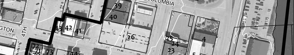
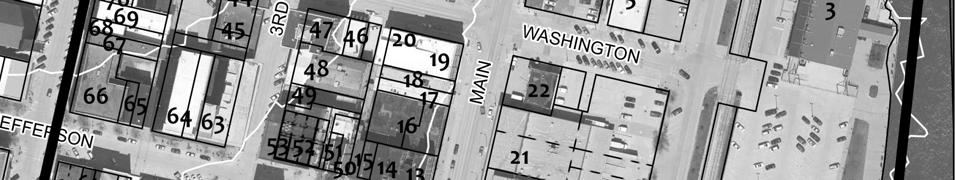
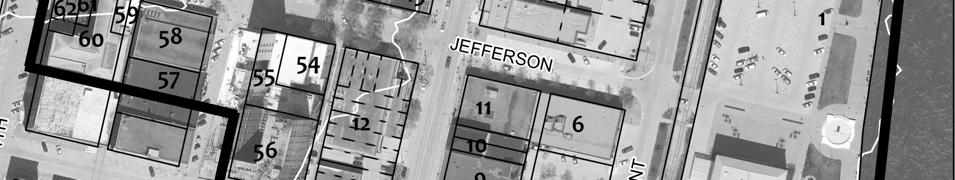
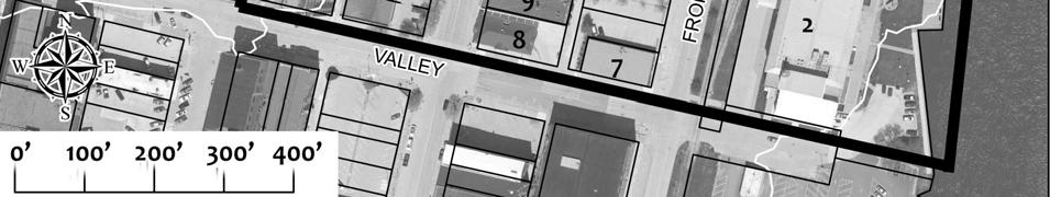
7 Page 5 Location map Base aerial photography by Aerial Services Inc for GIS Commission, March 2010.

8 Page 6 Building plan (from assessor s website)
9 Page 7 Historic images 1930 Sanborn map of riverfront area and downtown (Sanborn Map Company 1931).
10 Page aerial photograph of riverfront area and building (Hass-McFadden 1941)
11 Page Sanborn map of riverfront area and downtown (Sanborn Map Company 1931).


12 Page 10 around 1940 (Downtown Partners collection). in 1940s (Downtown Partners collection).
13 Page 11 around 1956 (Downtown Partners collection).

14 Page 12 Hawk-Eye, April 15, 3A

15 Page 13 Digital photographs Photograph West and south elevations, looking northeast (McCarley, November 15, 2012)

16 Page 14 Photograph North and west elevations, looking southeast (McCarley, November 15, 2012)

17 Page 15 Photograph Detail of west elevation, looking northeast (McCarley, November 15, 2012)

18 Page 16 Photograph South and east elevations, looking northwest (McCarley, June 20, 2012)
Current Functions (Enter categories from instructions) Materials (Enter categories from instructions)
 Materials (Enter categories from instructions)") Site Inventory Form State Inventory No. 92-00542 New Supplemental State Historical Society of Iowa Part of a district with known boundaries (enter inventory no.) 92-00349 (November 2005) Relationship:
Site Inventory Form State Inventory No. 92-00542 New Supplemental State Historical Society of Iowa Part of a district with known boundaries (enter inventory no.) 92-00349 (November 2005) Relationship:
Total 1 Total. Current Functions (Enter categories from instructions) 01D04: hotel 01B02: apartment building
 01D04: hotel 01B02: apartment building") Site Inventory Form State Inventory No. 29-00093 New Supplemental State Historical Society of Iowa Part of a district with known boundaries (enter inventory no.) 29-03685 (November 2005) Relationship:
Site Inventory Form State Inventory No. 29-00093 New Supplemental State Historical Society of Iowa Part of a district with known boundaries (enter inventory no.) 29-03685 (November 2005) Relationship:
Total 1 Total. Current Functions (Enter categories from instructions) 02G04 tavern. 02G01 Café/diner. Materials (Enter categories from instructions)
 02G04 tavern. 02G01 Café/diner. Materials (Enter categories from instructions)") Site Inventory Form State Inventory No. 29-01252 New Supplemental State Historical Society of Iowa Part of a district with known boundaries (enter inventory no.) (November 2005) Relationship: Contributing
Site Inventory Form State Inventory No. 29-01252 New Supplemental State Historical Society of Iowa Part of a district with known boundaries (enter inventory no.) (November 2005) Relationship: Contributing
city or town Muscatine vicinity, county Muscatine Legal Description: (If Rural) Township Name Township No. Range No. Section Quarter of Quarter
 Township Name Township No. Range No. Section Quarter of Quarter") Site Inventory Form State Inventory No. 70-00233 New Supplemental State Historical Society of Iowa Part of a district with known boundaries (enter inventory no.) (December 1, 1999) Relationship: Contributing
Site Inventory Form State Inventory No. 70-00233 New Supplemental State Historical Society of Iowa Part of a district with known boundaries (enter inventory no.) (December 1, 1999) Relationship: Contributing
Current Functions (Enter categories from instructions) Materials (Enter categories from instructions)
 Materials (Enter categories from instructions)") Site Inventory Form State Inventory No. 92-00538 New Supplemental State Historical Society of Iowa Part of a district with known boundaries (enter inventory no.) 92-00349 (November 2005) Relationship:
Site Inventory Form State Inventory No. 92-00538 New Supplemental State Historical Society of Iowa Part of a district with known boundaries (enter inventory no.) 92-00349 (November 2005) Relationship:
W. Third St. (also ) originally at W. Third St
 originally at W. Third St") Site Inventory Form State Inventory No. 70-00203 New Supplemental State Historical Society of Iowa Part of a district with known boundaries (enter inventory no.) (December 1, 1999) Relationship: Contributing
Site Inventory Form State Inventory No. 70-00203 New Supplemental State Historical Society of Iowa Part of a district with known boundaries (enter inventory no.) (December 1, 1999) Relationship: Contributing
Site Inventory Form State Inventory No New Supplemental
 Site Inventory Form State Inventory No. 70-00939 New Supplemental State Historical Society of Iowa Part of a district with known boundaries (enter inventory no.) (December 1, 1999) Relationship: Contributing
Downtown Commercial Historic District
 Site Inventory Form State Inventory No. 29-03685 New Supplemental State Historical Society of Iowa Part of a district with known boundaries (enter inventory no.) (November 2005) Relationship: Contributing
 Page 1 Original Update HISTORICAL STRUCTURE FORM FLORIDA MASTER SITE FILE Consult Guide To Historical Structure Forms for detailed instructions Site # 8OR9844 Recorder # 26 Recorder Date 2/20/08 Site Name
Richard Musser Mansion, West Lawn Terrace, Field Site #: WH-083
 Site Inventory Form State Inventory No. 70-00227 New Supplemental State Historical Society of Iowa Part of a district with known boundaries (enter inventory no.) (December 1, 1999) Relationship: Contributing
National Register of Historic Places Registration Form
 NPS Form 10-900 OMB No. 10024-0018 (Oct. 1990) Registration Form This form is for use in nominating or requesting determinations for individual properties and districts. See instructions in How to Complete
State Level Historic Documentation Report. John Blue Bridge Hampshire County
 State Level Historic Documentation Report State Project No. S314-28-22.27 Federal Project No. BR-0028(058)D John Blue Bridge Hampshire County Prepared by: Randy Epperly, Historian Department of Transportation
city or town Muscatine vicinity, county Muscatine Legal Description: (If Rural) Township Name Township No. Range No. Section Quarter of Quarter
 Township Name Township No. Range No. Section Quarter of Quarter") Site Inventory Form State Inventory No. 70-00182 & 70-00183 New Supplemental State Historical Society of Iowa Part of a district with known boundaries (enter inventory no.) (December 1, 1999) Relationship:
Site Inventory Form State Inventory No. 70-00182 & 70-00183 New Supplemental State Historical Society of Iowa Part of a district with known boundaries (enter inventory no.) (December 1, 1999) Relationship:
National Register of Historic Places Registration Form
 National Park Service National Register of Historic Places Registration Form This form is for use in nominating or requesting determinations for individual properties and districts. See instructions in
National Register of Historic Places Registration Form
 National Park Service National Register of Historic Places Registration Form This form is for use in nominating or requesting determinations for individual properties and districts. See instructions in
NE¼ of NE¼ of NE¼ of NE¼ of section Roof configuration (enter one): Gabled Roof / Front Gabled Roof
: Gabled Roof / Front Gabled Roof") OAHP1403 Rev. 9/98 COLORADO CULTURAL RESOURCE SURVEY Official Eligibility Determination (OAHP use only) Date Initials Determined Eligible - National Register Architectural Inventory Form Determined Not
OAHP1403 Rev. 9/98 COLORADO CULTURAL RESOURCE SURVEY Official Eligibility Determination (OAHP use only) Date Initials Determined Eligible - National Register Architectural Inventory Form Determined Not
street & number: COUNTY ROUTE 3, HC-88, BOX 17 not for publication: N/A city/town: WHEELER vicinity: X state: WV county: WEBSTER code: 101 zip code:
 NPS Forn 10-900 OMB No. 10024-0018 (Oct. 1990) United States Department of the Interior National Park Service NATIONAL REGISTIR OF HISTORIC PLACES REGISTRATICN FCRX =========================================================---------=======
; * --.-.,., rj ; United States Department of the Interior \ ' '"] I National Park Service
![; * --.-.,., rj ; United States Department of the Interior \ ' '] I National Park Service](/thumbs/88/117765392.jpg "; * --.-.,., rj ; United States Department of the Interior \ ' '] I National Park Service") NPS Form 10-900 OMB No. 1024-0018 (Rev. 10-90) : / i' -_ :. - : ; ; * --.-.,., rj ; United States Department of the Interior \ ' '"] I National Park Service NATIONAL REGISTER OF HISTORIC PLACES REGISTRATION
NPS Form 10-900 OMB No. 1024-0018 (Rev. 10-90) : / i' -_ :. - : ; ; * --.-.,., rj ; United States Department of the Interior \ ' '"] I National Park Service NATIONAL REGISTER OF HISTORIC PLACES REGISTRATION
Architectural Inventory Form
 OAHP1403 Rev. 9/98 COLORADO CULTURAL RESOURCE SURVEY Architectural Inventory Form Official eligibility determination (OAHP use only) Date Initials Determined Eligible- NR Determined Not Eligible- NR Determined
NPS Form OMB No (Oct. 1990)
") NPS Form 10-900 OMB No. 10024-0018 (Oct. 1990) United States Department of the Interior National Park Service NATIONAL REGISTER OF HISTORIC PLACES REGISTRATION FORM 1. Name of Property historic name:_lost
NPS Form 10-900 OMB No. 10024-0018 (Oct. 1990) United States Department of the Interior National Park Service NATIONAL REGISTER OF HISTORIC PLACES REGISTRATION FORM 1. Name of Property historic name:_lost
1. Name of Property. historic name Register Building. other names/site number. 2. Location
 Site Inventory Form State Inventory No. 22-00247 New Supplemental State Historical Society of Iowa Part of a district with known boundaries (enter inventory no.) 22-01381 (December 1, 1999) Relationship:
National Register of Historic Places Registration Form
 NPS Form 10-900 OMB No. 1024-0018 (Expires 5/31/2012) United States Department of the Interior National Register Listed National Park Service May 1, 2012 National Register of Historic Places Registration
STATE OF IOWA. Historical and Architectural Survey for 2008 Flood Projects in Vinton, Benton County
 STATE OF IOWA CHESTER J. CULVER GOVERNOR PATTY JUDGE LT. GOVERNOR DEPARTMENT OF PUBLIC DEFENSE IOWA HOMELAND SECURITY AND EMERGENCY MANAGEMENT DIVISION DAVID L. MILLER, ADMINISTRATOR Historical and Architectural
FLAGLER WORKER S HOUSE FORT DALLAS PARK S.E. 4 STREET
 FLAGLER WORKER S HOUSE FORT DALLAS PARK 60-64 S.E. 4 STREET Designation Report City of Miami REPORT OF THE CITY OF MIAMI PLANNING DEPARTMENT TO THE HERITAGE CONSERVATION BOARD ON THE POTENTIAL DESIGNATION
United States Department of the Interior National Park Service. Boundary Expansion Listed in National Register January 11, 2017
 NPS Form 10900-a (Rev. 8/2002) OMB No. 10240018 United States Department of the Interior National Park Service Boundary Expansion Listed in National Register January 11, 2017 National Register of Historic
National Register of Historic Places Multiple Property Documentation Form
 NPS Form 10-900-b OMB No. 1024-0018 Revised Aug. 2002 Expires 12-31-2005 Multiple Property Documentation Form This form is for use in documenting multiple property groups relating to one or several contexts.
HISTORIC SITE FORM HISTORIC SITES INVENTORY
 HISTORIC SITE FORM HISTORIC SITES INVENTORY 1 IDENTIFICATION Name of Property: House at 569 Park Avenue PARK CITY MUNICIPAL CORPORATION (10-08) Address: 569 Park Avenue City, County: Park City, Summit
Architectural Inventory Form
 COLORADO CULTURAL RESOURCE SURVEY Page 1 of 3 Official Eligibility Determination (OAHP use only) Rev. 9/98 OAHP1403 Date Initials Determined Eligible National Register Determined Not Eligible National
Maryland Historical Trust Inventory No. 15/6 Maryland Inventory of Historic Properties Form
 Inventory No. 15/6 Maryland Inventory of 1. Name of Property (indicate preferred name) historic Becraft Farm other 2. Location street and number 28500 Ridge Road not for publication city, town Mount Airy
Address 347 Whitney Street. East elevation, camera facing southwest.
 FORM B BUILDING Assessor s Number USGS Quad Area(s) Form Number MASSACHUSETTS HISTORICAL COMMISSION MASSACHUSETTS ARCHIVES BUILDING 220 MORRISSEY BOULEVARD BOSTON, MASSACHUSETTS 02125 Town Northborough
Architectural Inventory Form
 COLORADO CULTURAL RESOURCE SURVEY Page 1 of 3 Official Eligibility Determination (OAHP use only) Rev. 9/98 OAHP1403 Date Initials Determined Eligible National Register Determined Not Eligible National
National Register of Historic Places Registration Form
 NPS Form 10-900 (Oct. 1990) OMB No. 10024-0018 United States Department of the Interior 'fonal Park Service National Register of Historic Places Registration Form This form is for use in nominating or
Historic Property Report
 Historic Name: Shadle Park Reservoir Property ID: 708465 Location Address: Location Comments: GeographicAreas: 4302 N Belt St, Spokane, Washington, USA Wellesley Ave & N Belt St Spokane,T25R42E01,SPOKANE
MAGIC CITY PARK NE 2 ND AVENUE
 MAGIC CITY PARK 6001 6005 NE 2 ND AVENUE Designation Report City of Miami REPORT OF THE CITY OF MIAMI PRESERVATION OFFICER TO THE HISTORIC AND ENVIRONMENTAL PRESERVATION BOARD ON THE POTENTIAL DESIGNATION
National Register of Historic Places Registration Form
 NPS Form 10-900 OMB No. 1024-0018 (Expires 5/31/2012) United States Department of the Interior National Register Listed National Park Service May 1, 2012 National Register of Historic Places Registration
ate: AR County: Pulaski Code: AR Zip Code: Noncontributing buildings sites structures objects Total
 Mims-Ereedlove-Priest-Weatherton House Name of Property Little Rock, AR County and State ~- -,s Form 10-900 'V. 8-86) OMB No. 1024-0018 United States Department of the Interior National Park Service NATIONAL
Appendix E Historic Property Inventory Forms
 Appendix E Historic Property Inventory Forms TECHNICAL MEMORANDUM Sound Transit Federal Way Link Extension WISAARD Survey Entries PREPARED FOR: COPY TO: PREPARED BY: Sound Transit Alisa Swank/ CH2M MaryNell
Maryland Historical Trust Inventory No. PG: 86A-026 Maryland Inventory of Historic Properties Form
 Inventory No. PG: 86A-026 Maryland Inventory of 1. Name of Property (indicate preferred name) historic other 2. Location street and number 12811 Croom Road not for publication city, town Naylor vicinity
D not for publication D vicinity
 NPS Fonn I 0-900 (Oct. 1990) OMB No. 10024-0018 United States Department of the Interior National Park Service National Register of Historic Places Registration Form This fom1 is for use in nominating
Change dormers and main entry on the river side of the house. Site: 43 Riverbank Road, Block 10 Lot 3
 City of Burlington Historic Preservation Commission Meeting Minutes: December 2, 2015 The City of Burlington Historic Preservation Commission held its regular monthly meeting on Wednesday, December 2,
MINNESOTA HISTORIC.PROPERTIES INVENTORY FORM. Yes_ No X Restricted
 HISTORIC NAME: CURRENT NAME: LEGAL DESC.: MINNESOTA HISTORIC.PROPERTIES INVENTORY FORM Hartley Sugar Camp W % of Gov't. Lot 3 and T55, R24, Sec. 9 COUNTY: Itasca CITY/TWP.: Trout Lake Twp. ADDRESS: of
Mankato s Transportation Heritage
 Mankato s Transportation Heritage City of Mankato Mankato Heritage Preservation Commission May 11, 2017 1. Union Depot, 112 S. Riverfront Drive, c. 1896. The railroads were Mankato s dominant transportation
Commonwealth of Massachusetts Massachusetts Historical Commission 220 Morrissey Boulevard, Boston, Massachusetts
 Inventory No: Historic Name: Common Name: Address: HRV.165 Blood, Joseph House Farnsworth, Jonathan - Beaman, Jonathan House 74 Poor Farm Rd City/Town: Village/Neighborhood: Local No: 9-17 Year Constructed:
National Register of Historic Places Continuation Sheet
 Section number N/A Page 1 Proposed Amendment to Wichita, Sedgwick County, Kansas The owner of the building at 141 S. Rock Island Avenue requests amendment to the boundaries of the East Douglas Historic
NPS Form OMB No Exp Status occupied X unoccupied work in progress Accessible yes: restricted yes: unrestricted _5Lno
 NPS Form 10-900 OMB No. 1024-0018 Exp. 10-31-84 United States Department of the Interior National Park Service National Register of Historic Places Inventory Nomination Form See instructions in How to
THE BARNACLE 3485 MAIN HIGHWAY
 THE BARNACLE 3485 MAIN HIGHWAY Designation Report City of Miami REPORT OF THE CITY OF MIAMI PLANNING AND ZONING DEPARTMENT TO THE HISTORIC AND ENVIRONMENTAL PRESERVATION BOARD ON THE POTENTIAL DESIGNATION
Town: Sharon Place (neighborhood or village): Sharon. ame of Area: Present Use: Date (month / year): July 2008
: Sharon. ame of Area: Present Use: Date (month / year): July 2008") FORM A - AREA MASSACHUSETTS HISTORICAL COMMISSION MASSACHUSETTS ARCHIVES BUILDING 220 MORRISSEY BOULEVARD BOSTON, MASSACHUSETTS 02125 Photograph Assessor s Sheets USGS Quad Area Letter Form Numbers in
FORM A - AREA MASSACHUSETTS HISTORICAL COMMISSION MASSACHUSETTS ARCHIVES BUILDING 220 MORRISSEY BOULEVARD BOSTON, MASSACHUSETTS 02125 Photograph Assessor s Sheets USGS Quad Area Letter Form Numbers in
Appendix D Reevaluation of Structures on Bock House Property
 Appendix D Reevaluation of Structures on Bock House Property Page 1 Original Update HISTORICAL STRUCTURE FORM FLORIDA MASTER SITE FILE Consult Guide To Historical Structure Forms for detailed instructions
United States Department of the Interior National Park Service NATIONAL REGISTER OF HISTORIC PLACES REGISTRATION FORM
 NPS Form 10-900 (Oct. 1990) OMB No. 10024-0018 United States Department of the Interior National Park Service NATIONAL REGISTER OF HISTORIC PLACES REGISTRATION FORM 1. DR JOHN C. IRONS RESIDENCE hlstoric
National Register of Historic Places Registration Form
 NPS Form 10-900 OMB No. 10024-0018 (Oct. 1990) Registration Form This form is for use in nominating or requesting determinations for individual properties and districts. See instructions in How to Complete
United States Department of the Interior National Park Service NATIONAL REGISTER OF HISTORIC PLACES REGISTRATION FORM. Wilmoth, Bernard E.
 NPS Form 10-900 OMB No. 10024-0018 (Oct. 1990) United States Department of the Interior National Park Service NATIONAL REGISTER OF HISTORIC PLACES REGISTRATION FORM 1. Name of Property historic name: other
STATE OF WASHINGTON ARCHAEOLOGICAL SITE INVENTORY FORM
 STATE OF WASHINGTON ARCHAEOLOGICAL SITE INVENTORY FORM Smithsonian Number: 45 County: Chelan Date: 6/12/2018 Human Remains? DAHP Case No.: Archaeological Sites are exempt from public disclosure per RCW
not for publication: N/A city/town: St. Albans vicinity: N/A state: WV county : Kanawha code: 039 zip code:25177
 #PS F o 10-900 ~ OMB NO. 10024-0018 (OC~. 1990) United States Department of the Interior National Park Service LSATIOHAL REGISTER OF HISTORIC PLACES REGISTRATION FORM 1. Name of Property ST. ALBANS CHESAPEAKE
National Register of Historic Places Registration Form
 NPS Form 10-900 OMB No. 10024-0018 (Oct. 1990) United States Department of the Interior National Park Service National Register of Historic Places Registration Form 1. Name of Property historic name Hickory
New Orleans Municipal Yacht Harbor
 New Orleans Municipal Yacht Harbor 2018 Capital Projects Construction Updates MYH Floating Marina Community Sailing Center (Coordination with) MYH Boat Launch (MYHMC) MYH Administration Building (CPA &
Commonwealth of Massachusetts Massachusetts Historical Commission 220 Morrissey Boulevard, Boston, Massachusetts
 Inventory No: Historic Name: Common Name: Address: NWB.3010 Colonial Beacon Oil Company Shed Blue Frontier Yacht Services Office 115 Water St City/Town: Newburyport Village/Neighborhood: Local No: 20-10
Sampson Veterans Memorial Cemetery: Administration Building A001.01
 Sampson Veterans Memorial Cemetery: Administration Building A001.01 HISTORY: The Sampson Veterans Memorial Cemetery is located on one of the most Building Area: (sf) significant military sites in New York
KANSAS CITY CONVENTION CENTER
 KANSAS CITY CONVENTION CENTER MEET ONCE, FRIENDS FOR LIFE. With a creative energy all its own, Kansas City is anything but business as usual. It s a convention destination where friendly people, affordable
Iowa Site Inventory Form State Inventory Number: New Supplemental State Historic Preservation Office
 Iowa Site Inventory Form State Inventory Number: 92-00397 New Supplemental State Historic Preservation Office 9-Digit SHPO Review & Compliance (R&C) Number (July 2014) Non-extant Year: Read the Iowa Site
National Register of Historic Places Registration Form
 NPS Form 10-900 OMB No. 10024-0018 (Oct. 1990) United States Department of the Interior National Park Service National Register of Historic Places Registration Form 1. Name of Property historic name other
RAY YENKANA Willowbrook Cr, Dawson Creek BC Canada $2,847,000
 1716 Willowbrook Cr, Dawson Creek BC Canada For SALE $2,847,000 This is a rare find, 32 townhomes in Dawson Creek, BC. Excellent investment in a single title multi family complex. Vendor has upgraded this
CHAPTER 6 NOISE EXPOSURE
 CHAPTER 6 NOISE EXPOSURE FAA requires that the NEM submitted for review represent the aircraft noise exposure for the year of submittal (in this case 2008) and for a future year (2013 for OSUA). However,
county Lonoke code 085 zip code
 ~~~~~~~~~~~ AR NPS Form I 0-900 (Oct. 1990) United States Department of the Interior National Park Service National Register of Historic Places egistration Form w-l.3-1 / OMB No. 10024-0018 This form is
DEVELOPMENT OPPORTUNITY 630 Central Park Yonkers, NY 10704
 DEVELOPMENT OPPORTUNITY 630 Central Park Yonkers, NY 10704 1 Offering Memorandum 630 Central Park, Yonkers, NY 10704 +/-200,000 Square Feet Industrial Building Redevelopment Opportunity 630 Central Park
AH pp. I Ti. Nov 7 I) I I y
 I I y") ..------------------------------------------ ------------ - - -- - NPS Form 10-900 (Rev. 8-86) United States Department of the Interior ~a tional Park Service NATIONAL REGISTER OF HISTORIC PLACES REGISTRATION
..------------------------------------------ ------------ - - -- - NPS Form 10-900 (Rev. 8-86) United States Department of the Interior ~a tional Park Service NATIONAL REGISTER OF HISTORIC PLACES REGISTRATION
Historic Inventory Report
 Location Field Site No. 3394-134 DAHP No. Historic Name: Common Name: Cabinetrends Property Address: 24619 Pacific Hwy S, Kent, WA 98032 Comments: Tax No./Parcel No. 3601800165 Plat/Block/Lot Acreage.24
INVITATION TO PRE-QUALIFICATION FOR PARALLEL PROJECTS. +One
 INVITATION TO PRE-QUALIFICATION FOR PARALLEL PROJECTS +One A HUB IN TOMORROW S GOTHENBURG By 2030, there will be no borders between the Swedish Exhibition & Congress Centre, Gothenburg and the wider world.
AIRPARK INTERNATIONAL # AVIATION BLVD HEBRON, KY
 AIRPARK INTERNATIONAL #26 1365 AVIATION BLVD HEBRON, KY FOR LEASE - 142,021 SF BULK DISTRIBUTION/LIGHT INDUSTRIAL/ADVANCED MFG/E-COMMERCE BUILDING #26 PROPERTY FEATURES Location: 1365 Aviation Blvd, Hebron,
BLUEFIELD, WEST VIRGINIA
 AVAILABLE SPACE GEMARK MANUFACTURING BUILDING LOCATION Building Address - 4618 John Nash Blvd. Bluefield, WV 24701 Located in City Limits - No County - Mercer Located in Business/Industrial Park - Yes
Hwy Retaining Wall/ Sea Wall. Not Eligible, see Statement of Significance Also member of listed NR district: Mantorville Historic District
 Historic Name CS # 2007 Other Name SHPO Inv # Location E and W sides of TH 57 between 6th St and 7th St Hwy District Reference City/Township County Mantorville, City of Dodge Acres Twp Rng Sec 107N 16W
NATIONAL REGISTER OF HISTORIC PLACES REGISTRATION FORM
 NPS Form 10-900 OMB No. 1024-0018 (Rev. 10-90) United States Department of the Interior National Park Service NATIONAL REGISTER OF HISTORIC PLACES REGISTRATION FORM 1. Name of Property historic name Compton-Johnson
NATIONAL REGISTER OF HISTORIC PLACES REGISTRATION FORM
 (Rev. 10-90) NPS Form 10-900 OMB No. 1024-0018 NATIONAL REGISTER OF HISTORIC PLACES REGISTRATION FORM This form is for use in nominating or requesting determinations for individual properties and districts.
NPS Form OMB No (Rev. Aug. 2002) (Expires )
 (Expires )") Beaconsfield Supply Store,1 NATIONAL REGISTER FORMS TEMPLATE January 2006 NPS Form 10-900 OMB No. 1024-0018 (Rev. Aug. 2002) (Expires 1-31-2009) REGISTRATION FORM 1. Name of Property historic name Beaconsfield
Beaconsfield Supply Store,1 NATIONAL REGISTER FORMS TEMPLATE January 2006 NPS Form 10-900 OMB No. 1024-0018 (Rev. Aug. 2002) (Expires 1-31-2009) REGISTRATION FORM 1. Name of Property historic name Beaconsfield
San Francisco Planning Department South Mission Historic Resources Survey Historic District Description
 and Lofts West side of Orange Alley between 25 th and 26 th Streets. Boundaries: West side of Orange Alley between 25 th and 26 th Streets (back lots with frontage on Valencia Street) Period of Significance:
Register of Historic Kansas Places Registration Form
 Kansas State Historical Society Register of Historic Kansas Places Registration Form This form is for use in nominating individual properties and districts. The format is similar to the National Register
National Register of Historic Places Registration Form
 NPS Form 10-900 OMB No. 10024-0018 (Oct. 1990) Registration Form This form is for use in nominating or requesting determinations for individual properties and districts. See instructions in How to Complete
NOTICE OF OPPORTUNITY FOR PUBLIC COMMENT RELATED TO PROPOSED PASSENGER FACILITY CHARGE APPLICATION NOVEMBER 9 TH, 2018
 NOTICE OF OPPORTUNITY FOR PUBLIC COMMENT RELATED TO PROPOSED PASSENGER FACILITY CHARGE APPLICATION NOVEMBER 9 TH, 2018 LAWTON-FORT SILL REGIONAL AIRPORT LAWTON, OKLAHOMA PASSENGER FACILITY CHARGE PROPOSED
301 7½ Street SW
 301 7½ Street SW 104-0213-0072 Primary Resource Information: Single Dwelling, Stories 2.00, Style: Other, ca 1890 July 2006: This late-19th-century, 3-bay, 2-story, hip-roofed frame I-house features projecting
railroad tracks. In 1932
 238 W. Tampa Avenue: Originally San Marco Hotel This three-story, steel-reinforced, concrete block, stuccoed building was commissioned by the Brotherhood of Locomotive Engineers (BLE) as a 92 room hotel
HIGHWAY RAIL GRADE CROSSING CONSOLIDATION PROGRAM
 HIGHWAY RAIL GRADE CROSSING CONSOLIDATION PROGRAM To decrease unnecessary train traffic exposure to life and property, promote public safety, and improve traffic conditions, the Texas Department of Transportation
FOR SALE $895,000. ±10,836 SQFT Flex Warehouse & Office Space in South Asheville. Prime Location in South Asheville Corridor!
 $895,000 Prime Location in South Asheville Corridor! ±10,836 SQFT Flex Warehouse & Office Space in South Asheville SEE INSIDE FOR MORE INFORMATION! 1276 Hendersonville Road Sisbro Properties, LLC (the
NPS Form a OMB No (8-86) Expires
 Expires") Section: F Page 247 Railroads in Minnesota, 1862-1956 Figures Railroad Roadway Edge of Right of Way Edge of Right of Way Railroad Bed Figure 1. Railroad Corridor, Young America vicinity, ca. 1915 Section:
Section: F Page 247 Railroads in Minnesota, 1862-1956 Figures Railroad Roadway Edge of Right of Way Edge of Right of Way Railroad Bed Figure 1. Railroad Corridor, Young America vicinity, ca. 1915 Section:
PEAK ROOF HOMES CSA APPROVED (Z241) and PERMANENT ALUMINUM AWNINGS. Requirements & Rules
 and PERMANENT ALUMINUM AWNINGS. Requirements & Rules") PEAK ROOF HOMES CSA APPROVED (Z241) and PERMANENT ALUMINUM AWNINGS Requirements & Rules File ref: Aug. 11, 2017 WELCOME TO A NEW OPPORTUNITY AT HOLIDAY PARK RESORT The evolution of this resort and a segment
PEAK ROOF HOMES CSA APPROVED (Z241) and PERMANENT ALUMINUM AWNINGS Requirements & Rules File ref: Aug. 11, 2017 WELCOME TO A NEW OPPORTUNITY AT HOLIDAY PARK RESORT The evolution of this resort and a segment
35 Bee Tree Park Planning Zone 3
 35 Bee Tree Park Planning Zone 3 2701 Finestown Road Visit Date: August 2016 St. Louis County Parks Master Plan Page 1 35 Bee Tree Park 2701 Finestown Road St. Louis County Parks Master Plan Planning Zone
AVAILABLE SPACE KANAWHA MANUFACTURING BUFFALO PLANT
 AVAILABLE SPACE KANAWHA MANUFACTURING BUFFALO PLANT LOCATION Building Address - Route 62 Located in City Limits - No County - Putnam Located in Business/Industrial Park - No Can the Building be Multi-Tenant
METROPOLITAN COUNCIL 390 North Robert Street, St. Paul, MN Phone (651) TDD (651)
 TDD (651)") DATE: March 27, 2012 METROPOLITAN COUNCIL 390 North Robert Street, St. Paul, MN 55101 Phone (651) 602-1000 TDD (651) 291-0904 TO: Metropolitan Parks and Open Space Commission FROM: Arne Stefferud, Planning
DATE: March 27, 2012 METROPOLITAN COUNCIL 390 North Robert Street, St. Paul, MN 55101 Phone (651) 602-1000 TDD (651) 291-0904 TO: Metropolitan Parks and Open Space Commission FROM: Arne Stefferud, Planning
1 buildings sites structures objects 1 0 TOTAL
 Name of Property County and State 4. National Park Service Certification --------- I, hereby certify that this property is: Signature of Keeper Date of Action entered in the National Register See continuation
HARP AUTHORITY GATEWAY CENTER BOATHOUSE & CHANNEL EXTENSION TO SANTA FE AVENUE. Pueblo City Council Presentation September 17, 2018
 HARP AUTHORITY GATEWAY CENTER BOATHOUSE & CHANNEL EXTENSION TO SANTA FE AVENUE Pueblo City Council Presentation September 17, 2018 PROJECT: 1A HARP Expansion FUNDING 1A Ballot Issue Pueblo County : $3,000,000
NATIONAL REGISTER OF HISTORIC PLACES REGISTRATION FORM
 (Rev. 10-90) NPS Form 10-900 OMB No. 1024-0018 NATIONAL REGISTER OF HISTORIC PLACES REGISTRATION FORM This form is for use in nominating or requesting determinations for individual properties and districts.
ADDENDUM. Chain of Title. Block C, Lot 8-9. Adrian I. Velthuis and Floyd T. Grant to Lottie Thompson
 Chain of Title Block C, Lot 8-9 NLP 5175:842 October 18, 1979 NLP 4979:58 October 5, 1977 NLP 4763:448 May 11, 1977 Adrian I. Velthuis and Floyd T. Grant to Lottie Thompson Gentlemens II Properties, Inc.,
Committee Report. Community Development Committee For the Metropolitan Council meeting of April 13, Business Item No.
 Committee Report Business Item No. 2016-48 Community Development Committee For the Metropolitan Council meeting of April 13, 2016 Subject: Harriet Island-South St. Paul Regional Trail Master Plan, Saint
POINT PLEASANT, WEST VIRGINIA
 AVAILABLE SPACE WAREHOUSE 2 CAMP CONLEY POINT PLEASANT, WEST VIRGINIA LOCATION Building Address - 261 Camp Conley Road Point Pleasant, WV 25550 Located in City Limits - No Zoning - None County - Mason
I Signature of commenting official Date I. / Title State or Federal agencylbureau or Tribal Government 1
 National Park Service National Register of Historic Places Registration Form LISTED ON: VLR 09/20/2012 NRHP 11/20/2012 This form is for use in nominating or requesting determinations for individual properties
Airport Planning Area
 PLANNING AREA POLICIES l AIRPORT Airport Planning Area LOCATION AND CONTEXT The Airport Planning Area ( Airport area ) is a key part of Boise s economy and transportation network; it features a multi-purpose
FOR SALE $659, Unit Medical/Office. Building Two story medical / office building on ±2.118 Acres in Boiling Springs, NC.
 4-Unit Medical/Office Bank Owned Building Two story medical / office building on ±2.118 Acres in Boiling Springs, NC BANK-OWNED & PRICED TO SELL $659,000 SEE INSIDE FOR MORE INFORMATION! 327 West College
Landmarks Heritage Preservation Commission MINUTES
 MINUTES Wednesday, Public Meeting: 1:30 PM, Room 1210 12th Floor Omaha/Douglas Civic Center 1819 Farnam Street Landmarks Heritage Preservation Commission Members: George Killian Vice Chair, Carrie Meyer,
Fletchertown (71A-022)
") Fletchertown (71A-022) Fletchertown is a late-nineteenth-century rural African-American community in northeastern Prince George s County. The community is located south of Huntington and northwest of Bowie.
Fletchertown (71A-022) Fletchertown is a late-nineteenth-century rural African-American community in northeastern Prince George s County. The community is located south of Huntington and northwest of Bowie.
TORONTO TRANSIT COMMISSION REPORT NO.
 Form Revised: February 2005 TORONTO TRANSIT COMMISSION REPORT NO. MEETING DATE: October 29, 2009 SUBJECT: TORONTO-YORK SPADINA SUBWAY EXTENSION PROJECT STEELES WEST STATION APPROVAL OF CONCEPTUAL DESIGN
Decision Memo Broken Wheel Ranch Equestrian Outfitter Special-Use Permit Proposed Action
 Decision Memo Broken Wheel Ranch Equestrian Outfitter Special-Use Permit USDA Forest Service Mississippi Bluffs Ranger District, Shawnee National Forest Jackson and Union Counties, Illinois Proposed Action
Project Summary 2009
 Project Summary 2009 SB-2009-MN-55360: Lady Slipper Scenic Byway Pedestrian Walkway State Submission Date not submitted Division Submission Date not submitted State Priority 0 This application must be