National Register of Historic Places Registration Form
|
|
|
- Maryann Underwood
- 5 years ago
- Views:
Transcription


1 NPS Form (Oct. 1990) OMB No United States Department of the Interior 'fonal Park Service National Register of Historic Places Registration Form This form is for use in nominating or requesting determinations for individual properties and districts. See instructions in How to Complete the National Register of Historic Places Registration Form (National Register Bulletin l 6A). Complete each item by marking "x" in the appropriate box or by entering the infonnation requested. If an item does not apply to the property being documented, enter "NI A" for "not applicable." For functions, architectural classification, materials, and areas of significance, enter only categories and subcategories from the instructions. Place additional entries and narrative items on continuation sheets (NPS Form a). Use a typewriter, word processor, or computer, to complete all items. 1. Name of Property historic name Old U.S. 71, Jenny Lind Segment other names/site number Sites #SB0440 and SB Location street & number Doraul Acres Lane and part of Mt. Nebo Road west of U.S. 71 city or town Jenny Lind 0 not for publication [8J vicinity state Arkansas code AR county Sebastian code 131 zip code State/Federal Agency Certification \s the designated authority under the National Historic Preservation Act, as amended, I hereby certify that this 1:8:1 nomination D request for detennination of eligibility meets the documentation standards for registering properties in the National Register of Historic Places and meets the procedural and professional requirements set for in 36 CFR Part 60. In my opinion, the property 1:8:1 meets D does not meet the National Register criteria. I recommend that this property be considered significant D nationally D stat ide 1:8:1 locally, (S tinuation sheet for additional comrne s.) Signature of certifying officialffitle Arkansas Historic Preservation Program State or Federal agency and bureau Jn my opinion, the property D meets D does not meet the National Register criteria. (0 See Continuation sheet for additional comments.) Signature of certifying officialffitle Date State or Federal agency and bureau 4. National Park Service Certification I hereby certify that the property is: D entered in the National Register. D See continuation sheet D determined eligible for the National Register. D See continuation sheet D detennined not eligible fo r the National Register. D removed from the National Register. D other, (explain:) Signature of the Keeper Date of Action
 Category of Property (Check only one box)")
 0 private 0 building( s) [gj public-local 0 district 0 public-state 0 site 0 public-federal [gj structure 0 object Name of related multiple property listing (Enter \"N/ A\" if property is not part of")
2 Old U.S. 71, Jenny Lind Segment Name of Property Sebastian County, Arkansas County and State '::lassification Ownership of Property (Check as many boxes as apply) Category of Property (Check only one box) Number of Resources within Property (Do not include previously listed resources in count.) 0 private 0 building( s) [gj public-local 0 district 0 public-state 0 site 0 public-federal [gj structure 0 object Name of related multiple property listing (Enter "N/ A" if property is not part of a multiple property listing.) Arkansas Highway History and Architecture, Contributing Noncontributing ~ buildings sites structures objects 2 Total ~ Number of Contributing resources previously listed in the National Register 6. Function or Use Historic Functions (Enter categories from instructions) TRANSPORTATION/road-related (vehicular)/highway Current Functions (Enter categories from instructions) TRANSPORT A TI ON/road-related (vehicular)/highway 7. Description Architectural Classification (Enter categories from instructions) OTHER/Highway Materials (Enter categories from instructions) foundation walls NI A ~ NIA ~ ~ roof 0th er NIA CONCRETE Narrative Description (Describe the historic and current condition of the property on one or more continuation sheets.)

 Levels of Significance (local, state, national) Local ~ A Property is associated with events that have made a significant contribution to the broad patterns of our history.")
3 Old U.S. 71, Jenny Lind Segment Name of Property Sebastian County, Arkansas County and State ~tatement of Significance Applicable National Register Criteria (Mark "x" in one or more boxes for the criteria qualifying the property for National Register listing.) Levels of Significance (local, state, national) Local ~ A Property is associated with events that have made a significant contribution to the broad patterns of our history. 0 B Property is associated with the lives of persons significant in our past. ~ C Property embodies the distinctive characteristics of a type, period, or method of construction or represents the work of a master, or possesses high artistic values, or represents a significant and distinguishable entity whose components lack individual distinction. Areas of Significance Transportation Engineering Period of Significance (Enter categories from instructions) 0 D Property has yielded, or is likely to yield, information important in prehistory or history. Criteria Considerations (Mark ''x" in all the boxes that apply.) D-"'perty is: A owned by a religious institution or used for religious purposes. 0 B removed from its original location. 0 C. birthplace or grave of a historical figure of outstanding importance. 0 D a cemetery. Significant Dates Significant Person (Complete if Criterion Bis marked) Cultural Affiliation (Complete if Criterion Dis marked) 0 E a reconstructed building, object, or structure. 0 F a commemorative property 0 G less than 50 years of age or achieved significance within the past 50 years. Architect/Builder O'Hagan & Mc Vicker Company, Builder Walter J. Bryson Paving Company, Builder Narrative Statement of Significance (Explain the significance of the property on one or more continuation sheets.) 9. Major Bibliographical References Bibliography (Cite the books, articles, and other sources used in preparing this form on one or more continuation sheets.) Previous documentation on file (NPS): 0 preliminary determination of individual listing (36 CFR 67) has been requested previously listed in the National Register Previously determined eligible by the National Register 0 designated a National Historic Landmark 0 recorded by Historic American Buildings Survey # 0 recorded by Historic American Engineering Record # Primary location of additional data: ~ State Historic Preservation Office ~ Other State Agency 0 Federal Agency 0 Local Government 0 University 0 Other Name ofrepository: Arkansas Highway and Transportation Dept.

 Boundary Justification (Explain why the boundaries were selected on a continuation sheet.) 11. Form Prepared By name/title Ralph S.")
4 Old U.S. 71, Jenny Lind Segment Name of Property Sebastian County, Arkansas County and State Geographical Data Acreage of Property Approximately 1.8 acres UTM References (Place additional UTM references on a continuation sheet.) 15 Zone Easting Northing Zone Easting Northing D See continuation sheet Verbal Boundary Description (Describe the boundaries of the property on a continuation sheet.) Boundary Justification (Explain why the boundaries were selected on a continuation sheet.) 11. Form Prepared By name/title Ralph S. Wilcox, National Register & Survey Coordinator organization Arkansas Historic Preservation Program date March 13, 2009 street & number 1500 Tower Building, 323 Center Street telephone (501) city or town Little Rock state AR zip code 'itional Documentation mit the following items with the completed form: Continuation Sheets Maps A USGS map (7.5 or 15 minute series) indicating the property's location Photographs A Sketch map for historic districts and properties having large acreage or numerous resources. Representative black and white photographs of the property. Additional items (Check with the SHPO or FPO for any additional items.) Property Owner (Complete this item at the request of SHPO or FPO.) name street & number city or town state telephone zip code Paperwork Reduction Act Statement: This information is being collected for applications to the National Register of Historic Places to nominate properties for '-«ng or determine eligibility for listing, to list properties, and to amend existing listing. Response to this request is required to obtain a benefit in accordance the National Historic Preservation Act, as amended (16 U.S.C. 470 et seq.) Estimated Burden Statement: Public reporting burden for this form is estimated to average 18.1 hours per response including time for reviewing instructions, gathering and maintaining data, and completing and reviewing the form. Di rect comments regarding this burden estimate or any aspect of this form to the Chief, Administrative Services Division, National Park Service, P. 0. Box 37127, Washington, DC ; and the Office of Management and Budget, Paperwork Reductions Projects ( ), Washington, DC
: Arkansas Highway and Transportation Era Architecture, 1910-1965 Se")

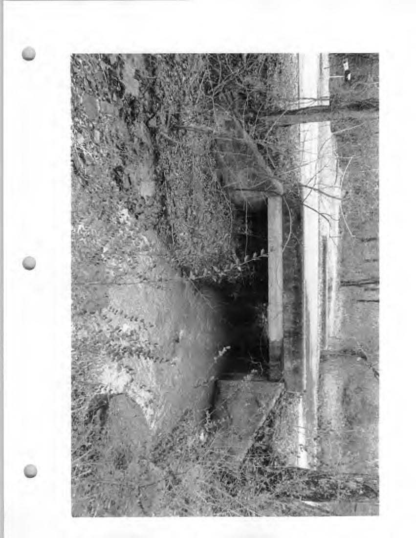
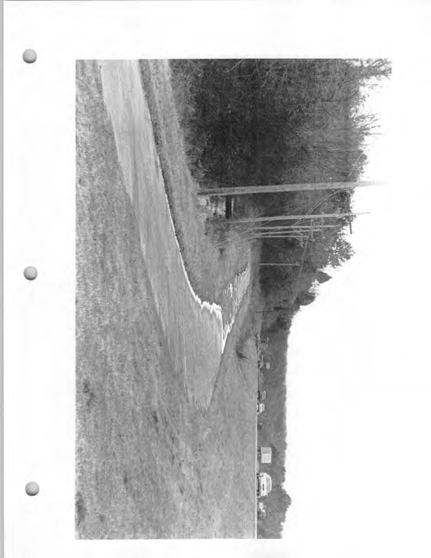
5 United States Department of the Interior National Park Service tional Register of Historic Places Continuation Sheet Name of Property: Old U.S. 71, Jenny Lind Segment County and State: Sebastian County. Arkansas Name of multiple property listing (if applicable): Arkansas Highway and Transportation Era Architecture, Section number 7 Page SUMMARY The bypassed alignment of U.S. 71 in the Jenny Lind vicinity is a two-lane concrete highway with gentle curves. Beginning at its northwest end at U.S. 71, it follows a straight alignment then curves gently to the southwest as it ascends a low part of the end of Backbone Mountain before turning back to the southeast as it descends back to the current U.S. 71. In addition, the old alignment has one stream crossing over a tributary of Bear Creek that is spanned by a simple concrete slab bridge. The highway retains its original concrete pavement throughout. The highway retains its original roadway width. ELABORATION GHWAY is bypassed section of old U.S. 71 is approximately 0.75 miles long and begins northwest of the intersection of U.S. 71 and Mt. Nebo Road southeast of Jenny Lind and proceeds in a basically southeasterly direction at the east end of Backbone Mountain before ending at the Doraul Acres Lane and current U.S. 71 intersection. The northwestern portion of the highway is flat and straight as it approaches the end of Backbone Mountain from the northwest. A couple of gentle curves allow the highway to go over the end of Backbone Mountain to its southeastern terminus. The old alignment of U.S. 71 has a width of 18 feet for two lanes of travel and no paved shoulders. (For comparison, the current American Association of State Highway and Transportation Officials Green Book indicates that a lane width of 11 feet 9 inches is desirable.) Each section of pavement is 9 feet wide and 50 feet long, and is composed of a tan stone aggregate mixed in the concrete. BRIDGE The old alignment of U.S. 71 contains one stream crossing over a tributary of Bear Creek that is spanned by a simple concrete slab bridge with concrete curbs on each side. The bridge has a length of approximately 15 feet. The bridge, which is considered to be a contributing structure, was actually built in prior to the highway's paving. INTEGRITY Overall, the bypassed alignment of U.S. 71 in the Jenny Lind vicinity has remarkable integrity. The original l pavement remains throughout the segment, and it retains its original dimensions. Although some iall portions of the highway have been patched, the patching did not alter the highway's original width. As a result, it is still easy to recognize the original construction. Additionally, the part of Sebastian County where the highway is located retains its rural setting, and the surroundings still reflect the period of significance from


6 United States Department of the Interior " 1 ational Park Service ational Register of Historic Places Continuation Sheet Name of Property: Old U.S. 71, Jenny Lind Segment County and State: Sebastian County, Arkansas Name of multiple property listing (if applicable): Arkansas Highway and Transportation Era Architecture, Section number 8 Page SUMMARY Old U.S. 71, Jenny Lind Segment, is being nominated to the National Register of Historic Places with local significance under Criterion C for its engineering. Old U.S. 71, Jenny Lind Segment, is the longest and most intact portion of the old alignment of U.S. 71 in Sebastian County. The Jenny Lind segment of U.S. 71, which is approximately 0.75 miles long, still retains its original concrete pavement. The highway section was the main automobile route in that part of Sebastian County from the time of its construction in until the current U.S. 71 was built to the east of it in As a result, it is therefore eligible for nomination under Criterion A for its association with the development of Arkansas highway culture. Old U.S. 71, Jenny Lind segment, is being submitted to the National Register of Historic Places under the ru.ultiple property listing "Arkansas Highway and Transportation Era Architecture, " in njunction with the historic context "Arkansas Highway History and Architecture, " ELABORATION The first recorded white settlement in Sebastian County occurred with the establishment of the Fort Smith military post in Captain John Rogers is the first white settler recorded on the site of Fort Smith, having arrived shortly after the end of the War of Although settlement in the Fort Smith area occurred in the early nineteenth century, settlement in the Jenny Lind and Greenwood vicinity did not begin until c The creation of Sebastian County was approved by the General Assembly on January 10, 1851, and when the County Commissioners met at Jenny Lind in May 1851, they decided to locate the county seat on forty acres of land donated by Rueben Coker. They also decided to name the new seat of justice Greenwood. 2 The growth of Greenwood was relatively slow. The first house in town was a log cabin measuring sixteen feet square that was the office of the county clerk, John Carnall. The first courthouse was a double log house built in 1852 on the comer of Center and Front streets. By the time of the Civil War's outbreak, Greenwood was a town of some importance for business in that part of the county, and it was the second largest town in Sebastian County behind Fort Smith. However, it would not be until November 13, 1884, that the town was incorporated. 3 Jenny Lind, on the other hand, was able to get a post office established in May 1851, and Thomas Yadon was the first postmaster. (Jenny Lind kept its post office off and on until 1959.) 4 The arrival of settlers in the Jenny Lind and Greenwood area also brought about a development of roads. In 1839 Fort Smith was the closest town in existence, and the roads that went out of Fort Smith at the time 1 History of Benton, Washington, Carroll, Madison, Crawford, Franklin, and Sebastian Counties, Arkansas, pp History of Benton, Washington, Carroll, Madison, Crawford, Franklin, and Sebastian Counties, Arkansas, pp History of Benton, Washington, Carroll, Madison, Crawford, Franklin, and Sebastian Counties, Arkansas, pp History of Benton, Washington, Carroll, Madison, Crawford, Franklin, and Sebastian Counties, Arkansas, pp , and Baker, Russell Pierce. From Memdag to Norsk: A Historical Directory of Arkansas Post Offices. Hot Springs, AR: Arkansas Genealogical Society, 1988, p. 117.
: Arkansas Highway and Transportation Era Architecture, 1910-1965 Section number 8 Page 2 followed the course of the Arkansas River to the")

7 United States Department of the Interior National Park Service ational Register of Historic Places Continuation Sheet Name of Property: Old U.S. 71, Jenny Lind Segment County and State: Sebastian County. Arkansas Name of multiple property listing (if applicable): Arkansas Highway and Transportation Era Architecture, Section number 8 Page 2 followed the course of the Arkansas River to the east or went to Van Buren and points beyond to the northeast. No roads penetrated into the Jenny Lind and Greenwood area. 5 By 1854, however, several roads reached into the southern part of Sebastian County, including one that proceeded south out of Fort Smith to Jenny Lind and Greenwood before continuing south over Devil's Backbone Ridge. 6 Backbone Mountain, like the other ridges in the area south of Fort Smith, would have been a formidable barrier to the first settlers arriving in the area. The 1889 History of Benton, Washington, Carroll, Madison, Crawford, Franklin, and Sebastian Counties, Arkansas, describes it by saying, "Backbone Ridge commences west of the county line, and extends into the county in an easterly direction about seven miles. It lies in the northern part of Township 6 north." 7 With an elevation change of over 300 feet from the valley to the untain's summit, it was not an easy obstacle to cross. By the early twentieth-century when the route of U.S. 71 was laid out, because of the presence of improved machinery, it would have been easier to construct a highway over Backbone Mountain (as was done over Devil's Backbone), but the route was directed around the east end of the mountain. This route was also logical since it was near the location of a gap in Long Ridge, which was located just to the north. (It was actually Highway A-4 at the time-the route would not be designated U.S. 71 until after the creation of the U.S. highway system in ) As with many of Arkansas's highways, there was a tremendous effort in the 1920s to improve and upgrade U.S. 71 to the best standards of the period. The first work done on the highway in the Jenny Lind area to accomplish this was to complete grading and drainage structures, and to build the necessary concrete bridges. The contract for the grading of the road and construction of the drainage structures went to W. P. McCoy & Son of Fort Smith. Their proposal for the project was received August 30, For the mile section (Section 14 of U.S. 71, State Job #404), which includes the segment in the Jenny Lind area being nominated, they submitted a bid of $78, , and estimated that it would take 300 calendar days to finish the project. The final payment to the contractor, however, was $87,832.77, which overran the initial estimates. 9 At the same time that the grading and drainage structures were being taken care of, another contract was underway to construct the route's concrete bridges. The contract for the concrete bridges went to the O'Hagan & Mc Vicker Company of Kansas City, Missouri. Their proposal for the project was received urr, David. H. Map of Mississippi, Louisiana & Arkansas exhibiting the post offices, post roads, canals, rail roads, &c. Map. London: J. Arrowsmith, Colton 's railroad & township map of Arkansas. Map. New York, D. F. Shall, History of Benton, Washington, Carroll, Madison, Crawford, Franklin, and Sebastian Counties, Arkansas, p Ibid. 9 Arkansas State Highway Commission. Ninth Biennial Report of the Arkansas State Highway Commission. Russellville, AR: Russellville Printing Company, 1930, pp
: Arkansas Highway and Transportation Era Architecture, 1910-1965 Section number 8 Page 3 August 30, 1927.")

8 United States Department of the Interior National Park Service ational Register of Historic Places Continuation Sheet Name of Property: Old U.S. 71, Jenny Lind Segment County and State: Sebastian County. Arkansas Name of multiple property listing (if applicable): Arkansas Highway and Transportation Era Architecture, Section number 8 Page 3 August 30, For 227 feet of concrete bridges (State Job #405), which includes the bridge on this segment, they submitted a bid of $31,696.05, and estimated that it would take 180 calendar days to finish the project. The final payment to the contractor, however, was $30,548.75, which was actually less than the original estimates. 10 Once the grading, drainage structures, and concrete bridges were finished, paving the highway could get underway. The paving work done on the Jenny Lind segment of highway, was not only a state project, but a federal project as well (FAP #164-A). 11 The contract for paving U.S. 71 in the Jenny Lind area went to the Walter J. Bryson Paving Company of Jacksonville, Florida. Their proposal for the project was received December 14, For the mile section (State Job #468), which includes the Jenny Lind segment, ey submitted a bid of $250,632.48, and estimated that it would take 250 calendar days to finish the project. dditionally, the state was going to furnish an estimated $63, worth of material for a total commitment of $314, The final payment to the contractor, however, was $268, while the state furnished $65, worth of material. As a result, the final cost of the section was $333,886.50, which overran the initial estimates. 12 Once U.S. 71 was completed in the Jenny Lind area, it made travel in the area a lot easier. The fact that this portion of U.S. 71 was the main route between Fort Smith and Texarkana meant that it was also a highly traveled road for both automobile and truck traffic. The amount of traffic using U.S. 71 ultimately led to the construction of the current U.S. 71 to the northeast. The new highway, which was opened to traffic in 1973, bypassed Jenny Lind and Greenwood, creating a much straighter corridor. 13 Today almost the entire length of the old alignment of U.S. 71 in the Jenny Lind area is still in use as Doraul Acres Lane and a part of Mt. Nebo Road, and it is still possible to drive most of the Jenny Lind segment of the alignment being nominated. (A debris pile in the middle prevents driving through on the entire segment, although both parts are passable.) Remarkably, all of the alignment retains the original concrete pavement, although some portions have been patched. However, the pavement retains its original dimensions. As a result, it is still easy to recognize the original construction. U.S. 71 is currently the main highway between Fort Smith and Texarkana, and has been for many years. Due to the amount of traffic that uses the highway, much of the road has been upgraded to current highway :Arkansas State Highway Commission. Ninth Biennial Report of the Arkansas State Highway Commission. Russellville, AR: Russellville Printing Company, 1930, pp Arkansas State Highway Commission. Ninth Biennial Report of the Arkansas State Highway Department. Russellville, AR: Russellville Printing Company, 1930, p Arkansas State Highway Commission. Ninth Biennial Report of the Arkansas State Highway Commission. Russellville, AR: Russellville Printing Company, 1930, pp Robert W. Scoggin, to the author, 11 March 2009.


9 United States Department of the Interior l'\lational Park Service ational Register of Historic Places Continuation Sheet Name of Property: Old U.S. 71, Jenny Lind Segment County and State: Sebastian County, Arkansas Name of multiple property listing (if applicable): Arkansas Highway and Transportation Era Architecture, Section number 8 Page 4 standards. Early sections of the highway are rare, especially ones that are still drivable. As a result, the old alignment of U.S. 71 in the Jenny Lind vicinity remains an extremely intact example of early highway design and construction, and a tangible reminder of early highway travel in Sebastian County. STATEMENT OF SIGNIFICANCE Old U.S. 71, Jenny Lind Segment, is being nominated to the National Register of Historic Places with local significance under Criterion C for its engineering. Old U.S. 71, Jenny Lind Segment, is the longest and most intact portion of the old alignment of U.S. 71 in Sebastian County. The Jenny Lind segment of U.S. 71, which is approximately 0.75 miles long, still retains its original concrete pavement. The highway section was the main automobile route in that part of Sebastian County from the time of its construction in until the current U.S. 71 was built to the east of it in As a result, it is therefore eligible for nomination under Criterion A for its association with the development of Arkansas highway culture. Old U.S. 71, Jenny Lind segment, is being submitted to the National Register of Historic Places under the multiple property listing "Arkansas Highway and Transportation Era Architecture, " in conjunction with the historic context "Arkansas Highway History and Architecture, "


10 United States Department of the Interior l\lational Park Service ational Register of Historic Places Continuation Sheet Name of Property: Old U.S. 71, Jenny Lind Segment County and State: Sebastian County, Arkansas Name of multiple property listing (if applicable): Arkansas Highway and Transportation Era Architecture, Section number 9 Page BIBLIOGRAPHY Arkansas State Highway Commission. Ninth Biennial Report of the Arkansas State Highway Commission. Russellville, AR: Russellville Printing Company, Baker, Russell Pierce. From Memdag to Norsk: A Historical Directory of Arkansas Post Offices. Hot Springs, AR: Arkansas Genealogical Society, Burr, David. H. Map of Mississippi, Louisiana & Arkansas exhibiting the post offices, post roads, canals, rail roads, &c. Map. London: J. Arrowsmith, 1839.!ton's railroad & township map of Arkansas. Map. New York, D. F. Shall, History of Benton, Washington, Carroll, Madison, Crawford, Franklin, and Sebastian Counties, Arkansas. Chicago: The Goodspeed Publishing Co., Scoggin, Robert W. to the author. 11March2009. State of Arkansas. Second Biennial Report of the Department of State Lands, Highways and Improvements. Little Rock: Democrat P. & L. Co., c State of Arkansas. Sixth Biennial Report of the Department of State Lands, Highways and Improvements. Conway, AR: Conway Printing Co., c.1925.


11 United States Department of the Interior National Park Service ational Register of Historic Places Continuation Sheet Name of Property: Old U.S. 71, Jenny Lind Segment County and State: Sebastian County, Arkansas Name of multiple property listing (if applicable}: Arkansas Highway and Transportation Era Architecture, Section number 10 Page VERBAL BOUNDARY DESCRIPTION Beginning at the Hidden Valley Way, Old Jenny Lind Loop, U.S. 71, and Mt. Nebo Road intersection, the alignment of U.S. 71 follows Mt. Nebo Road and Doraul Acres Lane until it intersects current U.S. 71. The width of the boundary includes 10 feet on either side of the highway centerline. BOUNDARY JUSTIFICATION This boundary contains the most intact portion of the U.S. 71 highway alignment in the Jenny Lind vicinity.
12

13


14 I( ' t \' ~. '' \ f '{..' ' ' < '>-. -.., '.... (. ' ft '/' r i \ ' J j' : j : t A I I / ~. j f '....!. I }


15 ...

16
.).. - - -- J'!,.J..:;:1 -j' _.")

17 --,,.,..:....::;::; - I,, -) -, v \ ' ;I 0l vl I <..> J\ CJ) l -! ---..:;, '-' j \ '-" l:_ OJ ' ' _;;,! -~ _;j -... \.-: l ~._.::,;..._/ - - :;.. J"\.j _,i'. ).) J'!,.J..:;:1 -j' _.J I c --\ 3 \}I - I ' - r ~ [, -;- ~/ G,!/", -. '-..1 (' (_, \(',,, """' \..-( - z:, -; (.... I -(. J 1 ~~~~~+++':~~~~~~~--m~~itr~~~~flfr; 0 / :D w I N ( ~ :D
National Register of Historic Places Registration Form
 NPS Form 10-900 OMB No. 10024-0018 (Oct. 1990) Registration Form This form is for use in nominating or requesting determinations for individual properties and districts. See instructions in How to Complete
D not for publication D vicinity
 NPS Fonn I 0-900 (Oct. 1990) OMB No. 10024-0018 United States Department of the Interior National Park Service National Register of Historic Places Registration Form This fom1 is for use in nominating
street & number: COUNTY ROUTE 3, HC-88, BOX 17 not for publication: N/A city/town: WHEELER vicinity: X state: WV county: WEBSTER code: 101 zip code:
 NPS Forn 10-900 OMB No. 10024-0018 (Oct. 1990) United States Department of the Interior National Park Service NATIONAL REGISTIR OF HISTORIC PLACES REGISTRATICN FCRX =========================================================---------=======
; * --.-.,., rj ; United States Department of the Interior \ ' '"] I National Park Service
![; * --.-.,., rj ; United States Department of the Interior \ ' '] I National Park Service](/thumbs/88/117765392.jpg "; * --.-.,., rj ; United States Department of the Interior \ ' '] I National Park Service") NPS Form 10-900 OMB No. 1024-0018 (Rev. 10-90) : / i' -_ :. - : ; ; * --.-.,., rj ; United States Department of the Interior \ ' '"] I National Park Service NATIONAL REGISTER OF HISTORIC PLACES REGISTRATION
NPS Form 10-900 OMB No. 1024-0018 (Rev. 10-90) : / i' -_ :. - : ; ; * --.-.,., rj ; United States Department of the Interior \ ' '"] I National Park Service NATIONAL REGISTER OF HISTORIC PLACES REGISTRATION
United States Department of the Interior National Park Service. Boundary Expansion Listed in National Register January 11, 2017
 NPS Form 10900-a (Rev. 8/2002) OMB No. 10240018 United States Department of the Interior National Park Service Boundary Expansion Listed in National Register January 11, 2017 National Register of Historic
D not for publication
 NPS Form 10-900 toct. 19901 OMB No. ltl(j2 _.-tl018 United States Department of the Interior National Park Service National Register of Historic Places egistration Form This form is for use in nominating
National Register of Historic Places Registration Form
 NPS Form 10-900 OMB No. 1024-0018 (Expires 5/31/2012) United States Department of the Interior National Register Listed National Park Service May 1, 2012 National Register of Historic Places Registration
National Register of Historic Places Registration Form
 National Park Service National Register of Historic Places Registration Form This form is for use in nominating or requesting determinations for individual properties and districts. See instructions in
National Register of Historic Places Registration Form
 NPS Form 10-900 OMB No. 10024-0018 (Oct. 1990) United States Department of the Interior National Register of Historic Places Registration Form This form is for use in nominating or requesting determinations
National Register of Historic Places Registration Form
 National Park Service National Register of Historic Places Registration Form This form is for use in nominating or requesting determinations for individual properties and districts. See instructions in
National Register of Historic Places Registration Form
 NPS Form 10-900 OMB No. 1024-0018 (Expires 5/31/2012) United States Department of the Interior National Register Listed National Park Service May 1, 2012 National Register of Historic Places Registration
National Register of Historic Places Registration Form
 NPS Form 10-900 OMB No. 10024-0018 (Oct. 1990) National Register of Historic Places Registration Form This form is for use in nominating or requesting determinations for individual properties and districts.
National Register of Historic Places Registration Form
 NPS Form 10-900 OMB No. 10024-0018 (Oct. 1990) United States Department of the Interior National Park Service National Register of Historic Places Registration Form 1. Name of Property historic name Hickory
AH pp. I Ti. Nov 7 I) I I y
 I I y") ..------------------------------------------ ------------ - - -- - NPS Form 10-900 (Rev. 8-86) United States Department of the Interior ~a tional Park Service NATIONAL REGISTER OF HISTORIC PLACES REGISTRATION
..------------------------------------------ ------------ - - -- - NPS Form 10-900 (Rev. 8-86) United States Department of the Interior ~a tional Park Service NATIONAL REGISTER OF HISTORIC PLACES REGISTRATION
National Register of Historic Places Multiple Property Documentation Form
 NPS Form 10-900-b OMB No. 1024-0018 Revised Aug. 2002 Expires 12-31-2005 Multiple Property Documentation Form This form is for use in documenting multiple property groups relating to one or several contexts.
NPS Form OMB No (Oct. 1990)
") NPS Form 10-900 OMB No. 10024-0018 (Oct. 1990) United States Department of the Interior National Park Service NATIONAL REGISTER OF HISTORIC PLACES REGISTRATION FORM 1. Name of Property historic name:_lost
NPS Form 10-900 OMB No. 10024-0018 (Oct. 1990) United States Department of the Interior National Park Service NATIONAL REGISTER OF HISTORIC PLACES REGISTRATION FORM 1. Name of Property historic name:_lost
Total 1 Total. Current Functions (Enter categories from instructions) Materials (Enter categories from instructions)
 Materials (Enter categories from instructions)") Site Inventory Form State Inventory No. 29-00962 New Supplemental State Historical Society of Iowa Part of a district with known boundaries (enter inventory no.) 29-03685 (November 2005) Relationship:
Site Inventory Form State Inventory No. 29-00962 New Supplemental State Historical Society of Iowa Part of a district with known boundaries (enter inventory no.) 29-03685 (November 2005) Relationship:
National Register of Historic Places Registration Form
 NPS Form 10-900 OMB No. 10024-0018 (Oct. 1990) United States Department of the Interior National Park Service National Register of Historic Places Registration Form 1. Name of Property historic name other
National Register of Historic Places Registration Form
 NPS Form 10-900 OMB No. 10024-0018 (Oct. 1990) National Register of Historic Places Registration Form This form is for use in nominating or requesting determinations for individual properties and districts.
National Register of Historic Places Registration Form
 NPS Form 10-900 OMB No. 10024-0018 (Oct. 1990) Registration Form This form is for use in nominating or requesting determinations for individual properties and districts. See instructions in How to Complete
 ~. ',. ( NPS Form 10-900 (Rev. 8-86) NR I ;s+eca Cf/ S /q~ OMB No. 1024-0018 United States Department of the Interior National Park Service NATIONAL REGISTER OF HISTORIC PLACES REGISTRATION FORM ------------------------------------------------------------------------
National Register of Historic Places Registration Form
 NPS Form 10-900 OMB No. 10024-0018 (Oct. 1990) Registration Form This form is for use in nominating or requesting determinations for individual properties and districts. See instructions in How to Complete
I Signature of commenting official Date I. / Title State or Federal agencylbureau or Tribal Government 1
 National Park Service National Register of Historic Places Registration Form LISTED ON: VLR 09/20/2012 NRHP 11/20/2012 This form is for use in nominating or requesting determinations for individual properties
National Register of Historic Places Registration Form
 NPS Form 10-900 (Oct. 1990) OMB NO. 10024-0018 Registration Form This form is for use in nominating or requesting determinations for individual properties and districts. See instructions in How to Complete
Maryland Historical Trust Inventory No. 15/6 Maryland Inventory of Historic Properties Form
 Inventory No. 15/6 Maryland Inventory of 1. Name of Property (indicate preferred name) historic Becraft Farm other 2. Location street and number 28500 Ridge Road not for publication city, town Mount Airy
National Register of Historic Places Continuation Sheet
 NFS Form 10-900-a OMB Approval No. 1024-0018 (8-86) United States Department of the Interior National Register of Historic Places Continuation Sheet Section number Page SUPPLEMENTARY LISTING RECORD NRIS
United States Department of the Interior National Park Service NATIONAL REGISTER OF HISTORIC PLACES REGISTRATION FORM
 NPS Form 10-900 (Oct. 1990) OMB NO. 10024-0018 United States Department of the Interior National Park Service NATIONAL REGISTER OF HISTORIC PLACES REGISTRATION FORM As the designated authority under the
United States Department of the Interior National Park Service NATIONAL REGISTER OF HISTORIC PLACES REGISTRATION FORM
 NPS Form 10-900 (Oct. 1990) OMB No. 10024-0018 United States Department of the Interior National Park Service NATIONAL REGISTER OF HISTORIC PLACES REGISTRATION FORM 1. DR JOHN C. IRONS RESIDENCE hlstoric
NPS Form a OMB Approval No SUPPLEMENTARY LISTING RECORD. NRIS Reference Number: Date Listed: 12/29/2000
 NPS Form 10-900-a OMB Approval No. 1024-0018 United States Department of the Interior National Register of Historic Places Continuation Sheet Section number Page SUPPLEMENTARY LISTING RECORD NRIS Reference
VARIOUS RESTRICTED CATEGORY HELICOPTERS
 Page 1 2012-14-11 VARIOUS RESTRICTED CATEGORY HELICOPTERS Amendment 39-17125 Docket No. FAA-2012-0739; Directorate Identifier 2012-SW-044-AD. PREAMBLE (a) Applicability This AD applies to Arrow Falcon
Current Functions (Enter categories from instructions) Materials (Enter categories from instructions)
 Materials (Enter categories from instructions)") Site Inventory Form State Inventory No. 92-00542 New Supplemental State Historical Society of Iowa Part of a district with known boundaries (enter inventory no.) 92-00349 (November 2005) Relationship:
Site Inventory Form State Inventory No. 92-00542 New Supplemental State Historical Society of Iowa Part of a district with known boundaries (enter inventory no.) 92-00349 (November 2005) Relationship:
THE BARNACLE 3485 MAIN HIGHWAY
 THE BARNACLE 3485 MAIN HIGHWAY Designation Report City of Miami REPORT OF THE CITY OF MIAMI PLANNING AND ZONING DEPARTMENT TO THE HISTORIC AND ENVIRONMENTAL PRESERVATION BOARD ON THE POTENTIAL DESIGNATION
SUPERSEDED. [Docket No. FAA ; Directorate Identifier 2015-SW-014-AD; Amendment ; AD ]
![SUPERSEDED. [Docket No. FAA ; Directorate Identifier 2015-SW-014-AD; Amendment ; AD ]](/thumbs/95/123244441.jpg "SUPERSEDED. [Docket No. FAA ; Directorate Identifier 2015-SW-014-AD; Amendment ; AD ]") [Federal Register Volume 80, Number 95 (Monday, May 18, 2015)] [Rules and Regulations] [Pages 28172-28175] From the Federal Register Online via the Government Publishing Office [www.gpo.gov] [FR Doc No:
[Federal Register Volume 80, Number 95 (Monday, May 18, 2015)] [Rules and Regulations] [Pages 28172-28175] From the Federal Register Online via the Government Publishing Office [www.gpo.gov] [FR Doc No:
National Register of Historic Places Registration Form
 NPS Form 10-900 OMB No. 1024-0018 (Rev. 10-90) United States Department of the Interior National Park Service National Register of Historic Places Registration Form 1. Name of Property historic name Newcomer
 Page 1 Original Update HISTORICAL STRUCTURE FORM FLORIDA MASTER SITE FILE Consult Guide To Historical Structure Forms for detailed instructions Site # 8OR9844 Recorder # 26 Recorder Date 2/20/08 Site Name
Appendix D Reevaluation of Structures on Bock House Property
 Appendix D Reevaluation of Structures on Bock House Property Page 1 Original Update HISTORICAL STRUCTURE FORM FLORIDA MASTER SITE FILE Consult Guide To Historical Structure Forms for detailed instructions
1 buildings sites structures objects 1 0 TOTAL
 Name of Property County and State 4. National Park Service Certification --------- I, hereby certify that this property is: Signature of Keeper Date of Action entered in the National Register See continuation
National Register of Historic Places Registration Form
 NPS Form 10-900 OMB No. 10024-0018 (Oct. 1990) Registration Form This form is for use in nominating or requesting determinations for individual properties and districts. See instructions in How to Complete
HISTORIC AMERICAN ENGINEERING RECORD COVE CREEK SPILLWAY BRIDGE. HAER No. AR-83
 HISTORIC AMERICAN ENGINEERING RECORD COVE CREEK SPILLWAY BRIDGE LOCATION: Spanning Cove Creek Spillway at State Highway 309 (formerly Paris-Mt. Magazine Road), Corley vicinity, Logan County, Arkansas UTM:
National Register of Historic Places Registration Form
 NPS Form 10-900 OMB No. 1024-0018 (Rev. 10-90) United States Department of the Interior National Park Service National Register of Historic Places Registration Form 1. Name of Property historic name Evans,
AHPP. LISTED ========================================================================
 NPS Form 10-900 (Rev. 8-86) Jnited States Department of the Interior ational Park Service OMB No. 1024-0018 LISTED NATIONAL REGISTER OF HISTORIC PLACES REGISTRATION FORM AHPP. 1. Historic Name: Bush-Dubisson
State Level Historic Documentation Report. John Blue Bridge Hampshire County
 State Level Historic Documentation Report State Project No. S314-28-22.27 Federal Project No. BR-0028(058)D John Blue Bridge Hampshire County Prepared by: Randy Epperly, Historian Department of Transportation
SUPERSEDED [ U] DEPARTMENT OF TRANSPORTATION. Federal Aviation Administration. 14 CFR Part 39 [66 FR /5/2001]
![SUPERSEDED [ U] DEPARTMENT OF TRANSPORTATION. Federal Aviation Administration. 14 CFR Part 39 [66 FR /5/2001]](/thumbs/89/99040723.jpg "SUPERSEDED [ U] DEPARTMENT OF TRANSPORTATION. Federal Aviation Administration. 14 CFR Part 39 [66 FR /5/2001]") [4910-13-U] DEPARTMENT OF TRANSPORTATION Federal Aviation Administration 14 CFR Part 39 [66 FR 13227 3/5/2001] [Docket No. 2000-NM-416-AD; Amendment 39-12128; AD 2001-04-09] RIN 2120-AA64 Airworthiness
[4910-13-U] DEPARTMENT OF TRANSPORTATION Federal Aviation Administration 14 CFR Part 39 [66 FR 13227 3/5/2001] [Docket No. 2000-NM-416-AD; Amendment 39-12128; AD 2001-04-09] RIN 2120-AA64 Airworthiness
STATEMENT OF SIGNIFICANCE
 STATEMENT OF SIGNIFICANCE The National Register of Historic Places identifies three concepts (are historic significance, historic context, and historic integrity) that are used to evaluate whether or not
ate: AR County: Pulaski Code: AR Zip Code: Noncontributing buildings sites structures objects Total
 Mims-Ereedlove-Priest-Weatherton House Name of Property Little Rock, AR County and State ~- -,s Form 10-900 'V. 8-86) OMB No. 1024-0018 United States Department of the Interior National Park Service NATIONAL
[Docket No. FAA ; Product Identifier 2016-NE-32-AD] Airworthiness Directives; Honeywell International Inc.
![[Docket No. FAA ; Product Identifier 2016-NE-32-AD] Airworthiness Directives; Honeywell International Inc.](/thumbs/89/99246846.jpg "[Docket No. FAA ; Product Identifier 2016-NE-32-AD] Airworthiness Directives; Honeywell International Inc.") This document is scheduled to be published in the Federal Register on 01/30/2018 and available online at https://federalregister.gov/d/2018-01704, and on FDsys.gov [4910-13-P] DEPARTMENT OF TRANSPORTATION
This document is scheduled to be published in the Federal Register on 01/30/2018 and available online at https://federalregister.gov/d/2018-01704, and on FDsys.gov [4910-13-P] DEPARTMENT OF TRANSPORTATION
Other Principle Arterials Minor Arterial Major Collector Minor Collector Local
 CHAPTER 10 TRANSPORTATION Introduction The system of public roads in East Pikeland Township is decidedly rural in character. Since the 1984, the road network has remained much the same, with the addition
Architectural Inventory Form
 OAHP1403 Rev. 9/98 COLORADO CULTURAL RESOURCE SURVEY Architectural Inventory Form Official eligibility determination (OAHP use only) Date Initials Determined Eligible- NR Determined Not Eligible- NR Determined
NATIONAL REGISTER OF HISTORIC PLACES REGISTRATION FORM
 NPS Form 10-900 OMB No. 1024-0018 (Rev. 10-90) United States Department of the Interior National Park Service NATIONAL REGISTER OF HISTORIC PLACES REGISTRATION FORM 1. Name of Property historic name Compton-Johnson
National Register of Historic Places Registration Form
 National Park Service National Register of Historic Places Registration Form This form is for use in nominating or requesting determinations for individual properties and districts. See instructions in
[Docket No. FAA ; Directorate Identifier 2013-NM-081-AD] Airworthiness Directives; The Boeing Company Airplanes
![[Docket No. FAA ; Directorate Identifier 2013-NM-081-AD] Airworthiness Directives; The Boeing Company Airplanes](/thumbs/95/123065974.jpg "[Docket No. FAA ; Directorate Identifier 2013-NM-081-AD] Airworthiness Directives; The Boeing Company Airplanes") This document is scheduled to be published in the Federal Register on 08/05/2013 and available online at http://federalregister.gov/a/2013-18800, and on FDsys.gov [4910-13-P] DEPARTMENT OF TRANSPORTATION
This document is scheduled to be published in the Federal Register on 08/05/2013 and available online at http://federalregister.gov/a/2013-18800, and on FDsys.gov [4910-13-P] DEPARTMENT OF TRANSPORTATION
Hwy Retaining Wall/ Sea Wall. Not Eligible, see Statement of Significance Also member of listed NR district: Mantorville Historic District
 Historic Name CS # 2007 Other Name SHPO Inv # Location E and W sides of TH 57 between 6th St and 7th St Hwy District Reference City/Township County Mantorville, City of Dodge Acres Twp Rng Sec 107N 16W
NPS Form OMB No (Rev. Aug. 2002) (Expires )
 (Expires )") Beaconsfield Supply Store,1 NATIONAL REGISTER FORMS TEMPLATE January 2006 NPS Form 10-900 OMB No. 1024-0018 (Rev. Aug. 2002) (Expires 1-31-2009) REGISTRATION FORM 1. Name of Property historic name Beaconsfield
Beaconsfield Supply Store,1 NATIONAL REGISTER FORMS TEMPLATE January 2006 NPS Form 10-900 OMB No. 1024-0018 (Rev. Aug. 2002) (Expires 1-31-2009) REGISTRATION FORM 1. Name of Property historic name Beaconsfield
Appendix E Historic Property Inventory Forms
 Appendix E Historic Property Inventory Forms TECHNICAL MEMORANDUM Sound Transit Federal Way Link Extension WISAARD Survey Entries PREPARED FOR: COPY TO: PREPARED BY: Sound Transit Alisa Swank/ CH2M MaryNell
[Docket No. FAA ; Directorate Identifier 2007-NM-291-AD; Amendment ; AD R1]
![[Docket No. FAA ; Directorate Identifier 2007-NM-291-AD; Amendment ; AD R1]](/thumbs/80/81019372.jpg "[Docket No. FAA ; Directorate Identifier 2007-NM-291-AD; Amendment ; AD R1]") Federal Register: January 7, 2008 (Volume 73, Number 4)] [Rules and Regulations] [Page 1052-1055] From the Federal Register Online via GPO Access [wais.access.gpo.gov] [DOCID:fr07ja08-5] DEPARTMENT OF
Federal Register: January 7, 2008 (Volume 73, Number 4)] [Rules and Regulations] [Page 1052-1055] From the Federal Register Online via GPO Access [wais.access.gpo.gov] [DOCID:fr07ja08-5] DEPARTMENT OF
Name of related multiple property listing: Historic and Architectural Resources in Abilene, Texas
 NPS Form 10-900 (Rev. 8-86) United States Department of the Interior National Park Service NATIONAL REGISTER OF HISTORIC PLACES REGISTRATION FORM 1. NAME OF PROPERTY Historic name: Magee, J.D., House Other
APPENDIX OFFICIAL MAP ORDINANCE OF HAMILTONBAN TOWNSHIP OFFICIAL MAP NARRATIVE
 APPENDIX A OFFICIAL MAP ORDINANCE OF HAMILTONBAN TOWNSHIP OFFICIAL MAP NARRATIVE INTRODUCTION: The Official Map of Hamiltonban Township has been prepared to identify those lands and features that Hamiltonban
M7 AEROSPACE LP
 Page 1 2011-02-04 M7 AEROSPACE LP (TYPE CERTIFICATE PREVIOUSLY HELD BY FAIRCHILD AIRCRAFT INCORPORATED) Amendment 39-16577 Docket No. FAA-2011-0014 Directorate Identifier 2010-CE-066-AD PREAMBLE Effective
, Name of Property. ... Ownership of Property: public-state
 1 6 NPS Form 10-900 (Rev. 8-86) OMB NO. 1024-0018 IVR 4/zd/T-- United States Department of the Interior National Park Service NATIONAL REGISTER OF HISTORIC PLACES REGISTRATION FORM --------------d---d----------------4------------------------
National Register of Historic Places Registration Form
 NPS Form 10-900 OMB No. 1024-0018 (Rev. 10-90) United States Department of the Interior National Park Service National Register of Historic Places Registration Form 1. Name of Property historic name Strode-Morrison-Tabler
_------_ As the designated acthority under the National Historic Preservation Act of 1986, as amended, 1 hereby certify that this
 ===================================== ===== 4. State/Federal Agency Certification _- - ----_--_-_------_----------- --_- - -_--------------------- ---------------- _------_--------- As the designated acthority
National Register of Historic Places Registration Form
 NPS Form 10-900 OMB No. 10024-0018 (Oct. 1990) Registration Form This form is for use in nominating or requesting determinations for individual properties and districts. See instructions in How to Complete
not for publication: N/A city/town: St. Albans vicinity: N/A state: WV county : Kanawha code: 039 zip code:25177
 #PS F o 10-900 ~ OMB NO. 10024-0018 (OC~. 1990) United States Department of the Interior National Park Service LSATIOHAL REGISTER OF HISTORIC PLACES REGISTRATION FORM 1. Name of Property ST. ALBANS CHESAPEAKE
Vista Field Airport. Master Plan Update. February, Prepared for: Port of Kennewick One Clover Island Kennewick, Washington
 Vista Field Airport February, 2006 Prepared for: Port of Kennewick One Clover Island Kennewick, Washington 99336 Prepared by: J-U-B ENGINEERS, Inc. 2810 W. Clearwater Avenue, Suite 201 Kennewick, Washington
county Lonoke code 085 zip code
 ~~~~~~~~~~~ AR NPS Form I 0-900 (Oct. 1990) United States Department of the Interior National Park Service National Register of Historic Places egistration Form w-l.3-1 / OMB No. 10024-0018 This form is
United States Department of the Interior National Park Service NATIONAL REGISTER OF HISTORIC PLACES REGISTRATION FORM. Wilmoth, Bernard E.
 NPS Form 10-900 OMB No. 10024-0018 (Oct. 1990) United States Department of the Interior National Park Service NATIONAL REGISTER OF HISTORIC PLACES REGISTRATION FORM 1. Name of Property historic name: other
- request for determination of eligibility meets the documentation
 NPS Form 10-900 OMB No. 10024-0018 (Oct. 1990) United States Department of the Interior National Park Service NATIONAL REGISTER OF HISTORIC PLACES REGISTRATION FORM historic name: Reed's Mill other name/site
United States Department of the Interior National Park Service NATIONAL REGISTER OF HISTORIC PLACES REGISTRATION FORM
 NPS Form 10-900 (Rev. 8-86) OMB No. 1024-0018 United States Department of the Interior National Park Service NATIONAL REGISTER OF HISTORIC PLACES REGISTRATION FORM other name/site number: "Maple Shadows:"
NE¼ of NE¼ of NE¼ of NE¼ of section Roof configuration (enter one): Gabled Roof / Front Gabled Roof
: Gabled Roof / Front Gabled Roof") OAHP1403 Rev. 9/98 COLORADO CULTURAL RESOURCE SURVEY Official Eligibility Determination (OAHP use only) Date Initials Determined Eligible - National Register Architectural Inventory Form Determined Not
OAHP1403 Rev. 9/98 COLORADO CULTURAL RESOURCE SURVEY Official Eligibility Determination (OAHP use only) Date Initials Determined Eligible - National Register Architectural Inventory Form Determined Not
D not for publication D vicinity
 ~~~~~~~~~~~ county NPS Form 10-900 (Oct. 1990) OMB No. JUUL'l Uvio National Park Service ""lational Register of Historic Places egistration Form This form is for use in nominating or requesting determinations
SUPERSEDED. [Docket No. FAA ; Directorate Identifier 2011-SW-005-AD; Amendment ; AD ]
![SUPERSEDED. [Docket No. FAA ; Directorate Identifier 2011-SW-005-AD; Amendment ; AD ]](/thumbs/95/123244499.jpg "SUPERSEDED. [Docket No. FAA ; Directorate Identifier 2011-SW-005-AD; Amendment ; AD ]") [Federal Register Volume 76, Number 66 (Wednesday, April 6, 2011)] [Rules and Regulations] [Pages 18865-18869] From the Federal Register Online via the Government Printing Office [www.gpo.gov] [FR Doc
[Federal Register Volume 76, Number 66 (Wednesday, April 6, 2011)] [Rules and Regulations] [Pages 18865-18869] From the Federal Register Online via the Government Printing Office [www.gpo.gov] [FR Doc
Register of Historic Kansas Places Registration Form
 Kansas State Historical Society Register of Historic Kansas Places Registration Form This form is for use in nominating individual properties and districts. The format is similar to the National Register
WEKIVA WILD AND SCENIC RIVER ACT OF 2000
 PUBLIC LAW 106 299 OCT. 13, 2000 WEKIVA WILD AND SCENIC RIVER ACT OF 2000 VerDate 11-MAY-2000 01:59 Oct 20, 2000 Jkt 069139 PO 00000 Frm 00001 Fmt 6579 Sfmt 6579 E:\PUBLAW\PUBL299.106 APPS27 PsN: PUBL299
National Register of Historic Places Registration Form
 United States Department of the Interior National Register Listed National Park Service August 6, 2013 National Register of Historic Places Registration Form This form is for use in nominating or requesting
National Register of Historic Places Registration Form
 NPS Form 10-900 OMB No. 1024-0018 (Expires 5/31/2012) United States Department of the Interior National Park Service National Register of Historic Places Registration Form Listed in state register 05/07/1994
[Docket No. FAA ; Directorate Identifier 2007-CE-025-AD; Amendment ; AD ]
![[Docket No. FAA ; Directorate Identifier 2007-CE-025-AD; Amendment ; AD ]](/thumbs/96/128270761.jpg "[Docket No. FAA ; Directorate Identifier 2007-CE-025-AD; Amendment ; AD ]") [Federal Register: April 3, 2007 (Volume 72, Number 63)] [Rules and Regulations] [Page 15822-15824] From the Federal Register Online via GPO Access [wais.access.gpo.gov] [DOCID:fr03ap07-8] DEPARTMENT OF
[Federal Register: April 3, 2007 (Volume 72, Number 63)] [Rules and Regulations] [Page 15822-15824] From the Federal Register Online via GPO Access [wais.access.gpo.gov] [DOCID:fr03ap07-8] DEPARTMENT OF
in 7.x M (Oct. 1990) United States Department of the Interior National Park Service 1. NAME OF PROPERTY
 United States Department of the Interior National Park Service 1. NAME OF PROPERTY") (Oct. 1990) United States Department of the Interior National Park Service NATIONAL REGISTER OF HISTORIC PLACES REGISTRATION FORM 1. NAME OF PROPERTY HISTORIC NAME: Jacala Restaurant OTHER NAME/SITE NUMBER:
(Oct. 1990) United States Department of the Interior National Park Service NATIONAL REGISTER OF HISTORIC PLACES REGISTRATION FORM 1. NAME OF PROPERTY HISTORIC NAME: Jacala Restaurant OTHER NAME/SITE NUMBER:
COVER SHEET. Reduced Vertical Separation Minimum (RVSM) Information Sheet Part 91 RVSM Letter of Authorization
 Information Sheet Part 91 RVSM Letter of Authorization") COVER SHEET Reduced Vertical Separation Minimum (RVSM) Information Sheet Part 91 RVSM Letter of Authorization NOTE: FAA Advisory Circular 91-85 ( ), Authorization of Aircraft and Operators for Flight in
COVER SHEET Reduced Vertical Separation Minimum (RVSM) Information Sheet Part 91 RVSM Letter of Authorization NOTE: FAA Advisory Circular 91-85 ( ), Authorization of Aircraft and Operators for Flight in
[Docket No. FAA ; Product Identifier 2017-SW-132-AD; Amendment ; AD ]
![[Docket No. FAA ; Product Identifier 2017-SW-132-AD; Amendment ; AD ]](/thumbs/90/102216695.jpg "[Docket No. FAA ; Product Identifier 2017-SW-132-AD; Amendment ; AD ]") [Federal Register Volume 83, Number 162 (Tuesday, August 21, 2018)] [Rules and Regulations] [Pages 42205-42207] From the Federal Register Online via the Government Publishing Office [www.gpo.gov] [FR Doc
[Federal Register Volume 83, Number 162 (Tuesday, August 21, 2018)] [Rules and Regulations] [Pages 42205-42207] From the Federal Register Online via the Government Publishing Office [www.gpo.gov] [FR Doc
NP S Form (Rev. 8-86)
") Hampton Watenvorks Fame of Property Calhoun Cowtv. Arkansas NP S Form 1 0-900 (Rev. 8-86) United States Department of the nterior National Park Senlice NATONAL E'WGSTER OF HSTORC PLACES REGSTRATON FORM
Hampton Watenvorks Fame of Property Calhoun Cowtv. Arkansas NP S Form 1 0-900 (Rev. 8-86) United States Department of the nterior National Park Senlice NATONAL E'WGSTER OF HSTORC PLACES REGSTRATON FORM
The following criteria shall be applied within the boundaries of the AO District:
 Sec. 419 (a) Purpose AIRPORT OVERLAY DISTRICT (AO) The purpose of the Airport Overlay District is to regulate and restrict the height of structures, objects, or natural growth, regulate the locations of
Number of Resources within Property: Contributing Noncontributing buildings sites stmctures objects. 2 0 Total
 NPS Form 10-900 (Rev. 8-86) United States Department of the Interior National Park Service NATIONAL REGISTER OF HISTORIC PLACES REGISTRATION FORM OMB No. 1024-0018 FE3 19 1S9Z NATIONAL ^ 1. NAME OF PROPERTY
NPS Form OMB No (Rev ) U. S. Department of the Interior Name of Property: Hungry Mother State Park Historic District
 U. S. Department of the Interior Name of Property: Hungry Mother State Park Historic District") NPS Form 10-900 OMB No. 1024-4018 (Rev. 10-90) U. S. Department of the Interior Name of Property: Location: 5. Classification Ownership of Property (Check as many boxes as apply) Category of Property (Check
NPS Form 10-900 OMB No. 1024-4018 (Rev. 10-90) U. S. Department of the Interior Name of Property: Location: 5. Classification Ownership of Property (Check as many boxes as apply) Category of Property (Check
[Docket No. FAA ; Product Identifier 2017-CE-049-AD; Amendment ; AD ]
![[Docket No. FAA ; Product Identifier 2017-CE-049-AD; Amendment ; AD ]](/thumbs/85/91560764.jpg "[Docket No. FAA ; Product Identifier 2017-CE-049-AD; Amendment ; AD ]") [Federal Register Volume 83, Number 30 (Tuesday, February 13, 2018)] [Rules and Regulations] [Pages 6114-6118] From the Federal Register Online via the Government Publishing Office [www.gpo.gov] [FR Doc
[Federal Register Volume 83, Number 30 (Tuesday, February 13, 2018)] [Rules and Regulations] [Pages 6114-6118] From the Federal Register Online via the Government Publishing Office [www.gpo.gov] [FR Doc
Form I-924, Application for Regional Center under the Immigrant Investor Pilot Program
 U.S. Citizenship and Immigration Services Immigrant Investor Program Washington, DC 20529 February 26, 2014 Sean Runnels 74040 Hwy 111, #210 Palm Desert, CA 92260 Application: Applicant(s): Form I-924,
[Docket No. FAA ; Product Identifier 2018-SW-018-AD; Amendment 39- AGENCY: Federal Aviation Administration (FAA), DOT.
, DOT.") This document is scheduled to be published in the Federal Register on 05/23/2018 and available online at https://federalregister.gov/d/2018-10922, and on FDsys.gov [4910-13-P] DEPARTMENT OF TRANSPORTATION
This document is scheduled to be published in the Federal Register on 05/23/2018 and available online at https://federalregister.gov/d/2018-10922, and on FDsys.gov [4910-13-P] DEPARTMENT OF TRANSPORTATION
[Docket No. FAA ; Product Identifier 2018-CE-012-AD; Amendment. AGENCY: Federal Aviation Administration (FAA), DOT.
, DOT.") This document is scheduled to be published in the Federal Register on 04/05/2018 and available online at https://federalregister.gov/d/2018-06336, and on FDsys.gov [4910-13-P] DEPARTMENT OF TRANSPORTATION
This document is scheduled to be published in the Federal Register on 04/05/2018 and available online at https://federalregister.gov/d/2018-06336, and on FDsys.gov [4910-13-P] DEPARTMENT OF TRANSPORTATION
Intent to Request Revision From OMB of One Current Public Collection of. Information: Certified Cargo Screening Standard Security Program
 This document is scheduled to be published in the Federal Register on 12/13/2018 and available online at https://federalregister.gov/d/2018-26931, and on govinfo.gov 9110-05-P DEPARTMENT OF HOMELAND SECURITY
ATTACHMENT C ARLINGTON COUNTY REGISTER OF HISTORIC PLACES HISTORIC DISTRICT DESIGNATION FORM
 1. NAME OF PROPERTY ARLINGTON COUNTY REGISTER OF HISTORIC PLACES HISTORIC DISTRICT DESIGNATION FORM Historic Name: Other names: Reevesland Torreyson Farm 2. LOCATION OF PROPERTY Street and Number: 400
[Docket No. FAA ; Directorate Identifier 2013-SW-030-AD] Airworthiness Directives; Sikorsky Aircraft Corporation (Sikorsky) Helicopters
![[Docket No. FAA ; Directorate Identifier 2013-SW-030-AD] Airworthiness Directives; Sikorsky Aircraft Corporation (Sikorsky) Helicopters](/thumbs/94/120843005.jpg "[Docket No. FAA ; Directorate Identifier 2013-SW-030-AD] Airworthiness Directives; Sikorsky Aircraft Corporation (Sikorsky) Helicopters") This document is scheduled to be published in the Federal Register on 07/23/2013 and available online at http://federalregister.gov/a/2013-17631, and on FDsys.gov [4910-13-P] DEPARTMENT OF TRANSPORTATION
This document is scheduled to be published in the Federal Register on 07/23/2013 and available online at http://federalregister.gov/a/2013-17631, and on FDsys.gov [4910-13-P] DEPARTMENT OF TRANSPORTATION
STATE OF WASHINGTON ARCHAEOLOGICAL SITE INVENTORY FORM
 STATE OF WASHINGTON ARCHAEOLOGICAL SITE INVENTORY FORM Smithsonian Number: 45 County: Chelan Date: 6/12/2018 Human Remains? DAHP Case No.: Archaeological Sites are exempt from public disclosure per RCW
NPS Form OMB No Exp Status occupied X unoccupied work in progress Accessible yes: restricted yes: unrestricted _5Lno
 NPS Form 10-900 OMB No. 1024-0018 Exp. 10-31-84 United States Department of the Interior National Park Service National Register of Historic Places Inventory Nomination Form See instructions in How to
. Joint Aircraft System Component (JASC)/Air Transport Association (ATA) of America Code 5741, Wing, Fuselage Attach Fitting.
/Air Transport Association (ATA) of America Code 5741, Wing, Fuselage Attach Fitting.") 2012-18-01 M7 Aerospace LLC (Type Certificate Previously Held by Fairchild Aircraft Incorporated): Amendment 39-17177; Docket No. FAA-2012-0917; Directorate Identifier 2012-CE- 030-AD.. (a) Effective Date
2012-18-01 M7 Aerospace LLC (Type Certificate Previously Held by Fairchild Aircraft Incorporated): Amendment 39-17177; Docket No. FAA-2012-0917; Directorate Identifier 2012-CE- 030-AD.. (a) Effective Date
RESOLUTION GRANTING A TWO YEAR EXTENSION TO SURE SANITATION SERVICE FOR RESIDENTIAL GARBAGE COLLECTION IN ORANGE counn
 RESOLUTION GRANTING A TWO YEAR EXTENSION TO SURE SANITATION SERVICE FOR RESIDENTIAL GARBAGE COLLECTION IN ORANGE counn WHEREAS, SURE SANITATION SERVICE is currently a licensed franchisee b~ ORANGE COUNTY
BELL HELICOPTER TEXTRON (BELL)
") Page 1 2013-03-16 BELL HELICOPTER TEXTRON (BELL) Amendment 39-17339 Docket No. FAA-2013-0098; Directorate Identifier 2011-SW-39-AD PREAMBLE (a) Applicability This AD applies to Model 204B, 205A, 205A-1,
Page 1 2013-03-16 BELL HELICOPTER TEXTRON (BELL) Amendment 39-17339 Docket No. FAA-2013-0098; Directorate Identifier 2011-SW-39-AD PREAMBLE (a) Applicability This AD applies to Model 204B, 205A, 205A-1,
[Docket No. FAA ; Directorate Identifier 2010-CE-027-AD; Amendment ; AD ]
![[Docket No. FAA ; Directorate Identifier 2010-CE-027-AD; Amendment ; AD ]](/thumbs/95/122504048.jpg "[Docket No. FAA ; Directorate Identifier 2010-CE-027-AD; Amendment ; AD ]") [Federal Register: October 5, 2010 (Volume 75, Number 192)] [Rules and Regulations] [Page 61345-61348] From the Federal Register Online via GPO Access [wais.access.gpo.gov] [DOCID:fr05oc10-6] DEPARTMENT
[Federal Register: October 5, 2010 (Volume 75, Number 192)] [Rules and Regulations] [Page 61345-61348] From the Federal Register Online via GPO Access [wais.access.gpo.gov] [DOCID:fr05oc10-6] DEPARTMENT
_1 0_ Total. Number of contributing resources previously listed in the National Register: 0
 20S' NPS Form 10-900 (Rev. 8-86) United States Department of the Interior National Park Service NATIONAL REGISTER OF HISTORIC PLACES REGISTRATION FORM OMB No. 1024-0018 P p r.f? R FLS 19 1992 NATIONAL
Revo, Incorporated: Amendment ; Docket No. FAA ; Directorate Identifier 2012-CE-013-AD.
 2013-08-14 Revo, Incorporated: Amendment 39-17431; Docket No. FAA-2012-0845; Directorate Identifier 2012-CE-013-AD. (a) Effective. Date This airworthiness directive (AD) is effective June 13, 2013. (b)
Maryland Historical Trust Inventory No. PG: 86A-026 Maryland Inventory of Historic Properties Form
 Inventory No. PG: 86A-026 Maryland Inventory of 1. Name of Property (indicate preferred name) historic other 2. Location street and number 12811 Croom Road not for publication city, town Naylor vicinity
[Docket No. FAA ; Product Identifier 2018-CE-012-AD; Amendment ; AD ]
![[Docket No. FAA ; Product Identifier 2018-CE-012-AD; Amendment ; AD ]](/thumbs/82/86252562.jpg "[Docket No. FAA ; Product Identifier 2018-CE-012-AD; Amendment ; AD ]") [Federal Register Volume 83, Number 66 (Thursday, April 5, 2018)] [Rules and Regulations] [Pages 14568-14574] From the Federal Register Online via the Government Publishing Office [www.gpo.gov] [FR Doc
[Federal Register Volume 83, Number 66 (Thursday, April 5, 2018)] [Rules and Regulations] [Pages 14568-14574] From the Federal Register Online via the Government Publishing Office [www.gpo.gov] [FR Doc