National Register of Historic Places Registration Form
|
|
|
- Janel Smith
- 5 years ago
- Views:
Transcription
1 NPS Form OMB No (Rev ) United States Department of the Interior National Park Service National Register of Historic Places Registration Form 1. Name of Property historic name Strode-Morrison-Tabler House and Farm other names/site number 2. Location street & number 1270 Jacobs Road not for publication N/A city or town Hedgesville vicinity state West Virginia code WV county Berkeley code 003 zip code State/Federal Agency Certification As the designated authority under the National Historic Preservation Act of 1986, as amended, I hereby certify that this nomination request for determination of eligibility meets the documentation standards for registering properties in the National Register of Historic Places and m eets the procedural and professional requirements set forth in 36 CFR Part 60. In my opinion, the property _ _ meets does not meet the National Register Criteria. I recommend that this property be considered significant nationally statewide locally. ( See continuation sheet for additional com ments.) Signature of certifying official/title Date State or Federal agency and bureau In my opinion, the property meets does not meet the National Register criteria. ( See continuation sheet for additional com ments.) Signature of commenting official/title Date State or Federal agency and bureau 4. National Park Service Certification I hereby certify that this property is: Signature of the Keeper Date of Action entered in the National Register See continuation sheet. determined eligible for the National Register See continuation sheet. determined not eligible for the National Register removed from the National Register other (explain):
2 Strode-Morrison-Tabler House and Farm Nam e of Property Berkeley County, WV County and State 5. Classification Ownership of Property Category of Property Number of Resources within Property (Check as m any boxes as apply) (Check only one box) (Do not include previously-listed resources in the count) X private X building(s) ContributingNoncontributing public-local district 7 buildings public-state site 1 sites public-federal structure structures object objects 7 Total Name of related multiple property listing (enter N/A if property is not part of a multiple property listing) N/A 6. Function or Use Historic Functions (Enter categories from instructions) DOMESTIC/single dwelling DOMESTIC/secondary structure AGRICULTURE/SUBSISTENCE/agricultural field AGRICULTURE/SUBSISTENCE/storage AGRICULTURE/SUBSISTENCE/agricultural outbuilding Number of contributing resources previously listed in the National Register none Current Functions (Enter categories from instructions) DOMESTIC/single dwelling DOMESTIC/secondary structure AGRICULTURE/SUBSISTENCE/agricultural field AGRICULTURE/SUBSISTENCE/storage AGRICULTURE/SUBSISTENCE/agricultural outbuilding 7. Description Architectural Classification (Enter categories from instructions) OTHER/hall-and-parlor Materials (Enter categories from instructions) foundation STONE/limestone walls STONE/limestone; BRICK; ASBESTOS roof METAL other STONE/limestone; WOOD; BRICK Narrative Description (Describe the historic and current condition of the property on one or more continuation sheets) Refer to Continuation Sheets
3 Strode-Morrison-Tabler House and Farm Nam e of Property 8. Statement of Significance Applicable National Register Criteria (Mark "x" in one or more boxes for the criteria qualifying the property for National Register listing) Areas of Significance Berkeley County, WV County and State (Enter categories from instructions) A Property is associated with events that have made ARCHITECTURE a significant contribution to the broad patterns of AGRICULTURE our history. EXPLORATION/SETTLEMENT B Property is associated with the lives of persons Period of Significance significant in our past. c c C Property embodies the distinctive characteristics of a type, period, or method of construction or represents the work of a master, or possesses Significant Dates high artistic values, or represents a significant and c. 1752; c distinguishable entity whose components lack individual distinction. Significant Person D Property has yielded, or is likely to yield, (Complete if Criterion B is marked above) information important in prehistory or history. N/A Criteria Considerations Mark X in all the boxes that apply.) Property is: A owned by a religious institution or used for religious purposes. B removed from its original location. Cultural Affiliation N/A Architect/Builder Unknown C a birthplace or a grave. D a cemetery. E F G a reconstructed building, object, or structure. a commemorative property. less than 50 years of age or achieved significance within the past 50 years Narrative Statement of Significance (Explain the significance of the property on one or more continuation sheets.) 9. Major Bibliographical References Bibliography (Cite the books, articles, and other sources used in preparing this form on one or more continuation sheets.) Previous documentation on file (NPS): Primary location of additional data: preliminary determination of individual listing (36 X_ State Historic Preservation Office CFR 67) has been requested. Other state agency previously listed in the National Register Federal agency previously determined eligible by the National Register X _ Local government designated a National Historic Landmark University recorded by Historic American Buildings Survey Other # Name of repository: recorded by Historic American Engineering Berkeley County Historic Landmarks Commission Record #
4 Strode-Morrison-Tabler House and Farm Nam e of Property Berkeley County, WV County and State 10. Geographical Data Acreage of Property 125 acres U. S. G. S. Quad map: Hedgesville, West Virginia and Williamsport, MD-WV UTM References (Place additional UTM references on a continuation sheet) Zone Easting Northing Zone Easting Northing Verbal Boundary Description (See Continuation Sheet) N/A See continuation sheet. Boundary Justification (See Continuation Sheet.) 11. Form Prepared By name/title David L. Taylor, Principal organization Taylor & Taylor Associates, Inc. date July, 2005 street & number 9 Walnut Street telephone city or town Brookville state PA zip code Additional Documentation Submit the following items with the completed form: Continuation Sheets Maps A USGS map (7.5 or 15 minute series) indicating the property's location. A sketch map for historic districts and properties having large acreage or numerous resources. Photographs Representative black and white photographs of the property. Additional items (Check with the SHPO or FPO for any additional items) Property Owner (Complete this item at the request of the SHPO or FPO.) name Bobby & Phyllis Sperow street & number 1270 Jacobs Road telephone city or town Hedgesville state WV zip code 25427
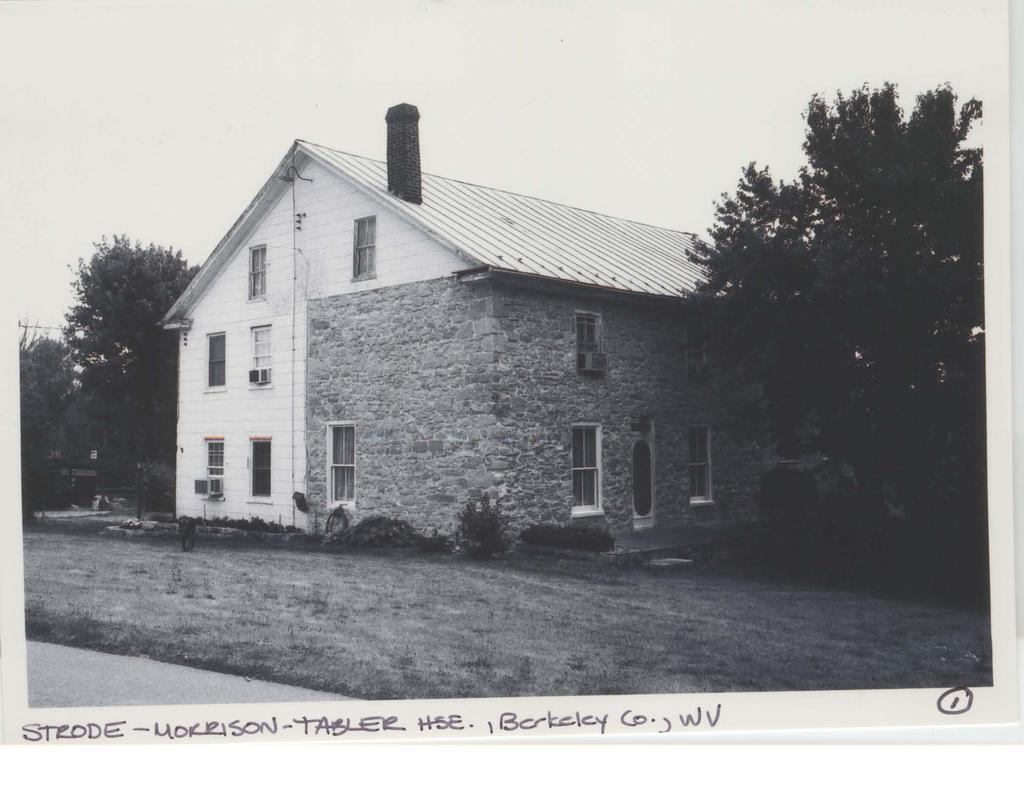
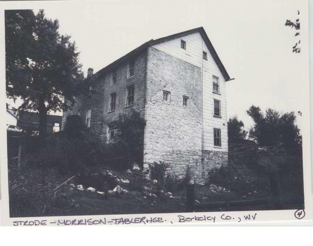
5 NPS Form a OMB Approval No United States Department of the Interior National Park Service National Register of Historic Places Continuation Sheet Strode-Morrison-Tabler House and Farm Name of Property Berkeley County, WV County/State Section Number 7 Page 1 Location and Setting The Strode-Morrison-Tabler House and Farm (Photos 1-18; Figs. 1-3) lies on a 125-acre tract in the Opequon District of Berkeley County, in West Virginia s rural Eastern Panhandle, approximately two miles northeast of the county seat of Martinsburg and one mile east of the unincorporated village of Bedington, northwest of the unincorporated village of Hedgesville and approximately one mile south of the Potomac River. The property stands at the end of Jacobs Road which runs eastward from Little Georgetown Road. The nominated property consists of a farmhouse, six adjacent contributing agricultural dependencies, and the contributing agricultural fields associated with the property at the close of the period of significance. Description Strode-Morrison-Tabler House c and after 1 contributing building The Strode-Morrison-Tabler House is a farmhouse of brick, limestone, and wood construction. (Photos 1-11). It is a vernacular 1 building which began as a modest c single-story, side-gable, two-bay cottage of rubble limestone (Photo 4) and underwent several additions, all within the period of significance. Judging from its appearance, a brick upper story was first added to the original house, soon to be joined by a three-bay c limestone addition constructed against the north gable end of the stone and brick house. This limestone addition became the principal section of the house as it presently exists. Later still, likely in the late nineteenth century, a wood frame addition was built along the rear of the house (Photos 1-4), finished in German siding and including a basement, two full stories above and a double-gallery porch. It appears that the roof was raised in conjunction with this latest addition. But for the cladding of the German siding with asbestos shingles (likely dating to the 1930s), all of this construction occurred in the nineteenth century; by the late nineteenth century, the property assumed the overall appearance which it retains. The Strode-Morrison-Tabler House is modestly detailed and lacks any formally-derived architectural ornament. The main entrance to the house is centered on the west elevation of the c. 1 The term, vernacular, as applied here, follows the definition found on page 512 of Ward Bucher s Dictionary of Building Preservation (New York: John Wiley, 1996) and refers to a building built without being designed by an architect or someone with similar formal training.
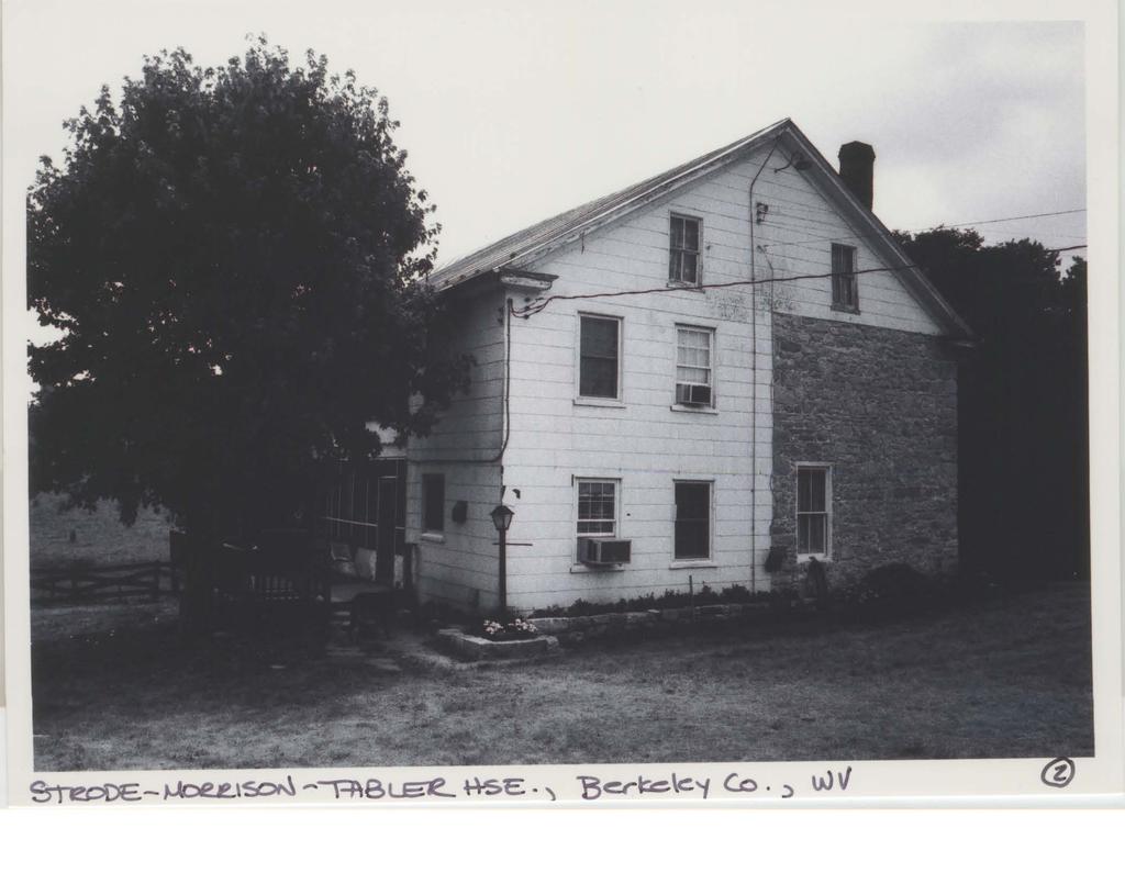
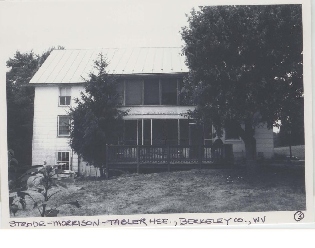
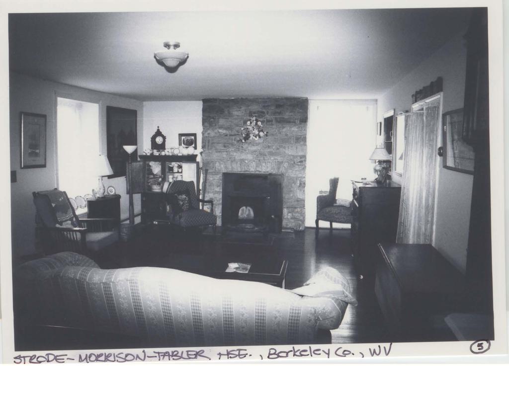
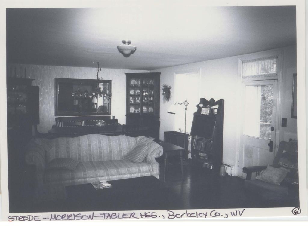
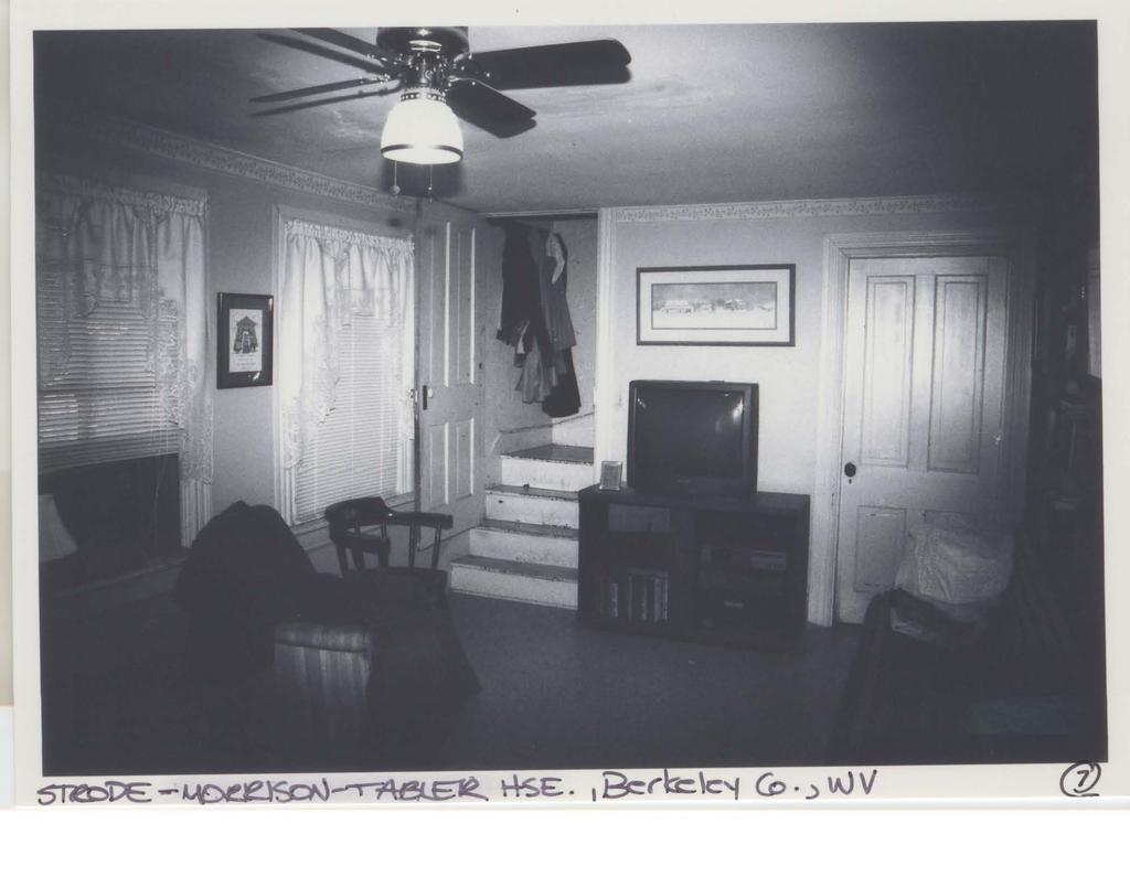
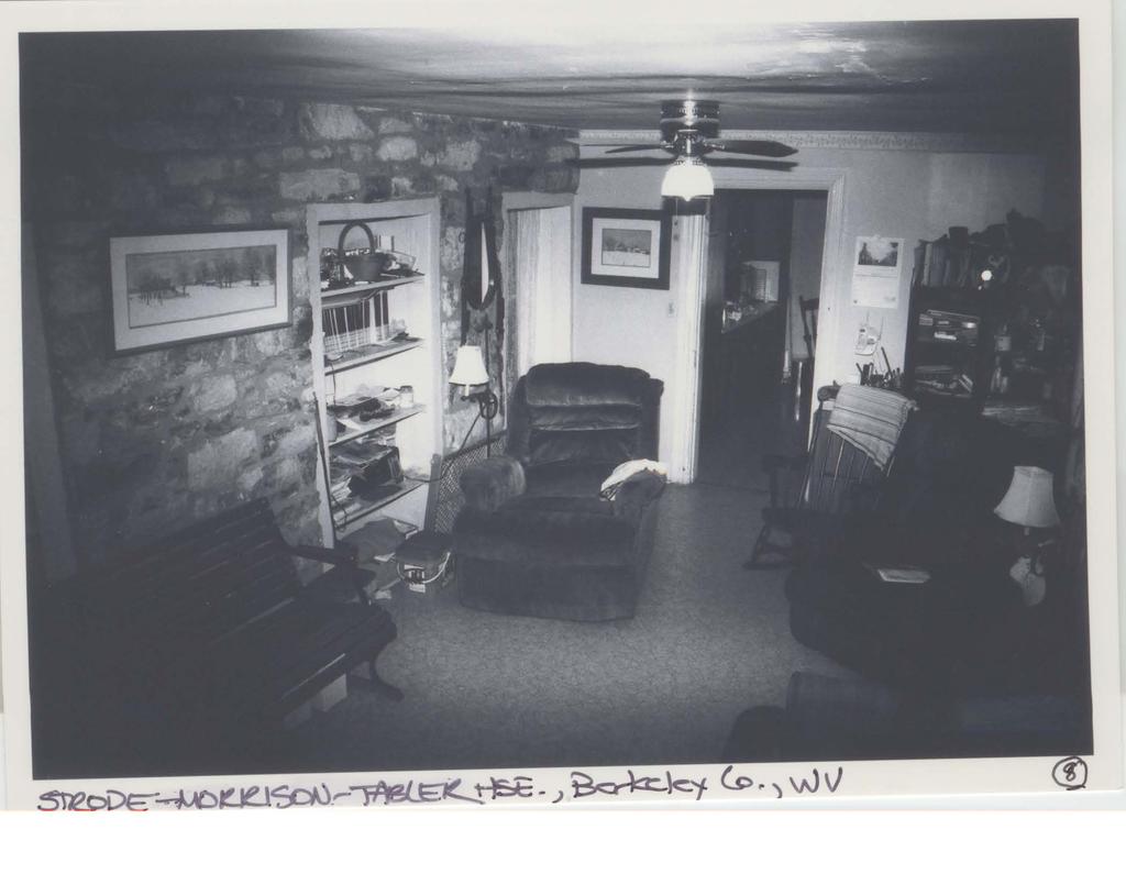
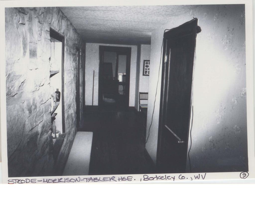
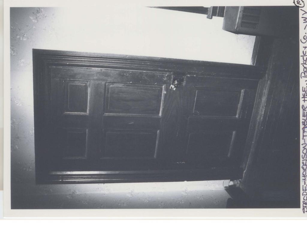
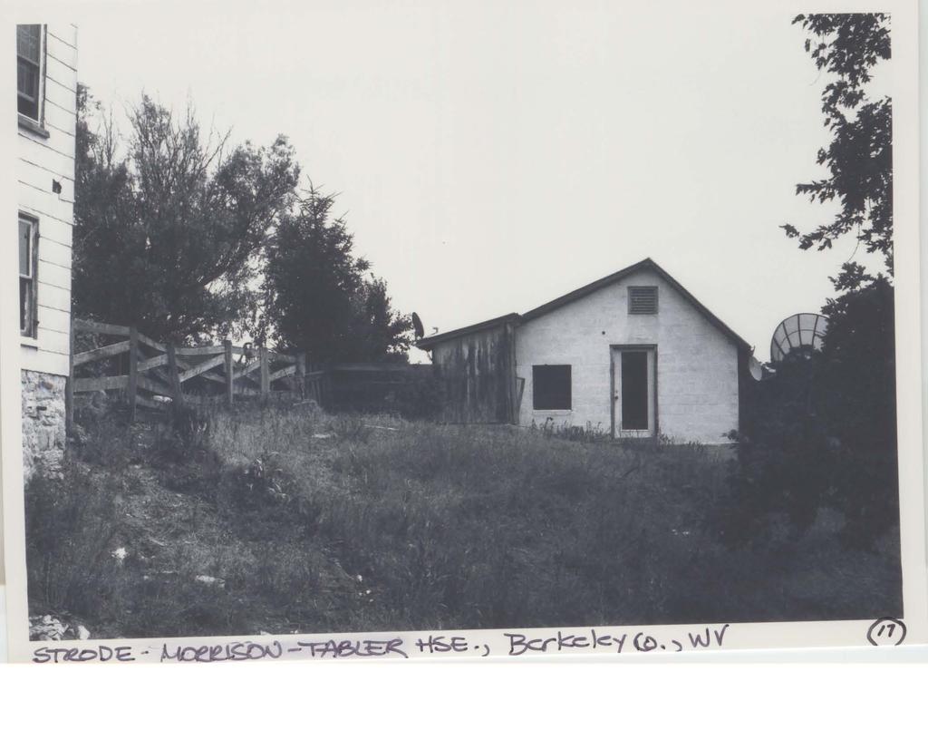
6 NPS Form a OMB Approval No United States Department of the Interior National Park Service National Register of Historic Places Continuation Sheet Strode-Morrison-Tabler House and Farm Name of Property Berkeley County, WV County/State Section Number 7 Page bay two-story stone section, incorporating a single wood door (Photo 1; Fig. 1). A historic photo (Fig. 1) shows the ghost of a front porch which once extended across this stone section; it is not extant. The corners of the three-bay stone section are trimmed with quoin-like stones considerably larger than the rubble used elsewhere in the construction of the house. The gable ends of the house exhibit partial returns of the cornice, somewhat derivative of the Greek Revival style, but more likely merely the result of vernacular building traditions in Berkeley County. Fenestration is flat-topped, with historic wood sash, generally two-over-two but with some six-over-six windows retained. A brick chimney serving the fireplace in the livingroom penetrates the front slope of the gable roof on the north elevation; the aforementioned historic view shows two other chimneys which were removed in the course of re-roofing the house. The east (rear) elevation includes a double-gallery porch, presently screened-in, and a modern wood deck projects outward away from the back porch (Photos 2, 3). Interior The interior of the house (Photos 5-11) is simple in its detailing. The earliest sections of the house--encompassing the original eighteenth-century limestone cottage and the brick upper stories-- contain two rooms on each floor, while the larger c limestone addition includes a room used as a livingroom/diningroom combination on the first story, with a large stone fireplace, and bedrooms above. The wood addition includes a sitting room and the kitchen on the first story and a bedroom and bathroom above, along with the double-gallery porch. The second story is accessed by an enclosed stair in the wood addition, suggesting that the earlier stair in the stone section was removed when the wood section was added. Walls are finished in plaster, except for portions of the sitting room and the secondfloor hallway which retain exposed stone finishes. Floors are of wood, some clad in sheet vinyl and others exposed. Window trim and baseboards have simply-molded profiles, doors are of a conventional paneled form (Photo 10), and the window reveals on the stone section are considerably deeper than those on the wood addition. Woodwork finishes vary: some are painted, others are varnished and some are grained. The basement is unfinished throughout. The following additional properties are associated with the Strode-Morrison-Tabler House and Farm, with numbers keyed to the site plan accompanying the nomination documents: 2. Shed c contributing building Tile and concrete block open-sided one-story garage/storage building, long and narrow in form, with
7 NPS Form a OMB Approval No United States Department of the Interior National Park Service National Register of Historic Places Continuation Sheet Strode-Morrison-Tabler House and Farm Name of Property Berkeley County, WV County/State Section Number 7 Page 3 a gable roof. It is located immediately north of the house. 3. Central aisle shed c contributing building Two-story gable-roofed central-aisle shed of wood construction 4. Barn complex c and after 1 contributing building Interconnected agricultural complex which includes a substantial timber frame-and-limestone bank barn set on a limestone foundation. The barn began as a considerably smaller limestone outbuilding, and portions of the limestone walls and gable end remain exposed. The barn was increased in size with a substantial timber frame addition. Appended to the barn are silos and a series of wood and concrete block additions, creating an irregular interconnected footprint. 5. Garage c contributing building Gable-end-oriented one-story wood garage located about fifty feet west of the house 6.Outbuilding c contributing building Laterally-oriented gable-roofed shed 7. Outbuilding c contributing building Wooden shed located approximately two hundred feet west of the house of indeterminate age and usage. Agricultural fields c and after 1 contributing site Agricultural fields, both fallow and in active production, which were historically associated with the subject property; also includes several stands of mature trees
8 NPS Form a OMB Approval No United States Department of the Interior National Park Service National Register of Historic Places Continuation Sheet Section Number 8 Page 4 Strode-Morrison-Tabler House and Farm Berkeley County, WV 8. Significance The Strode-Morrison-Tabler House and Farm is significant under National Register Criterion A for its reflection of exploration/settlement and early agricultural patterns in Berkeley County, West Virginia, and under Criterion C for architecture, as a mid-seventeenth-century Berkeley County vernacular stone farm house which was increased in size over many decades, with immediately adjacent agricultural dependencies. The period of significance of the property begins c when it appears that the first part of the house was erected by Edward Strode, and ends c. 1950, the approximate date of the most recently-constructed historic building erected on the farm. The property retains integrity and mirrors the advance of the agricultural industry in the county and the physical expansion both of the house and of its associated dependencies. The lands associated with the Strode-Morrison-Tabler House and Farm lay in the British colony of Virginia and first passed from royal ownership in 1734 when 360 acres were conveyed by King George to Morgan Bryan. Ten years later, Joseph Bryan acquired the property and later sold it to Edward Strode. It is thought that Edward Strode erected the first section of the house shortly after acquiring the land. In 1773 Edward Strode sold the property to Jeremiah Strode for 100. Jeremiah Strode amassed approximately 1,200 acres before his death c In his will he conveyed the property to his children, along with cattle, equipment, and one slave. 2 Lot 3 of his holdings included the nominated tract and contained 227¼ acres; it was bequeathed to his son and namesake. In 1801, William Morrison paid Jeremiah and Elizabeth Strode 1,030 for the 227-acre tract which they had inherited from the elder Jeremiah Strode. William Morrison likely built the brick upper story onto the earliest part of the house the small stone cottage shortly after acquiring the property in 1801, and during his ownership also added the larger three-bay stone addition, along with the original stone barn. Morrison farmed the tract for more than thirty years. He died c and in his will left his lands to his widow, to his sons Daniel B. and William, and daughter Hannah Chifley Morrison. Daniel Morrison remained on the home farm and in 1867, following his death, his executors, Thomas T. V. Quigley and A. F. Cramer, where charged with the disposal of his estate. For $15,000 they sold a certain tract of land, being the portion of the stone 2 Berkeley County Will Book 1, page 377.
9 NPS Form a OMB Approval No United States Department of the Interior National Park Service National Register of Historic Places Continuation Sheet Section Number 8 Page 5 Strode-Morrison-Tabler House and Farm Berkeley County, WV house farm lying south of the Scrabble and Lick Road containing 295 acres. 3 Tabler, in whose family the property would remain until The buyer was Levi Levi and Ruth Tabler reared their family in the house and likely added the wood section and double-gallery porch as their family grew. They became parents of sons George W., J. Calvin, and Elijah Tabler and daughter Ann, who eventually wed George Lemaster. Elijah Tabler acquired his siblings interest in the stone house and farm; his widowed mother was permitted to live in the brick portion of the house, described as containing four rooms and a kitchen. 4 In 1920, the farm passed out of the Tabler family when it was acquired first by John W. Jacobs (for whom Jacobs Road is named) and shortly thereafter by H. H. Emmert. Emmert lost the farm during the Depression and in 1944 it was acquired by Howard Sperow, whose son owned the property at the time of preparation of the nomination materials. With respect to Criterion A, the Strode-Morrison-Tabler House and Farm is significant as the reflection of the exploration and initial settlement of this portion of Berkeley County, Virginia, as the massive holdings of Lord Fairfax were being partitioned and sold off. The property also represents the agricultural patterns in Berkeley County beginning with the middle decades of the eighteenth century and continuing for two centuries thereafter. The farm was apparently run as a subsistence farm, supplying the needs of the immediate family. The farm produced crops--fodder for animals as well as food for the family--and also served as grazing lands for the farm animals upon which the families depended both for sustenance and as beasts of burden. The house, growing as it did from a modest cottage to a far more substantial farmhouse, illustrates the growth of prosperity of a series of Berkeley County farming families. This growth is also apparent in the main barn, which began as a relatively small limestone dependency and underwent several major additions as the agricultural economy matured. The property s Criterion C significance is supported by its presence as a mid-eighteenth-century stone dwelling, characteristic of the earliest vernacular building traditions of the Berkeley County section of West Virginia s eastern Panhandle. In addition, the barn, as it originally existed, typified the 3 Berkeley County Deed Book 63, Page Berkeley County Deed Book 78, Page 281.
10 NPS Form a OMB Approval No United States Department of the Interior National Park Service National Register of Historic Places Continuation Sheet Section Number 8 Page 6 Strode-Morrison-Tabler House and Farm Berkeley County, WV small-scale agricultural dependencies which were erected by Berkeley County pioneer farmers. As it presently exists, is characteristic of the type of bank barns which were being erected throughout the county during the nineteenth century.
11 NPS Form a OMB Approval No United States Department of the Interior National Park Service National Register of Historic Places Continuation Sheet Section Number 9 Page 7 Strode-Morrison-Tabler House and Farm Berkeley County, WV 9. Major Bibliographical References BIBLIOGRAPHY Berkeley County Public Records, Berkeley County Court House, Martinsburg, West Virginia. Kearfott, J. Baker. Berkeley County, West Virginia. [map] Martinsburg, Kearfott, Jonathan P. Map of Berkeley County, Virginia. [Martinsburg], McMurtry, David C., D. Ed., et al. In Search of the Strode Orphans. Varle, Charles. Map of Frederick, Berkeley, & Jefferson Counties Situated in the State of Virginia. Philadelphia: Benjamin Jones, West Virginia Historic Property Inventory Forms, Collection of the Berkeley County Historical Society, Martinsburg, West Virginia. Wood, Don C. William Morrison House, unpublished manuscript in the collection of the Berkeley County Historical Society, Martinsburg, West Virginia.
12 NPS Form a OMB Approval No United States Department of the Interior National Park Service National Register of Historic Places Continuation Sheet Section Number 10 Page 8 Strode-Morrison-Tabler House and Farm Berkeley County, WV 10. Geographical Data VERBAL BOUNDARY DESCRIPTION Being that acre tract depicted as Parcel Number 12 on Opequon District Map 4 of the Tax Assessment Maps for Berkeley County, West Virginia, as filed at the Berkeley County Court House, Martinsburg, West Virginia. This tract is described in Berkeley County Deed Book 528, Pages JUSTIFICATION The boundaries of this nomination consist of the Strode-Morrison-Tabler house, its associated agricultural and domestic dependencies, and the agricultural fields associated with the property at the close of the period of significance.
13 NPS Form a OMB Approval No United States Department of the Interior National Park Service National Register of Historic Places Continuation Sheet Section Number Photo Log Page 9 Strode-Morrison-Tabler House and Farm Berkeley County, WV PHOTOGRAPH LOG All Photographs: Strode-Morrison-Tabler House and Farm Berkeley County, West Virginia Photographer: David L. Taylor Date: 2005 Negatives filed at: West Virginia SHPO Charleston, West Virginia 1. NW perspective of house, looking SE, showing c stone section as well as late nineteenthcentury wood addition, fenestration, roof form, etc. 2. NE perspective, looking SW and showing rear addition and deck 3. E elevation, showing wood addition, double-gallery porch, and deck 4. SW perspective, looking NE,. Showing original c stone section, brick and wood additions, fenestration, etc. 5. Interior, livingroom, looking N toward fireplace and showing overall character, finishes, volume, etc. 6. Interior, livingroom, looking S with main door on right 7. Interior, wood addition, looking S and showing enclosed stair to second story, typical finishes, doors, etc. 8. Interior, wood addition, looking N from stair, showing exposed stone wall on left and door into kitchen in background 9. Interior, second story, hall, looking N and showing exposed stone wall on left and door to bathroom on right, bedroom in background
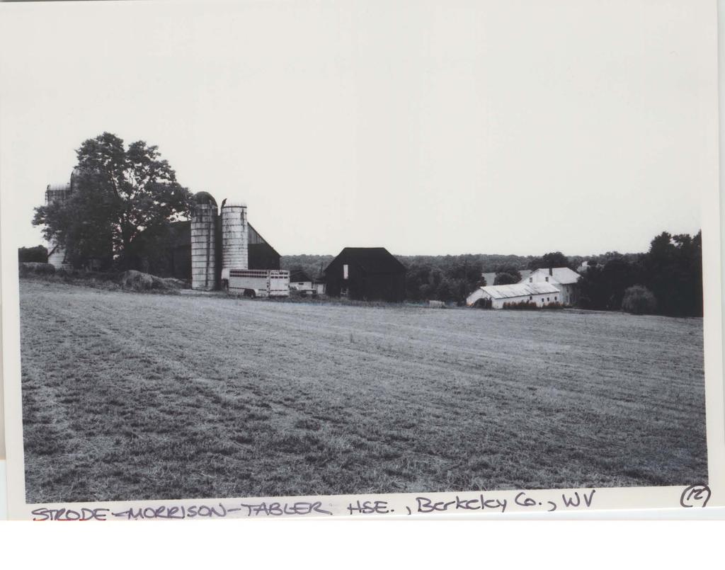
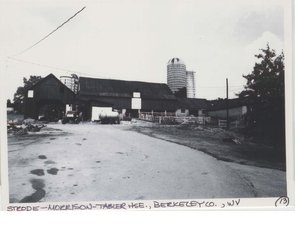
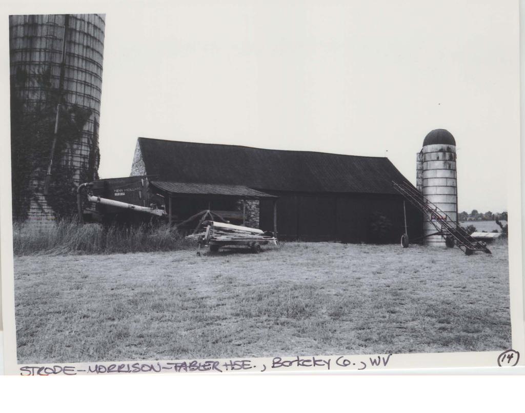
14 NPS Form a OMB Approval No United States Department of the Interior National Park Service National Register of Historic Places Continuation Sheet Section Number Photo Log Page 10 Strode-Morrison-Tabler House and Farm Berkeley County, WV 10. Interior, detail of door on second story, showing characteristic form and finishes 11. Interior, second story, bedroom in brick addition, typical view 12. View of barns and their relationship to house, looking S across agricultural fields 13. View of large barn and silos, looking N and showing central-aisle shed on the left 14. View of large barn, looking S, with original limestone section at left end of barn 15. Open-sided garage, looking NE 16. View of garage and concrete block storage building E of house, looking SE 17. Concrete block storage building E of house, looking E 18. Open-sided frame shed E of house, looking E

15 NPS Form a OMB Approval No United States Department of the Interior National Park Service National Register of Historic Places Continuation Sheet Section Number Illustrations Page 11 Strode-Morrison-Tabler House and Farm Berkeley County, WV Fig. 1 This undated photo shows the facade (W elevation) of the house associated with the nominated property, with the ghost of the front porch clearly visible.

16 NPS Form a OMB Approval No United States Department of the Interior National Park Service National Register of Historic Places Continuation Sheet Section Number Illustrations Page 12 Strode-Morrison-Tabler House and Farm Berkeley County, WV Fig. 2 This undated photo illustrates the SW perspective of the subject property. The pedimental windows of the original stone house appear mid-way up the gable end.

17 NPS Form a OMB Approval No United States Department of the Interior National Park Service National Register of Historic Places Continuation Sheet Section Number Illustrations Page 13 Strode-Morrison-Tabler House and Farm Berkeley County, WV Fig. 3 This c photo shows the concrete block opensided shed) apparently under construction, judging from the sky visible through the window in the pediment of the gable.

18 NPS Form a OMB Approval No United States Department of the Interior National Park Service National Register of Historic Places Continuation Sheet Section Number Illustrations Page 14 Strode-Morrison-Tabler House and Farm Berkeley County, WV Fig. 4 Charles Varle s county map shows the subject property, indicated by the superimposed arrow, as being under the ownership of William Morrison..
19 NPS Form a OMB Approval No United States Department of the Interior National Park Service National Register of Historic Places Continuation Sheet Section Number Illustrations Page 15 Strode-Morrison-Tabler House and Farm Berkeley County, WV Fig. 5 By 1847, when Jonathan Kearfott produced a new map of Berkeley County, the subject property, sown by the superimposed arrow, was in the ownership of the Tabler family.
20 NPS Form a OMB Approval No United States Department of the Interior National Park Service National Register of Historic Places Continuation Sheet Section Number Illustrations Page 16 Strode-Morrison-Tabler House and Farm Berkeley County, WV Fig. 6 family. The 1894 map of Berkeley County by J. Baker Kearfott, shows the property still in the hands of the Tabler
21
22
23 STRODE-MORRISON-TABLER HOUSE & FARM Berkeley County, West Virginia Tract Sketch Plan Legend: 1 house 2 tile shed 3 central-aisle shed 4 barn complex 5 garage 6 outbuilding 7 outbuilding -- agricultural fields
24
25
26
27
28
29
30
31
32
33
34
35
36
37
38
39
40
National Register of Historic Places Registration Form
 NPS Form 10-900 OMB No. 1024-0018 (Rev. 10-90) United States Department of the Interior National Park Service National Register of Historic Places Registration Form 1. Name of Property historic name Newcomer
National Register of Historic Places Registration Form
 NPS Form 10-900 OMB No. 1024-0018 (Rev. 10-90) United States Department of the Interior National Park Service National Register of Historic Places Registration Form 1. Name of Property historic name Evans,
National Register of Historic Places Registration Form
 NPS Form 10-900 OMB No. 1024-0018 (Rev. 10-90) United States Department of the Interior National Park Service National Register of Historic Places Registration Form 1. Name of Property historic name Elmwood-on-the-Opequon
National Register of Historic Places Registration Form
 NPS Form 10-900 OMB No. 10024-0018 (Oct. 1990) United States Department of the Interior National Park Service National Register of Historic Places Registration Form 1. Name of Property historic name Hickory
street & number: COUNTY ROUTE 3, HC-88, BOX 17 not for publication: N/A city/town: WHEELER vicinity: X state: WV county: WEBSTER code: 101 zip code:
 NPS Forn 10-900 OMB No. 10024-0018 (Oct. 1990) United States Department of the Interior National Park Service NATIONAL REGISTIR OF HISTORIC PLACES REGISTRATICN FCRX =========================================================---------=======
; * --.-.,., rj ; United States Department of the Interior \ ' '"] I National Park Service
![; * --.-.,., rj ; United States Department of the Interior \ ' '] I National Park Service](/thumbs/88/117765392.jpg "; * --.-.,., rj ; United States Department of the Interior \ ' '] I National Park Service") NPS Form 10-900 OMB No. 1024-0018 (Rev. 10-90) : / i' -_ :. - : ; ; * --.-.,., rj ; United States Department of the Interior \ ' '"] I National Park Service NATIONAL REGISTER OF HISTORIC PLACES REGISTRATION
NPS Form 10-900 OMB No. 1024-0018 (Rev. 10-90) : / i' -_ :. - : ; ; * --.-.,., rj ; United States Department of the Interior \ ' '"] I National Park Service NATIONAL REGISTER OF HISTORIC PLACES REGISTRATION
 Page 1 Original Update HISTORICAL STRUCTURE FORM FLORIDA MASTER SITE FILE Consult Guide To Historical Structure Forms for detailed instructions Site # 8OR9844 Recorder # 26 Recorder Date 2/20/08 Site Name
Architectural Inventory Form
 OAHP1403 Rev. 9/98 COLORADO CULTURAL RESOURCE SURVEY Architectural Inventory Form Official eligibility determination (OAHP use only) Date Initials Determined Eligible- NR Determined Not Eligible- NR Determined
NPS Form OMB No (Oct. 1990)
") NPS Form 10-900 OMB No. 10024-0018 (Oct. 1990) United States Department of the Interior National Park Service NATIONAL REGISTER OF HISTORIC PLACES REGISTRATION FORM 1. Name of Property historic name:_lost
NPS Form 10-900 OMB No. 10024-0018 (Oct. 1990) United States Department of the Interior National Park Service NATIONAL REGISTER OF HISTORIC PLACES REGISTRATION FORM 1. Name of Property historic name:_lost
Maryland Historical Trust Inventory No. PG: 86A-026 Maryland Inventory of Historic Properties Form
 Inventory No. PG: 86A-026 Maryland Inventory of 1. Name of Property (indicate preferred name) historic other 2. Location street and number 12811 Croom Road not for publication city, town Naylor vicinity
National Register of Historic Places Registration Form
 NPS Form 10-900 OMB No. 10024-0018 (Oct. 1990) Registration Form This form is for use in nominating or requesting determinations for individual properties and districts. See instructions in How to Complete
United States Department of the Interior National Park Service NATIONAL REGISTER OF HISTORIC PLACES REGISTRATION FORM. Wilmoth, Bernard E.
 NPS Form 10-900 OMB No. 10024-0018 (Oct. 1990) United States Department of the Interior National Park Service NATIONAL REGISTER OF HISTORIC PLACES REGISTRATION FORM 1. Name of Property historic name: other
United States Department of the Interior National Park Service NATIONAL REGISTER OF HISTORIC PLACES REGISTRATION FORM
 NPS Form 10-900 (Rev. 8-86) OMB No. 1024-0018 United States Department of the Interior National Park Service NATIONAL REGISTER OF HISTORIC PLACES REGISTRATION FORM other name/site number: "Maple Shadows:"
National Register of Historic Places Registration Form
 NPS Form 10-900 OMB No. 10024-0018 (Oct. 1990) United States Department of the Interior National Park Service National Register of Historic Places Registration Form 1. Name of Property historic name other
National Register of Historic Places Registration Form
 NPS Form 10-900 OMB No. 10024-0018 (Oct. 1990) Registration Form This form is for use in nominating or requesting determinations for individual properties and districts. See instructions in How to Complete
1 buildings sites structures objects 1 0 TOTAL
 Name of Property County and State 4. National Park Service Certification --------- I, hereby certify that this property is: Signature of Keeper Date of Action entered in the National Register See continuation
NATIONAL REGISTER OF HISTORIC PLACES REGISTRATION FORM
 NPS Form 10-900 OMB No. 1024-0018 (Rev. 10-90) United States Department of the Interior National Park Service NATIONAL REGISTER OF HISTORIC PLACES REGISTRATION FORM 1. Name of Property historic name Compton-Johnson
National Register of Historic Places Registration Form
 NPS Form 10-900 OMB No. 10024-0018 (Oct. 1990) Registration Form This form is for use in nominating or requesting determinations for individual properties and districts. See instructions in How to Complete
United States Department of the Interior National Park Service NATIONAL REGISTER OF HISTORIC PLACES REGISTRATION FORM
 NPS Form 10-900 (Oct. 1990) OMB No. 10024-0018 United States Department of the Interior National Park Service NATIONAL REGISTER OF HISTORIC PLACES REGISTRATION FORM 1. DR JOHN C. IRONS RESIDENCE hlstoric
United States Department of the Interior National Park Service NATIONAL REGISTER OF HISTORIC PLACES REGISTRATION FORM
 NPS Form 10-900 (Oct. 1990) OMB NO. 10024-0018 United States Department of the Interior National Park Service NATIONAL REGISTER OF HISTORIC PLACES REGISTRATION FORM As the designated authority under the
Appendix D Reevaluation of Structures on Bock House Property
 Appendix D Reevaluation of Structures on Bock House Property Page 1 Original Update HISTORICAL STRUCTURE FORM FLORIDA MASTER SITE FILE Consult Guide To Historical Structure Forms for detailed instructions
NPS Form OMB No Exp Status occupied X unoccupied work in progress Accessible yes: restricted yes: unrestricted _5Lno
 NPS Form 10-900 OMB No. 1024-0018 Exp. 10-31-84 United States Department of the Interior National Park Service National Register of Historic Places Inventory Nomination Form See instructions in How to
AH pp. I Ti. Nov 7 I) I I y
 I I y") ..------------------------------------------ ------------ - - -- - NPS Form 10-900 (Rev. 8-86) United States Department of the Interior ~a tional Park Service NATIONAL REGISTER OF HISTORIC PLACES REGISTRATION
..------------------------------------------ ------------ - - -- - NPS Form 10-900 (Rev. 8-86) United States Department of the Interior ~a tional Park Service NATIONAL REGISTER OF HISTORIC PLACES REGISTRATION
Address 347 Whitney Street. East elevation, camera facing southwest.
 FORM B BUILDING Assessor s Number USGS Quad Area(s) Form Number MASSACHUSETTS HISTORICAL COMMISSION MASSACHUSETTS ARCHIVES BUILDING 220 MORRISSEY BOULEVARD BOSTON, MASSACHUSETTS 02125 Town Northborough
National Register of Historic Places Registration Form
 NPS Form 10-900 OMB No. 1024-0018 (Expires 5/31/2012) United States Department of the Interior National Register Listed National Park Service May 1, 2012 National Register of Historic Places Registration
Commonwealth of Massachusetts Massachusetts Historical Commission 220 Morrissey Boulevard, Boston, Massachusetts
 Inventory No: Historic Name: Common Name: Address: HRV.165 Blood, Joseph House Farnsworth, Jonathan - Beaman, Jonathan House 74 Poor Farm Rd City/Town: Village/Neighborhood: Local No: 9-17 Year Constructed:
National Register of Historic Places Registration Form
 NPS Form 10-900 OMB No. 1024-0018 (Expires 5/31/2012) United States Department of the Interior National Register Listed National Park Service May 1, 2012 National Register of Historic Places Registration
ate: AR County: Pulaski Code: AR Zip Code: Noncontributing buildings sites structures objects Total
 Mims-Ereedlove-Priest-Weatherton House Name of Property Little Rock, AR County and State ~- -,s Form 10-900 'V. 8-86) OMB No. 1024-0018 United States Department of the Interior National Park Service NATIONAL
National Register of Historic Places Registration Form
 National Park Service National Register of Historic Places Registration Form This form is for use in nominating or requesting determinations for individual properties and districts. See instructions in
NE¼ of NE¼ of NE¼ of NE¼ of section Roof configuration (enter one): Gabled Roof / Front Gabled Roof
: Gabled Roof / Front Gabled Roof") OAHP1403 Rev. 9/98 COLORADO CULTURAL RESOURCE SURVEY Official Eligibility Determination (OAHP use only) Date Initials Determined Eligible - National Register Architectural Inventory Form Determined Not
OAHP1403 Rev. 9/98 COLORADO CULTURAL RESOURCE SURVEY Official Eligibility Determination (OAHP use only) Date Initials Determined Eligible - National Register Architectural Inventory Form Determined Not
301 7½ Street SW
 301 7½ Street SW 104-0213-0072 Primary Resource Information: Single Dwelling, Stories 2.00, Style: Other, ca 1890 July 2006: This late-19th-century, 3-bay, 2-story, hip-roofed frame I-house features projecting
NATIONAL REGISTER OF HISTORIC PLACES REGISTRATION FORM
 (Rev. 10-90) NPS Form 10-900 OMB No. 1024-0018 NATIONAL REGISTER OF HISTORIC PLACES REGISTRATION FORM This form is for use in nominating or requesting determinations for individual properties and districts.
National Register of Historic Places Registration Form
 National Park Service National Register of Historic Places Registration Form This form is for use in nominating or requesting determinations for individual properties and districts. See instructions in
Maryland Historical Trust Inventory No. PG: 75A-007 Maryland Inventory of Historic Properties Form
 Inventory No. PG: 75A-007 Maryland Inventory of 1. Name of Property (indicate preferred name) historic other 2. Location street and number 3101 Ritchie Road not for publication city, town Forestville vicinity
United States Department of the Interior National Park Service. Boundary Expansion Listed in National Register January 11, 2017
 NPS Form 10900-a (Rev. 8/2002) OMB No. 10240018 United States Department of the Interior National Park Service Boundary Expansion Listed in National Register January 11, 2017 National Register of Historic
AHPP. LISTED ========================================================================
 NPS Form 10-900 (Rev. 8-86) Jnited States Department of the Interior ational Park Service OMB No. 1024-0018 LISTED NATIONAL REGISTER OF HISTORIC PLACES REGISTRATION FORM AHPP. 1. Historic Name: Bush-Dubisson
D not for publication D vicinity
 NPS Fonn I 0-900 (Oct. 1990) OMB No. 10024-0018 United States Department of the Interior National Park Service National Register of Historic Places Registration Form This fom1 is for use in nominating
Appendix E Historic Property Inventory Forms
 Appendix E Historic Property Inventory Forms TECHNICAL MEMORANDUM Sound Transit Federal Way Link Extension WISAARD Survey Entries PREPARED FOR: COPY TO: PREPARED BY: Sound Transit Alisa Swank/ CH2M MaryNell
FLAGLER WORKER S HOUSE FORT DALLAS PARK S.E. 4 STREET
 FLAGLER WORKER S HOUSE FORT DALLAS PARK 60-64 S.E. 4 STREET Designation Report City of Miami REPORT OF THE CITY OF MIAMI PLANNING DEPARTMENT TO THE HERITAGE CONSERVATION BOARD ON THE POTENTIAL DESIGNATION
Maryland Historical Trust Inventory No. PG: 86A-003 Maryland Inventory of Historic Properties Form
 Inventory No. PG: 86A-003 Maryland Inventory of 1. Name of Property (indicate preferred name) historic other 2. Location street and number 12005 Duley Station Road not for publication city, town Upper
National Register of Historic Places Registration Form
 NPS Form 10-900 OMB No. 10024-0018 (Oct. 1990) Registration Form This form is for use in nominating or requesting determinations for individual properties and districts. See instructions in How to Complete
- request for determination of eligibility meets the documentation
 NPS Form 10-900 OMB No. 10024-0018 (Oct. 1990) United States Department of the Interior National Park Service NATIONAL REGISTER OF HISTORIC PLACES REGISTRATION FORM historic name: Reed's Mill other name/site
United States Department of the Interior National Park Service NATIONAL REGISTER OF HISTORIC PLACES REGISTRATION FORM
 NPS Form 10-900 OMB No. 10024-0018 (Oct. 1990) United States Department of the Interior National Park Service NATIONAL REGISTER OF HISTORIC PLACES REGISTRATION FORM 1. Name of Property historic name: other
Maryland Historical Trust Inventory No Maryland Inventory of Historic Properties Form
 Inventory No. 15 28 Maryland Inventory of 1. of Property (indicate preferred name) historic Luther Moore Farm other 2. Location street and number 7201 Damascus Road not for publication city, town Gaithersburg
Maryland Historical Trust Inventory No. PG: 81B-008 Maryland Inventory of Historic Properties Form
 Maryland Historical Trust Inventory No. PG: 81B-008 Maryland Inventory of 1. Name of Property (indicate preferred name) historic other 2. Location Dyson Farmhouse (preferred) street and number 13010 Piscataway
Maryland Historical Trust Inventory No. 15/6 Maryland Inventory of Historic Properties Form
 Inventory No. 15/6 Maryland Inventory of 1. Name of Property (indicate preferred name) historic Becraft Farm other 2. Location street and number 28500 Ridge Road not for publication city, town Mount Airy
Current Functions (Enter categories from instructions) Materials (Enter categories from instructions)
 Materials (Enter categories from instructions)") Site Inventory Form State Inventory No. 92-00542 New Supplemental State Historical Society of Iowa Part of a district with known boundaries (enter inventory no.) 92-00349 (November 2005) Relationship:
Site Inventory Form State Inventory No. 92-00542 New Supplemental State Historical Society of Iowa Part of a district with known boundaries (enter inventory no.) 92-00349 (November 2005) Relationship:
THE BARNACLE 3485 MAIN HIGHWAY
 THE BARNACLE 3485 MAIN HIGHWAY Designation Report City of Miami REPORT OF THE CITY OF MIAMI PLANNING AND ZONING DEPARTMENT TO THE HISTORIC AND ENVIRONMENTAL PRESERVATION BOARD ON THE POTENTIAL DESIGNATION
National Register of Historic Places Inventory Nomination Form
 NPS Form 10-900-a Exp. 10-31-84 Continuation sheet 4 5 item number 7 Page 45 NAME: Knight Estate LOCATION: 486 East Avenue,,--v..u^-^ OWNER: State of Rhode Island Department of Education Board of Regents
DESIGNATION REPORT KENNEDY-BAKER-WALKER-SHERRILL HOUSE (1849) 9320 KINGSTON PIKE (CLT ) KNOXVILLE, TENNESSEE July 12, 2007
 9320 KINGSTON PIKE (CLT ) KNOXVILLE, TENNESSEE July 12, 2007") DESIGNATION REPORT KENNEDY-BAKER-WALKER-SHERRILL HOUSE (1849) 9320 KINGSTON PIKE (CLT 132-027) KNOXVILLE, TENNESSEE July 12, 2007 Description The Kennedy-Baker-Walker-Sherrill House is located on the south
DESIGNATION REPORT KENNEDY-BAKER-WALKER-SHERRILL HOUSE (1849) 9320 KINGSTON PIKE (CLT 132-027) KNOXVILLE, TENNESSEE July 12, 2007 Description The Kennedy-Baker-Walker-Sherrill House is located on the south
United States Department of the Interior National Park Service YATIONAL REGISTER OF HISTORIC PLACES REGISTRATION FORM
 NPS Form 10-900 (Oct. 1990) OMB No. 10024-00l'8 United States Department of the Interior National Park Service YATIONAL REGISTER OF HISTORIC PLACES REGISTRATION FORM 1. Yame of Property HAMILTON, LMARTIN,
1 Gildersleeve Wood (DHR # )
") GILDERSLEEVE WOOD 1 Gildersleeve Wood (DHR # 104-5092-0012) STREET ADDRESS: 1 Gildersleeve Wood MAP & PARCEL: 11-20 PRESENT ZONING: R-1U ORIGINAL OWNER: Lindsay Family ORIGINAL USE: PRESENT USE: PRESENT
GILDERSLEEVE WOOD 1 Gildersleeve Wood (DHR # 104-5092-0012) STREET ADDRESS: 1 Gildersleeve Wood MAP & PARCEL: 11-20 PRESENT ZONING: R-1U ORIGINAL OWNER: Lindsay Family ORIGINAL USE: PRESENT USE: PRESENT
ATTACHMENT C ARLINGTON COUNTY REGISTER OF HISTORIC PLACES HISTORIC DISTRICT DESIGNATION FORM
 1. NAME OF PROPERTY ARLINGTON COUNTY REGISTER OF HISTORIC PLACES HISTORIC DISTRICT DESIGNATION FORM Historic Name: Other names: Reevesland Torreyson Farm 2. LOCATION OF PROPERTY Street and Number: 400
Total 1 Total. Current Functions (Enter categories from instructions) Materials (Enter categories from instructions)
 Materials (Enter categories from instructions)") Site Inventory Form State Inventory No. 29-00962 New Supplemental State Historical Society of Iowa Part of a district with known boundaries (enter inventory no.) 29-03685 (November 2005) Relationship:
Site Inventory Form State Inventory No. 29-00962 New Supplemental State Historical Society of Iowa Part of a district with known boundaries (enter inventory no.) 29-03685 (November 2005) Relationship:
CHRONOLOGY & DEVELOPMENT BOUDINOT-SOUTHARD PROPERTY BASKING RIDGE, NJ OF THE
 CHRONOLOGY & DEVELOPMENT OF THE BOUDINOT-SOUTHARD PROPERTY BASKING RIDGE, NJ Elias Boudinot 1740 Elias Boudinot born May 2 in Philadelphia, where his family was a neighbor of Benjamin Franklin. 1760 Boudinot
United States Department of the Interior National Park Service NATIONAL REGISTER OF HISTORIC PLACES REGISTRATION FORM
 NPS Form 10-900 (Oct. 1990) OMB NO. 10024-0018 United States Department of the Interior National Park Service NATIONAL REGISTER OF HISTORIC PLACES REGISTRATION FORM 1. historic name: WEIMER, JAMES HOUSE
 ~. ',. ( NPS Form 10-900 (Rev. 8-86) NR I ;s+eca Cf/ S /q~ OMB No. 1024-0018 United States Department of the Interior National Park Service NATIONAL REGISTER OF HISTORIC PLACES REGISTRATION FORM ------------------------------------------------------------------------
Maryland Historical Trust Inventory No. PG: Maryland Inventory of Historic Properties Form
 Inventory No. PG: 62-012 Maryland Inventory of 1. Name of Property (indicate preferred name) historic other 2. Location street and number 11205 Old Baltimore Pike not for publication city, town Beltsville
BROUGHTON GROVE FARMHOUSE, FIELD BROUGHTON. An investigation using documentary evidence.
 BROUGHTON GROVE FARMHOUSE, FIELD BROUGHTON. An investigation using documentary evidence. Location of house. Grove Farmhouse (BGF) is in the hamlet of Field which is 2 miles north of. Access is via a track
Fletchertown (71A-022)
") Fletchertown (71A-022) Fletchertown is a late-nineteenth-century rural African-American community in northeastern Prince George s County. The community is located south of Huntington and northwest of Bowie.
Fletchertown (71A-022) Fletchertown is a late-nineteenth-century rural African-American community in northeastern Prince George s County. The community is located south of Huntington and northwest of Bowie.
NATIONAL REGISTER OF HISTORIC PLACES REGISTRATION FORM
 (Rev. 10-90) NPS Form 10-900 OMB No. 1024-0018 NATIONAL REGISTER OF HISTORIC PLACES REGISTRATION FORM This form is for use in nominating or requesting determinations for individual properties and districts.
N/A not for publication city or town : Hillsboro - X vicinity state: West Virginia code: WV countv: Pocahontas code: 075 zip code: 24946
 United States Department of the Interior National Park Service historic name : other nameslsite number : NIA. -.- 2. Location street & number : HC 64. Box 147loff County Road 3 1 on Kyle Beard Road N/A
New Orleans Historic District Landmarks Commission Nomination Report 210 State Street, former NOAH Campus July 17, 2014
 New Orleans Historic District Landmarks Commission Nomination Report 210 State Street, former NOAH Campus July 17, 2014 Meeting Date: July 17, 2014 Property Address: Owner: 210 State Street Children s
not for publication: N/A city/town: St. Albans vicinity: N/A state: WV county : Kanawha code: 039 zip code:25177
 #PS F o 10-900 ~ OMB NO. 10024-0018 (OC~. 1990) United States Department of the Interior National Park Service LSATIOHAL REGISTER OF HISTORIC PLACES REGISTRATION FORM 1. Name of Property ST. ALBANS CHESAPEAKE
Name of related multiple property listing: Historic and Architectural Resources in Abilene, Texas
 NPS Form 10-900 (Rev. 8-86) United States Department of the Interior National Park Service NATIONAL REGISTER OF HISTORIC PLACES REGISTRATION FORM 1. NAME OF PROPERTY Historic name: Magee, J.D., House Other
MINNESOTA HISTORIC.PROPERTIES INVENTORY FORM. Yes_ No X Restricted
 HISTORIC NAME: CURRENT NAME: LEGAL DESC.: MINNESOTA HISTORIC.PROPERTIES INVENTORY FORM Hartley Sugar Camp W % of Gov't. Lot 3 and T55, R24, Sec. 9 COUNTY: Itasca CITY/TWP.: Trout Lake Twp. ADDRESS: of
Commonwealth of Massachusetts Massachusetts Historical Commission 220 Morrissey Boulevard, Boston, Massachusetts
 Inventory No: Historic Name: Common Name: Address: HRV.173 Rand, Jonathan House and Farm Taylor, William Jr. - Barnard, Ephraim House 44 Littleton County Rd City/Town: Village/Neighborhood: Local No: 23-20,21
NPS Form OMB No (Rev ) U. S. Department of the Interior Name of Property: Hungry Mother State Park Historic District
 U. S. Department of the Interior Name of Property: Hungry Mother State Park Historic District") NPS Form 10-900 OMB No. 1024-4018 (Rev. 10-90) U. S. Department of the Interior Name of Property: Location: 5. Classification Ownership of Property (Check as many boxes as apply) Category of Property (Check
NPS Form 10-900 OMB No. 1024-4018 (Rev. 10-90) U. S. Department of the Interior Name of Property: Location: 5. Classification Ownership of Property (Check as many boxes as apply) Category of Property (Check
808 Cherry Avenue
 808 Cherry Avenue 104-0213-0059 Primary Resource Information: Single Dwelling, Stories 2.00, Style: Other, ca 1900 July 2006: This 2-story, 3-bay frame I-house features a central-front gable, a brick pier
in 7.x M (Oct. 1990) United States Department of the Interior National Park Service 1. NAME OF PROPERTY
 United States Department of the Interior National Park Service 1. NAME OF PROPERTY") (Oct. 1990) United States Department of the Interior National Park Service NATIONAL REGISTER OF HISTORIC PLACES REGISTRATION FORM 1. NAME OF PROPERTY HISTORIC NAME: Jacala Restaurant OTHER NAME/SITE NUMBER:
(Oct. 1990) United States Department of the Interior National Park Service NATIONAL REGISTER OF HISTORIC PLACES REGISTRATION FORM 1. NAME OF PROPERTY HISTORIC NAME: Jacala Restaurant OTHER NAME/SITE NUMBER:
HENNIGAN PLACE. This photograph is circa November Name, address, and telephone number of the present owner and occupant of the property:
 HENNIGAN PLACE This report was written on November 7, 1979 This photograph is circa November 2006. 1. Name and location of the property: The property known as the Hennigan Place is located at 3503 Tilley
Town: Sharon Place (neighborhood or village): Sharon. ame of Area: Present Use: Date (month / year): July 2008
: Sharon. ame of Area: Present Use: Date (month / year): July 2008") FORM A - AREA MASSACHUSETTS HISTORICAL COMMISSION MASSACHUSETTS ARCHIVES BUILDING 220 MORRISSEY BOULEVARD BOSTON, MASSACHUSETTS 02125 Photograph Assessor s Sheets USGS Quad Area Letter Form Numbers in
FORM A - AREA MASSACHUSETTS HISTORICAL COMMISSION MASSACHUSETTS ARCHIVES BUILDING 220 MORRISSEY BOULEVARD BOSTON, MASSACHUSETTS 02125 Photograph Assessor s Sheets USGS Quad Area Letter Form Numbers in
National Register of Historic Places Continuation Sheet
 NFS Form 10-900-a OMB Approval No. 1024-0018 (8-86) United States Department of the Interior National Register of Historic Places Continuation Sheet Section number Page SUPPLEMENTARY LISTING RECORD NRIS
United States Department of the Interior National Park Service NATIONAL REGISTER OF HISTORIC PLACES REGISTRATION FORM
 NPS Form 10-900 (Oct. 1990) OMB No. 10024-0018 United States Department of the Interior National Park Service NATIONAL REGISTER OF HISTORIC PLACES REGISTRATION FORM 1. historic name: Stone Manse other
I Signature of commenting official Date I. / Title State or Federal agencylbureau or Tribal Government 1
 National Park Service National Register of Historic Places Registration Form LISTED ON: VLR 09/20/2012 NRHP 11/20/2012 This form is for use in nominating or requesting determinations for individual properties
Langley Register of Historic Places Nomination Form
 FOR OFFICE USE ONLY Langley Register of Historic Places Nomination Form Received Type all entries 1. Name of Property Historic: Jacob Anthes Bunkhouse/Cookhouse And/or common: South Whidbey Historical
National Register of Historic Places Registration Form
 NPS Form 10-900 OMB No. 10024-0018 (Oct. 1990) United States Department of the Interior National Park Service National Register of Historic Places Registration Form 1. Name of Property historic name other
National Register of Historic Places Registration Form
 NPS Form 10-900 (Oct. 1990) OMB NO. 10024-0018 Registration Form This form is for use in nominating or requesting determinations for individual properties and districts. See instructions in How to Complete
First Floor Plan. Second Floor Plan
 The Flint Homestead was built by 1709 for Ephraim Flint (1641 1723) and his wife Jane Bulkeley. They did not have any children. In 1723 he willed his mansion house to his nephew, John Flint, and to John
National Register of Historic Places Registration Form
 NPS Form 10-900 (Rev. 01/2009) OMB No. 1024-0018 United States Department of the Interior National Park Service National Register of Historic Places Registration Form This form is for use in nominating
... street & number: U.S. Rt. 219
 NPS Form 10-900 (Rev. 8-86) OMB NO. 1024-0018 United States Department of the Interior National Park Service NATIONAL REGISTER OF HISTORIC PLACES REGISTRATION FORM other name/site number: N/A 2. Location...
Agriculture; Architecture; Community Planning
 Inventory No: Historic Name: SBR.Q Bemis - LaurEdo Farm Common Name: Address: City/Town: Village/Neighborhood: Local No: Year Constructed: Architect(s): Architectural Style(s): Use(s): Significance: Agricultural;
National Register of Historic Places Registration Form
 NPS Form 10-900 (Oct. 1990) OMB No. 10024-0018 United States Department of the Interior 'fonal Park Service National Register of Historic Places Registration Form This form is for use in nominating or
AHPP. ======================================================================== 3. Classi fication
 NPS Form 10-900 (Rev. 8-86) OMB No. 1024-0018 inited States Department of the Interior ational Park Service NATIONAL REGISTER OF HISTORIC PLACES REGISTRATION FORM I r' '- AHPP 1. Historic Name: Thornton
National Register of Historic Places Continuation Sheet
 Section number N/A Page 1 Proposed Amendment to Wichita, Sedgwick County, Kansas The owner of the building at 141 S. Rock Island Avenue requests amendment to the boundaries of the East Douglas Historic
county Lonoke code 085 zip code
 ~~~~~~~~~~~ AR NPS Form I 0-900 (Oct. 1990) United States Department of the Interior National Park Service National Register of Historic Places egistration Form w-l.3-1 / OMB No. 10024-0018 This form is
NATIONAL RIEGISTER OF HISTORIC PLACES REGISTRATION FO _
 NPS Form 10-900 (Rev. 10-90) NATIONAL RIEGISTER OF HISTORIC PLACES REGISTRATION FO This form is for use in nominating or requesting determinations for individual properties and districts. See instructions
Document 1-Archaeological Investigation
 Document 1-Archaeological Investigation A limestone double flue central chimney (See Figure #3), DHR 21-550-18, the remains of a domestic (house like) structure located within the southeast corner of the
HISTORIC SITE FORM HISTORIC SITES INVENTORY
 HISTORIC SITE FORM HISTORIC SITES INVENTORY 1 IDENTIFICATION Name of Property: House at 569 Park Avenue PARK CITY MUNICIPAL CORPORATION (10-08) Address: 569 Park Avenue City, County: Park City, Summit
HISTORIC DISTRICT STUDY COMMITTEE REPORT GEORGE FARMSTEAD HISTORIC DISTRICT OAKLAND TOWNSHIP, MICHIGAN
 HISTORIC DISTRICT STUDY COMMITTEE REPORT GEORGE FARMSTEAD HISTORIC DISTRICT OAKLAND TOWNSHIP, MICHIGAN HISTORIC DISTRICT STUDY COMMITTEE REPORT GEORGE FARMSTEAD HISTORIC DISTRICT OAKLAND TOWNSHIP, MICHIGAN
- removed from the National Register. - See continuation sheet. - Domestic: Sinsle Dwellins Current : Work in Prosress Sub :
 4. State/Federal Agency Certification... As the desiqnated authority under the National Historic Preservation Act of 1986, as-amended, I hereby certify that this nomination request for determination of
city or town Muscatine vicinity, county Muscatine Legal Description: (If Rural) Township Name Township No. Range No. Section Quarter of Quarter
 Township Name Township No. Range No. Section Quarter of Quarter") Site Inventory Form State Inventory No. 70-00233 New Supplemental State Historical Society of Iowa Part of a district with known boundaries (enter inventory no.) (December 1, 1999) Relationship: Contributing
Site Inventory Form State Inventory No. 70-00233 New Supplemental State Historical Society of Iowa Part of a district with known boundaries (enter inventory no.) (December 1, 1999) Relationship: Contributing
1 Title State or Federal agencylbureau or Tribal Government national - statewide X local
 NPS Form 10-900 OM0 No. 1024-0018 (Expires 5/31/2012) National Register of Historic Places Registration Form This form is for use in nominating or requesting determinations for individual properties and
NPS Form a OMB Approval No SUPPLEMENTARY LISTING RECORD. NRIS Reference Number: Date Listed: 12/29/2000
 NPS Form 10-900-a OMB Approval No. 1024-0018 United States Department of the Interior National Register of Historic Places Continuation Sheet Section number Page SUPPLEMENTARY LISTING RECORD NRIS Reference
Penrith Heritage Inventory
 Address: 1348-1362 Castlereagh Road Suburb / Nearest Town: Castlereagh 2749 Local Govt Area: Penrith State: NSW DUAP Region: Sydney West Historic region: Sydney Parish: County: Cumberland Other/Former
ADDENDUM. Chain of Title. Block C, Lot 8-9. Adrian I. Velthuis and Floyd T. Grant to Lottie Thompson
 Chain of Title Block C, Lot 8-9 NLP 5175:842 October 18, 1979 NLP 4979:58 October 5, 1977 NLP 4763:448 May 11, 1977 Adrian I. Velthuis and Floyd T. Grant to Lottie Thompson Gentlemens II Properties, Inc.,
MID-ATLANTIC HISTORIC BUILDINGS AND LANDSCAPE SURVEY. Polk-Atkinson House Appoquinimink Hundred New Castle County, Delaware
 MID-ATLANTIC HISTORIC BUILDINGS AND LANDSCAPE SURVEY Polk-Atkinson House Appoquinimink Hundred New Castle County, Delaware Center for Historic Architecture and Design Newark, Delaware 197 16 2005 MID-ATLANTIC
NPS Form OMB No (Rev. Aug. 2002) (Expires )
 (Expires )") Beaconsfield Supply Store,1 NATIONAL REGISTER FORMS TEMPLATE January 2006 NPS Form 10-900 OMB No. 1024-0018 (Rev. Aug. 2002) (Expires 1-31-2009) REGISTRATION FORM 1. Name of Property historic name Beaconsfield
Beaconsfield Supply Store,1 NATIONAL REGISTER FORMS TEMPLATE January 2006 NPS Form 10-900 OMB No. 1024-0018 (Rev. Aug. 2002) (Expires 1-31-2009) REGISTRATION FORM 1. Name of Property historic name Beaconsfield
Piscataway (84-023) Mary Quarterly, 3rd Ser., Vol. 36, No. 4. (Oct., 1979), pp Preservation Section, 1.
 Mary Quarterly, 3rd Ser., Vol. 36, No. 4. (Oct., 1979), pp Preservation Section, 1.") Piscataway (84-023) Piscataway, located in southwestern Prince George s County, is one of the oldest villages in the county. Piscataway takes its name from a Native American tribe of the same name that
Piscataway (84-023) Piscataway, located in southwestern Prince George s County, is one of the oldest villages in the county. Piscataway takes its name from a Native American tribe of the same name that
Town. Place (neighborhood or village) Address. Source. Style/Form. Foundation. Wall/Trim. Roof. Condition. Acreage. Setting
 Address. Source. Style/Form. Foundation. Wall/Trim. Roof. Condition. Acreage. Setting") FORM B BUILDING MASSACHUSETTS HISTORICAL COMMISSION Photograph Assessor s Number USGS Quad Area(s) Form Number 077005 Cotuit E 22 Town Barnstable Place (neighborhood or village) Address 3600 Falmouth Road/Route
FORM B BUILDING MASSACHUSETTS HISTORICAL COMMISSION Photograph Assessor s Number USGS Quad Area(s) Form Number 077005 Cotuit E 22 Town Barnstable Place (neighborhood or village) Address 3600 Falmouth Road/Route