Architectural Inventory Form
|
|
|
- Gerald Boone
- 5 years ago
- Views:
Transcription
1 COLORADO CULTURAL RESOURCE SURVEY Page 1 of 3 Official Eligibility Determination (OAHP use only) Rev. 9/98 OAHP1403 Date Initials Determined Eligible National Register Determined Not Eligible National Register Determined Eligible State Register Determine Not Eligible State Register Need Data Contributes to eligible National Register District Noncontributing to eligible National Register District I. IDENTIFICATION 1. Resource number: 5RT.263 Parcel number(s): Temporary resource number: N/A 3. County: Routt 4. City: Steamboat Springs 5. Historic Building Name: The Springs Drug Store; Harwig's Saddlery 6. Current Building Name: Harwig s Grill/ Lapogee 7. Building Address: 911 Lincoln Avenue 8. Owner Name: Jenny Holdings Limited Partnership, LLLP Owner Organization: Owner Address: P.O. Box 460 Steamboat Springs, CO National Register eligibility field assessment: Not Eligible Local landmark eligibility field assessment: Eligible
2 Page 2 of 9 II. GEOGRAPHIC INFORMATION 9. P.M.: 6th Township: 6N Range: 84W NW ¼ of NE ¼ of NE ¼ of NW ¼ of Section UTM reference (Datum: NAD27) Zone: USGS quad name: Steamboat Springs, Colorado Year: 1969 Map scale: Lot(s): East 1/2 of Lot 2 Block 31 Addition: Original Addition of Steamboat Springs Year of addition: Boundary description and justification: me mn This legally defined parcel encompasses, but does not exceed, the land historically associated with this property. Metes and bounds?: Describe: III. ARCHITECTURAL DESCRIPTION 14. Building plan (footprint, shape): L-Shaped Plan 15. Dimensions in feet: Length: 64 feet x Width: 50 feet 16. Number of stories: Primary external wall material(s): Wood/Horizontal Siding 18. Roof configuration: Flat Roof 19. Primary external roof material: Asphalt Roof/Composition Roof 20. Special features: N/A 21. General architectural description: This building is composed of a historic wood frame building, with multiple historic, and non-historic, concrete block additions to the southwest (rear) elevation, and a more modern addition to the northwest (side) elevation. The original building measures 25' NW-SE (across) by 33' NE-SW (deep). A 25' by 20' one-story addition has been built onto the rear of the original building, and there is also an 11' by 11' square concrete block addition built onto the rear of the 25' by 20' Addition. The more modern addition to the northwest (side) elevation measures 25' NW- SE (across) by 40' NE-SW (deep). The original building historically featured a gable roof, behind a false front façade; however, at some point in time a full second story was built behind the false front. The original building features a nearly symmetrical façade which fronts directly onto the wide concrete sidewalk paralleling Lincoln Avenue on the northeast elevation. A non-historic, stained natural brown, wood-paneled door enters the building near the center of the façade. This door is flanked on either side by single-light sidelights, and by nearly square storefront display windows. Painted green and blue wood-paneled kick plates are located beneath the windows, while a small metal plaque, with the date "Circa 1886" is fastened to the façade wall. A secondary cornice, covered by a canvas awning, separates the façade's first and second stories. The far southeast end of the façade's first story, and the entire second story, is clad with painted pale blue horizontal wood plank siding, with painted green 1" by 4" corner boards and vertical members. A painted green 1" by 6" or 1" by 8" forms the top of the wall surface. A distinctive motif of a cowboy carrying a saddle is centered on the upper façade wall, and is flanked on either side by a narrow 1/1 double-hung sash window. These windows have painted cream white wood frames, painted green wood surrounds, and are each covered by a canvas awning.
3 Page 3 of 9 The façade of the one-story addition to the northwest (side) elevation is clad with painted pale blue vertical wood siding. Two large single-light, fixed-pane, windows, with stained and leaded glass lights, flank a set of paired (possibly casement) windows, also with stained and leaded glass lights. Flower boxes are located beneath these windows, as well as beneath the two storefront windows on the original building. A canvas awning extends along the full length of the addition. A painted white service door enters the rear elevation. Both side elevations (northwest and southeast) of the second story addition to the original building are clad with painted blue vertical wood siding. 22. Architectural style: Late 19th And Early 20th Century American Movements/Commercial Style Building type: 23. Landscape or special setting features: This property is located on the southwest side of the 900 block of Lincoln Avenue, in downtown Steamboat Springs. 24. Associated buildings, features or objects: IV. ARCHITECTURAL HISTORY 25. Date of construction: Estimate: ca Actual: Source of information: James Killion Proprietor of the Springs Drug Store. Steamboat Pilot, January 2, Architect: Unknown Source of information: N/A 27. Builder: Unknown Source of information: N/A 28. Original owner: Unknown Source of information: N/A 29. Construction history: This building was constructed circa 1886, and is probably Steamboat Springs' oldest structure. An 1899 historic photo shows that the two-story wood frame building was covered by a gable roof, hidden behind a false front with a high centered, flat parapet. A broken cornice along the top of the façade featured paired brackets, and a secondary cornice separated the first and second stories. The façade was symmetrical, with a set of paired entry doors, with transom lights, flanked on either side by a 4-light display window. The façade's second story was penetrated by two sets of paired 2/2 double-hung windows. The centered parapet and the brackets were removed sometime during the early 1900s. The façade was further altered in the early 1980s - after Harwig's Saddlery and Western Wear, which had occupied the building since 1918, was sold. Also, probably in the early 1980s, a full second story was built behind the historic false front. Single-story additions to the rear of the original building may date to 1948, as Routt County Assessor records list that year as the building's "adjusted year built." 30. Original location: Moved: Date of move(s): N/A
4 Page 4 of 9 V. HISTORICAL ASSOCIATIONS 31. Original use(s): Commerce and Trade/Specialty Store 32. Intermediate use(s): Commerce and Trade/Specialty Store 33. Current use(s): Commerce and Trade/Restaurant 34. Site type(s): Two-story commercial building (originally one-story with a false front). 35. Historical background: Constructed circa 1886, this building originally housed The Springs Drug Store. Established in 1886 or 1887, apparently in this building, The Springs Drug Store was acquired by James Killion in Killion then owned and operated the drug store at this location until circa Charles E. Baer operated a gun shop and sporting goods store in a small wood frame building next door to the west, roughly during the same years that drug store was in existence. In 1901, the Steamboat Pilot described The Springs Drug Store as "carrying a full line of drugs and patent medicines, in addition to toilet articles, perfumes, notions, paints, oils, etc." The 1911 Sanborn Insurance map depicts this building's use as "Gro. and Meat," although, other records indicate that the Armstrong and Kemmer Harness and Feed Store was located here by circa Armstrong and Kemmer's was acquired by Charlie Harwig in 1918, and was soon renamed Harwig's Saddlery and Western Wear. Harwig's was then located here for nearly seven decades, until the early 1980s. The business was quickly established as a Steamboat Springs' institution, and throughout its long history was well-known and patronized by ranchers from throughout northwestern Colorado and southwestern Wyoming. Charlie Harwig was the son of Gustof and Matilda Harwig who had homesteaded in Strawberry Park in He was married to Arta Lee, whose parents had also homesteaded in the region. Charlie passed away in 1936, at the young age of 46, and the saddlery and western wear business then passed into the hands of his son and daughter-in-law, Atwood and Katherene Harwig. (In newspaper articles Mrs. Harwig's name is spelled variously as Katherene, Katherine, and Kathryn.) By this time, Awood's life was already being affected by a debilitating disease that would soon confine him to a wheelchair, and which would eventually claim his life at the age of 66. As a result, Katherene became the primary proprietor of Harwig's Saddlery and Western Wear from the 1940s onward. In 1964, Bill Davis, Katherene's brother, joined the firm as a partner. Katherene and Bill then ran the store until selling it in A circa 1980 photo shows the name "HARWIGS SADDLERY" in block letters across the upper façade wall, with the words "STOCKMENS SUPPLIES, SADDLES, ROPES, BOOTS, HATS, JEANS, SHIRTS, MOCCASINS" appearing on the lower façade. In more recent years, this building has been occupied by Harwig's Grill, with the Lapogee Restaurant located next door to the west where Charlie Baer's Gun Shop was originally located.
5 Page 5 of Sources of information: Alexandroff, Marty. Colorado Cultural Resource Survey. February 1996, on file with the City of Steamboat Springs, and the Colorado Historical Society Office of Archaeology and Historic Preservation. "Bill Davis New Partner at Harwigs." Steamboat Pilot, February 27, Colorado s Historic Newspaper Collection. Charles E. Baer. [gun shop advertisement] Steamboat Pilot, July 12, 1899, p. 4. James Killion Proprietor of the Springs Drug Store. Steamboat Pilot, January 2, Steamboat Springs Harness and Feed Store Armstrong and Kemmer Proprietors, Steamboat Pilot, August 11, "Harwigs Saddle Shop is One of the Oldest." Steamboat Pilot, September 9, "Harwigs Saddlery and Western Wear." Steamboat Pilot, July Klein, Naomi. Colorado Cultural Resource Survey Inventory Record. May 1981, on file with the City of Steamboat Springs, and the Colorado Historical Society Office of Archaeology and Historic Preservation. Mountain States Telephone and Telegraph/ Mountain Bell Telephone Directories for Steamboat Springs, On file at the Denver Public Library, Western History Department. Routt County Assessor, Commercial Property Appraisal Record. Sanborn Insurance maps for Steamboat Springs, July 1911, June "Steamboat Springs, Co. About 1910." Plat map, on file at the Tread of Pioneers Museum. VI. SIGNIFICANCE 37. Local landmark designation: Yes No Date of designation: Designating authority: 38. Applicable National Register criteria: A. Associated with events that have made a significant contribution to the broad pattern of our history; B. Associated with the lives of persons significant in our past; C. Embodies the distinctive characteristics of a type, period, or method of construction, or represents the work of a master, or that possesses high artistic values, or represents a significant and distinguished entity whose components may lack individual distinction; D. Has yielded, or may be likely to yield, information important in history or prehistory. Qualifies under Criteria Considerations A through G (see Manual). Does not meet any of the above National Register criteria.
6 Page 6 of 9 Steamboat Springs Standards for Designation: A. Its character, interest, or value as part of the development, heritage, or cultural characteristics of Routt County, the State of Colorado, or the United States. B. Its location as a site of a significant historic event. C. Its identification with a person or persons who significantly contributed to the culture and development of Routt County. D. Its exemplification of the cultural, economic, social, or historic heritage of Routt County. E. Its portrayal of the environment of a group of people in an era of history characterized by a distinctive architectural style. F. Its embodiment of distinguishing characteristics of an architectural type or specimen. G. Its identification as the work of an architect or master builder whose individual work has influenced the development of Routt County. H. Its embodiment of elements of architectural design, detail, materials, and/or craftsmanship that represent a significant architectural innovation. I. Its relationship to other distinctive areas that are eligible for preservation according to a plan based on an historic, cultural, or architectural motif. J. Its unique location or singular physical characteristic representing an established and familiar visual feature of a neighborhood, a community, or Routt County. 39. Area(s) of significance: 40. Period of significance: 41. Level of significance: National: State: Local: 42. Statement of significance: This building is historically significant for its early, circa 1886, date of construction, and for its associations with Steamboat Springs' commercial development through the middle of the twentieth century. It is significant both for its original use as The Springs Drug Store, and for its long historic use as Harwig's Saddlery and Western Wear store. The building is also architecturally notable as an increasingly rare example of a late nineteenth century commercial two-story, wood frame, commercial building. Alterations to the building's façade, perhaps carried out in 1948, are now historic in their own right and are also architecturally significant. Due to some loss of integrity, the building probably does not qualify for individual listing in the National Register of Historic Places or in the State Register of Historic Properties. However, it may be considered eligible for individual listing in the Routt County Historic Register. 43. Assessment of historic physical integrity related to significance: This building displays a somewhat less than optimal level of physical integrity, relative to the seven aspects of integrity as defined by the National Park Service and the Colorado Historical Society, Office of Archaeology and Historic Preservation - setting, location, design, materials, workmanship, feeling and association. The building's physical integrity has been diminished by modern alterations to the façade, and by the construction of a second story addition. The look and feel of a late nineteenth century wood frame commercial building remains relatively intact, however.
7 Page 7 of 9 VII. NATIONAL REGISTER ELIGIBILITY ASSESSMENT 44. National Register eligibility field assessment: Not Eligible Local landmark eligibility field assessment: Eligible 45. Is there National Register district potential? Yes No Discuss: Historic buildings in the core area of downtown Steamboat Springs may collectively possess the historical and/or architectural significance, and display sufficient physical integrity, to comprise a National Register historic district If there is National Register district potential, is this building: Contributing Noncontributing N/A: 46. If the building is in existing National Register district, is it: Contributing Noncontributing N/A: VIII. RECORDING INFORMATION 47. Photograph number(s): CD #s 10, 12, 14, Images 181, 220, 221, 245 CDs filed at: City of Steamboat Springs 48. Report title: Historic Building Inventory of Downtown Steamboat th Street Springs 49. Date(s): 05/18/07 Steamboat Springs, CO Recorder(s): Carl McWilliams Timothy Wilder 51. Organization: Cultural Resource Historians 52. Address: 1607 Dogwood Court 53. Phone number(s): (970)


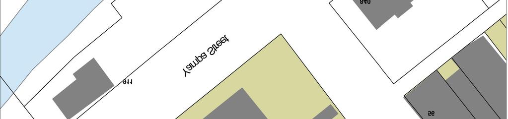
8 Page 8 of 9 Sketch Map


9 911 Lincoln Avenue 5RT.263 Page 9 of 9 Location Map
Architectural Inventory Form
 COLORADO CULTURAL RESOURCE SURVEY Page 1 of 3 Official Eligibility Determination (OAHP use only) Rev. 9/98 OAHP1403 Date Initials Determined Eligible National Register Determined Not Eligible National
Architectural Inventory Form
 OAHP1403 Rev. 9/98 COLORADO CULTURAL RESOURCE SURVEY Architectural Inventory Form Official eligibility determination (OAHP use only) Date Initials Determined Eligible- NR Determined Not Eligible- NR Determined
NE¼ of NE¼ of NE¼ of NE¼ of section Roof configuration (enter one): Gabled Roof / Front Gabled Roof
: Gabled Roof / Front Gabled Roof") OAHP1403 Rev. 9/98 COLORADO CULTURAL RESOURCE SURVEY Official Eligibility Determination (OAHP use only) Date Initials Determined Eligible - National Register Architectural Inventory Form Determined Not
OAHP1403 Rev. 9/98 COLORADO CULTURAL RESOURCE SURVEY Official Eligibility Determination (OAHP use only) Date Initials Determined Eligible - National Register Architectural Inventory Form Determined Not
IMPORTANT NOTICE. Architectural Inventory Form COLORADO CULTURAL RESOURCE SURVEY I. IDENTIFICATION. 305 Eldorado Avenue 5BL.10471
 IMPORTANT NOTICE OAHP1403 Rev. 9/98 COLORADO CULTURAL RESOURCE SURVEY Architectural Inventory Form Page 1 This survey form represents an UNOFFICIAL COPY and is provided for informational purposes only.
MAGIC CITY PARK NE 2 ND AVENUE
 MAGIC CITY PARK 6001 6005 NE 2 ND AVENUE Designation Report City of Miami REPORT OF THE CITY OF MIAMI PRESERVATION OFFICER TO THE HISTORIC AND ENVIRONMENTAL PRESERVATION BOARD ON THE POTENTIAL DESIGNATION
THE BARNACLE 3485 MAIN HIGHWAY
 THE BARNACLE 3485 MAIN HIGHWAY Designation Report City of Miami REPORT OF THE CITY OF MIAMI PLANNING AND ZONING DEPARTMENT TO THE HISTORIC AND ENVIRONMENTAL PRESERVATION BOARD ON THE POTENTIAL DESIGNATION
ADDENDUM. Chain of Title. Block C, Lot 8-9. Adrian I. Velthuis and Floyd T. Grant to Lottie Thompson
 Chain of Title Block C, Lot 8-9 NLP 5175:842 October 18, 1979 NLP 4979:58 October 5, 1977 NLP 4763:448 May 11, 1977 Adrian I. Velthuis and Floyd T. Grant to Lottie Thompson Gentlemens II Properties, Inc.,
FLAGLER WORKER S HOUSE FORT DALLAS PARK S.E. 4 STREET
 FLAGLER WORKER S HOUSE FORT DALLAS PARK 60-64 S.E. 4 STREET Designation Report City of Miami REPORT OF THE CITY OF MIAMI PLANNING DEPARTMENT TO THE HERITAGE CONSERVATION BOARD ON THE POTENTIAL DESIGNATION
 Page 1 Original Update HISTORICAL STRUCTURE FORM FLORIDA MASTER SITE FILE Consult Guide To Historical Structure Forms for detailed instructions Site # 8OR9844 Recorder # 26 Recorder Date 2/20/08 Site Name
HISTORIC SITE FORM HISTORIC SITES INVENTORY
 HISTORIC SITE FORM HISTORIC SITES INVENTORY 1 IDENTIFICATION Name of Property: House at 569 Park Avenue PARK CITY MUNICIPAL CORPORATION (10-08) Address: 569 Park Avenue City, County: Park City, Summit
301 7½ Street SW
 301 7½ Street SW 104-0213-0072 Primary Resource Information: Single Dwelling, Stories 2.00, Style: Other, ca 1890 July 2006: This late-19th-century, 3-bay, 2-story, hip-roofed frame I-house features projecting
STATEMENT OF SIGNIFICANCE
 STATEMENT OF SIGNIFICANCE The National Register of Historic Places identifies three concepts (are historic significance, historic context, and historic integrity) that are used to evaluate whether or not
Gilpin County Historic Preservation Advisory Commission. 114 Redtail Road Historic Eligibility Review
 Gilpin County Historic Preservation Advisory Commission 114 Redtail Road Historic Eligibility Review Deon Wolfenbarger Three Gables Preservation February 18, 2017 BACKGROUND The purpose of the review is
808 Cherry Avenue
 808 Cherry Avenue 104-0213-0059 Primary Resource Information: Single Dwelling, Stories 2.00, Style: Other, ca 1900 July 2006: This 2-story, 3-bay frame I-house features a central-front gable, a brick pier
Current Functions (Enter categories from instructions) Materials (Enter categories from instructions)
 Materials (Enter categories from instructions)") Site Inventory Form State Inventory No. 92-00542 New Supplemental State Historical Society of Iowa Part of a district with known boundaries (enter inventory no.) 92-00349 (November 2005) Relationship:
Site Inventory Form State Inventory No. 92-00542 New Supplemental State Historical Society of Iowa Part of a district with known boundaries (enter inventory no.) 92-00349 (November 2005) Relationship:
Hwy Retaining Wall/ Sea Wall. Not Eligible, see Statement of Significance Also member of listed NR district: Mantorville Historic District
 Historic Name CS # 2007 Other Name SHPO Inv # Location E and W sides of TH 57 between 6th St and 7th St Hwy District Reference City/Township County Mantorville, City of Dodge Acres Twp Rng Sec 107N 16W
Historic Inventory Report
 Location Field Site No. 3394-134 DAHP No. Historic Name: Common Name: Cabinetrends Property Address: 24619 Pacific Hwy S, Kent, WA 98032 Comments: Tax No./Parcel No. 3601800165 Plat/Block/Lot Acreage.24
Town: Sharon Place (neighborhood or village): Sharon. ame of Area: Present Use: Date (month / year): July 2008
: Sharon. ame of Area: Present Use: Date (month / year): July 2008") FORM A - AREA MASSACHUSETTS HISTORICAL COMMISSION MASSACHUSETTS ARCHIVES BUILDING 220 MORRISSEY BOULEVARD BOSTON, MASSACHUSETTS 02125 Photograph Assessor s Sheets USGS Quad Area Letter Form Numbers in
FORM A - AREA MASSACHUSETTS HISTORICAL COMMISSION MASSACHUSETTS ARCHIVES BUILDING 220 MORRISSEY BOULEVARD BOSTON, MASSACHUSETTS 02125 Photograph Assessor s Sheets USGS Quad Area Letter Form Numbers in
HERITAGE PROPERTY RESEARCH AND EVALUATION REPORT
 ATTACHMENT NO. 4 HERITAGE PROPERTY RESEARCH AND EVALUATION REPORT WILLIAM LUKE BUILDINGS 774 YONGE STREET, TORONTO Prepared by: Heritage Preservation Services City Planning Division City of Toronto March
1 Gildersleeve Wood (DHR # )
") GILDERSLEEVE WOOD 1 Gildersleeve Wood (DHR # 104-5092-0012) STREET ADDRESS: 1 Gildersleeve Wood MAP & PARCEL: 11-20 PRESENT ZONING: R-1U ORIGINAL OWNER: Lindsay Family ORIGINAL USE: PRESENT USE: PRESENT
GILDERSLEEVE WOOD 1 Gildersleeve Wood (DHR # 104-5092-0012) STREET ADDRESS: 1 Gildersleeve Wood MAP & PARCEL: 11-20 PRESENT ZONING: R-1U ORIGINAL OWNER: Lindsay Family ORIGINAL USE: PRESENT USE: PRESENT
Maryland Historical Trust Inventory No. PG: 86A-026 Maryland Inventory of Historic Properties Form
 Inventory No. PG: 86A-026 Maryland Inventory of 1. Name of Property (indicate preferred name) historic other 2. Location street and number 12811 Croom Road not for publication city, town Naylor vicinity
Gilpin County Historic Preservation Advisory Commission. 104 Redtail Road Historic Eligibility Review
 Gilpin County Historic Preservation Advisory Commission 104 Redtail Road Historic Eligibility Review Deon Wolfenbarger Three Gables Preservation February 18, 2017 BACKGROUND The purpose of the review is
DESIGNATION REPORT KENNEDY-BAKER-WALKER-SHERRILL HOUSE (1849) 9320 KINGSTON PIKE (CLT ) KNOXVILLE, TENNESSEE July 12, 2007
 9320 KINGSTON PIKE (CLT ) KNOXVILLE, TENNESSEE July 12, 2007") DESIGNATION REPORT KENNEDY-BAKER-WALKER-SHERRILL HOUSE (1849) 9320 KINGSTON PIKE (CLT 132-027) KNOXVILLE, TENNESSEE July 12, 2007 Description The Kennedy-Baker-Walker-Sherrill House is located on the south
DESIGNATION REPORT KENNEDY-BAKER-WALKER-SHERRILL HOUSE (1849) 9320 KINGSTON PIKE (CLT 132-027) KNOXVILLE, TENNESSEE July 12, 2007 Description The Kennedy-Baker-Walker-Sherrill House is located on the south
Appendix E Historic Property Inventory Forms
 Appendix E Historic Property Inventory Forms TECHNICAL MEMORANDUM Sound Transit Federal Way Link Extension WISAARD Survey Entries PREPARED FOR: COPY TO: PREPARED BY: Sound Transit Alisa Swank/ CH2M MaryNell
STATE OF IOWA. Historical and Architectural Survey for 2008 Flood Projects in Vinton, Benton County
 STATE OF IOWA CHESTER J. CULVER GOVERNOR PATTY JUDGE LT. GOVERNOR DEPARTMENT OF PUBLIC DEFENSE IOWA HOMELAND SECURITY AND EMERGENCY MANAGEMENT DIVISION DAVID L. MILLER, ADMINISTRATOR Historical and Architectural
Maryland Historical Trust Inventory No. PG: 75A-007 Maryland Inventory of Historic Properties Form
 Inventory No. PG: 75A-007 Maryland Inventory of 1. Name of Property (indicate preferred name) historic other 2. Location street and number 3101 Ritchie Road not for publication city, town Forestville vicinity
Change dormers and main entry on the river side of the house. Site: 43 Riverbank Road, Block 10 Lot 3
 City of Burlington Historic Preservation Commission Meeting Minutes: December 2, 2015 The City of Burlington Historic Preservation Commission held its regular monthly meeting on Wednesday, December 2,
Address 347 Whitney Street. East elevation, camera facing southwest.
 FORM B BUILDING Assessor s Number USGS Quad Area(s) Form Number MASSACHUSETTS HISTORICAL COMMISSION MASSACHUSETTS ARCHIVES BUILDING 220 MORRISSEY BOULEVARD BOSTON, MASSACHUSETTS 02125 Town Northborough
Village of Skokie Downtown Area Sign Guidelines. for CX Core Mixed Use Zoning District
 Village of Skokie Downtown Area Sign Guidelines for CX Core Mixed Use Zoning District January 2011 (c) 2011 Published by the Village of Skokie, 5127 W. Oakton Street, Skokie, Illinois 60077 Signs are important
Commonwealth of Massachusetts Massachusetts Historical Commission 220 Morrissey Boulevard, Boston, Massachusetts
 Inventory No: Historic Name: Common Name: Address: NWB.3010 Colonial Beacon Oil Company Shed Blue Frontier Yacht Services Office 115 Water St City/Town: Newburyport Village/Neighborhood: Local No: 20-10
RESIDENCE at 8238 NE 9 th Avenue And adjoining lot at 8220 NE9 th Avenue
 RESIDENCE at 8238 NE 9 th Avenue And adjoining lot at 8220 NE9 th Avenue Designation Report December 1, 2009 Historic and Environmental Preservation Board City of Miami NE 83RD ST --.- "1 r_, O~ J ru?
Total 1 Total. Current Functions (Enter categories from instructions) Materials (Enter categories from instructions)
 Materials (Enter categories from instructions)") Site Inventory Form State Inventory No. 29-00962 New Supplemental State Historical Society of Iowa Part of a district with known boundaries (enter inventory no.) 29-03685 (November 2005) Relationship:
Site Inventory Form State Inventory No. 29-00962 New Supplemental State Historical Society of Iowa Part of a district with known boundaries (enter inventory no.) 29-03685 (November 2005) Relationship:
street & number: COUNTY ROUTE 3, HC-88, BOX 17 not for publication: N/A city/town: WHEELER vicinity: X state: WV county: WEBSTER code: 101 zip code:
 NPS Forn 10-900 OMB No. 10024-0018 (Oct. 1990) United States Department of the Interior National Park Service NATIONAL REGISTIR OF HISTORIC PLACES REGISTRATICN FCRX =========================================================---------=======
STATE OF WASHINGTON ARCHAEOLOGICAL SITE INVENTORY FORM
 STATE OF WASHINGTON ARCHAEOLOGICAL SITE INVENTORY FORM Smithsonian Number: 45 County: Chelan Date: 6/12/2018 Human Remains? DAHP Case No.: Archaeological Sites are exempt from public disclosure per RCW
New Orleans Historic District Landmarks Commission Nomination Report 210 State Street, former NOAH Campus July 17, 2014
 New Orleans Historic District Landmarks Commission Nomination Report 210 State Street, former NOAH Campus July 17, 2014 Meeting Date: July 17, 2014 Property Address: Owner: 210 State Street Children s
Commonwealth of Massachusetts Massachusetts Historical Commission 220 Morrissey Boulevard, Boston, Massachusetts
 Inventory No: Historic Name: Common Name: Address: HRV.165 Blood, Joseph House Farnsworth, Jonathan - Beaman, Jonathan House 74 Poor Farm Rd City/Town: Village/Neighborhood: Local No: 9-17 Year Constructed:
Fletchertown (71A-022)
") Fletchertown (71A-022) Fletchertown is a late-nineteenth-century rural African-American community in northeastern Prince George s County. The community is located south of Huntington and northwest of Bowie.
Fletchertown (71A-022) Fletchertown is a late-nineteenth-century rural African-American community in northeastern Prince George s County. The community is located south of Huntington and northwest of Bowie.
CITY OF MURFREESBORO HISTORIC ZONING COMMISSION. Regular Meeting June 19, :30 PM, Council Chambers, City Hall
 CITY OF MURFREESBORO HISTORIC ZONING COMMISSION Regular Meeting June 19, 2018 3:30 PM, Council Chambers, City Hall I. Call to Order and determination of a quorum II. Approve Minutes of the Regular Meeting
NPS Form OMB No Exp Status occupied X unoccupied work in progress Accessible yes: restricted yes: unrestricted _5Lno
 NPS Form 10-900 OMB No. 1024-0018 Exp. 10-31-84 United States Department of the Interior National Park Service National Register of Historic Places Inventory Nomination Form See instructions in How to
Historic Property Report
 Historic Name: Shadle Park Reservoir Property ID: 708465 Location Address: Location Comments: GeographicAreas: 4302 N Belt St, Spokane, Washington, USA Wellesley Ave & N Belt St Spokane,T25R42E01,SPOKANE
HISTORIC DISTRICT STUDY COMMITTEE REPORT GEORGE FARMSTEAD HISTORIC DISTRICT OAKLAND TOWNSHIP, MICHIGAN
 HISTORIC DISTRICT STUDY COMMITTEE REPORT GEORGE FARMSTEAD HISTORIC DISTRICT OAKLAND TOWNSHIP, MICHIGAN HISTORIC DISTRICT STUDY COMMITTEE REPORT GEORGE FARMSTEAD HISTORIC DISTRICT OAKLAND TOWNSHIP, MICHIGAN
ri. Name historic: Oak Cliff United Methodist Church Date 7/17/97 and! or common:
 [ Dallas Landmark Landmark Nomination Commission Form ri. Name historic: Oak Cliff United Methodist Church Date 7/17/97 and! or common: L2. Location addresses: 541-49 E. Jefferson location! neighborhood:
September 13, Presented by: Jeremy Parsons PLANNING & ECONOMIC DEVELOPMENT DEPARTMENT
 Recommendation to Designate Property Located at 828 Sanatorium Road, Hamilton (Mountain Sanatorium Brow Campus) Under Part IV of the Ontario Heritage Act () September 13, 2018 Presented by: Jeremy Parsons
National Register of Historic Places Continuation Sheet
 Section number N/A Page 1 Proposed Amendment to Wichita, Sedgwick County, Kansas The owner of the building at 141 S. Rock Island Avenue requests amendment to the boundaries of the East Douglas Historic
State Level Historic Documentation Report. John Blue Bridge Hampshire County
 State Level Historic Documentation Report State Project No. S314-28-22.27 Federal Project No. BR-0028(058)D John Blue Bridge Hampshire County Prepared by: Randy Epperly, Historian Department of Transportation
United States Department of the Interior National Park Service. Boundary Expansion Listed in National Register January 11, 2017
 NPS Form 10900-a (Rev. 8/2002) OMB No. 10240018 United States Department of the Interior National Park Service Boundary Expansion Listed in National Register January 11, 2017 National Register of Historic
COLORADO HISTORICAL SOCIETY
 SECTION I COLORADO HISTORICAL SOCIETY OAHP1414 (Rev. 11/2001) COLORADO STATE REGISTER OF HISTORIC PROPERTIES NOMINATION FORM Name of Property Historic Name Boor Ranch/Boor Homestead Other Names Redmond
Proposed East Sanford Historic District DRAFT
 Proposed East Sanford Historic District DRAFT Inventory List The following inventory list provides basic information for all properties in the East Sanford Historic District. Included are each property
; * --.-.,., rj ; United States Department of the Interior \ ' '"] I National Park Service
![; * --.-.,., rj ; United States Department of the Interior \ ' '] I National Park Service](/thumbs/88/117765392.jpg "; * --.-.,., rj ; United States Department of the Interior \ ' '] I National Park Service") NPS Form 10-900 OMB No. 1024-0018 (Rev. 10-90) : / i' -_ :. - : ; ; * --.-.,., rj ; United States Department of the Interior \ ' '"] I National Park Service NATIONAL REGISTER OF HISTORIC PLACES REGISTRATION
NPS Form 10-900 OMB No. 1024-0018 (Rev. 10-90) : / i' -_ :. - : ; ; * --.-.,., rj ; United States Department of the Interior \ ' '"] I National Park Service NATIONAL REGISTER OF HISTORIC PLACES REGISTRATION
Maryland Historical Trust Inventory No. PG: Maryland Inventory of Historic Properties Form
 Inventory No. PG: 62-012 Maryland Inventory of 1. Name of Property (indicate preferred name) historic other 2. Location street and number 11205 Old Baltimore Pike not for publication city, town Beltsville
IMPORTANT NOTICE. Architectural Inventory Form COLORADO CULTURAL RESOURCE SURVEY I. IDENTIFICATION Eldorado Avenue 5BL.10486
 IMPORTANT NOTICE OAHP1403 Rev. 9/98 COLORADO CULTURAL RESOURCE SURVEY Architectural Inventory Form Page 1 This survey form represents an UNOFFICIAL COPY and is provided for informational purposes only.
FOREST FIRE LOOKOUT TOWERS OF THE ARAPAHO-ROOSEVELT NATIONAL FORESTS AND ROCKY MOUNTAIN NATIONAL PARK
 This site contains links to other Internet sites. These links are not endorsements of any products or services in such sites, and no information in such site has been endorsed or approved by the USDA Forest
W. Third St. (also ) originally at W. Third St
 originally at W. Third St") Site Inventory Form State Inventory No. 70-00203 New Supplemental State Historical Society of Iowa Part of a district with known boundaries (enter inventory no.) (December 1, 1999) Relationship: Contributing
Site Inventory Form State Inventory No. 70-00203 New Supplemental State Historical Society of Iowa Part of a district with known boundaries (enter inventory no.) (December 1, 1999) Relationship: Contributing
Architectural Inventory Form
 OAHP 1403 Rev. 9/98 COLORADO CULTURAL RESOURCE SURVEY Page 1 of 5 Official Eligibility Determination (OAHP Use Only) Date Initials Determined Eligibile-NR Determined Not Eligible-NR Determined Eligibile-SR
National Register of Historic Places Inventory Nomination Form
 NPS Form 10-900-a Exp. 10-31-84 Continuation sheet 4 5 item number 7 Page 45 NAME: Knight Estate LOCATION: 486 East Avenue,,--v..u^-^ OWNER: State of Rhode Island Department of Education Board of Regents
Photo Album Intact/Slightly Altered. Eligible, see Statement of Significance. Roadside Development on Minnesota Trunk Highways,
 Historic Name CS # 5202 Other Name SHPO Inv # Location Hwy District Reference City/Township County Courtland Township Nicollet Acres 4.6 Twp Rng Sec 110N 30W Sec 22 Rest Area Class 4 USGS Quad UTM New
Site Inventory Form State Inventory No New Supplemental
 Site Inventory Form State Inventory No. 70-00939 New Supplemental State Historical Society of Iowa Part of a district with known boundaries (enter inventory no.) (December 1, 1999) Relationship: Contributing
Introduction...COMB-2 Design Considerations and Examples...COMB-3
 SECTION DIRECTORY General Information Introduction...COMB-2 Design Considerations and Examples...COMB-3 Combination Assembly Recommendations and Limitations Composite Configurations...COMB-4 Typical Sealant
COLORADO HISTORICAL SOCIETY COLORADO STATE REGISTER OF HISTORIC PROPERTIES NOMINATION FORM
 COLORADO HISTORICAL SOCIETY COLORADO STATE REGISTER OF HISTORIC PROPERTIES NOMINATION FORM OAHP1414 (Rev. 8/2003) SECTION I Name of Property Historic Name Other Names HUBBARD RANCH / TEN SLEEP RANCH /
Intention to Designate under Part IV, Section 29 of the Ontario Heritage Act 60 Atlantic Avenue
 STAFF REPORT ACTION REQUIRED Intention to Designate under Part IV, Section 29 of the Ontario Heritage Act 60 Atlantic Avenue Date: December 20, 2012 To: From: Toronto Preservation Board Toronto and East
Maryland Historical Trust Inventory No. PG: 86A-003 Maryland Inventory of Historic Properties Form
 Inventory No. PG: 86A-003 Maryland Inventory of 1. Name of Property (indicate preferred name) historic other 2. Location street and number 12005 Duley Station Road not for publication city, town Upper
National Register of Historic Places Registration Form
 NPS Form 10-900 OMB No. 10024-0018 (Oct. 1990) Registration Form This form is for use in nominating or requesting determinations for individual properties and districts. See instructions in How to Complete
ate: AR County: Pulaski Code: AR Zip Code: Noncontributing buildings sites structures objects Total
 Mims-Ereedlove-Priest-Weatherton House Name of Property Little Rock, AR County and State ~- -,s Form 10-900 'V. 8-86) OMB No. 1024-0018 United States Department of the Interior National Park Service NATIONAL
I Signature of commenting official Date I. / Title State or Federal agencylbureau or Tribal Government 1
 National Park Service National Register of Historic Places Registration Form LISTED ON: VLR 09/20/2012 NRHP 11/20/2012 This form is for use in nominating or requesting determinations for individual properties
Narrative Description (Describe the historic and current condition of the property on one or more continuation sheets.)
") 5. Classification Ownership of Property (Check as many boxes as apply) X private public local public state public Federal Category of Property (Check only one box) X building (s) district site structure
5. Classification Ownership of Property (Check as many boxes as apply) X private public local public state public Federal Category of Property (Check only one box) X building (s) district site structure
Abandoned or Vacant; Agricultural; Camp; Other Residential Agriculture; Archaeology, Historic; Architecture; Politics Government; Social History
 Inventory No: Historic Name: HRV.G Civilian Conservation Camp Common Name: Address: City/Town: Village/Neighborhood: Local No: 13-7.01 Year Constructed: Architect(s): Architectural Style(s): Use(s): Significance:
National Register of Historic Places Registration Form
 National Park Service National Register of Historic Places Registration Form This form is for use in nominating or requesting determinations for individual properties and districts. See instructions in
VILLAGE OF WINNETKA, ILLINOIS DEPARTMENT OF COMMUNITY DEVELOPMENT
 AWN VILLAGE OF WINNETKA, ILLINOIS DEPARTMENT OF COMMUNITY DEVELOPMENT AWNING PERMIT APPLICATION Important note regarding Awning Code changes Effective March 4, 2003, awning regulations were modified to
AH pp. I Ti. Nov 7 I) I I y
 I I y") ..------------------------------------------ ------------ - - -- - NPS Form 10-900 (Rev. 8-86) United States Department of the Interior ~a tional Park Service NATIONAL REGISTER OF HISTORIC PLACES REGISTRATION
..------------------------------------------ ------------ - - -- - NPS Form 10-900 (Rev. 8-86) United States Department of the Interior ~a tional Park Service NATIONAL REGISTER OF HISTORIC PLACES REGISTRATION
Penrith Heritage Inventory
 Address: 1348-1362 Castlereagh Road Suburb / Nearest Town: Castlereagh 2749 Local Govt Area: Penrith State: NSW DUAP Region: Sydney West Historic region: Sydney Parish: County: Cumberland Other/Former
THE FORMER BRADBURY HALL, CHATSWORTH ROAD, CHESTERFIELD. GROUP LEADER, DEVELOPMENT MANAGEMENT
 AGENDA ITEM NO. 7 THE FORMER BRADBURY HALL, CHATSWORTH ROAD, CHESTERFIELD. MEETING: PLANNING COMMITTEE DATE: 17 TH MAY 2004 REPORT BY: WARD: COMMUNITY FORUM: GROUP LEADER, DEVELOPMENT MANAGEMENT HOLMEBROOK
National Register of Historic Places Registration Form
 NPS Form 10-900 OMB No. 10024-0018 (Oct. 1990) United States Department of the Interior National Park Service National Register of Historic Places Registration Form 1. Name of Property historic name Hickory
city or town Muscatine vicinity, county Muscatine Legal Description: (If Rural) Township Name Township No. Range No. Section Quarter of Quarter
 Township Name Township No. Range No. Section Quarter of Quarter") Site Inventory Form State Inventory No. 70-00233 New Supplemental State Historical Society of Iowa Part of a district with known boundaries (enter inventory no.) (December 1, 1999) Relationship: Contributing
Site Inventory Form State Inventory No. 70-00233 New Supplemental State Historical Society of Iowa Part of a district with known boundaries (enter inventory no.) (December 1, 1999) Relationship: Contributing
Agriculture; Architecture; Community Planning
 Inventory No: Historic Name: SBR.Q Bemis - LaurEdo Farm Common Name: Address: City/Town: Village/Neighborhood: Local No: Year Constructed: Architect(s): Architectural Style(s): Use(s): Significance: Agricultural;
United States Department of the Interior National Park Service NATIONAL REGISTER OF HISTORIC PLACES REGISTRATION FORM
 NPS Form 10-900 (Oct. 1990) OMB No. 10024-0018 United States Department of the Interior National Park Service NATIONAL REGISTER OF HISTORIC PLACES REGISTRATION FORM 1. DR JOHN C. IRONS RESIDENCE hlstoric
The meeting house is a converted Plymouth Brethren Chapel which originally was two cottages. It has medium significance.
 Quaker Meeting House, Ashburton Foales Court, off North Street, Ashburton, Devon, TQ13 7QE National Grid Reference: SX 75574 69951 Statement of Significance The meeting house is a converted Plymouth Brethren
National Register of Historic Places Registration Form
 NPS Form 10-900 OMB No. 1024-0018 (Expires 5/31/2012) United States Department of the Interior National Register Listed National Park Service May 1, 2012 National Register of Historic Places Registration
Total 1 Total. Current Functions (Enter categories from instructions) 01D04: hotel 01B02: apartment building
 01D04: hotel 01B02: apartment building") Site Inventory Form State Inventory No. 29-00093 New Supplemental State Historical Society of Iowa Part of a district with known boundaries (enter inventory no.) 29-03685 (November 2005) Relationship:
Site Inventory Form State Inventory No. 29-00093 New Supplemental State Historical Society of Iowa Part of a district with known boundaries (enter inventory no.) 29-03685 (November 2005) Relationship:
National Register of Historic Places Registration Form
 National Park Service National Register of Historic Places Registration Form This form is for use in nominating or requesting determinations for individual properties and districts. See instructions in
THE CORPORATION OF THE TOWN OF NIAGARA-ON-THE-LAKE. BY-LAW NO (214 Four Mile Creek Road)
") THE CORPORATION OF THE TOWN OF NIAGARA-ON-THE-LAKE BY-LAW NO. 4807-15 (214 Four Mile Creek Road) A BY-LAW TO DESIGNATE THE PROPERTY KNOWN MUNICIPALLY AS WOODBOURNE, 214 FOUR MILE CREEK ROAD, IN THE TOWN
THE CORPORATION OF THE TOWN OF NIAGARA-ON-THE-LAKE BY-LAW NO. 4807-15 (214 Four Mile Creek Road) A BY-LAW TO DESIGNATE THE PROPERTY KNOWN MUNICIPALLY AS WOODBOURNE, 214 FOUR MILE CREEK ROAD, IN THE TOWN
county Lonoke code 085 zip code
 ~~~~~~~~~~~ AR NPS Form I 0-900 (Oct. 1990) United States Department of the Interior National Park Service National Register of Historic Places egistration Form w-l.3-1 / OMB No. 10024-0018 This form is
United States Department of the Interior National Park Service NATIONAL REGISTER OF HISTORIC PLACES REGISTRATION FORM. Wilmoth, Bernard E.
 NPS Form 10-900 OMB No. 10024-0018 (Oct. 1990) United States Department of the Interior National Park Service NATIONAL REGISTER OF HISTORIC PLACES REGISTRATION FORM 1. Name of Property historic name: other
D not for publication D vicinity
 NPS Fonn I 0-900 (Oct. 1990) OMB No. 10024-0018 United States Department of the Interior National Park Service National Register of Historic Places Registration Form This fom1 is for use in nominating
WILLIAM TRELOAR HOUSE
 WILLIAM TRELOAR HOUSE This report was written on July 3, 1984 1. Name and location of the property: The property known as the William Treloar House is located at 328 N. Brevard St. in Charlotte, NC. 2.
Section 106 Update Memo #1 Attachment D. Traffic Diversion & APE Expansion Methodology & Maps
 Section 106 Update Memo #1 Attachment D Traffic Diversion & APE Expansion Methodology & Maps I-65/I-70 North Split Interchange Reconstruction Project (Des. Nos. 1592385 & 1600808) Traffic Diversion and
National Register of Historic Places Registration Form
 NPS Form 10-900 OMB No. 10024-0018 (Oct. 1990) United States Department of the Interior National Park Service National Register of Historic Places Registration Form 1. Name of Property historic name other
APPLICATION FORM FOR APPROVAL AS AN IATA PASSENGER SALES AGENT
 APPLICATION FORM FOR APPROVAL AS AN IATA PASSENGER SALES AGENT The information requested below is required by IATA to assist in determining the eligibility of the application for inclusion on the IATA
NPS Form OMB No (Oct. 1990)
") NPS Form 10-900 OMB No. 10024-0018 (Oct. 1990) United States Department of the Interior National Park Service NATIONAL REGISTER OF HISTORIC PLACES REGISTRATION FORM 1. Name of Property historic name:_lost
NPS Form 10-900 OMB No. 10024-0018 (Oct. 1990) United States Department of the Interior National Park Service NATIONAL REGISTER OF HISTORIC PLACES REGISTRATION FORM 1. Name of Property historic name:_lost
Table of Contents. Location... 1 Cultural Heritage Value... 3 Site History... 4 Physical Description... 6 Conclusion... 7 Sources...
 Executive Summary The Outdoor Firing Range, located west of the Small Arms Building at 1300 Lakeshore Road East, merits designation under the Ontario Heritage Act for its historical, architectural and
NATIONAL REGISTER OF HISTORIC PLACES REGISTRATION FORM
 NPS Form 10-900 OMB No. 1024-0018 (Rev. 10-90) United States Department of the Interior National Park Service NATIONAL REGISTER OF HISTORIC PLACES REGISTRATION FORM 1. Name of Property historic name Compton-Johnson
CITY OF ALBERT LEA HERITAGE PRESERVATION COMMISSION
 CITY OF ALBERT LEA HERITAGE PRESERVATION COMMISSION 3/14/2017, 5:30 p.m. City Council Chambers AGENDA A. CALL TO ORDER AND APPROVAL OF THE AGENDA B. APPROVAL OF MINUTES HPC Minutes from February 14 th
MEDIA ADVISORY. FOR IMMEDIATE RELEASE November 12, 2012
 MEDIA ADVISORY FOR IMMEDIATE RELEASE November 12, 2012 Niagara-on-the-Lake On Monday, November 19, 2012, the Lord Mayor and members of the Town s Municipal Heritage Committee and War of 1812 Bicentennial
URBAN DESIGN REPORT. Proposed Residential Development, Old Church Road, Caledon East
 Proposed Residential Development, Old Church Road, Caledon East TABLE CONTENTS: 1.0 DEVELOPMENT 1.1 Introduction-Analysis of Guiding Principles and Documents 1.2 Community Design and Architectural Design
East and north elevations, camera facing west. Condition Good
 FORM B BUILDING MASSACHUSETTS HISTORICAL COMMISSION MASSACHUSETTS ARCHIVES BUILDING 220 MORRISSEY BOULEVARD BOSTON, MASSACHUSETTS 02125 Assessor s Number USGS Quad Area(s) Form Number Town Northborough
AHPP. LISTED ========================================================================
 NPS Form 10-900 (Rev. 8-86) Jnited States Department of the Interior ational Park Service OMB No. 1024-0018 LISTED NATIONAL REGISTER OF HISTORIC PLACES REGISTRATION FORM AHPP. 1. Historic Name: Bush-Dubisson
STREET STATEMENT OF SIGNIFICANCE MARCH 2017
 1195 12 TH STREET STATEMENT OF SIGNIFICANCE MARCH 2017 HISTORIC CONTEXT The Rush House is located in the historic Ambleside neighbourhood of West Vancouver. Due to its position along the Burrard Inlet,
401, and 415 King Street West - Zoning Amendment Application - Preliminary Report
 STAFF REPORT ACTION REQUIRED 401, 407-409 and 415 King Street West - Zoning Amendment Application - Preliminary Report Date: January 27, 2011 To: From: Wards: Reference Number: Toronto and East York Community
MINNESOTA ARCHITECTURE - HISTORY INVENTORY FORM Property Location
 MINNESOTA ARCHITECTURE - HISTORY INVENTORY FORM ------ - Property Location -- ---- Property Name: Washington Park Address: 215 N 4th Street County: Blue Earth City/Twp: Mankato PIN: R01.09.07.461.001 Legal
Iowa Site Inventory Form State Inventory Number: New Supplemental State Historic Preservation Office
 Iowa Site Inventory Form State Inventory Number: 92-00397 New Supplemental State Historic Preservation Office 9-Digit SHPO Review & Compliance (R&C) Number (July 2014) Non-extant Year: Read the Iowa Site
COLORADO HISTORICAL SOCIETY
 SECTION I COLORADO HISTORICAL SOCIETY OAHP1414 (Rev. 11/2001) COLORADO STATE REGISTER OF HISTORIC PROPERTIES NOMINATION FORM Name of Property Historic Name Other Names The Big House Address of Property