COLORADO HISTORICAL SOCIETY COLORADO STATE REGISTER OF HISTORIC PROPERTIES NOMINATION FORM
|
|
|
- Annice Pitts
- 6 years ago
- Views:
Transcription
1 COLORADO HISTORICAL SOCIETY COLORADO STATE REGISTER OF HISTORIC PROPERTIES NOMINATION FORM OAHP1414 (Rev. 8/2003) SECTION I Name of Property Historic Name Other Names HUBBARD RANCH / TEN SLEEP RANCH / JCC RANCH CAMP / 5EL656 Address of Property [ ] address not for publication Street Address COUNTY ROAD City ELBERT County ELBERT Zip Present Owner of Property (for multiple ownership, list the names and addresses of each owner on one or more continuation sheets) Name JEWISH COMMUNITY CENTER OF DENVER Address 350 S. DAHLIA ST. Phone 303/ City DENVER State CO Zip Owner Consent for Nomination (attach signed consent from each owner of property - see attached form) Preparer of Nomination Name RON SLADEK Date 28 MAY 2004 Organization TATANKA HISTORICAL ASSOCIATES, INC. Address 612 S. COLLEGE AVE., SUITE 21, P.O. BOX 1909 Phone 970/ City FORT COLLINS State CO Zip FOR OFFICIAL USE: Site Number 5EL.656 Nomination Received Senate # House # 8/13/2004 Review Board Recommendation 9/8/2004 CHS Board State Register Listing X Approval Denial X Approved Denied Certification of Listing: President, Colorado Historical Society Date
2 COLORADO STATE REGISTER OF HISTORIC PROPERTIES SECTION II Local Historic Designation Has the property received local historic designation? [X] no [ ] yes -- [ ] individually designated [ ] designated as part of a historic district Date designated Designated by (Name of municipality or county) Use of Property Historic Current RANCH / SUMMER CAMP SUMMER CAMP Original Owner RALPH HUBBARD Source of Information A MAN AS BIG AS THE WEST Year of Construction Source of Information A MAN AS BIG AS THE WEST / INTERMOUNTAIN JEWISH NEWS Architect, Builder, Engineer, Artist or Designer RALPH HUBBARD / BILL SUMMERS Source of Information A MAN AS BIG AS THE WEST / INTERVIEW, ELIZABETH SUMMERS Locational Status [X] Original location of structure(s) [ ] Structure(s) moved to current location Date of move SECTION III Description and Alterations (describe the current and original appearance of the property and any alterations on one or more continuation sheets)
3 COLORADO STATE REGISTER OF HISTORIC PROPERTIES SECTION IV Significance of Property Nomination Criteria [X] A - property is associated with events that have made a significant contribution to history [ ] B - property is connected with persons significant in history [ ] C - property has distinctive characteristics of a type, period, method of construction or artisan [ ] D - property is of geographic importance [ ] E - property contains the possibility of important discoveries related to prehistory or history Areas of Significance [ ] Agriculture [ ] Economics [ ] Invention [ ] Architecture [ ] Education [ ] Landscape Architecture [ ] Archaeology - prehistoric [ ] Engineering [ ] Law [ ] Archaeology - historic [X] Entertainment/Recreation [ ] Literature [ ] Art [ ] Ethnic Heritage [ ] Military [ ] Commerce [ ] Exploration/Settlement [ ] Performing Arts [ ] Communications [ ] Geography/Community [ ] Politics/Government [ ] Community Planning Identity [ ] Religion and Development [ ] Health/Medicine [ ] Science [ ] Conservation [ ] Industry [ ] Social History [ ] Transportation Significance Statement (explain the significance of the property on one or more continuation sheets) Bibliography (cite the books, articles, and other sources used in preparing this form on one or more continuation sheets) SECTION V Locational Information Lot(s) N/A Block N/A Addition N/A USGS Topographic Quad Map ELBERT 7.5' (1970, PHOTOREVISED 1979) Verbal Boundary Description of Nominated Property (describe the boundaries of the nominated property on a continuation sheet)
4 COLORADO STATE REGISTER OF HISTORIC PROPERTIES SECTION VI Photograph Log for Black and White Photographs (prepare a photograph log on one or more continuation sheets) SECTION VII ADDITIONAL MATERIALS TO ACCOMPANY NOMINATION Owner Consent Form Black and White Photographs Color Slides Sketch Map(s) Photocopy of USGS Map Section Optional Materials For Office Use Only Property Type: [ ] building(s) [X] district [ ] site [ ] structure [ ] object [ ] area Architectural Style / Engineering Type: Late 19 th / Early 20 th Century American Movements: Rustic Period of Significance: Level of Significance: [X] Local [ ] State [ ] National Acreage: P.M. 6th Township 10S Range 64W Section 15;22 Quarter Sections SW; W SE; NW UTM Reference: Zone Easting Northing Site Elevation: 7000 feet **see continuation page 65 for UTMs
5 COLORADO STATE REGISTER OF HISTORIC PROPERTIES Page 1 Section III Description of the Property The J Bar Double C Ranch is located in the Black Forest, a sprawling, wooded region with an average elevation of 7000' above sea level that projects eastward into the plains to the southeast of Denver and northeast of Colorado Springs. Characterized by rolling hills, gullies, rock outcrops, creeks, and large expanses of pine and spruce broken by broad agricultural valleys and open patches of prairie, the Black Forest today is home to numerous cattle and horse ranches, modern residences, irrigated farms, and small towns situated along the area's creeks. Due to its forest cover, diverse topography and previously affordable land, the Black Forest has also served for decades as the location of a small number of summer camps. Three miles south of the town of Elbert and just west of Kiowa Creek and the Peaceful Valley Boy Scout Ranch is the entrance to a rolling, timbered 388-acre property. The site's perimeter is marked by wire fencing and the entry along the west side of County Road has a cattle grate, now largely buried by soil. However, rather than raising livestock, the J Bar Double C Ranch is a children's summer camp owned and operated since 1952 by the Jewish Community Center of Denver. For the past 52 years, and in fact dating back to the early 1920s, this pristine Western environment has been well suited to summer camp activities such as horseback riding, archery, hiking, swimming, educational pursuits and crafts activities. The unpaved entry road provides the only access to the property's rolling topography, characterized by a combination of forest, rock outcrops, gullies and open prairie. One-half mile into the site the road loops through the approximately 40-acre developed area of the camp. This area contains a collection of camp buildings that includes a central lodge, eleven cabins, two wash houses, director's and caretaker's houses, an office, an infirmary, a dining hall, a recreation hall, and a loafing shed and corral. In addition to these buildings, the developed area holds a swimming pool, two amphitheaters, water wells and tanks, two flood control reservoirs, a secondary corral, an archery range, a basketball court, a grassed sports field, wood platforms for tent camping, and a bonfire area. The remaining timbered and open prairie areas on the site are undeveloped yet contain horseback riding and hiking trails, fence lines, and a ropes course. Open areas of ground, particularly to the northeast of the developed camp area and along the upper west property line, exhibit furrows and low snaking mounds that are actually landscaped flood control features dating from the middle decades of the 1900s. Connecting the camp buildings and other developed features to one another are numerous unpaved driveways and walking paths. In areas subject to erosion, some of the walking paths include railroad tie steps. Plantings intentionally placed on the site are found in two primary locations: the yard around the central lodge and the area between the northern cabins and the sports field. The yard areas to the north and east of the lodge, one of the site's oldest buildings, contain flower beds as well as trees and shrubs that exhibit evidence of their planned placement there early in the 20th century. Just north of the northern collection of cabins and south of the sports field are two long rows of mature conifer trees, stretching for several hundred yards, that were planted in the early 1960s to act as a wind break and reduce soil erosion. Surrounding the J Bar Double C Ranch are largely undeveloped or minimally developed ranch and summer camp properties in all directions. While the areas to the south and west consist of forest
6 COLORADO STATE REGISTER OF HISTORIC PROPERTIES Page 2 Section III and open ranch land, the areas to the north and east are occupied by the expansive Pleasant Valley Boy Scout Camp, which was developed during the 1960s. All of these surrounding properties are composed largely of forest, broken by patches of open prairie along with agricultural fields along Kiowa Creek. In essence, the character of the J Bar Double C Ranch's surroundings has been maintained in its rural form, appearing much as it did during the period of significance and during the earlier period of its original settlement in the late 1800s. In general, the camp site is in good condition with virtually all of its developed features from the period between 1952 and 1967 intact and either little changed or unchanged. Because of this, the property as a whole exhibits a high degree of historic integrity, clearly conveying its history and significance to the modern visitor.


7 COLORADO STATE REGISTER OF HISTORIC PROPERTIES Page 3 Section III Site Location Map Showing Acquisition Dates and Nominated Boundaries
8 COLORADO STATE REGISTER OF HISTORIC PROPERTIES Page 4 Section III Plan of Developed Features
9 COLORADO STATE REGISTER OF HISTORIC PROPERTIES Page 5 Section III Description of the Lodge The two story, cruciform-shaped Lodge, with overall dimensions of 62' x 80', is the most complex building on the site, both in terms of its history and architecture. The first building at the camp to be reached when entering the property along the main road, the Lodge was built in 1921 by Ralph Hubbard and dominates the site as its most important and central historic feature. During its early decades, the building contained a living room, kitchen, storage rooms, library and dining room, along with five bedrooms on the second floor. Today the main floor contains a living room, kitchen, pool table room, dark room, computer room and bedroom, along with six bedrooms upstairs. While serving as a ranch house and camp lodge in earlier years, over the past six decades the Lodge has been used by the J Bar Double C Ranch as a place of gathering and recreation, along with providing sleeping rooms for guests and staff members. After 83 years of use, the building today exhibits a high degree of historic integrity dating from the period of its construction in Constructed of unhewn logs with saddle notching at the corners, the north facing, one story projection containing the main entry rests upon a raised river cobble foundation. This area of the Lodge is connected at the rear (south) end to the larger two-story remainder of the building. Erected with logs on the main floor and wood framing on the second, the entire two-story area of the building rests on a concrete foundation and includes a basement beneath the eastern projection. Because of the two different foundation materials noted, as well as varying methods of construction, it appears that the building was constructed in two phases. The first of these was likely the north projection, which may date from an earlier period. However, documentary evidence clearly states that the building was constructed, or at least greatly expanded, in 1921 to reach its current configuration. Access to the basement is gained through a small wood framed, gabled shed that projects from the south side of the eastern projection to cover a concrete stairway. With its concrete walls and dirt floor, the basement has provided storage space for the Lodge. The ground floor walls on the entire building are constructed of unhewn logs, exhibiting a combination of saddle, square, and V- notching. Between the logs is concrete chinking. A shed-roofed storage room projecting from the north side of the building off the western projection's kitchen is constructed of random fieldstone. Square-butt wood shingles cover the exterior wood-framed walls on the second floor. The asphaltshingled roof consists of intersecting gables with exposed rafter ends and purlins. Five stone chimneys were constructed on the building in 1921, three large ones for heat and the other two to serve as kitchen flues. The fireplace chimneys are found on the north end wall of the north projection, the north end wall of the east projection, and the west side wall of the south projection. The fireplace chimney on the north projection is constructed on the exterior with random river cobble stones and finished on the interior with petrified wood. The other two fireplace chimneys are constructed of random fieldstone on the exterior and petrified wood and quartz on the interior. These materials are found in abundance throughout the property, with the river cobble most likely collected from along Kiowa Creek to the east. All of the fireplace chimneys pierce the roof line. The following porches are found on the building, all located at the ends of each of the four projections:
10 COLORADO STATE REGISTER OF HISTORIC PROPERTIES Page 6 Section III The north porch is accessed by way of five concrete steps that rise from the front walk to the concrete porch floor, which rests upon a river cobble foundation. The lowest of these steps contains the words "Hubbard Ranch" inset in darker concrete. The projecting open porch is constructed of log posts and joists, an open log rail, and a wood plank ceiling with exposed rafters. The wall of the building is dominated by the river cobble fireplace chimney along with the main entry. The entry consists of an old wood screen door and wood panel door with four fixed lights and historic metal hardware. The east porch, resting upon a log pier foundation, is accessed by way of two concrete steps that rise from the concrete sidewalk to the wood plank porch floor. Constructed of log posts and wood joists, the projecting open porch includes a closed log rail with square notching. The main wall of the building is constructed of horizontal logs and contains the east entry, which consists of an old wood screen door and a wood panel door with early metal hardware and a single light that has been boarded closed. Sometime around the 1970s, the porch structure was reinforced with minimal wood framing that left the original features intact. On the second floor, directly above the ground floor porch, is a closed porch that provides access to the upstairs bedrooms. This early structure is accessed by way of a long wood stairway that rises from the ground to the south, terminating at a small balcony. The stairway and balcony are surrounded by an open rail with squared wood balusters. At the north end of the balcony, a vertical plank door enters the closed second floor porch, which serves as an entry and sitting room for the adjacent bedrooms. This wood frame, gabled structure is finished on the exterior with wood shingles and contains old wood sliding windows with six lights in each. The narrow south porch, resting upon an open concrete slab, is one step above the surrounding unpaved grounds. Supported by four log posts, the two-story open porch projects from the building and is covered by a hipped roof with asphalt shingles. The upper level of the porch is accessed by way of a wood stair that rises from the unpaved ground to the west. This stair and the upper level porch are finished with an open wood rail with squared balusters. The lower level has no rail. The main floor bedroom is entered through a wood screen and a hollow core door. On the second floor, the bedroom is entered through a wood screen and a wood panel door with a single boarded light. The main building wall at this location is log on the ground floor and finished with wood shingles on the upper level. Each floor contains one window adjacent to the doorway. The narrow west porch, resting upon an open concrete slab, is one step above the surrounding unpaved grounds. Supported by four log posts, the two-story open porch projects from the building and is covered by a hipped roof with asphalt shingles. The upper level of the porch is accessed by way of a wood stair that rises from the unpaved ground to the south. This stair and the upper level of the porch are finished with an open wood rail with squared balusters. The lower level has no rail. The ground floor of the porch contains no entry to the building, with the main wall at this location limited to horizontal logs and two small windows. The second floor of the porch has an entry to the bedrooms that consists of a wood screen and a vertical wood plank door. In addition to the porch entries, the Lodge can also be accessed through a south-facing door on the west projection that first enters a small store room and then the kitchen. This entry contains an old screen and a hollow-core split door. Because of its location facing into the adjacent
11 COLORADO STATE REGISTER OF HISTORIC PROPERTIES Page 7 Section III courtyard, this entry is the one most often used by the camp to access the public rooms on the main floor of the Lodge. Windows on the Lodge primarily consist of a combination of old wood sliding windows and casements with 1, 2, 4 or 6 lights in each. Almost all are set in wood frames and surrounds, and most appear to be original to the building. The interior area of the Lodge with the greatest historic integrity is the north projecting living room. This space exhibits the early fireplace (finished with petrified wood, a wood mantle, and a river cobble hearth), exposed log walls with chinking, exposed log trusswork, historic wood sliding windows, deep braced window sills (possibly designed to serve as shelves), and the old front panel door with original hardware. The east projection, now used as a pool table room and dark room, retains its wood flooring, wood trim, plaster walls, and petrified wood fireplace with concrete mantle and hearth. The west kitchen projection exhibits early wood flooring, log posts, flues and stone chimneys for the original cooking stoves, plaster walls and ceilings, and an old panel door into the north-projecting stone store room. The south projection features its stone fireplace, log posts and wood paneling. On the second floor, the bedrooms have retained their plaster walls and angled ceilings, old wood doors, wood flooring, and historic windows and stone chimneys. Alterations to the exterior of the Lodge since 1921 have been limited to the circa 1970s replacement of a very small number of windows and doors (with the early wood surrounds retained), the circa 1970s reconstruction of the early second floor stairs and rails (these replaced pre-existing stairs and rails at these locations), and the recent installation of a new asphalt-shingled roof and gutters. None of these changes seriously diminished the historic integrity of the 1921 building, which is otherwise intact. The grounds surrounding the Lodge exhibit a number of features that date from 1921 or the immediately following years when the property operated as the Hubbard Ranch. A deep water cistern, no longer in use, is found outside the northwest walls of the building adjacent to the stone storage shed. Curved stone pathways cross the northeast and northwest lawns, and a deteriorating concrete walkway extends to the northeast from the east porch. Evidence of a historic walkway heading due east across the yard from the east entrance to the building can also be seen. Smaller stones line flower gardens found to the east and north of the Lodge. Marking the perimeter of the Lodge grounds on the north, northeast, east and southeast is a low stone wall topped by a woven wire fence. On the southeast, the wall travels as far south as the north wall of Cabin 1. The northern length of the fieldstone wall includes five tall stone piers, four of which flank two original gated entries to the Lodge grounds. The main entry gateway, directly north of the building's northern projection, is paved with stone stairs. A concrete step is found at the second entry gateway to the east. These entries formerly held wrought iron gates that are missing today except for their hinges and latches. Plantings in the yard areas surrounding the building include a variety of shrubs as well as mature pines, junipers, and cottonwoods that date from the 1920s.
12 COLORADO STATE REGISTER OF HISTORIC PROPERTIES Page 8 Section III Lodge Diagram
13 COLORADO STATE REGISTER OF HISTORIC PROPERTIES Page 9 Section III Description of Cabin 1 Cabin 1, a one story, wood frame building, is located across the courtyard to the southeast of the Lodge. Facing toward the west, the rectangular (19' x 28') building is located on a steep slope and rests on a combination stone and concrete foundation. The original log building at this location, dating from 1921 if not earlier, measured 13' x 28' and rested upon a stone foundation. It is believed to have been used during its earlier years as a bunkhouse. This was torn down in 1953 and the current building erected that year by camp caretaker Bill Summers over the existing stone and expanded concrete foundation for use as the J Bar Double C Ranch's infirmary. Following construction of the camp's current infirmary in 1959, the building was redesignated Cabin 1 and placed into use as campers' lodgings. Cabin 1 retains a high degree of historic integrity dating from its construction in The exterior of Cabin 1 is finished with vertical knotty pine log siding, installed over rolled tar paper and wood sheeting. The roof is side-gabled with exposed rafter ends and asphalt shingles. One entrance, facing onto the courtyard, is located on the west wall near the northwest corner. This entry contains an old wood screen and an old wood cross-and-bible panel door. Next to the door, on a small wood plaque, is the cabin number in Hebrew (the letter aleph). Evidence of an early second doorway can be seen on the west wall south of the current entry, however this was evidently closed in 1959 with the same vertical log siding found on the rest of the building. The windows are predominantly a combination of 1/1 double hung sashes and wood casements with wood sills and knotty pine log siding surrounds. Inside Cabin 1, the building's only visible historic feature is the old wood flooring that remains in place. Outside, a two-foot-high fieldstone wall travels from the north foundation of Cabin 1 for about 10' to the north, where it terminates at an old vertical log gate post. Alterations to the exterior of this building since it was constructed are limited to the replacement of a couple of rear windows in recent decades, closure of the second entrance in 1959, and the installation of a new roof in recent years. None of these changes seriously diminished the historic integrity of the 1953 building, which is otherwise intact.
14 COLORADO STATE REGISTER OF HISTORIC PROPERTIES Page 10 Section III Cabin 1 Diagram
15 COLORADO STATE REGISTER OF HISTORIC PROPERTIES Page 11 Section III Description of Cabin 2 Cabin 2, a narrow one story log building measuring 11' x 54', is located across the courtyard to the south of the Lodge. Facing toward the north, the building is located on a slope and rests on a stone foundation. The northern one-third of this building predates the remainder of the cabin, if even for a short time. Physical evidence is found on the building to indicate that it was constructed in two phases. Originally measuring 11' x 22', the building was expanded to the south by two-thirds and appears to have been completed in 1921 by Ralph Hubbard for use as a bunkhouse. Since 1953, it has been in continuous use by the J Bar Double C Ranch as campers' lodgings. Cabin 2 retains a high degree of historic integrity dating from its completion in The cabin is constructed with unhewn log walls exhibiting a combination of square and V-notching and the roof is gabled with exposed log purlins, fascia boards, and asphalt shingles. Facing north onto the courtyard, the main entrance is located on the front porch. This projecting, open, groundlevel porch is characterized by its concrete floor, closed log rail, three log posts, ceiling of log beams and wood planks, and hewn beams in the front gable. Covering the porch is the building's projecting main gabled roof. The short north entry contains an old vertical wood plank door with early wood frame and hardware. At the rear of the building is a secondary entrance, reached by way of two deteriorating old concrete steps. This entry contains a modern wood door. Windows in Cabin 2 primarily consist of very old two- and four-light wood casements with plain wood sills and surrounds. Also found on the building are one old fixed six-light window with flanking four-light casements, one modern aluminum fixed window with flanking sliding windows framed in an older window space, one small old fixed window, and two early window spaces on the rear elevation that have been boarded shut. Inside Cabin 2, the building retains visible historic features, including an old three-level concrete floor (stepping down toward the south), exposed log roof beams, a wood plank ceiling, and window framing. Alterations to this building since 1921 are limited to the installation of asphalt shingles on the roof and the replacement or closure of a small number of windows near the rear of the structure. None of these changes seriously diminished the historic integrity of the building, which is otherwise intact.
16 COLORADO STATE REGISTER OF HISTORIC PROPERTIES Page 12 Section III Cabin 2 Diagram
17 COLORADO STATE REGISTER OF HISTORIC PROPERTIES Page 13 Section III Description of Cabins 3-5 Cabins 3-5, located in a single three-part, one story wood frame building measuring 23' x 75', are situated across the courtyard to the west of the Lodge. Facing toward the east, the building rests on a concrete foundation and each segment steps down one level toward the north. The building originally consisted of two bunkhouses, probably dating from the 1920s and built by Ralph Hubbard, that were reportedly located on the rise above the camp to the west near where the water storage tank is now found. These were moved down to the main camp area circa 1954 by Bill Summers and connected in the middle at that time with the construction or addition of a third, central segment. Since that time, these three connected buildings have been in continuous use as campers' lodgings, with each individual cabin measuring 23' x 25'. Cabins 3-5 retain a high degree of historic integrity dating from their period of connection around On the exterior, Cabins 3-5 are finished with vertical knotty pine log siding, installed over rolled tar paper and wood sheeting. The roof is side-gabled with exposed rafter ends and asphalt shingles. The single entrances to each of the three cabins face east onto the courtyard, and are located along the length of the east projecting porch. Each entry contains an old wood screen and an old wood panel door with four lights. The windows are predominantly 1/1 double hung sashes with wood sills and knotty pine log siding surrounds. Three of the windows on the rear (west) of the building have been replaced in recent years with 1/1 double hung aluminum windows. The stepped projecting open front porch, which runs the entire length of the east elevation, has a concrete floor, no rail, ten log posts, and a shed roof with exposed rafter ends. This porch was clearly added in the 1950s soon after the buildings were connected. Next to each entry door on the porch is the cabin number, hand-painted in both English and Hebrew. Inside the cabins, the only visible historic feature is the old wood flooring, installed on a diagonal, that remains in place. Alterations to Cabins 3-5 since they were connected around 1954 are limited to the early addition of the open porch, along with recent installation of new asphalt shingles on the roof and the replacement of three rear windows in the past decade. None of these changes seriously diminished the historic integrity of the circa 1954 building, which is otherwise intact.
18 COLORADO STATE REGISTER OF HISTORIC PROPERTIES Page 14 Section III Cabins 3-5 Diagram
19 COLORADO STATE REGISTER OF HISTORIC PROPERTIES Page 15 Section III Description of the South Wash House The South Wash House, a one story, wood frame building, is located across the courtyard to the southwest of the Lodge. Facing toward the north, the rectangular (24' x 45') building is located on a slope and rests on a concrete foundation. The original log building at this location, dating from the early 1920s and historically used as a wash house, was torn down in 1953 and replaced that year by Bill Summers with the building currently found there. Between 1953 and about 1957, it served as the J Bar Double C Ranch's sole wash house. Containing boys and girls lavatories, a boiler room, and a laundry, the interior of the building was upgraded around 1961 by Naval Reserve Engineers. With few changes since that time, the South Wash House retains a high degree of historic integrity dating from its construction in The exterior of the South Wash House is finished with vertical knotty pine log siding, installed over rolled tar paper and wood sheeting. The roof is side-gabled with wide boxed eaves and asphalt shingles. Two main entrances, one each for boys and girls, face north onto the courtyard with a concrete sidewalk running between these doorways. Additional secondary entrances are found on the east and south elevations, both accessed by way of wood stoops. Wood screens and modern hollow-core doors are present in all the entries. A drinking fountain projects from the north wall just east of the girls lavatory entrance. The windows on the building are predominantly 1/1 double hung sashes with wood frames, knotty pine log siding surrounds, and frosted glass. Inside the South Wash House, the building's only visible historic features are the concrete floors and wood stalls that appear to date from the 1961 remodel of the interior. Alterations to this building since it was constructed are limited to the possible installation of new wood doors sometime around the 1960s or 1970s and the interior upgrades dating from the early 1960s. None of these changes seriously diminished the historic integrity of the building, which is otherwise intact.
20 COLORADO STATE REGISTER OF HISTORIC PROPERTIES Page 16 Section III South Wash House Diagram
21 COLORADO STATE REGISTER OF HISTORIC PROPERTIES Page 17 Section III Description of the Director's House The Director's House, a one story, wood frame building, is located to the southwest of Cabins 3-5 and west of the South Wash House. Facing toward the north, the rectangular (24' x 28') building rests on a concrete foundation. Prior to the construction of this building around 1959 by Bill Summers, the camp director resided either in a trailer home or in the Lodge. The exterior of the Director's House is finished with vertical knotty pine log siding, installed over rolled tar paper and wood sheeting. The roof is gabled with exposed rafter ends, exposed purlins with fascia boards, and asphalt shingles. The main entrance, facing north, is accessed by way of a concrete stoop that rises three steps to the doorway. Above the stoop is a projecting gabled hood with wood braces, knotty pine logs on the gable front, and asphalt shingles. A secondary entrance is found on the east elevation, accessed by way of a roughly-poured concrete stoop with three steps. The main entry contains an old wood panel door with four lights and historic hardware, and the side entry contains an old wood screen and an old wood panel door with one light. The windows on the building are all modern 1/1 double hung metal sashes with knotty pine log siding surrounds. While these replaced the building's original 1/1 double hung sashes, they allowed it to retain its overall original appearance. Inside the Director's House, the building's only visible historic features are its old panel doors and hardware that appear to date from the 1950s if not earlier. These may have been scavenged from an earlier building. The front yard, bordered by a split rail fence, contains eighteen preformed concrete steps that connect the front entry stoop with the driveway to the north and provide direct access between the director's house and the adjacent camp office. Alterations to this building since it was constructed are limited to the installation of new windows and a new roof in the past decade. The 1/1 double hung sash appearance of these windows has left the building looking as it did originally. None of these changes seriously diminished the historic integrity of the circa 1959 building, which is otherwise intact.
22 COLORADO STATE REGISTER OF HISTORIC PROPERTIES Page 18 Section III Director's House Diagram
23 COLORADO STATE REGISTER OF HISTORIC PROPERTIES Page 19 Section III Description of the Camp Office The Camp Office, a small one story, rectangular (14' x 25') wood frame building, is located to the north of the Director's Cabin and west of Cabins 3-5. Facing toward the west, the structure rests on a raised concrete foundation (40" in height) that is older than the building itself. A small bunkhouse or shed is believed to have been located on this foundation, most likely dating from the 1920s. However, this was removed circa 1955 and replaced at that time by Bill Summers with the office now found there. Prior to the construction of this building, the camp staff utilized the Lodge for its office functions. The exterior of the Camp Office is finished with weatherboard siding and the newer metal roof is side-gabled with exposed rafter ends and fascia boards. A single entrance, facing west, is accessed by way of a concrete stoop that rises one step to the doorway. In the entry are a wood screen door and a hollow core wood door. Pairs of sliding metal windows with wood surrounds are found on the building, except for one window space on the west elevation that contains a pair of swinging wood shutters. Flower boxes hang from the sills of the front windows and a camp mailbox is mounted adjacent to the main entry door. Loudspeakers for announcements are mounted on the southwest and northwest corners of the building. Inside the Camp Office, the building's only visible historic features are an old wood panel door and 9" x 9" floor tiling, both of which appear to date from the 1950s. The only alteration to the building since it was constructed has been the installation of a modern raised seam metal roof, leaving the building's historic integrity intact.
24 COLORADO STATE REGISTER OF HISTORIC PROPERTIES Page 20 Section III Camp Office Diagram
25 COLORADO STATE REGISTER OF HISTORIC PROPERTIES Page 21 Section III Description of Cabin 6 Cabin 6, a one story, rectangular (20' x 60') wood frame building, is located to the northeast of Cabins 7-8 and southeast of the Dining Hall. Constructed in 1967 by Bill Summers, this building was the last one erected to fill out the J Bar Double C Ranch camp facilities. It has been used since that time for two purposes: the southern half of the building contains a campers' cabin and the northern half contains two storage and activity rooms for arts and crafts and other camp programs. Facing toward the southeast, the structure rests on a concrete foundation and is finished on the exterior with vertical knotty pine log siding installed over rolled tar paper and wood sheeting. The roof is side-gabled with exposed rafter ends and asphalt shingles. Three entrances are found on the east elevation, all accessed by way of two wood stoops that rise several steps from the unpaved grounds and have open wood rails. The southern two of these entries contain old wood panel doors, one with an old wood screen. The entry to the north contains an old vertical wood plank door with four lights and old hardware. Another entrance, found on the south elevation, is accessed by way of a concrete stoop that contains the following inscription: "B.S. [Bill Summers] Mar. 24, 1967." The entry at this location contains an old wood panel door with old hardware. The windows on the building are all old 1/1 double hung wood sashes with knotty pine log siding surrounds. Inside Cabin 6, the building's only visible historic features are its old wood floors. The only alteration to the building since it was constructed has been the installation of modern asphalt shingles on the roof, leaving the building's historic integrity intact.
26 COLORADO STATE REGISTER OF HISTORIC PROPERTIES Page 22 Section III Cabin 6 Diagram
27 COLORADO STATE REGISTER OF HISTORIC PROPERTIES Page 23 Section III Description of Cabins 7-8 Cabin 7-8, an L-shaped one story log building with wings of equal length (each is 29' long), is located to the northwest of the Camp Office and southwest of Cabin 6. The building was originally constructed in 1921 by Ralph Hubbard for use as a bunkhouse. Since 1953, it has been in continuous use by the J Bar Double C Ranch as campers' lodgings. Although it has a new roof, the building has otherwise changed little from its original construction and retains a high degree of historic integrity dating from its completion in Located on a slope, this building rests on a stone foundation that rises from 4" to 24" above the ground. Cabin 7-8 is constructed with unhewn log walls with saddle notching at the corners and the roof consists of two intersecting gables with exposed rafter ends, exposed log purlins, and metal sheeting. Facing to the southwest and southeast, the wing ends of the building contain porches and the two main entrances. The southeast projecting open porch is characterized by its raised concrete floor with one concrete step on the south, open log rail, five log posts with stubbed branches, and log beams. The southwest projecting open porch is characterized by its ground-level dirt floor, open log rail and log beams. Covering both of the porches are the building's projecting main gabled roofs. The southeast entry contains an old wood screen door and an old wood board and batten door. The southwest entry contains an old wood panel door and hardware that appear to date from the late 1800s. Windows in Cabin 7-8 are almost all old four-light wood casements with plain wood sills and surrounds. The only exception is one old single-light wood casement. Inside Cabin 7-8, the building exhibits no historic features of any kind. However, it is possible that some have been retained behind the current flooring and wall boards. Alterations to this building since 1921 have been limited to the interior, except for the installation of a modern raised seam metal roof in the past decade. None of these changes seriously diminished the historic integrity of the building, which is otherwise intact.
28 COLORADO STATE REGISTER OF HISTORIC PROPERTIES Page 24 Section III Cabin 7-8 Diagram
29 COLORADO STATE REGISTER OF HISTORIC PROPERTIES Page 25 Section III Description of Cabins 9 & 10 Cabins 9 and 10, almost identical rectangular (21' x 34') one story wood frame buildings, are located adjacent to one another in the northwest corner of the developed camp area to the northwest of the North Wash House. They were erected for the J Bar Double C Ranch circa 1963 by Naval Reserve Construction Battalions (Seabees) who were engaged at the time constructing the Peaceful Valley Boy Scout Ranch across the county road to the east. Since 1963, these two buildings have been in continuous use as campers' lodgings. With few changes since that time, the buildings have retained a high degree of historic integrity dating from the period of their completion. The east-facing buildings rest on concrete foundations and are constructed with wood framing finished on the exterior with curved horizontal wood siding boards that give them an appearance reminiscent of log construction. The broad gabled asphalt-shingled roof is supported by heavy wood beams that project from the front wall to form exposed purlins. On the southeast corners of each building are cutaway open porches simply defined by their concrete floors, square posts, and open wood rails. These are accessed on Cabin 9 by two wood steps and on Cabin 10 by two concrete steps rising from the surrounding unpaved grounds. Entering each of the buildings from these porches are two wood doors with no lights, one facing north and the other to the west. The doors on the north walls go into small storage rooms and the ones on the west provide access to the living quarters for the camp counselors assigned to these cabins. The main entry on each building, providing direct access to the campers' bunks, is located near the center of the east elevation and contains one hollow core wood door. Windows in Cabins 9 and 10 are almost all wood 1/1 double hung sashes, except for the large picture window on each porch. The picture window on Cabin 9 contains one large fixed light and the one on Cabin 10 is separated into nine fixed lights. Cabin 10 also has one fixed light set into the east gable wall near the northeast corner of the building. The same window space in Cabin 9 is boarded closed with plywood. All of the doors and windows have plain wood surrounds. Inside Cabins 9 and 10, the buildings exhibit no significant historic features other than wood floors. Alterations to these buildings since 1963 have been limited to the probable replacement of an original nine-light front picture window on the porch of Cabin 9 with the single light window found there today along with the boarding shut of the gable window on this cabin. None of these changes seriously diminished the historic integrity of the buildings, which are otherwise intact.
30 COLORADO STATE REGISTER OF HISTORIC PROPERTIES Page 26 Section III Cabins 9 & 10 Diagram
31 COLORADO STATE REGISTER OF HISTORIC PROPERTIES Page 27 Section III Description of Cabins 11, 12 & 14 Cabins 11, 12 and 14, virtually identical rectangular (18' x 32') one story wood frame buildings, are located adjacent to one another on the northern edge of the developed camp area to the northeast of the North Wash House and southwest of the swimming pool. All were erected by the J Bar Double C Ranch in the winter and spring of 1953 as the camp was being prepared for its opening season. Since that year, these buildings have been in continuous use as campers' lodgings. With few changes since that time, they have retained a high degree of historic integrity dating from the period of their construction. The cabins rest on small concrete piers that raise them four to twelve inches above the ground and are constructed of wood framing finished on the exterior with horizontal wood tongue-in-groove weatherboard siding. Their asphalt-shingled gabled roofs are otherwise characterized only by exposed rafter ends and fascia boards. On the northwest (Cabin 14) and southwest (Cabins 11 & 12) corners of the buildings are cutaway open porches simply defined by their wood floors and open wood rails with five squared wood posts. These are accessed by wood steps rising from the surrounding unpaved grounds. Entering each of the buildings from these porches are two wood doors with no lights. The doors toward the ends of the buildings enter what have been used as the living quarters for the camp counselors assigned to these cabins, with the other doors providing direct access to the campers' bunks. Windows in Cabins 11, 12 and 14 are mostly original 6-light wood single-hung sashes that can be raised upward into the wall framing above. A small number of these have been replaced with modern 1/1 double-hung windows. All of the doors and windows have plain wood surrounds. Inside Cabins 11, 12 and 14, the buildings exhibit no significant historic features other than wood floors. Cabin 11 has a bronze plaque mounted on the south wall next to the porch that reads: "Donated by the J.W.V. [Jewish War Veterans] Post 342, Denver, Colo." The plaque on the front of Cabin 14 is gone, although it can be seen where it was mounted. Alterations to these buildings since 1953 have been limited to the replacement of a very small number of the original windows with modern double-hung windows and the installation of new asphalt shingles on the roofs. None of these changes seriously diminished the historic integrity of the buildings, which are otherwise intact.
32 COLORADO STATE REGISTER OF HISTORIC PROPERTIES Page 28 Section III Description of Cabin 13 Cabin 13 is a rectangular (18' x 36') one story wood frame building located on the northern edge of the developed camp area to the east of Cabin 12 and north of Cabin 14. Cabin 13 was erected by Bill Summers around 1958 as the number of camp attendees continued to rise. Since that time, the building has been in continuous use as campers' lodgings. With few changes, it has retained a high degree of historic integrity dating from the period of its construction. The building rests on small concrete piers and is constructed of wood framing finished on the exterior with curved horizontal wood siding boards that give it an appearance reminiscent of log construction. The asphalt-shingled gabled roof is otherwise characterized only by its exposed rafter ends. On the southwest corner of the building is a cutaway open porch simply defined by a wood floor and open wood rail with five squared wood posts. In general, it appears that the design for Cabin 13 was taken from the almost identical patterns for Cabins 11, 12 and 14 although the use of a different siding material on Cabin 13 gives it a somewhat different exterior appearance. Entering the building from the porch are two wood doors with no lights. The door toward the end of the building enters what has been used as the living quarters for the camp counselor assigned to this cabin, with the other door providing direct access to the campers' bunks. Windows in Cabin 13 are original wood 1/1 double-hung sashes. All of the doors and windows have plain wood surrounds. Inside Cabin 13, the building exhibits no significant historic features other than the wood floor. Alterations to the building since 1958 have been limited to the installation of new asphalt shingles on the roof in recent years. None of these changes seriously diminished the historic integrity of the building, which is otherwise intact.
33 COLORADO STATE REGISTER OF HISTORIC PROPERTIES Page 29 Section III Cabins 11, 12, 13 & 14 Diagram
34 COLORADO STATE REGISTER OF HISTORIC PROPERTIES Page 30 Section III Description of the North Wash House The North Wash House is a rectangular (18' x 41') one story wood frame building located among the northern complex of buildings in the developed camp area to the southeast of Cabin 9 and southwest of Cabin 11. Erected by Bill Summers around 1958, possibly in two phases, the building has served since that time as the shower and restroom facility for the northern cluster of cabins. With few changes, it has retained a high degree of historic integrity dating from the period of its construction. The building rests on a concrete pad and is constructed of wood framing finished on the exterior with curved horizontal wood siding boards that give the building an appearance reminiscent of log construction. The asphalt-shingled gabled roof is otherwise characterized only by its exposed rafter ends. Extending to the north from the north elevation of the building is an 11' x 15' shed-roofed carport supported by square wood posts. An old screen door and a wood hollow core door fill the main entry on the east elevation. In front of this entry is a concrete pad that extends a few feet to the south, where a drinking fountain is found. Two secondary entrances are located on the south elevation. One of these contains a wood panel door with a single light (now boarded closed) that provides access to a boiler room. The other doorway is currently boarded closed. A short concrete pad extends along the ground between these two entries. Windows on the North Wash House are mostly original wood two-light hoppers with simple wood surrounds, all of them located high on the walls just beneath the eaves. Inside the North Wash House, the building exhibits no significant historic features other than the concrete floor. Alterations to the building since 1958 have been limited to the early addition of the carport and the installation of new asphalt shingles on the roof in recent years. None of these changes seriously diminished the historic integrity of the building, which is otherwise intact.
35 COLORADO STATE REGISTER OF HISTORIC PROPERTIES Page 31 Section III North Wash House Diagram
36 COLORADO STATE REGISTER OF HISTORIC PROPERTIES Page 32 Section III Description of the Caretaker's House & Infirmary The combined Caretaker's House and Infirmary is a rectangular (26' x 51') one story wood frame building located to the southwest of the dining hall. The design for the residence portion of the building was donated by the Grazi family, which was constructing homes of this kind in Denver. On the other side, the infirmary design was taken from plans provided by the US Forest Service for a typical infirmary building. Reportedly, Denver architect Robert Morris participated in determining how these two plans, essentially placed back-to-back, could be combined. The building, constructed around 1960 by Bill Summers, has served since that time as a residence and health clinic. With few changes, it has retained a high degree of historic integrity dating from the period of its construction. The building rests on a raised concrete foundation (as much as 36" above the ground) and is constructed of wood framing finished on the exterior with curved horizontal wood siding boards that give the building an appearance reminiscent of log construction. The asphalt-shingled gabled roof is otherwise characterized only by its exposed rafter ends and fascia boards. One brick and concrete block chimney is found on the west-facing end wall of the south elevation. This building has three primary entrances, one each on the north, south and east elevations. The north entrance provides direct access to the infirmary. Projecting from this end of the building is an open porch, accessed by way of four concrete stairs with metal handrails. The porch is characterized by a concrete floor, closed wood rail, wood benches, and a gabled roof. A wood screen door and a wood hollow core door with one light fill the main entry at this location. The east side of the building has another entry, accessed by a concrete stoop with three stairs and a wood handrail on the south. This entrance provides access to both the caretaker's residence and the infirmary. Filling the entry are a wood screen door and a wood panel door with four lights. On the south elevation is the direct entrance to the caretaker's residence, with a wood screen and a wood hollow core door with one light. A small gabled, braced hood above this entry projects over a single concrete step. While a number of the windows on the Caretaker's House and Infirmary are 1/1 double hung sashes, the building also contains original fixed windows with one or two lights, a few two-light sliding windows, and one large picture window on the south. Inside the Caretaker's House and Infirmary, the building contains finishes typical of the period around Surrounding the building to the east is a small front yard bordered by a wood plank fence. A larger rear yard, also bordered by the same type of wood plank fence, is located to the west. No evident exterior alterations have been made to the building since 1960.
37 COLORADO STATE REGISTER OF HISTORIC PROPERTIES Page 33 Section III Caretaker's House & Infirmary Diagram
38 COLORADO STATE REGISTER OF HISTORIC PROPERTIES Page 34 Section III Description of the Dining Hall The Dining Hall is a large rectangular (46' x 120') wood frame building located to the northeast of the infirmary and southwest of the recreation hall. Erected by Bill Summers in 1956, the building has served since that time as the central dining facility for the camp. Although the Dining Hall underwent an expansion in 1963 and interior remodeling around 1990 to accommodate increasing numbers of campers, it has retained a high degree of historic integrity dating from the late 1950s and early 1960s. The building, erected over a distinct slope, rests on the ground on its western end and upon a raised concrete and concrete block foundation that rises as much as 60" above the ground on the eastern end of the building. Underneath the eastern area of the building is a raised basement occupied by dormitory rooms and restrooms. Constructed of wood framing, the building is finished on the exterior with curved horizontal wood siding boards that give it an appearance reminiscent of log construction. The asphalt-shingled gabled roof is otherwise characterized only by its exposed rafter ends. The north side of the building has two entries, one into the basement dormitory and the other into the main dining room. The basement is accessed through a modern hollow core door. Access to the dining hall is found at the top of a wood ramp that rises to an entry containing a single hollow core door. Situated well above the ground level, the primary entrance to the building is found on the east elevation. This is reached by way of an oversized wood stoop consisting of 14 wood stairs with open wood handrails. Projecting from the end wall above the stoop is a large gabled hood with a carved bargeboard. A pair of hollow core doors fill the main entry at this location. On the south elevation, the building has three secondary entrances to the dining hall, each with a hollow core door. Two wood stoops provide access to these entrances. The west, or rear, elevation has a kitchen entry with a modern screen door and a hollow core door. At the northwest corner of the building, three hollow core doors and one old wood panel door provide access to restrooms and the kitchen/storage areas. A concrete stoop is located at the restrooms and a wood stoop provides access to the entry on the northwest corner of the Dining Hall. The windows on both the main and lower levels of the Dining Hall are primarily pairs of sliding windows. Aside from these, the building contains two original four-light wood casements on the rear and several boarded window spaces at the northwest corner. Inside the Dining Hall, the building contains finishes typical of the period around Of particular historic interest is the expansive wood flooring. Few evident exterior alterations have been made to the building since In front of the building is a tall metal flagpole donated by the Jewish War Veterans post in Denver that dates from the camp's development in 1952.
39 COLORADO STATE REGISTER OF HISTORIC PROPERTIES Page 35 Section III Dining Hall Diagram
40 COLORADO STATE REGISTER OF HISTORIC PROPERTIES Page 36 Section III Description of the Recreation Hall The Recreation Hall is a large rectangular (40' x 60') wood frame building located to the northeast of the dining hall and south of the swimming pool. Erected by Bill Summers in 1960, the building has served since that time as the venue for activities such as square dancing and crafts projects. This building has retained a high degree of historic integrity dating from Constructed over a distinct slope, the Recreation Hall rests on the ground on its northwestern end and upon heavy concrete piers toward the southeast that rise as much as 6' above the ground. Composed of squared milled logs with square notching, the wood for this building was harvested from the camp property and sent to a nearby sawmill for finishing. The asphalt-shingled gabled roof is otherwise characterized only by its exposed rafter ends. On the northwest end wall is a large exterior fieldstone fireplace chimney that projects above the central ridge line on the roof. Centered in the lower portion of this chimney is a stone plaque, in which is carved the year "1960." The northeast side of the building has one entry with a hollow core door near the northeast corner. This is accessed by way of a wood stoop with three wood stairs and an open rail. Located at the center of the southwest elevation is the main entry, the only other access into the Recreation Hall. The pair of hollow core doors in this entrance is located at the top of a large wood stoop with two concrete steps and eight wood stairs with wood handrails. The windows on the Recreation Hall each consist of a large screened space separated into quarters by wood dividers. Although these give the windows the appearance of four fixed lights, they contain no glazing. To provide weather protection, each of the screened spaces is finished on the exterior with metal storms. Inside the Recreation Hall, the building contains an open recreation room, an arts and crafts room, and two storage rooms. Of particular historic interest are the oak flooring (donated by Denver builder Ben Ellenbogen), numerous exposed trusses with no vertical supports (designed to accommodate square dancing), horizontal pine wall paneling, and a large fireplace constructed of brick and petrified wood, river cobble and quartz with a concrete mantle. As in the central lodge, the stone fireplace materials appear to have been collected from the camp property. Old light fixtures are also found throughout, mounted among the open trusses. Other than the installation of storm windows over the screened window spaces and the mounting of a climbing wall outside the southeast elevation of the building, no other evident exterior alterations have been made to the building since 1960.
41 COLORADO STATE REGISTER OF HISTORIC PROPERTIES Page 37 Section III Recreation Hall Diagram
42 COLORADO STATE REGISTER OF HISTORIC PROPERTIES Page 38 Section III Description of the Swimming Pool Installed around 1957, the Swimming Pool is located to the north of the recreation hall and northeast of cabin 13. Surrounded by a tall dog-eared wood fence, the pool area includes the pool itself as well as a combined pump house and chemical shed on the south. This structure is built with a raised concrete foundation, on top of which is a small wood frame shed. The lower, concrete part of the structure is the pump house, reached by way of several steps that drop below grade from the south into the single room that contains the pump and filter equipment. The wood chemical shed that rests on top of the pump house is reached by way of several steps that rise from the paved pool area to the north up to a narrow deck along the west elevation of the structure. This shed is finished with board and batten walls and is accessed through a wood plank door on the west. The concrete pool is ornamented with bricks and ceramic tiles along the edge. A wooden lifeguard stand is found on the west edge of the pool. Mounted on the exterior of the fence at the southeast entrance to the pool area is a bronze plaque that reads "Phil H. Perlmutter Memorial Pool, Given in Loving Memory by His Wife, Belle, & Family." Description of the Corral Areas Two corrals are found on the camp property, one to the southwest of the director's house (Main Corral) and the other directly south of the southern flood control reservoir (South Corral). The Main Corral originally dates from 1921, when it was installed by Ralph Hubbard, however it was rebuilt by the J Bar Double C Ranch in Two buildings are found in the Main Corral today -- a 1955 loafing shed and a circa 1990 barn/loafing shed. The corral area is mostly closed in with metal stock fencing and gates. The 1955 three-bay loafing shed, located in the southwest corner of the corral, is constructed of log posts with a framed saltbox roof. This building is open on the east elevation and finished on the exterior with corrugated metal sheeting on the north, south and west elevations. Wood fencing spans the gaps between the vertical log posts on the east side of the building and plywood has been used to close in some of the southern bay. No longer in use, this building is in deteriorated condition although it exhibits a moderate degree of historic integrity from its year of construction. On the northern edge of the corral is the circa 1990 combined barn and loafing shed. This modern wood frame building, finished on the exterior with metal sheathing and a metal roof, has a closed two-bay-wide tack storage barn on the east with an attached five-bay loafing shed on the west. Because of its recent age, it is considered a non-contributing part of the J Bar Double C Ranch historic district. The South Corral is located directly south of the southern flood control reservoir and is accessed by way of a dirt road that begins between the director's house and the main corral and heads south and then southeast for a few hundred yards. This corral is modern and consists solely of metal stock fencing. It is considered a non-contributing part of the historic district.
43 COLORADO STATE REGISTER OF HISTORIC PROPERTIES Page 39 Section III Adjacent to the South Corral to the west is an old concrete foundation next to the dirt road. Measuring approximately 10' x 20', this foundation is partially buried and its original purpose unknown. Description of the Water Tank and Wells The Water Tank, dating from 1952, was donated by Max Grimes of Morse Brothers Machinery in Brighton, Colorado and is still in use today. Located on a rise above the developed area of the camp to the southwest, this 2,753-gallon aboveground tank is constructed of riveted metal panels with a metal roof. Adjacent to the tank to the northeast are two shallow valve pits used for filling and drainage. This tank, together with several wells, has long served as the primary water supply for the camp. In 1921, Ralph Hubbard installed a water well in the courtyard to the south or southwest of the Lodge. However, this feature is gone and its precise location unknown. He also installed a deep concrete-lined cistern, probably used to store rainwater, on the west side of the Lodge. This cistern remains in place but is now filled with dirt and debris. In 1952, the J Bar Double C Ranch completed several water wells in the developed camp area to supply the wash house and kitchen needs of the facility. One of these wells can still be found projecting from the ground between Cabin 9 and the North Wash House. Description of the Flood Control Reservoir and Pond Two surface water features, one a flood control reservoir and drainage and the other a pond, are found in the immediate vicinity of the developed camp area. Both of these are dry and only infrequently contain water. The Pond, developed by the J Bar Double C Ranch in 1952, is found along the main entry road to the northeast of the Lodge and southeast of the Recreation Hall. It was created by excavating a pit at the head of a natural wash and then using the fill material to build an earthen dam wall downhill on the northeast. Intended for swimming and fishing, this feature is recognizable today only as a 10'-deep depression filled with native grasses. Although the pond was declared ready in September 1952, it was evidently never used for its intended purpose, most likely due to a lack of available water to keep it filled. The Flood Control Reservoir, constructed by the USDA's Soil Conservation Service in 1956 (Site #C-11), is located a few hundred yards to the south of the Lodge. Because the Kiowa Creek drainage area is subject to periodic flash floods (one in 1935 destroyed much of the town of Elbert), the Soil Conservation Service launched a significant flood control program in this area in Over the following years, dozens of flood control structures were built, including the reservoir at the J Bar Double C Ranch. Constructed in a natural drainage and fed in part by a smaller pond to the southwest (located just beyond the camp's south property line), the Flood Control Reservoir has an earthen dam wall that is 24' in height and contains more than 10,000 cubic yards of fill. It was designed to handle floodwater from a 1/2 square mile area and is capable of storing over 25 acre feet of water. The reservoir, however, rarely contains any water and the dry floor of the lake is used by the camp as
44 COLORADO STATE REGISTER OF HISTORIC PROPERTIES Page 40 Section III an archery range, with the dam wall providing a backstop for the arrows. In addition to the earthen dam wall, the remaining developed elements of the reservoir include the original concrete outlet tube with anti-vortex baffle on the lake side at the base of the dam, as well as the outflow pipe that projects from the ground at the base of the dam on the drainage side. The outflow wash runs toward the northeast from this pipe, crosses the camp's main entry road 1/4 mile away, and then continues into the adjacent properties to the northeast. The Flood Control Reservoir has undergone no alterations since it was constructed and exhibits a high level of historic integrity. Description of the Amphitheaters Two outdoor amphitheaters, Eddie's Corner and the Pavilion, are located in the immediate vicinity of the developed camp area. These are used regularly for religious services on Friday nights and Saturday mornings. Eddie's Corner, the older of the two, was developed around the early 1960s. It is accessed through a small metal stock gate just north of Cabin 10 that is marked by a squared arch consisting of two log posts connected at the top by a piece of milled lumber, all of which are painted white. Through the gate is a fieldstone-lined dirt path that meanders through the woods for about 100 yards toward the northwest. The path widens where it reaches the amphitheater and the stones ring the seating area. Simply constructed, Eddie's Corner consists of a small plywood stage with a wood pulpit, and a seating area constructed of log benches resting upon log supports. The front of the pulpit is decorated with a large wooden Star of David and the floor of the stage is hand painted with another Star of David and excerpts from proverbs in both Hebrew and English. Seating appears to be adequate for approximately 140 campers. Although the seating logs are deteriorated, Eddie's Corner otherwise appears to exhibit a good level of integrity from the early 1960s when it was installed. The Pavilion, a modern feature installed around 1990, is located down a short dirt path to the east of Cabin 1 and southeast of the Lodge. Built upon a slope, this amphitheater consists of a large raised wood stage with two small wood frame, hipped roof open structures, one on each of the northeast and southwest corners. The seating, adequate for approximately 200 campers, is constructed of long wood benches supported by wood posts. Because of its recent age, the Pavilion is considered a non-contributing element of the historic district. Description of Other Site Features Located along Elbert County Road on the northeast edge of the camp property, the Main Entry is marked by a tall squared gateway flanked by wood rail and wire fencing. On the ground in the entryway is an old cattle grate that is now almost entirely buried by soil. A metal stock gate is mounted between two tall log posts, connected at the top by a cut-out sheet metal sign identifying the property as the "J bar CC RANCH." Flanking these words are cut-out sheet metal trotting horses, both facing inward. The short length of wood fencing and the vertical posts are painted white. The Windbreak is located about 20'-30' north of Cabins 12 and 13, and 40'-50' north of the swimming pool. This feature, stretching several hundred yards long and running in an arc from southwest to north to southeast, was planted in the early 1960s by Bill Summers using saplings donated for this purpose by the US Forest Service. Consisting of two long rows of mature junipers
45 COLORADO STATE REGISTER OF HISTORIC PROPERTIES Page 41 Section III and pines, the Windbreak provides protection for the northern cabins and swimming pool from winds and inclement weather. It has also reduced soil erosion in this area of the camp. Other than the landscaping around the Lodge, this is the only known area of intended plantings on the site. Beyond the Windbreak to the north is a large irrigated, grassed Sports Field installed in 1952 by the Soil Conservation Service. This field, with its combined purpose of reducing erosion and providing campers with a play area, is accessed by way of a short pathway and gate found in the Windbreak to the north of Cabin 12. The entry is marked by a gateway consisting of two slender vertical log posts connected at the top by a slender horizontal log beam. A simple wood gate is mounted between the vertical posts, and the entire gateway is painted white. In addition to its expanse of grass, the Sports Field holds two open wood shed-roofed softball dugouts. On the south exterior wall of the western dugout, visible just as one enters the Sports Field, is a carved wooden sign identifying the location as "Niven Field." The Basketball Court, located to the northeast of the Recreation Hall, is a modern feature dating from the past decade. It consists simply of a concrete pad with two hoops, and is non-contributing to the historic district.
46 COLORADO STATE REGISTER OF HISTORIC PROPERTIES Page 42 Section IV Statement of Significance The J Bar Double C Ranch is nominated under Criterion A in the area of Entertainment/ Recreation, deriving its distinction primarily from its development and use between 1952 and 1967 as a western summer camp for children of Jewish heritage. The property was purchased and developed for camp use by the Jewish Community Centers of Denver in the years following World War II, when children's summer camps of all kinds were being developed throughout the nation. Camps specifically geared to the Jewish community in America were first developed in the years immediately following World War I, with most of these early facilities located to serve the large Jewish population centers of the East Coast. Over the following decades, the Jewish summer camp idea spread westward, although the establishment of new camps was delayed by the Depression and World War II. The J Bar Double C Ranch camp, established in 1952, was the Denver Jewish community's response to the need for such a facility in the area. As one of only two Jewish summer camps in Colorado, and the only one that maintains a Kosher kitchen, the facility is important in this regard for its association with events that have made a significant contribution to the broad patterns of our state's history. While a small number of historic summer camps dating from the 1900s have been documented in Colorado, fewer still have been listed in the State or National Registers of Historic Places. One of these, the Perry-Mansfield Camp outside of Steamboat Springs, was established in 1914 as a dance camp and listed on the State Register of Historic Properties in Compared with this and other similar facilities, the J Bar Double C Ranch clearly exhibits an intact, creative and impressive example of mid-20th century summer camp development, and is an excellent representative of this type of property in a western ranch setting. The vast majority of the facility's rustic historic buildings and other developed features are intact, with few modifications since the period of significance ended. Because of its minimally changed character, the J Bar Double C Ranch has maintained a high degree of historic integrity through the present time. The J Bar Double C Ranch's period of significance spans from 1952, when the property was acquired and first developed, to 1967 when construction was completed and the camp achieved its current layout and features. Because the camp was finished as of 1967 and little has changed since then, almost all of the buildings and other features on the site are considered contributing to the district for the purpose of this nomination. Those that are non-contributing are limited to the Pavilion, the Basketball Court, the South Corral, and the newer Barn/Loafing Shed, together representing a very small portion of the overall camp facility. The J Bar Double C Ranch is therefore historically intact, in good condition, and still in use for its intended purpose by the same community organization that developed the property in the early 1950s. Historical Background The Settlement of Peaceful Valley: Occupied for generations by nomadic native tribes, the area now known as Elbert County was first explored by John Fremont in The first non-indian settlers along Kiowa Creek reached the area in the late 1850s and early 1860s. Following the Smoky Hill Trail, which ran from eastern Kansas to the newly-discovered gold diggings of Auraria, Denver and the Front Range of the Rocky Mountains, some among the pioneers recognized opportunity in the rolling landscape surrounding Kiowa Creek and decided to make the area their home.
47 COLORADO STATE REGISTER OF HISTORIC PROPERTIES Page 43 Section IV Cattle ranches, logging and milling operations, and verdant farm fields soon occupied what came to be known as Peaceful Valley, a moniker tied to the area's serene agricultural character and the belief that it fortuitously lay in what was hailed as the state's "rain belt." In 1860, Philip P. Gomer erected a sawmill along Kiowa Creek several miles south of today's town of Elbert, ignoring native warnings that the watercourse had a history of flooding. There his employees cut and milled the abundant white pine that dominated the Black Forest, transporting their product by wagon to local towns as well as to Colorado Springs and Denver. During these early years, Black Forest lumber became widely used for the construction of buildings in the area's burgeoning pioneer towns. In 1882, the village that sprouted around Gomer's sawmill (along with the original town of Elbert seven miles to the southwest) moved downstream to form a new settlement along the freshly laid tracks of the Denver & New Orleans Railroad, later to become part of the Colorado & Southern. The nascent town, named for territorial governor Samuel H. Elbert, was platted in 1884 and by 1892 had a population of about three hundred. Over the following decades and into the early 1900s, the landscape along Kiowa Creek to the north and south of Elbert was known for its successful timber operations, cattle ranches, potato fields, and dairy farms. The town of Elbert grew and became the market center for a thriving agricultural region. Passenger and freight trains interrupted the valley's tranquillity several times a day, pausing regularly in the towns and occasionally at whistlestops to pick up or disgorge passengers. Eventually, the Black Forest's white pine played out and the region turned exclusively to ranching, dairy farming, the cultivation of cash crops, and small town commerce for its livelihood. On 31 May 1935, true to the cautionary tales told by the Indians, a major flood along Kiowa Creek destroyed the Colorado & Southern rail line along with more than fifty buildings in the town of Elbert. Many of these structures were never rebuilt and a number of those residents most heavily impacted by the deluge fled the area permanently. The railroad, having lost its track and its Elbert depot, water tank and section house, was also abandoned, ending the valley's direct rail link with the rest of the state. Even so, the countryside around the town of Elbert continued to thrive as a quiet farming and ranching district throughout the remainder of the 20th century. Among the more sizable and successful properties was the Peaceful Valley Ranch, encompassing many hundreds of acres stretching south from the town of Elbert along both sides of Kiowa Creek. The Hubbard (Ten Sleep) Ranch: In 1916, Peaceful Valley welcomed an interesting new resident when a gentleman by the name of Ralph Hubbard purchased the Lamson Ranch three miles south of Elbert. Ralph Hubbard was born in East Aurora, New York on 22 June 1885, the grandson of a frontier doctor and son of American Arts and Crafts Movement founder Elbert Hubbard and his first wife, Bertha. Between 1895 and 1938, Elbert Hubbard's Roycroft shops in East Aurora produced an array of unique and sought-after products, including handcrafted books, leather goods, furniture, pottery, as well as copper, brass and wrought iron works. When they were not working, the craftspeople residing there listened to lectures and took classes in languages, music and painting. College-educated Bertha was versed in classical literature, spoke Latin, Greek, French and German, and was a talented musician who worked with her husband to manage the shops and cultural life of the community. Together, the Hubbards served as leading patrons of the arts and crafts in turn-of-the-century America. Raised among the hundreds who gathered at his parent's famous semi-communal settlement each year, young Ralph was exposed to the great artisans and literati of the late 1800s and early 1900s.
48 COLORADO STATE REGISTER OF HISTORIC PROPERTIES Page 44 Section IV The family's dinner table was regularly graced by notables such as Clarence Darrow, John Muir, Susan B. Anthony, Stephen Crane, Rudyard Kipling, Ernest Thompson Seton (first Chief Scout of the Boy Scouts of America), Harriet Beecher Stowe, George Washington Carver, Clara Barton, Booker T. Washington, Mark Twain, Eugene Debs, and famed Denver juvenile court judge, Ben Lindsey. Discussion was lively, touching upon every topic imaginable, exposing Ralph and his siblings to a world of ideas and possibilities. As an apostle of the work ethic, Elbert Hubbard set his sons to toil on the Roycroft campus doing stonework. As Ralph Hubbard recalled in later years, he and his brother "helped build the big square piers at the gates to the front lawn, and we worked on some of the grand fireplaces, learning how to build with fieldstone so that we could do such work by ourselves later on." (Yost, p. 38) This youthful experience served Ralph Hubbard well as an adult when he eventually moved west to make a new life for himself. Growing up in East Aurora, on the edge of the Seneca Indian reservation, Ralph Hubbard developed a passion at an early age for native crafts and folklore. He launched himself into a process of self-education about tribal ways, even going so far as to learn their dances. As Ralph reached adulthood, his grandfather encouraged him to move west, to explore the open areas of the country, and to learn the wisdom and folkways of the native tribes living on the plains. In 1902, Elbert and Bertha divorced and Ralph moved to Buffalo with his mother. That summer he traveled to Montana to visit an uncle, where he became smitten with the wide open spaces of the West. Yet it was to be a few more years before Ralph made his move across the Mississippi River. In the intervening years, Ralph Hubbard studied at Cornell and Oberlin, learned taxidermy from his aunt Myrtilla, and married Honor Shongo, granddaughter of a notable Seneca expert on the use of herbs. His new wife had studied in Europe and pursued a career as a teacher of girls' gymnastics and folk dancing. The couple soon had a son, however Honor and the boy died of influenza and Ralph Hubbard never married again. After spending several more summers visiting Montana, he decided to make his move and in 1908 filed for a homestead there. The pioneering spirit took Ralph Hubbard over in Montana, where he built a log cabin with his own hands. After cutting the trees himself, he used a horse to haul them to the homestead, where he peeled the bark and then set the logs to form walls. The roof was constructed of milled lumber covered with tarpaper and sod. During his years in Montana, Hubbard taught school, learned cattle ranching and horsemanship, and developed lasting friendships with many of the Plains Indians living in the surrounding towns and countryside. His house became a center for socializing, where Ralph Hubbard's new frontier friends gathered to eat and share stories, a role he learned from his parents and was to follow for the remainder of his life. His interactions with Native Americans during this period also deepened his interest in their culture and launched a lifelong passion for preserving native folkways. Desiring to finish his graduate studies, Ralph Hubbard moved to Boulder in 1913, where he enrolled at the University of Colorado and got a job at the campus museum. During his two years with the museum, he hunted numerous birds under a state permit and then mounted them for the collection. He also deposited into the museum his own collection of artifacts that he had personally gathered from the Custer Battlefield in Montana. Hubbard secured lodging in a Boulder boarding
49 COLORADO STATE REGISTER OF HISTORIC PROPERTIES Page 45 Section IV house operated by a former Nebraska rancher by the name of Frank Lamson, who happened to own a ranch in the Black Forest area southeast of Denver. Invited to the Lamson property near the town of Elbert, Hubbard later recalled that he "took a great liking to this ranch the first time I saw it -- and made up my mind to own it someday." (Yost, p. 95) While in Boulder, Hubbard also became involved with the Boy Scouts. Because of his own interest in native culture, he taught the youths Indian dancing and crafts. Knowing Ernest Thompson Seton, Chief Scout of the Boy Scouts of America, personally from his days in East Aurora, Ralph Hubbard found himself well-connected and the movement suited to his own interests. Before long, his growing knowledge of native culture and involvement with the Boy Scouts were to merge into a lifelong career. In 1915, the Hubbard family experienced tragedy when Elbert Hubbard and his second wife, Alice, perished during the sinking of the Lusitania off the coast of Ireland. Ralph Hubbard completed his M.A. in biology and left Boulder for his Montana homestead. First, however, he spoke with Frank Lamson about purchasing the ranch near Elbert and was told that it was available if he could come up with the money. In the summer of 1916, Hubbard received an inheritance from his father's estate and sold his property in Montana. He returned to Boulder with the funds gathered and made a down payment on the 1,600 acre Lamson Ranch along Kiowa Creek, "much of it covered with tremendous saw timber, which, several years later, I cut and marketed during the Hoover administration." (Yost, p. 100) However, Ralph Hubbard's enjoyment of his new Colorado ranch was delayed by several years due to World War I. Leaving the ranch in the hands of his mother and sister Katherine, Hubbard enlisted in the Army and served in the medical corps through the duration of the conflict. He continued serving in France after the war, where he was involved in identifying bodies to be sent home for reburial. During this time, Ralph Hubbard also forged useful connections with European Boy Scout leaders. In 1920, he was released from duty and returned from Europe determined to transform his Colorado property into a first-class cattle ranch and privately operated summer camp. This goal, however, was delayed again when Hubbard returned from Europe to find that he had been selected to oversee and coordinate the display of Indian dancing and crafts at the Boy Scouts' First World Jamboree scheduled for the summer of 1920 in England. He rushed back to his Colorado ranch, where he gathered some of his Boulder scouts and collected tipis and native costumes for about ninety boys. Weeks later, on board the ship to Europe, Hubbard was awarded his Eagle Badge by James West, Chief Executive of the Boy Scouts of America. Following the presentation of their Native American pageant in London, Hubbard's scouts continued on to Antwerp where they performed again at the Olympics. Back in the United States, he taught a semester of biology at Utah State University in Logan and during the spring of 1921 returned to Cornell to work on his PhD. In the summer of 1921, after six years of waiting, Hubbard was finally able to commence construction of his ranch in Elbert County. There he built his own western-styled refuge of native timber and fieldstone, adapting the idea of nature-based architecture used by his father during the construction of the Roycroft campus in East Aurora. As Ralph later described the Roycroft design, "these handsome buildings fit perfectly into the tree-shaded landscape, as well they should, since the stones for their construction had been gathered from the surrounding fields, and the trees from which their massive beams were hewn had grown nearby." (Yost, p. 25) At his Colorado ranch, Hubbard implemented these concepts with the use of locally-collected river cobble, fieldstone,
50 COLORADO STATE REGISTER OF HISTORIC PROPERTIES Page 46 Section IV quartz and petrified wood in garden walls, entrance pillars, walking paths, foundations, and fireplaces. He also employed logs cut from the surrounding forest for building cabin and lodge walls, trusswork, porch rails, and for siding materials. In an interview conducted during his later years, Hubbard described his development of the ranch near Elbert: I built a really big log house with five fieldstone fireplaces and two thirty-foot-long rooms, one for a dining room, the other a living room. I had a big library and a large kitchen, and upstairs I had four bedrooms. I also built several log cabin guest houses near the main house, and I nearly always had quite a number of tipis set up round about. As rapidly as I could, I accumulated a little herd of cattle: forty head of Black Angus and about twenty head of registered Holsteins. In time I also had as many as sixty-four head of saddle horses there. (Yost, p. 111) Hubbard lived on his Elbert County property from 1916 through the early 1940s, occasionally traveling to conduct lectures on native culture and to bring his scouts to city jamborees throughout the United States. He also took the scouts back to Europe, where they performed at the Second, Third and Fourth International Boy Scout Jamborees in Paris and Denmark (1924), England (1929) and Hungary (1933). During the summer months, he used the Elbert County ranch to host Boy Scouts as well as many other guests. Among these were numerous Native American friends traveling through Colorado and students from Denver University, through which Hubbard established a summer school attended by as many as fifty students, many of them teachers. While he taught native dances and crafts, his mother Bertha instructed the boys and other camp attendees in French as well as British and American literature. Sister Katherine honed their musical skills, taught them native languages, and improved their equestrian abilities. In the winters, Hubbard took on odd jobs to bring in some additional money. From 1925 to 1927, for example, he worked as the principal of Cheyenne High School in Wyoming. While there, he wrote two novels that were made available to the public a number of years later: Queer Person, published in 1930, and Wolf Song, published in He returned to the ranch during school breaks and over the summers to continue his work there. To Ralph Hubbard, the ranch in Colorado was a remarkable place, a source of comfort and inspiration. During an interview in the 1970s, he recalled the following experience he had there in the 1920s: In relation to the programs I do, the dancing, the lectures, and the like, I had a dream one time that gave me a new kind of an Indian dance. I was sleeping on a couch at my Colorado ranch, on the south side of the living room. The house [now known as the Lodge] was surrounded with pines, and it was autumn and I was alone there. Then a strong beam of moonlight came down through the window and across my feet. As the moon moved on, that bright beam crept up and lingered on my chest. I watched it, seeming to be in sort of a daze rather than a sound sleep, and then I had a very beautiful dream or vision. Maybe I've listened to too many legends, or read too many books, or talked to too many Indians. But I'm not superstitious and I did have this dream. It seemed that all the power and force stored up in the cosmos came to a focus at one central point, and I saw this perfectly beautiful ghost dance, a very different kind of a dance from any other. There were special steps and gestures -- and when I wakened, I could see and remember it all.
51 COLORADO STATE REGISTER OF HISTORIC PROPERTIES Page 47 Section IV I had the costumes and everything I needed to do that dance, and I have done it all across the nation in the years since I saw it in the dream, and it was always the high point of every two-hour program where I used it. (Yost, p. 124) Among the furnishings in Hubbard's Colorado ranch home was Bertha's round dining table. She had made this herself in the Roycroft shops and for years afterward hosted many of the family's notable guests at this table. Also in the ranch house was an 1885 Franklin stove, which fit into one of the fireplaces and provided the building with both heat and light. Another of Hubbard's prized possessions was located in the kitchen: a large black iron range, manufactured in 1910, that was similar to those used in hotel kitchens. Although weighing several hundred pounds, he hauled this item from his homestead in Montana to Colorado when the ranch was purchased. The building was heated by this range and the several stone fireplaces built by Hubbard himself. By far, though, the most important items among Hubbard's possessions were found in his large collection of books and Indian artifacts, which he used in his lectures and to decorate the ranch house. The artifacts included items such as buffalo robes, Navajo rugs, blankets, drums, eagle feather bonnets, buffalo headpieces, beaded clothing, skins, pelts, guns, and Indian tools. During the summer of 1928, Hubbard was engaged to help with the Cheyenne, Wyoming filming of the movie, The Glorious West. In addition to providing his own tipis, he assisted the movie crew with native costumes, drums and other paraphernalia. Sioux Indians attending the Cheyenne Frontier Days were hired for the movie, which was filmed on the west edge of town at Fort D.A. Russell, now known as Warren Air Force Base. Traveling by train across the plains, Ralph Hubbard took sixty of his scouts to the Chicago World's Fair in 1933, where they performed native dances, set up tipis, and camped outdoors. Hubbard brought a large rawhide drum of his own making that was set up for six to eight men to accompany the dances with pounding beats and authentic chanting. This exposure at the World's Fair was credited afterward with boosting the popularity of both scouting and of Indian dancing and native crafts. By 1937, when Hubbard took his boys to the first National Boy Scout Jamboree in Washington, D.C., he had already written a guide for scout executives and was known as the author of the chapter on American Indian crafts that was included in the 1927 Boy Scout Handbook. He had also consulted with companies that were manufacturing scouting equipment and had seen his book, American Indian Crafts, published in During the 1920s and 1930s, the study of Indian arts, crafts and folklore promoted by Ralph Hubbard and others became an integral part of many Scout activities. Always concerned about the welfare of Native Americans, Hubbard felt that this emphasis within scouting, and the public attention it drew, would bring the plight of the nation's first inhabitants before both the public and government policy makers. Because of his recognized concern for the well-being of native peoples, Hubbard was assigned during the early 1930s to oversee a small Civilian Conservation Corps contingent of Indian boys from the University of Wichita and the Haskell Indian Institute in Lawrence, Kansas. He had by then worked with natives from throughout the Plains and had gained their trust and appreciation. Sixteen of these boys were brought to the Hubbard Ranch in Elbert County, where they began their CCC work. Under Ralph Hubbard's direction they traveled through the northern Plains and Rocky Mountain region, demonstrating tribal folkways such as singing, dancing, crafts, and camp cooking. For Hubbard, this was simply an extension of what he had already been doing for years with nonnative Boy Scouts.
52 COLORADO STATE REGISTER OF HISTORIC PROPERTIES Page 48 Section IV In 1934 alone, the group traveled through the Dakotas, Minnesota, Montana and Wyoming on a school bus. At Fort Yates, North Dakota, Hubbard was honored by the Sioux tribe when he was bestowed with a native name, Wanbli Wakon (Medicine Eagle), which he wore as a badge of honor the remainder of his life. Following these travels, Hubbard returned to the ranch in Colorado and spent the next decade there with his mother and sister. During this period, they focused upon operating summer camps and courses, leading scouting activities, hosting numerous guests, and demonstrating tribal dances in Colorado Springs, often for special events at the Broadmoor Hotel. Ralph Hubbard continued to assist his native friends throughout the Depression, many of whom were experiencing particularly dire conditions on the reservations during the winter months. At his request, Superintendent Frazier, chief of the Colorado Fish and Wildlife Department, provided deer and other game animals to Hubbard as often as possible. These were delivered to the Elbert County ranch, where they were butchered and hung outside to freeze. Hubbard had the carcasses loaded onto a truck and then drove them to Pine Ridge to provide meat for those who could not afford any. To express their gratitude, some of the Sioux at Pine Ridge thanked Hubbard by gifting him various native craft items, which he took back to Colorado and added to his already formidable collection. One year, after performing dances at the Broadmoor Hotel, a group of about 60 Sioux from Pine Ridge became stuck in a snowstorm and found they had no place to stay in Colorado Springs before they headed home. Ralph Hubbard was notified of their plight and sent trucks that brought them to his ranch near Elbert. When they arrived, he described the following scene: My horses were there, and we had twenty tipis already set up near the ranch buildings, as we had been having ceremonies all season, and some of our summer people had stayed in them. When we drove in and the Indians saw the tipis and all the good firewood I had, and a well with a pitcher pump and good water, they got out of the machines and walked from tipi to tipi, in and out, singing their homecoming songs. Then they all faced east -- and there were my horses, feeding out on the flat, and it all looked so like an Indian camp that they felt right at home. The Indians stayed with us for about a week and we had a marvelous time. Neighbors three or four miles away said they could hear the singing and the drums. Both were truly remarkable. (Yost, p. 151) Around 1943, Ralph Hubbard lost the ranch in Elbert County. As he described it, the expenses, drought, taxes and debt "simply ate it up." (Yost, p., 155) From there he went to Alamosa, where he was employed as a high school teacher for three years. In 1946, a new phase of Hubbard's life began when he accepted a position teaching biology at the State Teachers College in Minot, North Dakota. In addition to his regular duties, he taught the students native practices, including how to butcher a buffalo and the ways in which all the parts of the animal could be used. Many of the students were Indians from Fort Berthold who were glad to regain some of their lost folkways. Hubbard, as usual, also became a troop leader with local Boy Scouts. As in Colorado, he again erected a log house with a large fieldstone fireplace. In 1950, Ralph Hubbard received the Silver Beaver award from the Boy Scouts for his many years of service. A number of his scouts, mostly teenagers when they were with him, went on to become teachers, writers and soldiers. Some went into government work with the National Park Service and Bureau of Indian Affairs. Others became troop leaders and founded native dance groups of their own. Many recalled their time with Hubbard as among the most remarkable influences in their lives. Today, he is viewed as one of the most knowledgeable and influential experts on Indian crafts, dancing and folkways of the twentieth century, with perhaps his most lasting impact upon the Boy Scout movement. Ralph Hubbard's depth of knowledge and friendship with numerous Native
53 COLORADO STATE REGISTER OF HISTORIC PROPERTIES Page 49 Section IV Americans made him a successful cultural intermediary over a period of many decades. Throughout the remaining years of his life, Ralph Hubbard lived in Custer and Wounded Knee, South Dakota, and finally in Medora, North Dakota. In each of these places, he erected Native American museums that displayed his own collection and others and built himself log houses. In the 1970s, he recalled that "some people say they would know my houses anywhere because their big stone fireplaces are my signature." Inventing his own term for these places, he referred to them as comfortable, even if they were a bit "cowpuncherish." (Yost, pp. 164 & 184) Hubbard's last museum, the Bertha Hubbard Memorial Library, was constructed in Medora in 1966 and during the final years of his life, which extended to 1980, he was sought out there by friends (both native and non-native) as well as historians and hobbyists interested in his expertise in Indian crafts and culture. He reportedly spent the little money he had left quietly covering the college tuition payments for a number of native children from the region's reservations. Today Hubbard's library and museum in Medora have been incorporated into the Harold Schafer Heritage Center. Prior to and following his death, many of the items from his collection of native artifacts and crafts were donated to the Denver Museum of Natural History, Montana State Museum, University of Wyoming, University of South Dakota, and the Heritage Center in Bismarck, North Dakota. Hubbard's furniture ended up in the Chateau de Mores, a popular tourist attraction in Medora. Other items, including many photographs, were lost in 1973 when his museum and home in Wounded Knee were burned to the ground by native activists. The J Bar Double C Ranch: During the approximately nine years after Ralph Hubbard left his ranch in Elbert County, the property ended up in the hands of several local ranchers but was soon to come under new ownership and use. By the late 1940s, Denver's Jewish community was talking about the need for summer camping facilities for its children. Temple Emanuel, the city's large Reform congregation, established the 242-acre Shwayder Camp in 1948 specifically for its membership. This facility, located above Idaho Springs near Echo Lake, adequately served the needs of a segment of Denver's Jewish community. Still, as a camp owned and operated by a single congregation it was not designed to handle children from throughout the city and lacked the kosher kitchen that would make it attractive to the community as a whole. Although a handful of summer camps for children began to operate in the United States as early as the 1860s and 1870s, the movement did not come into its own until the decades closer to the turn of the century. During these years, a number of individuals and organizations began to establish permanent for-profit and not-for-profit camp facilities, many of them in New England. Among the first of these, strictly for boys, were Camp Chocorua in New Hampshire (1881), Camp Harvard in Massachusetts (1882), and Camp Dudley in New York (1885). The first girls' facility, Camp Arey in New York, was founded in 1892 followed by Redcroft, established in 1900 in New Hampshire. By 1900, it is estimated that twenty summer camps were in existence in the entire United States. Twenty-five years later, as many as 1,000 camps were operating throughout the country, many of them geared to specific interests, communities and market niches. Native American names and themes became widespread as the camping movement tied itself to the back-to-nature concept, promoted by men such as Ernest Thompson Seton, of removing children from the stress of city life and allowing them to thrive in a romanticized environment based upon earlier, healthier, more "natural" times. In addition to native-style programs, most of the camps engaged the children with horseback riding, archery, crafts, woodworking, nature studies, swimming and boating, hiking and other outdoors activities.
54 COLORADO STATE REGISTER OF HISTORIC PROPERTIES Page 50 Section IV Throughout the first two-thirds of the 20th century, American children attended camps that replicated the nation's social norms and were thus segregated by race, religion and income level. Camps geared to white Christians, for example, did not allow African Americans or Jews to attend, so these minority groups were forced to develop facilities of their own. The year 1902 saw the opening of the first Jewish facility, Camp Cobbossee, in Winthrop, Maine. Over the following decade, a small number of additional camps were established for this largely immigrant community, among them Camp Wigwam and Camp Songo, both in Maine. These early camps were located within reachable distance from the large Jewish population centers along the East Coast. Throughout the twentieth century, this need for proximity to sizable Jewish communities, both for accessibility and financial support, continued to determine the locations of such camps throughout the country. Because of the relatively small size of Jewish communities in the West, and their lack of financial means, support for camp facilities in this region was impractical until the years following World War II when their numbers increased and the majority moved into the ranks of the middle class. Following World War I, more camps were opened for the American Jewish community, both in the northeastern states and beyond. Camp Cejwin, a 700-acre facility in Port Jervis, New York, was established in 1919 by Dr. Albert P. Schoolman, the prominent New York City educator and founder of the Jewish Community Center movement. This movement rapidly spread across the country, offering educational and social opportunities through classes, clubs and lecture series. As an offshoot of the Central Jewish Institute in Manhattan, Schoolman envisioned Camp Cejwin as a place where children from the city could experience healthy community living aligned with Judaic ethics, practices and principles. In addition to enjoying outdoor activities, campers attended religious services, observed kosher dietary laws, and participated in theater, music, crafts and discussions based upon Jewish cultural themes. Starting with just fifty attendees, the Cejwin Camp eventually served thousands of boys and girls each year. Another important camp established during this period was Camp Modin on Lake George in central Maine. Started in 1922, this facility was created by Dr. Albert and Bertha Schoolman together with Alexander and Julia Dushkin, all of them educators concerned with the survival of Jewish knowledge, practice and culture. Their goal at this camp was to provide children from middle- and upper-class families with a place to develop a sense of identity and connection with the Jewish community. Camp Modin proved to be very successful and survives today as the oldest operating Jewish camp in New England. Among its early campers and counselors were a number who moved on to great achievements, including Mordecai Kaplan (founder of the Reconstructionist movement), Simon Greenberg (provost of the Jewish Theological Seminary of America), Shlomo Bardin (founder of Zionist youth camps and the Brandeis Camp in California), Louis Rasminsky (director of the Government Bank of Canada), and Aaron Feuerstein (President of Malden Mills). Many of Modin's other campers later developed successful careers in communications, the arts, journalism, medicine, politics and business. Camps Cejwin and Modin became the models for Jewish camps founded across the United States over the following decades. During the 1930s and 1940s, these facilities gained additional importance as places where parents could send their children to avoid the spread of polio, which ran rampant through urban areas during the summer months. Among the earliest of these, established farther to the west, was the 25-acre Camp Livingston outside of Cincinnati. Founded in 1919, this facility featured all of the regular outdoor camp activities along with informal religious services on the Sabbath and Kosher-style food in the dining hall. Camp Livingston, as with the many other American Jewish camps developed in the twentieth century, primarily served their
55 COLORADO STATE REGISTER OF HISTORIC PROPERTIES Page 51 Section IV regional Jewish communities yet were open for anyone to attend and frequently welcomed non-jewish children as well. The first children's summer camp in Colorado was Camp Chief Ouray, a boys facility established in 1908 by the YMCA near Granby. To get there, the campers took the train from Denver and then walked more than four miles to the facility, where they initially lived in tents and bathed in an irrigation ditch. A gift from Oscar Malo, a prominent Denver businessman and investment banker, Camp St. Malo near Allenspark was established in 1934 by the Catholic Archdiocese of Denver. La Foret, located in the Black Forest south of Denver, is another example of these camps, established in 1944 as a Congregationalist facility that has provided programming for both children and adults. From these humble beginnings, the number of camps throughout the state increased following World War II and by the mid-1950s reached 94 licensed facilities. Ten years later, the total had grown to 180, with youngsters attending from all over the United States. This growth in the number and variety of Colorado camps is attributed to rising national prosperity, an increase in the state's population, the development and maturity of non-profit organizations devoted to building and operating camps, increased tourism to the state, and a growing desire among parents to see their children develop a sense of independence through the camp experience. By the 1960s, one-third of Colorado's camps were run by religious organizations, one-third by private owners, and the final number by organizations such as the Boy Scouts, 4-H Clubs, Campfire Girls and the YMCA. Virtually all of these camps offered their attendees a "western" experience, complete with activities such as horseback riding, outdoors and ranching skills, hiking and mountaineering, and square dancing. In 1949, the Jewish Young Adult Council, associated with the Jewish Community Centers (JCC) of Denver, was planning for the establishment of a summer camp that would be open to children throughout the city. Spearheading this effort was the Center's new executive director, Arnold J. Auerbach, who had until recently served as director of the St. Louis Young Men's Hebrew Association. In April 1952, after three years of preparation and searching for the right property, Auerbach announced that negotiations were underway "for a country camp in the Black Forest where Jewish children may enjoy a Jewish camp program." (Denver Post, 4/13/52, p.6) The following month, the JCC purchased the 171-acre parcel of land for a price of $15,000. Described as an existing "dude ranch," the property was located in the Black Forest of Elbert County, three miles south of the town of Elbert. In fact, the land and log buildings acquired by the JCC were the heart of the earlier 1,600-acre Hubbard Ranch that had since 1943 been broken into several separately-owned properties. The new camp facility, designated the J Bar Double C Ranch, was created to serve Jewish families throughout Colorado and the surrounding region that desired a predominantly western camp experience for their children, combined with Kosher dining services and Judaic content. The existing buildings on the site made the property attractive since they allowed the JCC to begin activities at the camp as soon as possible. Financing for the purchase of the camp property was provided by several sources in the Denver community. Part of the downpayment was underwritten by the Allied Jewish Community Council, which raised funds for a variety of causes from Jewish households during its annual campaign. JCC treasurer and later president, Mike J. Baum, personally lent the organization $5,000 and was appointed chair of the camp committee, to be succeeded in this role by Dr. Leonard Levisohn. Securing the property, an $8,000 promissory note was signed by the JCC with R.B. Holt and
56 COLORADO STATE REGISTER OF HISTORIC PROPERTIES Page 52 Section IV Warren W. Spikes, payable at $2,000 per year through 1956 along with 6% interest care of the Colorado State Bank in Walsh, Colorado. In June 1952, the Louis D. Beaumont Foundation of the May Company donated $1,000 to the camp and work immediately began preparing the property for use as a summer camp facility. The Beaumont Foundation funds were used to purchase equipment, erect buildings, install plumbing, and for other improvements. Plans were also made to build a lake for boating, fishing and swimming. Development of the property was also made possible when the Allied Jewish Community Council announced that it was appropriating $28,000 for the camp, to be paid out over the coming years to finance both the purchase and improvements. With work underway, the facility was expected to open for the summer 1953 camp season. Beginning in the summer of 1952, numerous private donations were received from individual Denver Jewish residents, among them Harry Pells (an insurance agent and past-president of the B'nai B'rith Lodge), Mrs. Ernest Morris (widow of the noted Denver attorney, writer and pastpresident of the B'nai B'rith Lodge), and David Harlem (a founder of General Rose Memorial Hospital and Denver's Anti-Defamation League, and past-president of the Allied Jewish Community Council). This pattern of giving by the Denver Jewish community, providing both funding and supplies, was to continue throughout the course of the next fifteen years as the camp was developed. A contract was awarded to enlarge the water system to accommodate 128 campers in addition to staff. Together with the installation of water wells, a storage tank, and pipelines, the system would supply modern toilet and shower facilities and a kosher kitchen. The Soil Conservation Service was engaged to eliminate erosion ditches on the property and to plant grass in a five-acre area on the north side of the camp to be used as a sports field. In the meantime, the entire property was leased in August 1952 to N.W. Cook of Elbert for $150 for the grazing of 30 head of cattle through the end of the year. Later that month, a picnic organized by the Denver Jewish Armed Services Committee was held at the new camp property for about 200 area servicemen. In September 1952, the JCC reported that the initial soil erosion work was completed, the sports field was done, and a "good-sized" fishing pond was ready. Max Grimes of Morse Bros. Machinery Co. of Brighton donated a 2,753-gallon water tank, installed on a hill above the camp, and piping was laid to the existing buildings. The following month, the Jewish War Veterans, Denver Post No. 342, announced that it was sponsoring the construction of a cabin in memory of their comrades who had fallen in battle. The group arranged to donate more than $1,000 for a cabin that would house eight children and one counselor. In addition to this building (designated cabin 11), the Post donated a flag and the flagpole that still stands in front of the dining hall today. Following the war veterans' lead, three Denver Mizrachi (religious Zionist) organizations announced in December that they were donating funds to outfit the camp's kosher kitchen. Abe Winograd (President of Mizrachi), Mrs. I. Lande (President of Women's Mizrachi), and Mrs. Eli Koff (head of Ziona Mizrachi) stated that their combined $2,000 donation was intended for the acquisition of dishes, a range, a deep freeze, and other kitchen equipment. Rabbi Manuel Laderman of the Hebrew Educational Alliance, a strong supporter of the camp's development, stated that "there are few projects more conducive to healthy, communal Jewish living and inspiration for positive Jewish activities than a good camp in the country." (Intermountain Jewish News, 12/25/52, p.1) With the new year started, the JCC announced in January 1953 that it was ready to take
57 COLORADO STATE REGISTER OF HISTORIC PROPERTIES Page 53 Section IV reservations for the coming summer. The co-educational facility was scheduled to open June 17 with two- and three-week sessions for children ages nine to sixteen. Not yet complete, the facility could accommodate 48 children per session over the first summer until the camp was enlarged in coming years. Fees were set at $35.00 per week for each camper, with scholarships available on a sliding scale, and registration included a fee of 50 cents per week for accident and sickness insurance. Construction continued over the winter and into the spring, with new cabins being built in the northern area of the camp. One of these was the building underwritten by the Jewish War Veterans (cabin 11). Another (either cabin 12 or 14) had recently been donated by Arthur Epstein in honor of his sister, Mrs. Ernest Morris. Members of Denver's Hadassah women's bowling league organized a Purim Ball in February at the east branch of the JCC to raise funds for camp scholarships and a piano to be used for square dancing and singing was donated to the camp by the Denver Post Charity Fund. In April, the Post printed an article about the new Jewish camp being developed in Elbert County, announcing that the facility was open to "boys and girls of any race, creed or color." (Denver Post, 4/30/53) In March, 37-year-old Emanuel Fisher was hired as the camp's director, the first in a long list of well-educated and highly regarded leaders. Prior to arriving at the J Bar Double C Ranch, Fisher directed Camp Bronx House in Copake, New York and was the author of camping articles for magazines. He graduated from the New York School of Social Work, received a bachelor's degree in Jewish Pedagogy from the Jewish Theological Seminary, and obtained another from the Teacher's College at Columbia University. Fisher's background is indicative of the fact that by the 1950s the role of camp director was becoming professionalized, raising high expectations when it came to hiring. By the end of April, all of the camp's staff had been hired except for the cook. Desiring to send children to camp from their city, the Pueblo Jewish community announced in May that it was donating funds for the construction of another cabin (either cabin 12 or 14). Belle Tour and Dr. H. Goodman, speaking for the Pueblo community, anticipated sending eight children each session over the first summer in exchange for the donation. By the beginning of the first session, the J Bar Double C Ranch had six cabins in place and generous donations kept arriving for development and scholarships from individuals such as A.B. Cowan (who sent $1,000) and Denver organizations such as the Hebrew Educational Alliance, Beth Joseph Hebrew Schools, and Club 1946, an organization of Holocaust survivors. The first summer of camp at the J Bar Double C Ranch commenced on June 17 with thirty-nine boys and girls under the guidance of eight counselors. Activities included horseback riding, pack trips, nature study, arts and crafts, softball, archery, swimming, hikes, cook-outs, square dancing, and camp fire entertainment. Within a few days, the non-jewish cook quit because of the challenges of kosher food preparation. Searching in Denver for a quick replacement, the camp director stumbled upon Elizabeth Summers, who gladly accepted the position even though she also knew nothing about kosher cooking. Elizabeth and her husband Bill moved to the camp, where she studied the dietary laws and underwent intensive training to bring her up to speed with the assistance of helpful Jewish staff members. Bill Summers was soon engaged to work as the camp caretaker and the couple turned out to be a tremendous asset to the long-term development and maintenance of the facility. Throughout the period from 1953 through 1976, Bill and Elizabeth Summers lived year-round at the J Bar Double C Ranch, where they also raised their children. Elizabeth cooked during the
58 COLORADO STATE REGISTER OF HISTORIC PROPERTIES Page 54 Section IV summers and assisted her husband the rest of the time. Meals were prepared and served in the lodge, using Ralph Hubbard's old kitchen, until the dining hall was built in 1956, and the Summers and other staff members slept in the old log building. Bill was skilled in many areas of construction and adept at locating building materials from a variety of sources, often salvaged supplies found below cost or for free. Between 1953 and 1967, he personally erected many of the remaining buildings and installed electricity, plumbing and other necessary features that improved the camp. Among the buildings he constructed were the office, director's house, recreation hall, dining hall, cabin 13, the north wash house, and the caretaker's house and infirmary. He also rebuilt cabin 1, combined cabins 3-5, and enlarged the kitchen in the dining hall. On July 12, the camp was formally dedicated in a program that included the presentation of cabins by the Jewish War Veterans, Jewish community of Pueblo, and Arthur Epstein of Portland, Oregon in honor of his sister. The kosher kitchen was presented by the Mizrachi groups. Attendees numbering around 300 who had traveled to the camp from Denver, Cheyenne, Pueblo and Colorado Springs enjoyed a barbecue picnic together with campers from these cities as well as Boulder, Albuquerque and New York City. Hailed as a great success and the only kosher children's camp between the Mississippi River and the West Coast, the Intermountain Jewish News declared the facility "one of the greatest projects in Denver's Jewish history." (7/16/53, p. 7) Rabbi Ephraim Bennett of BMH synagogue in Denver blessed the camp and its program of Jewish cultural and educational content combined with outdoor recreation. JCC executive director Auerbach also spoke, emphasizing the regional focus of the facility, "where children from smaller towns get their first opportunity to meet Denver youngsters and establish a Jewish identification lacking in their community. He outlined the goals of the camp as building stable personalities, democratic ideals, good citizenship, brotherhood, and pride in Jewish heritage." (IJN, 7/16/53, p. 7) Mike Baum, by then president of the JCC, thanked the many business firms that contributed to the camp. Among these were: Ab Ambrose (Pueblo) Acme Electric Co. American Furniture American Sanitary Supply Co. American School Supply Co. Baldwin Piano Berns Sporting Goods Boyd Distributing Co. Chemical Sales Dave Cook Sporting Goods Max Cook Sporting Goods Denver Post Eastwood Printing Co. Gart Brothers Sporting Goods Graham Furniture Grey Brothers Harry Hansen Drapery Johnson and Johnson Surgical Supply Kwal Paint Lande Brothers Mfg. Co. May Company Morse Machinery New York Furniture Harry J. Pells Insurance Agency Pleasant Valley Ranch of Elbert Reuler, Lewin & Co. Scientific Supply Co. Stores Equipment Co. Surplus Warehouse Co. Weiner Electric Supply Co. Weinstein Plumbing Co.
59 COLORADO STATE REGISTER OF HISTORIC PROPERTIES Page 55 Section IV Also honored for their donations were the following organizations: BMH Keren Ami Fund B'nai B'rith Women Elbert County Commissioners Guldman Golden Circle Hadassah Bowling League Jewish War Veterans Emma Lazarus Club Mizrachi Men & Women USO Jewish Welfare Board Pueblo Hadassah Y.M. & Y.W.H.A. of Denver Z.B.T. Fraternity Ziona Mizrachi BMH Women's League The following month, the camp hosted eighteen Denver Jewish seniors associated with the Guldman Golden Circle and the Emma Lazarus Club for four days at the camp, where they participated in activities such as dramatics, singing and campfires. This was described as a completely new experience for most of them. The experience was so positive that the seniors urged the camp to expand the program in future years. When the first season of the new camp ended, it was hailed by Colorado's Jewish community as a great success and described by Auerbach as "an unusual project which combines an American western ranching program with Jewish content and a kosher kitchen." Total registration for the first summer was 111 children, 66 of them boys and 45 girls. Seventy-three were from Denver and the remainder came to the J Bar Double C Ranch from throughout Colorado and other states. Compared to the estimated 10,000 children attending summer camp throughout Colorado in 1954, the J Bar Double C Ranch was a very small program. However, it was destined to grow in the coming years when it took in as many as two hundred children each session for an approximate total of 600 each summer. A 1956 appraisal of the facility showed that by that time it included the lodge, an infirmary (now cabin 1), cabin 2, cabins 3-5, the south wash house, a bunk house (now the office), cabins 7-8, a recreation house (now part of cabin 6), cabins 11, 12 and 14, and the dining hall erected that year. Also found on the site were two water wells (160' and 180' deep), pumps, storage tanks, pipelines, corrals, fencing and stables. By 1960, the camp included these buildings and features, as well as the recently developed cabin 13, north wash house, recreation hall, swimming pool, and caretakers' home and infirmary (a winterized 3 bedroom home connected to an infirmary containing a ward room, isolation room, nurses room, dispensary and toilets). In March 1958, the camp administration observed that the adjacent ranch owner, Edward Abramson, was erecting fencing along the northeast and southern edges of the property, threatening to cut off acreage used for horseback riding and close off the entrance to the camp's access road where it meets the county road. Abramson had earlier expressed interest in selling land to the camp, but a disagreement over the construction of some of the cabins led to a dispute regarding the correct surveyed boundaries of the J Bar Double C Ranch. To settle the matter, the JCC acquired a triangular area of 26 acres from Edward and Mildred Abramson of Colorado Springs in July 1958 for $1,350, enlarging the camp to the east with good frontage along the county road. Lloyd Duft owned the land to the south and southwest of the camp, where he put up fencing that prevented horseback riders from the camp from entering his property. Under the leadership of camp director Herman Markowitz, who ran the facility from around 1959 to 1964, supporters of the J Bar Double C Ranch attended an auction on 21 May 1962 at which the 835-acre ranch of Lloyd and Mary Duft was put up for sale. The Dufts' auctioneer advertised the property as an ideal location for a resort or recreational camp. Nature did a wonderful job in laying out its many parks for this purpose. It also has a lot of historical background of Indian Lore, which will be explained
60 COLORADO STATE REGISTER OF HISTORIC PROPERTIES Page 56 Section IV day of sale." (Auction Pamphlet, 21 May 1962) The exact nature of the "historical background" provided to potential buyers on that date was evidently not recorded, however what is known is that the Dufts were amenable to splitting their property into smaller parcels. Approximately 191 acres of their ranch were purchased by a group known as the Friends of the Jewish Community Center and donated to the JCC in 1964, expanding the J Bar Double C Ranch to its current configuration of 388 acres. Between 1961 and 1966, the Denver Area Council of the Boy Scouts of America acquired and developed the 2,500-acre Peaceful Valley Scout Ranch (PVSR) that surrounds the J Bar Double C Ranch to the north and east. During this period, the PVSR facility was developed by Naval Reserve Construction Battalions (Seabees) of the Ninth Naval District. Most of the buildings they constructed were finished with logs or wood siding to blend into the environment. Fourteen different camp sites and numerous buildings were erected, with each Seabees unit spending a two-week training period on the job. Some of these men, among them veterans from WWII and Korea, were skilled building trades craftsmen and others were normally employed in non-construction professions but were trained to complete certain construction tasks as part of their service. When the Seabees arrived to construct the Peaceful Valley Scout Ranch, they had nowhere to stay. Herman Markowitz arranged for them to be housed at the J Bar Double C Ranch, which provided cabins, a dining hall, recreational facilities, and wash houses. In exchange, the Seabees were induced to erect two cabins for the camp. These buildings, designated cabins 9 and 10, were put up in 1963 by the Naval Reserve Construction Battalion crews and have served the facility well ever since as camper's lodgings. With the completion of these buildings, the camp was virtually finished and had reached the layout that remains there today. Since the mid-1960s, the J Bar Double C Ranch has survived the flush times and slow periods that impacted the camping industry throughout the nation during this period. The facility is still owned and operated by the Jewish Community Center of Denver and its buildings have been altered remarkably little over the past forty years. Since 1953, many thousands of Colorado's Jewish children attended the J Bar Double C Ranch and hundreds of others came from outside the state. Today, the camp remains in operation with as many as children attending each summer. A number of these are the offspring of campers from the 1960s. Before too many more years the facility will begin to see among its attendees the grandchildren of those first campers who spent enjoyable summers among nature and friends in the rolling hills of the Black Forest.
61 COLORADO STATE REGISTER OF HISTORIC PROPERTIES Page 57 Section IV Bibliography "About Peaceful Valley Scout Ranch." Peaceful Valley Scout Ranch Leader's Guide. Benton, Tom. "Not Cheap, But Good: Fra Elbertus and the Roycrofters." "Boulder History Museum -- Timeline." Breck, Allen dupont. The Centennial History of the Jews of Colorado, Denver: The Hirschfeld Press, Corbett, Ethel Rae. Western Pioneer Days: Biographies and Genealogies of Early Settlers with History of Elbert County, Colorado. Denver: Reliable Graphics, "Camp Modin History." New York: Kfar Camping Co., Deloria, Philip J. Playing Indian. New Haven: Yale University Press, Denver Post Griffith, Helen. "Camping a Builder of Men." 12 August 1970, p.8. Haddad, Barbara. "Campomania Strikes Again!" Contemporary Magazine, 14 June 1964, p. 6. Hodges, Eva. "Churches Own Millions in Camp Facilities." 4 August 1962, p. 7. "J-CC Ranch Camp Plans Announced." 17 April 1969, p. 34. "J-CC Ranch Children Get Piano for Summer Fun." 30 April 1953, p. 14. Lopez, Bettie. "Too Long 'Til Summer." Empire Magazine, 11 April 1954, p. 6. "New Director Maps Plans for JC Units." 2 March 1949, p. 19. "Elbert Hubbard of East Aurora, " Farber, Joseph & Co. "An Appraisal of J Bar Double C Ranch Camp, Elbert County, Colorado. Prepared for Guaranty National Bank, Denver, Colorado." 1 November Gabehart, Margee. History of Elbert County, Colorado. Denver: Curtis Media Corp., "Grazing lease between N.W. Cook of Elbert, Colorado and the Jewish Community Centers of Denver." Allows for grazing of no more than 30 cattle on land owned by the JCC through the end of the year. 4 August Green, Brian. "Shadow of a Great Man: Ralph Hubbard." Kwahadi News. Amarillo, TX: Kwahadi Dancers, Venture Crew Nine, Golden Spread Council, Boy Scouts of America, "Guide to the Papers of the Schoolman Family, " New York: American Jewish Historical Society, Center for Jewish History. Hubbard, Ralph. American Indian Crafts. New York: Plume Trading and Sales, Hubbard, Ralph. Queer Person. New York: Doubleday, Doran & Co., 1930.
62 COLORADO STATE REGISTER OF HISTORIC PROPERTIES Page 58 Section IV Hubbard, Ralph. Wolf Song. New York: Doubleday, Doran & Co., "Indenture and promissory note between Jewish Community Centers of Denver and the Public Trustee of Elbert County." Secures transfer of the original camp land purchased in Section 15 from R.B. Holt and Warren W. Spikes, c/o Colorado State Bank in Walsh, Colorado, for the sum of $8, May Intermountain Jewish News Advertisement for Allied Fundraising Campaign. 19 June 1952, p. 5. Advertisement for J Bar Double C Ranch, 4 June 1953, p. 18. "Apply March 1 for JCC Camp." 26 February 1953, p. 4. "Apply Now for Center Camp." 15 January 1953, p. 4. "Beaumont Fund Gives $1,000 to Centers Camp." 26 June 1952, p. 3. "Camp Committee of JCC to Meet." 7 August 1952, p. 12. "Center Camp Dedication Marks New Era for Region." 16 July 1953, p. 7. "Center Camp Offers Bond for Best Name." 4 September 1952, p. 17. "Center Camp to be Dedicated Sunday." 9 July 1953, p. 1. "Center Ranch and Day Camps Open." 18 June 1953, p. 19. "Center Staff Completed." 1 October 1953, p. 3. "Centers Ask Support Thru Allied and Chest." 22 May 1952, p. 1. "Centers Camp Opens June 17." 11 June 1953, p. 2. "Centers Campsite Receives Donations." 24 July 1952, p. 6. "Centers Plan GI Picnic." 21 August 1952, p. 5. "Centers Report on Use of BB Bldg." 3 April 1952, p.6. "Hadassah Bowlers Build Cabin for Center Camp." 5 February 1953, p. 1. "Hadassah Bowlers to Build Cabin at JCC Ranch." 21 May 1953, p. 8. "JCC Camp Director is Expert in Field." 19 March 1953, p. 1. "JCC Camp 50% Full Already." 23 April 1953, p. 4. "JCC Camp has Successful First Season." 10 September 1953, p. 32. "JCC Camp in Final Session." 23 July 1953, p. 8. "JCC Camp is Praised." 30 April 1953, p. 16. "JCC Camp to be Host to Aged Folk." 23 July 1953, p. 8. "JCC Oldsters go to Camp." 20 August 1953, p. 12. "JCC to Install Officers at Camp Dedication." 18 June 1953, p. 17. "J-CC Ranch Has Few Openings." 2 July 1953, p. 10. "JWV [Jewish War Veterans] to Build Memorial Cabin at Center Camp." 2 October 1952, p. 1. "Mizrachists Buy Kosher Kitchen for JCC Camp." 25 December 1952, p. 1. "Pueblo Gives Cabin to JCC Camp." 7 May 1953, p. 1. "Purim Ball for JCC Camp Fund." 5 February 1953, p. 13. "Streltzer to be Honored at JCC Ranch Dedication." 2 July 1953, p. 10. Joselit, Jenna Weissman and Karen S. Mittelman, eds. A Worthy Use of Summer: Jewish Summer Camping in America. Philadelphia: National Museum of American Jewish History, "The Kwahadi Story." Kwahadi Dancers, BSA Venture Crew 9. "Legal Description of the J Bar Double C Ranch Property Located in Elbert, Colorado and Owned by the Jewish Community Centers of Denver." Unpublished document that includes a description of developed features on the site. 1 November 1960.
63 COLORADO STATE REGISTER OF HISTORIC PROPERTIES Page 59 Section IV Macleod, David I. Building Character in the American Boy: The Boy Scouts, YMCA, and their Forerunners, Madison: University of Wisconsin Press, Markowitz, Herman. Interviewed by Ron Sladek by telephone on 30 April He served as director of the camp from around 1959 through Mathews, Carl F. and E.C. Matthews. Early Days Around the Divide. St. Louis: Sign Book Co., Mecum, Laura T. Pikes Peak Yesterday and Today. Colorado Springs: "Medora, North Dakota." Mehls, Steven F. Colorado Plains Historic Context. Denver: Colorado Historical Society, Noel, Thomas J. Buildings of Colorado. New York: Oxford University Press, "Old Camp Livingston." History of Indian Hill. Indian Hill Historical Society, Cincinnati, Ohio, Pells, Harry J. Appraisal of the real estate owned by the Jewish Community Centers of Denver, located near Elbert, Colorado and known as the J-CC Ranch. 22 October Peterson, Robert W. The Boy Scouts: An American Adventure. New York: American Heritage Publishing Co., 1984 "Pilot Watershed Project Completion Report, Kiowa Creek Watershed, Elbert and El Paso Counties, Colorado." USDA, Soil Conservation Service, December Powers, William K. "Boy Scouts and Indians." Encyclopedia of North American Indians. Real Estate Auction Notice, J.I. Hawley's Auction Service, Littleton, Colorado. Public notice of ranch land auction in Elbert County three miles south of the town of Elbert for owners, Lloyd and Mary Duft. 21 May Rocky Mountain News Noel, Tom. "JCC Fosters Good Relations Since '22." 9 November 2002, p.4d. Little, W.T. "Seabees Build $2 Million Scout Camp." 27 April 1966, p. 16. "Roosevelt and Hubbard in Medora." Shaffer, Ray. "A Guide to Places on the Colorado Prairie, " Boulder, CO: Pruett Publishing Co., Stuhlman, Daniel D. "Librarian's Lobby." October "Summer Camp."
64 COLORADO STATE REGISTER OF HISTORIC PROPERTIES Page 60 Section IV Summers, Elizabeth. Interviewed by Ron Sladek by telephone on 25 May She served as the camp cook and assisted her husband Bill with caretaking responsibilities from 1953 through Bill Summers constructed all of the buildings developed by the camp between 1953 and Tweed, William C. Rustic Architecture: Denver: National Park Service, Western Regional Office, Division of Cultural Resource Management, February "War Bonnet Donated to the U in Honor of Great-Grandniece of Chief Sitting Bull." Vermillion, SD: University of South Dakota, Warranty Deed between E.O. Abrahamson and Mildred Abrahamson (grantors) and Jewish Community Centers of Denver (grantee). Transfer of land in Section 15 for the sum of $1, July Warranty Deed between Friends of the Jewish Community Center (grantor) and Jewish Community Centers of Denver (grantee). Transfer of land in Sections 15 and 22 for the sum of $ June "Watershed Program Evaluation, Kiowa Creek, Colorado, Interim Progress Report." (ARS 43-97) USDA, Soil Conservation Service, Agricultural Research Service, August "Watershed Program Evaluation, Kiowa Creek Watershed, Colorado." USDA, Soil Conservation Service, Economic Research Service, June Yost, Nellie Snyder. A Man as Big as the West. Boulder, CO: Pruett Publishing Co., 1979.
65 COLORADO STATE REGISTER OF HISTORIC PROPERTIES Page 61 Section V GEOGRAPHICAL DATA Verbal Boundary Description The nominated property includes, and is limited to, the land and improvements within the boundaries described below. These boundaries were selected due to the fact that they include all of the property associated with the camp, including the central historic buildings and other improvements, that are important to the setting and historic integrity of the property as a whole. PARCEL A: NORTHWEST QUARTER OF SOUTHEAST QUARTER (NW 1/4 SE 1/4); NORTH 3/4 OF SOUTHWEST QUARTER OF SOUTHEAST QUARTER (SW 1/4 SE 1/4); NORTHEAST QUARTER OF SOUTHWEST QUARTER (NE 1/4 SW 1/4); NORTH 3/4 OF SOUTHEAST QUARTER OF SOUTHWEST QUARTER OF (SE 1/4 SW 1/4) THAT PART OF NORTH 3/4 OF SOUTHWEST QUARTER OF SOUTHWEST QUARTER (SW 1/4 SW 1/4) LYING EAST OF THE FENCE NOW ERECTED OVER AND ACROSS SAID LAND; AND THAT PART OF NORTHWEST QUARTER OF SOUTHWEST QUARTER (NW 1/4 SW 1/4) LYING EAST AND NORTH OF THE FENCE NOW ERECTED OVER AND ACROSS SAID LAND, ALL IN SECTION 15, TOWNSHIP 10 SOUTH, RANGE 64 WEST OF THE SIXTH PRINCIPAL MERIDIAN; COUNTY OF ELBERT, STATE OF COLORADO. PARCEL B: THAT PART OF THE E 1/2 OF THE SE 1/4 OF SECTION 15, TOWNSHIP 10 SOUTH, RANGE 64 WEST OF THE 6TH PRINCIPAL MERIDIAN, LYING WESTERLY OF THE COUNTY ROAD (STATE HIGHWAY NO. 217) AS CONSTRUCTED AS OF AUGUST 5, 1958, COUNTY OF ELBERT, STATE OF COLORADO. PARCEL C: ALL OF THE NW 1/4 OF SECTION 22, TOWNSHIP 10 SOUTH, RANGE 64 WEST OF THE 6TH PRINCIPAL MERIDIAN, EXCEPT THE SOUTH 635 FEET THEREOF, AND ALL OF THE SW 1/4 AND W 1/2 SE 1/4 OF SECTION 15, EXCEPT 171 ACRES, MORE OR LESS, DESCRIBED AS FOLLOWS: NW 1/4 SE 1/4; NORTH 3/4THS OF THE SW 1/4 SE 1/4; NE 1/4 SW 1/4; NORTH 3/4THS OF SE 1/4 SW 1/4; THAT PART OF THE NORTH 3/4THS OF THE SW 1/4 SW 1/4 LYING EAST AND NORTH OF THE FENCE NOW ERECTED OVER AND ACROSS SAID LAND, IN SECTION 15, TOWNSHIP 10 SOUTH, RANGE 64 WEST OF THE 6TH PRINCIPAL MERIDIAN, COUNTY OF ELBERT, STATE OF COLORADO.
66 COLORADO STATE REGISTER OF HISTORIC PROPERTIES Page 62 Section VI Photograph Log The following information applies to all photographs submitted with this registration form: Name of property: J Bar Double C Ranch Location: Elbert County, Colorado Photographer: Ron Sladek Date of photographs: March-June 2004 Location of negatives: Tatanka Historical Associates Inc. 612 S. College Ave., Suite 21 P.O. Box 1909 Fort Collins, CO Photo No. Photographic Information 1 Main entrance to the camp along County Road View to the northwest. 2 East and north elevations of the Lodge built by Ralph Hubbard. View to the southwest. 3 East elevation of the Lodge. View to the west. 4 North and west elevations of the Lodge. View to the southeast. 5 Stone shed off the kitchen, north elevation of the Lodge. View to the south. 6 West elevation of the Lodge. View to the northeast. 7 South and west elevations of the Lodge. View to the northeast. 8 South elevation of the Lodge. View to the north. 9 Detail of the main entry porch on north elevation of the Lodge. View to the south. 10 East elevation of the north projection on the Lodge. View to the west. 11 Wall, foundation and porch detail on the west elevation of the north projection of the Lodge. View to the east. 12 Detail of "Hubbard Ranch" imprinted into the concrete on the lowest step in front of the main entry porch on the north projection of the Lodge. 13 Detail of the stone chimney built by Ralph Hubbard on the front entry porch on the north projection of the Lodge. 14 Detail of the front entry porch on the north projection of the Lodge. View to the southeast. 15 Stone main entry piers, steps and walls built by Ralph Hubbard just north of the north projection of the Lodge. View to the south. 16 Stone entry piers and walls, as well as concrete step and sidewalk, built by Ralph Hubbard bordering the yard to the northeast of the Lodge. View to the southwest. 17 Stone entry piers and walls with wire fencing along the boundary of the yard to the northeast of the Lodge. View to the south. 18 Stone entry piers and walls with wire fencing along the boundary of the yard to the north of the Lodge. View to the southwest 19 Concrete sidewalk and landscaping in the yard to the northeast of the Lodge. View to the northeast.
67 COLORADO STATE REGISTER OF HISTORIC PROPERTIES Page 63 Section VI 20 Interior view of the north projection on the Lodge, showing the log construction and window framing. View to the south. 21 Stone fireplace built by Ralph Hubbard on the north wall of the east projection (now the game room) in the Lodge. View to the northwest. 22 Stone fireplace built by Ralph Hubbard on the west wall of the south projection (now a bedroom) in the Lodge. View to the northwest. 23 West elevation of Cabin 1. View to the southeast. 24 South and east elevations of Cabin 1. View to the northwest. 25 North and east elevations of Cabin 2. View to the southwest. 26 South and east elevations of Cabin 2. View to the northwest. 27 West elevation of Cabin 2. View to the southeast. 28 West and south elevations of Cabin 2. View to the northeast. 29 South elevation of Cabin 2. View to the north. 30 Interior of Cabin 2. View to the south. 31 South and east elevations of Cabins 3-5. View to the northwest. 32 North and east elevations of Cabins 3-5. View to the southwest. 33 North and west elevations of Cabins 3-5. View to the southeast. 34 South and west elevations of Cabins 3-5. View to the northeast. 35 North elevation of the South Wash House. View to the southeast. 36 West and south elevations of the South Wash House. View to the northeast. 37 North and east elevations of the Director's House. View to the southwest. 38 South and east elevations of the Director's House. View to the northwest. 39 West and south elevations of the Camp Office. View to the northeast. 40 East and north elevations of the Camp Office. View to the southwest. 41 General view of the Pavilion. View to the east. 42 South and east elevations of the Barn. View to the northwest. 43 East and north elevations of the Loafing Shed. View to the southwest. 44 View of the concrete foundation near the South Corral. View to the southwest. 45 View along the top of the Flood Control Reservoir's dam wall. View to the southeast. 46 View of the Flood Control Reservoir from the top of the dam wall. On the left is the outflow tube. The squared grassy area just right of center is the camp's archery range. In the distance, just above center, is the South Corral. View to the southwest. 47 View of the Flood Control Reservoir with the outflow tube on the right and the dam wall in the distance. The fenceposts mark the boundaries of the camp's archery range. View to the northeast. 48 Detail view of the outflow tube in the Flood Control Reservoir. The platform on top of the tube is an anti-vortex baffle. View to the northeast. 49 View of the Water Storage Tank located on a rise to the southwest of the central camp area. View to the southwest. 50 South and east elevations of Cabin 6. View to the north. 51 North and west elevations of Cabin 6. View to the south. 52 South and east elevations of Cabins 7-8. View to the north. 53 North and west elevations of Cabins 7-8. View to the south.
68 COLORADO STATE REGISTER OF HISTORIC PROPERTIES Page 64 Section VI 54 Detail view of the porch on the south end of Cabin 8. View to the east. 55 Detail view of the porch on the east end of Cabin 7. View to the northwest. 56 Detail view of the corner notching on the south end of Cabins East and north elevations of the Caretaker's House and Infirmary. The porch on the right enters the infirmary side of the building. View to the southwest. 58 South and east elevations of the Caretaker's House and Infirmary. The entrance on the left provides access into the caretaker's side of the building. View to the northwest. 59 West elevation of the Caretaker's House and Infirmary. View to the northeast. 60 East and north elevations of the Dining Hall, with the main entrance stoop on the left. View to the southwest. 61 West elevation of the Dining Hall. View to the southeast. 62 West and south elevations of the Dining Hall. View to the northeast. 63 North elevation of the Dining Hall. View to the southeast. 64 South and west elevations of the Recreation Hall. View to the east. 65 South and east elevations of the Recreation Hall. The structure attached to the exterior on the right is a climbing wall. View to the north. 66 North and west elevations of the Recreation Hall. View to the south. 67 North and east elevations of the North Wash House. View to the southwest. 68 South and west elevations of the North Wash House. View to the northeast. 69 South and east elevations of Cabin 9. View to the northwest. 70 North and west elevations of Cabin 9. View to the southeast. 71 South and east elevations of Cabin 10. View to the northwest. 72 North and west elevations of Cabin 10. View to the southeast. 73 South and west elevations of Cabin 11. View to the northeast. 74 North and east elevations of Cabin 11. View to the southwest. 75 Bronze plaque on the front of Cabin South and west elevations of Cabin 12. View to the north. 77 North and east elevations of Cabin 12. View to the south. 78 South and west elevations of Cabin 13. View to the north. 79 North and east elevations of Cabin 13. View to the south. 80 South and west elevations of Cabin 14. View to the east. 81 North and east elevations of Cabin 14. View to the west. 82 View of the Swimming Pool enclosure, with the pump house and chemical shed to the left of center. View to the north. 83 View of the Swimming Pool, with the pump house and chemical shed at center. View to the southwest. 84 View of the Swimming Pool. View to the north. 85 Bronze plaque on the fence at the entrance to the Swimming Pool. 86 View of the Windbreak, located to the north of Cabins and the Swimming Pool. View to the east. 87 View of the gates just north of Cabin 10 that lead to Eddie's Corner (on the left) and the road to the upper acreage (on the right). View to the north.
69 COLORADO STATE REGISTER OF HISTORIC PROPERTIES Page 65 Section VI 88 Stone-lined walking path leading to Eddie's Corner. View to the north. 89 View of the small amphitheater at Eddie's Corner, with the stage on the left and log seating on the right. Through the trees above the stage it is possible to see some of the tents at the adjacent Boy Scout camp. View to the north. 90 Trail through the Windbreak north of Cabin 12 and the gateway that leads to the Sports Field. View to the north. 91 View of the Sports Field, with dugouts to the left and right. View to the northeast. 92 View of the west dugout. View to the southwest. 93 View of the open fields in the northeast area of the camp. The low snaking ridges across the center are flood and erosion control features. View to the northeast. LOCATIONAL INFORMATION, CONTINUED UTMs Zone Easting Northing


70 COLORADO STATE REGISTER OF HISTORIC PROPERTIES Page 66 Section VII USGS Topographic Map ELBERT, COLORADO 7.5 MINUTE QUAD PHOTOREVISED 1980
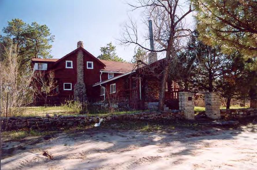
71
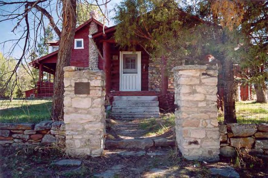
72
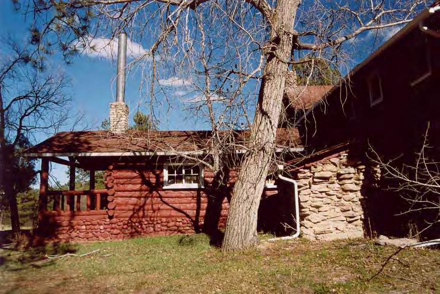
73
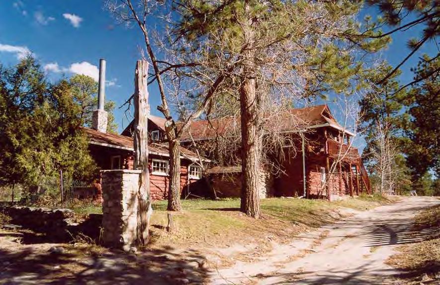
74
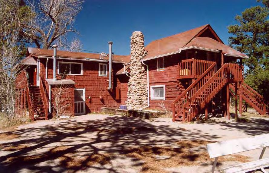
75
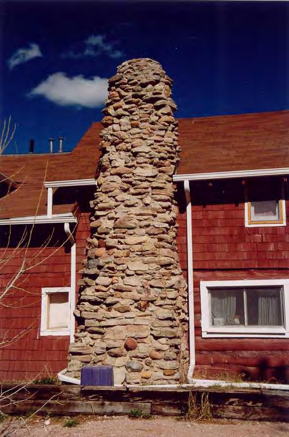
76
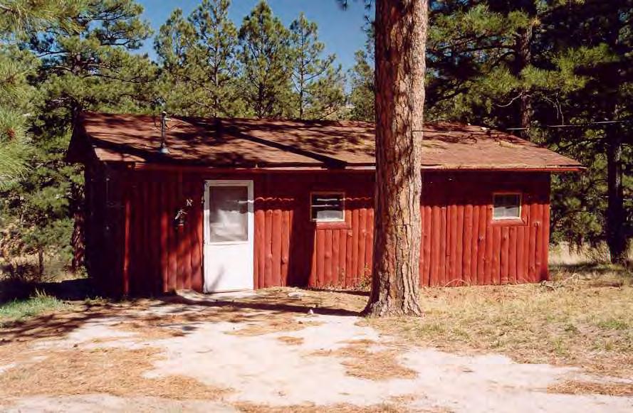
77
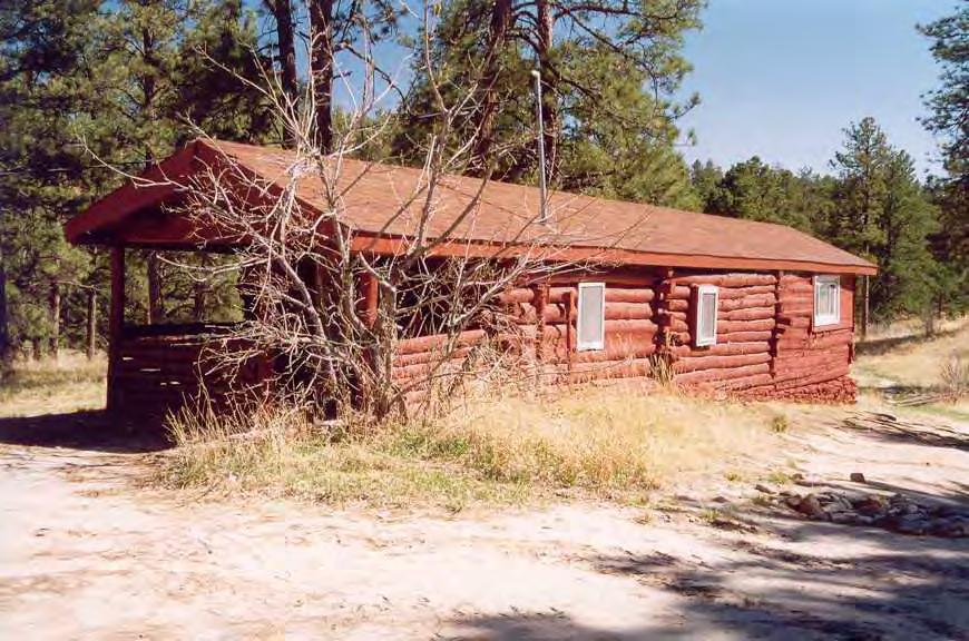
78
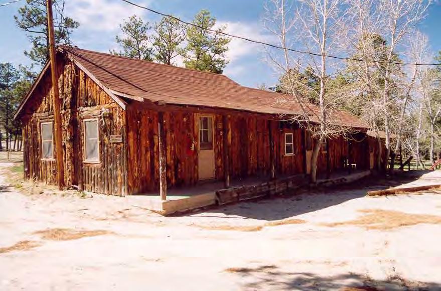
79
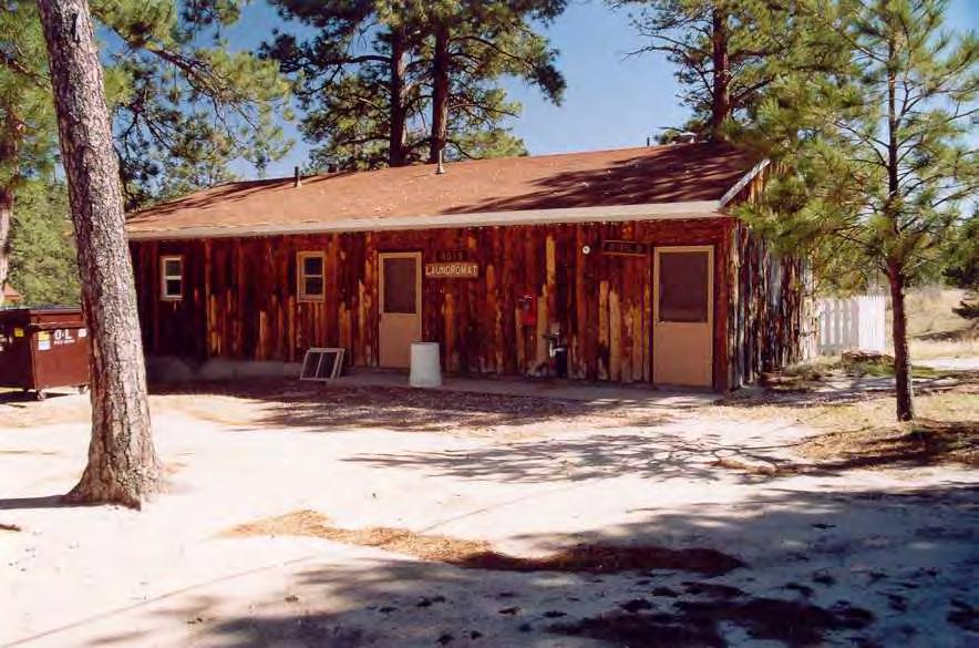
80
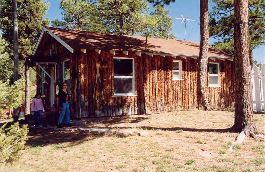
81

82
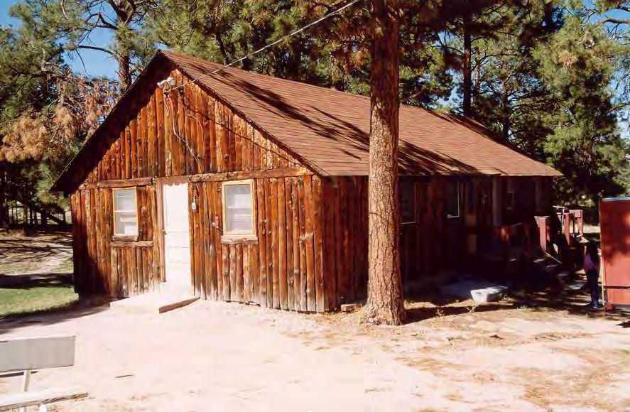
83
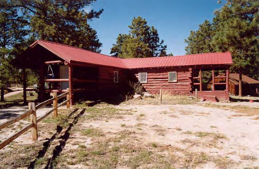
84
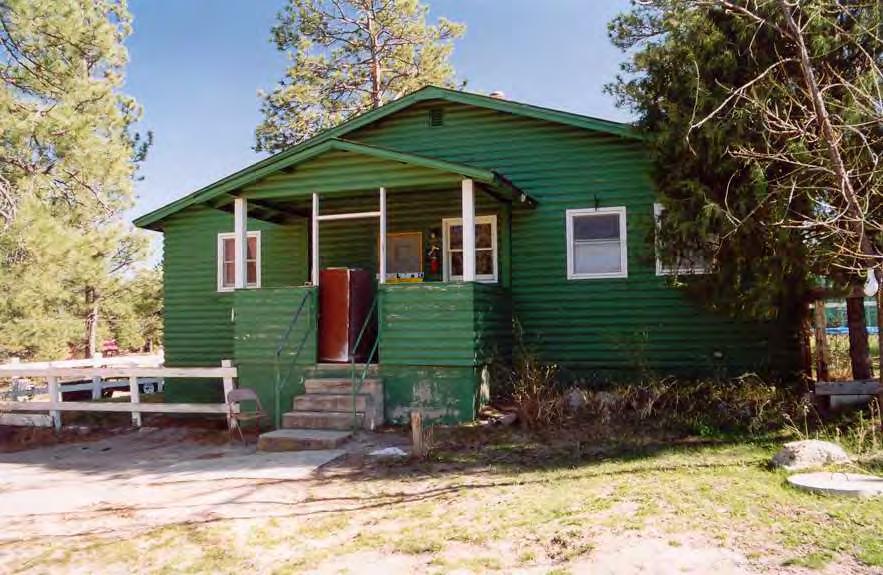
85
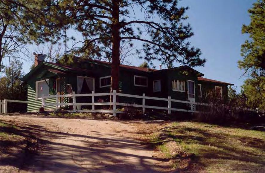
86
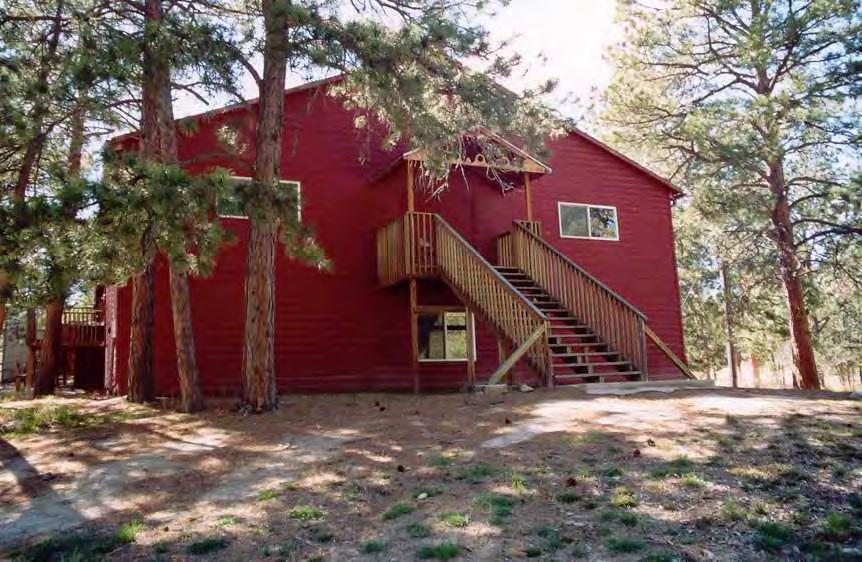
87
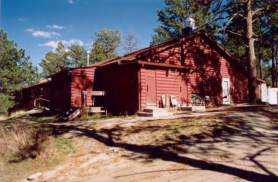
88
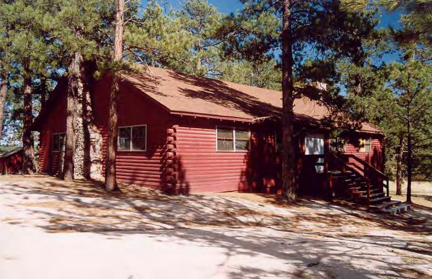
89
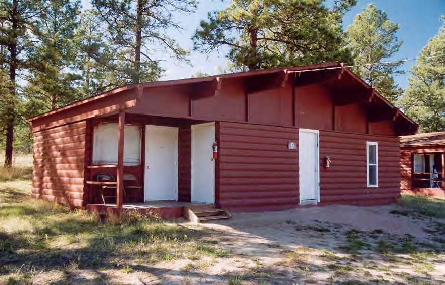
90
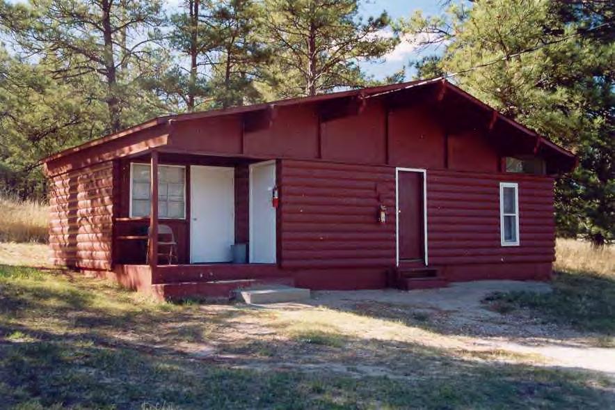
91
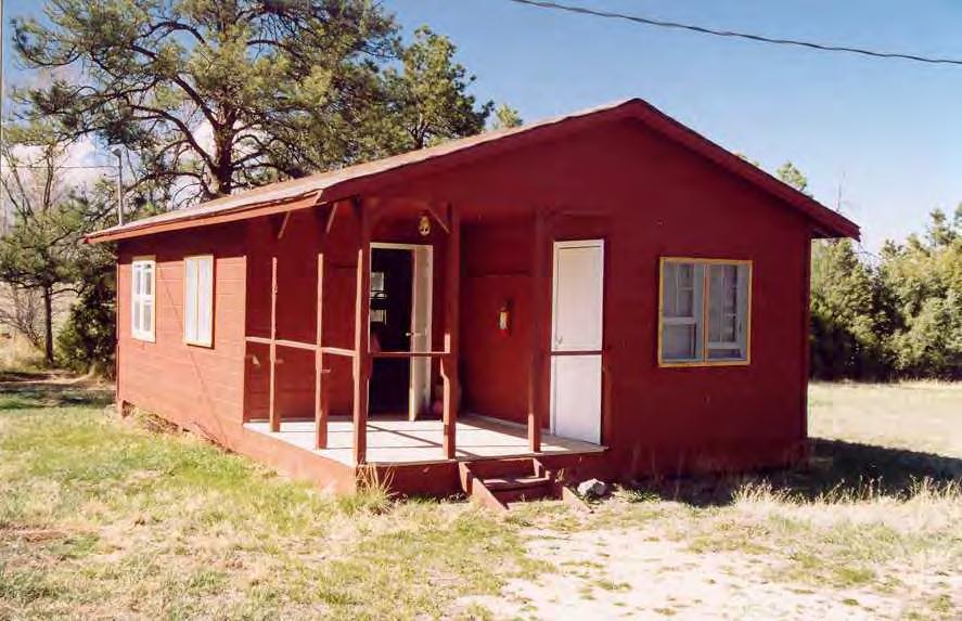
92
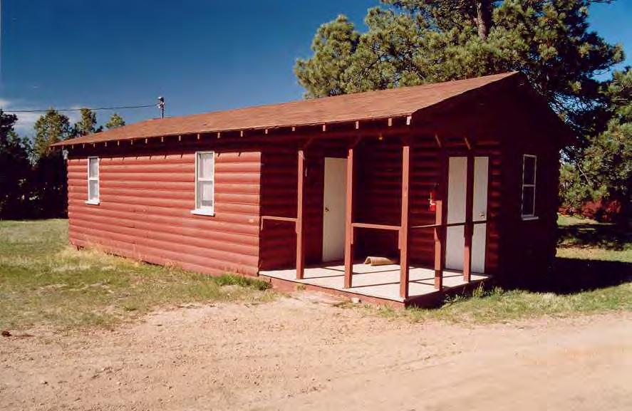
93
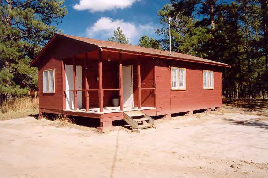
94
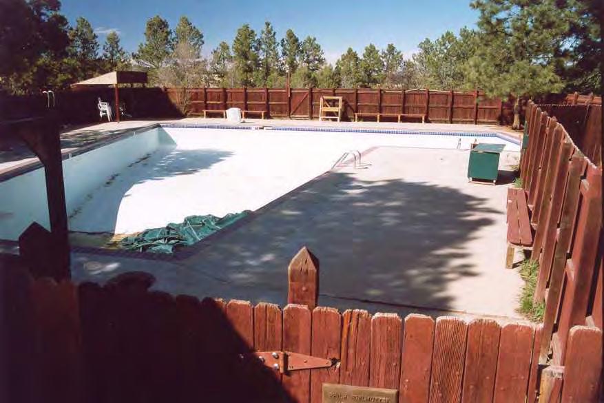
95
808 Cherry Avenue
 808 Cherry Avenue 104-0213-0059 Primary Resource Information: Single Dwelling, Stories 2.00, Style: Other, ca 1900 July 2006: This 2-story, 3-bay frame I-house features a central-front gable, a brick pier
Architectural Inventory Form
 OAHP1403 Rev. 9/98 COLORADO CULTURAL RESOURCE SURVEY Architectural Inventory Form Official eligibility determination (OAHP use only) Date Initials Determined Eligible- NR Determined Not Eligible- NR Determined
301 7½ Street SW
 301 7½ Street SW 104-0213-0072 Primary Resource Information: Single Dwelling, Stories 2.00, Style: Other, ca 1890 July 2006: This late-19th-century, 3-bay, 2-story, hip-roofed frame I-house features projecting
Town: Sharon Place (neighborhood or village): Sharon. ame of Area: Present Use: Date (month / year): July 2008
: Sharon. ame of Area: Present Use: Date (month / year): July 2008") FORM A - AREA MASSACHUSETTS HISTORICAL COMMISSION MASSACHUSETTS ARCHIVES BUILDING 220 MORRISSEY BOULEVARD BOSTON, MASSACHUSETTS 02125 Photograph Assessor s Sheets USGS Quad Area Letter Form Numbers in
FORM A - AREA MASSACHUSETTS HISTORICAL COMMISSION MASSACHUSETTS ARCHIVES BUILDING 220 MORRISSEY BOULEVARD BOSTON, MASSACHUSETTS 02125 Photograph Assessor s Sheets USGS Quad Area Letter Form Numbers in
NE¼ of NE¼ of NE¼ of NE¼ of section Roof configuration (enter one): Gabled Roof / Front Gabled Roof
: Gabled Roof / Front Gabled Roof") OAHP1403 Rev. 9/98 COLORADO CULTURAL RESOURCE SURVEY Official Eligibility Determination (OAHP use only) Date Initials Determined Eligible - National Register Architectural Inventory Form Determined Not
OAHP1403 Rev. 9/98 COLORADO CULTURAL RESOURCE SURVEY Official Eligibility Determination (OAHP use only) Date Initials Determined Eligible - National Register Architectural Inventory Form Determined Not
United States Department of the Interior National Park Service. Boundary Expansion Listed in National Register January 11, 2017
 NPS Form 10900-a (Rev. 8/2002) OMB No. 10240018 United States Department of the Interior National Park Service Boundary Expansion Listed in National Register January 11, 2017 National Register of Historic
NPS Form OMB No Exp Status occupied X unoccupied work in progress Accessible yes: restricted yes: unrestricted _5Lno
 NPS Form 10-900 OMB No. 1024-0018 Exp. 10-31-84 United States Department of the Interior National Park Service National Register of Historic Places Inventory Nomination Form See instructions in How to
 Page 1 Original Update HISTORICAL STRUCTURE FORM FLORIDA MASTER SITE FILE Consult Guide To Historical Structure Forms for detailed instructions Site # 8OR9844 Recorder # 26 Recorder Date 2/20/08 Site Name
Building Permit Application
 Building Permit Application Co-Owner Name Lot # Address City State Zip Phone (home) (cell) Contractor (if applicable) The above named co-owner hereby makes application to Cedar Shores Campground Condominium
Modular Log Cabins & Log Homes Alan's Factory Outlet Luray VA
 1 2 2 Your special place to reflect, retreat, and rejuvenate. Your Cabin - The Place Where The World Stands Still And Life Begins The Settler Cabin Weekend outings should be a time to relax and unwind
IMPORTANT NOTICE. Architectural Inventory Form COLORADO CULTURAL RESOURCE SURVEY I. IDENTIFICATION. 305 Eldorado Avenue 5BL.10471
 IMPORTANT NOTICE OAHP1403 Rev. 9/98 COLORADO CULTURAL RESOURCE SURVEY Architectural Inventory Form Page 1 This survey form represents an UNOFFICIAL COPY and is provided for informational purposes only.
NPS Form OMB No (Rev ) U. S. Department of the Interior Name of Property: Hungry Mother State Park Historic District
 U. S. Department of the Interior Name of Property: Hungry Mother State Park Historic District") NPS Form 10-900 OMB No. 1024-4018 (Rev. 10-90) U. S. Department of the Interior Name of Property: Location: 5. Classification Ownership of Property (Check as many boxes as apply) Category of Property (Check
NPS Form 10-900 OMB No. 1024-4018 (Rev. 10-90) U. S. Department of the Interior Name of Property: Location: 5. Classification Ownership of Property (Check as many boxes as apply) Category of Property (Check
1 Gildersleeve Wood (DHR # )
") GILDERSLEEVE WOOD 1 Gildersleeve Wood (DHR # 104-5092-0012) STREET ADDRESS: 1 Gildersleeve Wood MAP & PARCEL: 11-20 PRESENT ZONING: R-1U ORIGINAL OWNER: Lindsay Family ORIGINAL USE: PRESENT USE: PRESENT
GILDERSLEEVE WOOD 1 Gildersleeve Wood (DHR # 104-5092-0012) STREET ADDRESS: 1 Gildersleeve Wood MAP & PARCEL: 11-20 PRESENT ZONING: R-1U ORIGINAL OWNER: Lindsay Family ORIGINAL USE: PRESENT USE: PRESENT
ADDENDUM. Chain of Title. Block C, Lot 8-9. Adrian I. Velthuis and Floyd T. Grant to Lottie Thompson
 Chain of Title Block C, Lot 8-9 NLP 5175:842 October 18, 1979 NLP 4979:58 October 5, 1977 NLP 4763:448 May 11, 1977 Adrian I. Velthuis and Floyd T. Grant to Lottie Thompson Gentlemens II Properties, Inc.,
CITY OF MURFREESBORO HISTORIC ZONING COMMISSION. Regular Meeting June 19, :30 PM, Council Chambers, City Hall
 CITY OF MURFREESBORO HISTORIC ZONING COMMISSION Regular Meeting June 19, 2018 3:30 PM, Council Chambers, City Hall I. Call to Order and determination of a quorum II. Approve Minutes of the Regular Meeting
35 Bee Tree Park Planning Zone 3
 35 Bee Tree Park Planning Zone 3 2701 Finestown Road Visit Date: August 2016 St. Louis County Parks Master Plan Page 1 35 Bee Tree Park 2701 Finestown Road St. Louis County Parks Master Plan Planning Zone
Architectural Inventory Form
 COLORADO CULTURAL RESOURCE SURVEY Page 1 of 3 Official Eligibility Determination (OAHP use only) Rev. 9/98 OAHP1403 Date Initials Determined Eligible National Register Determined Not Eligible National
Appendix E Historic Property Inventory Forms
 Appendix E Historic Property Inventory Forms TECHNICAL MEMORANDUM Sound Transit Federal Way Link Extension WISAARD Survey Entries PREPARED FOR: COPY TO: PREPARED BY: Sound Transit Alisa Swank/ CH2M MaryNell
PROJECT: Rehabilitate Historic Bathhouses for Adaptive Use
 LOCATION: Hot Springs National Park, Hot Springs Arkansas SIZE: Approximately 105,000 sf among six buildings DATE: 2003-present ROLE: Project Manager for Historic Structure Reports, pre-design through
Sky Ranch National Register of Historic Places Registration Form
 University of Wyoming Wyoming Scholars Repository Sky Ranch Historic District Historic Preservation 7-2005 Sky Ranch Registration Form Mary Humstone University of Wyoming, humstone@uwyo.edu Follow this
; * --.-.,., rj ; United States Department of the Interior \ ' '"] I National Park Service
![; * --.-.,., rj ; United States Department of the Interior \ ' '] I National Park Service](/thumbs/88/117765392.jpg "; * --.-.,., rj ; United States Department of the Interior \ ' '] I National Park Service") NPS Form 10-900 OMB No. 1024-0018 (Rev. 10-90) : / i' -_ :. - : ; ; * --.-.,., rj ; United States Department of the Interior \ ' '"] I National Park Service NATIONAL REGISTER OF HISTORIC PLACES REGISTRATION
NPS Form 10-900 OMB No. 1024-0018 (Rev. 10-90) : / i' -_ :. - : ; ; * --.-.,., rj ; United States Department of the Interior \ ' '"] I National Park Service NATIONAL REGISTER OF HISTORIC PLACES REGISTRATION
Photo Album Intact/Slightly Altered. Eligible, see Statement of Significance. Roadside Development on Minnesota Trunk Highways,
 Historic Name CS # 5202 Other Name SHPO Inv # Location Hwy District Reference City/Township County Courtland Township Nicollet Acres 4.6 Twp Rng Sec 110N 30W Sec 22 Rest Area Class 4 USGS Quad UTM New
Welcome to Badgerland Council s property photos and information.
 Welcome to Badgerland Council s property photos and information. 1 In addition to the four Service Centers located in Beloit, La Crosse, Platteville, and Madison, Badgerland Council owns and maintains
Historic Inventory Report
 Location Field Site No. 3394-134 DAHP No. Historic Name: Common Name: Cabinetrends Property Address: 24619 Pacific Hwy S, Kent, WA 98032 Comments: Tax No./Parcel No. 3601800165 Plat/Block/Lot Acreage.24
Maryland Historical Trust Inventory No. PG: 86A-026 Maryland Inventory of Historic Properties Form
 Inventory No. PG: 86A-026 Maryland Inventory of 1. Name of Property (indicate preferred name) historic other 2. Location street and number 12811 Croom Road not for publication city, town Naylor vicinity
Brinker Creek Ranch. Colorado - Routt County - Yampa
 Located at the base of the Flattops Range in the Steamboat/Vail corridor, Brinker Creek Ranch consists of 1,451 acres ideally suited for high country grazing and native grass hay production. Traditionally
THE BARNACLE 3485 MAIN HIGHWAY
 THE BARNACLE 3485 MAIN HIGHWAY Designation Report City of Miami REPORT OF THE CITY OF MIAMI PLANNING AND ZONING DEPARTMENT TO THE HISTORIC AND ENVIRONMENTAL PRESERVATION BOARD ON THE POTENTIAL DESIGNATION
COLORADO HISTORICAL SOCIETY
 SECTION I COLORADO HISTORICAL SOCIETY OAHP1414 (Rev. 11/2001) COLORADO STATE REGISTER OF HISTORIC PROPERTIES NOMINATION FORM Name of Property Historic Name Boor Ranch/Boor Homestead Other Names Redmond
Lake Wissota Access Locations within the LaFayette Township. By Chad Martin
 Lake Wissota Access Locations within the LaFayette Township By Chad Martin Anson/ Wissota Access Point # 1 Road: 195 th St. Associated Fire Numbers: 13294 Defining Characteristics: Forested from road
the Webb Ranch Resort
 the Webb Ranch Resort Recreation... Privacy... Comfort... The Webb Ranch Resort is located approximately 6 miles northwest of Pinon, New Mexico. Featuring a beautifully designed, custom log home, the 212
BAsin. - Ranch - Offered at $11,500,000.
 BAsin Greenfield, California Offered at $11,500,000 www.clarkcompany.com 1031 Pine Street Paso Robles, California 93446 Phone: (805) 238-7110 Fax: (805) 238-1324 info@clarkcompany.com BAsin Description
Architectural Inventory Form
 COLORADO CULTURAL RESOURCE SURVEY Page 1 of 3 Official Eligibility Determination (OAHP use only) Rev. 9/98 OAHP1403 Date Initials Determined Eligible National Register Determined Not Eligible National
ate: AR County: Pulaski Code: AR Zip Code: Noncontributing buildings sites structures objects Total
 Mims-Ereedlove-Priest-Weatherton House Name of Property Little Rock, AR County and State ~- -,s Form 10-900 'V. 8-86) OMB No. 1024-0018 United States Department of the Interior National Park Service NATIONAL
FLAGLER WORKER S HOUSE FORT DALLAS PARK S.E. 4 STREET
 FLAGLER WORKER S HOUSE FORT DALLAS PARK 60-64 S.E. 4 STREET Designation Report City of Miami REPORT OF THE CITY OF MIAMI PLANNING DEPARTMENT TO THE HERITAGE CONSERVATION BOARD ON THE POTENTIAL DESIGNATION
SURVEY OF PUBLIC HOUSES WESTON TURVILLE
 BUCKINGHAMSHIRE ARCHAEOLOGICAL SOCIETY HISTORIC BUILDINGS GROUP SURVEY OF PUBLIC HOUSES IN THE PARISH OF WESTON TURVILLE BUCKINGHAMSHIRE A record of extant buildings that are currently or were formerly
DESIGNATION REPORT KENNEDY-BAKER-WALKER-SHERRILL HOUSE (1849) 9320 KINGSTON PIKE (CLT ) KNOXVILLE, TENNESSEE July 12, 2007
 9320 KINGSTON PIKE (CLT ) KNOXVILLE, TENNESSEE July 12, 2007") DESIGNATION REPORT KENNEDY-BAKER-WALKER-SHERRILL HOUSE (1849) 9320 KINGSTON PIKE (CLT 132-027) KNOXVILLE, TENNESSEE July 12, 2007 Description The Kennedy-Baker-Walker-Sherrill House is located on the south
DESIGNATION REPORT KENNEDY-BAKER-WALKER-SHERRILL HOUSE (1849) 9320 KINGSTON PIKE (CLT 132-027) KNOXVILLE, TENNESSEE July 12, 2007 Description The Kennedy-Baker-Walker-Sherrill House is located on the south
MINNESOTA HISTORIC.PROPERTIES INVENTORY FORM. Yes_ No X Restricted
 HISTORIC NAME: CURRENT NAME: LEGAL DESC.: MINNESOTA HISTORIC.PROPERTIES INVENTORY FORM Hartley Sugar Camp W % of Gov't. Lot 3 and T55, R24, Sec. 9 COUNTY: Itasca CITY/TWP.: Trout Lake Twp. ADDRESS: of
Portway Farm, Twyford
 Portway Farm, Twyford Buckinghamshire Archaeological Society HISTORIC BUILDING REPORT / April 2011 Including HS2 high-speed rail line Impact Assessment SURVEY AND REPORT: Sue Fox and John Brushe Report
CAMPSITE 411. Girl Scouts of Greater Atlanta, Inc.
 CAMPSITE 411 Girl Scouts of Greater Atlanta, Inc. What is provided for us at each campsite/cabin? Although each living unit (tents or cabins) is unique, you can expect to find certain unit equipment in
Address 347 Whitney Street. East elevation, camera facing southwest.
 FORM B BUILDING Assessor s Number USGS Quad Area(s) Form Number MASSACHUSETTS HISTORICAL COMMISSION MASSACHUSETTS ARCHIVES BUILDING 220 MORRISSEY BOULEVARD BOSTON, MASSACHUSETTS 02125 Town Northborough
The George Rieley home place, built 1852, from bricks molded and baked on the premises.
 The George Rieley home place, built 1852, from bricks molded and baked on the premises. 1. SUBJECT: Old Riley [sic] Place. 2. LOCATION: 1/16 mile east of Blue Ridge Va. on Route /460. House on north side
National Register of Historic Places Registration Form
 NPS Form 10-900 OMB No. 10024-0018 (Oct. 1990) Registration Form This form is for use in nominating or requesting determinations for individual properties and districts. See instructions in How to Complete
Felden Orchard I Bulstrode Lane I Felden. aitchisons.co.uk TOWN & COUNTRY
 Felden Orchard I Bulstrode Lane I Felden aitchisons.co.uk TOWN & COUNTRY Felden Orchard I Bulstrode Lane I Felden HP3 0BP A Home with Immense Character Felden is a delightful hamlet surrounded by rolling
Real Log Park Model Cabins. Real, Rustic Log Cabins on Wheels!
 Real Log Park Model Cabins Real, Rustic Log Cabins on Wheels! 717-445-5522 www.lancasterlogcabins.com Why Lancaster Log Cabins? Lancaster Log Cabins has been in the log cabin industry since 1990! We pride
TAYLOR CANYON RANCH COLORADO - ROUTT COUNTY - STEAMBOAT SPRINGS
 TAYLOR CANYON RANCH COLORADO - ROUTT COUNTY - STEAMBOAT SPRINGS Tucked up against the steep valley shaped by Mt. Pau and rising to the Routt National Forest, Taylor Canyon Ranch is an easily accessible,
RAY YENKANA Willowbrook Cr, Dawson Creek BC Canada $2,847,000
 1716 Willowbrook Cr, Dawson Creek BC Canada For SALE $2,847,000 This is a rare find, 32 townhomes in Dawson Creek, BC. Excellent investment in a single title multi family complex. Vendor has upgraded this
Property Profile~ Crater Lake Resort. Chris Martin Wes Walton Hwy 62, Chiloquin OR Licensed Real Estate Brokers in the State of Oregon
 Property Profile~ 50711 Hwy 62, Chiloquin OR 97624 Crater Lake Resort Chris Martin Wes Walton Licensed Real Estate Brokers in the State of Oregon Chris Cell: 541-660-5111 Chris Email: Chris@LandAndWildlife.com
APPENDIX K: BUILT HERITAGE AND CULTURAL HERITAGE LANDSCAPES
 APPENDIX K: BUILT HERITAGE AND CULTURAL HERITAGE LANDSCAPES TABLE 1: Built Resources (BHR) and Cultural Heritage Landscapes (CHL) Within and Adjacent to the West Whitby Secondary Plan Area Site # 1. CHL
City of Burlington Historic Preservation Commission Meeting Minutes: September 4, 2013
 City of Burlington Historic Preservation Commission Meeting Minutes: September 4, 2013 The City of Burlington Historic Preservation Commission held its regular monthly meeting on Wednesday, September 4,
Architectural Analysis in Western Palenque
 Architectural Analysis in Western Palenque James Eckhardt and Heather Hurst During the 1999 season of the Palenque Mapping Project the team mapped the western portion of the site of Palenque. This paper
NEWBORO AND PORTLAND HARBOUR REDVELOPMENT PLANS
 INTRODUCTION The Municipal docks in both Newboro and Portland were transferred to the Township of Rideau Lakes by Parks Canada in 2002. Little has been done to improve the docks physical condition or role
NATIONAL REGISTER OF HISTORIC PLACES REGISTRATION FORM
 (Rev. 10-90) NPS Form 10-900 OMB No. 1024-0018 NATIONAL REGISTER OF HISTORIC PLACES REGISTRATION FORM This form is for use in nominating or requesting determinations for individual properties and districts.
29 Plas Derwen. Exploring Abergavenny
 29 Plas Derwen Exploring Abergavenny Cover: rhythm 2 plas derwen EXPLORING ABERGAVENNY For several years the Abergavenny and District Civic Society has been studying the streets, spaces and buildings of
Friends Meeting House, Warwick. 39 High Street, Warwick, CV34 4AX. National Grid Reference: SP Statement of Significance
 Friends Meeting House, Warwick 39 High Street, Warwick, CV34 4AX National Grid Reference: SP 28071 64737 Statement of Significance Warwick Meeting House has exceptional heritage significance as a fine
Maryland Historical Trust Inventory No. PG: 75A-007 Maryland Inventory of Historic Properties Form
 Inventory No. PG: 75A-007 Maryland Inventory of 1. Name of Property (indicate preferred name) historic other 2. Location street and number 3101 Ritchie Road not for publication city, town Forestville vicinity
HISTORIC PRESERVATION COMMISSION HEARING MINUTES
 HISTORIC PRESERVATION COMMISSION HEARING MINUTES APRIL 22, 2010 Commissioners Tim Daniel, Chairman Scott Winnette, Vice Chairman Timothy Wesolek Robert Jones Joshua Russin (not present) Aldermanic Representative
Gilpin County Historic Preservation Advisory Commission. 114 Redtail Road Historic Eligibility Review
 Gilpin County Historic Preservation Advisory Commission 114 Redtail Road Historic Eligibility Review Deon Wolfenbarger Three Gables Preservation February 18, 2017 BACKGROUND The purpose of the review is
Hwy Retaining Wall/ Sea Wall. Not Eligible, see Statement of Significance Also member of listed NR district: Mantorville Historic District
 Historic Name CS # 2007 Other Name SHPO Inv # Location E and W sides of TH 57 between 6th St and 7th St Hwy District Reference City/Township County Mantorville, City of Dodge Acres Twp Rng Sec 107N 16W
Bulkley Canyon Farms Ltd. Smithers B.C.
 Remax Bulkley Valley Charlie McClary 8462 Johnson Road, Smithers, BC, V0J 2N1 Email cmcclary@uniserve.com (250) 877-1770 Cell (250) 847-5999 Office www.charliemcclary.com Bulkley Canyon Farms Ltd. Smithers
THE GHOST ROSE RANCH. Randy J. Wood Qualifying Broker Cell:
 Wild West Properties, LLC 7020 Santa Marisa, NE Albuquerque, NM 87113 505-836-4558 http://www.wildwestproperties.com/ Randy J. Wood Qualifying Broker Cell: 505-980-8019 E-mail: rjwood5@comcast.net THE
Rental Opportunities
 CAMP COURAGEOUS Rental Opportunities This document describes the facilities available for rent. Please refer to the Camp Courageous Rental Rates document for all current rental rates. (available at www.campcourageous.org)
Change dormers and main entry on the river side of the house. Site: 43 Riverbank Road, Block 10 Lot 3
 City of Burlington Historic Preservation Commission Meeting Minutes: December 2, 2015 The City of Burlington Historic Preservation Commission held its regular monthly meeting on Wednesday, December 2,
Historical value The building was erected on a new site to serve a new meeting and in itself is of low historical value.
 Quaker Meeting House, Welwyn Garden City 109 Handside Lane, Welwyn Garden City, Hertfordshire, AL8 6SP National Grid Reference: TL 23149 12617 Statement of Significance As first built in 1926 to the designs
Subject to sale, withdrawal, or error.
 The Crawford L Bar Ranch is located approximately 40 air miles west of Albuquerque, New Mexico. This ranch truly epitomizes the description of New Mexico being the Land of Enchantment. The topography and
BAXTER LAKE RECREATION AREA ASSOCIATION
 Baxter Lake Recreation Area Association SITE CONTROL COMMITTEE RULES TABLE OF CONTENTS Notes 2 Introduction 2 Campsites 2 Common Grounds 2 Green Areas 2 Cutting Trees 3 Application for Site Alteration
street & number: COUNTY ROUTE 3, HC-88, BOX 17 not for publication: N/A city/town: WHEELER vicinity: X state: WV county: WEBSTER code: 101 zip code:
 NPS Forn 10-900 OMB No. 10024-0018 (Oct. 1990) United States Department of the Interior National Park Service NATIONAL REGISTIR OF HISTORIC PLACES REGISTRATICN FCRX =========================================================---------=======
Great Trail Camp. As of October 1, 2009 all of main side is closed except for the cabin at Outpost, which is being used for the camp monitor.
 Great Trail Camp Great Trail Camp is located in beautiful Malvern, Ohio, on 276 acres of rolling hills with a two and a half acre pond. It once was an old Native American trail overlooking the famous Great
Kitchens Over $100,000. McDonald Remodeling, Inc.
 Kitchens Over $100,000 McDonald Remodeling, Inc. PROJECT DESCRIPTION: Goals: The owners simply wanted a functioning kitchen. A functioning kitchen that included connection to a meaningful rear entry, thoughtful
HISTORIC SITE FORM HISTORIC SITES INVENTORY
 HISTORIC SITE FORM HISTORIC SITES INVENTORY 1 IDENTIFICATION Name of Property: House at 569 Park Avenue PARK CITY MUNICIPAL CORPORATION (10-08) Address: 569 Park Avenue City, County: Park City, Summit
Cranberry Lake Farm. By Alicia McCullough for the Oakland Township HDC
 Cranberry Lake Farm By Alicia McCullough for the Oakland Township HDC Cranberry Lake Farm s History Cranberry Lake Farm was purchased by Seymour Fletcher in 1837 from the Federal Government. The development
Smiths Hill House West Farleigh Kent
 Smiths Hill House West Farleigh Kent Smiths Hill House Smiths Hill - ME15 0PQ Offers In The Region Of 1,000,000 (Freehold) For Sale Extensive unlisted 5 bedroom detached farmhouse full of character situated
17 Mathilda Welmering Park Planning Zone 3
 17 Mathilda Welmering Park Planning Zone 3 8301 Mathilda Visit Date: September 2016 St. Louis County Parks Master Plan Page 1 Description: The six acre Mathilda Welmering Park is named for two streets
CAMPSITE 411. Girl Scouts of Greater Atlanta, Inc.
 CAMPSITE 411 Girl Scouts of Greater Atlanta, Inc. What is provided for us at each campsite/cabin? Although each living unit (tents or cabins) is unique, you can expect to find certain unit equipment in
TYPE ALL ENTRIES -- COMPLETE APPLICABLE SECTIONS. Elsenhower Memorial Chapel (unofficially)
") Form No 10-306 (Rev 10-74) UNlTEDSTATtS DEPARTMENT OK THt INTERIOR NATIONAL PARK SERVICE NATIONAL REGISTER OF HISTORIC PLACES INVENTORY - NOMINATION FORM FOR FEDERAL PROPERTIES SEE INSTRUCTIONS IN HOW
Form No 10-306 (Rev 10-74) UNlTEDSTATtS DEPARTMENT OK THt INTERIOR NATIONAL PARK SERVICE NATIONAL REGISTER OF HISTORIC PLACES INVENTORY - NOMINATION FORM FOR FEDERAL PROPERTIES SEE INSTRUCTIONS IN HOW
Glebe Barn, Spenbrook Road, Newchurch-in- Pendle Imposing stonebuilt detached barn conversion 420,000
 Glebe Barn, Spenbrook Road, Newchurch-in- Pendle Imposing stonebuilt detached barn conversion 420,000 4 double bedrooms Conservatory, double garage Dining kitchen, 2 large receptions Desirable rural village
HB/10/06/003 Camus House, 46 Lisky Rd, Strabane. Foyle Valley
 Asset Ref No. Heritage Type House, Gates, Outbuildings, Walling Including Around Flax Drying Green. Built Post-Medieval house Location OS 6-inch map sheet Townland Parish LCA Foyle Valley ITM Coordinates
Maryland Historical Trust Inventory No. PG: 86A-003 Maryland Inventory of Historic Properties Form
 Inventory No. PG: 86A-003 Maryland Inventory of 1. Name of Property (indicate preferred name) historic other 2. Location street and number 12005 Duley Station Road not for publication city, town Upper
Proposed East Sanford Historic District DRAFT
 Proposed East Sanford Historic District DRAFT Inventory List The following inventory list provides basic information for all properties in the East Sanford Historic District. Included are each property
No 30 x 48 space is provided for a wheelchair under the picnic table.
 ITEM: LLOYD PARK PICNIC TABLE ADA GUIDELINE: 305, 902.2 No 30 x 48 space is provided for a wheelchair under the picnic table. Remove one of the picnic table arms. Photo of Picnic Table on the bluff PARK:
Riverside County Landmark Application Lawler Lodge
 November 20, 2014 Agenda Item: 9.3 Job Code: 2014-11 Riverside County Landmark Application Lawler Lodge 1. SITE NAME: a. Historic: Lawler Park, Lawler Lodge b. Common: Lawler Lodge 2. LOCATION: a. Address:
county Lonoke code 085 zip code
 ~~~~~~~~~~~ AR NPS Form I 0-900 (Oct. 1990) United States Department of the Interior National Park Service National Register of Historic Places egistration Form w-l.3-1 / OMB No. 10024-0018 This form is
- Ranch - rawitser. paso robles, California.
 rawitser - Ranch - paso robles, California www.clarkcompany.com 1031 Pine Street Paso Robles, California 93446 Phone: (805) 238-7110 Fax: (805) 238-1324 info@clarkcompany.com RAWitser - Ranch - 1142 San
37755 RCR 33 (Lot 1 Star Buck Subdivision) Steamboat Springs, Colorado Website: BuckRanch.com
 Steamboat Springs, Colorado Website: BuckRanch.com") 37755 RCR 33 (Lot 1 Star Buck Subdivision) Steamboat Springs, Colorado Website: www.star BuckRanch.com Offered at $925,000 MLS# 134040 Listed by Colleen de Jong Prudential Steamboat Realty (970) 846 5569
37755 RCR 33 (Lot 1 Star Buck Subdivision) Steamboat Springs, Colorado Website: www.star BuckRanch.com Offered at $925,000 MLS# 134040 Listed by Colleen de Jong Prudential Steamboat Realty (970) 846 5569
National Register of Historic Places Inventory Nomination Form. 1. Name. 2. Location. 3. Classification. 4. Owner of Property
 NFS Form 10-900 (3-82) 0MB No. 1024-0018 Expires 10-31-87 United States Department of the Interior National Park Service National Register of Historic Places Inventory Nomination Form See instructions
Making Camp. Little did Cynthia and Kirk Dupps know that their. Arkansas family creates a fun-filled getaway. Story by Tracy Maruschak
 Making Camp Arkansas family creates a fun-filled getaway Story by Tracy Maruschak Photography by Brad Simmons Little did Cynthia and Kirk Dupps know that their search for the perfect property would lead
Northeast Quadrant Distinctive Features
 NORTHEAST QUADRANT Northeast Quadrant Distinctive Features LAND USE The Northeast Quadrant includes all the area within the planning area that is east of Interstate 5 and to the north of State Route 44.
Camp Hugh Taylor Birch
 Camp Hugh Taylor Birch Tecumseh Council # 439 Tecumseh Council #439 326 S. Thompson Ave. Springfield, OH 45506 (937) 325-6449 Camp Hugh Taylor Birch 4057 Swimming Pool Rd. Yellow Springs, OH 45387 (937)
CAMP SLEEPING FACILITIES <«- Plate III L-
 CAMP SLEEPING FACILITIES CAMP SLEEPING FACILITIES St. Croix Recreational Demonstration Area. Minnesota Montserrat Recreational Demonstration Area, Missouri CAMPERS'
The meeting house is a converted Plymouth Brethren Chapel which originally was two cottages. It has medium significance.
 Quaker Meeting House, Ashburton Foales Court, off North Street, Ashburton, Devon, TQ13 7QE National Grid Reference: SX 75574 69951 Statement of Significance The meeting house is a converted Plymouth Brethren
SOUTH LODGE, HEATHSIDE, HAMPSTEAD, LONDON, NW3 1BL
 Anthony Casingena Property Consultants 10/12 Perrins Court, Hampstead, London, NW3 1QS Tel: +44 (0)20 7433 3933 Email: info@anthonycasingena.com www.anthonycasingena.com A HANDSOME GRADE 2 LISTED GEORGIAN
SWAN CREEK VILLAGE HOMEOWNERS ASSOCIATION. P.O. Box Bountiful, UT
 RV PARK REQUIREMENTS SWAN CREEK VILLAGE HOMEOWNERS ASSOCIATION P.O. Box 1188 Bountiful, UT 84011-118 The following RV Park requirements were voted on and approved by the Swan Creek Village HOA Board of
$2,100, RILEY RANCH RILEY, OR REDUCED!! CASH ACRES OF DEEDED ACRES. BLM PERMIT ONLY 3 MILES AWAY 654 AUMs WATER RIGHTS TWO HOMES
 64347 HARNEY AVE. CRANE, OR 97732 637.15 DEEDED ACRES BLM PERMIT ONLY 3 MILES AWAY 654 AUMs 605.2 ACRES OF WATER RIGHTS RILEY, OR TWO HOMES NICE SHOP BIG BARN SCALES REDUCED!! $2,100,000.00 CASH ALL INFORMATION
Panoramic Views ~11,800 SF Lodge Office & Barns Borders to Mark Twain National Forest. Contact RE Bid Sales for Property & Auction Info, Terms, Etc.
 ELK MOUNTAIN RANCH: For Immediate Sale 800 ACRES WITH LODGE SHANNON COUNTY, MO BUY NOW: Bidding Open, Sellers May Sell Immediately LIVE AUCTION: Feb. 7, 2014 Panoramic Views ~11,800 SF Lodge Office & Barns
Commonwealth of Massachusetts Massachusetts Historical Commission 220 Morrissey Boulevard, Boston, Massachusetts
 Inventory No: Historic Name: Common Name: Address: HRV.165 Blood, Joseph House Farnsworth, Jonathan - Beaman, Jonathan House 74 Poor Farm Rd City/Town: Village/Neighborhood: Local No: 9-17 Year Constructed:
Angela Nicholas, Special to Asheville Citizen Times Published 6:00 a.m. ET Sept. 13, 2018 Updated 6:32 a.m. ET Sept. 13, 2018
 Angela Nicholas, Special to Asheville Citizen Times Published 6:00 a.m. ET Sept. 13, 2018 Updated 6:32 a.m. ET Sept. 13, 2018 Texans Jim and Sabrina Watson were looking for long, layered views when they
L o s t I n T i m e R a n c h WIBAUX, MONTANA
 L o s t I n T i m e R a n c h WIBAUX, MONTANA Offered by Jacob L. Korell Broker/Owner Member of Landmark of Billings, Inc. 1925 Grand Avenue, Suite 143 Billings, MT 59102 OFFICE: (406) 248-3101 CELL: (406)
Seaforth Walking Tour
 Seaforth Walking Tour 1: Victoria Park The land for Victoria Park was donated to the Town by Dr. William Gouinlock in 1875, (one year after Seaforth was officially incorporated). The bandshell was constructed
Houses on the east side of River Street, camera facing northeast. Date (month/year) March 2009
 March 2009") FORM A - AREA MASSACHUSETTS HISTORICAL COMMISSION MASSACHUSETTS ARCHIVES BUILDING 220 MORRISSEY BOULEVARD BOSTON, MASSACHUSETTS 02125 Assessor s Sheets USGS Quad Area Letter Form Numbers in Area Shrewsbury
FORM A - AREA MASSACHUSETTS HISTORICAL COMMISSION MASSACHUSETTS ARCHIVES BUILDING 220 MORRISSEY BOULEVARD BOSTON, MASSACHUSETTS 02125 Assessor s Sheets USGS Quad Area Letter Form Numbers in Area Shrewsbury
Our Baker s Peak adventure started in September of 1998 when Bob Dickey, the previous owner of tract #85, signed on the dotted line and 35.
 This is the view from our porch cabin at Baker s Peak. The picture was taken in May (2001 as I recall). With all due respect to the late John Denver, this is almost heaven.! 1 Our Baker s Peak adventure
Total 1 Total. Current Functions (Enter categories from instructions) Materials (Enter categories from instructions)
 Materials (Enter categories from instructions)") Site Inventory Form State Inventory No. 29-00962 New Supplemental State Historical Society of Iowa Part of a district with known boundaries (enter inventory no.) 29-03685 (November 2005) Relationship:
Site Inventory Form State Inventory No. 29-00962 New Supplemental State Historical Society of Iowa Part of a district with known boundaries (enter inventory no.) 29-03685 (November 2005) Relationship: