National Register of Historic Places Inventory Nomination Form. 1. Name. 2. Location. 3. Classification. 4. Owner of Property
|
|
|
- Flora Hawkins
- 6 years ago
- Views:
Transcription
1 NFS Form (3-82) 0MB No Expires United States Department of the Interior National Park Service National Register of Historic Places Inventory Nomination Form See instructions in How to Complete National Register Forms Type all entries complete applicable sections 1. Name For NPS use only received QEC i 2 & date entered historic Gully Homestead and or common 2. Location Gully Homestead street & number 200 S. Chambers Rd n/a not for publication city, town Aurora JlL^icinity of state Colorado code 08 county Arapahoe code Classification Category Ownership district X public y building(s) private structure both site Public Acquisition object n ' ^n process JL/abeing considered 4. Owner of Property Status occupied x unoccupied work in progress Accessible ^ yes: restricted - yes: unrestricted no Present Use agriculture commercial educational entertainment government industrial military X museum park private residence religious scientific transportation other: name street & number City of Aurora 1470 S. Havana St. city, town Aurora vicinity of state Colorado 5. Location of Legal Description courthouse, registry of deeds, etc. Arapahoe County Courthouse street & number 5334 S. Prince St. city, town Littleton state Colorado 6. Representation in Existing Surveys Aurora Historic Preservation title Inventory, Volume I has this property been determined eligible? yes _x_ no date 1978 federal _K_ state county local depository for survey records Colorado Historical Society, OAHP, 1300 Broadway city, town Denver state Colorado 802D3

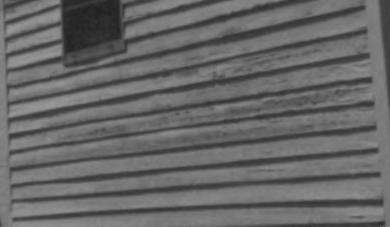
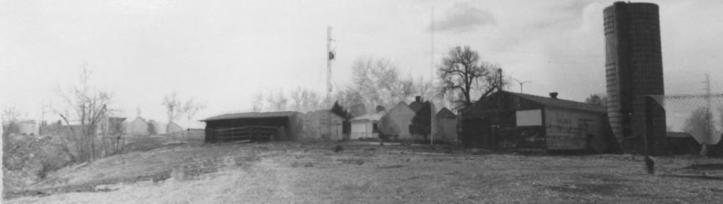
2 7. Description Condition excellent X good fair deteriorated ruins unexposed Check one unaltered ^ altered Check one V" original site movco ddtq 1978, 1983 Describe the present and original (if known) physical appearance The Gully Homestead House is located on the southern edge of the Bresnahan Ranch Complex, which lies just northeast of the intersection of East Alameda and South Chambers Road in Aurora. The homestead house faces south, with a small stable situated to the southeast, the only other structure moved from the original site. The setting is rural, located on 137 acres owned by the city of Aurora and preserved in its natural state. Willows, cottonwoods, wildflowers, and wild grasses cover the surrounding area. Tollgate Creek passes to the east of the site, and the Highline Canal runs just south of the homestead house. The Gully House is a single detached, frame dwelling with gabled roof, and a T-shaped plan. The one and a half story front portion features a central entrance flanked by windows on either side. The windows are wood frame, double-hung, six over six sash. Each of the gable walls contain one ground floor window and one smaller loft window. The front door is wood frame, with plain surrounds. The shed-roofed front porch extends across the full width of the facade and is supported by slender wood columns with plain caps and bases. There are three single brick chimneys one on the north end and used for the cooking stove; one on the west end; and one on the east end. There are no fireplaces in the structure. The one-story rear section features a gabled roof, a door and a six over six sash window on the west side, and a small window identical to the loft windows and another door on the east side. The uncovered porch on the west wall has a wood plank floor. A sleeping porch (date of construction unknown) on the east side was not reconstructed. There are three rooms and a loft on the interior. Where possible, the original lath and plaster walls have been restored, and each room has been painted in what was determined to be original colors. Each room features wood floors, molded baseboards, and tongue-and-groove beaded board ceilings. The kitchen ceiling, located in the onestory rear section, is arched, and the window on the east side has built-in shelves and batten shutters. When the sleeping porch was attached to the east side, this window served as an interior opening. Cabinets are attached to the north wall. There are wood doors leading to each room and a stairway leads to the unfinished loft area through a separate door. The stable is a simple square structure with a flat roof, vertical board siding, and a plain door. There are no windows. A trough is the only interior feature. The original setting of the ranch was at East Mississippi and South Chambers Road, about two miles directly south of the current location. The house sits facing the same direction as its original location and in relation to the same road and Tollgate Creek.-L There were no significant outbuildings remaining on the original site other than the stable and corrals. The corrals were not salvagable. The stable was moved and placed in the same orientation as it was originally to the main house (southeast of the front of the house). The house was moved using the I-beam and roller method on a flatbed truck (see #8 for a more detailed description). The residence and stable suffered no damage as a result of the move.
3 NPS Form a OHB No _ (3-82) Expires United States Department off the Interior National Park Service National Register of Historic Places Inventory Nomination Form Gully Homestead, Arapahoe County, Colorado Continuation sheet Item number 7 Page 2 The house has been restored to the earliest known date of construction (Linen strips and a 1870 German newspaper used for insulation found during the restoration were of assistance in verifying the construction date.) Old photographs aided in the project, particularly in the reconstruction of the porches. The exterior was in poor condition following years of neglect, necessitating replacement of some historic fabric. The majority of the clapboards on the east wall of the house are original, while those on the west side had to be replaced. The original foundation was of sandstone from Tollgate Creek, and although building codes prevented use of a similar foundation on the new site, sandstone from the creek was used to edge the concrete base on which the house sits. Two of the window frames are original, with the others designed to match. The doors were milled to replicate the originals, which had not survived, but were revealed in historic photographs. Old brick identical to the original were used in those areas in the chimney in need of repair. None of the original porches survived; however photographic evidence and ghost lines on the facades revealed their location and configuration. There had been two front porches, successively, with the earliest porch selected for replication. One of the upright porch supports was discovered in the house and was used as a model for the construction of the other columns. The sleeping porch on the east wall was not reconstructed due to evidence that it was a late addition, and because no photographic evidence existed to provide clues to its appearance. The original hardware on some of the doors, locks and cabinets existed, and, where missing, were replaced with old hardware purchased to match. Some hinges survived, and reproductions of original period hinges were also used. The original plan of the interior has survived intact, as has much of the original fabric, including the walls, flooring and ceiling material. 1The stable was not originally part of the Gully Homestead, but part of the Tollgate School which was adjacent to the Gully property. When the school closed early in the 20th century, the Gullys acquired the structure and moved it to their property. It has not been altered.
4 NPS Form a (3-82) United States Department of the Interior National Park Service National Register of Historic Places Inventory Nomination Form 0MB No Exp N Continuation sheet Gully Homestead item number 7 Page 3 7-hjrlor I I i I I Closef Loff

5 8. Significance Period Areas of Significance Check and justify below prehistoric _... archeology-prehistoric..._ community planning..._ landscape architecture _. religion _ archeology-historic _._ conservation._.._. law science _X_ agriculture economics _._ literature sculpture _.architecture _.education.._military social/ art engineering music humanitarian X _ commerce. JL exploration/settlement philosophy theater _ communications.._.. industry politics/government transportation._._ invention other (specify) Specific dates Builder/Architect unknown Statement of Significance (in one paragraph) The Gully Homestead, the oldest known dwelling in Aurora, is significant as the most important surviving historic resource associated with the early agricultural period of the city's history. It was homesteaded and owned for many years by the Gully family, among the earliest settlers of Aurora. Aurora's history dates back to the 1890s, with its economy initially based on agriculture. However, significant growth caused by the influx of the military during the 1920s and 1940s, and the business and residential growth of the 1970s and 1980s, has left but a few remnants of the city's agricultural beginnings. (Aurora is one of the fastest growing communities in the United States with a 1985 population of 208,000, compared to 70,000 in 1970 an increase of more than 111%.) Early development of the region was associated with the fur trade and early transportation along the various trails, four of which passed through this area. Stage stations were located close to the Gully property for many years. Many of the first settlers, disillusioned with the promise of wealth in the mining camps, elected to settle on the plains near Denver and farm. With the arrival of the railroad in 1870 and the influx of European investors, the farm land in what is now Aurora was quickly settled. Encouraged and recruited by English investment companies, many Irish, Scottish, and English farmers moved to the Aurora area to homestead, either on leased land or on land they themselves homesteaded. Thomas and Temperance Teresa Gully came to America from Ireland around According to Stone's History of Colorado, the family spent some time in the mining camps of Central City, Blackhawk, and Silver Plume before settling at Tollgate Creek in Aurora. The family included Bridget, the oldest daughter who had married John Delaney in Ireland; Jane, married to John Slattery; Edward, married to Delia; Thomas, married to Margaret; James; and John who married Elizabeth Clifford. Thomas built the family home in about , building the one-room portion in 1870 and the two-story addition in According to the 1870 census, Thomas owned the farm which was valued at 500 dollars. His sons Thomas, Edward, James, and John lived on the farm although they are not listed as working with their father. In 1879 Thomas, Sr., officially filed for a homestead on the property that included the house. In the 1880 census, only Thomas and John were still at home and were listed as working the farm with their father. By October of that year Thomas, Sr., had died leaving the property to his wife Temperance. In 1883 she applied for a homestead on the land and immediately deeded the land to Thomas, Jr, In 1885 Thomas, Jr., deeded the property to his younger brother John. From that time, he, his wife Elizabeth and their children held the property. The children of John, , and Elizabeth, , were Mary, , who later married John O'Brien; James E., ; two children who didn't survive childhood; John T., ; William, ; and Elizabeth A., The four younger children lived on the farm until their deaths. Elizabeth married a Mr. Mann, and their daughter Betty Mann Sala was the final owner of the house before it was acquired by the City of Aurora in 1978.

6 9. Major Bibliographical References Aurora History Center, Aurora, CO, Gully Homestead Collection, Aurora History Center, Aurora, CO, Donna 31, Balsey^ ajid Nancy J, Graham, Homestead Report." McFadden, Carl Vincent, et al. Early Aurora, Aurora, CO: Aurora Technical Center, Geographical Data Acreage of nominated property _ 1 1/4 acre Quadrangle name Fitzsimons UTM References * H. 3 I 5 1, 6 3, 8, C 14,319,516,4,01 Zone Easting Northing cluj I I i I i i I I i I i I i i I El, I I I, I,, I I, I, I i. I <5 _jj I I i I I. I I i I. I. I I B 1!!,! Zone Easting ol,!!!,! 'UJ 1 1, [ Quadrangle scale.. M, 1, Northing i. 1 1 i 1 i. i i I. i, i 1:24 i i 1 1 H, I I I l I,, I I i I i I I Verbal boundary description and justification Beginning at a point where the Highline Canal intersects with the east side of S. Chambers Road (Pt. C); thence due north 200' along the east side of S. Chambers; thence due east 200' to the west bank of Tollgate Creek; thence south 400' to the north side of the - f A/^-^s ^ (continued) List all states and counties for properties overlapping state or county boundaries I i state n/ a code county code state code county code 11. Form Prepared By name/title Sarah J. Pearce, Consultant organization date September 13, 1985 street & number 888 S. Dexter, #710 telephone (303) city or town Denver state Colorado 12. State Historic Preservation Officer Certification The evaluated significance of this property within the state is: national state X local As the designated State Historic Preservation Officer for the National Historic Preservation Act of 1966 (Public Law ), I hereby nominate this property for inclusion in the National Register and certify that it has been evaluated according to the criteria and procedures set forth bj the National Park Servij State Historic Preservation Officer signature title State Historic Preservation Officer date November 27, 1985 For NFS use only I hereby certify that this property is included in of the National Register Attest- Chief of Registration GPO national Register date date

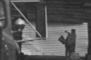
7 NPS Form a QMB No (3-82 > Expires United States Department of the Interior National Park Service National Register of Historic Places Inventory Nomination Form Continuation sheet Gully Homestead Item number 8 Page 2 During the time the Gullys owned the house, it was a center for family and community activity. Thomas had a moderately successful ranching operation. John is remembered for selling horses to delivery companies in the Denver area. While the farm fell on hard times after John's death, the children managed to keep it by ranching and running a rodeo from the 1920s through the 1950s. Both of Mary O'Brien's sons lived at the farm at various times, and Elizabeth Mann came back to have her daughter Betty born in the house. After Elizabeth's death, Betty's uncles raised her. In addition to being a center for family activity, the house served as a polling place for elections for the Tollgate School District. At various times, John was president of the district and Elizabeth was his secretary. The Gully house stood vacant until 1978 when it was determined that the building sat on a 100-year flood plain and was directly in the path of a proposed runoff canal. The owners of the property at the time, Medema Homes, Inc., decided to give the building to the city of Aurora with the provision that it be moved to a new location. Later that year, the house and stable were moved to Heritage Park next to the Justice Center on East Alameda Drive. The house was relatively easy to move because of its size, and the mover used the I-beam and roller method on a flatbed truck. The house stood on a concrete foundation in Heritage Park for several years. Following the 1982 purchase of the Delaney (Bresnahan) Ranch by the City, it was decided to move the Gully house to a site on the southern edge of the Delaney ranch. 1 The move was completed in 1983 by the same mover used in Since that time, the house has been completely restored and plans may allow reconstruction of some of the corrals as part of a proposed Gully-Delaney natural and historical agricultural complex. The Gully house and stable are placed 150 feet from the Delaney buildings and are visually interjected as a separate complex. The Gully home and stables face south away from the Delaney house which faces west toward Chambers Road. The house could not have been placed further east because it would have violated the city floodplain. The Gully house has been restored to the earliest known date Overall, the majority of the original fabric of the structure is intact. In areas where the original material was not salvagable, samples were retained and used as models for the reconstruction. Some materials from more recent alterations, such as linoleum from the kitchen floor, were also retained. A 1985 survey of Aurora revealed that this home is the oldest dwelling within the city limits. Rapid development has all but eliminated the agricultural remains of Aurora. Only the Gully and Delaney properties survive as representatives of the agricultural heritage of Aurora. It was decided not to include the Delaney complex in this nomination because the main house, built in 1911, is not architecturally or historically significant, and because many of the outbuildings were moved onto the property during the 1940s.

8 NPS Form a (3-82) United States Department off the Interior National Park Service National Register of Historic Places Inventory Nomination Form 0MB No Expires Continuation sheet Gully Homestead Item number 9 Page Mehls, Steven F., Carol Drake, and James E. Fell, Jr. Aurora: Gateway to the Rockies. Evergreen, CO.: Cordillera Press, Steinel, Alvin T. History of Agriculture in Colorado. Fort Collins, CO.: Colorado State Agricultural College, 1926.

9 NFS Form a (3-82) United States Department of the Interior National Park Service National Register of Historic Places Inventory Nomination Form Continuation sheet 0MB No Expires n,, j A, Co., Colorado Gully Homestead, Arapahoe Item number 10 Page 2 Verbal Boundary Description (continued) Bighline Canal; thence northwesterly along the north side of the Highline Canal to the point of beginning (Pt. C). Boundary Justification The boundaries were drawn to include the homestead house and stable, and to allow for sufficient acreage identifying the resource as an agricultural property located in a rural setting. A natural boundary on the east and the road on the west correspond to boundaries of the property's original site. The Highline Canal forms a natural boundary to the south, and the northern boundary was drawn to exclude the Delaney (Bresnahan) property due to its lack of architectural and historical significance.


10 I*

11 Gully Homestead " - ( CP Arapahoe County, Colorado Photographer: Sally Pearce May 20, 1985 Negatives: Aurora History Center Gully House looking north


12

13 Gully Homestead " 2 <=P Arapahoe County, Colorado Photographer: Sally Pearce May 20, 1985 Negatives: Aurora History Center Gully House looking southwest

14

15 Gully Homestead 3of 4? Arapahoe County, Colorado Photographer: Sally Pearce August 13, 1985 Negatives: Aurora History Center Gully House looking east


16 X

17 Gully Homestead ' 14 of 9 Arapahoe County, Colorado Photographer: Sally Pearce Negatives: Aurora History Center August 13,1985 Gully House looking east


18 p i

19 Gully Homestead ^ Op q Arapahoe County, Colorado Photographer: Sally Pearce August 13, 1985 Negatives: Aurora History Center Wood shed, Gully Homestead, looking N


20 tft\t'w


21 Gully Homestead 6 of 1 Arapahoe County, Colorado Photographer: Unknown November, 1978 Negatives: Aurora History Center House being moved to Justice Center Looking East


22


23 Gully Homestead J of q Arapahoe County, Colorado Photographer: Virginia Steele April, 1981 House on foundation at Justice Center Looking east Negatives: Aurora History Center

24


25 Gully Homestead 8 of S Arapahoe County, Colorado Photographer: Unknown Date unknown by prior to 1978 Original site of homestead Negatives: Aurora History Center


26


27 Gully Homestead 9 of 9 Arapahoe County, Colorado Photographer: Sally Pearce May 20, 1985 Negatives: Aurora History Center Homestead House and Delaney Complex Looking southwest
NPS Form OMB No Exp Status occupied X unoccupied work in progress Accessible yes: restricted yes: unrestricted _5Lno
 NPS Form 10-900 OMB No. 1024-0018 Exp. 10-31-84 United States Department of the Interior National Park Service National Register of Historic Places Inventory Nomination Form See instructions in How to
3. Classification. 5. Location of Legal Description. 6. Representation in Existing Surveys
 N~~ Form 10.900 (382) OMB No. 10240018 Exp. 103164 United States Department of the Interior National Park Service National Register of Historic Places InventoryNomination Form See instructions in How to
National Register off Historic Places received NOV U 1985 Inventory Nomination Form date ante** DEC j 2 BBS
 NPS Form 10400 042) 0MB No. 1024-0018 Exp. 10-31-84 United States Department off the Interior National Park Service For NFS us* only National Register off Historic Places received NOV U 1985 Inventory
National Register of Historic Places received 9 Inventory Nomination Form date entered M/W 9 I9S
 NPS Form 10-900 0MB No. 1024-0018 (3-82) Exp. 10-31-84 For NPS use only National Register of Historic Places received 9 Inventory Nomination Form date entered M/W 9 I9S See instructions in How to Complete
Places state West Virginia code county Marion
 NPS Form 1W0 csaa, United States Department of the lnteria? National Park Service National Register of Historic Inventory-Nomination Form See instructions in How to Complete National Register Forms Type
TYPE ALL ENTRIES -- COMPLETE APPLICABLE SECTIONS. Elsenhower Memorial Chapel (unofficially)
") Form No 10-306 (Rev 10-74) UNlTEDSTATtS DEPARTMENT OK THt INTERIOR NATIONAL PARK SERVICE NATIONAL REGISTER OF HISTORIC PLACES INVENTORY - NOMINATION FORM FOR FEDERAL PROPERTIES SEE INSTRUCTIONS IN HOW
Form No 10-306 (Rev 10-74) UNlTEDSTATtS DEPARTMENT OK THt INTERIOR NATIONAL PARK SERVICE NATIONAL REGISTER OF HISTORIC PLACES INVENTORY - NOMINATION FORM FOR FEDERAL PROPERTIES SEE INSTRUCTIONS IN HOW
Maryland Historical Trust Inventory No. 15/6 Maryland Inventory of Historic Properties Form
 Inventory No. 15/6 Maryland Inventory of 1. Name of Property (indicate preferred name) historic Becraft Farm other 2. Location street and number 28500 Ridge Road not for publication city, town Mount Airy
Maryland Historical Trust Inventory No. PG: 86A-026 Maryland Inventory of Historic Properties Form
 Inventory No. PG: 86A-026 Maryland Inventory of 1. Name of Property (indicate preferred name) historic other 2. Location street and number 12811 Croom Road not for publication city, town Naylor vicinity
Maryland Historical Trust Inventory No Maryland Inventory of Historic Properties Form
 Inventory No. 15 28 Maryland Inventory of 1. of Property (indicate preferred name) historic Luther Moore Farm other 2. Location street and number 7201 Damascus Road not for publication city, town Gaithersburg
3. Classification -- Category Ownership Status Present Use
 United States Department of the Interior National Park Service?htbn~! Register of klkt~rk Places For HPS UM only received Inventory-Nomination Form date entered See instructions in How to Complete National
- - CITY. TOWN CONGRESSIONAL DISTRICT. Princeton, VICINITY OF. STATE CODE COUNTY CODE West Virginia 54 Mercer 055
 UNITtD S DEPAKTMkNT OF THE IN1 EKIOR NATIONAL PARK SERVICE NATIONAL REGISTER OF HISTORIC PLACES INVENTORY -- NOMINATION FORM NAME HISTORIC AND/OR COMMON SEE INSTRUCTIONS IN HOW TO COMPLETE NATIONAL REGISTER
 Page 1 Original Update HISTORICAL STRUCTURE FORM FLORIDA MASTER SITE FILE Consult Guide To Historical Structure Forms for detailed instructions Site # 8OR9844 Recorder # 26 Recorder Date 2/20/08 Site Name
National Register of Historic Places Inventory-Nomination Form. I. Name. 5. Location of Lesal Descri~tion
 United States Department of the Interior National Park Service National Register of Historic Places Inventory-Nomination Form See instructions in How to Complete National Register Forms Type all entries-complete
THE BARNACLE 3485 MAIN HIGHWAY
 THE BARNACLE 3485 MAIN HIGHWAY Designation Report City of Miami REPORT OF THE CITY OF MIAMI PLANNING AND ZONING DEPARTMENT TO THE HISTORIC AND ENVIRONMENTAL PRESERVATION BOARD ON THE POTENTIAL DESIGNATION
Langley Register of Historic Places Nomination Form
 FOR OFFICE USE ONLY Langley Register of Historic Places Nomination Form Received Type all entries 1. Name of Property Historic: Jacob Anthes Bunkhouse/Cookhouse And/or common: South Whidbey Historical
CJheck one original s ite moved date
 FHR-8-300 (11-78) United States Department off the Interior Heritage Conservation and Recreation Service National Register of Historic Places Inventory Nomination Form See instructions in How to Complete
Maryland Historical Trust Inventory No. PG: 86A-003 Maryland Inventory of Historic Properties Form
 Inventory No. PG: 86A-003 Maryland Inventory of 1. Name of Property (indicate preferred name) historic other 2. Location street and number 12005 Duley Station Road not for publication city, town Upper
SEE INSTRUCTIONS IN HOWTO COMPLETE NATIONAL REGISTER FORMS TYPE ALL ENTRIES - COMPLETE APPLICABLE SECTIONS NAME VICINITY OF CODE STATUS
 Form No. 10-300 ^ \Q- UNITED S DEPARTMENT OF THE INTERIOR NATIONAL PARK SERVICE NATIONAL REGISTER OF HISTORIC PLACES INVENTORY -- NOMINATION FORM SEE INSTRUCTIONS IN HOWTO COMPLETE NATIONAL REGISTER FORMS
Maryland Historical Trust Inventory No. PG: Maryland Inventory of Historic Properties Form
 Inventory No. PG: 62-012 Maryland Inventory of 1. Name of Property (indicate preferred name) historic other 2. Location street and number 11205 Old Baltimore Pike not for publication city, town Beltsville
Status occupied unoccupied work in progress Accessible yes: restricted _X-_ yes: unrestricted no. Jackson County Courthouse
 NPS Form 10-900 (3-82) OMB No. 1024-0018 Exp. 10-31-84 United States Department of the Interior National Park Service National Register of Historic Places Inventory Nomination Form See instructions in
Address 347 Whitney Street. East elevation, camera facing southwest.
 FORM B BUILDING Assessor s Number USGS Quad Area(s) Form Number MASSACHUSETTS HISTORICAL COMMISSION MASSACHUSETTS ARCHIVES BUILDING 220 MORRISSEY BOULEVARD BOSTON, MASSACHUSETTS 02125 Town Northborough
HISTORIC SITE FORM HISTORIC SITES INVENTORY
 HISTORIC SITE FORM HISTORIC SITES INVENTORY 1 IDENTIFICATION Name of Property: House at 569 Park Avenue PARK CITY MUNICIPAL CORPORATION (10-08) Address: 569 Park Avenue City, County: Park City, Summit
street & number: COUNTY ROUTE 3, HC-88, BOX 17 not for publication: N/A city/town: WHEELER vicinity: X state: WV county: WEBSTER code: 101 zip code:
 NPS Forn 10-900 OMB No. 10024-0018 (Oct. 1990) United States Department of the Interior National Park Service NATIONAL REGISTIR OF HISTORIC PLACES REGISTRATICN FCRX =========================================================---------=======
"The Stone House;" Parker Family Residence; Slosn, Richard, House. Route 50 approximately 314 mile east of Junction
 Form No. 10300 (Rev. 1074) UNITED STATES DEPARTMENT OF THE INTERIOR NATIONAL PARK SERVICE NATIONAL REGISTER OF HISTORIC PLACES INVENTORY NOMINATXON FORM @NAME HISTORIC SEE INSTRUCTIONS IN HOW TO COMPLETE
Maryland Historical Trust Inventory No. PG: 81B-008 Maryland Inventory of Historic Properties Form
 Maryland Historical Trust Inventory No. PG: 81B-008 Maryland Inventory of 1. Name of Property (indicate preferred name) historic other 2. Location Dyson Farmhouse (preferred) street and number 13010 Piscataway
Architectural Inventory Form
 OAHP1403 Rev. 9/98 COLORADO CULTURAL RESOURCE SURVEY Architectural Inventory Form Official eligibility determination (OAHP use only) Date Initials Determined Eligible- NR Determined Not Eligible- NR Determined
n/a vicinity of Status x occupied unoccupied work in progress Accessible x yes: restricted yes: unrestricted no
 NFS Form 10-900 (3-82) OMB No. 1024-0018 Exp. 10-31-84 United States Department of the Interior National Park Service National Register of Historic Places Inventory Nomination Form See instructions in
Maryland Historical Trust Inventory No. PG: 75A-007 Maryland Inventory of Historic Properties Form
 Inventory No. PG: 75A-007 Maryland Inventory of 1. Name of Property (indicate preferred name) historic other 2. Location street and number 3101 Ritchie Road not for publication city, town Forestville vicinity
National Register off Historic Places Inventory Nomination Form
 MPS Fonn 10-900-a (3^ United States Department of the Interior National Park Service National Register off Historic Places Inventory Nomination Form For NPS use only received date entered OMB No 1M4-0018
THE CORPORATION OF THE TOWN OF NIAGARA-ON-THE-LAKE. BY-LAW NO (214 Four Mile Creek Road)
") THE CORPORATION OF THE TOWN OF NIAGARA-ON-THE-LAKE BY-LAW NO. 4807-15 (214 Four Mile Creek Road) A BY-LAW TO DESIGNATE THE PROPERTY KNOWN MUNICIPALLY AS WOODBOURNE, 214 FOUR MILE CREEK ROAD, IN THE TOWN
THE CORPORATION OF THE TOWN OF NIAGARA-ON-THE-LAKE BY-LAW NO. 4807-15 (214 Four Mile Creek Road) A BY-LAW TO DESIGNATE THE PROPERTY KNOWN MUNICIPALLY AS WOODBOURNE, 214 FOUR MILE CREEK ROAD, IN THE TOWN
Commonwealth of Massachusetts Massachusetts Historical Commission 220 Morrissey Boulevard, Boston, Massachusetts
 Inventory No: Historic Name: Common Name: Address: HRV.165 Blood, Joseph House Farnsworth, Jonathan - Beaman, Jonathan House 74 Poor Farm Rd City/Town: Village/Neighborhood: Local No: 9-17 Year Constructed:
6. Representation in Existing Surveys. National Register of Historic Places Inventory Nomination Form. 1. Name. 4. Owner of Property !
 NPS Form 10-900 (3-82) OMB No. 1024-0018 Exp. 10-31-84 United States Department of the Interior National Register of Historic Places See instructions in How to Complete National Register Forms Type all
National Register off Historic Places Inventory Nomination Form
 NPS Fomi ia-900-a OMB Ho. 1024-0018 Exp. 10-31-S4 United States Department of the Interior National Park Service National Register off Historic Places Inventory Nomination Form For HPS UM only received
NE¼ of NE¼ of NE¼ of NE¼ of section Roof configuration (enter one): Gabled Roof / Front Gabled Roof
: Gabled Roof / Front Gabled Roof") OAHP1403 Rev. 9/98 COLORADO CULTURAL RESOURCE SURVEY Official Eligibility Determination (OAHP use only) Date Initials Determined Eligible - National Register Architectural Inventory Form Determined Not
OAHP1403 Rev. 9/98 COLORADO CULTURAL RESOURCE SURVEY Official Eligibility Determination (OAHP use only) Date Initials Determined Eligible - National Register Architectural Inventory Form Determined Not
Status XX occupied unoccupied work in progress Accessible XX yes: restricted yes: unrestricted no. Zorn Farms, Inc., and Henry Zorn Estate
 FHR-8-300 (11-78) United States Department of the Interior Heritage Conservation and Recreation Service National Register of Historic Inventory Nomination Form See instructions in How to Complete National
; * --.-.,., rj ; United States Department of the Interior \ ' '"] I National Park Service
![; * --.-.,., rj ; United States Department of the Interior \ ' '] I National Park Service](/thumbs/88/117765392.jpg "; * --.-.,., rj ; United States Department of the Interior \ ' '] I National Park Service") NPS Form 10-900 OMB No. 1024-0018 (Rev. 10-90) : / i' -_ :. - : ; ; * --.-.,., rj ; United States Department of the Interior \ ' '"] I National Park Service NATIONAL REGISTER OF HISTORIC PLACES REGISTRATION
NPS Form 10-900 OMB No. 1024-0018 (Rev. 10-90) : / i' -_ :. - : ; ; * --.-.,., rj ; United States Department of the Interior \ ' '"] I National Park Service NATIONAL REGISTER OF HISTORIC PLACES REGISTRATION
State Level Historic Documentation Report. John Blue Bridge Hampshire County
 State Level Historic Documentation Report State Project No. S314-28-22.27 Federal Project No. BR-0028(058)D John Blue Bridge Hampshire County Prepared by: Randy Epperly, Historian Department of Transportation
DESIGNATION REPORT KENNEDY-BAKER-WALKER-SHERRILL HOUSE (1849) 9320 KINGSTON PIKE (CLT ) KNOXVILLE, TENNESSEE July 12, 2007
 9320 KINGSTON PIKE (CLT ) KNOXVILLE, TENNESSEE July 12, 2007") DESIGNATION REPORT KENNEDY-BAKER-WALKER-SHERRILL HOUSE (1849) 9320 KINGSTON PIKE (CLT 132-027) KNOXVILLE, TENNESSEE July 12, 2007 Description The Kennedy-Baker-Walker-Sherrill House is located on the south
DESIGNATION REPORT KENNEDY-BAKER-WALKER-SHERRILL HOUSE (1849) 9320 KINGSTON PIKE (CLT 132-027) KNOXVILLE, TENNESSEE July 12, 2007 Description The Kennedy-Baker-Walker-Sherrill House is located on the south
National Register of Historic Places Registration Form
 NPS Form 10-900 OMB No. 1024-0018 (Rev. 10-90) United States Department of the Interior National Park Service National Register of Historic Places Registration Form 1. Name of Property historic name Newcomer
FLAGLER WORKER S HOUSE FORT DALLAS PARK S.E. 4 STREET
 FLAGLER WORKER S HOUSE FORT DALLAS PARK 60-64 S.E. 4 STREET Designation Report City of Miami REPORT OF THE CITY OF MIAMI PLANNING DEPARTMENT TO THE HERITAGE CONSERVATION BOARD ON THE POTENTIAL DESIGNATION
MINNESOTA HISTORIC.PROPERTIES INVENTORY FORM. Yes_ No X Restricted
 HISTORIC NAME: CURRENT NAME: LEGAL DESC.: MINNESOTA HISTORIC.PROPERTIES INVENTORY FORM Hartley Sugar Camp W % of Gov't. Lot 3 and T55, R24, Sec. 9 COUNTY: Itasca CITY/TWP.: Trout Lake Twp. ADDRESS: of
United States Department of the Interior National Park Service. Boundary Expansion Listed in National Register January 11, 2017
 NPS Form 10900-a (Rev. 8/2002) OMB No. 10240018 United States Department of the Interior National Park Service Boundary Expansion Listed in National Register January 11, 2017 National Register of Historic
NPS Form (3-82) OMB No Expires
 OMB No Expires") NPS Form 10-900 (3-82) OMB No. 1024-0018 Expires 10-31-87 United States Department of the Interior National Park Service National Register of Historic Places Inventory Nomination Form See instructions
NPS Form 10-900 (3-82) OMB No. 1024-0018 Expires 10-31-87 United States Department of the Interior National Park Service National Register of Historic Places Inventory Nomination Form See instructions
- vicinity of. Status. Present Use. occupied agriculture A!- museum t -L structure - both - work in progress - educational private residence
 Unitad States Department of the Interior - National Park Service - ational Register of Historic Places -- - inventory-nomination Form See instructions in How to Complete National Register Forms Type all
about 1% miles south of Lahmansville STATE CODE COUNTY CODE West Virginia 5 4 Grant 023 X_OCCUPIED -BEING CONSIDERED -YES: UNRESTRICTED -NO
 Furm No. 10300 (Rev. 10.74) UNITED S DLPARTXIENT OF TIIE INTERIOR NATIONAL PARK SERVICE NATIaNAE REGISTER OF HSTORIC I? LACES INVENTORY NCIMINATICIET FORM I/Lkmm w NAME SEE INSTRUCTIONS IN HOW TO COMPLETE
NATIONAL REGISTER OF HISTORIC PLACES REGISTRATION FORM
 NPS Form 10-900 OMB No. 1024-0018 (Rev. 10-90) United States Department of the Interior National Park Service NATIONAL REGISTER OF HISTORIC PLACES REGISTRATION FORM 1. Name of Property historic name Compton-Johnson
NPS Form OMB No (Oct. 1990)
") NPS Form 10-900 OMB No. 10024-0018 (Oct. 1990) United States Department of the Interior National Park Service NATIONAL REGISTER OF HISTORIC PLACES REGISTRATION FORM 1. Name of Property historic name:_lost
NPS Form 10-900 OMB No. 10024-0018 (Oct. 1990) United States Department of the Interior National Park Service NATIONAL REGISTER OF HISTORIC PLACES REGISTRATION FORM 1. Name of Property historic name:_lost
First Floor Plan. Second Floor Plan
 The Flint Homestead was built by 1709 for Ephraim Flint (1641 1723) and his wife Jane Bulkeley. They did not have any children. In 1723 he willed his mansion house to his nephew, John Flint, and to John
National Register off Historic Places Inventory Nomination Form
 NPS Fomi 10-900 a OMB Mo. 1024-0018 Exp. 10-31-64 United States Department of the interior National Park Service National Register off Historic Places Inventory Nomination Form For NPS use only received
National Register of Historic Places Inventory Nomination Form
 NPS Form 10-900-a Exp. 10-31-84 Continuation sheet 4 5 item number 7 Page 45 NAME: Knight Estate LOCATION: 486 East Avenue,,--v..u^-^ OWNER: State of Rhode Island Department of Education Board of Regents
Town: Sharon Place (neighborhood or village): Sharon. ame of Area: Present Use: Date (month / year): July 2008
: Sharon. ame of Area: Present Use: Date (month / year): July 2008") FORM A - AREA MASSACHUSETTS HISTORICAL COMMISSION MASSACHUSETTS ARCHIVES BUILDING 220 MORRISSEY BOULEVARD BOSTON, MASSACHUSETTS 02125 Photograph Assessor s Sheets USGS Quad Area Letter Form Numbers in
FORM A - AREA MASSACHUSETTS HISTORICAL COMMISSION MASSACHUSETTS ARCHIVES BUILDING 220 MORRISSEY BOULEVARD BOSTON, MASSACHUSETTS 02125 Photograph Assessor s Sheets USGS Quad Area Letter Form Numbers in
SEE INSTRUCTIONS IN HOWTO COMPLETE NATIONAL REGISTER FORMS TYPE ALL ENTRIES - COMPLETE APPLICABLE SECTIONS NAME VICINITY OF CODE STATUS
 Form No. 10-300, \Q-1 \&V UNITED STATES DEPARTMENT OF THE INTERIOR INVENTORY - NOMINATION FORM SEE INSTRUCTIONS IN HOWTO COMPLETE NATIONAL REGISTER FORMS TYPE ALL ENTRIES - COMPLETE APPLICABLE SECTIONS
OR THEMATIC NOMINATION. STREET & NUMBER W side of SR l48s, 1.S mil. N of Muddy Creek _N()T FOR PUBLICATION CITY, TOWN. CONGRESSIONAL DISTRICT Arcadia
T FOR PUBLICATION CITY, TOWN. CONGRESSIONAL DISTRICT Arcadia") _--..,""'-"-_""-""- COUNTY xx::.c...- MULTIPLE RESOURCE OR THEMATIC NOMINATION HISTORIC Hampton House STREET & NUMBER W side of SR l48s, 1.S mil. N of Muddy Creek _N()T FOR PUBLICATION CITY, TOWN CONGRESSIONAL
_--..,""'-"-_""-""- COUNTY xx::.c...- MULTIPLE RESOURCE OR THEMATIC NOMINATION HISTORIC Hampton House STREET & NUMBER W side of SR l48s, 1.S mil. N of Muddy Creek _N()T FOR PUBLICATION CITY, TOWN CONGRESSIONAL
Hwy Retaining Wall/ Sea Wall. Not Eligible, see Statement of Significance Also member of listed NR district: Mantorville Historic District
 Historic Name CS # 2007 Other Name SHPO Inv # Location E and W sides of TH 57 between 6th St and 7th St Hwy District Reference City/Township County Mantorville, City of Dodge Acres Twp Rng Sec 107N 16W
ate: AR County: Pulaski Code: AR Zip Code: Noncontributing buildings sites structures objects Total
 Mims-Ereedlove-Priest-Weatherton House Name of Property Little Rock, AR County and State ~- -,s Form 10-900 'V. 8-86) OMB No. 1024-0018 United States Department of the Interior National Park Service NATIONAL
Society Member to Supervise the Building of James Monroe s Birthplace House Charles Belfield, a councilor of the War of 1812 Society in the
 Society Member to Supervise the Building of James Monroe s Birthplace House Charles Belfield, a councilor of the War of 1812 Society in the Commonwealth of Virginia has been designated as the supervisor
CHRONOLOGY & DEVELOPMENT BOUDINOT-SOUTHARD PROPERTY BASKING RIDGE, NJ OF THE
 CHRONOLOGY & DEVELOPMENT OF THE BOUDINOT-SOUTHARD PROPERTY BASKING RIDGE, NJ Elias Boudinot 1740 Elias Boudinot born May 2 in Philadelphia, where his family was a neighbor of Benjamin Franklin. 1760 Boudinot
United States Department of the Interior National Park Service NATIONAL REGISTER OF HISTORIC PLACES REGISTRATION FORM
 NPS Form 10-900 (Rev. 8-86) OMB No. 1024-0018 United States Department of the Interior National Park Service NATIONAL REGISTER OF HISTORIC PLACES REGISTRATION FORM other name/site number: "Maple Shadows:"
Current Functions (Enter categories from instructions) Materials (Enter categories from instructions)
 Materials (Enter categories from instructions)") Site Inventory Form State Inventory No. 92-00542 New Supplemental State Historical Society of Iowa Part of a district with known boundaries (enter inventory no.) 92-00349 (November 2005) Relationship:
Site Inventory Form State Inventory No. 92-00542 New Supplemental State Historical Society of Iowa Part of a district with known boundaries (enter inventory no.) 92-00349 (November 2005) Relationship:
AH pp. I Ti. Nov 7 I) I I y
 I I y") ..------------------------------------------ ------------ - - -- - NPS Form 10-900 (Rev. 8-86) United States Department of the Interior ~a tional Park Service NATIONAL REGISTER OF HISTORIC PLACES REGISTRATION
..------------------------------------------ ------------ - - -- - NPS Form 10-900 (Rev. 8-86) United States Department of the Interior ~a tional Park Service NATIONAL REGISTER OF HISTORIC PLACES REGISTRATION
1 Gildersleeve Wood (DHR # )
") GILDERSLEEVE WOOD 1 Gildersleeve Wood (DHR # 104-5092-0012) STREET ADDRESS: 1 Gildersleeve Wood MAP & PARCEL: 11-20 PRESENT ZONING: R-1U ORIGINAL OWNER: Lindsay Family ORIGINAL USE: PRESENT USE: PRESENT
GILDERSLEEVE WOOD 1 Gildersleeve Wood (DHR # 104-5092-0012) STREET ADDRESS: 1 Gildersleeve Wood MAP & PARCEL: 11-20 PRESENT ZONING: R-1U ORIGINAL OWNER: Lindsay Family ORIGINAL USE: PRESENT USE: PRESENT
National Register of Historic Places Inventory Nomination Form
 NPS Fom 10-900-a (M2) United States Department off the Interior National Park Service National Register of Historic Places Inventory Nomination Form For HPS use received date entered 6^ OMB No. 1024-0018
1 buildings sites structures objects 1 0 TOTAL
 Name of Property County and State 4. National Park Service Certification --------- I, hereby certify that this property is: Signature of Keeper Date of Action entered in the National Register See continuation
AHPP. LISTED ========================================================================
 NPS Form 10-900 (Rev. 8-86) Jnited States Department of the Interior ational Park Service OMB No. 1024-0018 LISTED NATIONAL REGISTER OF HISTORIC PLACES REGISTRATION FORM AHPP. 1. Historic Name: Bush-Dubisson
National Register of Historic Places Registration Form
 NPS Form 10-900 OMB No. 10024-0018 (Oct. 1990) United States Department of the Interior National Park Service National Register of Historic Places Registration Form 1. Name of Property historic name Hickory
Fletchertown (71A-022)
") Fletchertown (71A-022) Fletchertown is a late-nineteenth-century rural African-American community in northeastern Prince George s County. The community is located south of Huntington and northwest of Bowie.
Fletchertown (71A-022) Fletchertown is a late-nineteenth-century rural African-American community in northeastern Prince George s County. The community is located south of Huntington and northwest of Bowie.
National Register of Historic Places Registration Form
 NPS Form 10-900 OMB No. 1024-0018 (Rev. 10-90) United States Department of the Interior National Park Service National Register of Historic Places Registration Form 1. Name of Property historic name Strode-Morrison-Tabler
Appendix D Reevaluation of Structures on Bock House Property
 Appendix D Reevaluation of Structures on Bock House Property Page 1 Original Update HISTORICAL STRUCTURE FORM FLORIDA MASTER SITE FILE Consult Guide To Historical Structure Forms for detailed instructions
301 7½ Street SW
 301 7½ Street SW 104-0213-0072 Primary Resource Information: Single Dwelling, Stories 2.00, Style: Other, ca 1890 July 2006: This late-19th-century, 3-bay, 2-story, hip-roofed frame I-house features projecting
United States Department of the Interior National Park Service NATIONAL REGISTER OF HISTORIC PLACES REGISTRATION FORM
 NPS Form 10-900 (Oct. 1990) OMB NO. 10024-0018 United States Department of the Interior National Park Service NATIONAL REGISTER OF HISTORIC PLACES REGISTRATION FORM As the designated authority under the
History/Descriptive Notes: 3.5 acres with orchard that was actively used until current owner purchased in 1982.
 Address: 4395 McCandlish Road Tax Parcel Number: 12-22-200-031 Year Built: 1926 (per owner) Architectural Style: Craftsman Other Buildings/Features: garage (date unknown) 61 History/Descriptive Notes:
MEDIA ADVISORY. FOR IMMEDIATE RELEASE November 12, 2012
 MEDIA ADVISORY FOR IMMEDIATE RELEASE November 12, 2012 Niagara-on-the-Lake On Monday, November 19, 2012, the Lord Mayor and members of the Town s Municipal Heritage Committee and War of 1812 Bicentennial
HENNIGAN PLACE. This photograph is circa November Name, address, and telephone number of the present owner and occupant of the property:
 HENNIGAN PLACE This report was written on November 7, 1979 This photograph is circa November 2006. 1. Name and location of the property: The property known as the Hennigan Place is located at 3503 Tilley
MID-ATLANTIC HISTORIC BUILDINGS AND LANDSCAPE SURVEY. Polk-Atkinson House Appoquinimink Hundred New Castle County, Delaware
 MID-ATLANTIC HISTORIC BUILDINGS AND LANDSCAPE SURVEY Polk-Atkinson House Appoquinimink Hundred New Castle County, Delaware Center for Historic Architecture and Design Newark, Delaware 197 16 2005 MID-ATLANTIC
N/A not for publication city or town : Hillsboro - X vicinity state: West Virginia code: WV countv: Pocahontas code: 075 zip code: 24946
 United States Department of the Interior National Park Service historic name : other nameslsite number : NIA. -.- 2. Location street & number : HC 64. Box 147loff County Road 3 1 on Kyle Beard Road N/A
Status X occupied unoccupied X work in progress Accessible X yes: restricted - yes: unrestricted np. Clackamas County Courthouse.
 NFS Form 10-900 (3-82) United States Department of the Interior National Park Service National Register of Historic Places Inventory Nomination Form See instructions in How to Complete National Register
Commonwealth of Massachusetts Massachusetts Historical Commission 220 Morrissey Boulevard, Boston, Massachusetts
 Inventory No: Historic Name: Common Name: Address: HRV.173 Rand, Jonathan House and Farm Taylor, William Jr. - Barnard, Ephraim House 44 Littleton County Rd City/Town: Village/Neighborhood: Local No: 23-20,21
COLORADO HISTORICAL SOCIETY COLORADO STATE REGISTER OF HISTORIC PROPERTIES NOMINATION FORM
 COLORADO HISTORICAL SOCIETY COLORADO STATE REGISTER OF HISTORIC PROPERTIES NOMINATION FORM OAHP1414 (Rev. 8/2003) SECTION I Name of Property Historic Name Other Names HUBBARD RANCH / TEN SLEEP RANCH /
- district. - site. sites structures abiects TOTAL. Number of contributing resources previously listed in the National Register None
 Brown, Colonel Thomas House Name of Property Preston County, WV County and State 5. Classification Ownership of Property: (Check as many boxes as apply) X private - public-local - public-state - public-federal
Maryland Historical Trust Inventory No. PG: 74B-030 Maryland Inventory of Historic Properties Form
 Inventory No. PG: 74B-030 Maryland Inventory of 1. Name of Property (indicate preferred name) historic other 2. Location street and number city, town county 15504 Hall Road Bowie Prince George's not for
Crown Lands and Property Agency. Name Client # LAST (Please Print) FIRST MIDDLE (no initials) Mailing Address. Postal Code
 FIRST MIDDLE (no initials) Mailing Address. Postal Code") Manitoba Conservation and Water Stewardship Application for Permit/Lease/Purchase/Easement/Exchange/Licence of Occupation (under The Crown Lands Act c.c340) Please check one ( ) Permit Lease Purchase Easement
Manitoba Conservation and Water Stewardship Application for Permit/Lease/Purchase/Easement/Exchange/Licence of Occupation (under The Crown Lands Act c.c340) Please check one ( ) Permit Lease Purchase Easement
Change dormers and main entry on the river side of the house. Site: 43 Riverbank Road, Block 10 Lot 3
 City of Burlington Historic Preservation Commission Meeting Minutes: December 2, 2015 The City of Burlington Historic Preservation Commission held its regular monthly meeting on Wednesday, December 2,
MASSACHUSETTSHISTORICAL COMMISSION Office of the Secretary, State House, Boston. 1. Town Marlborough. Name Josiah Stow Homestead.
 FORM B - BUILDING In Area no. Form no. MASSACHUSETTSHISTORICAL COMMISSION Office of the Secretary, State House, Boston / ;;L. 1. Town Address Spoonhill Ave. Name Josiah Stow Homestead 2. Present use Residence
Total 1 Total. Current Functions (Enter categories from instructions) Materials (Enter categories from instructions)
 Materials (Enter categories from instructions)") Site Inventory Form State Inventory No. 29-00962 New Supplemental State Historical Society of Iowa Part of a district with known boundaries (enter inventory no.) 29-03685 (November 2005) Relationship:
Site Inventory Form State Inventory No. 29-00962 New Supplemental State Historical Society of Iowa Part of a district with known boundaries (enter inventory no.) 29-03685 (November 2005) Relationship:
National Register of Historic Places Inventory-Nomination Form. 3. Classification. 5. Location of Legal Description. 1. Name. 4.
 OM8 Ha. 1024-0018 EXP. 10-31-64 United States Department of the Interior National Park Service National Register of Historic Places See instructions in How to Complete National Register Forms Type all
National Register of Historic Places Registration Form
 NPS Form 10-900 OMB No. 10024-0018 (Oct. 1990) Registration Form This form is for use in nominating or requesting determinations for individual properties and districts. See instructions in How to Complete
The George Rieley home place, built 1852, from bricks molded and baked on the premises.
 The George Rieley home place, built 1852, from bricks molded and baked on the premises. 1. SUBJECT: Old Riley [sic] Place. 2. LOCATION: 1/16 mile east of Blue Ridge Va. on Route /460. House on north side
STATE CODE COUNTY CODE West Virginia 54 Greenbrier 025 STATUS ZOCCUPIED -UNOCCUPIED -WORK IN PROGRESS ACCESSIBLE YES: RESTRICTED
 "orm No. 10300 (Rev. 10741., US1TED STlITES DEPARTMENT OF THE INTERIOR NATIONAL PARK SERVICE FOR NPS USE ONLY NATIONAL REGISTER OF HISTORIC PLACES RECEtVEQ,/, INVENTORY NOMINATION FORM,., d' >A; 4y.. y
Cranberry Lake Farm. By Alicia McCullough for the Oakland Township HDC
 Cranberry Lake Farm By Alicia McCullough for the Oakland Township HDC Cranberry Lake Farm s History Cranberry Lake Farm was purchased by Seymour Fletcher in 1837 from the Federal Government. The development
National Register of Historic Places Registration Form
 NPS Form 10-900 OMB No. 10024-0018 (Oct. 1990) United States Department of the Interior National Park Service National Register of Historic Places Registration Form 1. Name of Property historic name other
SEE INSTRUCTIONS IN HOWTO COMPLETE NATIONAL REGISTER FORMS TYPE ALL ENTRIES - COMPLETE APPLICABLE SECTIONS
 Form No. 10-300 (Rev. 10-74) ^^ UNITEDSTATESDEPARTIvBrr OF THE INTERIOR INVENTORY - NOMINATION FORM SEE INSTRUCTIONS IN HOWTO COMPLETE NATIONAL REGISTER FORMS TYPE ALL ENTRIES - COMPLETE APPLICABLE SECTIONS
ATTACHMENT C ARLINGTON COUNTY REGISTER OF HISTORIC PLACES HISTORIC DISTRICT DESIGNATION FORM
 1. NAME OF PROPERTY ARLINGTON COUNTY REGISTER OF HISTORIC PLACES HISTORIC DISTRICT DESIGNATION FORM Historic Name: Other names: Reevesland Torreyson Farm 2. LOCATION OF PROPERTY Street and Number: 400
Appendix E Historic Property Inventory Forms
 Appendix E Historic Property Inventory Forms TECHNICAL MEMORANDUM Sound Transit Federal Way Link Extension WISAARD Survey Entries PREPARED FOR: COPY TO: PREPARED BY: Sound Transit Alisa Swank/ CH2M MaryNell
NPS Form b OMB No United States Department of the Interior National Park Service
 United s Department of the Interior El Camino Real de Tierra Adentro in, AD 1598-1881 El Camino Real de Tierra Adentro in, AD 1598-1881 (Additional Documentation) The purpose of this additional documentation
Abandoned or Vacant; Agricultural; Camp; Other Residential Agriculture; Archaeology, Historic; Architecture; Politics Government; Social History
 Inventory No: Historic Name: HRV.G Civilian Conservation Camp Common Name: Address: City/Town: Village/Neighborhood: Local No: 13-7.01 Year Constructed: Architect(s): Architectural Style(s): Use(s): Significance:
Maryland Historical Trust Inventory No Maryland Inventory of Historic Properties Form
 Inventory No. 15-71 Maryland Inventory of 1. Name of Property (indicate preferred name) historic other 2. Location Chrobot House Margaret Price House street and number 24724 Hipsley Mill Road not for publication
National Register of Historic Places Continuation Sheet
 Section number N/A Page 1 Proposed Amendment to Wichita, Sedgwick County, Kansas The owner of the building at 141 S. Rock Island Avenue requests amendment to the boundaries of the East Douglas Historic
Late-nineteenth-century view of the Macy house on Liberty Street GPN2044. Nantucket Historical Association
 MACY-CHRISTIAN OLDEST HOUSE HOUSE Late-nineteenth-century view of the Macy house on Liberty Street GPN2044 10 Nantucket Historical Association MACY-CHRISTIAN» OLDEST HOUSE Macy-Christian House In the early
L 2-1. Heritage Report: Reasons for Heritage Designation. Wilkinson / Lundy Farmhouse 715 Queen Street West
 L 2-1 Heritage Report: Reasons for Heritage Designation Brampton Heritage Board Date: January 15, 2013 Wilkinson / Lundy Farmhouse 715 Queen Street West January 2013 1 L 2-2 Profile of Subject Property
United States Department of the Interior National Park Service NATIONAL REGISTER OF HISTORIC PLACES REGISTRATION FORM. Wilmoth, Bernard E.
 NPS Form 10-900 OMB No. 10024-0018 (Oct. 1990) United States Department of the Interior National Park Service NATIONAL REGISTER OF HISTORIC PLACES REGISTRATION FORM 1. Name of Property historic name: other