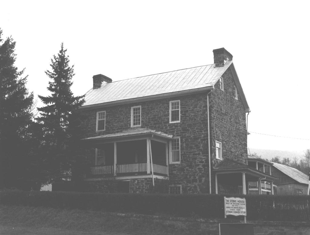
"The Stone House;" Parker Family Residence; Slosn, Richard, House. Route 50 approximately 314 mile east of Junction
|
|
|
- Norma Johnson
- 6 years ago
- Views:
Transcription
1 Form No (Rev. 1074) UNITED STATES DEPARTMENT OF THE INTERIOR NATIONAL PARK SERVICE NATIONAL REGISTER OF HISTORIC PLACES INVENTORY NOMINATXON HISTORIC SEE INSTRUCTIONS IN HOW TO COMPLETE NATIONAL REGISTER FORMS TYPE ALL ENTRIES COMPLETE APPLICABLE SECTIONS "The Stone House;" Parker Family Residence; Slosn, Richard, House AND/OR COMMON "The Stone House" STREET~NUMBER Along U.S. Route 50 approximately 314 mile east of Junction Junction.& VICINITY OF Second NOT FOR PUBLICATION CONGRESSIONAL DISTRICT STATE CODE COUNTY CODE West Virginia 54 Hampshire 027 ECLASSIFICATION L CATEGORY OWNERSHIP STATUS DISTRICT PUBLIC XOCCUPED XBUILDING~S) EPRIVATE UNOCCUPIED STRUCTURE BOTH WORK IN PROGRESS SITE PUBLIC ACQUISITION ACCESSIBLE OBJECT IN PROCESS ZYES: RESTRICTED BEING CONSIDERED YES: UNRESTRICTED NO PRESENT USE AGRICULTURE MUSEUM COMMERCIAL PARK EDUCATIONAL XPRIVATE RESIDENCE ENTERTAINMENT RELIGIOUS GOVERNMENT SCIENTIFIC INDUSTRIAL TRANSPORTATION MILITARY OTHER: NAME Mr. and Mrs. John Henry Parker, Jr. STREET & NUMBER Box 454 STATE Romney VICINITY OF West Virginia ELOCATION OF LEGAL DESCRIPTION COURTHOUSE. REGISTRY OF DEEDS.FIC STREET 6 NUMBER CITY TOWN Hampshire County Courthouse Main and High Streets Romney REPRESENTATION IN EXISTING SURVEYS TITLE STATE West Virginia. DATE DEPOSITORY FOR SURVEY RECORDS FEDERY STATE COUNM LOCAL STATE
2 B DESCRIPTION CONDITION CHECK ONE CHECK ONE EXCELLENT DETERIORATED UNALTERED?ORIGINAL SITE XGOOD RUINS x~~~~~~~ MOVED DATE FAIR UNEXPOSED DESCRIBE THE PRESENT AND ORIGINAL (IF KNOWN) PHYSICAL APPEARANCE "The Stone House" near Junction, Hampshire County, West Virginia, presently consists of the c stone section facing U.S. Route 50 and a c frame section which forms the leg of the "T"shaped structure. The stone part is basically unchanged since con. struction, but minor alterations were made when the frame part was added. Little alteration has been done on the latter. The field stone front is rectangular in shape (approximately 45 feet long and 40 feet deep) with symmetry of design inherent (with minor exceptions in the basement). The corth (front) elevation has three openings on first and second floors and one window in the west room of the basement. As throughout the stone section, secondfloor windows are 619, doublehung sash while those on the first level are 911 (originally 9/9). Basement windows consist of two sliding panels each with 4/4pane design. A high stone platform reaches to the level of the first floor on this elevation and supports a balustered porch. The front door has vertical boards on the outside with horizontal boards on the interior, and both it and the old back door (which leads into the frame area) have a foursectioned, rectangular overlight. East and west elevations are similar in design, but the west has a low door in the basement with exterior porch and a small window toward the front of the first floor which was added after the frame addition was placed. The east had a door and small porch put on the north of the first floor about Both east and west sides house an interior chimney (brick has replaced stoneat the tops) with small, 214 windows to either side of it in the attic. The south (rear) elevation of the stone part is still intact as the north wall of the frame section, but a secondfloor window has been removed from the center to provide an opening to the rear and the old back door serves as entrance to the first floor of this area. The frame section has numerous windows and doors of various sizes and styles; A deep porchcompletelyencircles this part on the east and southand reaches to a threesided bay which has been placed on its west elevation. The frame area is covered with wooden shingles, and the entire house has a metal roof; On the interior, the addition houses dining room, kitchen, bath and sleeping areas. The old stone part contains two rooms on each floor. In the basement of the latter is the old kitchen and dining section on the west side. This includes a large fireplace, and the walls are about thirtysix inches thick (they taper to about" twelve inches in the attic). On the east side is a storage area. The first floor used to have bedrooms, but this is now used for living and sitting rooms. On this level only the east side originally had a fireplace (it was changed in design about 1915), but one has been opened in the west room during the twentieth century. The second floor contains two bedrooms, each with fireplace. The attic is open from east to west, and rafters (tied together with wooden pegs) still show markings of a series of letters and numbers which aided in correct placement of members when they were raised from the ground during construction. Most of the flooring in the stone section is original, as is much of the hardware on the doors. There are presently several barns and storage areas on the property, including an old log smokehouse, but the most interesting is a large barn built in It has widely spaced, unhewn logs on the interior and south side, and the remainder is enclosed in wooden framing.
3 PERIOD PREHISTORIC xi 800 I ass 1900 AREAS OF SIGNIFICANCE CHECK AND JUSTlFf BELOW ARCHEOLOGYPREHISTORIC COMMUNIM PUNNING LANDSCAPE ARCHITECTURE RELIGION ARCHEOLOGYHISTORIC CONSERVATION, LAW SCIENCE AGRICULTURE ECONOMICS LITERATURE SCULPTURE ZARCHITECTURE EDUCATION XMILITARY SOCIAUHUMANITARIAN A R T ENGINEERING MUSIC THEATER COMMERCE EXPLORATION/SETTLEMENT PHILOSOPHY STRANSPORTAT COMMUNICATIONS 51 NOUSTRY POLITICS/GOVERNMENT OTHER (SPECIFY) J NVENTION SPECIFIC DATES c, 1790 BUILDER/ARCHITECT STATEMENT OF SIGNIFICANCE "The Stone House," a large and finely built structure, was erected for Richard Sloan about He and his wife had decided to settle in Hampshire County, Virginia, and soon developed a family weaving industry centered around their lands just west of the county seat at Romney. The trade in woolens and linens must have been satisfactory locally, for the family of twelve continued in the business until near the middle of the nineteenth century before selling the property to three Parker brothers in Henceforth, the stone structure would be the center of a farm, but it would also see uses as a stage stop and polling place as well as become a source of goods for Federal troops who passed by during the Civil War. Richard Sloan had come to the United States shortly after the Revolutionary War from Ireland where his family had settled after leaving Scotland. He was at first indentured to a David Van Horn in Philadelphia in order to work off payment of his passage, but he soon ran away with Charlotte, daughter of Van Horn. After marriage and a short stay in Baltimore, the Sloans moved on to Romney in Hampshire County, Virginia, and constructed the house which still stands as evidence of a wellbuilt country dwelling of the day and place. Their home was made of locally available materials and must have been quite large for the time. The approximately 40 feet by 45 feet structure was interestingly designed so as to taper in the wall from a nearly 36 inch thickness at rhe base to only 12 inches at the top. The basement and both main floors each had two rooms, and the attic was an open and usable area. The great size of the house was fortunate for Richard and Charlotte, for it could provide sufficient space for their ten children (six boys and four girls) and room to accommodate the many steps in the production of woven goods. Until they were able to erect a separate loom house, the entire process was accomplished in the structure. The family probably raised their own sheep and grew some flax or obtained the raw wool and flax from nearby residents. Most of their products were sold locally, and the present occupants retain several coverlets of fine quality and design which were produced by the Sloans. Tradition in the family maintains that only James, youngest son of Richard and Charlotte, married. He was chosen for this because he "won" a strawdrawing contest, and he and his wife ran the household while most of the others kept to their weaving business. Two of Richard's sons, Tom and John, apparent'ly extended the family's interests to the military and politics, for one is said to have held a position of rank during the War of 1812 and the other served as a justice and sheriff in Hampshire County. The Sloans sold the property to three Parker brothers in 1854 for $4000, and it has remained in this family's possession to this day. During the Civil War, the Parkers, as most area residents, were Southern sympathizers. Although their property was not
4 Form No a (Rev 1074) UNITED STATES DEPARTMENT OF THE INTERIOR NATIONAL PARK SERVICE NATIONAL REGISTER OF HISTORIC PLACES INVENTORY NOMINATION FORM RECEIVED CONTI NUATION SHEET ITEM NUMBER PAGE one 8. SIGNIFICANCE (continued) destroyed, the place was visited by Federal troops on several occasions, and they took various supplies and ransacked the house. Vhatever was appropriated was apparently later paid for, however, and bills still exist showing the "purchase" of $ worth of goods for parts of the years 1862, 1863 and The Stone House was a stage stop along the Northwestern Turnpike (U.S. Route 50) and the local route from Romney to Moorefield and Petersburg from about the time of the Civil War until the coming of the railroad around Many would rest here and have a meal in the basement kitchendining area while feeding and watering their horses or stock. The Parkers also maintained a toll house on the turnpike at the crossing of the SoutkBranch of the Potomac Riverabout three miles to _the east... Since that time, though, the house has grown in size as. need and taste dictated andhas settled.. to use simply as the farmhouse intended, with occasional service since about 1900 as the local polling place MAJOR BIBLIOGRAPHICAL REFERENCES (continued) Interview, Elizabeth Sloan Williams with James E. Harding, Research Analyst, West Virginia Antiquities Commission, April 3, Information on file at the West Virginia Antiquities Commission, Old Mountainlair, West Virginia Univer sity, Morgantown, West Virginia. Maxwell, Hu and H.L. Swisher. History of Hampshire County, W e s t Virginia. Morgantown, W.Va. : A. Brown Boughner, (pp )
5 MAJOR BIBLIOGRAPHICAL REFERENCES Documents (Payment notes of Federal troops, land sale receipt, personal letters) in the possession of Mrs. John Henry Parker, Jr., Box 454, Romney, West Virginia. Interview, Ruth Parker and David Parker with James E. Harding, Research Analyst, West Virginia Antiquities Commission, April 3, Information on file at the West Virginia Antiquities Commission, Old Mountainlair, West virginia University, Morgantown, West Virginia. GEOGRAPHICAL DATA Latitude: 39' 18' 44.1" ACREAGE OF NOMINATED PROPERTY UTM REFERENCES 1% acres AM Ilpl&SI'l,~,oJ 14,315,31510to NORTHING VERBAL BOUNDARY DESCRIPTION Longitude: 78' 50' 58.7" ~ W I I t I I t 1 I t I I I t 1 I ZONE EASTING NORTHING LIST ALL STATES AND COUNTIES FOR PROPERTIES OVERLAPPING STATE OR COUNTY BOUNDARIES STATE CODE COU N M CODE STATE CODE COUNTY CODE FORM PREPARED BY NAME / TITLE James E. Harding, Research Analyst ORGANIZATION West Virginia Antiquities Commission April 15, 1975 STREET & NUMBER DATE TELEPHONE Old Mountainlair, West Virginia University (304) Morgantown J. West Virginia STATE HISTORIC PRESERVATION OFFICER CERTIFICATION. ' NATIONAL STATE 4 L0CA.L As the designated State Historic Preservation Officer for the National Historic Preservation Act of 1966 (Public Law 89665). 1 hereby nominate this property f criteria and procedures set forth FEDERAL REPRESENTATIVE SIGN \... 1.'! 1 TITLE West: Virginia State Historic res sen ration officer DATE my 12, 1975
6 Form No (Rev. 1074) UNITED STATES DEPARTMENT OF THE INTERIOR NATIONAL PARK SERVICE NATIONAL REGISTER OF HISTORIC PLACES PROPERTY MAP FORM H1STORIC "The Stone House;" Parker Family Residence; Sloan, Richard, House AND/OR COMMON LOCATION "The Stone House" XVICINITY OF COUNTY STATE Junction Hampshire West Virginia MAP REFERENCE SOURCE U. S. Geological Survey Keyser, W.Va.Md., 15' Quadrangle SCALE 1~62500 DATE lgz0 REQUIREMENTS TO BE INCLUDED ON ALL MAPS 1. PROPERTY BOUNDARIES 2. NORTH ARROW 3. UTM REFERENCES
7
- - CITY. TOWN CONGRESSIONAL DISTRICT. Princeton, VICINITY OF. STATE CODE COUNTY CODE West Virginia 54 Mercer 055
 UNITtD S DEPAKTMkNT OF THE IN1 EKIOR NATIONAL PARK SERVICE NATIONAL REGISTER OF HISTORIC PLACES INVENTORY -- NOMINATION FORM NAME HISTORIC AND/OR COMMON SEE INSTRUCTIONS IN HOW TO COMPLETE NATIONAL REGISTER
NPS Form OMB No Exp Status occupied X unoccupied work in progress Accessible yes: restricted yes: unrestricted _5Lno
 NPS Form 10-900 OMB No. 1024-0018 Exp. 10-31-84 United States Department of the Interior National Park Service National Register of Historic Places Inventory Nomination Form See instructions in How to
about 1% miles south of Lahmansville STATE CODE COUNTY CODE West Virginia 5 4 Grant 023 X_OCCUPIED -BEING CONSIDERED -YES: UNRESTRICTED -NO
 Furm No. 10300 (Rev. 10.74) UNITED S DLPARTXIENT OF TIIE INTERIOR NATIONAL PARK SERVICE NATIaNAE REGISTER OF HSTORIC I? LACES INVENTORY NCIMINATICIET FORM I/Lkmm w NAME SEE INSTRUCTIONS IN HOW TO COMPLETE
STATE CODE COUNTY CODE West Virginia 54 Greenbrier 025 STATUS ZOCCUPIED -UNOCCUPIED -WORK IN PROGRESS ACCESSIBLE YES: RESTRICTED
 "orm No. 10300 (Rev. 10741., US1TED STlITES DEPARTMENT OF THE INTERIOR NATIONAL PARK SERVICE FOR NPS USE ONLY NATIONAL REGISTER OF HISTORIC PLACES RECEtVEQ,/, INVENTORY NOMINATION FORM,., d' >A; 4y.. y
TYPE ALL ENTRIES -- COMPLETE APPLICABLE SECTIONS. Elsenhower Memorial Chapel (unofficially)
") Form No 10-306 (Rev 10-74) UNlTEDSTATtS DEPARTMENT OK THt INTERIOR NATIONAL PARK SERVICE NATIONAL REGISTER OF HISTORIC PLACES INVENTORY - NOMINATION FORM FOR FEDERAL PROPERTIES SEE INSTRUCTIONS IN HOW
Form No 10-306 (Rev 10-74) UNlTEDSTATtS DEPARTMENT OK THt INTERIOR NATIONAL PARK SERVICE NATIONAL REGISTER OF HISTORIC PLACES INVENTORY - NOMINATION FORM FOR FEDERAL PROPERTIES SEE INSTRUCTIONS IN HOW
3. Classification. 5. Location of Legal Description. 6. Representation in Existing Surveys
 N~~ Form 10.900 (382) OMB No. 10240018 Exp. 103164 United States Department of the Interior National Park Service National Register of Historic Places InventoryNomination Form See instructions in How to
Places state West Virginia code county Marion
 NPS Form 1W0 csaa, United States Department of the lnteria? National Park Service National Register of Historic Inventory-Nomination Form See instructions in How to Complete National Register Forms Type
National Register of Historic Places Registration Form
 NPS Form 10-900 OMB No. 10024-0018 (Oct. 1990) United States Department of the Interior National Park Service National Register of Historic Places Registration Form 1. Name of Property historic name Hickory
Maryland Historical Trust Inventory No. 15/6 Maryland Inventory of Historic Properties Form
 Inventory No. 15/6 Maryland Inventory of 1. Name of Property (indicate preferred name) historic Becraft Farm other 2. Location street and number 28500 Ridge Road not for publication city, town Mount Airy
3. Classification -- Category Ownership Status Present Use
 United States Department of the Interior National Park Service?htbn~! Register of klkt~rk Places For HPS UM only received Inventory-Nomination Form date entered See instructions in How to Complete National
Maryland Historical Trust Inventory No. PG: 86A-026 Maryland Inventory of Historic Properties Form
 Inventory No. PG: 86A-026 Maryland Inventory of 1. Name of Property (indicate preferred name) historic other 2. Location street and number 12811 Croom Road not for publication city, town Naylor vicinity
 Page 1 Original Update HISTORICAL STRUCTURE FORM FLORIDA MASTER SITE FILE Consult Guide To Historical Structure Forms for detailed instructions Site # 8OR9844 Recorder # 26 Recorder Date 2/20/08 Site Name
National Register off Historic Places received NOV U 1985 Inventory Nomination Form date ante** DEC j 2 BBS
 NPS Form 10400 042) 0MB No. 1024-0018 Exp. 10-31-84 United States Department off the Interior National Park Service For NFS us* only National Register off Historic Places received NOV U 1985 Inventory
SEE INSTRUCTIONS IN HOWTO COMPLETE NATIONAL REGISTER FORMS TYPE ALL ENTRIES - COMPLETE APPLICABLE SECTIONS NAME VICINITY OF CODE STATUS
 Form No. 10-300 ^ \Q- UNITED S DEPARTMENT OF THE INTERIOR NATIONAL PARK SERVICE NATIONAL REGISTER OF HISTORIC PLACES INVENTORY -- NOMINATION FORM SEE INSTRUCTIONS IN HOWTO COMPLETE NATIONAL REGISTER FORMS
Langley Register of Historic Places Nomination Form
 FOR OFFICE USE ONLY Langley Register of Historic Places Nomination Form Received Type all entries 1. Name of Property Historic: Jacob Anthes Bunkhouse/Cookhouse And/or common: South Whidbey Historical
National Register of Historic Places received 9 Inventory Nomination Form date entered M/W 9 I9S
 NPS Form 10-900 0MB No. 1024-0018 (3-82) Exp. 10-31-84 For NPS use only National Register of Historic Places received 9 Inventory Nomination Form date entered M/W 9 I9S See instructions in How to Complete
State Level Historic Documentation Report. John Blue Bridge Hampshire County
 State Level Historic Documentation Report State Project No. S314-28-22.27 Federal Project No. BR-0028(058)D John Blue Bridge Hampshire County Prepared by: Randy Epperly, Historian Department of Transportation
National Register of Historic Places Inventory-Nomination Form. I. Name. 5. Location of Lesal Descri~tion
 United States Department of the Interior National Park Service National Register of Historic Places Inventory-Nomination Form See instructions in How to Complete National Register Forms Type all entries-complete
CJheck one original s ite moved date
 FHR-8-300 (11-78) United States Department off the Interior Heritage Conservation and Recreation Service National Register of Historic Places Inventory Nomination Form See instructions in How to Complete
STATE CODE COUNTY CODE West Virginia 54 Harrison 033
 I UNlTED STATES DEPARTMENT OF THE INTERIOR NATIONAL PARK SERVICE NATIONAL REGISTER OF HISTORIC PLACES INVENTORY -- NOMINATION FORM NAME HISTORIC AND/OR COMMON LOCATION STREET & NUMBER CITY. TOWN SEE INSTRUCTIONS
Address 347 Whitney Street. East elevation, camera facing southwest.
 FORM B BUILDING Assessor s Number USGS Quad Area(s) Form Number MASSACHUSETTS HISTORICAL COMMISSION MASSACHUSETTS ARCHIVES BUILDING 220 MORRISSEY BOULEVARD BOSTON, MASSACHUSETTS 02125 Town Northborough
- (OWNER'S NAME: 1s 21 Frederick C. and Patricia A. Love
 . Form 10-300 (Rev. 6-72) UNTED STATES DEPARTMENT OF THE NTEROR NATONAL PARK SERVCE NATONAL REGSTER OF HSTORC PLACES NVENTORY - NOMNATON FORM (Type all entries complete applicable sections) 'STATE West
Commonwealth of Massachusetts Massachusetts Historical Commission 220 Morrissey Boulevard, Boston, Massachusetts
 Inventory No: Historic Name: Common Name: Address: HRV.165 Blood, Joseph House Farnsworth, Jonathan - Beaman, Jonathan House 74 Poor Farm Rd City/Town: Village/Neighborhood: Local No: 9-17 Year Constructed:
Maryland Historical Trust Inventory No. PG: 86A-003 Maryland Inventory of Historic Properties Form
 Inventory No. PG: 86A-003 Maryland Inventory of 1. Name of Property (indicate preferred name) historic other 2. Location street and number 12005 Duley Station Road not for publication city, town Upper
Maryland Historical Trust Inventory No. PG: 75A-007 Maryland Inventory of Historic Properties Form
 Inventory No. PG: 75A-007 Maryland Inventory of 1. Name of Property (indicate preferred name) historic other 2. Location street and number 3101 Ritchie Road not for publication city, town Forestville vicinity
Maryland Historical Trust Inventory No Maryland Inventory of Historic Properties Form
 Inventory No. 15 28 Maryland Inventory of 1. of Property (indicate preferred name) historic Luther Moore Farm other 2. Location street and number 7201 Damascus Road not for publication city, town Gaithersburg
Maryland Historical Trust Inventory No. PG: Maryland Inventory of Historic Properties Form
 Inventory No. PG: 62-012 Maryland Inventory of 1. Name of Property (indicate preferred name) historic other 2. Location street and number 11205 Old Baltimore Pike not for publication city, town Beltsville
Status occupied unoccupied work in progress Accessible yes: restricted _X-_ yes: unrestricted no. Jackson County Courthouse
 NPS Form 10-900 (3-82) OMB No. 1024-0018 Exp. 10-31-84 United States Department of the Interior National Park Service National Register of Historic Places Inventory Nomination Form See instructions in
National Register of Historic Places Inventory Nomination Form. 1. Name. 2. Location. 3. Classification. 4. Owner of Property
 NFS Form 10-900 (3-82) 0MB No. 1024-0018 Expires 10-31-87 United States Department of the Interior National Park Service National Register of Historic Places Inventory Nomination Form See instructions
The George Rieley home place, built 1852, from bricks molded and baked on the premises.
 The George Rieley home place, built 1852, from bricks molded and baked on the premises. 1. SUBJECT: Old Riley [sic] Place. 2. LOCATION: 1/16 mile east of Blue Ridge Va. on Route /460. House on north side
2 : -; C. t,t L r :I 0. i 2. s c!j 5. z - .~n toc~?ioff 39 I : Old Court House. 029 [3+ CLASS1FICAf lon public %B Private
 ~~ Form 13 (Rev. 672) UNITED STATES DEPARTMENT OF THE INTERIOR NATIONAL PARK SERVICE NATIONAL REGISTER OF HISTORIC PLACES INVENTORY NOMINATION FORM (Type all entries complete applicable sections) 1 Old
OR THEMATIC NOMINATION. STREET & NUMBER W side of SR l48s, 1.S mil. N of Muddy Creek _N()T FOR PUBLICATION CITY, TOWN. CONGRESSIONAL DISTRICT Arcadia
T FOR PUBLICATION CITY, TOWN. CONGRESSIONAL DISTRICT Arcadia") _--..,""'-"-_""-""- COUNTY xx::.c...- MULTIPLE RESOURCE OR THEMATIC NOMINATION HISTORIC Hampton House STREET & NUMBER W side of SR l48s, 1.S mil. N of Muddy Creek _N()T FOR PUBLICATION CITY, TOWN CONGRESSIONAL
_--..,""'-"-_""-""- COUNTY xx::.c...- MULTIPLE RESOURCE OR THEMATIC NOMINATION HISTORIC Hampton House STREET & NUMBER W side of SR l48s, 1.S mil. N of Muddy Creek _N()T FOR PUBLICATION CITY, TOWN CONGRESSIONAL
301 7½ Street SW
 301 7½ Street SW 104-0213-0072 Primary Resource Information: Single Dwelling, Stories 2.00, Style: Other, ca 1890 July 2006: This late-19th-century, 3-bay, 2-story, hip-roofed frame I-house features projecting
SEE INSTRUCTIONS IN HOWTO COMPLETE NATIONAL REGISTER FORMS TYPE ALL ENTRIES - COMPLETE APPLICABLE SECTIONS NAME VICINITY OF CODE STATUS
 Form No. 10-300, \Q-1 \&V UNITED STATES DEPARTMENT OF THE INTERIOR INVENTORY - NOMINATION FORM SEE INSTRUCTIONS IN HOWTO COMPLETE NATIONAL REGISTER FORMS TYPE ALL ENTRIES - COMPLETE APPLICABLE SECTIONS
ate: AR County: Pulaski Code: AR Zip Code: Noncontributing buildings sites structures objects Total
 Mims-Ereedlove-Priest-Weatherton House Name of Property Little Rock, AR County and State ~- -,s Form 10-900 'V. 8-86) OMB No. 1024-0018 United States Department of the Interior National Park Service NATIONAL
Maryland Historical Trust Inventory No. PG: 81B-008 Maryland Inventory of Historic Properties Form
 Maryland Historical Trust Inventory No. PG: 81B-008 Maryland Inventory of 1. Name of Property (indicate preferred name) historic other 2. Location Dyson Farmhouse (preferred) street and number 13010 Piscataway
Status XX occupied unoccupied work in progress Accessible XX yes: restricted yes: unrestricted no. Zorn Farms, Inc., and Henry Zorn Estate
 FHR-8-300 (11-78) United States Department of the Interior Heritage Conservation and Recreation Service National Register of Historic Inventory Nomination Form See instructions in How to Complete National
Town: Sharon Place (neighborhood or village): Sharon. ame of Area: Present Use: Date (month / year): July 2008
: Sharon. ame of Area: Present Use: Date (month / year): July 2008") FORM A - AREA MASSACHUSETTS HISTORICAL COMMISSION MASSACHUSETTS ARCHIVES BUILDING 220 MORRISSEY BOULEVARD BOSTON, MASSACHUSETTS 02125 Photograph Assessor s Sheets USGS Quad Area Letter Form Numbers in
FORM A - AREA MASSACHUSETTS HISTORICAL COMMISSION MASSACHUSETTS ARCHIVES BUILDING 220 MORRISSEY BOULEVARD BOSTON, MASSACHUSETTS 02125 Photograph Assessor s Sheets USGS Quad Area Letter Form Numbers in
First Floor Plan. Second Floor Plan
 The Flint Homestead was built by 1709 for Ephraim Flint (1641 1723) and his wife Jane Bulkeley. They did not have any children. In 1723 he willed his mansion house to his nephew, John Flint, and to John
National Register of Historic Places Inventory Nomination Form
 NPS Form 10-900-a Exp. 10-31-84 Continuation sheet 4 5 item number 7 Page 45 NAME: Knight Estate LOCATION: 486 East Avenue,,--v..u^-^ OWNER: State of Rhode Island Department of Education Board of Regents
- vicinity of. Status. Present Use. occupied agriculture A!- museum t -L structure - both - work in progress - educational private residence
 Unitad States Department of the Interior - National Park Service - ational Register of Historic Places -- - inventory-nomination Form See instructions in How to Complete National Register Forms Type all
National Register of Historic Places Registration Form
 NPS Form 10-900 OMB No. 10024-0018 (Oct. 1990) Registration Form This form is for use in nominating or requesting determinations for individual properties and districts. See instructions in How to Complete
National Register of Historic Places Registration Form
 NPS Form 10-900 OMB No. 1024-0018 (Rev. 10-90) United States Department of the Interior National Park Service National Register of Historic Places Registration Form 1. Name of Property historic name Strode-Morrison-Tabler
United States Department of the Interior National Park Service NATIONAL REGISTER OF HISTORIC PLACES REGISTRATION FORM
 NPS Form 10-900 (Oct. 1990) OMB No. 10024-0018 United States Department of the Interior National Park Service NATIONAL REGISTER OF HISTORIC PLACES REGISTRATION FORM 1. DR JOHN C. IRONS RESIDENCE hlstoric
AH pp. I Ti. Nov 7 I) I I y
 I I y") ..------------------------------------------ ------------ - - -- - NPS Form 10-900 (Rev. 8-86) United States Department of the Interior ~a tional Park Service NATIONAL REGISTER OF HISTORIC PLACES REGISTRATION
..------------------------------------------ ------------ - - -- - NPS Form 10-900 (Rev. 8-86) United States Department of the Interior ~a tional Park Service NATIONAL REGISTER OF HISTORIC PLACES REGISTRATION
street & number: COUNTY ROUTE 3, HC-88, BOX 17 not for publication: N/A city/town: WHEELER vicinity: X state: WV county: WEBSTER code: 101 zip code:
 NPS Forn 10-900 OMB No. 10024-0018 (Oct. 1990) United States Department of the Interior National Park Service NATIONAL REGISTIR OF HISTORIC PLACES REGISTRATICN FCRX =========================================================---------=======
Appendix E Historic Property Inventory Forms
 Appendix E Historic Property Inventory Forms TECHNICAL MEMORANDUM Sound Transit Federal Way Link Extension WISAARD Survey Entries PREPARED FOR: COPY TO: PREPARED BY: Sound Transit Alisa Swank/ CH2M MaryNell
- Mationai jc)egkwr of Hk fork Pkces inven8sery-n;omima2ion Form
egkwr of Hk fork Pkces inven8sery-n;omima2ion Form") .I United States Department of the interior..=-..ty... a- a.iwmcr a,..- > -. Meritage Conservation and Recreation Service For HCRS use only.:- '.' _.,---..,.-- 7.- c* received - me. :*, -,-,-.".a - Mationai
.I United States Department of the interior..=-..ty... a- a.iwmcr a,..- > -. Meritage Conservation and Recreation Service For HCRS use only.:- '.' _.,---..,.-- 7.- c* received - me. :*, -,-,-.".a - Mationai
National Register of Historic Places Registration Form
 NPS Form 10-900 OMB No. 1024-0018 (Rev. 10-90) United States Department of the Interior National Park Service National Register of Historic Places Registration Form 1. Name of Property historic name Newcomer
NATIONAL REGISTER OF HISTORIC PLACES REGISTRATION FORM
 (Rev. 10-90) NPS Form 10-900 OMB No. 1024-0018 NATIONAL REGISTER OF HISTORIC PLACES REGISTRATION FORM This form is for use in nominating or requesting determinations for individual properties and districts.
THE CORPORATION OF THE TOWN OF NIAGARA-ON-THE-LAKE. BY-LAW NO (214 Four Mile Creek Road)
") THE CORPORATION OF THE TOWN OF NIAGARA-ON-THE-LAKE BY-LAW NO. 4807-15 (214 Four Mile Creek Road) A BY-LAW TO DESIGNATE THE PROPERTY KNOWN MUNICIPALLY AS WOODBOURNE, 214 FOUR MILE CREEK ROAD, IN THE TOWN
THE CORPORATION OF THE TOWN OF NIAGARA-ON-THE-LAKE BY-LAW NO. 4807-15 (214 Four Mile Creek Road) A BY-LAW TO DESIGNATE THE PROPERTY KNOWN MUNICIPALLY AS WOODBOURNE, 214 FOUR MILE CREEK ROAD, IN THE TOWN
National Register of Historic Places Registration Form
 NPS Form 10-900 OMB No. 1024-0018 (Rev. 10-90) United States Department of the Interior National Park Service National Register of Historic Places Registration Form 1. Name of Property historic name Evans,
MINNESOTA HISTORIC.PROPERTIES INVENTORY FORM. Yes_ No X Restricted
 HISTORIC NAME: CURRENT NAME: LEGAL DESC.: MINNESOTA HISTORIC.PROPERTIES INVENTORY FORM Hartley Sugar Camp W % of Gov't. Lot 3 and T55, R24, Sec. 9 COUNTY: Itasca CITY/TWP.: Trout Lake Twp. ADDRESS: of
FLAGLER WORKER S HOUSE FORT DALLAS PARK S.E. 4 STREET
 FLAGLER WORKER S HOUSE FORT DALLAS PARK 60-64 S.E. 4 STREET Designation Report City of Miami REPORT OF THE CITY OF MIAMI PLANNING DEPARTMENT TO THE HERITAGE CONSERVATION BOARD ON THE POTENTIAL DESIGNATION
National Register off Historic Places Inventory Nomination Form
 NPS Fomi ia-900-a OMB Ho. 1024-0018 Exp. 10-31-S4 United States Department of the Interior National Park Service National Register off Historic Places Inventory Nomination Form For HPS UM only received
; * --.-.,., rj ; United States Department of the Interior \ ' '"] I National Park Service
![; * --.-.,., rj ; United States Department of the Interior \ ' '] I National Park Service](/thumbs/88/117765392.jpg "; * --.-.,., rj ; United States Department of the Interior \ ' '] I National Park Service") NPS Form 10-900 OMB No. 1024-0018 (Rev. 10-90) : / i' -_ :. - : ; ; * --.-.,., rj ; United States Department of the Interior \ ' '"] I National Park Service NATIONAL REGISTER OF HISTORIC PLACES REGISTRATION
NPS Form 10-900 OMB No. 1024-0018 (Rev. 10-90) : / i' -_ :. - : ; ; * --.-.,., rj ; United States Department of the Interior \ ' '"] I National Park Service NATIONAL REGISTER OF HISTORIC PLACES REGISTRATION
COLORADO HISTORICAL SOCIETY COLORADO STATE REGISTER OF HISTORIC PROPERTIES NOMINATION FORM
 COLORADO HISTORICAL SOCIETY COLORADO STATE REGISTER OF HISTORIC PROPERTIES NOMINATION FORM OAHP1414 (Rev. 8/2003) SECTION I Name of Property Historic Name Other Names HUBBARD RANCH / TEN SLEEP RANCH /
- district. - site. sites structures abiects TOTAL. Number of contributing resources previously listed in the National Register None
 Brown, Colonel Thomas House Name of Property Preston County, WV County and State 5. Classification Ownership of Property: (Check as many boxes as apply) X private - public-local - public-state - public-federal
THE BARNACLE 3485 MAIN HIGHWAY
 THE BARNACLE 3485 MAIN HIGHWAY Designation Report City of Miami REPORT OF THE CITY OF MIAMI PLANNING AND ZONING DEPARTMENT TO THE HISTORIC AND ENVIRONMENTAL PRESERVATION BOARD ON THE POTENTIAL DESIGNATION
Houses on the east side of River Street, camera facing northeast. Date (month/year) March 2009
 March 2009") FORM A - AREA MASSACHUSETTS HISTORICAL COMMISSION MASSACHUSETTS ARCHIVES BUILDING 220 MORRISSEY BOULEVARD BOSTON, MASSACHUSETTS 02125 Assessor s Sheets USGS Quad Area Letter Form Numbers in Area Shrewsbury
FORM A - AREA MASSACHUSETTS HISTORICAL COMMISSION MASSACHUSETTS ARCHIVES BUILDING 220 MORRISSEY BOULEVARD BOSTON, MASSACHUSETTS 02125 Assessor s Sheets USGS Quad Area Letter Form Numbers in Area Shrewsbury
United States Department of the Interior National Park Service NATIONAL REGISTER OF HISTORIC PLACES REGISTRATION FORM. Wilmoth, Bernard E.
 NPS Form 10-900 OMB No. 10024-0018 (Oct. 1990) United States Department of the Interior National Park Service NATIONAL REGISTER OF HISTORIC PLACES REGISTRATION FORM 1. Name of Property historic name: other
Late-nineteenth-century view of the Macy house on Liberty Street GPN2044. Nantucket Historical Association
 MACY-CHRISTIAN OLDEST HOUSE HOUSE Late-nineteenth-century view of the Macy house on Liberty Street GPN2044 10 Nantucket Historical Association MACY-CHRISTIAN» OLDEST HOUSE Macy-Christian House In the early
DESIGNATION REPORT KENNEDY-BAKER-WALKER-SHERRILL HOUSE (1849) 9320 KINGSTON PIKE (CLT ) KNOXVILLE, TENNESSEE July 12, 2007
 9320 KINGSTON PIKE (CLT ) KNOXVILLE, TENNESSEE July 12, 2007") DESIGNATION REPORT KENNEDY-BAKER-WALKER-SHERRILL HOUSE (1849) 9320 KINGSTON PIKE (CLT 132-027) KNOXVILLE, TENNESSEE July 12, 2007 Description The Kennedy-Baker-Walker-Sherrill House is located on the south
DESIGNATION REPORT KENNEDY-BAKER-WALKER-SHERRILL HOUSE (1849) 9320 KINGSTON PIKE (CLT 132-027) KNOXVILLE, TENNESSEE July 12, 2007 Description The Kennedy-Baker-Walker-Sherrill House is located on the south
NPS Form OMB No (Rev ) U. S. Department of the Interior Name of Property: Hungry Mother State Park Historic District
 U. S. Department of the Interior Name of Property: Hungry Mother State Park Historic District") NPS Form 10-900 OMB No. 1024-4018 (Rev. 10-90) U. S. Department of the Interior Name of Property: Location: 5. Classification Ownership of Property (Check as many boxes as apply) Category of Property (Check
NPS Form 10-900 OMB No. 1024-4018 (Rev. 10-90) U. S. Department of the Interior Name of Property: Location: 5. Classification Ownership of Property (Check as many boxes as apply) Category of Property (Check
Little Hookstead Farm High Halden. rural land and property
 Little Hookstead Farm High Halden rural land and property Farms Land and Estates RURAL LAND AND PROPERTY www.hobbsparker.co.uk Little Hookstead Farm Hookstead, High Halden, Kent TN26 3NH A traditional
AHPP. LISTED ========================================================================
 NPS Form 10-900 (Rev. 8-86) Jnited States Department of the Interior ational Park Service OMB No. 1024-0018 LISTED NATIONAL REGISTER OF HISTORIC PLACES REGISTRATION FORM AHPP. 1. Historic Name: Bush-Dubisson
N/A not for publication city or town : Hillsboro - X vicinity state: West Virginia code: WV countv: Pocahontas code: 075 zip code: 24946
 United States Department of the Interior National Park Service historic name : other nameslsite number : NIA. -.- 2. Location street & number : HC 64. Box 147loff County Road 3 1 on Kyle Beard Road N/A
6. Representation in Existing Surveys. National Register of Historic Places Inventory Nomination Form. 1. Name. 4. Owner of Property !
 NPS Form 10-900 (3-82) OMB No. 1024-0018 Exp. 10-31-84 United States Department of the Interior National Register of Historic Places See instructions in How to Complete National Register Forms Type all
808 Cherry Avenue
 808 Cherry Avenue 104-0213-0059 Primary Resource Information: Single Dwelling, Stories 2.00, Style: Other, ca 1900 July 2006: This 2-story, 3-bay frame I-house features a central-front gable, a brick pier
NPS Form OMB No (Oct. 1990)
") NPS Form 10-900 OMB No. 10024-0018 (Oct. 1990) United States Department of the Interior National Park Service NATIONAL REGISTER OF HISTORIC PLACES REGISTRATION FORM 1. Name of Property historic name:_lost
NPS Form 10-900 OMB No. 10024-0018 (Oct. 1990) United States Department of the Interior National Park Service NATIONAL REGISTER OF HISTORIC PLACES REGISTRATION FORM 1. Name of Property historic name:_lost
HISTORICAL SOCIETY OF ISLAND LAKE NEWSLETTER SUMMER 2013 LIFE ON THE ISLAND
 HISTORICAL SOCIETY OF ISLAND LAKE NEWSLETTER SUMMER 2013 Vol. 6 No. 2 LIFE ON THE ISLAND Ever wanted to live on an Island? Don t we all? When Island Lake was developed in 1937 the lake bottom, dam, roads,
1 Gildersleeve Wood (DHR # )
") GILDERSLEEVE WOOD 1 Gildersleeve Wood (DHR # 104-5092-0012) STREET ADDRESS: 1 Gildersleeve Wood MAP & PARCEL: 11-20 PRESENT ZONING: R-1U ORIGINAL OWNER: Lindsay Family ORIGINAL USE: PRESENT USE: PRESENT
GILDERSLEEVE WOOD 1 Gildersleeve Wood (DHR # 104-5092-0012) STREET ADDRESS: 1 Gildersleeve Wood MAP & PARCEL: 11-20 PRESENT ZONING: R-1U ORIGINAL OWNER: Lindsay Family ORIGINAL USE: PRESENT USE: PRESENT
MID-ATLANTIC HISTORIC BUILDINGS AND LANDSCAPE SURVEY. Polk-Atkinson House Appoquinimink Hundred New Castle County, Delaware
 MID-ATLANTIC HISTORIC BUILDINGS AND LANDSCAPE SURVEY Polk-Atkinson House Appoquinimink Hundred New Castle County, Delaware Center for Historic Architecture and Design Newark, Delaware 197 16 2005 MID-ATLANTIC
NE¼ of NE¼ of NE¼ of NE¼ of section Roof configuration (enter one): Gabled Roof / Front Gabled Roof
: Gabled Roof / Front Gabled Roof") OAHP1403 Rev. 9/98 COLORADO CULTURAL RESOURCE SURVEY Official Eligibility Determination (OAHP use only) Date Initials Determined Eligible - National Register Architectural Inventory Form Determined Not
OAHP1403 Rev. 9/98 COLORADO CULTURAL RESOURCE SURVEY Official Eligibility Determination (OAHP use only) Date Initials Determined Eligible - National Register Architectural Inventory Form Determined Not
Portway Farm, Twyford
 Portway Farm, Twyford Buckinghamshire Archaeological Society HISTORIC BUILDING REPORT / April 2011 Including HS2 high-speed rail line Impact Assessment SURVEY AND REPORT: Sue Fox and John Brushe Report
Maryland Historical Trust Inventory No. PG: 74B-030 Maryland Inventory of Historic Properties Form
 Inventory No. PG: 74B-030 Maryland Inventory of 1. Name of Property (indicate preferred name) historic other 2. Location street and number city, town county 15504 Hall Road Bowie Prince George's not for
NPS Form (3-82) OMB No Expires
 OMB No Expires") NPS Form 10-900 (3-82) OMB No. 1024-0018 Expires 10-31-87 United States Department of the Interior National Park Service National Register of Historic Places Inventory Nomination Form See instructions
NPS Form 10-900 (3-82) OMB No. 1024-0018 Expires 10-31-87 United States Department of the Interior National Park Service National Register of Historic Places Inventory Nomination Form See instructions
CHRONOLOGY & DEVELOPMENT BOUDINOT-SOUTHARD PROPERTY BASKING RIDGE, NJ OF THE
 CHRONOLOGY & DEVELOPMENT OF THE BOUDINOT-SOUTHARD PROPERTY BASKING RIDGE, NJ Elias Boudinot 1740 Elias Boudinot born May 2 in Philadelphia, where his family was a neighbor of Benjamin Franklin. 1760 Boudinot
Architectural Inventory Form
 OAHP1403 Rev. 9/98 COLORADO CULTURAL RESOURCE SURVEY Architectural Inventory Form Official eligibility determination (OAHP use only) Date Initials Determined Eligible- NR Determined Not Eligible- NR Determined
L 2-1. Heritage Report: Reasons for Heritage Designation. Wilkinson / Lundy Farmhouse 715 Queen Street West
 L 2-1 Heritage Report: Reasons for Heritage Designation Brampton Heritage Board Date: January 15, 2013 Wilkinson / Lundy Farmhouse 715 Queen Street West January 2013 1 L 2-2 Profile of Subject Property
East and north elevations, camera facing west. Condition Good
 FORM B BUILDING MASSACHUSETTS HISTORICAL COMMISSION MASSACHUSETTS ARCHIVES BUILDING 220 MORRISSEY BOULEVARD BOSTON, MASSACHUSETTS 02125 Assessor s Number USGS Quad Area(s) Form Number Town Northborough
United States Department of the Interior National Park Service NATIONAL REGISTER OF HISTORIC PLACES REGISTRATION FORM
 NPS Form 10-900 (Oct. 1990) OMB NO. 10024-0018 United States Department of the Interior National Park Service NATIONAL REGISTER OF HISTORIC PLACES REGISTRATION FORM As the designated authority under the
U.S. Routes 119 and NOT FOR PUBLICATION CONGRESSIONAL
 for^ No. 10-$00, REV. (9.'77) I'- C~~~~~DSTI\TE..S DtP.+\KT.\IthT OF 7 tit 1hTEK10K NATIONAL PARK SERVICE TIONAL REGISTER OF HISTORIC PLACES INVENTORY -- NOMINATION FORM NAME HISTORIC AND/OR COMMON SEE
SEE INSTRUCTIONS IN HOWTO COMPLETE NATIONAL REGISTER FORMS TYPE ALL ENTRIES - COMPLETE APPLICABLE SECTIONS
 Form No. 10-300 (Rev. 10-74) ^^ UNITEDSTATESDEPARTIvBrr OF THE INTERIOR INVENTORY - NOMINATION FORM SEE INSTRUCTIONS IN HOWTO COMPLETE NATIONAL REGISTER FORMS TYPE ALL ENTRIES - COMPLETE APPLICABLE SECTIONS
6. Representation in Existing Surveys. National Register of Historic Places Inventory Nomination Form. 1. Name. 2. Location. 3.
 FHR-8-300 (11-78) United States Department of the Interior Heritage Conservation and Recreation Service National Register of Historic Places Inventory Nomination Form See instructions in How to Complete
0 0bi.c~ 0 Both a sing Cmnsidsnd Pnrrrvation rrwk - OWNER'S N *ME. ./*{J. I Arkansas Columbia r 027 ]
![0 0bi.c~ 0 Both a sing Cmnsidsnd Pnrrrvation rrwk - OWNER'S N *ME. ./*{J. I Arkansas Columbia r 027 ]](/thumbs/88/114838021.jpg "0 0bi.c~ 0 Both a sing Cmnsidsnd Pnrrrvation rrwk - OWNER'S N *ME. ./*{J. I Arkansas Columbia r 027 ]") - 14- o[d -- Woo5-6!./*{J /' I 1. gor r Fbm 10-340. UNITED STATES DEPARTMENT 05 THE INTERIOR \ dl IMP1 NAflONAL 'PARK SERVICE NATIONAL REGISTER OF kujt.drlr Pf ACES INVEHTORY - HOMINATION FORM Froq LezI
- 14- o[d -- Woo5-6!./*{J /' I 1. gor r Fbm 10-340. UNITED STATES DEPARTMENT 05 THE INTERIOR \ dl IMP1 NAflONAL 'PARK SERVICE NATIONAL REGISTER OF kujt.drlr Pf ACES INVEHTORY - HOMINATION FORM Froq LezI
Agriculture; Architecture; Community Planning
 Inventory No: Historic Name: SBR.Q Bemis - LaurEdo Farm Common Name: Address: City/Town: Village/Neighborhood: Local No: Year Constructed: Architect(s): Architectural Style(s): Use(s): Significance: Agricultural;
Maryland Historical Trust Inventory No Maryland Inventory of Historic Properties Form
 Inventory No. 32-31 Maryland Inventory of 1. Name of Property (indicate preferred name) historic Pinecrest Recreation Center 1 other Pinecrest Recreation Building (preferred) 2. Location street and number
Watten Mains Farmhouse, Wick, Caithness
 Watten Mains Farmhouse, Wick, Caithness Watten Mains Farmhouse, Wick, Caithness, KW1 5UH An attractive B listed period home set in approximately 6 acres Wick 8 miles, Thurso 14 miles, Inverness 106 miles,
Hutton, Peter, Farm; Iiutton, Jesse, Eouse. CONGRESSIONAL DISTPICT Petersburg X VICINITY OF Second - STATE COUNTY CODE. West Virginia Grant 023
 Furm No 10-300 LRCV 10-741 W W &p?q UNIT~D STA rts DWARTLIENT OI-TIIE INTLRIOK 'FOR NPS USE ONLY / NATIONAL PARK SESVlCE NA'Zf3NAL EEGIS'EI? GF E!ZTGE",HC ixmces ZNVENTORY -- NCh!iiiNAZON FGEId ~~NAME
... street & number: 1 m. N on W.V. Rt. 26 from Exit 23 of I68 E. not for publication: N/A
 NPS Form 1 0-900 (Rev. 8-86) United States Department of the Interior National Park Service NATIONAL REGISTER OF HISTORIC PLACES REGISTRATION FORM 1. Name of Property historic name: Hagans Homestead other
NATIONAL REGISTER OF HISTORIC PLACES REGISTRATION FORM
 NPS Form 10-900 OMB No. 1024-0018 (Rev. 10-90) United States Department of the Interior National Park Service NATIONAL REGISTER OF HISTORIC PLACES REGISTRATION FORM 1. Name of Property historic name Compton-Johnson
The Holzworth Family. Papa, Marie, Julia, John, Sophie and Mama. Johnnie Holzwarth and Caroline (Pratt) Virginia, Mary Francis and John III
 Virginia, Mary Francis and John III") The Holzworth Family John Gotlieb Holzworth Sophie Lefromm Holzworth Papa, Marie, Julia, John, Sophie and Mama Johnnie Holzwarth and Caroline (Pratt) Virginia, Mary Francis and John III HOLZWORTH TROUT
The Holzworth Family John Gotlieb Holzworth Sophie Lefromm Holzworth Papa, Marie, Julia, John, Sophie and Mama Johnnie Holzwarth and Caroline (Pratt) Virginia, Mary Francis and John III HOLZWORTH TROUT
NATIONAL REGISTER OF HISTORIC PLACES INVENTORY -- NOMINATION FORM
 r Form No. 10-300 (Rev. 10-741.I UNITED STATES DEPARTMENT OF THE INTERIOR NATIONAL PARK SERVICE NATIONAL REGISTER OF HISTORIC PLACES INVENTORY -- NOMINATION FORM * SEE INSTRUCTIONS IN HOW TO COMPL TE NATIONAL
n/a vicinity of Status x occupied unoccupied work in progress Accessible x yes: restricted yes: unrestricted no
 NFS Form 10-900 (3-82) OMB No. 1024-0018 Exp. 10-31-84 United States Department of the Interior National Park Service National Register of Historic Places Inventory Nomination Form See instructions in
National Register of Historic Places Registration Form
 National Park Service National Register of Historic Places Registration Form This form is for use in nominating or requesting determinations for individual properties and districts. See instructions in
Boise Municipal Code. Chapter DEFINITIONS
 Chapter 12-03 DEFINITIONS Sections: 12-03-01 ADMINISTRATOR 12-03-02 AIRPORT DESIGNATIONS 12-03-03 AIRPORT HAZARD 12-03-04 AIRPORT HEIGHT LIMITATIONS 12-03-05 AIRPORT REFERENCE POINT 12-03-06 AIRPORT INSTRUMENT
Doylestown Historical Society local history collection
 15 Finding aid prepared by Celia Caust-Ellenbogen and Faith Charlton through the Historical Society of Pennsylvania's Hidden Collections Initiative for Pennsylvania Small Archival Repositories. Last updated
Friends Meeting House, Tottenham. 594 Tottenham High Road, London, N17 9TA. National Grid Reference: TQ Statement of Significance
 Friends Meeting House, Tottenham 594 Tottenham High Road, London, N17 9TA National Grid Reference: TQ 33918 90370 Statement of Significance The meeting house is an unremarkable structure of the 1960s,
Cranberry Lake Farm. By Alicia McCullough for the Oakland Township HDC
 Cranberry Lake Farm By Alicia McCullough for the Oakland Township HDC Cranberry Lake Farm s History Cranberry Lake Farm was purchased by Seymour Fletcher in 1837 from the Federal Government. The development