n/a vicinity of Status x occupied unoccupied work in progress Accessible x yes: restricted yes: unrestricted no
|
|
|
- Earl Tyler
- 5 years ago
- Views:
Transcription
1 NFS Form (3-82) OMB No Exp United States Department of the Interior National Park Service National Register of Historic Places Inventory Nomination Form See instructions in How to Complete National Register Forms Type all entries complete applicable sections ^ 1. Name historic and/or common 2. Location street & number city, town Melvin School Melvin Schoolhouse Museum-Library 4950 Seufetr Laredo Streertr «t n/a not for publication Aurora n/a vicinity of state code 08 county Arapahoe code Classification Category district building(s) structure site object Ownership public private both Public Acquisition n/a in process n/a being considered Status x occupied unoccupied work in progress Accessible x yes: restricted yes: unrestricted no Present Use agriculture commercial x_ educational entertainment government industrial military JL. museum _ park _ private residence _ religious _ scientific transportation other: community 4. Owner of Property center name Cherry Creek School District No. 5 street & number 4700 South Yosemite Street city, town Englewood n/a vicinity of state1.colorado Location of Legal Description courthouse, registry of deeds, etc. Planning Office, Educational Services Center street & number Cherry Creek School District No. 5, 4700 S. Yosemite Street city, town Englewood state Colorado Representation in Existing Surveys sites title Colorado Inventory of Historic date Ongoing has this property been determined eligible? yes _X. no federal state county local depository for survey records Colorado Historical Society city, town Denver state Colorado 80203
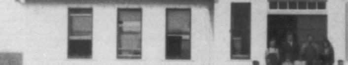
2 7. Description Condition X excellent good fair deteriorated ruins unexposed Check one unaltered X altered Check one original site loqn* i. -L./3U, X moved date 1976 Describe the present and original (if known) physical appearance Melvin School is a frame one-room schoolhouse-1---with three bays on either side of a central projecting enclosed entryway. It was built in 1922 on the west side of Cherry Creek in the community of Melvin, Arapahoe County (see photo //I). It was the second of two schools serving this small farming community which was located twelve miles southeast of Denver. The school, erected on land donated by one of the farmers, was constructed in an open field immediately east of the old Sullivan Road at Belleview Avenue. ' Melvin School served approximately twenty-five families, many of whom had homesteaded their land. These farm families were within a radius of two to three miles from the school. The schoolhouse -which also served as a community building remained at its original site until 1950 when the land on which it was built was condemned for the construction of Cherry Creek Dam. When the dam was completed, nothing remained of Melvin. The school was sold at auction in 1950 to a private individual who moved it to the southwest corner of Quincy Avenue and Parker Road. At that time, the building was converted for use as a tavern. The changes made include blocking the original entrance and creating a kitchen in the northwest corner of the building (now used for storage). At some point the belfry was removed. When the second site was zoned for commercial development in 1975 and the school slated for destruction, a movement was initiated to save the building. The Cherry Creek Valley Historical Society was formed and negotiations ensued with the school board to find a location for the structure. After the building was acquired by the Cherry Creek Valley Historical Society, it was placed on a truck, and moved to its present location. No damage to the building was incurred by the move. Since 1976, Melvin School has been on the Laredo Middle School-Smoky Hill High School campus of Cherry Creek School District. This is its permanent location approximately three miles from its original site. The building has since undergone a meticulous restoration, with guidance provided by the Cherry Creek Valley Historical Society. The building now sits on a grassy knoll of approximately one-half acre, with a parking area separating the 1922 school from the high school and a grassed area between it and the Laredo Middle School. The site was selected to recreate, in some manner, the original isolated setting. Melvin School is rectangular in shape (60' x 25') with a central projecting vestibule (10' x 17' anteroom). The one-story structure has nine bays, including a double-door entry, in the main facade; the rear elevation has six bays including five windows and an emergency door exit (originally a sixth window) to meet modern fire requirements; the remaining two facades have no bays. The cedar shingle roof is a high gable. The rafters project under the roof eaves. The secondary features are very simple. They reflect the time, economy, location, and purpose of the building. The exterior walls are sheathed with narrow (3-3/8"), horizontal clapboard, painted white, and the wall framing is of diagonal plank. There are no design patterns on the exterior walls. Above the double-door entry of the main facade is a sign denoting the structure as "District No. 4, Melvin School" and above (see continuation sheet)

3 NPS Form a 0MB No (3-82) Exp United States Department of the Interior National Park Service National Register of Historic Places Inventory Nomination Form Continuation sheet MELVIN SCHOOL Item number 7 Page 2 this on the roof line is a square belfry holding the school bell (see photos #1 and #3). (The belfry was recreated using photo documentation. The exact measurements of the original were determined and replicated.) All windows are similar in construction with flat heads, a narrow lintel, one over one and double hung with plain lugsill and molded side trim. The trim on the window screen is dark green. The original building had a basement. There are four risers on three sides of the 8' x 10' cement platform at the center of the main facade. The exterior of the building has been authentically restored based on photographs loaned by former students. Most of the interior has also been authentically restored walls, floors, ceiling, light fixtures, curtains, and room partition. The original floor has been uncovered. (Two layers of linoleum covered it while it served as a tavern.) The anteroom and one classroom demonstrate the architecture and furnishings of a 1920 's rural schoolhouse (see photos #7 and #9). The second original classroom has been adaptively restored into a museum-library and office area (see photos #8 and #10). The decision to adaptively restore at least part of the former two-classroom schoolhouse arose from the need to have a local history repository and an actual historic setting for the interpretation of local history. Many former students who lived in the Melvin community and attended Melvin School helped in the restoration process by supplying information, helping in the restoration, and donating items of historic value for the museum-library. Many high school students, service organizations, businesses, the Colorado Historical Society (grants), the Cherry Creek School District, and the Cherry Creek Valley Historical Society joined together in the common goal of restoring the Melvin School into the Melvin Schoolhouse Museum-Library as a showpiece of authentic and adaptive restoration techniques resulting in a building which would once again serve as a community and educational center. The theme for the restoration was "Restored By The Community For The Community." The Melvin Schoolhouse Museum-Library was dedicated in September of The building is larger than a typical one-room schoolhouse because it actually contains two rooms, separated today as it was originally by folding doors placed just to the side of the two classroom doors.

4 8. Significance Period Areas of Significance Check and justify below prehistoric areheoloav-orehistoric communitv olannina x _ archeology-historic agriculture _JL. architecture art commerce communications conservation economics _ X- education engineering exploration/settlement industry invention landscape architecture law literature military music philosophy politics/government religion science sculpture social/ humanitarian theater transportation other (specify) Specific dates 1922 Builder/Architect Ren and Henry DeBoer Statement of Significance (in one paragraph) The Melvin School is significant for its role in rural education in the farming community of Melvin between 1922 and 1949 and for its use as a community center during those years. Because of its excellent state of preservation, it is also an important representative of the design of rural schoolhouses built in Colorado during the first quarter of the twentieth century. The history of Melvin dates to the Colorado Gold Rush of 1859 when thousands of gold seekers and settlers traveled the Smoky Hill Trail to the Denver area. The community of Melvin developed as a result of this immigration. It was named after John G. Melvin of Connecticut who settled on 320 acres along Cherry Creek, twelve miles southeast of the young community of Denver. He and his wife enlarged their home and opened it to travelers in 1868 as the Twelve Mile House, the largest of the chain of mile houses on the Smoky Hill Trail in Colorado. (The mile house number denoted the distance from Denver.) A one-room Cherry Creek School was built in 1874, but as the community grew and there became a need for a second, larger school and a larger community center, the two-room Melvin School was built. From an architectural perspective, the Melvin School reflects the vernacular style of rural schoolhouses of the early twentieth century narrow clapboard, unadorned walls, gabled roof, and a belfry to house the school bell. The simple design and absence of decorative elements testify to the needs, attitudes, and economics that governed education in the area. The Melvin School (Arapahoe County School District No. 4) served the northern and western sections of the Melvin community; the smaller Cherry Creek School served the less populated southern and eastern sections. After its construction, Melvin School became the more important of the two in terms of a community focal building, because it served as a community center as well as a school. (The Cherry Creek School was later sold and relocated on Cherry Creek High School dampus.) When the Melvin School doors opened in the fall of 1922, there were twenty-six students and two teachers, one for the primary class (grades 1-6) and one for the secondary class (grades 7-10). During classroom hours, the schoolhouse was effectively divided into two rooms by two large, accordion type folding doors. From 1922 through the school year, two teachers were employed to instruct an average of thirty students in grades one through twelve. After 1930, the older students were sent to Denver area high schools and the attendance at Melvin School dropped to an average of eighteen students in grades one through nine. During these years ( ), only one teacher was employed and only one of the two classrooms was used for classroom purposes.
5 9. Major Bibliographical References (see continuation sheet) 10. Geographical Data Acreage of nominated property 0.4 acres Quadrangle name Fitzsimons, Colorado UTM References Zone c E Gl. 1 5 ll 6\ 9i*tiO Easting i , e> 8 0 North ing i l Verbal boundary description and justification > 1 '! 1 F l H 1 Zone LjJ i 1 L^J l Easting 1 Quadrangle scale 1:24,000 I 1 1 I, 1,, i i 1 i I North ing See Map 2 for boundary delineation. Nominated is the building and the grassed lot on:.which the structure is located. List all states and counties for properties overlapping state or county boundaries state None code county code state code county code 11. Form Prepared By,, 1 i i i i i i i i i i i name/title Clarice M. Crowle, Director, Melvin Schoolhouse Museum-Library organization Cherry Creek Valley Historical Society, InQate June 13, 1983 street & number 4950 South Laredo Street telephone (303) city or town Aurora state Colorado State Historic Preservation Officer Certification The evaluated significance of this property within the state is: national state v local As the designated State Historic Preservation Officer for the National Historic Preservation Act of 1966 (Public Law ), I hereby nominate this property for inclusion in the National Register and certify that it has been evaluated according to the criteria and procedures set forth bynrje National Park Service State Historic Preservation Officer signature title State Historic Preservation Officer date November 9, 1983,r%r W^Mt»<»!!y- >:. : '. ' ; / -.. ''.. ",' : - -^ I hereby certify that this property is included in the National Register } Entered itt,*"^^

6 NPS Form a 0MB No (3-82) Exp United States Department of the Interior National Park Service National Register of Historic Places Inventory Nomination Form Continuation sheet KELVIN SCHOOL Item number 8 Page 2 As a result of the 1933 collapse of the Castlewood Dam south of Franktown on Cherry Creek, the federal government condemned land in the Melvin community for the building of the Kenwood Dam (1935). When this dam proved inadequate, a second condemnation of Melvin community land was made in 1949 for the building of the Cherry Creek Dam and Reservoir. This condemnation included the Melvin School, the Twelve Mile House, and several other homes and barns in the area. The Melvin School was sold and moved to the southwest corner of Parker Road and Airline Road (now Quincy Avenue) in Section 12, about 1% miles northeast of its original site. A federal project, therefore, forced this first moving of the Melvin School. The Melvin School stood on this relocated site for over twenty-five years, although it did not serve as a school or a community center during that time. It was rebuilt into a tavern and served in that capacity until Later it was vacated and allowed to deteriorate. In 1975, the leasee of the land on which the vacant building was located applied for rezoning with plans to build a gas station. He anticipated that the building on the site would be demolished. The Melvin School's second move was to save it from this fate. Fortunately, five local citizens felt that this tangible symbol of the Melvin community should be preserved, and they incorporated as the Cherry Creek Valley Historical Society to save the schoolhouse. They convinced the leasee to donate the building to the Society in trade for their moving it off the site, leveling the site, and cleaning up the debris. The old Melvin School was moved to the Laredo Middle School Smoky Hill High School campus of the Cherry Creek School District to become a classroom-museum-library for students of all ages to enjoy. The restoration was under the supervision of the Cherry Creek Valley Historical Society. The building was moved in December of 1976 and the restoration took place over the following six years. The restoration became a community effort as many organizations, businesses, and individuals became interested in the project and donated labor, materials, and/or money toward the completion of the building. As a result, a great deal of pride has been generated among community members. The Cherry Creek School District played an exceedingly important role in the restoration of the Melvin School because it felt that it was an important educational tool for community use. The District not only paid for the foundation, after approving the relocation of the building onto school district property, but continued to help in the restoration. Because of this cooperation and the fact that the building was on school district property, the Cherry Creek Valley Historical Society donated the building to the school district with the understanding that the historical society would complete the restoration, would furnish the building with items of historic interest, and would maintain an interpretative program, the museum, and the library. The school district assumed the responsibility of maintaining the building and paying the utilities. The Melvin School was dedicated as the Melvin Schoolhouse Museum-Library in September of 1982 as a tangible link with the history of the area. It is located between the fork of the Middle Smoky Hill Trail as it nears Cherry Creek. (see continuation sheet)

7 NPS Form a 0MB No (3-82) Exp United States Department of the Interior National Park Service National Register of Historic Places Inventory Nomination Form Continuation sheet Melvin School Item number 8 Page 3 The community of Melvin structurally no longer exists, but its memory and the history of the entire Cherry Creek area will continue to live on due to the efforts of the Cherry Creek Valley Historical Society, the Cherry Creek School District, and interested members of the community who restored the Melvin School, the proud symbol of a community whose days have passed by but whose spirit lives on.
8 NPS Form a (3-82) United States Department of the Interior National Park Service National Register of Historic Places Inventory Nomination Form MELVIN SCHOOL Continuation sheet Item number OMB No Exp Page APPENDIX A MELVIN SCHOOL TEACHERS School Year Teachers Cecelia Fitzgerald Madelon Jacobucci Kathleen Berryman Gladys Gidley Minnie O. Davis Elbert Coates Vada Hoover Emile Fredrickson Fresno McKay Emile Fredrickson Harold S. Williams R. Mitchel McClure R. Mitchel McClure Anna Grain Ruth Ryan Helen M. Ells worth Arvil D. McClure Hilda E. Carlson Gladys Woodhouse Lanora Rittenhouse Rebecca Armstrong Anna J. Myer Grades Taught
9 NPS Form a OMB No (3-82) Exp United States Department of the Interior National Park Service National Register of Historic Places Inventory Nomination Form Continuation sheet MELVIN SCHOOL Item number 9 Page 9 Goe, Donald K., and Crowle, Clarice M. The History of Cherry Creek School District Number Five, Publisher: Cherry Creek School District, 1981, pp Harvey, James. "The Twelve Mile House Recollections of Mrs. Jane Melvin," Colorado Magazine, 12 (September 1935), pp Long, Margaret, The Smoky Hill Trail, W. H. Kistler Stationery Co., publishers, 1953 Interviews with former students and teachers Hilda Carlson Anderson and Fred Dransfeldt.
10 Melvin Schoo Arapahoe County, Colorado LEGEND 1. Original site of Melvin School 2. Old Melvin Bridge (not in use) 3. Smoky Hill High School MELVIN SCKOOLHOUSE MUSEUM-LIBRARY LAREDO MIDDLE SCHOOL For information call Clarice Growle at MELVIN SCHOOLHOUSE MUSEUM LIBRARY 4950 South Laredo Street, Aurora, Colorado MAP 1


11 irrn
 Year: 1931 Location of negative: Alfred J.")

12 #1 Melvin School (Arapahoe County School District Arapahoe County, Colorado Photographer: unknown (photo loaned by May Obrecht) Year: 1931 Location of negative: Alfred J. Crowle (copy of original photo) East Costilla Ave. Aurora, CO Front view looking east (on original site at Belleview Avenue and _.._ _._.. the old Sullivan Road (now Jordan Road)


13 !

14 #2.._.._..._ Melvin School "before restoration Arapahoe County, Colorado Photographer: Alfred J. Crowle. Year: 1977 Location of negative: Crowle file East Costilla Ave. Aurora, CO Side view looking southwest (on Cherry Creek School District site at 4950 So. Laredo Street, Aurora, CO)


15 DISTRICT W 4 ~ MELVIN SCHOOLS?
 Location of negative: Crowle file 16815 East Costilla Ave.")
16 #3 '"" " " " ' Melvin School after restoration (Melvin Schoolhouse Museum-Library) Arapahoe County, Colorado Photographer: Alfred J. Crowle Year: 1983 (5/28/83) Location of negative: Crowle file East Costilla Ave. Aurora, CO Front view looking west (on Cherry Creek School District site at 4950 South Laredo Street, Aurora, CO)


17 f

18 #4 Melvin School after restoration (Melvin Schoolhouse Museum-Library) Arapahoe County, Colorado Photographer: Alfred J. Crowle Date: May 28, 1983 Location of negative: Crowle file East Costilla Ave. Aurora, CO Back view looking northeast (on Cherry Creek School District site at 4950 So. Laredo Street, Aurora, GO)


19 opaaen i^nos OG6P

20 #5 Melvin School after restoration (Melvin Schoolhouse Museum-Library) Arapahoe County, Colorado Photographer: Date: Location of negatives Alfred J. Crowle May 28, 1983 Crowle file East Costilla Ave. Aurora, CO Side view looking south (on Cherry Creek School District site at ^950 So. Laredo Street, Aurora, CO)


21 I
22 #6 Melvin School after restoration (Melvin Schoolhouse Museum-Library) Arapahoe County, Colorado Photographer: Alfred J. Crowle Date: May 28, , Location of negative: Crowle file East Costilla Ave. Aurora, CO Front view looking northwest (on Cherry Creek School District site at 4950 So. Laredo Street, Aurora, CO)


23 H a 3 E

24 #7 ' " Melvin School after restoration authentically restored classroom (Melvin Schoolhouse Museum-Library) Arapahoe County, Colorado Photographer: ' Alfred J. Crowle : Date: May 28, 1983 ' ' Location of negative: Growle file ' East Costilla Ave. Aurora, CO Interior view looking south (on Cherry Creek School District site at 4950 So. Laredo Street, Aurora, CO)


25 - J...M. \\1
 Arapahoe County, Colorado Photographer: Alfred J.")

26 #8 Melvin School after restoration adaptively restored museum-library (Melvin Schoolhouse Museum-Library) Arapahoe County, Colorado Photographer: Alfred J. Crowle Date: May 28, 1983 Location of negative: Crowle file East Costilla Ave. Aurora, CO Interior view looking south (on Cherry Creek School District site at So. Laredo Street, Aurora, CO)


27 II r
 Arapahoe County, Colorado Photographer: Alfred J.")

28 #9 Melvin School after restoration classroom with museum-library in back. (Melvin Schoolhouse Museum-Library) Arapahoe County, Colorado Photographer: Alfred J. Crowle Date: May 28, 1983 Location of negative: Crowle file East Costilla Avenue Aurora, CO Interior view looking north (on Cherry Creek School District site at 4950 So. Laredo Street, Aurora, CO)


29 MELVIN SCHOOL RESTORATION MELVIN PAINT RESEARCH iun UUTIK KUICr SWdf. (mine OOKIi Una %.»» If * yxmk IDUTHM V SAHPOS WTtH MNT COU» i^'
 Arapahoe County, Colorado Photographer: Date: Location of")

30 #10 Melvin School after restoration restoration display in museum-library (Melvin Schoolhouse Museum-Library) Arapahoe County, Colorado Photographer: Date: Location of negative: Interior view east wall Alfred J. Crowle. May 28, 1983 Crowle file East Costilla Avenue Aurora, CO (on Cherry Creek School District site at So. Laredo Street, Aurora, CO)
NPS Form OMB No Exp Status occupied X unoccupied work in progress Accessible yes: restricted yes: unrestricted _5Lno
 NPS Form 10-900 OMB No. 1024-0018 Exp. 10-31-84 United States Department of the Interior National Park Service National Register of Historic Places Inventory Nomination Form See instructions in How to
3. Classification. 5. Location of Legal Description. 6. Representation in Existing Surveys
 N~~ Form 10.900 (382) OMB No. 10240018 Exp. 103164 United States Department of the Interior National Park Service National Register of Historic Places InventoryNomination Form See instructions in How to
National Register off Historic Places received NOV U 1985 Inventory Nomination Form date ante** DEC j 2 BBS
 NPS Form 10400 042) 0MB No. 1024-0018 Exp. 10-31-84 United States Department off the Interior National Park Service For NFS us* only National Register off Historic Places received NOV U 1985 Inventory
Places state West Virginia code county Marion
 NPS Form 1W0 csaa, United States Department of the lnteria? National Park Service National Register of Historic Inventory-Nomination Form See instructions in How to Complete National Register Forms Type
National Register of Historic Places received 9 Inventory Nomination Form date entered M/W 9 I9S
 NPS Form 10-900 0MB No. 1024-0018 (3-82) Exp. 10-31-84 For NPS use only National Register of Historic Places received 9 Inventory Nomination Form date entered M/W 9 I9S See instructions in How to Complete
TYPE ALL ENTRIES -- COMPLETE APPLICABLE SECTIONS. Elsenhower Memorial Chapel (unofficially)
") Form No 10-306 (Rev 10-74) UNlTEDSTATtS DEPARTMENT OK THt INTERIOR NATIONAL PARK SERVICE NATIONAL REGISTER OF HISTORIC PLACES INVENTORY - NOMINATION FORM FOR FEDERAL PROPERTIES SEE INSTRUCTIONS IN HOW
Form No 10-306 (Rev 10-74) UNlTEDSTATtS DEPARTMENT OK THt INTERIOR NATIONAL PARK SERVICE NATIONAL REGISTER OF HISTORIC PLACES INVENTORY - NOMINATION FORM FOR FEDERAL PROPERTIES SEE INSTRUCTIONS IN HOW
National Register of Historic Places Inventory Nomination Form. 1. Name. 2. Location. 3. Classification. 4. Owner of Property
 NFS Form 10-900 (3-82) 0MB No. 1024-0018 Expires 10-31-87 United States Department of the Interior National Park Service National Register of Historic Places Inventory Nomination Form See instructions
Maryland Historical Trust Inventory No. 15/6 Maryland Inventory of Historic Properties Form
 Inventory No. 15/6 Maryland Inventory of 1. Name of Property (indicate preferred name) historic Becraft Farm other 2. Location street and number 28500 Ridge Road not for publication city, town Mount Airy
CJheck one original s ite moved date
 FHR-8-300 (11-78) United States Department off the Interior Heritage Conservation and Recreation Service National Register of Historic Places Inventory Nomination Form See instructions in How to Complete
- - CITY. TOWN CONGRESSIONAL DISTRICT. Princeton, VICINITY OF. STATE CODE COUNTY CODE West Virginia 54 Mercer 055
 UNITtD S DEPAKTMkNT OF THE IN1 EKIOR NATIONAL PARK SERVICE NATIONAL REGISTER OF HISTORIC PLACES INVENTORY -- NOMINATION FORM NAME HISTORIC AND/OR COMMON SEE INSTRUCTIONS IN HOW TO COMPLETE NATIONAL REGISTER
Maryland Historical Trust Inventory No. PG: 86A-026 Maryland Inventory of Historic Properties Form
 Inventory No. PG: 86A-026 Maryland Inventory of 1. Name of Property (indicate preferred name) historic other 2. Location street and number 12811 Croom Road not for publication city, town Naylor vicinity
Langley Register of Historic Places Nomination Form
 FOR OFFICE USE ONLY Langley Register of Historic Places Nomination Form Received Type all entries 1. Name of Property Historic: Jacob Anthes Bunkhouse/Cookhouse And/or common: South Whidbey Historical
 Page 1 Original Update HISTORICAL STRUCTURE FORM FLORIDA MASTER SITE FILE Consult Guide To Historical Structure Forms for detailed instructions Site # 8OR9844 Recorder # 26 Recorder Date 2/20/08 Site Name
3. Classification -- Category Ownership Status Present Use
 United States Department of the Interior National Park Service?htbn~! Register of klkt~rk Places For HPS UM only received Inventory-Nomination Form date entered See instructions in How to Complete National
"The Stone House;" Parker Family Residence; Slosn, Richard, House. Route 50 approximately 314 mile east of Junction
 Form No. 10300 (Rev. 1074) UNITED STATES DEPARTMENT OF THE INTERIOR NATIONAL PARK SERVICE NATIONAL REGISTER OF HISTORIC PLACES INVENTORY NOMINATXON FORM @NAME HISTORIC SEE INSTRUCTIONS IN HOW TO COMPLETE
6. Representation in Existing Surveys. National Register of Historic Places Inventory Nomination Form. 1. Name. 4. Owner of Property !
 NPS Form 10-900 (3-82) OMB No. 1024-0018 Exp. 10-31-84 United States Department of the Interior National Register of Historic Places See instructions in How to Complete National Register Forms Type all
National Register of Historic Places Inventory-Nomination Form. I. Name. 5. Location of Lesal Descri~tion
 United States Department of the Interior National Park Service National Register of Historic Places Inventory-Nomination Form See instructions in How to Complete National Register Forms Type all entries-complete
SEE INSTRUCTIONS IN HOWTO COMPLETE NATIONAL REGISTER FORMS TYPE ALL ENTRIES - COMPLETE APPLICABLE SECTIONS NAME VICINITY OF CODE STATUS
 Form No. 10-300 ^ \Q- UNITED S DEPARTMENT OF THE INTERIOR NATIONAL PARK SERVICE NATIONAL REGISTER OF HISTORIC PLACES INVENTORY -- NOMINATION FORM SEE INSTRUCTIONS IN HOWTO COMPLETE NATIONAL REGISTER FORMS
; * --.-.,., rj ; United States Department of the Interior \ ' '"] I National Park Service
![; * --.-.,., rj ; United States Department of the Interior \ ' '] I National Park Service](/thumbs/88/117765392.jpg "; * --.-.,., rj ; United States Department of the Interior \ ' '] I National Park Service") NPS Form 10-900 OMB No. 1024-0018 (Rev. 10-90) : / i' -_ :. - : ; ; * --.-.,., rj ; United States Department of the Interior \ ' '"] I National Park Service NATIONAL REGISTER OF HISTORIC PLACES REGISTRATION
NPS Form 10-900 OMB No. 1024-0018 (Rev. 10-90) : / i' -_ :. - : ; ; * --.-.,., rj ; United States Department of the Interior \ ' '"] I National Park Service NATIONAL REGISTER OF HISTORIC PLACES REGISTRATION
Maryland Historical Trust Inventory No. PG: 75A-007 Maryland Inventory of Historic Properties Form
 Inventory No. PG: 75A-007 Maryland Inventory of 1. Name of Property (indicate preferred name) historic other 2. Location street and number 3101 Ritchie Road not for publication city, town Forestville vicinity
Status occupied unoccupied work in progress Accessible yes: restricted _X-_ yes: unrestricted no. Jackson County Courthouse
 NPS Form 10-900 (3-82) OMB No. 1024-0018 Exp. 10-31-84 United States Department of the Interior National Park Service National Register of Historic Places Inventory Nomination Form See instructions in
Commonwealth of Massachusetts Massachusetts Historical Commission 220 Morrissey Boulevard, Boston, Massachusetts
 Inventory No: Historic Name: Common Name: Address: HRV.165 Blood, Joseph House Farnsworth, Jonathan - Beaman, Jonathan House 74 Poor Farm Rd City/Town: Village/Neighborhood: Local No: 9-17 Year Constructed:
Maryland Historical Trust Inventory No. PG: 86A-003 Maryland Inventory of Historic Properties Form
 Inventory No. PG: 86A-003 Maryland Inventory of 1. Name of Property (indicate preferred name) historic other 2. Location street and number 12005 Duley Station Road not for publication city, town Upper
ate: AR County: Pulaski Code: AR Zip Code: Noncontributing buildings sites structures objects Total
 Mims-Ereedlove-Priest-Weatherton House Name of Property Little Rock, AR County and State ~- -,s Form 10-900 'V. 8-86) OMB No. 1024-0018 United States Department of the Interior National Park Service NATIONAL
Maryland Historical Trust Inventory No Maryland Inventory of Historic Properties Form
 Inventory No. 15 28 Maryland Inventory of 1. of Property (indicate preferred name) historic Luther Moore Farm other 2. Location street and number 7201 Damascus Road not for publication city, town Gaithersburg
Town: Sharon Place (neighborhood or village): Sharon. ame of Area: Present Use: Date (month / year): July 2008
: Sharon. ame of Area: Present Use: Date (month / year): July 2008") FORM A - AREA MASSACHUSETTS HISTORICAL COMMISSION MASSACHUSETTS ARCHIVES BUILDING 220 MORRISSEY BOULEVARD BOSTON, MASSACHUSETTS 02125 Photograph Assessor s Sheets USGS Quad Area Letter Form Numbers in
FORM A - AREA MASSACHUSETTS HISTORICAL COMMISSION MASSACHUSETTS ARCHIVES BUILDING 220 MORRISSEY BOULEVARD BOSTON, MASSACHUSETTS 02125 Photograph Assessor s Sheets USGS Quad Area Letter Form Numbers in
Maryland Historical Trust Inventory No. PG: Maryland Inventory of Historic Properties Form
 Inventory No. PG: 62-012 Maryland Inventory of 1. Name of Property (indicate preferred name) historic other 2. Location street and number 11205 Old Baltimore Pike not for publication city, town Beltsville
National Register off Historic Places Inventory Nomination Form
 NPS Fomi ia-900-a OMB Ho. 1024-0018 Exp. 10-31-S4 United States Department of the Interior National Park Service National Register off Historic Places Inventory Nomination Form For HPS UM only received
Address 347 Whitney Street. East elevation, camera facing southwest.
 FORM B BUILDING Assessor s Number USGS Quad Area(s) Form Number MASSACHUSETTS HISTORICAL COMMISSION MASSACHUSETTS ARCHIVES BUILDING 220 MORRISSEY BOULEVARD BOSTON, MASSACHUSETTS 02125 Town Northborough
MINNESOTA HISTORIC.PROPERTIES INVENTORY FORM. Yes_ No X Restricted
 HISTORIC NAME: CURRENT NAME: LEGAL DESC.: MINNESOTA HISTORIC.PROPERTIES INVENTORY FORM Hartley Sugar Camp W % of Gov't. Lot 3 and T55, R24, Sec. 9 COUNTY: Itasca CITY/TWP.: Trout Lake Twp. ADDRESS: of
THE BARNACLE 3485 MAIN HIGHWAY
 THE BARNACLE 3485 MAIN HIGHWAY Designation Report City of Miami REPORT OF THE CITY OF MIAMI PLANNING AND ZONING DEPARTMENT TO THE HISTORIC AND ENVIRONMENTAL PRESERVATION BOARD ON THE POTENTIAL DESIGNATION
street & number: COUNTY ROUTE 3, HC-88, BOX 17 not for publication: N/A city/town: WHEELER vicinity: X state: WV county: WEBSTER code: 101 zip code:
 NPS Forn 10-900 OMB No. 10024-0018 (Oct. 1990) United States Department of the Interior National Park Service NATIONAL REGISTIR OF HISTORIC PLACES REGISTRATICN FCRX =========================================================---------=======
APPENDIX K: BUILT HERITAGE AND CULTURAL HERITAGE LANDSCAPES
 APPENDIX K: BUILT HERITAGE AND CULTURAL HERITAGE LANDSCAPES TABLE 1: Built Resources (BHR) and Cultural Heritage Landscapes (CHL) Within and Adjacent to the West Whitby Secondary Plan Area Site # 1. CHL
National Register off Historic Places Inventory Nomination Form
 MPS Fonn 10-900-a (3^ United States Department of the Interior National Park Service National Register off Historic Places Inventory Nomination Form For NPS use only received date entered OMB No 1M4-0018
NE¼ of NE¼ of NE¼ of NE¼ of section Roof configuration (enter one): Gabled Roof / Front Gabled Roof
: Gabled Roof / Front Gabled Roof") OAHP1403 Rev. 9/98 COLORADO CULTURAL RESOURCE SURVEY Official Eligibility Determination (OAHP use only) Date Initials Determined Eligible - National Register Architectural Inventory Form Determined Not
OAHP1403 Rev. 9/98 COLORADO CULTURAL RESOURCE SURVEY Official Eligibility Determination (OAHP use only) Date Initials Determined Eligible - National Register Architectural Inventory Form Determined Not
National Register of Historic Places Registration Form
 NPS Form 10-900 OMB No. 10024-0018 (Oct. 1990) United States Department of the Interior National Park Service National Register of Historic Places Registration Form 1. Name of Property historic name Hickory
HISTORIC SITE FORM HISTORIC SITES INVENTORY
 HISTORIC SITE FORM HISTORIC SITES INVENTORY 1 IDENTIFICATION Name of Property: House at 569 Park Avenue PARK CITY MUNICIPAL CORPORATION (10-08) Address: 569 Park Avenue City, County: Park City, Summit
Maryland Historical Trust Inventory No. PG: 81B-008 Maryland Inventory of Historic Properties Form
 Maryland Historical Trust Inventory No. PG: 81B-008 Maryland Inventory of 1. Name of Property (indicate preferred name) historic other 2. Location Dyson Farmhouse (preferred) street and number 13010 Piscataway
- vicinity of. Status. Present Use. occupied agriculture A!- museum t -L structure - both - work in progress - educational private residence
 Unitad States Department of the Interior - National Park Service - ational Register of Historic Places -- - inventory-nomination Form See instructions in How to Complete National Register Forms Type all
Architectural Inventory Form
 OAHP1403 Rev. 9/98 COLORADO CULTURAL RESOURCE SURVEY Architectural Inventory Form Official eligibility determination (OAHP use only) Date Initials Determined Eligible- NR Determined Not Eligible- NR Determined
National Register of Historic Places Registration Form
 NPS Form 10-900 OMB No. 10024-0018 (Oct. 1990) United States Department of the Interior National Park Service National Register of Historic Places Registration Form 1. Name of Property historic name other
FLAGLER WORKER S HOUSE FORT DALLAS PARK S.E. 4 STREET
 FLAGLER WORKER S HOUSE FORT DALLAS PARK 60-64 S.E. 4 STREET Designation Report City of Miami REPORT OF THE CITY OF MIAMI PLANNING DEPARTMENT TO THE HERITAGE CONSERVATION BOARD ON THE POTENTIAL DESIGNATION
National Register of Historic Places Inventory Nomination Form
 NPS Form 10-900-a Exp. 10-31-84 Continuation sheet 4 5 item number 7 Page 45 NAME: Knight Estate LOCATION: 486 East Avenue,,--v..u^-^ OWNER: State of Rhode Island Department of Education Board of Regents
National Register of Historic Places Multiple Property Documentation Form
 NPS Form 10-900-b OMB No. 1024-0018 Revised Aug. 2002 Expires 12-31-2005 Multiple Property Documentation Form This form is for use in documenting multiple property groups relating to one or several contexts.
Status XX occupied unoccupied work in progress Accessible XX yes: restricted yes: unrestricted no. Zorn Farms, Inc., and Henry Zorn Estate
 FHR-8-300 (11-78) United States Department of the Interior Heritage Conservation and Recreation Service National Register of Historic Inventory Nomination Form See instructions in How to Complete National
Riverside County Landmark Application Lawler Lodge
 November 20, 2014 Agenda Item: 9.3 Job Code: 2014-11 Riverside County Landmark Application Lawler Lodge 1. SITE NAME: a. Historic: Lawler Park, Lawler Lodge b. Common: Lawler Lodge 2. LOCATION: a. Address:
Status X occupied unoccupied X work in progress Accessible X yes: restricted - yes: unrestricted np. Clackamas County Courthouse.
 NFS Form 10-900 (3-82) United States Department of the Interior National Park Service National Register of Historic Places Inventory Nomination Form See instructions in How to Complete National Register
Appendix D Reevaluation of Structures on Bock House Property
 Appendix D Reevaluation of Structures on Bock House Property Page 1 Original Update HISTORICAL STRUCTURE FORM FLORIDA MASTER SITE FILE Consult Guide To Historical Structure Forms for detailed instructions
United States Department of the Interior National Park Service NATIONAL REGISTER OF HISTORIC PLACES REGISTRATION FORM. Wilmoth, Bernard E.
 NPS Form 10-900 OMB No. 10024-0018 (Oct. 1990) United States Department of the Interior National Park Service NATIONAL REGISTER OF HISTORIC PLACES REGISTRATION FORM 1. Name of Property historic name: other
AH pp. I Ti. Nov 7 I) I I y
 I I y") ..------------------------------------------ ------------ - - -- - NPS Form 10-900 (Rev. 8-86) United States Department of the Interior ~a tional Park Service NATIONAL REGISTER OF HISTORIC PLACES REGISTRATION
..------------------------------------------ ------------ - - -- - NPS Form 10-900 (Rev. 8-86) United States Department of the Interior ~a tional Park Service NATIONAL REGISTER OF HISTORIC PLACES REGISTRATION
STATE CODE COUNTY CODE West Virginia 54 Greenbrier 025 STATUS ZOCCUPIED -UNOCCUPIED -WORK IN PROGRESS ACCESSIBLE YES: RESTRICTED
 "orm No. 10300 (Rev. 10741., US1TED STlITES DEPARTMENT OF THE INTERIOR NATIONAL PARK SERVICE FOR NPS USE ONLY NATIONAL REGISTER OF HISTORIC PLACES RECEtVEQ,/, INVENTORY NOMINATION FORM,., d' >A; 4y.. y
National Register of Historic Places Registration Form
 NPS Form 10-900 OMB No. 1024-0018 (Rev. 10-90) United States Department of the Interior National Park Service National Register of Historic Places Registration Form 1. Name of Property historic name Newcomer
SEE INSTRUCTIONS IN HOWTO COMPLETE NATIONAL REGISTER FORMS TYPE ALL ENTRIES - COMPLETE APPLICABLE SECTIONS NAME VICINITY OF CODE STATUS
 Form No. 10-300, \Q-1 \&V UNITED STATES DEPARTMENT OF THE INTERIOR INVENTORY - NOMINATION FORM SEE INSTRUCTIONS IN HOWTO COMPLETE NATIONAL REGISTER FORMS TYPE ALL ENTRIES - COMPLETE APPLICABLE SECTIONS
THE CORPORATION OF THE TOWN OF NIAGARA-ON-THE-LAKE. BY-LAW NO (214 Four Mile Creek Road)
") THE CORPORATION OF THE TOWN OF NIAGARA-ON-THE-LAKE BY-LAW NO. 4807-15 (214 Four Mile Creek Road) A BY-LAW TO DESIGNATE THE PROPERTY KNOWN MUNICIPALLY AS WOODBOURNE, 214 FOUR MILE CREEK ROAD, IN THE TOWN
THE CORPORATION OF THE TOWN OF NIAGARA-ON-THE-LAKE BY-LAW NO. 4807-15 (214 Four Mile Creek Road) A BY-LAW TO DESIGNATE THE PROPERTY KNOWN MUNICIPALLY AS WOODBOURNE, 214 FOUR MILE CREEK ROAD, IN THE TOWN
NPS Form OMB No (Oct. 1990)
") NPS Form 10-900 OMB No. 10024-0018 (Oct. 1990) United States Department of the Interior National Park Service NATIONAL REGISTER OF HISTORIC PLACES REGISTRATION FORM 1. Name of Property historic name:_lost
NPS Form 10-900 OMB No. 10024-0018 (Oct. 1990) United States Department of the Interior National Park Service NATIONAL REGISTER OF HISTORIC PLACES REGISTRATION FORM 1. Name of Property historic name:_lost
Abandoned or Vacant; Agricultural; Camp; Other Residential Agriculture; Archaeology, Historic; Architecture; Politics Government; Social History
 Inventory No: Historic Name: HRV.G Civilian Conservation Camp Common Name: Address: City/Town: Village/Neighborhood: Local No: 13-7.01 Year Constructed: Architect(s): Architectural Style(s): Use(s): Significance:
ADDENDUM. Chain of Title. Block C, Lot 8-9. Adrian I. Velthuis and Floyd T. Grant to Lottie Thompson
 Chain of Title Block C, Lot 8-9 NLP 5175:842 October 18, 1979 NLP 4979:58 October 5, 1977 NLP 4763:448 May 11, 1977 Adrian I. Velthuis and Floyd T. Grant to Lottie Thompson Gentlemens II Properties, Inc.,
Current Functions (Enter categories from instructions) Materials (Enter categories from instructions)
 Materials (Enter categories from instructions)") Site Inventory Form State Inventory No. 92-00542 New Supplemental State Historical Society of Iowa Part of a district with known boundaries (enter inventory no.) 92-00349 (November 2005) Relationship:
Site Inventory Form State Inventory No. 92-00542 New Supplemental State Historical Society of Iowa Part of a district with known boundaries (enter inventory no.) 92-00349 (November 2005) Relationship:
State Level Historic Documentation Report. John Blue Bridge Hampshire County
 State Level Historic Documentation Report State Project No. S314-28-22.27 Federal Project No. BR-0028(058)D John Blue Bridge Hampshire County Prepared by: Randy Epperly, Historian Department of Transportation
OR THEMATIC NOMINATION. STREET & NUMBER W side of SR l48s, 1.S mil. N of Muddy Creek _N()T FOR PUBLICATION CITY, TOWN. CONGRESSIONAL DISTRICT Arcadia
T FOR PUBLICATION CITY, TOWN. CONGRESSIONAL DISTRICT Arcadia") _--..,""'-"-_""-""- COUNTY xx::.c...- MULTIPLE RESOURCE OR THEMATIC NOMINATION HISTORIC Hampton House STREET & NUMBER W side of SR l48s, 1.S mil. N of Muddy Creek _N()T FOR PUBLICATION CITY, TOWN CONGRESSIONAL
_--..,""'-"-_""-""- COUNTY xx::.c...- MULTIPLE RESOURCE OR THEMATIC NOMINATION HISTORIC Hampton House STREET & NUMBER W side of SR l48s, 1.S mil. N of Muddy Creek _N()T FOR PUBLICATION CITY, TOWN CONGRESSIONAL
NPS Form (3-82) OMB No Expires
 OMB No Expires") NPS Form 10-900 (3-82) OMB No. 1024-0018 Expires 10-31-87 United States Department of the Interior National Park Service National Register of Historic Places Inventory Nomination Form See instructions
NPS Form 10-900 (3-82) OMB No. 1024-0018 Expires 10-31-87 United States Department of the Interior National Park Service National Register of Historic Places Inventory Nomination Form See instructions
Northwest Triangle. Redevelopment Proposal. Property Acquisition, Engineering, and Demolition. December, 2005 REDEVELOPMENT AUTHORITY OF THE
 Northwest Triangle Redevelopment Proposal Property Acquisition, Engineering, and Demolition December, 2005 REDEVELOPMENT AUTHORITY OF THE CITY OF YORK York City Redevelopment Authority 14 West Market Street,
Executive Summary. MASTER PLAN UPDATE Fort Collins-Loveland Municipal Airport
 Executive Summary MASTER PLAN UPDATE Fort Collins-Loveland Municipal Airport As a general aviation and commercial service airport, Fort Collins- Loveland Municipal Airport serves as an important niche
United States Department of the Interior National Park Service NATIONAL REGISTER OF HISTORIC PLACES REGISTRATION FORM
 NPS Form 10-900 (Rev. 8-86) OMB No. 1024-0018 United States Department of the Interior National Park Service NATIONAL REGISTER OF HISTORIC PLACES REGISTRATION FORM other name/site number: "Maple Shadows:"
NATIONAL REGISTER OF HISTORIC PLACES REGISTRATION FORM
 NPS Form 10-900 OMB No. 1024-0018 (Rev. 10-90) United States Department of the Interior National Park Service NATIONAL REGISTER OF HISTORIC PLACES REGISTRATION FORM 1. Name of Property historic name Compton-Johnson
Fletchertown (71A-022)
") Fletchertown (71A-022) Fletchertown is a late-nineteenth-century rural African-American community in northeastern Prince George s County. The community is located south of Huntington and northwest of Bowie.
Fletchertown (71A-022) Fletchertown is a late-nineteenth-century rural African-American community in northeastern Prince George s County. The community is located south of Huntington and northwest of Bowie.
MEDIA ADVISORY. FOR IMMEDIATE RELEASE November 12, 2012
 MEDIA ADVISORY FOR IMMEDIATE RELEASE November 12, 2012 Niagara-on-the-Lake On Monday, November 19, 2012, the Lord Mayor and members of the Town s Municipal Heritage Committee and War of 1812 Bicentennial
National Register of Historic Places Registration Form
 NPS Form 10-900 OMB No. 1024-0018 (Rev. 10-90) United States Department of the Interior National Park Service National Register of Historic Places Registration Form 1. Name of Property historic name Evans,
REGISTER OF HISTORIC KANSAS PLACES--COVER SHEET. N la' Lot 9 and all of Lots 10,11, and 12 (legal description) Hutchinson, Kansas (RENO)
 Hutchinson, Kansas (RENO)") Inventory Number REGISTER OF HISTORIC KANSAS PLACES--COVER SHEET Name of Property Women's Civic Center Club 1.56- \JGt,t,o - tj-,t.,'f Location 925 N. Main Street (street and number) Hutchinson (city,
Inventory Number REGISTER OF HISTORIC KANSAS PLACES--COVER SHEET Name of Property Women's Civic Center Club 1.56- \JGt,t,o - tj-,t.,'f Location 925 N. Main Street (street and number) Hutchinson (city,
Status x occupied unoccupied work in progress Accessible yes: restricted yes: unrestricted
 NPS Form 10-900 (342) OMB No. 1024-0018 Exp. 10-31-84 United States Department off the Interior National Register of Historic Places Inventory Nomination Form See instructions in How to Complete National
United States Department of the Interior National Park Service NATIONAL REGISTER OF HISTORIC PLACES REGISTRATION FORM
 NPS Form 10-900 (Oct. 1990) OMB No. 10024-0018 United States Department of the Interior National Park Service NATIONAL REGISTER OF HISTORIC PLACES REGISTRATION FORM 1. DR JOHN C. IRONS RESIDENCE hlstoric
National Register of Historic Places Registration Form
 NPS Form 10-900 OMB No. 10024-0018 (Oct. 1990) Registration Form This form is for use in nominating or requesting determinations for individual properties and districts. See instructions in How to Complete
National Register of Historic Places Registration Form
 NPS Form 10-900 OMB No. 1024-0018 (Expires 5/31/2012) United States Department of the Interior National Register Listed National Park Service May 1, 2012 National Register of Historic Places Registration
National Register of Historic Places Registration Form
 National Park Service National Register of Historic Places Registration Form This form is for use in nominating or requesting determinations for individual properties and districts. See instructions in
ATTACHMENT C ARLINGTON COUNTY REGISTER OF HISTORIC PLACES HISTORIC DISTRICT DESIGNATION FORM
 1. NAME OF PROPERTY ARLINGTON COUNTY REGISTER OF HISTORIC PLACES HISTORIC DISTRICT DESIGNATION FORM Historic Name: Other names: Reevesland Torreyson Farm 2. LOCATION OF PROPERTY Street and Number: 400
AHPP. LISTED ========================================================================
 NPS Form 10-900 (Rev. 8-86) Jnited States Department of the Interior ational Park Service OMB No. 1024-0018 LISTED NATIONAL REGISTER OF HISTORIC PLACES REGISTRATION FORM AHPP. 1. Historic Name: Bush-Dubisson
United States Department of the Interior National Park Service. Boundary Expansion Listed in National Register January 11, 2017
 NPS Form 10900-a (Rev. 8/2002) OMB No. 10240018 United States Department of the Interior National Park Service Boundary Expansion Listed in National Register January 11, 2017 National Register of Historic
STATE OF IOWA. Historical and Architectural Survey for 2008 Flood Projects in Vinton, Benton County
 STATE OF IOWA CHESTER J. CULVER GOVERNOR PATTY JUDGE LT. GOVERNOR DEPARTMENT OF PUBLIC DEFENSE IOWA HOMELAND SECURITY AND EMERGENCY MANAGEMENT DIVISION DAVID L. MILLER, ADMINISTRATOR Historical and Architectural
National Register of Historic Places Registration Form
 National Park Service National Register of Historic Places Registration Form This form is for use in nominating or requesting determinations for individual properties and districts. See instructions in
DESIGNATION REPORT KENNEDY-BAKER-WALKER-SHERRILL HOUSE (1849) 9320 KINGSTON PIKE (CLT ) KNOXVILLE, TENNESSEE July 12, 2007
 9320 KINGSTON PIKE (CLT ) KNOXVILLE, TENNESSEE July 12, 2007") DESIGNATION REPORT KENNEDY-BAKER-WALKER-SHERRILL HOUSE (1849) 9320 KINGSTON PIKE (CLT 132-027) KNOXVILLE, TENNESSEE July 12, 2007 Description The Kennedy-Baker-Walker-Sherrill House is located on the south
DESIGNATION REPORT KENNEDY-BAKER-WALKER-SHERRILL HOUSE (1849) 9320 KINGSTON PIKE (CLT 132-027) KNOXVILLE, TENNESSEE July 12, 2007 Description The Kennedy-Baker-Walker-Sherrill House is located on the south
NATIONAL PARK SERVICE CERTIFICATION OF COMPLETED SEGMENTS OF THE NORTH COUNTRY NATIONAL SCENIC TRAIL
 NATIONAL PARK SERVICE CERTIFICATION OF COMPLETED SEGMENTS OF THE NORTH COUNTRY NATIONAL SCENIC TRAIL Completed trail segments that (1) follow the route identified in the 1982 National Park Service (NPS)
A21 TONBRIDGE TO PEMBURY DUALLING. Statement of Case
 A21 TONBRIDGE TO PEMBURY DUALLING Statement of Case In Respect of Applications for the Demolition of Listed Buildings Under the Provisions of the Planning (Listed Buildings and Conservation Areas) Act
Maryland Historical Trust Inventory No Maryland Inventory of Historic Properties Form
 Inventory No. 32-31 Maryland Inventory of 1. Name of Property (indicate preferred name) historic Pinecrest Recreation Center 1 other Pinecrest Recreation Building (preferred) 2. Location street and number
September 13, Presented by: Jeremy Parsons PLANNING & ECONOMIC DEVELOPMENT DEPARTMENT
 Recommendation to Designate Property Located at 828 Sanatorium Road, Hamilton (Mountain Sanatorium Brow Campus) Under Part IV of the Ontario Heritage Act () September 13, 2018 Presented by: Jeremy Parsons
ri. Name historic: Oak Cliff United Methodist Church Date 7/17/97 and! or common:
 [ Dallas Landmark Landmark Nomination Commission Form ri. Name historic: Oak Cliff United Methodist Church Date 7/17/97 and! or common: L2. Location addresses: 541-49 E. Jefferson location! neighborhood:
National Register off Historic Places Inventory Nomination Form
 NPS Fomi 10-900 a OMB Mo. 1024-0018 Exp. 10-31-64 United States Department of the interior National Park Service National Register off Historic Places Inventory Nomination Form For NPS use only received
National Register of Historic Places Continuation Sheet
 Section number N/A Page 1 Proposed Amendment to Wichita, Sedgwick County, Kansas The owner of the building at 141 S. Rock Island Avenue requests amendment to the boundaries of the East Douglas Historic
about 1% miles south of Lahmansville STATE CODE COUNTY CODE West Virginia 5 4 Grant 023 X_OCCUPIED -BEING CONSIDERED -YES: UNRESTRICTED -NO
 Furm No. 10300 (Rev. 10.74) UNITED S DLPARTXIENT OF TIIE INTERIOR NATIONAL PARK SERVICE NATIaNAE REGISTER OF HSTORIC I? LACES INVENTORY NCIMINATICIET FORM I/Lkmm w NAME SEE INSTRUCTIONS IN HOW TO COMPLETE
RED HOUSE FARM NORTH NEWBALD, BEVERLEY, EAST YORKSHIRE
 RED HOUSE FARM NORTH NEWBALD, BEVERLEY, EAST YORKSHIRE Tel: 01653 697820 CHARTERED SURVEYORS AUCTIONEERS VALUERS LAND & ESTATE AGENTS FINE ART & FURNITURE RED HOUSE FARM NORTH NEWBALD BEVERLEY, EAST YORKSHIRE
301 7½ Street SW
 301 7½ Street SW 104-0213-0072 Primary Resource Information: Single Dwelling, Stories 2.00, Style: Other, ca 1890 July 2006: This late-19th-century, 3-bay, 2-story, hip-roofed frame I-house features projecting
FOREST FIRE LOOKOUT TOWERS OF THE ARAPAHO-ROOSEVELT NATIONAL FORESTS AND ROCKY MOUNTAIN NATIONAL PARK
 This site contains links to other Internet sites. These links are not endorsements of any products or services in such sites, and no information in such site has been endorsed or approved by the USDA Forest
National Register of Historic Places Registration Form
 NPS Form 10-900 OMB No. 1024-0018 (Rev. 10-90) United States Department of the Interior National Park Service National Register of Historic Places Registration Form 1. Name of Property historic name Strode-Morrison-Tabler
History/Descriptive Notes: 3.5 acres with orchard that was actively used until current owner purchased in 1982.
 Address: 4395 McCandlish Road Tax Parcel Number: 12-22-200-031 Year Built: 1926 (per owner) Architectural Style: Craftsman Other Buildings/Features: garage (date unknown) 61 History/Descriptive Notes:
Building Permit Application
 Building Permit Application Co-Owner Name Lot # Address City State Zip Phone (home) (cell) Contractor (if applicable) The above named co-owner hereby makes application to Cedar Shores Campground Condominium
Historic District Commission January 14, 2016 City of Hagerstown, Maryland
 Michael Gehr, chair, called the meeting to order at 4:30 p.m. on Thursday, January 14, 2016, in the Council Chamber, Second Floor, City Hall. A roster of the members of the commission and the technical
Sampson Veterans Memorial Cemetery: Administration Building A001.01
 Sampson Veterans Memorial Cemetery: Administration Building A001.01 HISTORY: The Sampson Veterans Memorial Cemetery is located on one of the most Building Area: (sf) significant military sites in New York
Late-nineteenth-century view of the Macy house on Liberty Street GPN2044. Nantucket Historical Association
 MACY-CHRISTIAN OLDEST HOUSE HOUSE Late-nineteenth-century view of the Macy house on Liberty Street GPN2044 10 Nantucket Historical Association MACY-CHRISTIAN» OLDEST HOUSE Macy-Christian House In the early
TRAIL MAPPING AND MARKING POLICY SANTA FE TRAIL ASSOCIATION Adopted by the Santa Fe Trail Association Board of Directors, April 13, 2002
 TRAIL MAPPING AND MARKING POLICY SANTA FE TRAIL ASSOCIATION Adopted by the Santa Fe Trail Association Board of Directors, April 13, 2002 INTRODUCTION There are three principle aspects to the marking of
Friends Meeting House, Leicester. 16 Queens Road, Leicester, LE2 1WP. National Grid Reference: SK Statement of Significance
 Friends Meeting House, Leicester 16 Queens Road, Leicester, LE2 1WP National Grid Reference: SK 59852 02815 Statement of Significance A meeting house purpose-built on a new site in 1955 and slightly enlarged
N/A not for publication city or town : Hillsboro - X vicinity state: West Virginia code: WV countv: Pocahontas code: 075 zip code: 24946
 United States Department of the Interior National Park Service historic name : other nameslsite number : NIA. -.- 2. Location street & number : HC 64. Box 147loff County Road 3 1 on Kyle Beard Road N/A