Status XX occupied unoccupied work in progress Accessible XX yes: restricted yes: unrestricted no. Zorn Farms, Inc., and Henry Zorn Estate
|
|
|
- Dwight Nash
- 5 years ago
- Views:
Transcription

1 FHR (11-78) United States Department of the Interior Heritage Conservation and Recreation Service National Register of Historic Inventory Nomination Form See instructions in How to Complete National Register Forms Type all entries complete applicable sections 1. Name 1 historic Zorn {Casper/ Farmhouse and/or common 2. Location Zorn House street & number 8448 Chamooeq Road NE not for publication city, town St. Paul XX vicinity of congressional district Second state Oregon code 41 county Marion code Classification Category district building(s) xx structure site object Ownership public _XX_ private both Public Acquisition in process being considered 4. Owner of Property Status XX occupied unoccupied work in progress Accessible XX yes: restricted yes: unrestricted no Present Use agriculture commercial educational entertainment government industrial military museum park XX private residence religious scientific transportation other: name street & number Zorn Farms, Inc., and Henry Zorn Estate city, town St. Paul vicinity of 5. Location of Legal Description courthouse, registry of deeds, etc. County Clerk's Office, Marion County Courthouse street & number city, town Salem state Oregon Representation in Existing Surveys title has this property been determined elegible? yes xx no date depository for survey records city, town state

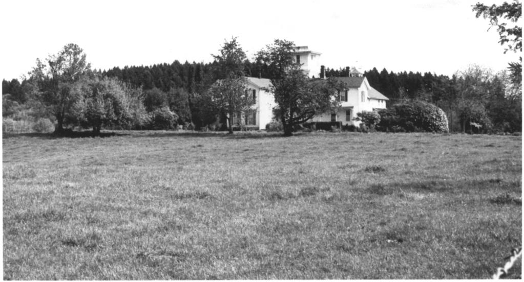
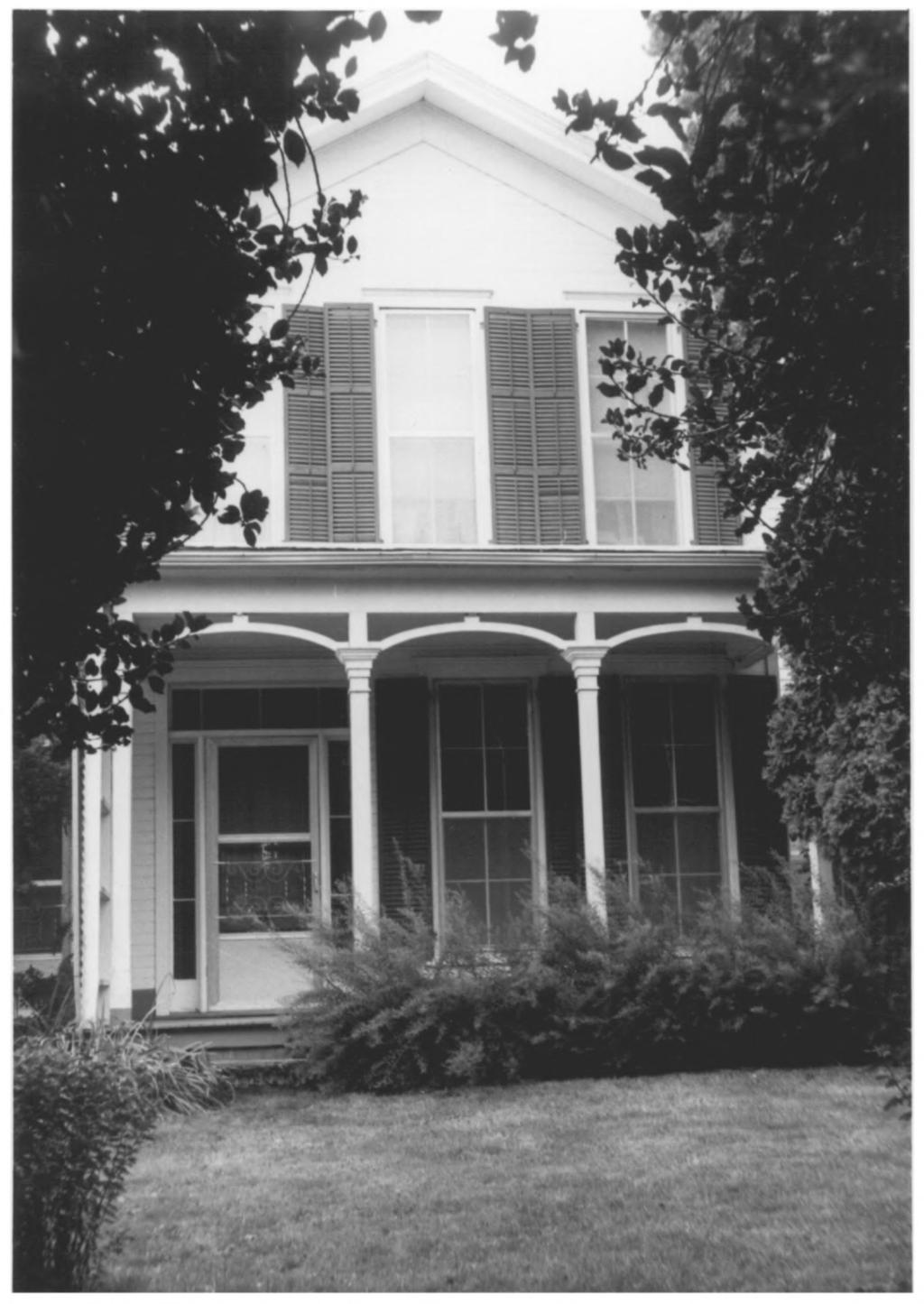
2 7. Description Condition excellent -KXgood, fair deteriorated ruins unexposed Check one unaltered XX altered Check one xx original site moved date Describe the present and original (iff known) physical appearance Originally constructed in , the Casper Zorn Farmhouse combined elements of vernacular and Southern Greek Revival styles. The formal, axial massing of the original structure and the elegant exterior proportions and detailing probably resulted from John Hoefer, who, with Casper Zorn, built the house. Hoefer spent two years in New Orleans prior to moving to Oregon in The house stands in a totally rural setting on the brow of a small hill on the south side of Champoeg Road NE, Marion County, Oregon, overlooking the road and Champoeg State Park to the north. A 450'-long driveway lined on one side with locust trees leads from the road to the home site. The house and the four-story windmill tower beside it are visible both from the road and the campground at Champoeg State Park, which formerly was a part of the Zorn Farm. Consisting of 14 rooms, it is 80* long (including a 6%-foot deep front porch) and is of varying widths from 20' (including the 6%-foot wide and 42' long veranda) in the dining room area, 35' at the parlor and living room areas, and 49' at the kitchen, pantry and storage room areas in the rear. The house was originally a modified H-style. Two north/south two-story wings were connected in the middle by a one-story wing. In 1880 the structure was enlarged to its present size and appearance. The rear (west) wing of the house was moved laterally to the south. The one-story connecting wing was Increased to two stories and extended to meet the outside (west) wall plane of the moved wing. Thus, the old wing abutted the new on the south elevation of the new, effectively destroying the original gabled end of the old, which became an interior wall. The resulting configuration is ell-shaped. The exterior siding is clapboard except along the walls of the porches, which are tongue-in-groove. The width of the boards on the addition is wider than that of the older wings. The fir lumber used in the construction was produced on the farm. Square, handmade wrought iron nails were used in the construction. Further evidence of the Southern inspiration in the detailing appears in the functioning wooden window shutters. Painted in characteristic dark green, they cover tall, elegant 4 over 4 double hung sash windows which were an indigenous part of domestic architecture of New Orleans at the time Hoefervisited the city. These and other windows in the house are simply framed with shallow cornice moldings. The door in the east (original front) elevation is four-paneled and surrounded on three sides by recessed lights. Three tall singlestack chimneys straddle the roof ridge. Two are still in use. The structure is built on brick pillar foundations which are covered with zinc sheetingto protect the sills from moisture. The porches are flat roofed. The front facade and the living room wing have small porches facing east. A wooden balcony was originally in place above the front elevation porch. The forty-two foot long porch, or veranda, on the north side leads to the living room and is currently used as the main entrance. The rear wing also has a porch running the length of the east side of the wing. The porch supports are turned posts and have ornamental scroll brackets abutting the cornices except for the front elevation, whose delicate scaled posts are connected by undecorated wooden segmental arches. Two of the rooms in the house the parlor and a bedroom still have the original furniture and carpeting placed in the rooms when the house was enlarged in 1880, and the bedroom still has the original wallpaper hung at that time. The parlor furniture is graceful mid-victorian, upholstered in black horsehair. The bedroom furniture includes a
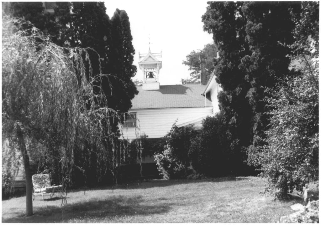
3 FHR-8-300A (11/78) UNITED STATES DEPARTMENT OF THE INTERIOR HERITAGE CONSERVATION AND RECREATION SERVICE NATIONAL REGISTER OF HISTORIC PLACES INVENTORY- NOMINATION FORM Zorn (Casper) Farmhouse CONTINUATION SHEET ITEM NUMBER PAGE 1 marble topped bureau, washstand and commode and the original floral wallpaper in the room is in excellent unfaded condition. The rest of the interior is essentially unaltered with the exception of the kitchen, which has been modernized. The dining room was also renovated around Most of the original wallpaper has been lost. The floors are original. The relocated rear wing was probably used as a bunk house, as it was essentially unfinished until after In 1896 the four story windmill tower was built to provide running water for the house. At the same time the ornate bell cupola housing the dinner bell to call the farm hands from the fields at noon time was added to the roof of the rear wing of the house. Both are essentially in the Queen-Anne style with elaborate Eastlake detailing, especially in the cupola. The windmill is especially remarkable. While this type of functional structure is not unusual in Oregon, it is seldom richly decorated. The free-standing tower measures 20' square at the base. Two identical stories, demarcated by a wide shingled band course terminates in a bracketed cornice. The shingled roof above is broken by highly articulated dormer windows in axial alignment with the lower windows in each elevation. The steeplypitched shingled roof flares out to support the shingled water tank room. Centrally positioned windows are found on three of the four elevations. A delicately scaled balcony surrounds this room. Corner posts support the Italianate cornice. The windmill wheel and blades were destroyed in a hurricane in Due to constant water damage, the interior has substantially deteriorated and is not used. A shed-type garage was added to the south end of the tower at an unknown date. The house has been lived in and maintained in repair continuously and is in excellent condition. It is surrounded by well-kept lawns and garden.

4 8. Significance Period prehistoric OCX Areas of Significance Check and justify below archeology-prehistoric community planning archeology-historic conservation agriculture economics XX architecture education art engineering XX commerce XX exploration/settlement «_ communications. industry invention landscape architecture law literature military music philosophy politics/government Specific dates Builder/Architect John Hoefer and Casper Zorn Statement of Significance (in one paragraph) religion science sculpture social/ humanitarian theater transportation other (specify) Located in an isolated setting, the Casper Zorn House, built between 1867 and 1870, is significant for several reasons: one, it is an excellently preserved document in the history of one of Oregon's pioneer families; two, it is associated with the politically and economically significant Champoeg area; and three, it is an excellent example of how an Eastern architectural vocabulary was transferred to Oregon and modified to suit local conditions. Additionally, the four-story windmill tower is one of the largest and most elaborately detailed examples of thfs diminishing type in the State of Oregon. The house is prominently positioned overlooking Champoeg State Park. Located next to the banks of the Willamette River, the community of Champoeg was an important early commercial center. It was an outpost for the Hudson's Bay Company as well as the site of assemblages in 1843 which created the Provfsional Government of Oregon and first written Constitution. Champoeg was destroyed in 1861 by a disastrous flood, rebuilt, destroyed again in 1890, and subsequently abandoned. John Hoefer, a cabinet maker and carpenter in his youth, lived two years in New Orleans before coming to Oregon in Casper Zorn, Hoefer 's future partner and brother-in-law, also passed through New Orleans. He traveled to Panama from there and crossed the Isthmus, arriving in Oregon in Undoubtedly the two men were exposed to various types of Southern Revival architecture, as elements of this architecture appear in the Zorn House. The two pioneers lived in the Champoeg area from the time of their arrival in Oregon. By 1862, the year after the first flood, they were part owners of the Champoeg Flour and Grist Mill, the first grist mill south of the Columbia River. Robert Newell, important Champoeg pioneer and major land owner, left the area in After his departure, the various parcels into which his land claim had been divided were accumulated by the two men. By the time of John Hoefer 's death in 1909, nearly all of the original Newell claim (640 acres) was owned by the two men. They sold the mill in 1876, but repurchased it after the 1890 flood. The reconstructed structure continued to be used until approximately In 1901, Hoefer and Zorn deeded "one rod square" to the Oregon Historical Society for the purpose of allowing them to erect a granite monument commemorating the site of the original vote to establish the Provisional Government. This deed was extended by 2.19 acres in 1906 and subsequently added to through sales to the State by the Zorn heirs, creating what is now Champoeg State Park. The size of the Zorn house increased with the prosperity of the two men. The 1880 addition created an imposing structure of 14 rooms. The prominence of the building was further enhanced by the equally inspiring windmill tower of Adding to this significance of the house are two of the rooms, the parlor and a bedroom, furnished with the original furniture placed in the rooms when the house was remodeled a century ago. The parlor is furnished with black horsehair upholstered chairs and settee and the floor is covered with flooral design old fashioned carpeting. A large square piano, traditionally reputed to have once belonged to Governor Gibbs, the second governor of Oregon, dominates the room. The bedroom is furnished with "Lincoln" type Victorian furniture, and the original floral wallpaper hung at that time is still in excellent unfaded condition.
 Quadrangle name St.")
5 9. Major Bibliographical References Corning, Howard M. Dictionary of Oregon History. Portland: Binsford & Mort, Zorn Family Farm History Notes written by Henry Zorn ), unpublished. Illustrated Historical Atlas Nap Marion and Linn Counties, by Edgar Williams.& Co. M878K 10. Geographical Data Acreage of nominated property less tbad_one (.79 acre) Quadrangle name St. Paul UMT References A ll iq I I5l0i9l0i3 i5l l5 10 ll 10 Ip ll lo I Zone Easting Northing c I I I, I, i I I i I i I i i I b Zone 1 1, 1,, Easting D, 1 1 1,,, 1 Northing I I El. I I I. I I I I I Fl, 1 1 1, I i Gl, I I I. I.. I I i I i I I I I Hi, I I I. I,, I I i I i I i i Verbal boundary description and justification Beginning at a point where the driveway leading to the Zorn House intersects the south boundary of Champoeg Road NE, in Sec. 1, T4S, R2W 9 W.M., Marion County, Oregon, running thence southerly along the east boundary line fence of the driveway a distance of 450' to a wooden post, the true point of beginning; (see continuation List all states and counties for properties overlapping state or county boundaries sheet) state code county code state code county code 11. Form Prepared By name/title < Gather? ne- Zorn organization date September 7, 1979 street & number 8448 Champoeg Rd. telephone 503/ or city or town St. Paul state Oregon State Historic Preservation Officer Certification The evaluated significance of this property within the state/s: X national state local As the designated State Historic Preservation Offida for the National Historic Preservation Act of 1966 (Public Law ), I hereby nominate this property for inclusion/i National Register and certify that it has been evaluated according to the criteria and procedures set forth ritage Conservation and Recreation Service. State Historic Preservation Officer signature title SHPO Designee date December 18, 1979 I hereby certify that this property is included in tre National Register eeper of the National Register Attest: GPO
6 FHR-8-300A (11/78) UNITED STATES DEPARTMENT OF THE INTERIOR HERITAGE CONSERVATION AND RECREATION SERVICE NATIONAL REGISTER OF HISTORIC PLACES INVENTORY- NOMINATION FORM Zorn (Casper) House CONTINUATION SHEET ITEM NUMBER 8 PAGE 1 The garden surrounding the home contains two rows of white sweetwater grapes planted when the house was built and a collection of old fashioned roses. The grape vines are in vigorous condition and still bear fruit. Some of the roses date back to the original bushes and others have been collected in friendship garden fashion.
7 FHR-8-300A (11/78) UNITED STATES DEPARTMENT OF THE INTERIOR HERITAGE CONSERVATION AND RECREATION SERVICE NATIONAL REGISTER OF HISTORIC PLACES INVENTORY - NOMINATION FORM Zorn (Casper) Farmhouse CONTI NUATION SHEET ITEM NUMBER PAGE Hussey, John A. Champoeg; Place of Transition. Portland: Oregon Historical Society, 1967
8 FHR-8-300A (11/78) UNITED STATES DEPARTMENT OF THE INTERIOR HERITAGE CONSERVATION AND RECREATION SERVICE NATIONAL REGISTER OF HISTORIC PLACES INVENTORY -- NOMINATION FORM Zorn (Casper) Farmhouse CONTI NU ATION SHEET ITEM NUMBER ]Q PAGE ] thence running easterly a distance of 255'; thence southerly 125'; thence westerly 275'; thence northerly 125'; thence easterly 20' to the true point of beginning, containing.79 acres, more or less, comprising the grounds presently fenced in surrounding the Zorn House.
9 o z, -4 r- rn 1. N w k * re a w HOUSE PLAN SCALE: 1" - 20' ZORN (CASPER) FARMHOUSE, CHAMPOEG, MARION COUNTY, OREGON
10

11 Zorn (Casper) Farmhouse St. Paul, Marion Co., Oregon 1 of 8 FEB i 2!9bU Elisabeth Potter photo, 1979 State His Pres Office 525 Trade St. SE S^alem, OR JAN ± View of east elevation from Champoeg Road


12

13 Zorn (Casper) Farmhouse St. Paul, Marion Co, Oregon 2 of 8--view of site from the north FEB I 2 m Elisabeth Potter photo, 1979 State Historic Pres Office 525 Trade St. SE Salem, OR JAN j


14

15 Zorn (Casper) Farmhouse St. Paul, Marion Co, Oregon Elisabeth Potter photo, 1979 State His. Preservation Office 525 Trade St. SE Salem, OR 3 of 8 -- View of site from the northwest p g j >
16

17 ZORN HOUSE - Gable facade facing east. Photographed ty Catherine Zorn, 8/19/79- FEB 1 2 Zorn (Casper) Farmhouse St. Paul, Marion Co, Oregon Catherine Zorn photo, 1979 St. Paul, OR JAH of 8 -- View of east (origi nal front) elevation

18

19 ZORN HOUSE - North and west sides Photographed by Catherine Zorn, 8/19/79 JAN 1 4 tttt) Zorn (Casper) Farmhouse St. Paul, Marion Co, Oregon Catherine Zorn photo, 1979 St. Paul, OR FEB I of 8 -- View of north elevation


20
 Farmhouse St. Paul, Marion Co, Oregon Catherine Zorn photo, 1979 St.")
21 ZOEN HOUSE - South and east sides of house and wind mill tower. Photographed by Catherine Zorn, 8/19/79. JAN ^ Zorn (Casper) Farmhouse St. Paul, Marion Co, Oregon Catherine Zorn photo, 1979 St. Paul, OR FEB of 8 -- View of windmill from the southwest
22
 House St. Paul, Marion Co, Oregon Catherine Zorn photo, 1979 St.")
23 20RN H3USE - East side of rear wing. Photographed by Catherine Zorn, 8/19/79 FEB ' 2 98 JAM Zorn (Casper) House St. Paul, Marion Co, Oregon Catherine Zorn photo, 1979 St. Paul, OR of 8 -- View of rear wing (east elevation)

24

25 ZORN HOUSE - Detail of bell cupola* Photographed by Catherine Zorn, 8/19/79 I 2 om JAN Zorn (Casper) House St. Paul, Mario/i Co., Oregon Catherine Zorn photo, 1979 St. Paul, OR of 8 -- Detail of belvedere, rear wing
NPS Form OMB No Exp Status occupied X unoccupied work in progress Accessible yes: restricted yes: unrestricted _5Lno
 NPS Form 10-900 OMB No. 1024-0018 Exp. 10-31-84 United States Department of the Interior National Park Service National Register of Historic Places Inventory Nomination Form See instructions in How to
3. Classification. 5. Location of Legal Description. 6. Representation in Existing Surveys
 N~~ Form 10.900 (382) OMB No. 10240018 Exp. 103164 United States Department of the Interior National Park Service National Register of Historic Places InventoryNomination Form See instructions in How to
TYPE ALL ENTRIES -- COMPLETE APPLICABLE SECTIONS. Elsenhower Memorial Chapel (unofficially)
") Form No 10-306 (Rev 10-74) UNlTEDSTATtS DEPARTMENT OK THt INTERIOR NATIONAL PARK SERVICE NATIONAL REGISTER OF HISTORIC PLACES INVENTORY - NOMINATION FORM FOR FEDERAL PROPERTIES SEE INSTRUCTIONS IN HOW
Form No 10-306 (Rev 10-74) UNlTEDSTATtS DEPARTMENT OK THt INTERIOR NATIONAL PARK SERVICE NATIONAL REGISTER OF HISTORIC PLACES INVENTORY - NOMINATION FORM FOR FEDERAL PROPERTIES SEE INSTRUCTIONS IN HOW
CJheck one original s ite moved date
 FHR-8-300 (11-78) United States Department off the Interior Heritage Conservation and Recreation Service National Register of Historic Places Inventory Nomination Form See instructions in How to Complete
National Register off Historic Places received NOV U 1985 Inventory Nomination Form date ante** DEC j 2 BBS
 NPS Form 10400 042) 0MB No. 1024-0018 Exp. 10-31-84 United States Department off the Interior National Park Service For NFS us* only National Register off Historic Places received NOV U 1985 Inventory
3. Classification -- Category Ownership Status Present Use
 United States Department of the Interior National Park Service?htbn~! Register of klkt~rk Places For HPS UM only received Inventory-Nomination Form date entered See instructions in How to Complete National
- - CITY. TOWN CONGRESSIONAL DISTRICT. Princeton, VICINITY OF. STATE CODE COUNTY CODE West Virginia 54 Mercer 055
 UNITtD S DEPAKTMkNT OF THE IN1 EKIOR NATIONAL PARK SERVICE NATIONAL REGISTER OF HISTORIC PLACES INVENTORY -- NOMINATION FORM NAME HISTORIC AND/OR COMMON SEE INSTRUCTIONS IN HOW TO COMPLETE NATIONAL REGISTER
Places state West Virginia code county Marion
 NPS Form 1W0 csaa, United States Department of the lnteria? National Park Service National Register of Historic Inventory-Nomination Form See instructions in How to Complete National Register Forms Type
National Register of Historic Places received 9 Inventory Nomination Form date entered M/W 9 I9S
 NPS Form 10-900 0MB No. 1024-0018 (3-82) Exp. 10-31-84 For NPS use only National Register of Historic Places received 9 Inventory Nomination Form date entered M/W 9 I9S See instructions in How to Complete
Maryland Historical Trust Inventory No. 15/6 Maryland Inventory of Historic Properties Form
 Inventory No. 15/6 Maryland Inventory of 1. Name of Property (indicate preferred name) historic Becraft Farm other 2. Location street and number 28500 Ridge Road not for publication city, town Mount Airy
Maryland Historical Trust Inventory No. PG: 86A-026 Maryland Inventory of Historic Properties Form
 Inventory No. PG: 86A-026 Maryland Inventory of 1. Name of Property (indicate preferred name) historic other 2. Location street and number 12811 Croom Road not for publication city, town Naylor vicinity
SEE INSTRUCTIONS IN HOWTO COMPLETE NATIONAL REGISTER FORMS TYPE ALL ENTRIES - COMPLETE APPLICABLE SECTIONS NAME VICINITY OF CODE STATUS
 Form No. 10-300 ^ \Q- UNITED S DEPARTMENT OF THE INTERIOR NATIONAL PARK SERVICE NATIONAL REGISTER OF HISTORIC PLACES INVENTORY -- NOMINATION FORM SEE INSTRUCTIONS IN HOWTO COMPLETE NATIONAL REGISTER FORMS
Langley Register of Historic Places Nomination Form
 FOR OFFICE USE ONLY Langley Register of Historic Places Nomination Form Received Type all entries 1. Name of Property Historic: Jacob Anthes Bunkhouse/Cookhouse And/or common: South Whidbey Historical
Status occupied unoccupied work in progress Accessible yes: restricted _X-_ yes: unrestricted no. Jackson County Courthouse
 NPS Form 10-900 (3-82) OMB No. 1024-0018 Exp. 10-31-84 United States Department of the Interior National Park Service National Register of Historic Places Inventory Nomination Form See instructions in
THE CORPORATION OF THE TOWN OF NIAGARA-ON-THE-LAKE. BY-LAW NO (214 Four Mile Creek Road)
") THE CORPORATION OF THE TOWN OF NIAGARA-ON-THE-LAKE BY-LAW NO. 4807-15 (214 Four Mile Creek Road) A BY-LAW TO DESIGNATE THE PROPERTY KNOWN MUNICIPALLY AS WOODBOURNE, 214 FOUR MILE CREEK ROAD, IN THE TOWN
THE CORPORATION OF THE TOWN OF NIAGARA-ON-THE-LAKE BY-LAW NO. 4807-15 (214 Four Mile Creek Road) A BY-LAW TO DESIGNATE THE PROPERTY KNOWN MUNICIPALLY AS WOODBOURNE, 214 FOUR MILE CREEK ROAD, IN THE TOWN
National Register of Historic Places Inventory Nomination Form
 NPS Form 10-900-a Exp. 10-31-84 Continuation sheet 4 5 item number 7 Page 45 NAME: Knight Estate LOCATION: 486 East Avenue,,--v..u^-^ OWNER: State of Rhode Island Department of Education Board of Regents
Address 347 Whitney Street. East elevation, camera facing southwest.
 FORM B BUILDING Assessor s Number USGS Quad Area(s) Form Number MASSACHUSETTS HISTORICAL COMMISSION MASSACHUSETTS ARCHIVES BUILDING 220 MORRISSEY BOULEVARD BOSTON, MASSACHUSETTS 02125 Town Northborough
 Page 1 Original Update HISTORICAL STRUCTURE FORM FLORIDA MASTER SITE FILE Consult Guide To Historical Structure Forms for detailed instructions Site # 8OR9844 Recorder # 26 Recorder Date 2/20/08 Site Name
301 7½ Street SW
 301 7½ Street SW 104-0213-0072 Primary Resource Information: Single Dwelling, Stories 2.00, Style: Other, ca 1890 July 2006: This late-19th-century, 3-bay, 2-story, hip-roofed frame I-house features projecting
Town: Sharon Place (neighborhood or village): Sharon. ame of Area: Present Use: Date (month / year): July 2008
: Sharon. ame of Area: Present Use: Date (month / year): July 2008") FORM A - AREA MASSACHUSETTS HISTORICAL COMMISSION MASSACHUSETTS ARCHIVES BUILDING 220 MORRISSEY BOULEVARD BOSTON, MASSACHUSETTS 02125 Photograph Assessor s Sheets USGS Quad Area Letter Form Numbers in
FORM A - AREA MASSACHUSETTS HISTORICAL COMMISSION MASSACHUSETTS ARCHIVES BUILDING 220 MORRISSEY BOULEVARD BOSTON, MASSACHUSETTS 02125 Photograph Assessor s Sheets USGS Quad Area Letter Form Numbers in
National Register of Historic Places Inventory-Nomination Form. I. Name. 5. Location of Lesal Descri~tion
 United States Department of the Interior National Park Service National Register of Historic Places Inventory-Nomination Form See instructions in How to Complete National Register Forms Type all entries-complete
Maryland Historical Trust Inventory No. PG: 86A-003 Maryland Inventory of Historic Properties Form
 Inventory No. PG: 86A-003 Maryland Inventory of 1. Name of Property (indicate preferred name) historic other 2. Location street and number 12005 Duley Station Road not for publication city, town Upper
THE BARNACLE 3485 MAIN HIGHWAY
 THE BARNACLE 3485 MAIN HIGHWAY Designation Report City of Miami REPORT OF THE CITY OF MIAMI PLANNING AND ZONING DEPARTMENT TO THE HISTORIC AND ENVIRONMENTAL PRESERVATION BOARD ON THE POTENTIAL DESIGNATION
Intensive Level Historic Resources Survey 5.0 ANNOTATED LIST OF PROPERTIES
 Intensive Level Historic Resources Survey 5.0 ANNOTATED LIST OF PROPERTIES CBCA PN 05-012A May 2009 Photo Location Description 10760 Bodine Road Date: 1811 Historic addition of side block to the rear;
6. Representation in Existing Surveys. National Register of Historic Places Inventory Nomination Form. 1. Name. 2. Location. 3.
 FHR-8-300 (11-78) United States Department of the Interior Heritage Conservation and Recreation Service National Register of Historic Places Inventory Nomination Form See instructions in How to Complete
Commonwealth of Massachusetts Massachusetts Historical Commission 220 Morrissey Boulevard, Boston, Massachusetts
 Inventory No: Historic Name: Common Name: Address: HRV.165 Blood, Joseph House Farnsworth, Jonathan - Beaman, Jonathan House 74 Poor Farm Rd City/Town: Village/Neighborhood: Local No: 9-17 Year Constructed:
Status X occupied unoccupied X work in progress Accessible X yes: restricted - yes: unrestricted np. Clackamas County Courthouse.
 NFS Form 10-900 (3-82) United States Department of the Interior National Park Service National Register of Historic Places Inventory Nomination Form See instructions in How to Complete National Register
Seaforth Walking Tour
 Seaforth Walking Tour 1: Victoria Park The land for Victoria Park was donated to the Town by Dr. William Gouinlock in 1875, (one year after Seaforth was officially incorporated). The bandshell was constructed
National Register of Historic Places Inventory Nomination Form. 1. Name. 2. Location. 3. Classification. 4. Owner of Property
 NFS Form 10-900 (3-82) 0MB No. 1024-0018 Expires 10-31-87 United States Department of the Interior National Park Service National Register of Historic Places Inventory Nomination Form See instructions
SEE INSTRUCTIONS IN HOWTO COMPLETE NATIONAL REGISTER FORMS TYPE ALL ENTRIES - COMPLETE APPLICABLE SECTIONS NAME VICINITY OF CODE STATUS
 Form No. 10-300, \Q-1 \&V UNITED STATES DEPARTMENT OF THE INTERIOR INVENTORY - NOMINATION FORM SEE INSTRUCTIONS IN HOWTO COMPLETE NATIONAL REGISTER FORMS TYPE ALL ENTRIES - COMPLETE APPLICABLE SECTIONS
Maryland Historical Trust Inventory No. PG: 75A-007 Maryland Inventory of Historic Properties Form
 Inventory No. PG: 75A-007 Maryland Inventory of 1. Name of Property (indicate preferred name) historic other 2. Location street and number 3101 Ritchie Road not for publication city, town Forestville vicinity
808 Cherry Avenue
 808 Cherry Avenue 104-0213-0059 Primary Resource Information: Single Dwelling, Stories 2.00, Style: Other, ca 1900 July 2006: This 2-story, 3-bay frame I-house features a central-front gable, a brick pier
Maryland Historical Trust Inventory No. PG: 81B-008 Maryland Inventory of Historic Properties Form
 Maryland Historical Trust Inventory No. PG: 81B-008 Maryland Inventory of 1. Name of Property (indicate preferred name) historic other 2. Location Dyson Farmhouse (preferred) street and number 13010 Piscataway
STATE CODE COUNTY CODE West Virginia 54 Greenbrier 025 STATUS ZOCCUPIED -UNOCCUPIED -WORK IN PROGRESS ACCESSIBLE YES: RESTRICTED
 "orm No. 10300 (Rev. 10741., US1TED STlITES DEPARTMENT OF THE INTERIOR NATIONAL PARK SERVICE FOR NPS USE ONLY NATIONAL REGISTER OF HISTORIC PLACES RECEtVEQ,/, INVENTORY NOMINATION FORM,., d' >A; 4y.. y
National Register of Historic Places Registration Form
 NPS Form 10-900 OMB No. 10024-0018 (Oct. 1990) United States Department of the Interior National Park Service National Register of Historic Places Registration Form 1. Name of Property historic name Hickory
Maryland Historical Trust Inventory No. PG: Maryland Inventory of Historic Properties Form
 Inventory No. PG: 62-012 Maryland Inventory of 1. Name of Property (indicate preferred name) historic other 2. Location street and number 11205 Old Baltimore Pike not for publication city, town Beltsville
NPS Form (3-82) OMB No Expires
 OMB No Expires") NPS Form 10-900 (3-82) OMB No. 1024-0018 Expires 10-31-87 United States Department of the Interior National Park Service National Register of Historic Places Inventory Nomination Form See instructions
NPS Form 10-900 (3-82) OMB No. 1024-0018 Expires 10-31-87 United States Department of the Interior National Park Service National Register of Historic Places Inventory Nomination Form See instructions
MINNESOTA HISTORIC.PROPERTIES INVENTORY FORM. Yes_ No X Restricted
 HISTORIC NAME: CURRENT NAME: LEGAL DESC.: MINNESOTA HISTORIC.PROPERTIES INVENTORY FORM Hartley Sugar Camp W % of Gov't. Lot 3 and T55, R24, Sec. 9 COUNTY: Itasca CITY/TWP.: Trout Lake Twp. ADDRESS: of
DESIGNATION REPORT KENNEDY-BAKER-WALKER-SHERRILL HOUSE (1849) 9320 KINGSTON PIKE (CLT ) KNOXVILLE, TENNESSEE July 12, 2007
 9320 KINGSTON PIKE (CLT ) KNOXVILLE, TENNESSEE July 12, 2007") DESIGNATION REPORT KENNEDY-BAKER-WALKER-SHERRILL HOUSE (1849) 9320 KINGSTON PIKE (CLT 132-027) KNOXVILLE, TENNESSEE July 12, 2007 Description The Kennedy-Baker-Walker-Sherrill House is located on the south
DESIGNATION REPORT KENNEDY-BAKER-WALKER-SHERRILL HOUSE (1849) 9320 KINGSTON PIKE (CLT 132-027) KNOXVILLE, TENNESSEE July 12, 2007 Description The Kennedy-Baker-Walker-Sherrill House is located on the south
Current Functions (Enter categories from instructions) Materials (Enter categories from instructions)
 Materials (Enter categories from instructions)") Site Inventory Form State Inventory No. 92-00542 New Supplemental State Historical Society of Iowa Part of a district with known boundaries (enter inventory no.) 92-00349 (November 2005) Relationship:
Site Inventory Form State Inventory No. 92-00542 New Supplemental State Historical Society of Iowa Part of a district with known boundaries (enter inventory no.) 92-00349 (November 2005) Relationship:
"The Stone House;" Parker Family Residence; Slosn, Richard, House. Route 50 approximately 314 mile east of Junction
 Form No. 10300 (Rev. 1074) UNITED STATES DEPARTMENT OF THE INTERIOR NATIONAL PARK SERVICE NATIONAL REGISTER OF HISTORIC PLACES INVENTORY NOMINATXON FORM @NAME HISTORIC SEE INSTRUCTIONS IN HOW TO COMPLETE
SURVEY OF PUBLIC HOUSES WESTON TURVILLE
 BUCKINGHAMSHIRE ARCHAEOLOGICAL SOCIETY HISTORIC BUILDINGS GROUP SURVEY OF PUBLIC HOUSES IN THE PARISH OF WESTON TURVILLE BUCKINGHAMSHIRE A record of extant buildings that are currently or were formerly
THE CHATHAM-KENT MUNICIPAL HERITAGE REGISTER
 THE CHATHAM-KENT MUNICIPAL HERITAGE REGISTER Listed Properties in the Community of Tilbury Photo Credit: W.J. Bolton/Canada. Dept. of Manpower and Immigration/Library and Archives Canada/PA-031135, 1923-1924
500 Preston Place. Garages PRESENT USE: Garages PRESENT OWNER: Preston Court Limited Partnership ADDRESS:
 PRESTON PLACE 500 Preston Place STREET 500 Preston Place MAP & PARCEL: 5-116 Garages Garages PRESENT OWNER: Preston Court Limited Partnership 413 7 th Street NE Charlottesville, Va. 22902 DATE/ PERIOD:
Commonwealth of Massachusetts Massachusetts Historical Commission 220 Morrissey Boulevard, Boston, Massachusetts
 Inventory No: Historic Name: Common Name: Address: HRV.173 Rand, Jonathan House and Farm Taylor, William Jr. - Barnard, Ephraim House 44 Littleton County Rd City/Town: Village/Neighborhood: Local No: 23-20,21
United States Department of the Interior National Park Service NATIONAL REGISTER OF HISTORIC PLACES REGISTRATION FORM. Wilmoth, Bernard E.
 NPS Form 10-900 OMB No. 10024-0018 (Oct. 1990) United States Department of the Interior National Park Service NATIONAL REGISTER OF HISTORIC PLACES REGISTRATION FORM 1. Name of Property historic name: other
Maryland Historical Trust Inventory No Maryland Inventory of Historic Properties Form
 Inventory No. 15 28 Maryland Inventory of 1. of Property (indicate preferred name) historic Luther Moore Farm other 2. Location street and number 7201 Damascus Road not for publication city, town Gaithersburg
Type of Building. By-law
 1 2-2-storey frame house on stone rubble foundation. - Built by Mead - "Ontario " plan. - Centred gable with arched window in gable. Meads 202 John Plan 20, Part Lot 20 1895 Residence - Shutters on the
OR THEMATIC NOMINATION. STREET & NUMBER W side of SR l48s, 1.S mil. N of Muddy Creek _N()T FOR PUBLICATION CITY, TOWN. CONGRESSIONAL DISTRICT Arcadia
T FOR PUBLICATION CITY, TOWN. CONGRESSIONAL DISTRICT Arcadia") _--..,""'-"-_""-""- COUNTY xx::.c...- MULTIPLE RESOURCE OR THEMATIC NOMINATION HISTORIC Hampton House STREET & NUMBER W side of SR l48s, 1.S mil. N of Muddy Creek _N()T FOR PUBLICATION CITY, TOWN CONGRESSIONAL
_--..,""'-"-_""-""- COUNTY xx::.c...- MULTIPLE RESOURCE OR THEMATIC NOMINATION HISTORIC Hampton House STREET & NUMBER W side of SR l48s, 1.S mil. N of Muddy Creek _N()T FOR PUBLICATION CITY, TOWN CONGRESSIONAL
6. Representation in Existing Surveys. National Register of Historic Places Inventory Nomination Form. 1. Name. 4. Owner of Property !
 NPS Form 10-900 (3-82) OMB No. 1024-0018 Exp. 10-31-84 United States Department of the Interior National Register of Historic Places See instructions in How to Complete National Register Forms Type all
1 Gildersleeve Wood (DHR # )
") GILDERSLEEVE WOOD 1 Gildersleeve Wood (DHR # 104-5092-0012) STREET ADDRESS: 1 Gildersleeve Wood MAP & PARCEL: 11-20 PRESENT ZONING: R-1U ORIGINAL OWNER: Lindsay Family ORIGINAL USE: PRESENT USE: PRESENT
GILDERSLEEVE WOOD 1 Gildersleeve Wood (DHR # 104-5092-0012) STREET ADDRESS: 1 Gildersleeve Wood MAP & PARCEL: 11-20 PRESENT ZONING: R-1U ORIGINAL OWNER: Lindsay Family ORIGINAL USE: PRESENT USE: PRESENT
street & number: COUNTY ROUTE 3, HC-88, BOX 17 not for publication: N/A city/town: WHEELER vicinity: X state: WV county: WEBSTER code: 101 zip code:
 NPS Forn 10-900 OMB No. 10024-0018 (Oct. 1990) United States Department of the Interior National Park Service NATIONAL REGISTIR OF HISTORIC PLACES REGISTRATICN FCRX =========================================================---------=======
NE¼ of NE¼ of NE¼ of NE¼ of section Roof configuration (enter one): Gabled Roof / Front Gabled Roof
: Gabled Roof / Front Gabled Roof") OAHP1403 Rev. 9/98 COLORADO CULTURAL RESOURCE SURVEY Official Eligibility Determination (OAHP use only) Date Initials Determined Eligible - National Register Architectural Inventory Form Determined Not
OAHP1403 Rev. 9/98 COLORADO CULTURAL RESOURCE SURVEY Official Eligibility Determination (OAHP use only) Date Initials Determined Eligible - National Register Architectural Inventory Form Determined Not
NPS Form OMB No Exp Nevada-Callform'a-Oregon Railway Passenger Station
 NPS Form 10-900 OMB No. 1024-0018 Exp. 10-31-84 United States Department off the Interior National Park Service National Register of Historic Places Inventory Nomination Form See instructions in How to
- vicinity of. Status. Present Use. occupied agriculture A!- museum t -L structure - both - work in progress - educational private residence
 Unitad States Department of the Interior - National Park Service - ational Register of Historic Places -- - inventory-nomination Form See instructions in How to Complete National Register Forms Type all
National Register off Historic Places Inventory Nomination Form
 NPS Fomi ia-900-a OMB Ho. 1024-0018 Exp. 10-31-S4 United States Department of the Interior National Park Service National Register off Historic Places Inventory Nomination Form For HPS UM only received
ate: AR County: Pulaski Code: AR Zip Code: Noncontributing buildings sites structures objects Total
 Mims-Ereedlove-Priest-Weatherton House Name of Property Little Rock, AR County and State ~- -,s Form 10-900 'V. 8-86) OMB No. 1024-0018 United States Department of the Interior National Park Service NATIONAL
National Register of Historic Places Registration Form
 NPS Form 10-900 OMB No. 1024-0018 (Rev. 10-90) United States Department of the Interior National Park Service National Register of Historic Places Registration Form 1. Name of Property historic name Newcomer
Architectural Inventory Form
 OAHP1403 Rev. 9/98 COLORADO CULTURAL RESOURCE SURVEY Architectural Inventory Form Official eligibility determination (OAHP use only) Date Initials Determined Eligible- NR Determined Not Eligible- NR Determined
ADDENDUM. Chain of Title. Block C, Lot 8-9. Adrian I. Velthuis and Floyd T. Grant to Lottie Thompson
 Chain of Title Block C, Lot 8-9 NLP 5175:842 October 18, 1979 NLP 4979:58 October 5, 1977 NLP 4763:448 May 11, 1977 Adrian I. Velthuis and Floyd T. Grant to Lottie Thompson Gentlemens II Properties, Inc.,
United States Department of the Interior National Park Service. Boundary Expansion Listed in National Register January 11, 2017
 NPS Form 10900-a (Rev. 8/2002) OMB No. 10240018 United States Department of the Interior National Park Service Boundary Expansion Listed in National Register January 11, 2017 National Register of Historic
Appendix E Historic Property Inventory Forms
 Appendix E Historic Property Inventory Forms TECHNICAL MEMORANDUM Sound Transit Federal Way Link Extension WISAARD Survey Entries PREPARED FOR: COPY TO: PREPARED BY: Sound Transit Alisa Swank/ CH2M MaryNell
United States Department of the Interior National Park Service NATIONAL REGISTER OF HISTORIC PLACES REGISTRATION FORM
 NPS Form 10-900 (Oct. 1990) OMB No. 10024-0018 United States Department of the Interior National Park Service NATIONAL REGISTER OF HISTORIC PLACES REGISTRATION FORM 1. DR JOHN C. IRONS RESIDENCE hlstoric
National Register of Historic Places Registration Form
 NPS Form 10-900 OMB No. 10024-0018 (Oct. 1990) Registration Form This form is for use in nominating or requesting determinations for individual properties and districts. See instructions in How to Complete
NATIONAL REGISTER OF HISTORIC PLACES REGISTRATION FORM
 (Rev. 10-90) NPS Form 10-900 OMB No. 1024-0018 NATIONAL REGISTER OF HISTORIC PLACES REGISTRATION FORM This form is for use in nominating or requesting determinations for individual properties and districts.
about 1% miles south of Lahmansville STATE CODE COUNTY CODE West Virginia 5 4 Grant 023 X_OCCUPIED -BEING CONSIDERED -YES: UNRESTRICTED -NO
 Furm No. 10300 (Rev. 10.74) UNITED S DLPARTXIENT OF TIIE INTERIOR NATIONAL PARK SERVICE NATIaNAE REGISTER OF HSTORIC I? LACES INVENTORY NCIMINATICIET FORM I/Lkmm w NAME SEE INSTRUCTIONS IN HOW TO COMPLETE
Town. Place (neighborhood or village) Address. Source. Style/Form. Foundation. Wall/Trim. Roof. Condition. Acreage. Setting
 Address. Source. Style/Form. Foundation. Wall/Trim. Roof. Condition. Acreage. Setting") FORM B BUILDING MASSACHUSETTS HISTORICAL COMMISSION Photograph Assessor s Number USGS Quad Area(s) Form Number 077005 Cotuit E 22 Town Barnstable Place (neighborhood or village) Address 3600 Falmouth Road/Route
FORM B BUILDING MASSACHUSETTS HISTORICAL COMMISSION Photograph Assessor s Number USGS Quad Area(s) Form Number 077005 Cotuit E 22 Town Barnstable Place (neighborhood or village) Address 3600 Falmouth Road/Route
STATE OF IOWA. Historical and Architectural Survey for 2008 Flood Projects in Vinton, Benton County
 STATE OF IOWA CHESTER J. CULVER GOVERNOR PATTY JUDGE LT. GOVERNOR DEPARTMENT OF PUBLIC DEFENSE IOWA HOMELAND SECURITY AND EMERGENCY MANAGEMENT DIVISION DAVID L. MILLER, ADMINISTRATOR Historical and Architectural
Chedoke. Statement of Heritage Significance. Appendix B to Report PED13153(a) 1 of 18. Description of Historic Place.
 1 of 18. Description of Historic Place.") 1 of 18 Chedoke Statement of Heritage Significance Description of Historic Place The building at One Balfour Drive, known as Chedoke, is situated on approximately four acres of land on the Niagara Escarpment
1 of 18 Chedoke Statement of Heritage Significance Description of Historic Place The building at One Balfour Drive, known as Chedoke, is situated on approximately four acres of land on the Niagara Escarpment
SEE ATTACHED SHEET. Massachusetts Historical Commission 80 Boylston Street Boston, Massachusetts 02116
 FORMA - AREA Assessor's Sheets USGS Quad Area Letter Form Numbers in Area 153, 64-67, 1 I I I 124,57, 67, 91, I 76-79, 88-9d 650, 651, 9] 6-918, 1230-1241 West residential. commercial. industrial..."onstructiondates
National Register of Historic Places Registration Form
 NPS Form 10-900 OMB No. 10024-0018 (Oct. 1990) United States Department of the Interior National Register of Historic Places Registration Form 1. historic name South Charles Town Historic District other
East and north elevations, camera facing west. Condition Good
 FORM B BUILDING MASSACHUSETTS HISTORICAL COMMISSION MASSACHUSETTS ARCHIVES BUILDING 220 MORRISSEY BOULEVARD BOSTON, MASSACHUSETTS 02125 Assessor s Number USGS Quad Area(s) Form Number Town Northborough
AHPP. LISTED ========================================================================
 NPS Form 10-900 (Rev. 8-86) Jnited States Department of the Interior ational Park Service OMB No. 1024-0018 LISTED NATIONAL REGISTER OF HISTORIC PLACES REGISTRATION FORM AHPP. 1. Historic Name: Bush-Dubisson
FLAGLER WORKER S HOUSE FORT DALLAS PARK S.E. 4 STREET
 FLAGLER WORKER S HOUSE FORT DALLAS PARK 60-64 S.E. 4 STREET Designation Report City of Miami REPORT OF THE CITY OF MIAMI PLANNING DEPARTMENT TO THE HERITAGE CONSERVATION BOARD ON THE POTENTIAL DESIGNATION
National Register of Historic Places Registration Form
 NPS Form 10-900 OMB No. 1024-0018 (Rev. 10-90) United States Department of the Interior National Park Service National Register of Historic Places Registration Form 1. Name of Property historic name Strode-Morrison-Tabler
Appendix D Reevaluation of Structures on Bock House Property
 Appendix D Reevaluation of Structures on Bock House Property Page 1 Original Update HISTORICAL STRUCTURE FORM FLORIDA MASTER SITE FILE Consult Guide To Historical Structure Forms for detailed instructions
CHRONOLOGY & DEVELOPMENT BOUDINOT-SOUTHARD PROPERTY BASKING RIDGE, NJ OF THE
 CHRONOLOGY & DEVELOPMENT OF THE BOUDINOT-SOUTHARD PROPERTY BASKING RIDGE, NJ Elias Boudinot 1740 Elias Boudinot born May 2 in Philadelphia, where his family was a neighbor of Benjamin Franklin. 1760 Boudinot
STATE CODE COUNTY CODE West Virginia 54 Harrison 033
 I UNlTED STATES DEPARTMENT OF THE INTERIOR NATIONAL PARK SERVICE NATIONAL REGISTER OF HISTORIC PLACES INVENTORY -- NOMINATION FORM NAME HISTORIC AND/OR COMMON LOCATION STREET & NUMBER CITY. TOWN SEE INSTRUCTIONS
HB/10/06/003 Camus House, 46 Lisky Rd, Strabane. Foyle Valley
 Asset Ref No. Heritage Type House, Gates, Outbuildings, Walling Including Around Flax Drying Green. Built Post-Medieval house Location OS 6-inch map sheet Townland Parish LCA Foyle Valley ITM Coordinates
REGISTER OF HISTORIC KANSAS PLACES--COVER SHEET. N la' Lot 9 and all of Lots 10,11, and 12 (legal description) Hutchinson, Kansas (RENO)
 Hutchinson, Kansas (RENO)") Inventory Number REGISTER OF HISTORIC KANSAS PLACES--COVER SHEET Name of Property Women's Civic Center Club 1.56- \JGt,t,o - tj-,t.,'f Location 925 N. Main Street (street and number) Hutchinson (city,
Inventory Number REGISTER OF HISTORIC KANSAS PLACES--COVER SHEET Name of Property Women's Civic Center Club 1.56- \JGt,t,o - tj-,t.,'f Location 925 N. Main Street (street and number) Hutchinson (city,
- Mationai jc)egkwr of Hk fork Pkces inven8sery-n;omima2ion Form
egkwr of Hk fork Pkces inven8sery-n;omima2ion Form") .I United States Department of the interior..=-..ty... a- a.iwmcr a,..- > -. Meritage Conservation and Recreation Service For HCRS use only.:- '.' _.,---..,.-- 7.- c* received - me. :*, -,-,-.".a - Mationai
.I United States Department of the interior..=-..ty... a- a.iwmcr a,..- > -. Meritage Conservation and Recreation Service For HCRS use only.:- '.' _.,---..,.-- 7.- c* received - me. :*, -,-,-.".a - Mationai
Abandoned or Vacant; Agricultural; Camp; Other Residential Agriculture; Archaeology, Historic; Architecture; Politics Government; Social History
 Inventory No: Historic Name: HRV.G Civilian Conservation Camp Common Name: Address: City/Town: Village/Neighborhood: Local No: 13-7.01 Year Constructed: Architect(s): Architectural Style(s): Use(s): Significance:
ri. Name historic: Oak Cliff United Methodist Church Date 7/17/97 and! or common:
 [ Dallas Landmark Landmark Nomination Commission Form ri. Name historic: Oak Cliff United Methodist Church Date 7/17/97 and! or common: L2. Location addresses: 541-49 E. Jefferson location! neighborhood:
NATIONAL REGISTER OF HISTORIC PLACES REGISTRATION FORM
 NPS Form 10-900 OMB No. 1024-0018 (Rev. 10-90) United States Department of the Interior National Park Service NATIONAL REGISTER OF HISTORIC PLACES REGISTRATION FORM 1. Name of Property historic name Compton-Johnson
National Register of Historic Places Registration Form
 NPS Form 10-900 OMB No. 10024-0018 (Oct. 1990) United States Department of the Interior National Park Service National Register of Historic Places Registration Form 1. Name of Property historic name other
N/A not for publication city or town : Hillsboro - X vicinity state: West Virginia code: WV countv: Pocahontas code: 075 zip code: 24946
 United States Department of the Interior National Park Service historic name : other nameslsite number : NIA. -.- 2. Location street & number : HC 64. Box 147loff County Road 3 1 on Kyle Beard Road N/A
CITY OF MURFREESBORO HISTORIC ZONING COMMISSION. Regular Meeting June 19, :30 PM, Council Chambers, City Hall
 CITY OF MURFREESBORO HISTORIC ZONING COMMISSION Regular Meeting June 19, 2018 3:30 PM, Council Chambers, City Hall I. Call to Order and determination of a quorum II. Approve Minutes of the Regular Meeting
[GJ RETXESENTATiON IN EXISTING SUBVZYS E~~%LOCATIOM - V~CINETY 84 LEGAL DESCIIIPTION I T~UIOWNER OF PROPERTY --- *
 NATIONAL PARK SERVICE 1 SEE IN STRUCTI 0 N S IN HOW TO COMPLETE NATlONAL REGISTER FORMS TYPE ALL ENTRIES -- COFdlPLETE APPLICABLE SECTIONS I bherty House - AND/OR COMMON STREET & NUMBER 705 Kalvern Avenue
HISTORIC DISTRICT STUDY COMMITTEE REPORT GEORGE FARMSTEAD HISTORIC DISTRICT OAKLAND TOWNSHIP, MICHIGAN
 HISTORIC DISTRICT STUDY COMMITTEE REPORT GEORGE FARMSTEAD HISTORIC DISTRICT OAKLAND TOWNSHIP, MICHIGAN HISTORIC DISTRICT STUDY COMMITTEE REPORT GEORGE FARMSTEAD HISTORIC DISTRICT OAKLAND TOWNSHIP, MICHIGAN
National Register off Historic Places Inventory Nomination Form
 MPS Fonn 10-900-a (3^ United States Department of the Interior National Park Service National Register off Historic Places Inventory Nomination Form For NPS use only received date entered OMB No 1M4-0018
National Register of Historic Places Continuation Sheet
 Section number N/A Page 1 Proposed Amendment to Wichita, Sedgwick County, Kansas The owner of the building at 141 S. Rock Island Avenue requests amendment to the boundaries of the East Douglas Historic
Cross Street Walking Tour
 Cross Street Walking Tour 1. 33 King Street West: Collins Hotel: 1840 s This impressive building was constructed in 1841 by Bernard Collins. The gallery and Greek style portico were built in the 1850 s
Friends Meeting House, Leicester. 16 Queens Road, Leicester, LE2 1WP. National Grid Reference: SK Statement of Significance
 Friends Meeting House, Leicester 16 Queens Road, Leicester, LE2 1WP National Grid Reference: SK 59852 02815 Statement of Significance A meeting house purpose-built on a new site in 1955 and slightly enlarged
APPENDIX K: BUILT HERITAGE AND CULTURAL HERITAGE LANDSCAPES
 APPENDIX K: BUILT HERITAGE AND CULTURAL HERITAGE LANDSCAPES TABLE 1: Built Resources (BHR) and Cultural Heritage Landscapes (CHL) Within and Adjacent to the West Whitby Secondary Plan Area Site # 1. CHL
United States Department of the Interior National Park Service NATIONAL REGISTER OF HISTORIC PLACES REGISTRATION FORM
 NPS Form 10-900 (Oct. 1990) OMB NO. 10024-0018 United States Department of the Interior National Park Service NATIONAL REGISTER OF HISTORIC PLACES REGISTRATION FORM 1. historic name: WEIMER, JAMES HOUSE
United States Department of the Interior National Park Service NATIONAL REGISTER OF HISTORIC PLACES REGISTRATION FORM
 NPS Form 10-900 (Rev. 8-86) OMB No. 1024-0018 United States Department of the Interior National Park Service NATIONAL REGISTER OF HISTORIC PLACES REGISTRATION FORM other name/site number: "Maple Shadows:"
Change dormers and main entry on the river side of the house. Site: 43 Riverbank Road, Block 10 Lot 3
 City of Burlington Historic Preservation Commission Meeting Minutes: December 2, 2015 The City of Burlington Historic Preservation Commission held its regular monthly meeting on Wednesday, December 2,
Cranberry Lake Farm. By Alicia McCullough for the Oakland Township HDC
 Cranberry Lake Farm By Alicia McCullough for the Oakland Township HDC Cranberry Lake Farm s History Cranberry Lake Farm was purchased by Seymour Fletcher in 1837 from the Federal Government. The development
AH pp. I Ti. Nov 7 I) I I y
 I I y") ..------------------------------------------ ------------ - - -- - NPS Form 10-900 (Rev. 8-86) United States Department of the Interior ~a tional Park Service NATIONAL REGISTER OF HISTORIC PLACES REGISTRATION
..------------------------------------------ ------------ - - -- - NPS Form 10-900 (Rev. 8-86) United States Department of the Interior ~a tional Park Service NATIONAL REGISTER OF HISTORIC PLACES REGISTRATION
Smiths Hill House West Farleigh Kent
 Smiths Hill House West Farleigh Kent Smiths Hill House Smiths Hill - ME15 0PQ Offers In The Region Of 1,000,000 (Freehold) For Sale Extensive unlisted 5 bedroom detached farmhouse full of character situated