Dryland Development in the Americas
|
|
|
- Estella Dixon
- 5 years ago
- Views:
Transcription


1 Dryland Development in the Americas Whereof What's Past is Prologue (The Tempest, Act II) James F Reynolds Duke University Nicholas School of the Environment Durham, North Carolina USA Desert Restoration Bites - 6 Tales from 6 Continents COST / Old Royal Naval College / University of Greenwich 8-January-2013 London, United Kingdom

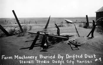
2 THE DUST BOWL chronicles the worst man-made ecological disaster in American history The frenzied wheat boom of the Great Plow-Up followed by a decade-long drought during the 1930s nearly swept away the breadbasket of the nation
")
3 Grassland of the United States Northern Mixed Prairie Shortgrass Steppe Southern Mixed Prairie Gulf Coast Prairie Tallgrass Prairie DUST BOWL SOURCE: Lauenroth et al. (1994)


4 The Great Plow-Up ( ) s wet years + high wheat prices + WW I = classic boom & speculative land bubble More land plowed under Prosperous farmers with women and children stand in abundant wheat field. Molt, Montana (1927) Credit: Mildred Romundstad Madson


5 Migrant man looking up at billboard. Dubuque, Iowa (April 1940) Credits: John Vachon; The Library of Congress, Prints & Photographs Division

6 1909 US Bureau of Soils The soil is the one indestructible, immutable asset that the nation possesses. It is the one resource that cannot be exhausted; that cannot be used up.

7 Boom! Then Bust. Two farmers harvesting grain with farm equipment. Costilla County, Colorado (October 1 Credits: Arthur Rothstein; The Library of Congress, Prints & Photographs Division
 Credits: Dorothea Lange; The Library of Congress, Prints & Photographs")
8 Great Depression Markets evaporate Land left bare/abandoned + Drought of the 1930s = Human-Ecological disaster Abandoned farm north of Dalhart, Texas (1938) Credits: Dorothea Lange; The Library of Congress, Prints & Photographs Division

9 A car is chased by a "black blizzard" in the Texas Panhandle (March 1936) Credits: Arthur Rothstein The Library of Congress, Prints & Photographs Division
 Credits: Arthur Rothstein; The Library of")
10 A young boy covers his mouth during a dust storm on farm. Cimarron County, Oklahoma (April 1936) Credits: Arthur Rothstein; The Library of Congress, Prints & Photographs Division
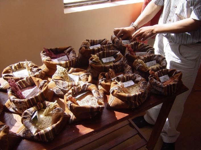
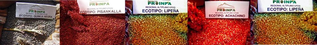
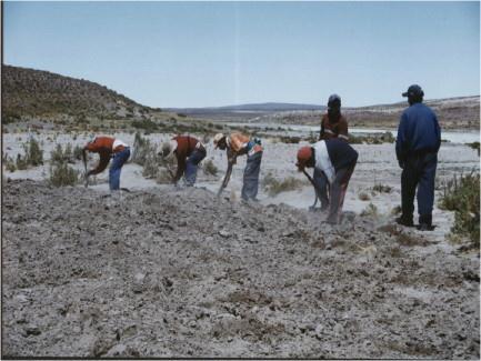
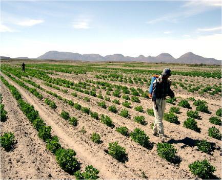
 Credits: Dorothea Lange; The Library of Congress,")
11 Migrant Mother series. Woman with children in a tent. Nipomo, California (1936) Credits: Dorothea Lange; The Library of Congress, Prints & Photographs Division
12
13 Is the past just a prologue of what's to come?

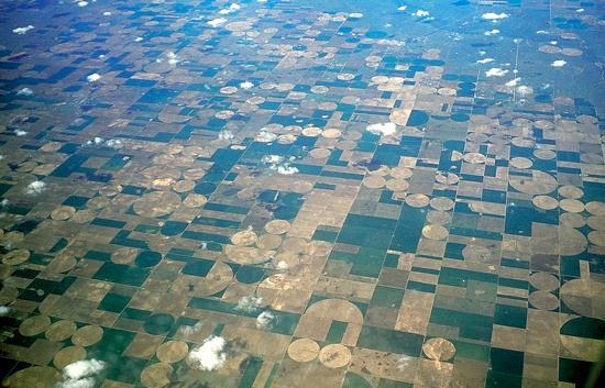
14 Ogallala Aquifer


15 Is the past just a prologue of what's to come? Massive dust storm, N. Oklahoma 19-Oct-2012

16 That will never happen again. Oklahoma Secretary of Agriculture Jim Reese
, MEXICO La Amapola,")

, Central ARGENTINA")
17 Tri-City Border: (Las Cruces, El Paso, Juarez) ARIDnet - Americas Huasteca Sur, Sierra Madre Oriental (Huichihuayan), MEXICO La Amapola, MEXICO Nochixtlán (Mixteca Alta), MEXICO La Sepultura (Chiapas) MEXICO El Alto Patía COLOMBIA Quesungual (Santa Rosa, Guarita, Candelaria,Lempira) HONDURAS) Salar de Uyuni, BOLIVIA Región de Coquimbo, CHILE The San Luis (Villa Mercedes), Central ARGENTINA Research Coordination Network

18 Salar de Uyuni in southern Bolivia

19 Altiplano (Andes High Plains)

20


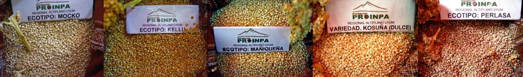
21 Farm communities in the Salar de Uni region Quinoa (Chenopodium quinoa Willd.) of Bolivia (Altiplano) Native Andes of Bolivia, Chile, Peru Quinoa "mother grain" in the Inca language Inca rice eaten continuously for 5,000 years as staple part of diet Remains important food crop for descendants
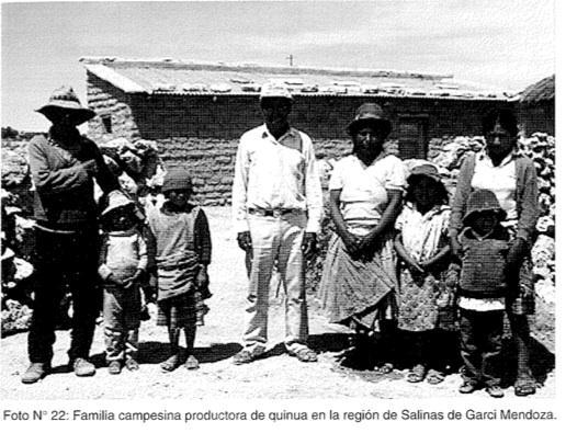
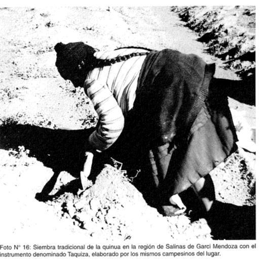
22


23


24 Salar de Uni region of Bolivia (Altiplano)


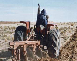
25 Organic stores in USA & Europe DEMAND Soil Fertility Wind, water erosion NGOs, USAID, etc Quinoa Introduction of tractors Land area of cultivation $ Family, community cooperation $$ Profits Health & Cultural traditions

26 Shakespeare s Tempest, Act 2, Scene I Full quote: Whereof what's past is prologue, what to come, In yours and my discharge. It is not only that events of the past have lead to what we see happening today but also that it is up to us what the future will bring


27 A N T O N I O Ousting his brother made him Duke Milan Are more foul deeds planned by this ruthless man? Whereof what's past is prologue
28
 Credits: Dorothea Lange; The Library of Congress,")
29 Abandoned farm with windmill and farm equipment. Dalhart, Texas (June 1938) Credits: Dorothea Lange; The Library of Congress, Prints & Photographs Division
Latin America. Chapter 9 Physical Geography
 Latin America Chapter 9 Physical Geography Latin American Regions Middle America includes Mexico and the Central American countries The Caribbean Islands South America Mexico Landforms Sierra Madre Oriental
Latin America. Physical Geography
 Latin America Physical Geography Regions Latin America can be divided into separate regions based on physical geography or cultural geography. Regions If we look at physical geography Latin America has
The Lesser Antilles. Dominican Republic), and Puerto Rico
, and Puerto Rico") The Caribbean Islands are archipelagoes or groups of islands. The major archipelagoes are: The Greater Antilles - Cuba, Jamaica, Hispaniola (Composed of Haiti and the Dominican Republic), and Puerto Rico
The Caribbean Islands are archipelagoes or groups of islands. The major archipelagoes are: The Greater Antilles - Cuba, Jamaica, Hispaniola (Composed of Haiti and the Dominican Republic), and Puerto Rico
Friday, November 10, 2017
 Friday, November 10, 2017 Andes and Midlatitude Countries Objective: Summarize the main physical features and regions of the Southern Cone. Identify and locate the urban centers and understand the pattern
This Great Nation Will Endure : Photographs of the Great Depression Thumbnails: FSA Photographs
 Franklin D. Roosevelt Presidential Library and Museum This Great Nation Will Endure : Photographs of the Great Depression Thumbnails: FSA Photographs, September 1939. Franklin D. Roosevelt Presidential
Latin America. Introduction
 Latin America Introduction What are the 5 Themes of Geography? Draw lines to connect the theme to the definition: Location How humans and the environment impact each other Physical and human characteristics
Latin America s Physical Geography. EQ: What are characteristics of Latin America s physical features?
 Latin America s Physical Geography EQ: What are characteristics of Latin America s physical features? Your Task: We are going to participate in a Museum Walk! You will travel around the room with a partner
Mrs. Reifsnyder World Geography. Unit 8: Latin America Study Guide SOLs Addressed: WG. 1c, 2b, 3c, 4, 10b/c
 Mrs. Reifsnyder World Geography Unit 8: Latin America Study Guide SOLs Addressed: WG. 1c, 2b, 3c, 4, 10b/c Essential Questions: - In what ways do physical, economic, and cultural characteristics influence
Objective. Students will familiarize themselves with the physical features and climates of Latin America.
 Journal Write KWL What do you KNOW about Latin America? What do you WANT TO KNOW about Latin America? What did you LEARN today that you didn t know before? Latin America Objective Students will familiarize
 Title of LOC item Farmer and Sons Dust Bowl in Cimarron County, Oklahoma Permanent URL http://memory.loc.gov/learn/collections/vdb/history.html Migrant agricultural worker's family. Seven hungry children.
US History, April 15
 US History, April 15 Entry Task: Take out your notes from yesterday (next slide). Announcements: Oops! ½ of the notes are missing a word. Including FACTS Website has the 1920s presentation, adding today
STUDY GUIDE. The Land. Physical Features of Latin America. Chapter 8, Section 1. Terms to Know DRAWING FROM EXPERIENCE ORGANIZING YOUR THOUGHTS
 For use with textbook pages 193 198. The Land Terms to Know cordillera A mountain range that runs parallel to another mountain range (page 194) altiplano A high plain (page 194) escarpment A steep cliff
Faces. Clothing. Living conditions. Environment - The weather, the landscape? Label your paper like this. - Expressions on peoples faces?
 Bell Ringer: Label your paper like this. Faces - Expressions on peoples faces? Clothing -What type of clothing do they have on? Living conditions - What are the conditions of the houses? Environment -
A funny sounding lake. South American Landforms, Climate, and Vegetation
 A funny sounding lake South American Landforms, Climate, and Vegetation 3 4 Essential Question: How have physical features and climate affected the population distribution of Latin America? 5 I. Landforms
CHAPTER 12. South America. Section 1: Natural Environments Section 2: History and Culture Section 3: South America Today. HOLT World Geography
 CHAPTER 12 South America Section 1: Natural Environments Section 2: History and Culture Section 3: South America 1 Section 1 Natural Environments Objectives: What are the major landforms and rivers of
 http://www.loc.gov/exhibits/treasures/images/at0181_10.jpg http://www.loc.gov/exhibits/treasures/images/s61a.8.jpg http://www.loc.gov/exhibits/land/4124m.html http://lcweb2.loc.gov/cgibin/query/i?ammem/fsaall:@field(number+@band(fsa+8a30882)):displaytype=1:m8
4th Grade Third 9 Weeks Test
 4th Grade Third 9 Weeks Test Multiple Choice Identify the choice that best completes the statement or answers the question. 1 A waterway for ships that is dug across land is called a. A port C river B
The Land Photo Source: The Atlas of Canada, The Red River, Manatoba, Canada land/physio_red_ri
 The Land The United States and Canada An Overview of the Region The United States and Canada are the two largest countries in North America. The Rio Grande is part of the southwest border of the United
Requests by Intake and Case Status Period. Intake 1 Case Review 6
 Number of Form I-821D,Consideration of Deferred Action for Childhood Arrivals, by Fiscal Year, Quarter, Intake and Case Status Fiscal Year 2012-2018 (March 31, 2018) Requests by Intake and Case Status
OKLAHOMA HISTORY OKLAHOMA S GEOGRAPHY
 OKLAHOMA HISTORY OKLAHOMA S GEOGRAPHY BOARD QUESTIONS 1) HOW BIG IS OKLAHOMA? 2) HOW MANY COUNTIES ARE IN OKLAHOMA? 3) HOW FAR IS IT FROM OKC TO LAS ANGLES, CALIFORNIA? 4) HOW MANY STATE BORDER OKLAHOMA?
Curriculum Pacing Guide Grade/Course 5 Th Grade Geography Grading Period 1 st Nine Weeks
 2013-2014 Curriculum Pacing Guide Grade/Course 5 Th Grade Grading Period 1 st Nine Weeks Time Frame Unit/ photographs, pictures, and tables to Locate and identify: Continents and Oceans -North America
Region 1 Piney Woods
 Region 1 Piney Woods Piney Woods 1. This ecoregion is found in East Texas. 2. Climate: average annual rainfall of 36 to 50 inches is fairly uniformly distributed throughout the year, and humidity and temperatures
3rd GRADE MINIMUM CONTENTS UDI 1: LANDSCAPES (5)
") 3rd GRADE MINIMUM CONTENTS UDI 1: LANDSCAPES (5) DIFFERENT LANDSCAPES A landscape is all the things that we see in a place. There are different types of landscapes. Mountain landscapes have mountains and
3rd GRADE MINIMUM CONTENTS UDI 1: LANDSCAPES (5) DIFFERENT LANDSCAPES A landscape is all the things that we see in a place. There are different types of landscapes. Mountain landscapes have mountains and
What Is An Ecoregion?
 Ecoregions of Texas What Is An Ecoregion? Ecoregion a major ecosystem with distinctive geography, characteristic plants and animals, and ecosystems that receives uniform solar radiation and moisture Sometimes
Pre-Release Material for examination on 17 June To be opened on receipt. A new copy of this Folder will be given out in the exmination.
 GCE A level 1204/01-B GEOGRAPHY - G4 SUSTAINABILITY Pre-Release Material for examination on 17 June 2011. To be opened on receipt. A new copy of this Folder will be given out in the exmination. RESOURCE
Latin America 11/4/2013. Latin America Today. 580 million people 9% of the world s population Diverse backgrounds:
 Latin America Chapter 10 Human Geography Latin America Today 580 million people 9% of the world s population Diverse backgrounds: Native Americans Europeans Africans Asians 1 Population 393 million live
WORLD GEOGRAPHY. Hector Rodriguez
 Mr. Chavira 9th Period WORLD GEOGRAPHY Hector Rodriguez P a g e 1 Table of Contents Latin America Page 2 o Maps Economic Map Page 3 Political Map Page 4 Population Map Page 5 Physical Page 6 o Notes Physical
Fieldwork Dates AmericasBarometer
 Fieldwork Dates AmericasBarometer 2004-2014 This document contains information regarding fieldwork s for the AmericasBarometer project, 2004-2014. Some information may be incomplete and we will up the
LOCATION, CLIMATE, AND NATURAL RESOURCES OF MEXICO
 SS6G3 The student will explain the impact of location, climate, distribution of natural resources, and population distribution on Latin America and the Caribbean. a. Compare how the location, climate,
Name Date The Great Depression & The New Deal
 Name Date The Great Depression & The New Deal The Great Depression & the New Deal The United States was booming and many people invested money in the stock market. In October, stocks began to lose their
Mrs. Davis s Adventures
 Mrs. Davis s Adventures Latin America Countries & Political Map NAME: DATE: PERIOD: DIRECTIONS: Use your mapping skills and textbook pages: 127, 97, and 3 to complete Mrs. Davis s Story. Transfer the countries
Essential Questions. 1. How have historical figures and events affected South America today?
 South America Essential Questions 1. How have historical figures and events affected South America today? 2. How has location affected the development of countries in South America? 3. How has the role
CHAPTER Latin America. Regional Atlas Study Guide. 2 Chapter A. As You Read. B. Reviewing Vocabulary
 CHAPTER 28 9 Many Th ew inventions new Regional Atlas Study Guide Latin America Directions: As you work through the Regional Atlas, complete the chart below by writing two details about each Latin American
1st Period Mr. Chavira WORLD GEOGRAPHY. Hector Rodriguez
 1st Period Mr. Chavira WORLD GEOGRAPHY Hector Rodriguez P a g e 1 Table of Contents Latin America Page 2 o Maps Economic Map Page 3 Political Map Page 4 Population Map Page 5 Physical Page 6 o Notes Physical
Geographic Qualities of South America
 Geographic Qualities of South America 1. South America is the fourth largest continent in area. It is located in the Western Hemisphere, lying southwest of North America. Most of South America lies in
THE USA. The capital of USA is Washington D.C., in the District of Columbia.
 THE USA The United States of America is the richest and one of the biggest countries in the world. It has a population of about 295 million people. It is divided into 50 states; two of them, Alaska and
*Latin America spans 7,000 miles, from Mexico to Tierra Del Fuego. *3 Regions: Central America, South America, and the Caribbean.
 Physical Geography Latin America spans 7,000 miles, from Mexico to Tierra Del Fuego *3 Regions: Central America, South America, and the Caribbean. *Intro clip: http://www.youtube.com/watch?v=cffp6rza3
Utah Nevada California Arizona New Mexico Baja California Texas Sonora Chihuahua Coahuila de Zaragoza Sinaloa Durango Nuevo León Zacatecas San Luis
 Nevada Utah California Arizona New Mexico Baja California Sonora Texas Chihuahua Coahuila de Zaragoza Sinaloa US States Mexico States International Boundary Durango Nayarit Zacatecas Jalisco Nuevo León
Regional Atlas: Introduction to Latin America
 Chapter 9, Section World Geography Chapter 9 Regional Atlas: Introduction to Latin America Copyright 2003 by Pearson Education, Inc., publishing as Prentice Hall, Upper Saddle River, NJ. All rights reserved.
Andean Mountain Initiative. World Mountain Forum 2018 Bishkek, October 23th, 2018
 Andean Mountain Initiative World Mountain Forum 2018 Bishkek, October 23th, 2018 The Andes range mountains The Andes are approximately 7,000 km long and are the world s longest terrestrial mountain range,
QUINOA IN PERU, May 2014
 QUINOA IN PERU, May 2014 Next to the tremendous growth of the Bolivian quinoa sector - which has brought benefits for the local economy as well as a lot of criticism from international media and scientists
The Earliest Americans
 The Earliest Americans A Land Bridge Section The Earliest Americans The cultures of the first Americans, including social organization, develop in ways similar to other early cultures. The American Continents
GEOGRAPHY AND HISTORY
 GEOGRAPHY AND HISTORY YEAR 1, PART 1 www.vicensvives.es Contents 01 Our planet Earth 02 The representation of the Earth: maps 03 The Earth s relief 04 Rivers and seas 05 Weather and climate 06 Climates
Summary Article: Mexico from Philip's Encyclopedia
 Topic Page: Mexico Summary Article: Mexico from Philip's Encyclopedia The United Mexican States is the world's largest Spanish-speaking country. It is largely mountainous. The Sierra Madre Occidental begins
Coast Country Memories of Camp Wallace 2003 Alecya Gallaway
 Coast Country Memories of Camp Wallace 2003 Alecya Gallaway National Archives On December 29, 1944, The Square knot a weekly newspaper for Camp Wallace reviewed eight months of Navy Wallace and in closing
South America. pg. 520 (5 th) pg. 523 (6 th )
 pg. 523 (6 th )") South America pg. 520 (5 th) pg. 523 (6 th ) Venezuela Rich in Oil Lake Maracaibo Called Little Venice pg. 572 (5 th) pg. 574 (6 th ) Caracas 8 miles Inland 3000 pg. 572 (5 th) pg. 574 (6 th ) Caracas
South America pg. 520 (5 th) pg. 523 (6 th ) Venezuela Rich in Oil Lake Maracaibo Called Little Venice pg. 572 (5 th) pg. 574 (6 th ) Caracas 8 miles Inland 3000 pg. 572 (5 th) pg. 574 (6 th ) Caracas
Month June 2011 South America (except Colombia for HA) Date of submission 01/07/11 MONTHLY REPORT
 Date of submission 01/07/11 MONTHLY REPORT") ANNEX IV-3 EUROPEAN COMMISSION HUMANITARIAN AID OFFICE (ECHO) Monthly report number 2011/6 Month June 2011 Country South America (except Colombia for HA) Date of submission 01/07/11 Author ECHO Quito MONTHLY
ANNEX IV-3 EUROPEAN COMMISSION HUMANITARIAN AID OFFICE (ECHO) Monthly report number 2011/6 Month June 2011 Country South America (except Colombia for HA) Date of submission 01/07/11 Author ECHO Quito MONTHLY
Geography: Unit 2. Map. Rivers. Major Physical Features. Slide 1. Slide 2. Slide 3. Slide 4. North America United States and Canada.
 Mississippi River Slide 1 Slide 2 Slide 3 Slide 4 Geography: Unit 2 North America United States Map Major Physical Features Mountain Ranges Brooks Range Mackenzie Mountains Coast Mountains Cascades Sierra
Why is the US industry and agriculture prosperous? The US industry and agriculture is so prosperous because it has many different natural resources.
 Ch. 1-7 Study Guide Why is the US industry and agriculture prosperous? The US industry and agriculture is so prosperous because it has many different natural resources. What likely drew immigrants to the
Sugar Cane production in both Haiti and the DR are down. New markets could restore production to historic levels.
 Sugar Cane production in both Haiti and the DR are down. New markets could restore production to historic levels. Sugar Cane Production in Haiti and the DR Dominican Republic 25 Haiti 2 15 1 Hectares Harvested
Warm Up Use complete sentences
 Warm Up Use complete sentences What do you think are 3 differences between the Northern US and the Southern US that caused the Civil War? (asking what you think so there are no wrong answers except silly
LOCATION, LOCATION, LOCATION! Mexico, Venezuela, Cuba, and Brazil
 LOCATION, LOCATION, LOCATION! Mexico, Venezuela, Cuba, and Brazil GPS and E.Q. GPS: SS6G3 The student will explain the impact of location, climate, distribution of natural resources, and population distribution
Intro to U.S.A and Canada
 Intro to U.S.A and Canada Regions of North America Warm Up: List the states you have visited and tell me which one you like the best and why? What is North America? Continent / Landmass in the North &
World History: Patterns of Interaction
 The Americans: A Separate World, 40,000 B.C. A.D. 700 Although early American civilizations remain mysterious, we know that the earliest Americans most likely migrated from Asia and that complex cultures
April 02, Inca. The Inca controlled a vast empire covering parts of modern day Peru, Ecudor, Bolivia, Chile, and Argentina.
 Inca The Inca controlled a vast empire covering parts of modern day Peru, Ecudor, Bolivia, Chile, and Argentina. Find the Incan Empire on your map and color it in. April 02, 2014 Cuzco was the capital
Many ecotourists visit the various natural habitats in Central America. Why do you think ecotourism has become so popular?
 Chapter 9 Middle America and Spanish Speaking South America pg. 252 287 9 1 Central America pg. 255 259 Connecting to Your World What is one country in Central America that promotes ecotourism? Many ecotourists
ONDCP August Cocaine. Smuggling
 ONDCP-01-07 August 2007 Cocaine Smuggling in 2006 Produced by the Office of National Drug Control Policy Cocaine Smuggling in 2006 The counterdrug community estimates that between 530 and 710 metric tons
Weekly Disaster Stats Update
 Weekly Disaster Stats Update The Weekly Disaster Stats Update is published every week on Tuesday. The product is meant to provide a snapshot of major disaster statistics throughout the calendar year to-date,
Latin America and The Caribbean. A Closer Look.
 Latin America and The Caribbean A Closer Look. Mexico Capital: Mexico City The Location of Mexico Mexico is the second-largest country by size and population in Latin America.but the Largest Spanish -
Lecture #1: Introduction
 Anthropology G4210 The Rise of Andean Civilization T. D'Altroy September 8, 1999 Lecture #1: Introduction 1. purposes of the course a. examination of the nature and development of societies in the Andes
Regional Director Latin America and Caribbean
 U.S. GRAINS COUNCIL Around the world; Around the clock Kurt Shultz Regional Director Latin America and Caribbean Leveraged Funding Non-Cash $7.8 Million Member Cash $5.2 Million FAS Funds $14.8 Million
Latin America. Physical Geography
 + Latin America Physical Geography + I. Landforms A. Caribbean & Central America 1. Mexico is dominated by two mountain chains, collectively called the Sierra Madre. A high plateau is situated in between.
Aracely Arrives in the USA
 Aracely Arrives in the USA I met Aracely Jumpa ten years ago. Our group of eight riders were on a bike tour in Peru going over the Andes Mountains and into a remote area of the jungle. Aracely lived with
Alumni. Section 8: Alumni
 Alumni Section 8: Alumni This section includes a table and three maps showing the distribution of all living alumni in California counties, in each state, and across the world. All data was provided by
Building Preparedness Capacity for Community Emergency Response and Disaster Mitigation. International Disaster and Risk Conference IDRC 2008
 Building Preparedness Capacity for Community Emergency Response and Disaster Mitigation International Disaster and Risk Conference IDRC 2008 Disaster Incidents in Latin America Over the Last 2-½ Years
Arthur Rothstein s. American Portraits. Pictures from the road Farm Security Administration
 Arthur Rothstein s American Portraits Pictures from the road 1936-1943 Farm Security Administration Edited and photobook design by C. Thomas Anderson Edited and photobook design by C. Thomas Anderson thegreatdepressionphotos.com
11/16/2015 PRESENTS COUNTRY SPOTLIGHT: Peru WHERE IN THE WORLD. Capital: Lima
 PRESENTS COUNTRY SPOTLIGHT: Peru WHERE IN THE WORLD Capital: Lima 1 GEOGRAPHY Located in South America Shares borders with Ecuador, Colombia, Brazil, Bolivia and Chile It s the third largest country in
Brain Wrinkles. Location, Climate, & Natural Resources of. Where People Live & How They Trade
 Location, Climate, & Natural Resources of Where People Live & How They Trade It s south of the US, east of the Pacific Ocean, and west of the Gulf of Mexico & Caribbean Sea. It s great that it s located
WESTERN PLANT BOARD. Attire In April, Las Cruces temperatures can reach a high of 85 in the day and a low of 50 at nig accordingly.
 WESTERN PLANT BOARD WESTERN PLANT BOARD OFFICERS Montana Utah Robert Gronowski, President Wyoming Arizona Clinton Campbell, Vice President Colorado Nevada, Secretary Idaho Oregon Doug Warner, Treasurer
Inter-American Defense College
 http://www.jid.org/iadc.php Inter-American Defense College Inter-American Defense College Building Confidence & Security Since 1962 A Confidence & Security Building Measure Inter-American Defense College
TABLE 1 VISITOR ARRIVALS. Total Visitor Arrivals +/ Month / / /18
 TABLE 1 VISITOR ARRIVALS Stopover Arrivals +/ Cruise Passengers +/ Total Visitor Arrivals +/ Month 2018 2019 2019/18 2018 2019 2019/18 2018 2019 2019/18 January 194,609 216,509 11.3% 249,635 249,239 0.2%
South America. Land of Color and Contrast
 South America Land of Color and Contrast Home to: *The world s largest river system *The longest mountain chain, and second tallest mountains *Earth s driest desert *One of the world s great grassland
UNIT 5 AFRICA PHYSICAL GEOGRAPHY SG 1 - PART II
 UNIT 5 AFRICA PHYSICAL GEOGRAPHY SG 1 - PART II III. CLIMATE & VEGETATION A. The four main climate zones are tropical wet, tropical wet/dry (split into monsoon & savanna), semiarid, and arid. Other climate
STANDARDS: Brain Wrinkles
 STANDARDS: SS6G3 The student will explain the impact of location, climate, distribution of natural resources, and population distribution on Latin America and the Caribbean. a. Compare how the location,
4/28/17. Clicker Question. Clicker Question. #37 Floods IV (Case Histories-Mississippi River Flood, 1993; Red River of North Flood, 1997)
") GEOL 118 Final Exam Format similar to exams 1 and 2 Covers Lectures #27 40 (Global Climate Change I - Meteorite Impacts III) Web Exercise #6 - Due by 1 pm, Monday (5/1) 8:00 AM, Thursday, May 11 th Location
GEOL 118 Final Exam Format similar to exams 1 and 2 Covers Lectures #27 40 (Global Climate Change I - Meteorite Impacts III) Web Exercise #6 - Due by 1 pm, Monday (5/1) 8:00 AM, Thursday, May 11 th Location
AUCTION BIDDING You may bid online during the auctions at www. LIVE ONLINE PORTFOLIO OVERVIEW
 PORTFOLIO OVERVIEW STATE COUNTY/ PARISH ACRES CROPLAND (FSA) AUCTION DATE Illinois Mercer 4,869± 4,657± Illinois Fulton 3,769± 3,596± December 12 Texas Hartley 11,240± Texas Moore 920± 11,646± December
Just how big is Africa?
 The United States China India The United Kingdom Portugal Spain France Belgium Germany The Netherlands Switzerland Italy Eastern Europe Japan 11.7 million sq. miles Just how big is Africa? Chapter 18 Section
Exploring Mexico. Directions: Complete the paragraphs below. Write the correct word from the Word Bank to complete each sentence.
 Exploring Mexico Section 1 10 Directions: Complete the paragraphs below. Write the correct word from the Word Bank to complete each sentence. Word Bank United States Central Plateau irrigation isthmus
Chapter 10 Study Guide SOUTH AMERICA
 Chapter 10 Study Guide SOUTH AMERICA When Spain and Portugal competed for trading lands in the New World, who came up with the line of demarcation to settle the dispute? The Caribbean Countries: Who was
SAJAMA (6549M) BOLIVIA S HIGHEST
 BOLIVIA S HIGHEST") SAJAMA (6549M) Classic Volcano climb BOLIVIA S HIGHEST West of La Paz near the border with Chile, there is a desert plain out of which rises the snow-capped cone volcano Sajama, found in Parque Nacional
SAJAMA (6549M) Classic Volcano climb BOLIVIA S HIGHEST West of La Paz near the border with Chile, there is a desert plain out of which rises the snow-capped cone volcano Sajama, found in Parque Nacional
Month February 2011 South America (except Colombia for HA) Date of submission 09/03/11 MONTHLY REPORT
 Date of submission 09/03/11 MONTHLY REPORT") EUROPEAN COMMISSION HUMANITARIAN AID OFFICE (ECHO) Monthly report number 2011/2 Month February 2011 Country South America (except Colombia for HA) Date of submission 09/03/11 Author ECHO Quito MONTHLY
EUROPEAN COMMISSION HUMANITARIAN AID OFFICE (ECHO) Monthly report number 2011/2 Month February 2011 Country South America (except Colombia for HA) Date of submission 09/03/11 Author ECHO Quito MONTHLY
Council Work Session Summary
 Meeting Date: September 12, 2016 Council Work Session Summary TITLE: THE HISTORY OF THE PIRO IN OUR REGION. PURPOSE(S) OF DISCUSSION: Inform/Update Direction/Guidance Legislative Development/Policy BACKGROUND
ALBERTA S GRASSLANDS IN CONTEXT
 ALBERTA S GRASSLANDS IN CONTEXT GLOBAL GRASSLANDS 1 Temperate grasslands, located north of the Tropic of Cancer and south of the Tropic of Capricorn, are one of the world s great terrestrial biomes 2.
Service and Research Opportunities through Peace Corps Response
 Service and Research Opportunities through Peace Corps Response Curt Holder Department of Geography and Environmental Studies University of Colorado Colorado Springs What is Peace Corps Response? Established
Income in the border region,
 Income in the border region, 1993-2010 NAFTA at Twenty: Effects on the North American Market Federal Reserve Bank of Dallas, Houston Branch June 5-6, 2014 Dr. James Gerber Professor of Economics San Diego
Brain Wrinkles. Africa: The impact of location, climate, & physical characteristics on where people live, the type of work they do, & how they travel
 Africa: The impact of location, climate, & physical characteristics on where people live, the type of work they do, & how they travel STANDARDS: SS7G3 The student will explain the impact of location, climate,
Art and Politics: Contemporary Arpilleras
 University of Nebraska - Lincoln DigitalCommons@University of Nebraska - Lincoln Textile Society of America Symposium Proceedings Textile Society of America 9-2012 Art and Politics: Contemporary Arpilleras
GUIDE PERU & BOLIVIA 28 DAYS SUMMER 2019
 GUIDE PERU & BOLIVIA SUMMER 2019 28 DAYS WHERE ARE YOU GOING? PERU & BOLIVIA These two neighbouring countries offer so many adventures and unmissable sights, it wouldn t be right to visit one and not the
GUIDE PERU & BOLIVIA 28 DAYS SUMMER 2019
 GUIDE PERU & BOLIVIA SUMMER 2019 28 DAYS These two neighbouring countries offer so many adventures and unmissable sights, it wouldn t be right to visit one and not the other! Peru and Bolivia offer a truly
Inventory of managed aquifer recharge schemes in Latin America
 Sponsored by Programa de Innovación y Capital Humano para la Competitividad Junior Research Group Global Change 4+1 Inventory of managed aquifer recharge schemes in Latin America José Pablo Bonilla Valverde,
The American Institute of Aeronautics and Astronautics
 The American Institute of Aeronautics and Astronautics Civilian Applications of UAVs A California Perspective, a Policy Symposium Michael Toscano President & CEO Association for Unmanned Vehicle Systems
Successful Experiences in Rio Grande/Rio Bravo Watershed Management
 Successful Experiences in Rio Grande/Rio Bravo Watershed Management 5 th th World Water Forum Istanbul, Turkey March 22-23, 23, 2009 Introduction A watershed with many voices a medley of cultures, customs,
World Geography Ch. 7.2 Climate Regions of Latin America
 World Geography Ch. 7.2 Climate Regions of Latin America BR: D10 When you think of Latin America, what types of climates do you think are down there? Write down which of the following you believe are there:
Of Mice and Men. By John Steinbeck
 Of Mice and Men By John Steinbeck John Steinbeck One of The Great American Writers of the 20 th Century A Look at the Author Born February 27 th in 1902 in Salinas, California, John was the third of four
Doing Business in Colombia. U.S. Department of Commerce International Trade Administration
 Doing Business in Colombia Colombia at a Glance 3 rd largest population in Latin America Strategic geographical location Among top 50 tourism destinations in 2009 Language: Spanish (official) Literacy
Dr. Christopher Brown New Mexico State University GEF Project Rio Meeting Ciudad Juárez, México 3-5 October 2006
 Political and Institutional Aspects of Rio Grande/ Río Bravo Basin Management Dr. Christopher Brown New Mexico State University GEF Project Rio Meeting Ciudad Juárez, México 3-5 October 2006 Institutional
LAST TIME (Happy 300 th Birthday Ben Franklin!)
") LAST TIME (Happy 300 th Birthday Ben Franklin!) Latin American Diversity: Introduction Physical Geography of Mexico, Caribbean, and Central America: 1. Mexican drylands 2. Mesoamerican Highlands 3. Coastal
LAST TIME (Happy 300 th Birthday Ben Franklin!) Latin American Diversity: Introduction Physical Geography of Mexico, Caribbean, and Central America: 1. Mexican drylands 2. Mesoamerican Highlands 3. Coastal
Mesoamerican Civilizations
 Mesoamerican Civilizations Human Migration Turn to page 237 and answer the two geography skillbuilder questions: What two continents does the Beringia land bridge connect? From where do scholars believe
Chile. World Geography South America
 Chile World Geography South America Chile Location Continent: South America Borders the Pacific Ocean Chile Overview Population: 17,789,267 (July 2017 est.) World Rank: 65 th Chile Overview Capital and
GUIDE PERU & BOLIVIA 28 DAYS
 GUIDE PERU & BOLIVIA 28 DAYS SUMMER 2019 WHERE ARE YOU GOING? PERU & BOLIVIA These two neighbouring countries offer so many adventures and unmissable sights, it wouldn t be right to visit one and not or!