Schedule 1 to the Demolition Permit Request Regarding Three Ancillary Buildings at the Lakeview Generating Station Site: Heritage Impact Statement
|
|
|
- Mitchell Manning
- 6 years ago
- Views:
Transcription
1
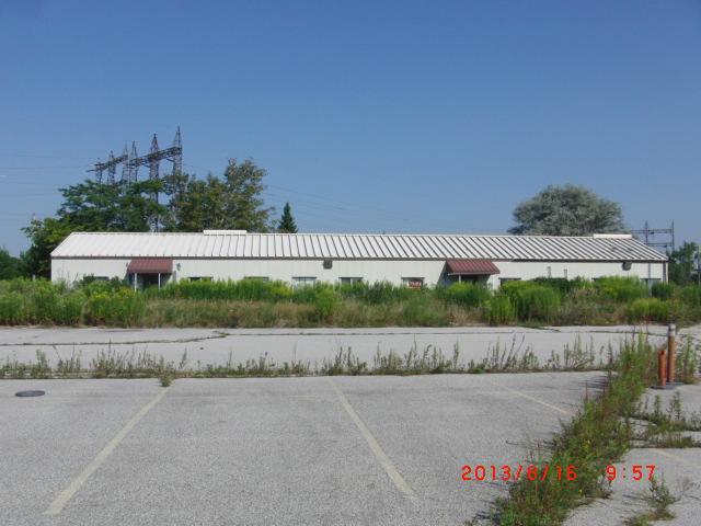
2 Schedule 1 to the Demolition Permit Request Regarding Three Ancillary Buildings at the Lakeview Generating Station Site: Heritage Impact Statement Introduction Ontario Power Generation Inc. (OPG) wishes to demolish three of the four remaining ancillary building at the site of the former Lakeview Generating Station (the Site). The City of Mississauga (the City) issued two permits authorizing the demolition of all buildings and structures on the Site on March 22nd, 2006 and April 26th, 2006 (see attached Appendix B). Pursuant to the City s approval, the demolition of the main structures of the Lakeview Generating Station commenced in The ancillary buildings subject to this application were included in the 2006 demolition permit approval, however, OPG retained those buildings to be used during site decommissioning. These buildings are temporary and portable in nature (see picture on page 21 of this document, below). These buildings serve no current purpose and thus, can now be demolished. Accordingly, in July 2013, OPG contracted Delsan Aim Environmental. Services (DAES) of Concord, Ontario, to demolish these three buildings at the Site. OPG will retain the existing guardhouse at the entrance to the site for security purposes. Background In January 2005, the City listed the Lakeview Generating Station in its Heritage Inventory for, among other things, that it formed a significant cultural landscape and was a recognized landmark on Mississauga s waterfront. However, in March, 2001, the provincial government had announced that Lakeview would be required to stop burning coal by April, This was confirmed in October, 2003, when the provincial government directed OPG to decommission Lakeview by Given the province s coal closure policy, there was no future purpose for the facility. Thus OPG contracted Murray Demolition LP (Murray) for the demolition of the facility. Murray made an application to the City for this purpose and as required by the City, the package included a Heritage Impact Statement for the Site (see Appendix C). Murray received the attached demolition permit from the City. Accordingly, on June 12, 2006, the Four Sisters were demolished. On June 28, 2007, the rest of the powerhouse buildings were demolished. Thus, the primary aspects of heritage and cultural value contemplated in the City s Heritage Inventory no longer exists. The following is a summary of the Heritage Impact Statement, prepared for your convenient reference. 2
3 Summary of Heritage Impact Statement for Lakeview Generating Station Site 3
4 Site History Property Title Search The Corporate Real Estate Division of Ontario Hydro conducted a property title search of the Lakeview Generating Station Site in the winter of The land assembly includes parts of Lots 7, 8 and 9, Concession 3 SDS, all in the former Township of Toronto, County of Peel, which is now the City of Mississauga, Regional Municipality of Peel. The title search revealed an extensive history of property transactions dating from as early as Ontario Hydro began acquiring most of the property rights at the subject site in 1959 with the last property obtained in In most instances property was granted from the Crown. The Corporation of the Township of Toronto acquired several parcels of land from Ontario Hydro beginning in 1960, including a significant parcel of land north of the switchyard and south of Lakeshore Road which was to be sold off for industrial development. Also, in a 1983 licence agreement, Ontario Hydro permitted the Credit Valley Conservation Authority to use part of its land at the western edge of the property for the purpose of the construction of the Lakeview Promenade Park including breakwater. The site is legally described as Part Lots 7, 8 and 9, Concession 3 SDS, and part of Water Lots, designated as Parts 1-49 on 43R-23371, City of Mississauga. The table shown on the following page lists the entities that were reported to be associated with ownership or occupation of the site during the specified time periods. 4
5 Table 1 Property Title Search Registered Owner(s) Ownership Period Part Lot 7 His Majesty The King July 1881 July 1914 The Hydro-Electric Power Commission July 1914 June 1958 The Hydro-Electric Power Commission of June 1958 Present Ontario (a.k.a. Ontario Hydro) Part Lot 8 The Corporation of the City of Toronto July 1892 February 1932 His Majesty The King February 1932 March 1958 The Corporation of the City of Toronto March 1958 July 1958 The Hydro-Electric Power Commission of July 1958 Present Ontario (a.k.a. Ontario Hydro) Part Lot 9 T.S. Kennedy January 1876 Unknown Anna C. Cawthra Unknown September 1912 His Majesty The King September 1912 February 1960 The Hydro-Electric Power Commission of February 1960 Present Ontario (a.k.a. Ontario Hydro) Water Lot HY28 The Crown Prior to May 1960 The Hydro-Electric Power Commission of May 1960 Present Ontario (a.k.a. Ontario Hydro) Water Lot in Front of Part Lot 9 The Crown Prior to January 1910 Anna C. Cawthra January 1910 September 1912 His Majesty The King September 1912 December 1958 The Corporation of the Township of December 1958 February 1965 Toronto The Hydro-Electric Power Commission of February 1965 Present Ontario (a.k.a. Ontario Hydro) Water Lot HY77 The Crown Prior to June 1967 The Hydro-Electric Power Commission of June 1967 Present Ontario (a.k.a. Ontario Hydro) Water Lot HY116 The Crown Prior to April 1970 The Hydro-Electric Power Commission of April 1970 Present Ontario (a.k.a. Ontario Hydro) 5
6 Long Branch Rifle Ranges and Aerodrome 1891 to 1958 At the end of the nineteenth century, there was a rifle range located on land neighbouring the property where the Lakeview Generating Station would eventually be constructed. The rifle range came into existence after the City of Toronto had deemed in a council meeting in 1881 that the rifle range located in the city limits at that time was unsafe. The Council subsequently made a request for the Federal government to locate a site outside the city that would be more suitable. About ten years later, a new rifle range was founded in 1891 when 100 acres (40 ha) of land in Toronto Township (Lakeview) was purchased by the Federal government. The land located south of Lake Shore Road was registered as Lot 5, Con. 3, SDS. The rifle range, which fell under the jurisdiction of the Ontario Militia Department, was named the Long Branch Rifle Ranges and steadily grew in popularity with membership increasing so that by 1908 more land was purchased to increase the range to 365 acres (147.7 ha). The land acquired was Lots 4, 6, 7, 8, 9, and part of 10. The present day Lakeview Generating Station is situated on some of the land that encompassed the Rifle Ranges. During the life of the Rifle Ranges, it was used by the Ontario Rifle Association for not only recreation but also the training of young men to prepare them for the armed forces. The Department of National Defence used the site during the Second World War ( ) for training purposes. Toronto Curtiss Airplane Factory, which was owned by Hammondsport, New York based Curtiss Airplane Factory opened Canada s first aerodrome and flying school at the Lakeview Rifle Ranges in May, The manager, John Alexander Douglas McCurdy (b in Baddeck, Nova Scotia), was Canada s first aviator. The school operated for two years before being closed down in December, In January, 1917, the Royal Flying Corps was created and the site was used as a cadet training school. Many of the pilots that graduated from this school went to England to serve with the Royal Naval Air Services during the First World War. With the growth of the Royal Flying Corps, the Rifle Ranges airfield became too small and the operation was moved to Camp Borden in Penetanguishene. There is an Ontario Archaeological and Historical Sites Board plaque as shown in the Photo 1 on Page 5, which is located at the corner of Lakeshore Road and Hydro Road and commemorates the site of the former Aerodrome. The plaque was dedicated on September 21, 1969, and unveiled by the former Toronto Mayor Bert S. Wemp who had been a graduate of the school. 6
 Rifle Ranges property was transferred from the Department of National Defence to the Toronto Township.")
7 Photo 1 Historical Plaque During the 1950s, the Toronto Township was growing rapidly and the Council wanted the land for industrial development and public purposes such as a sewage and water plants and parks. In the summer of 1954, the 350 acres (141.7 ha) Rifle Ranges property was transferred from the Department of National Defence to the Toronto Township. The Ontario Rifle Association moved its school to the Ottawa Connaught Ranges The Lakeview Generating Station 1958 to 2005 Lakeview Generating Station was one of five coal-fuelled generating stations operated by Ontario Power Generation. The station is situated on the north shore of Lake Ontario, in the City of Mississauga. The construction for an eight unit coal burning generating plant by Ontario Hydro began on June 1, 1958, on 85 acres (34 ha) on the shore of Lake Ontario in Lakeview, which was purchased from the City of Toronto. The units were brought into service over the seven-year period between 1962 and Photo 2 shows an aerial photo of the site circa 1958 prior to the commencement of construction. The first unit produced power in November, 1962 and is shown in Photo 3. The road leading into the plant is called Hydro Road, where the property was used for the Rifle Ranges and the first Aerodrome. Eventually the plant would occupy 144 acres. When the first two units began operating, they were the only 300 megawatt generators in Canada. When the eight units were completed in 1968, the station was reputed to be the largest fossil station in the world, capable of producing 2400 megawatts of power and employed more than 600 staff. The eight-300 mega-watt turbo generators were built by Canadian General Electric in Peterborough. 7

8 The official opening of the Lakeview Generating Station took place on June 20, 1962, with Prime Minister John Robarts and Ontario Hydro chairman W. Ross Strike pushing the button to start up the first 300,000 kilowatt unit to produce electricity. The station was the first 3, 000,000 kilowatt thermal-electric plant in Canada. Robarts commented that, The Lakeview Generation Station is a tangible expression of confidence in the contribution electricity would make to the continued growth and well being of the citizens of Ontario. A plaque was unveiled that paid tribute to the spirit of cooperation that prevailed during construction. Upon completion in 1968 at a cost of $274 million, it became the world s largest fossil generating station capable of producing 2.4 billion watts of power. Lakeview ran at its highest capacity during from the late 1960s and early 1980s, supplying 2,400 megawatts of the province s electrical needs. The most dominant feature of the station is its stacks, affectionately known as the "The Four Sisters", which are about 150 metres (490 feet) tall. The stacks as shown in the following photograph are visible for miles and are used by boaters and commercial pilots as a navigational landmark. Photo 2 Official Opening June 20, 1962 (Courtesy: Larry Onisto, OPG) 8

9 Photo 3 The Four Sisters (Courtesy: Larry Onisto, OPG) When Lakeview's eight generating units were first built, they played an important role in providing customers with a reliable supply of electricity 24 hours a day, seven days a week. Recently, the station had four operating units, which supplied electricity primarily during winter and summer peaking hours for Ontario customers, operating about 20 per cent of the time. In the early 1990s, four units of the station were rehabilitated, which upgraded major equipment and extended the service life of the units. These improvements helped Lakeview Generating Station produce electricity for customers more efficiently and reliably and with less impact on the environment. In 1960, a docking causeway was constructed. Built of steel cells 48 feet (14.8 m) in diameter weighed down with rock and concrete, it extended 2,000 feet out into Lake Ontario. Here self-unloading ships would discharge coal onto conveyor belt that would carry it, at a rate of 2,000 tons an hour, to the storage area that could hold 2,500,000 tons of coal. 9

10 Chronology of Major Milestones June 1, 1958 Construction begins on 52 hectares of land purchased from the City of Toronto July 24, Ontario Hydro announces the addition of a third and fourth 300,000 kilowatt generating unit to Lakeview by 1964 Unit 1 produces first electricity on October 30 th Units 2 4 in service Photo 4 Aerial Photo of Units 1 4, Circa 1964 (Courtesy: Larry Onisto, OPG) 10

11 Units 5 8 in service s On the waterfront of Lake Ontario, The Four Sisters Lakeview s four 150 metre concrete stacks became a familiar navigational beacon for boats, ships and airplanes. Lakeview ran at its highest capacity as a base load plant from the late 1960s to the early 1980s and met about 17 per cent of the province s energy needs. During this time, Lakeview played an important role in providing an around-the-clock, reliable supply of electricity to Ontario s energy customers. Photo 5 Aerial Photo, 1972 (Courtesy: Larry Onisto, OPG) 11

12 1980s In 1980, as fuel alternatives such as nuclear units came on line at Pickering and Bruce, Lakeview s role in the electricity marketplace changed. It transitioned to a four-unit peaking plant, due to its higher costs operating only when electricity demands were highest, or other generating units were not available. In 1986, the station began to use lower-sulphur coal to reduce emissions of sulphur dioxide and nitrogen oxides $1.1 billion was invested in rehabilitation to increase efficiency and reliability, and the addition of acid gas control equipment to all eight units. By 1992, only four units had been overhauled when repairs were halted due to the changing future outlook and to a decline in the consumer use of energy, due to economic recession. Photo 6 Aerial Photo, 1992 (Courtesy: Larry Onisto, OPG) 12
13 In January, 1993, reduced load forecasts resulted in the decommissioning of Units 3, 4, 7 and 8. In 1994, the plant returned to service as a four-unit peak-demand generating station, but with a much improved environmental performance. Lakeview continued to provide customer with a safe, reliable source of power when demand was highest, and became a key asset in times of uncertainty in the electricity marketplace. The station s location in the Greater Toronto Area made its output invaluable to some of Ontario s largest municipal utilities and industries especially when nuclear and other generation was not available In December, 1998, Ontario Hydro announced a joint venture to pursue the development of a 550 MW natural gas-fired combined cycle power plant at Lakeview. The venture was dissolved in May, In March, 2001, the provincial government announced that Lakeview would be required to stop burning coal by April, In October, 2003, the provincial government confirmed that Lakeview would close on April, 2005, with the remainder of OPG s fossil-fuelled plants removed from service by the end of In June12, 2006, The Four Sisters were successfully imploded by Murray Demolition LP, in order of east to west, falling to the east with a stack toppling every 4 seconds. Over a thousand spectators came to a nearly park to observe the demolition. Helicopters filled the sky, each taking footage of the event. June 28, 2007, The rest of the powerhouse building was demolished at 11:04am EST. 13
 of land in the District of Lakeview in the City of Mississauga, Ontario as shown on the following Site Location Map. The City of Mississauga Lakeview District Land Use Map (Amendment No.")
14 Description of the Site and the Surrounding Area Location and Land Use The Lakeview Generating Station is located on the north shore of Lake Ontario on 128 acres (51.2 hectares) of land in the District of Lakeview in the City of Mississauga, Ontario as shown on the following Site Location Map. The City of Mississauga Lakeview District Land Use Map (Amendment No. 11 to the City Plan) dated March 2002 shows the land use designation of the site as "Utility Generating Station". The City of Mississauga, Planning and Building Department, Map 01 (Schedule B to Bylaw 5500) dated April 20, 2005, shows the site zoning as "M1 Industrial". 14

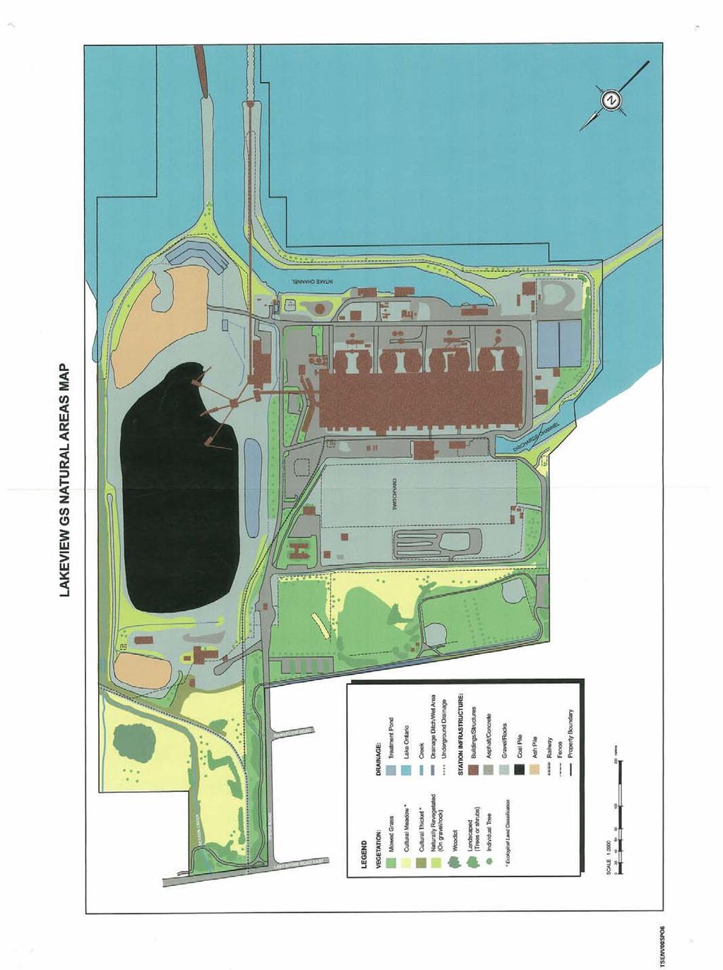
15 The Surrounding Area The area immediately surrounding the generating station consists of different land uses from "Utility" to the east, "Business Employment" to the north and "Open Space City Park" to the west. The Lakeview Water Pollution Control Plant is located on the neighbouring property immediately east of the plant along the shoreline of Lake Ontario. There is a greenbelt that runs southward between the two plants where a small creek called Serson Creek, flows to the lake. Bordering the west side of the property is the Lakefront Promenade Park and located a little further west is the Ministry of the Environment South Peel Lakeview Water Treatment Plant. The park and the treatment plant can be seen in the foreground of the following aerial photo with the generating station in the background. Photo 7 Aerial Photo Looking South-East (Courtesy: Larry Onisto, OPG) Site Description A large storage area dominates the eastern side of the property where coal and fly ash used to be stockpiled during the operation of the plant. The storage area, as shown on the Lakeview G.S. Natural Areas Map in black, had a capacity of 2.5 million tons (2.3 million Mg) of coal and along with the conveyor equipment and associated buildings, was known collectively as the Coal Yard. The storage area was also used to store fly ash at the northern and southern ends and is surrounded by gravel areas. The conveyor equipment and structures, that were used to transport the coal from the unloading dock to the coal pile and the plant, are located adjacent to the Main Service Road on the west side of the Coal Yard. Along the shoreline, south of the Coal Yard, there are areas of rock and gravel that have been naturally re-vegetated and to the north of the fence line, cultural meadow and thicket. 15
16 On the western half of the property, the station infrastructure is dominated by the main building that houses the boilers, coal bunkers and electrical generating equipment and rises to a height of 190' (58 m) with a footprint of 391,900 square feet (36,408 m 2 ). This massive structure called the Powerhouse is the most prominent man-made feature on the site with four, 490' (149 m) chimneys towering above the south side of the building. Ancillary buildings housing equipment to pump water are situated along the shoreline. As well, there are offices and a water treatment plant connected to the east side of the Powerhouse and storage buildings to the north. Around these building, the surrounding land is covered with asphalt, concrete and gravel as shown on the natural areas map. There is a large switchyard, which is covered with gravel, north of the Powerhouse where the generated electricity was transmitted through power lines. Outside the fence line north of the switchyard, the remainder of the property slopes upward onto meadow and a field of mowed grass where there are two baseball diamonds and soccer pitch. There are some trees dispersed in this area. Standing in this field are transmission towers that supported the power lines leaving the generating station. A series of transmission towers further conveyed the power lines northward connecting them to the power grid system through a utility right-of-way running parallel to Hydro Road and beyond. The southern extent of the property is bounded by Lake Ontario, which is a 7,550 square mile (19,300 km 2 ) body of fresh water. The lake connects to the St. Lawrence Seaway and the Atlantic Ocean allowing coal-carrying ships to transport coal to the plant and unload at the plant docking facility. The lake also played an essential role in the functioning of the generating station providing water for not only the boilers in order to produce steam but also cooling the condensers and controlling dust in the Coal Yard. The shoreline was modified to accommodate the water intake requirements of the plant and to allow ships to dock and unload coal. The following aerial photo of the site, looking north, shows the early stages of plant construction in 1958, which gives an idea of the original shoreline. 16
 breakwater had been constructed to create an Intake Channel and Forebay, as shown on the site plan that would provide shelter for the intake pumps supplying water for the")
17 Photo 8 Aerial Photo (Circa 1958) (Courtesy: Larry Onisto, OPG) By the time the plant opened in 1962, the shoreline had been transformed. A 1000 foot (305 m) breakwater had been constructed to create an Intake Channel and Forebay, as shown on the site plan that would provide shelter for the intake pumps supplying water for the generating station. The breakwater was formed using rocks and boulders some weighing up to 11 tons hauled to the site by truck. A docking causeway extended from the breakwater 1,970 feet (600 m) off shore. It was constructed using 48' (14.6 m) diameter steel cells that were filled with rock and concrete. On the west side of the site, the shoreline was further altered with the construction of a Discharge Channel, which was used for the return of water to Lake Ontario. The aerial photo on the following page, shows the readily identifiable man-made features of the Intake Channel, Forebay and Discharge Channel. In subsequent years, the eastern groin of the Intake Channel, as shown on Photo 5, was extended into the lake with the addition of the hauls of three steel barges that were set in place and filled with concrete. The shoreline along the entire extent of the property has been protected with gravel and rock, as shown on the natural areas map, with the breakwater and areas south of the Coal Yard having been naturally re-vegetated with some trees, grasses and shrubs. There are some treatment ponds on site as shown on the natural areas map one that used to be located west of Coal Yard, as well as the Coal Yard Run-Off Pond to the south and the Ash Settling Ponds, west of the Powerhouse. 17

18 Photo 9 Aerial Photo (Circa 1962) (Courtesy: Larry Onisto, OPG) The main entrance to the property is at the end of Hydro Road, which starts at Lakeshore Road (Hwy. 2) and runs southward. The site is secured with a chain-link fence that lines the perimeter of the property as delineated on the site plan. There are electronic gates at the main entrance where a guard house is located (Structure No. 5). Site security personnel, who are posted in this building, patrol the site and control entry into the plant. Inside the gate, an asphalt-paved roadway, called the Main Service Road, continues southward towards the lake providing access to parking areas adjacent to the Administration Building (Structure No. 78) as well as the Coal Yard Utility Building (Structure No. 79). On the east side of this roadway, there is a drainage ditch as shown on the natural areas map that drains southward toward the lake. On the other side of the ditch the property rises up slightly to the Coal Yard. There is a row of cultivated trees that line the same side of the road as well as trees that were planted in a mowed grass area east of the Administration Building. Roads branch off to the west on both sides of the Powerhouse allowing access to all sides of the plant as well as the storage area to the north and the pump houses to the south. A roadway runs along the shoreline around the Forebay eastward on top of the breakwater and onto the docking causeway. This roadway also continues westward along the shoreline and turns northward at the west extent of the property where it is identified as the West Access Roadway. Intersecting the Main Service Road, just inside the main gate, is the Switchyard Road that runs westward to provide access to the Switchyard Area as well as the Tour Centre (Structure No. 17) and some storage buildings. There is some additional landscaped areas with shrubs and trees and naturally re-vegetated areas along the Discharge Channel. Running southward, parallel to Hydro Road, a Canadian National Rail spur line enters the plant east of the main gate. The line, which is no longer operational, spits into two with one section running parallel to the Main Service Road where it ends; the other line continues towards the north-west corner of the Powerhouse and enters the building in an area referred to as the Loading Bay. 18
19 Documentation of Site and the Existing Structures Introduction The following section describes the Lakeview Generating Station Site in detail including the natural and man-made features and gives a complete listing and description of all the existing structures located on the property. Only those structures that are scheduled to be demolished are documented in this report. The report references the following drawings that were provided by Ontario Power Generation, Inc. (OPG) and are reproduced in Appendix I. Lakeview G.S. Site Plan Buildings & Miscellaneous Structures, General Arrangement Lakeview G.S. Natural Areas Map OPG has identified each of the structures on the site plan by number. This numbering system is used in this report in order to locate each of the structures on site. 19

 by 72' (22 m) structure that was used as office space during the rehabilitation of the plant in the early 1990s.")
20 Structure No. 1 Lakeview Rehabilitation Commissioning Office / Fitness Centre The Lakeview Rehabilitation Commissioning Office, later re-named the Fitness Centre, is not shown on the site plan that was provided with this report. It is, however, located south of the Tour Centre just east of the Switchyard. The building was constructed in 1989 and is a single storey, 50'(15.2 m) by 72' (22 m) structure that was used as office space during the rehabilitation of the plant in the early 1990s. The building floor, walls and roof are framed with timber and covered with plywood and supported on concrete piers. There are aluminium-framed windows around the building with the exterior walls being clad with steel siding. The interior walls are clad with vinyl covered drywall and the floors with vinyl tile and rug. The ceiling consists of acoustical lay-in panels and fluorescent lights supported on a suspended metal grid of tees. Photo 1 Structure No.1 Lakeview Rehabilitation Commissioning Office South Elevation Photo 2 Structure No. 4 Lakeview Rehabilitation Commissioning Office Interior 20
 by 10' (3 m) high structure constructed of masonry bearing walls of concrete block. The interior partition walls are also concrete block.")
21 Structure No. 9 & No. 10 HEPCO Building Structure No. 9, identified as the HEPCO Building, is a 34' 6" by 32' (10.5 m by 9.8 m) by 10' (3 m) high structure constructed of masonry bearing walls of concrete block. The interior partition walls are also concrete block. The roof is flat steel framed with a metal pan and built-up roof and the building is founded on reinforced concrete footings with the floor being a reinforced concrete slab on grade. The building functioned as offices for personnel operating the adjacent weigh scale, which is identified on the site plan as Structure No. 10. Photo 16 Structure No. 9 HEPCO Building South Elevation Structure No. 3 Lakeview Rehabilitation Project office / Tour Centre The Lakeview Rehabilitation Project Office, later re-named the Tour Centre, is shown on the site plan that was provided with this report. The building was constructed in 1989 and is a single storey, (32.9 m) by 86-9 (26.4 m) by 10 h (3m) structure that was used as office space during the rehabilitation of the plant in the early 1990s. The shape of the building is similar to the letter H. A walk-in vault is attached to a wall to the building. The building walls and roof are framed with timber and covered with plywood rest on a slab on grade.. There are aluminium-framed windows around the building with the exterior walls being clad with steel siding. The interior walls are clad with vinyl covered drywall and the floors with vinyl tile and rug. The ceiling consists of acoustical lay-in panels and fluorescent lights supported on a suspended metal grid of tees. 21
22 22
23 Appendix A Site Plan 23
24 The image cannot be displayed. Your computer may not have enough memory to open the image, or the image may have been corrupted. Restart your computer, and then open the file again. If the red x still appears, you may have to delete the image and then insert it again. 24
25 25
Table of Contents. Location... 1 Cultural Heritage Value... 3 Site History... 4 Physical Description... 6 Conclusion... 7 Sources...
 Executive Summary The Outdoor Firing Range, located west of the Small Arms Building at 1300 Lakeshore Road East, merits designation under the Ontario Heritage Act for its historical, architectural and
Appendix B. Cultural Heritage Properties
 Appendix B Cultural Heritage Properties Existing Conditions Report Page 1 1. CHL Industrial Port Lands Industrial District. Bounded by Lake Shore Boulevard on the north, Leslie Street on the east, Inner
communication tower means a tower or structure built to support equipment used to transmit communication signals;
 Ontario Ministry of Natural Resources Subject Communication Tower Sites on Crown Land Compiled by - Branch Lands & Waters Section Land Management Policy PL 4.10.02 Replaces Directive Title Communication
Appendix C. Cultural Heritage Properties
 Appendix C Cultural Heritage Properties Existing Conditions Report Page 1 Don River Mouth Naturalization and Port Lands Flood Protection Project Appendix C: Inventory of Cultural Heritage Properties in
Energy from Waste and Recycling Facility Trident Park, Cardiff. Planning History. January 2010 SLR Ref: B
 Energy from Waste and Recycling Facility Trident Park, Cardiff Planning History January 2010 Ref: 402-0036-0306B Viridor Ltd. i 402/0036/00306B CONTENTS 1.0 INTRODUCTION... 1 2.0 GENERAL HISTORY... 3
Almaguin Strategic Plan - South River/Sundridge Airport
 June June 29, 29, 2009 2009 Page 1 Precision Management 26 Canterbury Crescent North Bay, Ontario P1C 1K7 Attention: Ms. Linda Wilson, B.B.A. (Hon.), M.B.A Re: Almaguin Strategic Plan - South River/Sundridge
RAY YENKANA Willowbrook Cr, Dawson Creek BC Canada $2,847,000
 1716 Willowbrook Cr, Dawson Creek BC Canada For SALE $2,847,000 This is a rare find, 32 townhomes in Dawson Creek, BC. Excellent investment in a single title multi family complex. Vendor has upgraded this
Policy PL Date Issued February 10, 2014
 Subject RENEWABLE ENERGY ON CROWN LAND Compiled by Renewable Energy Program, Biodiversity Branch Replaces Policy Directives Waterpower Site Release Crown Land Onshore Windpower Development - Crown Land
Dufferin Jog Elimination Project
 Project Project Status Update November 14 2007 Project History Planning Alternatives Criteria Measured Project Benefits Structural Configurations Considered Structural Design Considerations The Preferred
THE ALBERTA GAZETTE, SEPTEMBER
 VILLAGE OF CEREAL Order No. 16915 IN THE MATTER OF THE "Municipal Government Act": File No. 241(A)3 AND IN THE MATTER OF an application by the Council of the Village of Cereal, in the Province of Alberta,
Bankhead Lake TWO PARCELS AND 1 LOT FOR SALE
 OVERVIEW NORTH PARCEL ACRES: 46 WATERFRONT: 1,227 Front Feet PRICE: $350,000 PER ACRE: $7574 PER FRONT FT. $285 SOUTH PARCEL ACRES: 22 WATERFRONT: 1,381 Front Feet PRICE: $295,000 PER ACRE: $13,170 PER
APPENDIX K: BUILT HERITAGE AND CULTURAL HERITAGE LANDSCAPES
 APPENDIX K: BUILT HERITAGE AND CULTURAL HERITAGE LANDSCAPES TABLE 1: Built Resources (BHR) and Cultural Heritage Landscapes (CHL) Within and Adjacent to the West Whitby Secondary Plan Area Site # 1. CHL
Establishing a National Urban Park in the Rouge Valley
 STAFF REPORT ACTION REQUIRED Establishing a National Urban Park in the Rouge Valley Date: March 29, 2012 To: From: Wards: Reference Number: Executive Committee Deputy City Manager, Cluster B All p:\2012\cluster
The View at Bankhead Lake 12 miles off new Interstate Corridor X
 The View at Bankhead Lake 12 miles off new Interstate Corridor X offers the opportunity to the first to view 6 beautiful waterfront lots on Bankhead Lake to be released Saturday August 25th. Appointment
STAFF REPORT FOR ACTION
 Insert TTC logo here STAFF REPORT FOR ACTION Hillcrest Complex Property Study Date: November 30, 2016 To: From: TTC Board Chief Executive Officer Summary This report outlines a plan for staff to proceed
SLC Airport Project Adds New Scope; Teams Scramble to Stay on Schedule
 SLC Airport Project Adds New Scope; Teams Scramble to Stay on Schedule Two sky bridges will connect the parking garage to the second level of the terminal, while an elevated roadway for depa will access
BACKGROUNDER Office of the Premier Government of Canada
 2009OTP0058-000553 March 27, 2009 BACKGROUNDER Office of the Premier Government of Canada INFRASTRUCTURE INVESTMENTS IN THE NORTH SHORE The North Shore Trade Area provides a critical connection to overseas
2018 Goldwedge Mines Inc. Licence of Occupation Management Plan. Photo: xxxx. Goldwedge Mines Inc.
 2018 2018 Goldwedge Mines Inc. Licence of Occupation Management Plan Photo: xxxx Goldwedge Mines Inc. March 2018 TABLE OF CONTENTS TABLE OF CONTENTS... i Figures... i 1. Background... 2 Project Overview...
Update Report - Etobicoke Creek and South Mimico Creek Trails
 REPORT FOR ACTION Update Report - Etobicoke Creek and South Mimico Creek Trails Date: October 23, 2017 To: Etobicoke York Community Council From: General Manager, Parks Forestry and Recreation Wards: Ward
HARBOR INFRASTRUCTURE INVENTORIES Erie Harbor, PA
 HARBOR INFRASTRUCTURE INVENTORIES Erie Harbor, PA Harbor Location: Erie Harbor is located on the southern shore of Lake Erie in the City of Erie, PA about 98 Miles southwest of Buffalo. Authority: River
BOARD REPORT. TO: Chair and Directors File No: BL PL
 BOARD REPORT TO: Chair and Directors File No: BL 825-38 PL20180175 SUBJECT: Electoral Area F: Scotch Creek/Lee Creek Amendment (Pinegrove RV Park) Bylaw No. 825-38 DESCRIPTION: Report from Dan Passmore,
Port Bruce. Interim Management Statement
 Port Bruce Interim Management Statement Port Bruce Interim Management Statement August 3, 1999 This Port Bruce Provincial Park Interim Management Statement provides direction for the custodial management
TORONTO TRANSIT COMMISSION REPORT NO.
 Revised: March/13 TORONTO TRANSIT COMMISSION REPORT NO. MEETING DATE: November 18, 2013 SUBJECT: ISLINGTON STATION TEMPORARY BUS TERMINAL ACTION ITEM RECOMMENDATIONS It is recommended that the Board: 1.
Seacoast Film Production Studios
 SHELBURNE, NOVA SCOTIA CONTACT MARY: 902-875-6187 mary@seacoastfilmstudios.com Amazing ocean-front Film Production facility with one Km of private shoreline and 150+ acres Five excellent studios (32,000
Schedule of Planning Applications Committee Date: 23 May Reference: 06/18/0064/F Great Yarmouth Officer: Mr J Beck Expiry Date:
 Schedule of Planning Applications Committee Date: 23 May 2018 Reference: 06/18/0064/F Great Yarmouth Officer: Mr J Beck Expiry Date: 24-04-2018 Applicant: Proposal: Site: Mr Mavroudis Clear weather hoardings
Leeds Grenville Economic Development Summit Thousand Islands International Bridge Outlook
 Leeds Grenville Economic Development Summit Thousand Islands International Bridge Outlook 2018-19 Thousand Islands International Bridge FBCL At A Glance Federal Crown corporation, Agent of Her Majesty
Chair and Members of Harbour East - Marine Drive Community Council. Brad Anguish, Director, Parks and Recreation
 P.O. Box 1749 Halifax, Nova Scotia B3J 3A5 Canada Item No. 15.1.1 Harbour East-Marine Drive Community Council December 3, 2015 TO: SUBMITTED BY: Chair and Members of Harbour East - Marine Drive Community
DRAFT. Dorabelle Campground Rehabilitation
 DRAFT Dorabelle Campground Rehabilitation September 2012 1.1 REGIONAL SETTING AND PROJECT LOCATION The Dorabelle Campground is located on the western shore of Shaver Lake in Fresno County, California (Section
Huronia/Midland Airport, CYEE
 Huronia/Midland Airport, CYEE HURONIA MUNICIPAL AIRPORT- 2016 TO 2020 1. INTRODUCTION In 2010, The Huronia Municipal Airport Commission (HMAC) developed a five-year business plan to increase activity levels
COUNCIL REPORT Meeting Date: December 10, 2013
 Subject: Highway 63/881 Corridor Area Structure Plan Amendment Bylaw No. 13/037 APPROVALS: Felice Mazzoni, Director Henry Hunter, Executive Director Glen Laubenstein, Chief Administrative Officer COUNCIL
Conservation Area Management Statement
 Conservation Area Management Statement Miller Creek Wildlife Area Resolution #: Approval: Issue Date: Date of Last Revision: Table of Contents 1. Purpose....... 1 2. Property Description...... 1 2.1. Legal
FOR SALE Glover Road, LANGLEY, BC. Don Munro
 FOR SALE 6681 Glover Road, LANGLEY, BC Don Munro 604-817-7338 +/- 583.82 Glover Road Address: 6681 Glover Road About Langley The City of Langley is located in the center of the Lower Mainland Economic
AIRFIELD ACCESSIBILITY AND SAFETY INITIATIVE FAQs
 Q1: What is the Airfield Accessibility and Safety Initiative? AIRFIELD ACCESSIBILITY AND SAFETY INITIATIVE FAQs A1: The Airfield Accessibility and Safety Initiative is a three-year infrastructure project
Open Report on behalf of Richard Wills Executive Director for Communities. Planning and Regulation Committee. County Matter Application - S38/0590/13
 Agenda Item 5.10 Report Reference: 5.10 Regulatory and Other Committee Open Report on behalf of Richard Wills Executive Director for Communities Report to: Planning and Regulation Committee Date: 10 June
Southwind Marina Sinton Drive Pensacola, Florida Unique Opportunity to Acquire a 90 Slip Marina With Excellent Investment Potential
 Urban Realty Southeast is pleased to present Southwind Marina 10121 Sinton Drive Pensacola, Florida 32507 Unique Opportunity to Acquire a 90 Slip Marina With Excellent Investment Potential Closest marina
FOR SALE $895,000. ±10,836 SQFT Flex Warehouse & Office Space in South Asheville. Prime Location in South Asheville Corridor!
 $895,000 Prime Location in South Asheville Corridor! ±10,836 SQFT Flex Warehouse & Office Space in South Asheville SEE INSIDE FOR MORE INFORMATION! 1276 Hendersonville Road Sisbro Properties, LLC (the
K SIGNAGE & TRAFFIC CONTROL. Table of Contents
 Table of Contents K1. ACCOMMODATION OF TRAFFIC... 1 K2. MINIMUM CONSTRUCTION SIGNING... 1 K3. SUBDIVISION SIGNS... 2 K4. TRAFFIC CONTROL DEVICES... 2 K4.1 Traffic Signs Regulations... 2 K4.2 Materials...
City of Redding Airports
 City of Redding Airports Benton Airpark Redding Municipal Airport DEVELOPMENT AND USE GUIDELINES FOR GENERAL AVIATION HANGARS April 7, 2009 PREFACE The City of Redding, as owner of federally obligated
Bayview Escarpment. Interim Management Statement
 Bayview Escarpment Interim Management Statement Bayview Escarpment Provincial Nature Reserve Interim Management Statement January 15, 1995 REGIONAL DIRECTOR'S APPROVAL STATEMENT This Interim Management
Bloor Street West Rezoning Application for a Temporary Use By-law Final Report
 STAFF REPORT ACTION REQUIRED 3741 3751 Bloor Street West Rezoning Application for a Temporary Use By-law Final Report Date: June 12, 2007 To: From: Wards: Reference Number: Etobicoke York Community Council
PRESS RELEASE CANADIAN ZINC SUPPORTS EXPANSION OF NAHANNI NATIONAL PARK
 PRESS RELEASE CZN-TSX CZICF-OTCBB FOR IMMEDIATE RELEASE CANADIAN ZINC SUPPORTS EXPANSION OF NAHANNI NATIONAL PARK PRAIRIE CREEK MINE EXCLUDED FROM ENLARGED PARK ACCESS RIGHTS TO BE PROVIDED BY NEW LEGISLATION
Amendment No. 1. The Town of Atikokan. The Official Plan. For
 Amendment No. 1 To The Official Plan For The Town of Atikokan Amendment No. 1 To The Official Plan For The Town of Atikokan INDEX The Constitutional Statement 3 Part A - The Preamble 4 Purpose of the Amendment
Corporate Environmental Leadership Seminar Yale School of Forestry & Environmental Studies June 4-15, 2000
 KLEE 443 Corporate Environmental Leadership Seminar Yale School of Forestry & Environmental Studies June 4-15, 2000 Robert J. Klee M.E.S., Yale School of Forestry & Environmental Studies, 1999 ECO-INDUSTRIAL
RETAIL OPPORTUNITY. A new retail destination. Riverside Building Riverside Way, Nottingham NG2 1DP
 Riverside Building Riverside Way, Nottingham NG2 1DP 4-19,000 sqft. GIA, Parking for 48 cars Nottingham City Centre RETAIL OPPORTUNITY A new retail destination. CITY CENTRE RIVERSIDE WAY NOTTINGHAM CASTLE
MARSHALL Subdivision. Township of Springwater, County of Simcoe. Traffic Brief for: Ontario Inc. Type of Document: Final Report
 MARSHALL Subdivision Township of Springwater, County of Simcoe Traffic Brief for: 489469 Ontario Inc. Type of Document: Final Report Project Number: JDE 1521 Date Submitted: October 19 th, 2016 10 / 19
REGIONAL BOARD REPORT
 REGIONAL BOARD REPORT Administrator s Office For the Board August 21, 2008 DATE: August 14, 2008 FILE NOS.: A-07-06377/8/9.000 FROM: RE: Chief Administrative Officer OCP and Zoning Amendment Application
X Respond to staff direction
 Page 1 of Report TO: Community Services Committee Corporate Services Division SUBJECT: Apeldoorn Mundalization Project Report Number: Report Date: February 17, 2010 File Number(s): Ward(s) Affected: 1
CONTENTS. 1 Introduction Always Moving Forward while Building on the Past A Dynamic Destination... 5
 2010 STRUCTURE PLAN - 2 - CONTENTS 1 Introduction... 5 1.1 Always Moving Forward while Building on the Past... 5 1.2 A Dynamic Destination... 5 2 Map A... 6 Exhibition Place and its Neighbours... 7 3 Demonstration
The rezoning application is recommended for consideration of approval.
 Date: November 26, 2012 To: From: Chairperson and Members Planning and Housing Committee Ken O Brien, MCIP Manager of Planning & Information Cliff Johnston, MCIP Director of Planning Re: Department of
Toronto 2015 Pan Am/Parapan Am Games Temporary Traffic By-law Amendments for High Occupancy Vehicle Lanes (Supplementary Report)
") STAFF REPORT ACTION REQUIRED Toronto 2015 Pan Am/Parapan Am Games Temporary Traffic By-law Amendments for High Occupancy Vehicle Lanes (Supplementary Report) Date: March 25, 2015 To: From: Wards: Reference
STAFF REPORT ACTION REQUIRED Toronto 2015 Pan Am/Parapan Am Games Temporary Traffic By-law Amendments for High Occupancy Vehicle Lanes (Supplementary Report) Date: March 25, 2015 To: From: Wards: Reference
Construction Staging Area Blue Jays Way (357 King Street West)
") REPORT FOR ACTION Construction Staging Area Blue Jays Way (357 King Street West) Date: June 8, 2018. To: Toronto and East York Community Council From: Acting Director, Transportation Services, Toronto
REPORT FOR ACTION Construction Staging Area Blue Jays Way (357 King Street West) Date: June 8, 2018. To: Toronto and East York Community Council From: Acting Director, Transportation Services, Toronto
Maine Historical Society. Coll Casco Bay Island Development Association Collection
 Maine Historical Society Coll. 2724 Casco Bay Island Development Association Collection 1958-2001 Accession #: 2013.271, 2015.003 Processed: February 2014-September 2014 by Lucinda Gannon, MHS Volunteer,
Clarington. Proud Home of Darlington Nuclear. Multi-Sector Based Community. Building our life Science Sector. Great Commercial Opportunity ttumi ilhf
 Proud Home of Darlington Nuclear Multi-Sector Based Community Building our life Science Sector Great Commercial Opportunity ttumi ilhf Board of Trade and NUCLEAR SUPPLY CHAIN - OPPORTUNITIES IN CLARINGTON
1803 West Hwy 160 Monte Vista, CO (719) TTY (719)
 TTY (719)") USDA Forest Service Rio Grande National Forest http://www.fs.fed.us/r2/riogrande 1803 West Hwy 160 Monte Vista, CO 81144 (719)852-5941 TTY (719)852-6271 USDI Bureau of Land Management San Luis Valley Center
USDA Forest Service Rio Grande National Forest http://www.fs.fed.us/r2/riogrande 1803 West Hwy 160 Monte Vista, CO 81144 (719)852-5941 TTY (719)852-6271 USDI Bureau of Land Management San Luis Valley Center
Aloha Stadium Conceptual Redevelopment Report. April 5, 2017
 Aloha Stadium Conceptual Redevelopment Report April 5, 2017 THE HISTORY OF ALOHA STADIUM A Hawaii landmark since 1975 Aloha Stadium has stood for over 40 years and effectively achieved its mission as a
Perth and Kinross Council Development Control Committee 12 December 2012 Report of Handling by Development Quality Manager
 Perth and Kinross Council Development Control Committee 12 December 2012 Report of Handling by Development Quality Manager 4(3)(i) 12/570 Alterations and replacement windows at Milnathort Town Hall, 1
Winnipeg Beach Provincial Park. Draft Management Plan
 Winnipeg Beach Provincial Park Draft Management Plan 2 Winnipeg Beach Provincial Park Table of Contents 1. Introduction... 3 2. Park History... 3 3. Park Attributes... 4 3.1 Natural...4 3.2 Recreational...4
Big Cook s Pond Cottage Management Plan. Environmental Assessment Registration
 GOVERNMENT OF NEWFOUNDLAND AND LABRADOR Department of Environment and Conservation Lands Branch, Land Management Division Big Cook s Pond Cottage Management Plan Environmental Assessment Registration 1.
The following criteria shall be applied within the boundaries of the AO District:
 Sec. 419 (a) Purpose AIRPORT OVERLAY DISTRICT (AO) The purpose of the Airport Overlay District is to regulate and restrict the height of structures, objects, or natural growth, regulate the locations of
PortsToronto 2017 Annual General Meeting. June 14, 2018
 PortsToronto 2017 Annual General Meeting June 14, 2018 1 Jim Faught Lura Consulting 2 AGENDA - Welcome - Remarks from the Chair - Remarks from the Chief Executive Officer - Presentation of 2017 Financial
Public Notice ISSUED: December 10, 2018 EXPIRES: January 9, 2019
 APPLICANT: REFER TO: St. Louis and Lake Counties Regional Rail Authority 2018-01942-ARC Public Notice ISSUED: December 10, 2018 EXPIRES: January 9, 2019 SECTION:404 - Clean Water Act 1. APPLICATION FOR
Redesigning The Waterfront
 San Francisco Maritime National Park Service U.S. Department of the Interior National Historical Park California Redesigning The Waterfront A Self-Guided Walking Tour Then & Black Point Cove, ca. 1910.
Capilano Substation Upgrade
 Capilano Substation Upgrade Community Engagement Summary MAY 206 NOVEMBER 208 BCH8-278 Contents.0 Introduction............................................................................. 2.0 Methodology...........................................................................
Alternative Highest & Best Use Analysis Boutique Hotel
 Alternative Highest & Best Use Analysis In response to numerous comments received from the public, as well as issues raised by the CCC in the Appeal Staff Report Substantial Issue Determination, the following
17 Mathilda Welmering Park Planning Zone 3
 17 Mathilda Welmering Park Planning Zone 3 8301 Mathilda Visit Date: September 2016 St. Louis County Parks Master Plan Page 1 Description: The six acre Mathilda Welmering Park is named for two streets
Final Report. Community Recreation Inventory Burwash Landing. Capital Management Engineering Limited. April 2016 Project Number
 Capital Management Engineering Limited EMPOWERING OUR CLIENTS WITH KNOWLEDGE 5531 Cornwallis Street, Halifax, NS, Canada B3K 1B3 Phone: 902 429 4412 Fax: 902 423 4945 Final Report Burwash Landing April
INFORMATION FOR STANWELL MOOR AND STANWELL COMMUNITIES
 Proposed north west runway Stanwell Moor Stanwell All maps contain OS data Crown copyright and database right 2018 INFORMATION FOR STANWELL MOOR AND STANWELL COMMUNITIES JANUARY 2018 Airport Expansion
New Orleans Municipal Yacht Harbor
 New Orleans Municipal Yacht Harbor 2018 Capital Projects Construction Updates MYH Floating Marina Community Sailing Center (Coordination with) MYH Boat Launch (MYHMC) MYH Administration Building (CPA &
Stephanie Sinnott, Executive Director, Finance, Office of the City Manager
 Public Report To: From: Finance Committee Stephanie Sinnott, Executive Director, Finance, Office of the City Manager Paul D. Ralph, BES, RPP, MCIP, Commissioner, Development Services Department Report
Is Your Campfire Safe?
 Aviation and Forest Fire Management Is Your Campfire Safe? Main Menu The Threat of Fire Forest fires cost the people of Ontario millions of dollars. On average, about 200,000 hectares of forest lands are
Little Limestone Lake Provincial Park. Draft Management Plan
 Little Limestone Lake Provincial Park Draft Management Plan Little Limestone Lake Provincial Park Draft Management Plan Table of Contents 1. Introduction... 3 2. Background... 3 3. Planning context...
DRAFT GENERAL IMPLEMENTATION PLAN AND SPECIFIC IMPLEMENTATION PLAN MIDDLETON MUNICIPAL AIRPORT MOREY FIELD. Revised 12/12/03
 DRAFT GENERAL IMPLEMENTATION PLAN AND SPECIFIC IMPLEMENTATION PLAN MIDDLETON MUNICIPAL AIRPORT MOREY FIELD Revised 12/12/03 As recommended for approval by the Plan Commission General Project Description
1 PROJECT STATUS UPDATE 2 ND CONCESSION FROM BRISTOL ROAD TO DOANE ROAD TOWNS OF EAST GWILLIMBURY AND NEWMARKET
 Report No. 3 of the Regional Council Meeting of March 28, 2013 1 PROJECT STATUS UPDATE 2 ND CONCESSION FROM BRISTOL ROAD TO DOANE ROAD TOWNS OF EAST GWILLIMBURY AND NEWMARKET The recommends: 1. Receipt
Vista Field Airport. Master Plan Update. February, Prepared for: Port of Kennewick One Clover Island Kennewick, Washington
 Vista Field Airport February, 2006 Prepared for: Port of Kennewick One Clover Island Kennewick, Washington 99336 Prepared by: J-U-B ENGINEERS, Inc. 2810 W. Clearwater Avenue, Suite 201 Kennewick, Washington
191 LOMBARD AVENUE (387 MAIN STREET) UNION TOWER BUILDING HISTORICAL BUILDINGS COMMITTEE
 UNION TOWER BUILDING HISTORICAL BUILDINGS COMMITTEE") 191 LOMBARD AVENUE (387 MAIN STREET) UNION TOWER BUILDING HISTORICAL BUILDINGS COMMITTEE 9 July 1983 191 LOMBARD AVENUE (387 MAIN STREET) UNION TOWER BUILDING A bronze plaque on the side of the Union Tower
191 LOMBARD AVENUE (387 MAIN STREET) UNION TOWER BUILDING HISTORICAL BUILDINGS COMMITTEE 9 July 1983 191 LOMBARD AVENUE (387 MAIN STREET) UNION TOWER BUILDING A bronze plaque on the side of the Union Tower
Civil Aviation, Annual Operating and Financial Statistics, Canadian Air Carriers, Levels I to III
 Catalogue no. 51-004-X Vol. 49, no. 4. Aviation Civil Aviation, Annual Operating and Financial Statistics, Canadian Air Carriers, Levels I to III 2015. Highlights In 2015, Canadian Level I to III air carriers
Updates to Procedures at St. John s International Airport
 October 10, 2017 Updates to Procedures at St. John s International Airport This document provides notice of upcoming changes to instrument procedures being implemented by NAV CANADA at the St. John s International
Aviation Relations between the United States and Canada is Prior to Negotiation of the Air Navigation Arrangement of 1929
 Journal of Air Law and Commerce Volume 2 1931 Aviation Relations between the United States and Canada is Prior to Negotiation of the Air Navigation Arrangement of 1929 Stephen Latchford Follow this and
Building Permit Application
 Building Permit Application Co-Owner Name Lot # Address City State Zip Phone (home) (cell) Contractor (if applicable) The above named co-owner hereby makes application to Cedar Shores Campground Condominium
ROBERTS CREEK PROVINCIAL PARK MASTER PLAN. November, 1981
 Ministry of Lands, Parks and Housing Parks and Outdoor Recreation Division Park Operations Branch North Vancouver, B. C. ROBERTS CREEK PROVINCIAL PARK MASTER PLAN November, 1981 Mr. G. Trachuk Director
Colorado Springs Utilities Spring 2016 Update. CEO Jerry Forte Leon Young Service Center, April 13, 2016
 Colorado Springs Utilities Spring 2016 Update CEO Jerry Forte Leon Young Service Center, April 13, 2016 1 Spring 2016 Update Today s Discussion 2015 highlights Bright energy future Cleaner air Southern
The Kitigan Zibi Reserve is located 130 kilometres north the new amalgamated city of Gatineau.
 DESCRIPTION The Kitigan Zibi Indian Reserve consists of the township of Maniwaki, less the portion occupied by the city of Maniwaki, the Provincial Highway 105 crossing the reserve, and the land occupied
Aloha Township Local Road Ratings Report for 2018
 Cheboygan County Road Commission Aloha Township Local s Report for 2018 The goal of the Road Commission is to use Asset Management Strategies when planning projects for the roads under the jurisdiction
PRELIMINARY STAFF PLANNING REPORT TO THE WALWORTH COUNTY ZONING AGENCY X CONDITIONAL USE
 This report was prepared prior to the public hearing. This report may be supplemented or amended to reflect the review of additional information presented at the public hearing and written material submitted
David Johnson. Tom, Attached please find the final scoping letter and figures for your review. David
 David Johnson From: Sent: To: Cc: Subject: Attachments: David Johnson Tuesday, April 12, 2011 4:33 PM Thomas Malecek Dave Dyer; Jason Marks (jmarks@segroup.com) VWC Scoping Letter
NEWBORO AND PORTLAND HARBOUR REDVELOPMENT PLANS
 INTRODUCTION The Municipal docks in both Newboro and Portland were transferred to the Township of Rideau Lakes by Parks Canada in 2002. Little has been done to improve the docks physical condition or role
CITY OF KELOWNA BYLAW NO. 7982
 SUMMARY: The Airport Fees Bylaw sets the fees for use of Kelowna International Airport terminal space and lands. Provision is made for such fees as aircraft landing, aircraft parking, fuel concession,
Aviation, Rail, & Trucking 6-1
 6-1 This chapter describes the services, facilities, and condition of air, rail, and trucking as components of the transportation system. These three intermodal areas have an impact on the factors to be
Pre privatisation
 History of Hazelwood Hazelwood Power Station is synonymous with the Latrobe Valley. For the last 52 years, Hazelwood has helped power Victoria, supplying 25 per cent of the state s electricity needs. Its
Pump Stations...more than just pumps
 Task Force Hope Status Report Newsletter March 13, 2013 Pump Stations...more than just pumps Photo by Jerry Baggett Pump Station 11, Algiers Canal Repairs and Fronting Protection Repaired pump stations
TO LET MODERN WAREHOUSE UNITS WITH OFFICES & CAR PARKING IN ALTENS INDUSTRIAL ESTATE
 TO LET MODERN WAREHOUSE UNITS WITH OFFICES & CAR PARKING IN ALTENS INDUSTRIAL ESTATE Unit 10-6,775 Unit 14-35,954 ABERDEEN AB12 3LY 2 ABERDEEN Aberdeen is Scotland s third largest city and is widely regarded
L 2-1. Heritage Report: Reasons for Heritage Designation. Wilkinson / Lundy Farmhouse 715 Queen Street West
 L 2-1 Heritage Report: Reasons for Heritage Designation Brampton Heritage Board Date: January 15, 2013 Wilkinson / Lundy Farmhouse 715 Queen Street West January 2013 1 L 2-2 Profile of Subject Property
DEPARTMENT OF HOMELAND SECURITY. U.S. Customs and Border Protection
 This document is scheduled to be published in the Federal Register on 07/28/2014 and available online at http://federalregister.gov/a/2014-17724, and on FDsys.gov 9111-14 ADM-9-03 OT:RR:RD:BS H254270 HLZ
THE CORPORATION OF THE TOWN OF NIAGARA-ON-THE-LAKE. BY-LAW NO (214 Four Mile Creek Road)
") THE CORPORATION OF THE TOWN OF NIAGARA-ON-THE-LAKE BY-LAW NO. 4807-15 (214 Four Mile Creek Road) A BY-LAW TO DESIGNATE THE PROPERTY KNOWN MUNICIPALLY AS WOODBOURNE, 214 FOUR MILE CREEK ROAD, IN THE TOWN
THE CORPORATION OF THE TOWN OF NIAGARA-ON-THE-LAKE BY-LAW NO. 4807-15 (214 Four Mile Creek Road) A BY-LAW TO DESIGNATE THE PROPERTY KNOWN MUNICIPALLY AS WOODBOURNE, 214 FOUR MILE CREEK ROAD, IN THE TOWN
Tenders. Manitoba Infrastructure
 Tenders Manitoba Heavy Construction Association Unit 3-1680 Ellice Ave. Winnipeg, MB R3H 0Z2 Tel: (204) 947-1379 Fax: (204) 943-2279 www.mhca.mb.ca Email: jocelyn@mhca.mb.ca Manitoba Infrastructure Reference
HARBOR INFRASTRUCTURE INVENTORIES Duluth-Superior Harbor, Minnesota/Wisconsin
 HARBOR INFRASTRUCTURE INVENTORIES Duluth-Superior Harbor, Minnesota/Wisconsin Harbor Location: Duluth-Superior Harbor is located at the westernmost tip of Lake Superior. Authority: River & Harbor Act of
Appendix B Connecting Track Options Evaluation Criteria
 Appendix B Connecting Track Options Evaluation Criteria 608979-853_ra_July5-0_App Title Pages.Docx TTC ASHBRIDGES BAY MAINTENANCE AND STORAGE FACILITY CONNECTING TRACK ROUTE ALTERNATIVE - EVAULATION MATRIX.0
TABLE 4-1 REGIONAL ECONOMIC AIRPORT IMPACT. Jobs Supported
 Financial Analysis 4.0 Overview The 2011 State of Texas Airport System Economic Impact Study calculated that H.H. Coffield Regional Airport has annual local economic impact of $187,293. This value places
Roberts Bank Terminal 2 Project
 SEPTEMBER 2013 Roberts Bank Terminal 2 Project The Roberts Bank Terminal 2 Project is a proposed new three-berth container terminal in Delta, B.C. that would provide 2.4 million TEUs (twenty-foot equivalent
AGENDA. Bus Tour of Darlington Nuclear Site Canadian Nuclear Safety Commission and Federal Review Team OPG New Nuclear at Darlington
 AGENDA Bus Tour of Darlington Nuclear Site Canadian Nuclear Safety Commission and Federal Review Team OPG New Nuclear at Darlington Monday, November 16, 2009 10:30 AM 4:30 PM OPG Darlington Nuclear Information