1. PROJECT BACKGROUND. June 25, Alberta Transportation Central Region #401, Street Red Deer, Alberta T4N 6K8
|
|
|
- Quentin Flowers
- 5 years ago
- Views:
Transcription
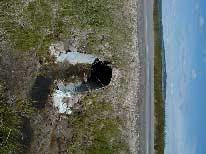
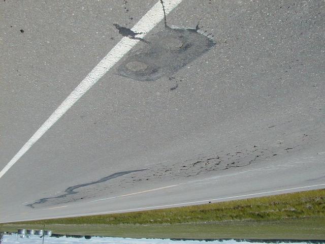
1 Alberta Transportation Central Region #401, Street Red Deer, Alberta T4N 6K8 June 25, 2001 Mr. Melvin Mayfield, P.Eng. Construction Services Coordinator Dear Mr. Mayfield: Central Region Landslide Assessment Site C20 SH771:02 Pavement Distress 2001 Annual Inspection Report Alberta Transportation has initiated a process of risk management at site-specific slope movement sites that includes a 3-ring binder document control system. This Annual Inspection report forms Section B of the document control system for the above site. The annual site inspection was undertaken on June 12, 2001 by Mr. Darren Ratcliffe, P.Eng., of Klohn Crippen Consultants Ltd. Mr. Ratcliffe was accompanied by Mr. Melvin Mayfield, P.Eng., and Mr. Fred Cheng, P.Eng., of Alberta Transportation. This report was prepared by Klohn Crippen Consultants Ltd. for Alberta Transportation Central Region under Contract No. CE053/ PROJECT BACKGROUND Following a recent site inspection on SH771:04 with Alberta Transportation and Lacombe County, an area of distressed pavement was noted. At the intersection of SH771:02 with the township road 41-0, about 2 km north of H20, standing water is present in the ditches and the pavement is beginning to fail due to the water and corresponding softening of the road base. The site plan is shown on Figure 1 and illustrated in the attached photographs. PA L- C20 Annual Report
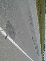
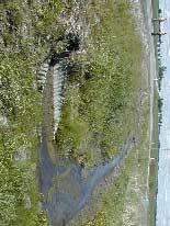
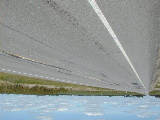
2 ALBERTA TRANSPORTATION CENTRAL REGION June 25, 2001 Landslide Site C20 Annual Inspection Report 2. SITE OBSERVATIONS Highway 771:02 runs on a north-south alignment. The surrounding terrain is very flat, but there is a slight fall in grade to the west. As shown on Figure 1, the drainage for the site is northward along the east ditch on the south side of Twp Rd 41-0 and then westward through a 0.9 m diameter CSP culvert under SH771 and then westward, south of Twp Rd Some flow continues northwards on the east side of SH771 and passes under the local road through a 0.6 m diameter CSP culvert. Significant areas of standing water were observed in the east ditch of SH771. A small dam in the ditch was contributing to the ponded water, although it is expected that the regional groundwater table is relatively high. The ditch on the west side of SH771 was dry. Numerous cracks and depressions were observed in the pavement over a length of about 150 m. The distress in the pavement generally corresponded with the standing water in the ditches. 3. SITE ASSESSMENT It is considered that the poor drainage in the area has contributed to the softening and distress of the highway structure. There is likely also some damage as a result of frost action. Based on the risk level criteria provided by Alberta Transportation, a risk rating of 9 has been assigned to this site. This is based on a probability factor of 9 for an active feature, and a consequence factor of 1 as closure of the highway is unlikely. 4. RECOMMENDATIONS The following recommendations are provided: A survey of the area should be undertaken to determine the relative ditch grades, etc. The survey would encompass an approximate area of 200 m by 20 m. Using the survey data, a design would be developed to lower the ditch grade to provide positive drainage to the west. As part of the work, the 0.9 m diameter culvert under SH771 will likely have to be lowered. PA L- C20 Annual Report Page 2

3 ALBERTA TRANSPORTATION CENTRAL REGION June 25, 2001 Landslide Site C20 Annual Inspection Report Following the ditch remediation work, the highway should be repaved. An estimated cost for the survey and design work is about $6,000 to $7,000. A cost estimate for the construction work would be provided at this time. Please contact the undersigned if you have any questions regarding this report. Yours truly, KLOHN CRIPPEN CONSULTANTS LTD. Darren Ratcliffe, P.Eng. Senior Geotechnical Engineer Brian Rogers, P.Eng. Manager, Alberta PA L- C20 Annual Report Page 3
4 ALBERTA TRANSPORTATION CENTRAL REGION Landslide Site C20 Annual Inspection Report FIGURE PA L- C20 Annual Report

5
6
7
8


9 Looking south (note standing water in east ditch) Looking north from previous location Page 5 of 14


10 Looking north west side Looking north east side Page 6 of 14

11 Page 7 of 14


12 Water in east ditch following towards the cross culvert Page 8 of 14

13 0.9 m diameter culvert inlet on east side of highway Page 9 of 14

14 Culvert outlet on west side of highway. Note crack and heaving of pavement over pipe. Page 10 of 14


15 Depressions in pavement at intersection with Twp Rd 41-0 Page 11 of 14

16 Depressions in pavement at intersection with Twp Rd 41-0 Page 12 of 14


17 Depressions in pavement at north end of site (note test core holes) Culvert under Twp Rd 41-0 north end Page 13 of 14

18 Page 14 of 14
ATVANS Trail Assessment for Five Bridge Lakes Wilderness Area Report and Recommendation. December 28, Prepared by.
 ATVANS Trail Assessment for Five Bridge Lakes Wilderness Area Report and Recommendation December 28, 2011 Prepared by Peter Bush Background This report documents the results and recommendations of an all-terrain
Paeroa Ward Committee
 Report To: From: Paeroa Ward Committee Drainage Manager and District Engineer Date: 31 August 2012 File reference & attachments: 938480 Meeting date: 11 September 2012 Subject: Netherton School request
Alberta Transportation 2013 Request for Expression of Interest (RFEI) Awards
 Awards") Alberta Transportation 203 Request for Epression of Interest (RFEI) Awards Please note that the following lists were compiled for information purposes only. In the event that a discrepancy is present between
Alberta Transportation 203 Request for Epression of Interest (RFEI) Awards Please note that the following lists were compiled for information purposes only. In the event that a discrepancy is present between
Freymond Aggregates Quarry Bay Lake Rd., Twp. of Faraday
 Freymond Aggregates Quarry Bay Lake Rd., Twp. of Faraday Traffic Brief South Site Entrance Prepared by: Tranplan Associates PO Box 455 Lakefield, ON K0L 2H0 www.tranplan.com Prepared for: EcoVue Consulting
United States Department of the Interior National Park Service. Boundary Expansion Listed in National Register January 11, 2017
 NPS Form 10900-a (Rev. 8/2002) OMB No. 10240018 United States Department of the Interior National Park Service Boundary Expansion Listed in National Register January 11, 2017 National Register of Historic
Ditch flows slowly to the north
 Ditch flows slowly to the north Photo 1. Wetland DE: Looking west across Wetland DE from upslope. Ponded water, mucky mineral soils, and patches of emergent vegetation observed. Wetland DE appears to be
MUNICIPAL DISTRICT OF GREENVIEW NO. 16
 MUNICIPAL DISTRICT OF GREENVIEW NO. 16 Spring Flooding Impacted Roads in Greenview Master List Total Flood Locations in All Areas: 34 hazards, 17 roads closed as of May 4, 2018 New Fish Creek Range Road
STAFF REPORT TO COUNCIL
 i CITYOF PRINCE GEORGE STAFF REPORT TO COUNCIL 1100 Patricia Blvd. I Prince George, BC, Canada V2L 3V9 I www.pri ncegeorge.ca DATE: January 24, 2017 TO: NAME AND TITLE: SUBJECT: MAYOR AND COUNCIL Dave
Appendix 4 St. Charles Basin
 Appendix 4 St. Charles Basin The St. Charles hurricane protection system (HPS), shown in Figure 1, was designed as part of the Lake Pontchartrain, LA, and Vicinity Hurricane Protection Project. The St.
RIO VISTA MUNICIPAL AIRPORT
 DRAINAGE TECHNICAL MEMORANDUM RIO VISTA MUNICIPAL AIRPORT RIO VISTA, CALIFORNIA Prepared for: City of Rio Vista 1 Main Street Rio Vista, CA 94571 (707) 374-5337 Prepared by: August 2012 Copyright 2012
KP Lasnaya 1 River
 KP 370.2 Lasnaya 1 River The Lasnaya 1 River crossing is protected by Reno mattings and a gabion wall on the north bank (Photo 1). The south bank consists of natural river gravel deposits on top of Reno
Off-Site Solutions. CPM Headwalls. Concrete for Life
 Off-Site Solutions CPM Headwalls Concrete for Life Welcome to CPM CPM is a market leading manufacturer of concrete products with production facilities across the UK. This combined with a network of specialist
Section CHAPTER 1 LEGAL STATUS OF WATER COURSES NOVA SCOTIA DEPARTMENT OF NATURAL RESOURCES REGIONAL OFFICES
 Section 17 17.1.1. CHAPTER 1 LEGAL STATUS OF WATER COURSES Environment and Labour The Province of Nova Scotia has possession of all water courses, and the law requires that you obtain approval prior to
January 19, 2018 Project No C Via
 Mr. Thomas McDonald, P.E. Professional Engineer II (C/E) Water Management NYS Canal Corporation 30 S Pearl Street Albany, NY 12207 January 19, 2018 Project No. 16-5719C Via email: thomas.mcdonald@canals.ny.gov
LANDER COUNTY RAIL ASSESSMENT NOVEMBER 2006
 of hydrologic features. A substantial proportion of the land between and north of the railroad tracks contain wetlands, as identified by the US Fish and Wildlife Service National Wetlands Inventory (NWI).
This economic statement provides analysis with respect to land at Tarneit North, and has been prepared on behalf of Amex Corporation.
 Memorandum To: From: Amex Corporation c/- Greg Wood, Tract Consultants Matthew Lee Cc: Date: 12 June 2013 Subject: Economic Statement for Amex site Tarneit North PSP Dear Greg, This economic statement
Agenda Report. Spruce Street Outlet Drainage Improvements Tower Road Relief Sewer
 Agenda Report Subject: Prepared By: Spruce Street Outlet Drainage Improvements Tower Road Relief Sewer Steven M. Saunders, Director of Public Works/Village Engineer Date: August 12, 2012 On March 8, 2012
Section 3-04 Cross Sectional Elements TABLE OF CONTENTS. INTRODUCTION...3 General...3 Exhibit 1-Cross-Sectional Elements...3
 Section 3-04 Cross Sectional Elements TABLE OF CONTENTS INTRODUCTION...3 General...3 Exhibit 1-Cross-Sectional Elements...3 CROSS-SECTIONAL ELEMENTS...3 Traveled Way...3 Shoulder...3 Surfacing Taper...3
PennDOT Interstate Work next week March 30-April 3:
 PennDOT Interstate Work next week March 30-April 3: Interstate 80 Interstate 81 DELAYS THIS WEEK: Exit 256 to the Schuylkill County line. Eastbound & Westbound. Bridge cleaning Monday (3/30), Tuesday (3/31)
EXPLANATORY STATEMENT
 THE LONDON TO FISHGUARD TRUNK ROAD (A40) (PENBLEWIN TO SLEBECH PARK IMPROVEMENT) ORDER 200- AND THE LONDON TO FISHGUARD TRUNK ROAD (A40) (PENBLEWIN TO SLEBECH PARK IMPROVEMENT SIDE ROADS) ORDER 200-1.
9 CONSTRUCTION OF BATHURST STREET FROM GREEN LANE WEST TO SOUTH OF HIGHWAY 11, TOWN OF EAST GWILLIMBURY AND TOWNSHIP OF KING
 Clause No. 9 in Report No. 9 of Committee of the Whole was adopted, without amendment, by the Council of The Regional Municipality of York at its meeting held on May 15, 2014. 9 CONSTRUCTION OF BATHURST
Photographic Log Client: Project Number: Site Location: Site Name: Photograph ID: Date: Location: Direction: Comments: Photograph ID:
 Photograph ID: 1 west View of one of the monitoring well and the large parking lot on the south side of Center Street. Photograph ID: 2 Monitoring well located in the middle of the parking lot located
Hospital Link Project Project Update Winter 2018
 Hospital Link Project Project Update Winter 2018 General The project provides a link from Riverside Drive and the Transitway to the Hospital Link Road. Construction of the Hospital Link facility is open
Design Considerations For Accessible Parks & Trails
 Design Considerations For Accessible Parks & Trails Measuring Up: Campbell River 2008 Dave Calver Consulting City of Campbell River Legacies Now: Measuring Up Design Guidelines Design Considerations for
Attachment D: PHOTO LOG CITY OF ARCATA RAIL-WITH-TRAIL CONNECTIVITY PROJECT
 01051-09004 Attachment D: PHOTO LOG CITY OF ARCATA RAIL-WITH-TRAIL CONNECTIVITY PROJECT DRAFT: June 30, 2010 Applicant: City of Arcata 736 F Street Arcata, CA 95521 Phone (707) 825-2154 Prepared by: Winzler
2. STAKEHOLDER FEEDBACK // What We Heard
 1. QUARRY ROAD TRAIL // Welcome to the Information Session PROJECT DESCRIPTION WHY WE ARE HERE Quarry Road Trail is a popular commuter trail and recreational area for Calgarians. 1. To report citizen feedback
Head Pond Connector Trail Final Report Project Area: From Head Pond in Berlin to Rt. 110B in Milan
 Milan Trail Huggers ATV Club P.O. Box 42 Milan, NH 03588 Maintaining Trails in Milan, Stark and Dummer Head Pond Connector Trail Final Report Project Area: From Head Pond in Berlin to Rt. 110B in Milan
SH73 Route Security Strategic Study Project Summary
 November 2009 SH73 Route Security Strategic Study Project Summary Managing Route Security from Springfield to Aickens STATE HIGHWAY 73 SPRINGFIELD TO AICKENS ROUTE SECURITY STRATEGY CONSULTATION 1. Introduction
PAVEMENT CONDITION REPORT
 PAVEMENT CONDITION REPORT Department of Facility Maintenance December 2012 TABLE OF CONTENTS Executive Summary...1 Figure 1. Inputs to Pavement Condition Index...1 Figure 2. Summary Oahu Pavement Condition
SH6 Route Security Strategic Study Project Summary
 Ocber 2009 SH6 Route Security Strategic Study Project Summary Managing Route Security from Buller Gorge Haast Pass STATE HIGHWAY 6 BULLER GORGE TO HAAST PASS ROUTE SECURITY STRATEGY CONSULTATION 1. Introduction
2.0 Resource Management Goals of Agencies with Jurisdiction Over the Resource to be Studied
 Study 9.1 PRIMARY PROJECT ROADS AND TRAILS August 2011 1.0 Project Nexus Yuba County Water Agency s (YCWA or Licensee) continued use, operation and maintenance (O&M) of s (Project) Primary Project Roads
Aloha Township Local Road Ratings Report for 2018
 Cheboygan County Road Commission Aloha Township Local s Report for 2018 The goal of the Road Commission is to use Asset Management Strategies when planning projects for the roads under the jurisdiction
Sandown Planning Board Minutes July 20, 2010
 1 2 3 4 5 6 7 8 9 10 11 12 13 14 15 16 17 18 19 20 21 22 23 24 25 26 27 28 29 30 31 32 33 34 35 36 37 38 39 40 41 42 43 44 45 46 47 48 Sandown Planning Board Minutes July 20, 2010 Date: July 20, 2010 Place:
K SIGNAGE & TRAFFIC CONTROL. Table of Contents
 Table of Contents K1. ACCOMMODATION OF TRAFFIC... 1 K2. MINIMUM CONSTRUCTION SIGNING... 1 K3. SUBDIVISION SIGNS... 2 K4. TRAFFIC CONTROL DEVICES... 2 K4.1 Traffic Signs Regulations... 2 K4.2 Materials...
Thornton Water Project. Larimer County Route Study and Project Update September 12, 2017
 Thornton Water Project Larimer County Route Study and Project Update September 12, 2017 Purpose of Meeting Provide information on the Thornton Water Project Present the results of the pipeline routing
Morristown Municipal Airport Runway 5-23 Rehabilitation Environmental Assessment
 1.0 INTRODCTION Morristown Municipal Airport (hereinafter referred to as MM or Airport ) is a busy general aviation reliever airport owned by the Town of Morristown and operated by DM AIRPORTS, LTD. (hereinafter
Chapter 2: Entire US287 Corridor
 Chapter 2: Entire US287 Corridor The US287 Study Area spans four incorporated jurisdictions and two counties. Due to the length and density of infrastructure along the US287 Study Area, corridor-wide maps
Metro District 1500 W. County Road B 2 Roseville, MN Date: July 17, 2018
 Metro District 1500 W. County Road B 2 Roseville, MN 55113 3174 Date: July 17, 2018 Ryan Hixson FHWA, Area Engineer Federal Highway Administration 380 Jackson Street, Suite 500 St. Paul, Minnesota 55101
Planning Wildlife Crossings in Canada's Mountain Parks SESSION: Highway Mitigation: new insights for practitioners
 Planning Wildlife Crossings in Canada's Mountain Parks ID95 SESSION: Highway Mitigation: new insights for practitioners Trevor Kinley, Project Manager Lake Louise Yoho Kootenay Field Unit, Parks Canada
KENNESAW MOUNTAIN TRAIL CLUB WORKDAY
 WORKDAY 4-14-18 1 Trail ambassadors or others see next page. 1 TOOLS HERE 2 1 7 20 Work for 4-14-18 will again be on the lower portion of the Mountain Trail below the fire road. Due to safety considerations,
TRAFFIC ALERT FOR OCTOBER 15-19, 2018 Highway Work Zones in the Staunton District
 RELEASE: IMMEDIATE October 12, 2018 CONTACT: Sandy Myers 540-332-9201 (office) STA18 167 540-292-2500 (cell) Sandy.Myers@VDOT.virginia.gov Ken Slack 540-332-9264 (office) 540-414-5670 (cell) Ken.Slack@VDOT.virginia.gov
CALL TO ORDER: Chair Haines called the meeting to order at approximately 9:30 a.m. Regular Public Works Meeting July 19, 2016
 PRESENT: ABSENT: Chair Kevin Haines; County Councillors Larry Speers, Denis Willcott, Christi Bilsky, Kevin Haines, Jack Dowhaluk, Paul Ponich, Larry Armfelt; County Manager Ryan Maier; Director of Infrastructure
PORTISHEAD BRANCH LINE PRELIMINARY ENVIRONMENTAL INFORMATION REPORT VOLUME 4 APPENDIX Water Receptors
 PORTISHEAD BRANCH LINE PRELIMINARY ENVIRONMENTAL INFORMATION REPORT APPENDIX 17. 3 Water Receptors Contents Section Page 1 Water Receptors... 1-1 1.1 Surface Water Features/Receptors in the Study Area
PUBLIC INFORMATION SESSION #2
 Highway 16, Highway 779 to Kapasiwin Road, Planning Study PUBLIC INFORMATION SESSION #2 Wednesday June 20, 2012 4 to 8 pm HIGHWAY 16 Highway 779 to Kapasiwin Road Functional Planning Study Blueberry Community
Transportation System Preservation R & D Needs Statements
 Transportation System Preservation R & D Needs Statements Asset Management 1) Development of a Process for Estimating the Remaining Service Life (RSL) for Transportation Infrastructure 2) Improved Decision
Prequalified Service Provider Registry
 Engineering and Operations Division and Water Management and Structures Division For Internal and External Use Managed by: Engineering Services Contract Engineer Contract Services Branch Effective: 21
GILBERT & WEST TOWN INTERCOUNTY DRAIN Windsor Township, Eaton County and City of Lansing, Delhi Township, Ingham County, Michigan
 GILBERT & WEST TOWN INTERCOUNTY DRAIN Windsor Township, Eaton County and City of Lansing, Delhi Township, Ingham County, Michigan PRELIMINARY ENGINEERING REPORT Abigail Eaton, Chair Intercounty Drains
Crossing the Keweenaw Waterway in an Emergency with a U.S Army Floating Bridge
 Crossing the Keweenaw Waterway in an Emergency with a U.S Army Floating Bridge Photo: John Kiefer William Leder, Adjunct Professor (Ret.) Department of Civil and Environmental Engineering Contributions
ACORNS PROJECTS LIMITED
 ACORNS PROJECTS LIMITED A4 London Road, M4 J5 to Sutton Lane, Slough, Berkshire Combined Stage 1 and 2 Road Safety Audit For Slough Borough Council Prepared by Acorns Projects Limited Safety Traffic Project
Attachment G STREAM IMPACTS. Ridge Road Extension Alternatives Analysis
 Attachment G STREAM IMPACTS for: Ridge Road Extension Alternatives Analysis PREPARED FOR: Pasco County Engineering Services Department PREPARED BY: NV5, INC. 6989 E. FOWLER AVENUE TAMPA, FLORIDA 33617
MARSHALL Subdivision. Township of Springwater, County of Simcoe. Traffic Brief for: Ontario Inc. Type of Document: Final Report
 MARSHALL Subdivision Township of Springwater, County of Simcoe Traffic Brief for: 489469 Ontario Inc. Type of Document: Final Report Project Number: JDE 1521 Date Submitted: October 19 th, 2016 10 / 19
2017 Armstrong County Outreach
 Armstrong County Maintenance Brent Piccola Acting County Maintenance Manager Randy Quinn Acting Assistant County Manager Luke Crawford Assistant County Manager Ernie Cascino Acting Assistant County Manager
Stephanie Sinnott, Executive Director, Finance, Office of the City Manager
 Public Report To: From: Finance Committee Stephanie Sinnott, Executive Director, Finance, Office of the City Manager Paul D. Ralph, BES, RPP, MCIP, Commissioner, Development Services Department Report
Morristown Municipal Airport Runway 5-23 Rehabilitation Environmental Assessment
 2.0 PURPOSE AND NEED The Purpose and Need Statement in a NEPA document is a formal declaration of the overall goals and objectives of a proposed project. This statement documents the justification for
SEGMENT ASSESSMENT REPORT
 2017 SEGMENT ASSESSMENT REPORT SEGMENT 3: MT ROSE / TAHOE MEADOWS TO SPOONER SUMMIT REPORT SUMMARY This report is a compilation of information collected on the Tahoe Rim Trail during assessments performed
Lake Dunstan Trail Project - Geotechnical Review
 11 July 2018 Oli Monthule-Mcintosh Planning Officer Central Otago District Council 1 Dunorling Street PO Box 122 Alexandra WSP Opus Alexandra Office Tarbert Buildings, 69 Tarbert Street PO Box 273, Alexandra
Appendix E. System Issues
 Appendix E System Contents Page System... E-1 E.1 Introduction...E-1 E.2 Existing Model - System...E-2 E.2.1 Location: Country Ridge Collector, at Queensgate Drive...E-2 E.3 Committed Model - System...E-3
Runway Roughness Evaluation- Boeing Bump Methodology
 FLIGHT SERVICES Runway Roughness Evaluation- Boeing Bump Methodology Michael Roginski, PE, Principal Engineer Boeing Airport Compatibility Engineering ALACPA X Seminar, Mexico City, Mexico September 30-
Runway Roughness Evaluation- Boeing Bump Methodology
 FLIGHT SERVICES Runway Roughness Evaluation- Boeing Bump Methodology Michael Roginski, PE, Principal Engineer Boeing Airport Compatibility Engineering ALACPA X Seminar, Mexico City, Mexico September 3-
FDOT Treasure Coast Traffic Impact Report March 25 through April 1, 2016
 March 25, 2016 Chuck McGinness, 954-777-4302 chuck.mcginness@dot.state.fl.us FDOT Treasure Coast Traffic Impact Report March 25 through April 1, 2016 TREASURE COAST Construction and maintenance-related
FHWA P/N Guidelines. Corridor Relationship. Highway 22 Segment 1 - US 169 to CSAH 2 Relevance / Documentation of Need
 Highway 22 Segment 1 - US 169 to CSAH 2 Vehicle Mobility Congestion Intersection Congestion Existing Conditions - Based on Highway Capacity Manual methodology, corridor level of service is currently LOS
VDOT HOT SPOTS IN THE FREDERICKSBURG DISTRICT
 RELEASE: IMMEDIATE Aug. 10, 2018 CONTACT: Darragh Frye 540 899 4119 (office) 540 907 8409 (cell) Darragh.Frye@VDOT.Virginia.gov VDOT HOT SPOTS IN THE FREDERICKSBURG DISTRICT August 12 August 18, 2018 All
Municipality of Strathroy- Caradoc
 Municipality of Strathroy- Caradoc Page 1 of 2 Staff Report Directed to: Mayor Vanderheyden and Members of Council Meeting Date: Sept. 2/14 Prepared by: Department: Subject: Angela Toth, Director, Corporate
Derry Hill and Bingley Road, Menston. Accidents waiting to happen.
 Derry Hill and Bingley Road, Menston. Accidents waiting to happen. School Bus unable to pass on Hawksworth Drive References: Derry Hill - 10/04551/MAF Bingley Road - 10/06229/MAO Bingley Road - 11/05691/OUT
SECTION 55A1 ROBINSON TOWNSHIP IN WASHINGTON COUNTY
 WEEK ENDING FEBRUARY 1, 2019 SECTION 55A1 ROBINSON TOWNSHIP IN WASHINGTON COUNTY Contractor: Independence Excavating Inc. 1. Work Shift Day shift (M-F), with Saturday as a makeup day. 2. Traffic The new
Lake Manitoba Lake St. Martin
 Lake Manitoba Lake St. Martin Outlet Channels Public Information Session June 29, 2017 July 13, 2017 Background & History 2011 Spring Flood Event High flows recorded on most streams and rivers in the Assiniboine
CENTER PIVOT TRACK MANAGEMENT OPTIONS
 Proceedings of the 28th Annual Central Plains Irrigation Conference, Kearney, Nebraska, February 23-24, 2016 Available from CPIA, 760 N. Thompson, Colby, Kansas CENTER PIVOT TRACK MANAGEMENT OPTIONS Steven
PRIORITIES COMMITTEE MEETING
 PRIORITIES COMMITTEE MEETING Meeting Date: 05/13/14 Agenda Item #: 13.1 Northeast Anthony Henday Drive Update Report Purpose To update the Priorities Committee on the progress of the Northeast Anthony
Attachment No. 20 RRLRT No. 1. Committee. Busway Grade Crossings STATUS/DATE OF ACTION
 Attachment No. 20 RRLRT No. 1 TECHNICAL COMMITTEE: Railroad / Light Rail Transit Technical Committee TOPIC: Busway Grade Crossings STATUS/DATE OF ACTION RRLRT TC Draft: 06/23/2011 RRLRT TC Approval: 06/27/2014
SAND HILL RIVER WATERSHED DISTRICT November 1, 2016
 SAND HILL RIVER WATERSHED DISTRICT November 1, 2016 1. Attendance: Chairman Stuart Christian called the November 1, 2016 meeting to order at 8:10 AM at the District Office. Other managers present were
NOTICE OF REQUIREMENT: NZ TRANSPORT AGENCY: SH6 TARAMAKAU BRIDGE PROJECT
 1 July 2016 Planning Manager Westland District Council 36 Weld Street HOKITIKA Attn Alex Dunn Dear Alex NOTICE OF REQUIREMENT: NZ TRANSPORT AGENCY: SH6 TARAMAKAU BRIDGE PROJECT On 15 June 2016 you issued
Installation Instructions
 Installation Instructions Hex Sierra TopTec Products, LLC 7061 Highway 221 Moore, SC 29369 Phone: (800) 845-2830 Fax: (800) 921-7750 e-mail: sales@toptecproducts.com www.toptecproducts.com 2004 TopTec
EAST DON TRAIL ENVIRONMENTAL ASSESSMENT. Community Liaison Committee Meeting #3 July 15, :30 to 8:30 pm Flemingdon Park Library
 EAST DON TRAIL ENVIRONMENTAL ASSESSMENT Community Liaison Committee Meeting #3 July 15, 2013 6:30 to 8:30 pm Flemingdon Park Library Agenda 1. Welcome 2. Housekeeping and Updates a) Housekeeping b) CLC
ENHANCE RUNWAY SAFETY. (Presented by the Secretariat)
") International Civil Aviation Organization 27/07/12 rth American, Central American and Caribbean Office (NACC) Twenty-fourth Meeting of Directors of Civil Aviation of the Eastern Caribbean (E/CAR/DCA/24)
International Civil Aviation Organization 27/07/12 rth American, Central American and Caribbean Office (NACC) Twenty-fourth Meeting of Directors of Civil Aviation of the Eastern Caribbean (E/CAR/DCA/24)
Public Notice July 14, 2017
 Public Notice July 14, 2017 PROPOSED IMPLEMENTATION OF PFC 13 NOTICE TO AIR CARRIERS AND CONSULTATION MEETING Implementation of PFC On June 14, 2017 the Omaha Airport Authority provided written notice
Appendix B PAVEMENT CONDITION AND HISTORY
 Appendix B PAVEMENT CONDITION AND HISTORY The Sunport maintains a pavement management program (PMP) in order monitor the condition of pavements and to plan for repair/replacement in a timely manner. The
March 4, Mr. H. Dale Hemmerdinger Chairman Metropolitan Transportation Authority 347 Madison Avenue New York, NY Re: Report 2007-F-31
 THOMAS P. DiNAPOLI STATE COMPTROLLER 110 STATE STREET ALBANY, NEW YORK 12236 STATE OF NEW YORK OFFICE OF THE STATE COMPTROLLER March 4, 2008 Mr. H. Dale Hemmerdinger Chairman Metropolitan Transportation
THE WELSH MINISTERS STATEMENT OF REASONS
 THE WELSH MINISTERS The Welsh Ministers (The M4 Motorway (Junction 23 (East of Magor) to West of Junction 29 (Castleton) and Connecting Roads) and The M48 Motorway (Junction 23 (East of Magor) Connecting
Kansas City, Missouri (direct, non-stop destination from RSW)
") Kansas City, Missouri (direct, non-stop destination from RSW) Kansas City straddles the Missouri-Kansas state line, sometimes causing travelers to wonder which state they are in. Here are a few tips to
Kansas City, Missouri (direct, non-stop destination from RSW) Kansas City straddles the Missouri-Kansas state line, sometimes causing travelers to wonder which state they are in. Here are a few tips to
MORGAN CREEK GREENWAY Final Report APPENDICES
 APPENDICES MORGAN CREEK GREENWAY Appendix A Photos of Existing Conditions in Trail Corridor Photos of existing conditions Main trail corridor - February 2009 Photos of existing conditions south bank Morgan
CorriPipe. Fittings & Accessories
 CorriPipe Fittings & Accessories CorriPipe JFC CorriPipe is a twinwall drainage pipe made from HDPE plastic and is manufactured by twin extrusion process in which the two layers are simultaneously extruded
Principle Causes of Dam Failures. Structural failure. Cracking. Stability failure. BIA Summer Water Resources Training Dam Safety Inspections
 BIA Summer Water Resources Training Dam Safety Inspections Principle Causes of Dam Failures Part 2 Dam Failures July 28, 2012 Presented by Michael Johnson, Ph.D., P.E. Overtopping Structural failure Stability
FDOT Treasure Coast Traffic Impact Report October 9 through October 16, 2015
 From: Kathleen Dempsey To: Kathleen Dempsey Subject: FDOT Treasure Coast Traffic Report 10 09 15 through 10 16 15 Date: Friday, October 09, 2015 2:10:36 PM Attachments: image003.png CR 714_Median Construction
BENINGTON PARISH COUNCIL
 BENINGTON PARISH COUNCIL e-mail: clerk.beningtonpc@yahoo.co.uk Benington Parish Council Meeting 21 September 2016 8.00 pm Benington School Minutes Present: R Bott (Chair) K Daniel B Morcom M Hughes In
300 ft. 5/8 Hose wagon
 300 ft. 5/8 Hose wagon Model 95956 Assembly And Operation Instructions Due to continuing improvements, actual product may differ slightly from the product described herein. (Garden hose is not included).
Southern Beltway Projects Summary
 Southern Beltway Projects Summary The Pennsylvania Turnpike Commission is proposing the construction of a 30-mile, tolled fourlane limited-access highway, known as the Southern Beltway that will be located
Report. Recommendation: Mayor and Councillors. To: District Engineer and Roading Manager. From: Date: 11 th April 2012
 Report To: From: Mayor and Councillors District Engineer and Roading Manager Date: 11 th April 2012 File reference: Portfolio holder: Document: 873742 Appendix A: 873811 Appendix B: 871432 Councillor Harris
VIA E MAIL November 21, 2008
 ERICA M. HAMILTON COMMISSION SECRETARY Commission.Secretary@bcuc.com web site: http://www.bcuc.com SIXTH FLOOR, 900 HOWE STREET, BOX 250 VANCOUVER, B.C. CANADA V6Z 2N3 TELEPHONE: (604) 660 4700 BC TOLL
Geoscape Toronto The Oak Ridges Moraine Activity 2 - Page 1 of 10 Information Bulletin
 About 13,000 years ago as the Laurentide Ice Sheet melted, glacial meltwater accumulated between the ice sheet and the Niagara Escarpment. This formed a lake basin into which gravel and sand were deposited.
AGENDA ITEM I-6 Public Works
 AGENDA ITEM I-6 Public Works STAFF REPORT City Council Meeting Date: 8/6/2018 Staff Report Number: 18-150-CC Informational Item: Update on the Willow Road and highway 101 interchange construction, upcoming
FDOT Treasure Coast Traffic Impact Report June 19 through June 26, 2015
 June 19, 2015 Chuck McGinness, 954-777-4302 chuck.mcginness@dot.state.fl.us FDOT Treasure Coast Traffic Impact Report June 19 through June 26, 2015 TREASURE COAST Construction and maintenance-related lane
Proposed Arthurs Point Special Housing Area. Housing Accords and Special Housing Areas Act Expression of Interest
 Proposed Arthurs Point Special Housing Area Housing Accords and Special Housing Areas Act 2013 Expression of Interest 1.0 APPLICANT The applicant for the proposed Arthurs Point Special Housing Area is
FDOT Treasure Coast Traffic Report through
 FDOT Treasure Coast Traffic Report 02 26 16 through 03 04 16 Kathleen Dempsey Fri 2/26/2016 2:56 PM To:Kathleen Dempsey ; 1 attachment 355 KB CR 714_Median Access Modifications.pdf;
Welcome KROSNO CREEK DIVERSION PROJECT CLASS ENVIRONMENTAL ASSESSMENT
 Welcome KROSNO CREEK DIVERSION PROJECT PUBLIC INFORMATION CENTRE # 1 Tonight s Presentation Study Overview Background Existing Conditions Alternative Solutions Preliminary Preferred Solution Next Steps
TRAFFIC ALERT FOR FEBRUARY 11-15, 2019 Highway Work Zones in the Staunton District
 RELEASE: IMMEDIATE February 8, 2019 CONTACT: Sandy Myers 540-332-9201 (office) STA19 027 540-292-2500 (cell) Sandy.Myers@VDOT.virginia.gov Ken Slack 540-332-9264 (office) 540-414-5670 (cell) Ken.Slack@VDOT.virginia.gov
Watab Town Board Meeting Minutes of September 2, 2014
 Watab Town Board Meeting Minutes of September 2, 2014 The regular monthly meeting of the Watab Town Board was held on Tuesday, September 2, 2014 at the Watab Town Hall. Chairman Ed Kacures Jr. called the
Foam Systems Engineering Design Manual
 Foam Systems Engineering Design Manual CONTENTS Foam Systems Engineering Design Manual Haardous Chemical & Product Data 1 Foam Concentrate Induction Systems 2 Protection of Fuel Storage Tanks 3 Foam Base
Runway Roughness Evaluation- Boeing Bump Methodology
 FLIGHT SERVICES Runway Roughness Evaluation- Boeing Bump Methodology Michael Roginski, PE, Principal Engineer Boeing Airport Compatibility Engineering ALACPA XI Seminar, Santiago, Chile September 1-5,
The Cleo s Bath North Side Hike
 The Cleo s Bath North Side Hike This hike is a cross-country hike from Pinecrest Lake to the north side of Cleo s Bath. It is quieter and much less crowded than the normal route, which goes up the south
FORT WORTH DISTRICT. Springtown Area Projects. Loyl C. Bussell, P.E. Acting District Engineer. Thursday, February 8, 2018 Date.
 FORT WORTH DISTRICT Springtown Area Projects Loyl C. Bussell, P.E. Acting District Engineer Photo by Liam Frederick Footer Text Thursday, February 8, 2018 Date Maintaining a Safe System TxDOT is responsible