Crossing the Keweenaw Waterway in an Emergency with a U.S Army Floating Bridge
|
|
|
- Derrick Cummings
- 5 years ago
- Views:
Transcription

 Department of Civil and Environmental Engineering")
1 Crossing the Keweenaw Waterway in an Emergency with a U.S Army Floating Bridge Photo: John Kiefer William Leder, Adjunct Professor (Ret.) Department of Civil and Environmental Engineering Contributions by Brent Cousino, BSENVE, MSCE, are acknowledged
2 Presentation Objectives Context The Keweenaw Peninsula Explain the importance an emergency IRB** crossing How the preferred crossing location was selected Details of the proposed crossing infrastructure Traffic flow analysis Identify next steps leading to implementation ** Improved Ribbon Bridge

3 Keweenaw Waterway Location Hancock March 3, 1865 Rivers and Harbors Act 3 Houghton


4 Portage Lake Lift Bridge Copper Island Photo: Adam Johnson Photo: Adam Johnson 4 Opened in 1959 Only roadway link between Copper Island and the mainland 21,000 people live north of the bridge 27,000 daily crossings; 2.5 times the traffic on the Mackinac Bridge Vital for emergency services, economy, institutions, and society
5 Why an Emergency Crossing is Vital Only vehicular link between Copper Island and the mainland Separation of key components of community Both hospitals and only airport located north of the bridge Food, fuel, medicine, and other essentials must flow north Mix of employers and employees on both sides Commerce and businesses on both sides Michigan Tech on south side, Finlandia on north side 5
6 Vulnerabilities What could happen? Electro-mechanical failure Failure in August 2010 put bridge out of operation for 3 hours Struck by a vessel Major roadway transportation accident and ensuing fire 6
7 Assessing the Risk Risk = Probability x Consequences The probability of occurrence is low But the consequences are very high Therefore, the risk must be addressed 7

8 Bridge Collision Ems River, Germany December Photo: Jan-Timo Häckel

9 Oakland Maze Bridge Fire California April Photo: Contra Costa Times

10 Gasoline Tank Truck Accident - Chassell February 2018 Photo: Daily Mining Gazette 4,500 gallon fuel spill
 U.S.")


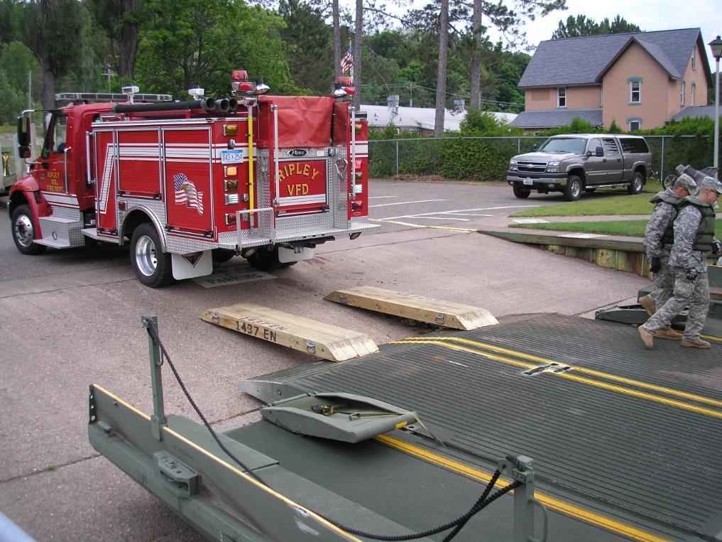
11 Improved Ribbon Bridge (IRB) U.S. Army modular floating bridge deployed by the Michigan National Guard Ramp bays 2 lanes by 22 feet long Interior bays 2 lanes by 22 feet long 704 foot maximum length 1437 MRBC Launch Rafting Full Enclosure Photo: asc.army.mil Photo: Primeportal.net Photo: Primeportal.net
12 Objectives of Keweenaw Waterway Emergency Deployment Robust rafting between Houghton and Hancock Operating like a ferry for vital movements (emergency vehicles, food, fuel, buses, and other high priority vehicles) Full enclosure at the preferred crossing location Used for public conveyances Two lane bridge for all types of highway vehicles
13 Lake Superior Water Levels 100 years of water level data Low water = feet (April 1926) High water = feet (October 1985) Range = 3.90 feet The full enclosure length exceeds the shore-to-shore distance Water will rise some distance up the on-shore access ramp 1 2
14 Lake Superior Water Levels Cross Sections at Lily Pond 475 feet Waterway Cross Section 400 feet 8% slope Low Water Level IRB Floating on Water 572 feet Waterway Cross Section 400 feet High Water Level

15 Lake Superior Water Levels Houghton County Marina
16 Three Potential Crossing Locations

17 South Entry Narrowest shore-shore span = 530 ft. Few IRB bays for rafting 82 mile round trip Energy use and emissions Existing roads not highly developed No publicly owned land on either side Photo: USACE Ruled Out

18 Downtown Houghton and Hancock Narrowest shore-shore span = 540 ft. Few IRB bays for rafting Crossing would run through historic Quincy Smelting Works Full enclosure could impede rafting Problematic road geometry Potential traffic impacts in downtown areas Ruled Out

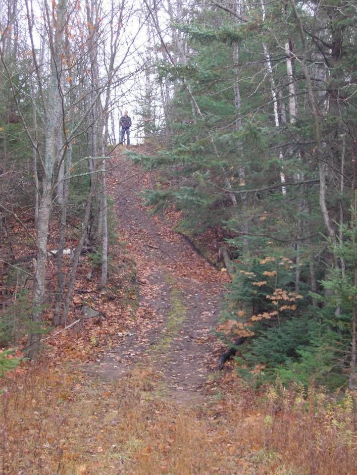
19 North Entry Shortest shore-shore span of 400 feet Almost all of land is publicly owned Two potential crossing sites N Photo: USACE
20 North Entry Alternative 1 40 mile round trip Private property on west side Unacceptable access road grades on west side Concern about high waves Deep cuts for access roads Makes snow removal challenging High erosion potential No wetlands, but significant environmental impacts due to excavation N Ruled Out
21 Alternative 1 Hill

22 Alternative 1 Details Hill
23 North Entry Alternative 2 36 mile round trip Takes advantage of existing roads West Stanton Twp. Boat Launch East two track off of M-203 Acceptable road profiles Reduced waves Minimal total wetland impacts N Preferred Site
24 Preferred Alternative West Side Uses existing Stanton Twp. Boat Launch Access Road Land is owned by Stanton Twp. or U.S.A. 90 foot long by 50 foot wide concrete ramp at 8% Modifications to steel sheet pile revetment required New 85 foot long access road Total wetland impact = 7,050 ft 2 (0.16 acres)

25 Preferred Alternative West Side Uses existing Stanton Twp. Boat Launch Access Road Land is owned by Stanton Twp. or U.S.A. 90 foot long by 50 foot wide concrete ramp at 8% Modifications to steel sheet pile revetment required New 85 foot long access road Total wetland impact = 7,050 ft 2 (0.16 acres)

26 Preferred Alternative West Side
27 Preferred Alternative West Side


28 Ramp Construction Water inflated rubber membrane cofferdam Photos: Aqua Dam, Inc.
29 Preferred Alternative East Side Uses existing two track off of M-203 Widen to accommodate two lanes Crosses small slice of private property Crosses small wetland areas Two track is not considered wetland Culvert connects the two fragments Wetland impacts = 1,990 ft 2 (0.05 acres) Cleared grassy area that can be used for staging
30 Preferred Alternative East Side Uses existing two track off of M-203 Widen to accommodate two lanes Crosses small slice of private property Crosses small wetland areas Two track is not considered wetland Culvert connects the two fragments Wetland impacts = 1,990 ft 2 (0.05 acres) Cleared grassy area that can be used for staging

31 Preferred Alternative East Side Uses existing two track off of M-203 Widen to accommodate two lanes Crosses small slice of private property Crosses small wetland areas Two track is not considered wetland Culvert connects the two fragments Wetland impacts = 1,990 ft 2 (0.05 acres) Cleared grassy area that can be used for staging

32 Preferred Alternative East Side
33 Preferred Alternative East Side 8% slope ramp 2 9

34 Timber Transition


35 Timber Transition Must design for all angles of approach and departure Angle of 5.8 will accommodate all vehicles Timber transition design spans full width of lanes Can be tested at Lily Pond Boat Launch Both have 8% grades Source:
36 Theoretical IRB Traffic Flow Condition * Vehicle Spacing (feet) Max Speed (MPH) Capacity/Direction ** (autos per hour) Lift Bridge Volume (northbound autos) Normal 25 mph , % 1,238 Normal 15 mph % 1,238 Caution 5 mph % 1,238 Risk % 1,238 * Condition a function of wave height and weather as determined by 1437 th field commander. ** Based on theoretical calculations. Actual rates will be less. Measured Lift Bridge Traffic Volumes, 10/01/13, 4 to 5 pm All vehicle types Northbound Southbound All vehicle types 1,305 1,111 Autos only 1,238 1,054 Traffic volumes will be less during a lift bridge outage. How much?

37 First Step Permit Joint USACE/MDEQ Permit Application All required information is in the report

38 Next Steps Joint USACE/MDEQ Application 1437 th MNG exercise at Lily Pond Same 8% slope Develop operational plans Civil Engineering Design USACE Section 408 Design Review Secure grant funding MOUs and property acquisition U.S. Coast Guard Bridge Permit Application Lily Pond Boat Access Site
39 Thank You! plan the work work the plan Photo: John Kiefer
40 Acknowledgements Jack Dueweke and Chris Van Arsdale, Houghton County Emergency Measures Directors Sergeant First Class Justin Proulx, 1437 th MNG Senior Chief Ed Iverson, U.S. Coast Guard Station Portage John Paul Pietila, Traverse Engineering Jamey Markham, Stanton Township Supervisor Many others
HARBOR INFRASTRUCTURE INVENTORIES Erie Harbor, PA
 HARBOR INFRASTRUCTURE INVENTORIES Erie Harbor, PA Harbor Location: Erie Harbor is located on the southern shore of Lake Erie in the City of Erie, PA about 98 Miles southwest of Buffalo. Authority: River
The Galveston Seawall
 Coastal and Ocean Engineering ENGI.8751 Undergraduate Student Forum Faculty of Engineering and Applied Science, Memorial University, St. John s, NL, Canada. March, 2013 The Galveston Seawall Mark Harvey
5.1 Traffic and Transportation
 5.1 When it opens in 2009, the Bellevue Nickel Improvement Project will increase the number of vehicles able to travel through the study area, improve travel speeds, and improve safety by reducing the
PROGRESS PARK CONNECTOR
 PROGRESS PARK CONNECTOR Project No. 9999 098 R65, P102 ALTERNATIVES ANALYSIS 6 April 2015 Revised for updated dates PROGRESS PARK CONNECTOR ROAD ALTERNATIVES ALTERNATIVE # 1 West from the intersection
Treasure Island Supplemental Information Report Addendum
 1 1 1 1 0 1 0 1 0 1 Treasure Island Supplemental Information Report Addendum Introduction Purpose The purpose of this Supplemental Information Report (SIR) Addendum is to determine if the current land
COPPER HERITAGE TRAIL CONCEPTUAL PLAN 2011
 COPPER HERITAGE TRAIL CONCEPTUAL PLAN 2011 A Proposed 40 Mile Non-Motorized Rail Trail Route Connecting The Historic Communities Of the Copper Country Prepared For: Western Upper Peninsula Health Department
ACCESS INVENTORY AND IMPROVEMENT PLAN
 ACCESS INVENTOR AND IMPROVEMENT PLAN Prepared by: Western Upper Peninsula Planning & Development Region Financial Assistance for the project was provided, in part, by the Michigan Coastal Management Program,
Riverine Sand Mining/Scofield Island Restoration (BA-40)
") Riverine Sand Mining/Scofield Island Restoration (BA-40) Conference on Ecological and Ecosystem Restoration Kenneth Bahlinger, CPRA Project Manager July 31, 2014 committed to our coast committed to our
Riverine Sand Mining/Scofield Island Restoration (BA-40) Conference on Ecological and Ecosystem Restoration Kenneth Bahlinger, CPRA Project Manager July 31, 2014 committed to our coast committed to our
Lake Erie Commerce Center Traffic Analysis
 LOCATION: East of NYS Route 5 at Bayview Road Town of Hamburg Erie County, New York PREPARED BY: Wendel Companies 140 John James Audubon Parkway Suite 200 Amherst, New York 14228 January 2012 i ii Table
Georgetown-Lewes Rail/Trail Study. Rail/Trail Study: Cool Spring to Cape Henlopen State Park New Road Extension (House Resolution No.
 Georgetown-Lewes Rail/Trail Study Rail/Trail Study: Cool Spring to Cape Henlopen State Park New Road Extension (House Resolution No. 47) August 22, 2011 Presentation Outline Background Benefits Statewide
Section 3-04 Cross Sectional Elements TABLE OF CONTENTS. INTRODUCTION...3 General...3 Exhibit 1-Cross-Sectional Elements...3
 Section 3-04 Cross Sectional Elements TABLE OF CONTENTS INTRODUCTION...3 General...3 Exhibit 1-Cross-Sectional Elements...3 CROSS-SECTIONAL ELEMENTS...3 Traveled Way...3 Shoulder...3 Surfacing Taper...3
Derry Hill and Bingley Road, Menston. Accidents waiting to happen.
 Derry Hill and Bingley Road, Menston. Accidents waiting to happen. School Bus unable to pass on Hawksworth Drive References: Derry Hill - 10/04551/MAF Bingley Road - 10/06229/MAO Bingley Road - 11/05691/OUT
HARBOR INFRASTRUCTURE INVENTORIES Cleveland Harbor, OH
 HARBOR INFRASTRUCTURE INVENTORIES Cleveland Harbor, OH Harbor Location: Cleveland Harbor is located at the mouth of the Cuyahoga River on the southern shore of Lake Erie in the city of Cleveland, OH. Authority:
Transportation Improvement District (TID) Exercise New Castle County Unified Development Code
 Exercise New Castle County Unified Development Code") Transportation Improvement District (TID) Exercise New Castle County Unified Development Code Churchmans Crossing TID How should New Castle County deploy Transportation Improvement Districts (TIDs)? Site
Transportation Improvement District (TID) Exercise New Castle County Unified Development Code Churchmans Crossing TID How should New Castle County deploy Transportation Improvement Districts (TIDs)? Site
Santa Cruz Wharf Improvement Project. Briefing Paper. Prepared by City of Santa Cruz. for
 Santa Cruz Wharf Improvement Project Briefing Paper Prepared by City of Santa Cruz for U.S. Army Corps of Engineers Interagency Meeting 12 November 2014 Santa Cruz Wharf Improvement Project Constructed
U.S. Coast Guard - American Waterways Operators Safety Report National Quality Steering Committee
 Am erican Waterways Operators August 05, 2015 Established Safety Metrics U.S. Coast Guard - American Waterways Operators Safety Report National Quality Steering Committee Towing Industry Safety Statistics
Schoolcraft Township is located in northeast Houghton County. A portion of the township borders Keweenaw County and Lake Superior.
 COMMUNITY DESCRIPTION Schoolcraft Township is located in northeast Houghton County. A portion of the township borders Keweenaw County and Lake Superior. The township is largely rural but has one main population
Non-Motorized Transportation
 Non-Motorized Transportation Non-motorized facilities are important components to the transportation system. They provide an environmentally-friendly, low-cost mode of travel. Some of the facilities can
A. CONCLUSIONS OF THE FGEIS
 Chapter 11: Traffic and Parking A. CONCLUSIONS OF THE FGEIS The FGEIS found that the Approved Plan will generate a substantial volume of vehicular and pedestrian activity, including an estimated 1,300
CORPS OF ENGINEERS ALASKA DISTRICT Dredging Projects. Michael Tencza, PE Operations Project Manager November 4, 2015
 CORPS OF ENGINEERS ALASKA DISTRICT 2016 Dredging Projects Michael Tencza, PE Operations Project Manager November 4, 2015 US Army Corps of Engineers Building and Preserving Alaska s Future AWARDED CONTRACTS
U.S. Coast Guard - American Waterways Operators Annual Safety Report
 American Waterways Operators U.S. Coast Guard - American Waterways Operators Annual Safety Report National Quality Steering Committee Meeting December 12, 2017 Established Safety Metrics For 17 years,
Hancock. Hancock. Hancock County Population 54,558. Land Area (sq mi) 1,587 Bridges 120 Highway Corridor Priority Miles HCP 1 81 HCP 2 34
 1,587 Bridges 120 Highway Corridor Priority Miles HCP 1 81 HCP 2 34") Hancock Hancock County Population 54,558 T3 ND Oqiton Twp Land Area (sq mi) 1,587 Bridges 120 Highway Corridor Priority Miles T41 MD 81 HCP 2 34 T39 MD T40 MD 141 HCP 4 62 215 Total -5 533 T32 MD Great
Hancock Hancock County Population 54,558 T3 ND Oqiton Twp Land Area (sq mi) 1,587 Bridges 120 Highway Corridor Priority Miles T41 MD 81 HCP 2 34 T39 MD T40 MD 141 HCP 4 62 215 Total -5 533 T32 MD Great
CLASS SPECIFICATION 5/12/11 SENIOR AIRPORT ENGINEER, CODE 7257
 Form PDES 8 THE CITY OF LOS ANGELES CIVIL SERVICE COMMISSION CLASS SPECIFICATION 5/12/11 SENIOR AIRPORT ENGINEER, CODE 7257 Summary of Duties: A Senior Airport Engineer performs the more difficult and
CHAPTER 4 -- THE LAND USE PLAN: DESCRIPTIONS AND POLICIES FOR THIRTEEN PLANNING AREAS
 CHAPTER 4 -- THE LAND USE PLAN: DESCRIPTIONS AND POLICIES FOR THIRTEEN PLANNING AREAS NORTH CENTRAL CAC AREA LITTLE VALLEY ROAD TO JUG HANDLE CREEK PLANNING AREA This planning area includes Cleone, Noyo,
November 21, 2012 Barbara Kelleher, (954)
") November 21, 2012 Barbara Kelleher, (954) 777-4090 barbara.kelleher@dot.state.fl.us BROWARD COUNTY TRAFFIC IMPACT REPORT November 26 to November 30, 2012 FORT LAUDERDALE -- Construction and maintenance-related
November 21, 2012 Barbara Kelleher, (954) 777-4090 barbara.kelleher@dot.state.fl.us BROWARD COUNTY TRAFFIC IMPACT REPORT November 26 to November 30, 2012 FORT LAUDERDALE -- Construction and maintenance-related
Proposed Bicycle Lanes on Yonge Street from Queens Quay to Front Street
 STAFF REPORT ACTION REQUIRED Proposed Bicycle Lanes on Yonge Street from Queens Quay to Front Street Date: March 12, 2007 To: From: Toronto and East York Community Council Director, Transportation Infrastructure
Cofferdam Performance Hurricanes Harvey & Irma
 Cofferdam Performance Hurricanes Harvey & Irma - 2017 Greg Hammer Senior Geotechnical Engineer CELRH-DSPC-GS DSMMCX Third Workshop on Case Histories in Dam Safety Risk-Informed Decision Making 2018 USSD
HARBOR INFRASTRUCTURE INVENTORIES Buffalo Harbor, New York
 HARBOR INFRASTRUCTURE INVENTORIES Buffalo Harbor, New York Harbor Location: Buffalo Harbor is located on the Eastern shore of Lake Erie in the City of Buffalo, NY. Authority: River & Harbor Acts of 1826,
Shore Power at Port of Seattle. A viable solution to curb emissions at berth
 Shore Power at Port of Seattle A viable solution to curb emissions at berth Agenda Introduction to Port of Seattle (PoS) Cruise Industry at PoS Shore power at PoS Alternatives to Shore power Future shore
Project Application. General Information ODOT PID. ODOT District. Primary County (3 char abrv)
") Current Status (Tier 1, Tier 2 or New) Proposed Status (Tier 1 or Tier 2) Project Application General Information ODOT PID ODOT District Primary County (3 char abrv) Facility Name (i.e. route, rail, terminal,
Current Status (Tier 1, Tier 2 or New) Proposed Status (Tier 1 or Tier 2) Project Application General Information ODOT PID ODOT District Primary County (3 char abrv) Facility Name (i.e. route, rail, terminal,
Cleveland Harbor Dredged Material Management
 Cleveland Harbor Dredged Material Management Requirements, Capacity Issues, and Placement Alternatives Brent R. Leslie, CPA Chief Financial Officer Cleveland-Cuyahoga County Port Authority Brent.Leslie@portofcleveland.com
Other Principle Arterials Minor Arterial Major Collector Minor Collector Local
 CHAPTER 10 TRANSPORTATION Introduction The system of public roads in East Pikeland Township is decidedly rural in character. Since the 1984, the road network has remained much the same, with the addition
ST. JAMES TOWNSHIP PARKS AND RECREATION PLAN HARBOR PLAN ADDENDUM
 ST. JAMES TOWNSHIP PARKS AND RECREATION PLAN HARBOR PLAN ADDENDUM 1 THE HARBOR Paradise Bay, sometimes known as Beaver Harbor, St. James Harbor or simply The Harbor, is a remarkable example of a natural,
University Region Non-Motorized Plan 2015
 Non-Motorized Transportation Non-motorized facilities are important components to the transportation system. They provide an environmentally-friendly, low-cost mode of travel. Some of the facilities can
SHEET PILE WALLS A SPACE-SAVING AVALANCHE DEFENCE STRUCTURE
 SHEET PILE WALLS A SPACE-SAVING AVALANCHE DEFENCE STRUCTURE ÁRNI JÓNSSON, ORION Consulting Engineers * ERIK HESTNES, Norwegian Geotechnical Institute** ABSTRACT: Steel sheet piles, primarily used as retaining
12, 14 and 16 York Street - Amendments to Section 16 Agreement and Road Closure Authorization
 REPORT FOR ACTION 12, 14 and 16 York Street - Amendments to Section 16 Agreement and Road Closure Authorization Date: April 27, 2018 To: Toronto and East York Community Council From: Senior Strategic Director,
Appendix 4.1 J. May 17, 2010 Memorandum from CTPS to the Inter Agency Coordinating Group
 Appendix 4.1 J May 17, 2010 Memorandum from CTPS to the Inter Agency Coordinating Group CTPS CENTRAL TRANSPORTATION PLANNING STAFF Staff to the Boston Region Metropolitan Planning Organization MEMORANDUM
How do you get two buses to pass safely on something
 Everybody back on the bus The world s longest guided busway is almost ready in Cambridgeshire. Mark Smulian finds out how it was built, and why the county council didn t want a railway or road Photographer
Lincoln Village Pedestrian Bicycle Bridge Community Meeting September 13th, 2016
 Lincoln Village Pedestrian Bicycle Bridge Community Meeting September 13th, 2016 Purpose of the Meeting Introduce the project and the proposed improvements Review existing conditions Discuss the needs
MoorMaster, automated mooring for ports automation
 Click Cavotec to edit MoorMaster Master title style MoorMaster, automated mooring for ports automation AAPA Facilities Engineering Seminar and Expo 2015 Presented by: Mike Howie Group Product Manager,
U.S. Coast Guard - American Waterways Operators Annual Safety Report
 American Waterways Operators U.S. Coast Guard - American Waterways Operators Annual Safety Report National Quality Steering Committee Meeting August 3, 216 Established Safety Metrics For 16 years, the
Construction Staging Area Blue Jays Way (357 King Street West)
") REPORT FOR ACTION Construction Staging Area Blue Jays Way (357 King Street West) Date: June 8, 2018. To: Toronto and East York Community Council From: Acting Director, Transportation Services, Toronto
REPORT FOR ACTION Construction Staging Area Blue Jays Way (357 King Street West) Date: June 8, 2018. To: Toronto and East York Community Council From: Acting Director, Transportation Services, Toronto
Community Development
 Community Development City & Borough of Juneau Community Development 155 S. Seward Street Juneau, AK 99801 (907) 586 0715 Phone (907) 586 4529 Fax DATE: February 11, 2016 TO: FROM: Planning Commission
Hospital Link Project Project Update Winter 2018
 Hospital Link Project Project Update Winter 2018 General The project provides a link from Riverside Drive and the Transitway to the Hospital Link Road. Construction of the Hospital Link facility is open
4.0 Context for the Crossing Project
 4.0 Context for the Crossing Project This section provides background information about key features of the North Douglas Crossing project area, and opportunities and constraints. This information is important
PORT OF CORPUS CHRISTI BUILDING FOR THE FUTURE
 Frank C. Brogan P.E., R.P.L.S. Director of Engineering Services PORT OF CORPUS CHRISTI BUILDING FOR THE FUTURE TRANSPORTATION RESEARCH BOARD Galveston, Texas June 25, 2001 PORT OF CORPUS CHRISTI AUTHORITY
Port Everglades Master/Vision Plan Update
 Port Everglades Master/Vision Plan Update Environmental Stakeholder Meeting June 15, 2009 Discussion to Focus On: Updating the 2006 Port Everglades Master Plan Issues dealing with the Turning Notch Potential
Mayor Robert Backon, Councilors Gernot Joachim, Mike Needham, and Dan Salo.
 REGULAR MEETING HOUGHTON CITY COUNCIL WEDNESDAY, MAY 8, 2013 5:30 p.m. CITY COUNCIL CHAMBERS, CITY CENTER PRESENT: Mayor Robert Backon, Councilors Gernot Joachim, Mike Needham, and Dan Salo. Also present
DALLAS HORSESHOE PROJECT. Project Update including the Margaret McDermott Bridge Transportation and Trinity River Project Committee February 22, 2016
 DALLAS HORSESHOE PROJECT Project Update including the Margaret McDermott Bridge Transportation and Trinity River Project Committee February 22, 2016 Agenda 1. Horseshoe Project 2. Purpose and Need 3. Construction
PRIORITIES COMMITTEE MEETING
 PRIORITIES COMMITTEE MEETING Meeting Date: 05/13/14 Agenda Item #: 13.1 Northeast Anthony Henday Drive Update Report Purpose To update the Priorities Committee on the progress of the Northeast Anthony
7272 WISCONSIN AVENUE LOCAL AREA TRANSPORTATION REVIEW
 7272 LOCAL AREA TRANSPORTATION REVIEW AND TRANSPORTATION POLICY AREA REVIEW MONTGOMERY COUNTY, MARYLAND Submitted on behalf of Carr Properties Prepared by: Wells + Associates, Inc. Submission: July 1,
AJW. Athletic Series Lockers. Architectural Products ONE TIER TWO TIER THREE TIER FOUR TIER FIVE TIER SIX TIER
 ONE TIER TWO TIER THREE TIER FOUR TIER FIVE TIER SIX TIER Specifications Body: Backs constructed of mild cold rolled 18 ga. commercial grade steel. Bottom, sides, top, and shelves constructed of 16 ga.
Great Lakes Navigation Stakeholder Meeting Shallow Draft Harbor Needs & Issues
 Great Lakes Navigation Stakeholder Meeting Shallow Draft Harbor Needs & Issues Marie Strum U.S. Army Corps of Engineers Great Lakes Navigation Business Line Manager April 4, 2017 US Army Corps of Engineers
AVIATION. MichiganReportCard.com 5
 MichiganReportCard.com 5 GRADE C AVIATION OVERVIEW Michigan s 200+ airports bring $4.3 billion into the economy each year. The state s Tier 1 and Tier 2 airports were evaluated based on six key infrastructure
FDOT Treasure Coast Traffic Impact Report June 19 through June 26, 2015
 June 19, 2015 Chuck McGinness, 954-777-4302 chuck.mcginness@dot.state.fl.us FDOT Treasure Coast Traffic Impact Report June 19 through June 26, 2015 TREASURE COAST Construction and maintenance-related lane
5.7 Local road upgrades
 5.7 Local road upgrades Local roads around the St Peters interchange and the intersection of Campbell Road and Euston Road would be upgraded to ensure safe and efficient connections with the New M5, and
1. PROJECT BACKGROUND. June 25, Alberta Transportation Central Region #401, Street Red Deer, Alberta T4N 6K8
 Alberta Transportation Central Region #401, 4902 51 Street Red Deer, Alberta T4N 6K8 June 25, 2001 Mr. Melvin Mayfield, P.Eng. Construction Services Coordinator Dear Mr. Mayfield: Central Region Landslide
Metro ExpressLanes April 5, 2011 Community Meeting re: Adams Blvd Improvements
 Metro ExpressLanes April 5, 2011 Community Meeting re: Adams Blvd Improvements Jan Perry Councilwoman, District 9 Welcome Remarks Arthur T. Leahy Chief Executive Officer, Metro Metro ExpressLanes Overview
Runway Roughness Evaluation- Boeing Bump Methodology
 FLIGHT SERVICES Runway Roughness Evaluation- Boeing Bump Methodology Michael Roginski, PE, Principal Engineer Boeing Airport Compatibility Engineering ALACPA X Seminar, Mexico City, Mexico September 30-
Runway Roughness Evaluation- Boeing Bump Methodology
 FLIGHT SERVICES Runway Roughness Evaluation- Boeing Bump Methodology Michael Roginski, PE, Principal Engineer Boeing Airport Compatibility Engineering ALACPA X Seminar, Mexico City, Mexico September 3-
Chapter 2: Entire US287 Corridor
 Chapter 2: Entire US287 Corridor The US287 Study Area spans four incorporated jurisdictions and two counties. Due to the length and density of infrastructure along the US287 Study Area, corridor-wide maps
Route 29 Solutions Projects
 Your guide to the Route 29 Solutions Projects For full details & continued engagement please visit www.route29solutions.org The Route 29 Solutions Package is a $230 million investment into the improvement
Aviation, Rail, & Trucking 6-1
 6-1 This chapter describes the services, facilities, and condition of air, rail, and trucking as components of the transportation system. These three intermodal areas have an impact on the factors to be
DESIGN OF A MODULAR SPACE TRUSS AS A DISASTER SHELTER USING EVOLUTIONARY COMPUTATION
 DESIGN OF A MODULAR SPACE TRUSS AS A DISASTER SHELTER USING EVOLUTIONARY COMPUTATION Peter VON BUELOW Assistant Professor, TCAUP, University of Michigan, Ann Arbor, Michigan, USA E-mail: pvbuelow@umich.edu
Permit Application Requirements For Temporary Tents, and Membrane Structures
 CTY OF PAM DESERT Building & Safety Department Permit Application Requirements For Temporary Tents, and Membrane Structures F O R M A T O A B U E T Revised 1-30-14 73510 Fred Waring Drive Palm Desert,
STAFF REPORT TO COUNCIL
 i CITYOF PRINCE GEORGE STAFF REPORT TO COUNCIL 1100 Patricia Blvd. I Prince George, BC, Canada V2L 3V9 I www.pri ncegeorge.ca DATE: January 24, 2017 TO: NAME AND TITLE: SUBJECT: MAYOR AND COUNCIL Dave
Work Zone. Steve Hubbard: Lane Construction Safety Training Manager. Michael Grey: Rea Contracting Project Superintendent
 Access and Egress Into the Work Zone Steve Hubbard: Lane Construction Safety Training Manager Michael Grey: Rea Contracting Project Superintendent Access and Egress Into the Work Zone THE TYPICAL INTERSTATE
Parking Amendments - Bay Street, between Harbour Street and Queens Quay West (York Street, Bay Street, and Yonge Street Ramp Removal)
") REPORT FOR ACTION between Harbour Street and Queens Quay West (York Street, Bay Street, and Yonge Street Ramp Removal) Date: October 26, 2017 To: Toronto and East York Community Council From: Acting Director,
REPORT FOR ACTION between Harbour Street and Queens Quay West (York Street, Bay Street, and Yonge Street Ramp Removal) Date: October 26, 2017 To: Toronto and East York Community Council From: Acting Director,
San Mateo County Transportation Authority Board Meeting November 2, 2017 Item #10 1
 San Mateo County Transportation Authority Board Meeting November 2, 2017 Item #10 1 OVERVIEW Brief recap from October Traffic Analysis Findings Draft Environmental Document Summarized Outcomes Questions
icleanzone A Clean Environment is A Safe Environment With icleanzone Cleaning System keeps your Workplace Clean and Safe
 Made in USA icleanzone.com A Clean Environment is A Safe Environment With Cleaning System keeps your Workplace Clean and Safe icleanzone.com icleanzone Removes and Contains Dirt in its Place Off your Floors!
Grade Crossing Regulations
 Grade Crossing Regulations An Overview of Municipal Roles and Responsibilities at Federally Legislated Grade Crossings March 21, 2017 presentation to Alberta Municipal Supervisor Association, Edmonton,
90 I-90 Snoqualmie Pass East September Annual Mega-Project Report. Project Benefits
 90 I-90 Snoqualmie Pass East September 2015 Annual Mega-Project Report Purpose of this Report The financial and schedule information in this document will assist the Office of Financial Management in meeting
South Jersey Port Corporation
 South Jersey Port Corporation An Agency of the State of New Jersey Rail / Port Infrastructure Enhancements Jay Jones, Deputy Executive Director South Jersey Port Corporation SJPC s enabling legislation
Airport Master Plan Update June 15, 2017
 Airport Master Plan Update June 15, 2017 www.harveyfield.com The Master Plan is a 20-year plan to understand the needs of current and future users of the Airport. This is important to ensure that safe
Airport Master Plan Update June 15, 2017
 Airport Master Plan Update June 15, 2017 www.harveyfield.com The Master Plan is a 20-year plan to understand the needs of current and future users of the Airport. This is important to ensure that safe
Natare Stainless Steel Pools & Spas Elevated Pools, Whirlpools, Spas, Hydrotherapy, Competition, Recreation and Instructional Pools
 Natare Corporation Equipment, Systems, Consulting and Engineering for Construction and Renovation of Swimming Pools, Aquatic Facilities and Water Features. Natare Stainless Steel Pools & Spas Elevated
National Transportation Safety Board Aviation Accident Final Report
 National Transportation Safety Board Aviation Accident Final Report Location: Windsor Locks, CT Accident Number: Date & Time: 04/01/2004, 1830 EST Registration: N149CJ Aircraft: Beech 1900D Aircraft Damage:
DRAFT. Dorabelle Campground Rehabilitation
 DRAFT Dorabelle Campground Rehabilitation September 2012 1.1 REGIONAL SETTING AND PROJECT LOCATION The Dorabelle Campground is located on the western shore of Shaver Lake in Fresno County, California (Section
FHWA P/N Guidelines. Corridor Relationship. Highway 22 Segment 1 - US 169 to CSAH 2 Relevance / Documentation of Need
 Highway 22 Segment 1 - US 169 to CSAH 2 Vehicle Mobility Congestion Intersection Congestion Existing Conditions - Based on Highway Capacity Manual methodology, corridor level of service is currently LOS
4. Safety Concerns Potential Short and Medium-Term Improvements
 NH Route 104 Access Management Study Page 19 4. Safety Concerns Potential Short and Medium-Term Improvements Potential safety improvement strategies are listed by priority based on field observations by
msp macnoise.com MSP Noise Oversight Committee (NOC) November 17, 2010
 November 17, 2010") MSP Noise Oversight Committee (NOC) November 17, 2010 Operations Update Technical Advisor s Report Summary MSP Complaints September October 2010 3,025 3,567 2009 6,350 6,001 Total Operations September
MSP Noise Oversight Committee (NOC) November 17, 2010 Operations Update Technical Advisor s Report Summary MSP Complaints September October 2010 3,025 3,567 2009 6,350 6,001 Total Operations September
HIGHWAY RAIL GRADE CROSSING CONSOLIDATION PROGRAM
 HIGHWAY RAIL GRADE CROSSING CONSOLIDATION PROGRAM To decrease unnecessary train traffic exposure to life and property, promote public safety, and improve traffic conditions, the Texas Department of Transportation
Great Lakes Navigation System Buffalo District
 Great Lakes Navigation System Buffalo District Josh Feldmann U.S. Army Corps of Engineers Chief, Operations Branch 9 FEB 2016 US Army Corps of Engineers BUILDING STRONG Key FY16/17 Buffalo District O&M
COASTAL CONSERVANCY. Staff Recommendation September 22, 2011 BAY AREA RIDGE TRAIL: HOOD MOUNTAIN TO HIGHWAY 12
 COASTAL CONSERVANCY Staff Recommendation September 22, 2011 BAY AREA RIDGE TRAIL: HOOD MOUNTAIN TO HIGHWAY 12 File No. 11-039-001 Project Manager: Betsy Wilson RECOMMENDED ACTION: Authorization to disburse
The Superior Venture
 All-American Adventures The Superior Venture Explore the parks of Wisconsin, Michigan s upper peninsula, and Lake Superior s largest island Content was created by AAA in collaboration with the National
South of Fraser Transportation Priorities March 2017 Engagement
 March 20 Engagement Welcome to the South of Fraser Transportation Priorities Engagement A robust and reliable highway network is needed to serve the needs of a growing population and diverse economy. The
Additional Economic Development Strategy submissions- Klickitat County
 Klickitat County Transportation Improvement Projects 1 White Salmon to Hood River Bridge Final EIS, design, bridge replacement 2 Klickitat County Rural Arterials Reconstruct to all-weather roads Part of
TWO PERSON WALL MOUNT
 ONE TIER TWO TIER THREE TIER FOUR TIER FIVE TIER SIX TIER 16 PERSON TWO PERSON WALL MOUNT Specifications Body: Entire unit (bottom, sides, top, back, and shelves) constructed of mild cold rolled 24 ga.
United States Department of the Interior National Park Service. Boundary Expansion Listed in National Register January 11, 2017
 NPS Form 10900-a (Rev. 8/2002) OMB No. 10240018 United States Department of the Interior National Park Service Boundary Expansion Listed in National Register January 11, 2017 National Register of Historic
Runway Roughness Evaluation- Boeing Bump Methodology
 FLIGHT SERVICES Runway Roughness Evaluation- Boeing Bump Methodology Michael Roginski, PE, Principal Engineer Boeing Airport Compatibility Engineering ALACPA XI Seminar, Santiago, Chile September 1-5,
Overview of Highway 37 Project. Napa County Board of Supervisors December 20, 2016
 Overview of Highway 37 Project Napa County Board of Supervisors December 20, 2016 1 Project Location-Caltrans District 4 2 SR 37 Corridor Features 2 to 4 lane 21 mile corridor traversing Solano, Sonoma,
Palm Beach County Traffic Report July 13 through July 20, 2012
 For Immediate Release July 13, 2012 Meredith Cruz, (561) 641-6440 mcruz@corradino.com Palm Beach County Traffic Report July 13 through July 20, 2012 Palm Beach County Palm Beach County traffic will be
4. Proposed Transit Improvements
 4. Proposed Transit Improvements The following proposed transit improvements have been assembled based on input received from the community meetings and from review and coordination with the TAC as well
BUILDING THE CAPACITY FOR GREATNESS 2019 STATE OF THE PORT
 BUILDING THE CAPACITY FOR GREATNESS 2019 STATE OF THE PORT 1 WE ARE A CATALYST FOR COMMERCE WE ARE CREATING THE CAPACITY FOR GREATNESS WE ARE DRIVING PRODUCTIVITY Q & A Attracting growth, fostering development,
Great Lakes Navigation Stakeholder Meeting Shallow Draft Harbor Needs & Issues
 Great Lakes Navigation Stakeholder Meeting Shallow Draft Harbor Needs & Issues Mike O Bryan U.S. Army Corps of Engineers Great Lakes Navigation Business Line Manager March 17, 2014 US Army Corps of Engineers
Agenda Report. Spruce Street Outlet Drainage Improvements Tower Road Relief Sewer
 Agenda Report Subject: Prepared By: Spruce Street Outlet Drainage Improvements Tower Road Relief Sewer Steven M. Saunders, Director of Public Works/Village Engineer Date: August 12, 2012 On March 8, 2012
DISTRICT EXPRESS LANES ANNUAL REPORT FISCAL YEAR 2017 JULY 1, 2016 JUNE 30, FloridaExpressLanes.com
 DISTRICT EXPRESS LANES ANNUAL REPORT FISCAL YEAR 2017 JULY 1, 2016 JUNE 30, 2017 FloridaExpressLanes.com This page intentionally left blank. TABLE OF CONTENTS List of Figures... ii List of Tables.... ii
Little River Trail Feasibility Study
 Final April, 2014 Prepared for the State Coastal Conservancy By the Natural Resources Services Division of Redwood Community Action Agency Table of Contents Executive Summary... 1 1. Project Purpose and
ATTACHMENT B. Reference No.
 ATTACHMENT B Projects in the Five-Year Capital Improvement Program for Fiscal Years Ending 2014-2018 GOVERNMENT CODE SECTION 65402 GENERAL PLAN CONFORMITY ANALYSIS 1 4 Orcutt GS Station 21 (Orcutt) Rebuild
FDOT Treasure Coast Traffic Impact Report October 9 through October 16, 2015
 From: Kathleen Dempsey To: Kathleen Dempsey Subject: FDOT Treasure Coast Traffic Report 10 09 15 through 10 16 15 Date: Friday, October 09, 2015 2:10:36 PM Attachments: image003.png CR 714_Median Construction