Lincoln Village Pedestrian Bicycle Bridge Community Meeting September 13th, 2016
|
|
|
- Arabella Baldwin
- 5 years ago
- Views:
Transcription
1 Lincoln Village Pedestrian Bicycle Bridge Community Meeting September 13th, 2016
2 Purpose of the Meeting Introduce the project and the proposed improvements Review existing conditions Discuss the needs and benefits of the project Project schedule Stakeholders 50 th Ward Community Chicago Residents Trail Users City of Chicago Chicago Park District Illinois Department of Transportation Federal Highway Authority The Metropolitan Water Reclamation District United States Army Corp of Engineers Illinois Department of Natural Resources Illinois Environmental Protection Agency United States Coast Guard


3 Project Overview Project Location North Shore Channel Trail New Pedestrian Bicycle Bridge will cross the North Shore Channel south of Devon Ave. and North of Lincoln Ave. Connects the existing shared-use path on the east and west side of the North Shore Channel Devon Ave Project Scope New prefabricated pedestrian bicycle bridge and trail improvements o Asphalt pavement, pavement markings, retaining wall, landscape, and lighting Project Status Phase I Preliminary Engineering and regulatory approval process o Completed survey and data collection; determined the bridge alignment; obtained environmental clearances; completed the conceptual design; coordinating with permitting agencies; preparing the project development report for IDOT and FHWA approval Peterson Ave. Granville Ave. Hood Ave.

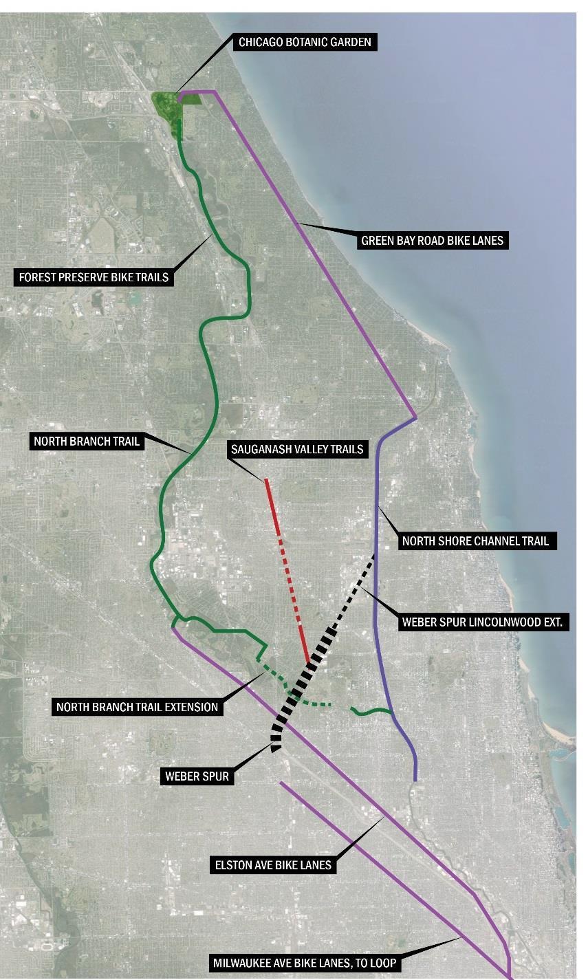
4 Project Context - North Shore Channel Trail The North Shore Channel Trail is a multi-use path that follows the North Shore Channel north, through Chicago, Lincolnwood, Skokie, and Evanston The North Shore Channel Trail extends from the junction of Green Bay Road and McCormick Boulevard in northern Evanston to the junction of Lawrence Avenue and Francisco Avenue in Chicago Approximately 6.7 miles long The Trail is used to connect to the northern suburbs, Skokie Northshore Sculpture Park, numerous parks along the trail, Chicago Botanic Gardens, Erickson Woods, Skokie Lagoons

5 Project Context - Regional

6 Moving Along the Trail North of Devon from Lincoln Wood Devon Ave. Canoe Launch W. Peterson Ave.

7 Moving Along the Trail - Chicago Park Districts Proposed Park 526 Devon Ave. Canoe Launch W. Peterson Ave.


8 Moving Along the Trail - Trail passes by Apartment Building and Ramp to Canoe Launch Devon Ave. Canoe Launch W. Peterson Ave.


9 Moving Along the Trail - Trail ends at Lincoln Ave, Trail users use Lincoln Ave or Sidewalk Devon Ave. Canoe Launch W. Peterson Ave.


10 Moving Along the Trail - Trail users backtrack to pass under Lincoln & Peterson Bridges Devon Ave. Canoe Launch W. Peterson Ave.


11 Moving Along the Trail - Trail then continues south through Legion Park Devon Ave. Canoe Launch W. Peterson Ave.


12 Existing Project Conditions New Bridge Location Devon Ave. Canoe Launch West Side Granville Ave. Currently use high volume Lincoln Ave/US 41 to connect to the North Shore Channel Trail on either W. Peterson side W. of Peterson the Ave. channel Ave. East Side
13 Project Needs and Benefits Needs: To provide a safe crossing; high traffic volumes on Lincoln Ave makes access and crossing difficult for trail users Devon Ave. To complete the final connection on the North Shore Channel Trail Benefits: Provides a safe grade separated crossing; pedestrians and cyclists will no longer need to use high volume US 41 to continue on the trail, improving safety for all users Connects the existing shared-use path on the east and west Canoe side of the North Shore Launch Channel, closing the final gap in the 6.7 mile North Shore Channel Trail The bridge is the final link in the contiguous multi-use trail connecting four municipalities along the North Shore Channel. W. Peterson Ave.
 - concrete deck/path Will connect to a 12 ft. wide multi-use path with 2 ft.")
14 Proposed Project Improvements A single-span prefabricated weathered steel bicycle and pedestrian bridge Bridge Abutments located outside the waterway Span is approximately 180 feet Vertical Clearance above water varies: 9 8 at 50 year high water level 16 ft. wide (inside clear distance) - concrete deck/path Will connect to a 12 ft. wide multi-use path with 2 ft. shoulder on each side

15 Proposed Project Improvements Weathered Steel to compliment outdoor setting Mechanically Stabilized Earth retaining wall to stabilize embankment Asphalt path with concrete bridge deck with required pavement markings Fencing and Lighting along both approaches to the bridge Vegetation removal and landscape improvements

16 Close-up view of Bridge


17 Examples of Pedestrian/Bike Bridges Prefab Bridge being Delivered Prefab Bowstring Truss Bridge Valley Line Trail Bridge N. Rogers Ave North Spaulding Ave La Rosa Reserve Green Bay


18 Examples of Pedestrian/Bike Bridges Prefab Bridge being Delivered
19 Project Schedule Complete Phase I Preliminary Engineering and submit for IDOT and FHWA approval Fall 2016 Complete Final Design and Engineering and submit for IDOT and FHWA approval Early Summer 2017 Bid and Award Construction Fall 2017 Contract Start Construction Winter 2018


20 Thank you Website Facebook facebook.com/cdotnews Lubka Benak, Project Manager, Streetscape and Sustainable Design Program,
TRAFFIC COMMISSION, VILLAGE OF LINCOLNWOOD 6900 N. Lincoln Avenue, Lincolnwood, IL 60712
 TRAFFIC COMMISSION, VILLAGE OF LINCOLNWOOD 6900 N. Lincoln Avenue, Lincolnwood, IL 60712 Meeting Agenda Thursday, May 25, 2017 7:00 p.m. Village Hall Council Chambers 6900 N. Lincoln Ave. Lincolnwood,
Study Overview and Context
 Study Overview and Context North Shore Coordination Plan Study Study Highlights Early 2016 to December 2017 Consultant team assistance Steering Committee review Two rounds of public open house events Project
Texas Department of Transportation Corpus Christi District. Corpus Christi Harbor Bridge
 Texas Department of Transportation Corpus Christi District Corpus Christi Harbor Bridge Presented by Russel W. Lenz, P.E. Corpus Christi District Engineer For 2009 Texas Ports and Waterways Conference
RW Bruhn Bridge and Approaches Project
 RW Bruhn Bridge and Approaches Project The Trans-Canada Highway 1 RW Bruhn Bridge and Approaches Project involves four-laning approximately 1.9 km of Highway 1 in Sicamous, including replacement of the
Grade Crossings in High Speed Rail Corridors
 Grade Crossings in High Speed Rail Corridors 59 th ANNUAL ILLINOIS TRAFFIC ENGINEERING & SAFETY CONFERENCE October 21, 2010 Champaign, IL Michael E. Stead Rail Safety Section Illinois Commerce Commission
Damen Elston Fullerton Reconstruction, Intersection Improvements CDOT Project B-1-501
 Damen Elston Fullerton Reconstruction, Intersection Improvements CDOT Project B-1-501 Bird s Eye View of Existing INTRODUCTION This project is part of the City s Building a New Chicago initiative in conjunction
Atlantic Street Bridge Project Update CTDOT Project Nos & (Phase 2)
") Atlantic Street Bridge Project Update CTDOT Project Nos. 135-301 & 301-163 (Phase 2) Reconstruction of Atlantic Street & Metro-North RR Bridge Replacement Track & Station Infrastructure Improvements City
Atlantic Street Bridge Project Update CTDOT Project Nos. 135-301 & 301-163 (Phase 2) Reconstruction of Atlantic Street & Metro-North RR Bridge Replacement Track & Station Infrastructure Improvements City
Trail Feasibility Study
 VOLUSIA COUNTY MPO CITY OF NEW SMYRNA BEACH FINAL REPORT JUNE 30, 2009 Trail Feasibility Study What s inside? 1 Introduction 2 Project Purpose & Scope 3 Physical Inventory & Assessment of Right-of- Way
Public Information Center August 12, 2010
 Route 52 Causeway Bridge Replacement & Somers Point Circle Elimination Project Somers Point Atlantic County Public Information Center August 12, 2010 Ocean City Cape May County Presentation Overview General
N. Central St. & W. Jackson Ave. Streetscape Projects
 N. Central St. & W. Jackson Ave. Streetscape Projects October 13, 2016 Meeting Overview North Central Street City of Knoxville KUB History & Vision Plan Timing Project Area Overview Schedule Communications
Mason Street Bike/Pedestrian Trail Project
 Construction of the much-anticipated Mason Trail is underway! Mountain Constructors was awarded the contract in September but had to go through a 2- month process to obtain construction clearance permits
Dufferin Jog Elimination Project
 Project Project Status Update November 14 2007 Project History Planning Alternatives Criteria Measured Project Benefits Structural Configurations Considered Structural Design Considerations The Preferred
MPRB: Southwest LRT Community Advisory Committee Issues and Outcomes by Location Current to: 12 November 2010
 MPRB: Southwest LRT Community Advisory Committee Issues and Outcomes by Location Current to: 12 November 2010 This is a compilation of issues and outcomes identified by the CAC. It is a work in progress,
Palm Beach County Traffic Report July 13 through July 20, 2012
 For Immediate Release July 13, 2012 Meredith Cruz, (561) 641-6440 mcruz@corradino.com Palm Beach County Traffic Report July 13 through July 20, 2012 Palm Beach County Palm Beach County traffic will be
Transportation TRANSPORTATION PROJECTS
 Transportation TRANSPORTATION PROJECTS Balls Ford Road Interchange Total Project Cost $142.9M This project includes the construction of a new diverging diamond interchange at Route 234 Bypass (Prince William
STAGE 2 & 3 Pavement reconstruction within viaduct footprint, pavement widening and resurfacing N/S of viaduct footprint, sidewalk
 STAGE 1 Viaduct removal, deck replacement on the River Bridge, and approach of the Chicago River Bridge north to Roscoe) Maintain local access roadways - 1 lane in each direction A signed alternate route
Pattullo Bridge Replacement Project
 Pattullo Bridge Overview This document will: Explain the challenges facing the Pattullo Bridge today Share how we propose moving forward translink.ca PAGE 1 History By Order of the Lieutenant Governor
Blue River Trail Master Plan JSA to Town Hall June 2004
 Blue River Trail Master Plan JSA to Town Hall June 2004 Prepared for: Silverthorne Town Council Silverthorne SPORT Committee Department of Recreation and Culture Silverthorne Public Works Silverthorne
April 4, 2014 Chuck McGinness, FDOT TREASURE COAST TRAFFIC REPORT April 4 through April 11, 2014
 April 4, 2014 Chuck McGinness, 954-777-4090 Chuck.McGinness@dot.state.fl.us FDOT TREASURE COAST TRAFFIC REPORT April 4 through April 11, 2014 TREASURE COAST Construction and maintenance-related lane closures
Introduction. Project Overview
 Washington Blvd./Andora Widening Project Community Open House & Public Scoping Meeting Summary Wednesday, September 21, 2016 6:00 7:30 p.m. Vencil Brown Elementary School, Roseville Introduction On Wednesday,
Longmont to Boulder Regional Trail Jay Road Connection DRAFT FINAL REPORT
 Longmont to Boulder Regional Trail Jay Road Connection DRAFT FINAL REPORT December 2018 Project Summary Boulder County, Colorado, in partnership with the City of Boulder, is evaluating options for multi-use
2013 Regional Water System Improvements Program Public Hearing March 14, 2013
 In support of Illinois Environmental Protection Agency State Revolving Fund Loan Application 2013 Regional Water System Improvements Program Public Hearing March 14, 2013 Village of Oak Lawn Customer Communities:
Auburn Trail / Ontario Pathways Trail Connector Feasibility Study Public Information Meeting Wednesday, August 22, 2012
 Auburn Trail / Ontario Pathways Trail Connector Feasibility Study Public Information Meeting Wednesday, August 22, 2012 Purpose of Feasibility Study Purpose Evaluate the feasibility of constructing a multiuse
Macleod Trail Corridor Study. Welcome. Macleod Trail Corridor Study Open House. Presentation of Proposed Design Concepts
 Macleod Trail Corridor Study Welcome Macleod Trail Corridor Study Open House Presentation of Proposed Design Concepts Study Purpose Develop a corridor plan for Macleod Trail that aligns with The City s:
Chicago St. Louis High-Speed Rail. Enos Park Neighborhood Association May 13, 2014
 Chicago St. Louis High-Speed Rail Enos Park Neighborhood Association May 13, 2014 1 Illinois High-Speed Rail Program 2 Chicago-St. Louis Corridor» IDOT has actively developed the corridor since the mid1980
3. COLTA / HUGA CONNECTIONS - PRELIMINARY
 9 3. COLTA / HUGA CONNECTIONS - PRELIMINARY 3.1 COLTA The Chain of Lakes Trail Association (COLTA) trail, formerly identified as the Chester Spur Line, was completed and opened for use in June 2011. The
Welcome to the Illinois High-Speed Rail Chicago to St. Louis Construction Update Meeting. Today s meeting will provide an overview of the Program,
 Welcome to the Illinois High-Speed Rail Chicago to St. Louis Construction Update Meeting. Today s meeting will provide an overview of the Program, updates on construction to be held in this area, and how
COMMITTEE OF THE WHOLE (WORKING SESSION) APRIL 19, 2011 YORK REGION RAPID TRANSIT HIGHWAY 7 BUS RAPID TRANSIT- VMC STATION WARD 4.
 APRIL 19, 2011 YORK REGION RAPID TRANSIT HIGHWAY 7 BUS RAPID TRANSIT- VMC STATION WARD 4.") COMMITTEE OF THE WHOLE (WORKING SESSION) APRIL 19, 2011 YORK REGION RAPID TRANSIT HIGHWAY 7 BUS RAPID TRANSIT- VMC STATION WARD 4 Recommendation The Commissioner of Engineering and Public Works and the
COMMITTEE OF THE WHOLE (WORKING SESSION) APRIL 19, 2011 YORK REGION RAPID TRANSIT HIGHWAY 7 BUS RAPID TRANSIT- VMC STATION WARD 4 Recommendation The Commissioner of Engineering and Public Works and the
Update on Trinity Trails. Presented by: Richard Zavala, Director Park and Recreation Department February 7, 2017
 Update on Trinity Trails Presented by: Richard Zavala, Director Park and Recreation Department February 7, 2017 Overview Provide review of trail planning and development along the main stem Trinity River
Port Gamble Shoreline Area Conceptual Trail Proposal
 The North Kitsap Trails Association is pleased to be a partner to the Kitsap Forest and Bay Project and assist Kitsap County, Forterra, Olympic Property Group, Great Peninsula Conservancy and the Port
Appendix JK. Noise Barrier Visualizations. I-290 Eisenhower Expressway Cook County, Illinois. Prepared For: Illinois Department of Transportation
 Appendix JK Noise Barrier Visualizations I-290 Eisenhower Expressway Cook County, Illinois Prepared For: Illinois Department of Transportation Prepared By: WSP Parsons Brinckerhoff September August 2016
May 1, 2015 Meredith Cruz, (561) Palm Beach County Traffic Report May 1 through May 8, 2015
 Palm Beach County Traffic Report May 1 through May 8, 2015") May 1, 2015 Meredith Cruz, (561) 641-6440 mcruz@corradino.com Palm Beach County Traffic Report May 1 through May 8, 2015 Palm Beach County Palm Beach County traffic will be affected this week by ongoing
May 1, 2015 Meredith Cruz, (561) 641-6440 mcruz@corradino.com Palm Beach County Traffic Report May 1 through May 8, 2015 Palm Beach County Palm Beach County traffic will be affected this week by ongoing
Projected Advertisement Date
 2013 Planned s CY 2013 and CY 2014 Richmond District Schedule Preliminary Engineering Task Order Contracts SR 288/SR 145 Survey, 288 90349 Chesterfield Ramp and Signal Design 2/27/2013 $ 0.19 I-64 Over
State Project Reconstruction I-84
 State Project 151-273 Reconstruction I-84 Waterbury, Connecticut FROM WASHINGTON STREET TO PIERPONT ROAD I-84 Constructors J.V. Robert Turner Area Engineer Ken Fargnoli District Engineer John Dunham Assistant
Town Hall Meeting. July 28, 2016 Sherwood School of Music 1312 S. Michigan Ave.
 Town Hall Meeting July 28, 2016 Sherwood School of Music 1312 S. Michigan Ave. Stay connected! 5046 S. State St. Chicago, IL. (773) 373-9273 ward03@cityofchicago.org www.dowellforthirdward.com Facebook.com/aldermanpat.dowell
25 th Avenue Grade Separation. September 13, 2017
 25 th Avenue Grade Separation September 13, 2017 Agenda I. Overview II. III. IV. Project Description Project Benefits Project Construction V. Next Steps VI. Questions 2 Overview Project Location 4 E. 25
Regional Wayfinding Sign Strategy Thurston County Trails 2017
 Regional Wayfinding Sign Strategy Thurston County Trails 2017 Partners: Members and partnering organizations of the Thurston Thrives Community Design Action Team City of Lacey, City of Olympia, City of
Georgetown-Lewes Rail/Trail Study. Rail/Trail Study: Cool Spring to Cape Henlopen State Park New Road Extension (House Resolution No.
 Georgetown-Lewes Rail/Trail Study Rail/Trail Study: Cool Spring to Cape Henlopen State Park New Road Extension (House Resolution No. 47) August 22, 2011 Presentation Outline Background Benefits Statewide
25 th Avenue Grade Separation. December 13, 2017
 25 th Avenue Grade Separation December 13, 2017 Agenda I. Overview II. III. IV. Project Description Project Benefits Project Construction V. Next Steps VI. Questions 2 Overview Project Location 4 E. 25
Ohio Department of Transportation Construction Update
 Ohio Department of Transportation Construction Update DISTRICT 5 DAVE RAY, P.E., P.S., DISTRICT DEPUTY DIRECTOR 9600 Jacksontown Road Jacksontown, OH 43030 www.transportation.ohio.gov/dist5 ODOT District
Crystal City Station Improvements. Project Overview. Table 2: North Entrance. Table 1: South Entrance. 20th St. S 18th St. S.
 Table 1: South Entrance Table 2: North Entrance 20th St. S 18th St. S Proposed Second Entrance Crystal Drive Existing Station Location Platform Future 4 th Track Future New Airport Connection (by others)
1.2 Corridor History and Current Characteristics
 SECTION 1 Description and Background of Study Area 1.1 Introduction This preliminary engineering report was prepared for the Alaska Department of Transportation and Public Facilities (ADOT&PF). It is part
Proposed Bicycle Lanes on Yonge Street from Queens Quay to Front Street
 STAFF REPORT ACTION REQUIRED Proposed Bicycle Lanes on Yonge Street from Queens Quay to Front Street Date: March 12, 2007 To: From: Toronto and East York Community Council Director, Transportation Infrastructure
Additional Economic Development Strategy submissions- Klickitat County
 Klickitat County Transportation Improvement Projects 1 White Salmon to Hood River Bridge Final EIS, design, bridge replacement 2 Klickitat County Rural Arterials Reconstruct to all-weather roads Part of
Carlisle Connectivity Projects Communication Plan and Project Status
 Carlisle Connectivity Projects Communication Plan and Project Status Overview Communication Plan Communication Plan Communication Plan Objective The Borough staff will develop and execute timely and effective
ETOBICOKE CREEK NORTH TRAIL PROJECT. May 18, 2017 at Michael Power High School 105 Eringate Drive, Etobicoke ON M9C 3Z7
 ETOBICOKE CREEK NORTH TRAIL PROJECT May 18, 2017 at Michael Power High School 105 Eringate Drive, Etobicoke ON M9C 3Z7 1 Purpose of Open House The purpose of today s open house is to present the design
Citrus Heights Creek Corridor Trail Project Trail Advisory Group Field Trip #2 September 11, :00 11:00 am Trellis Hall, Citrus Heights
 September 11, 2013 9:00 11:00 am Trellis Hall, Citrus Heights Project Overview The City of Citrus Heights is studying the feasibility of establishing a multi use trail system within the City s 26 miles
EXTERNAL COMMUNICATIONS COMMITTEE MEETING APRIL 2015
 EXTERNAL COMMUNICATIONS COMMITTEE MEETING APRIL 2015 35EXPRESS PROJECT OVERVIEW 2 SEGMENT 1 3 SOUTH OF I-635 May Shift northbound mainlane traffic east in the southeast quadrant Miscellaneous frontage
Mohawk Hudson Bike Hike Trail Crossroad Connection Study
 Summary Report - April 21, 2003 Mohawk Hudson Bike Hike Trail Crossroad Connection Study Summary Report Introduction The Capital District Transportation Committee (CDTC), in partnership with Albany County,
SAN RAFAEL City Council January 20, 2015
 SONOMA MARIN AREA RAIL TRANSIT SMART CENTRAL SAN RAFAEL STATUS UPDATE SAN RAFAEL City Council January 20, 2015 CENTRAL SAN RAFAEL SMART SOUTH OF PUERTO SUELLO TUNNEL 1. Active Construction 2. Construction
Culpeper District. Albemarle County Monthly Report December 2011
 Culpeper District Albemarle County Monthly Report Special Issues Construction Significant Accomplishments (as of 11/15/11) Georgetown Road completed on November 8. I-64 Eastbound Shadwell Exit completed
TRAFFIC COMMISSION, VILLAGE OF LINCOLNWOOD 6900 N. Lincoln Avenue, Lincolnwood, IL 60712
 TRAFFIC COMMISSION, VILLAGE OF LINCOLNWOOD 6900 N. Lincoln Avenue, Lincolnwood, IL 60712 Meeting Agenda - Revised Thursday, March 22, 2018 7:00 p.m. Village Hall Council Chambers 6900 N. Lincoln Ave. Lincolnwood,
CREATING CONNECTIONS IN THE CITY OF NIAGARA FALLS
 CREATING CONNECTIONS IN THE CITY OF NIAGARA FALLS LEON STAMBOLICH, DIRECTOR, CORRIDOR INFRASTRUCTURE ERIN MOROZ, DIRECTOR, COMMUNICATIONS AND COMMUNITY RELATIONS NIAGARA FALLS CITY COUNCIL NOVEMBER 28,
THREE MILE PLAN TOWN OF SUPERIOR COLORADO
 THREE MILE PLAN TOWN OF SUPERIOR COLORADO February 23, 2015 INTRODUCTION This document has been prepared by the Town of Superior, Colorado, to address the existing and proposed land uses within an approximate
Welcome to the Cross County Trail Public Input Session!
 Welcome to the Cross County Trail Public Input Session! Please sign in on the table below! What are we doing here? Camden County has proposed a bicycle and pedestrian trail spanning across the entire county.
4.0 Context for the Crossing Project
 4.0 Context for the Crossing Project This section provides background information about key features of the North Douglas Crossing project area, and opportunities and constraints. This information is important
NOTICE OF PREPARATION/NOTICE OF PUBLIC SCOPING MEETING
 Notice Of Preparation/Notice of Public Scoping Meeting for a Draft Environmental Impact Report for the Airport Park Expansion Project CITY OF SANTA MONICA CITY PLANNING DIVISION 685 MAIN STREET, ROOM 22
FEASIBILITY CRITERIA
 This chapter describes the methodology and criteria used to evaluate the feasibility of developing trails throughout the study areas. Land availability, habitat sensitivity, roadway crossings and on-street
Palm Beach County Traffic Report August 24 through August 31, 2012
 For Immediate Release August 24, 2012 Meredith Cruz, (561) 641-6440 mcruz@corradino.com Palm Beach County Traffic Report August 24 through August 31, 2012 Palm Beach County Palm Beach County traffic will
Berkshire Local Transport Body. Pro- forma for Consideration of a Transport Scheme at Programme Entry Stage. Section 1: Headline Description
 Berkshire Local Transport Body Pro- forma for Consideration of a Transport Scheme at Programme Entry Stage Section 1: Headline Description Local Authority Royal Borough of Windsor and Maidenhead Number
Atlantic Street Bridge Project CTDOT Project Nos & (Phase 2)
") Atlantic Street Bridge Project CTDOT Project Nos. 135-301 & 301-163 (Phase 2) Reconstruction of Atlantic Street & Metro North RR Bridge Replacement Track & Station Infrastructure Improvements City of Stamford
Atlantic Street Bridge Project CTDOT Project Nos. 135-301 & 301-163 (Phase 2) Reconstruction of Atlantic Street & Metro North RR Bridge Replacement Track & Station Infrastructure Improvements City of Stamford
Trail # NW Tuesday, June DESIGN. Provide an Review the Provide an. Project Goals: System system. wayfinding
 I. Welcome / Introductions Bethany Creek Trail #2 Segment 3 Neighborhood Meeting #1 Bethany Presbyterian Church 15505 NW Springville Road, Portland, OR 97229 Tuesday, June 26, 2018 @ 6:00PM Meeting Minutes
Engagement Summary Report. Trans-Canada Highway 1 RW Bruhn Bridge and Approaches Project Community Engagement February 1 18, 2018.
 Trans-Canada Highway 1 RW Bruhn Bridge and Approaches Project Community Engagement February 1 18, 2018 Engagement Summary Report April 2018 Prepared by Kirk & Co. Consulting Ltd. Trans-Canada Highway 1
Committee. Presentation Outline
 CW-33-15 11/9/2015 Community and Corporate Services Committee November 10, 2015 1 Presentation Outline Background Vision and Objectives Study Process and Timeline Public and Stakeholder Engagement Organization
1 PROJECT STATUS UPDATE 2 ND CONCESSION FROM BRISTOL ROAD TO DOANE ROAD TOWNS OF EAST GWILLIMBURY AND NEWMARKET
 Report No. 3 of the Regional Council Meeting of March 28, 2013 1 PROJECT STATUS UPDATE 2 ND CONCESSION FROM BRISTOL ROAD TO DOANE ROAD TOWNS OF EAST GWILLIMBURY AND NEWMARKET The recommends: 1. Receipt
LESLIE BARNS & CONNECTION TRACK. Project Update Construction and Traffic Management Consultation
 LESLIE BARNS & CONNECTION TRACK Project Update Construction and Traffic Management Consultation PRESENTATION SUMMARY Part 1 Brief Project Update (New Streetcars & Streetscape Improvements) Part 2 Construction
Memo. Orange City Trail Plan Becky Mendez, AICP Jamie Krzeminski, PE, PTOE Matt Wiesenfeld, PE, AICP. Development of the Existing and Proposed Network
 Memo Date: Friday, December 22, 2017 Project: To: From: Subject: Trail Plan Becky Mendez, AICP Jamie Krzeminski, PE, PTOE Matt Wiesenfeld, PE, AICP Development of the Existing and Proposed Network HDR
HARP AUTHORITY GATEWAY CENTER BOATHOUSE & CHANNEL EXTENSION TO SANTA FE AVENUE. Pueblo City Council Presentation September 17, 2018
 HARP AUTHORITY GATEWAY CENTER BOATHOUSE & CHANNEL EXTENSION TO SANTA FE AVENUE Pueblo City Council Presentation September 17, 2018 PROJECT: 1A HARP Expansion FUNDING 1A Ballot Issue Pueblo County : $3,000,000
2600 COLORADO ENTRY DESIGN
 2600 COLORADO ENTRY DESIGN SANTA MONICA ARB REVIEW COVER 2600 COLORADO AVENUE, SANTA MONICA, CALIFORNIA 11/13/2017 A001 PROJECT DESCRIPTION 2600 COLORADO WILL SERVE AS A NEW HOME FOR ORACLE CORPORATION.
Innerbelt Bridge Contract Group 2 Tremont / Towpath Trail and Gateway January 8, 2013
 Innerbelt Bridge Contract Group 2 Tremont / Towpath Trail and Gateway January 8, 2013 Cleveland Innerbelt Construction Schedule former schedule 2011 Winter Begin Construction Innerbelt CCG1 (WB Bridge)
Parking Amendments - Bay Street, between Harbour Street and Queens Quay West (York Street, Bay Street, and Yonge Street Ramp Removal)
") REPORT FOR ACTION between Harbour Street and Queens Quay West (York Street, Bay Street, and Yonge Street Ramp Removal) Date: October 26, 2017 To: Toronto and East York Community Council From: Acting Director,
REPORT FOR ACTION between Harbour Street and Queens Quay West (York Street, Bay Street, and Yonge Street Ramp Removal) Date: October 26, 2017 To: Toronto and East York Community Council From: Acting Director,
Construction Update. Local Officials Briefing March 2016
 Construction Update Local Officials Briefing March 2016 1 History: Chicago-St. Louis Corridor Since 1980 s IDOT has been looking at this corridor for high-speed service 1992 Designated a HSR Corridor EIS
22-23 Pavement Marking Items. (Pages 7 & 8 removed)
") 22-23 Pavement Marking Items (Pages 7 & 8 removed) SUMMARY OF TRAFFIC CONTROL DEVICES (FOR INFORMATION ONLY) All traffic control devices shall be placed in accordance with the applicable
22-23 Pavement Marking Items (Pages 7 & 8 removed) SUMMARY OF TRAFFIC CONTROL DEVICES (FOR INFORMATION ONLY) All traffic control devices shall be placed in accordance with the applicable
Sears Centre Arena Julie Avis
 September 24, 2009 MMA Event Sears Centre Arena Julie Avis Jesper Jorgensen Account Executive S 4000 Morgan Street, IL 60609 Phone: 773-843-2091 Fax: 773-843-2078 Mobile: 773-255-3255 Email: jesperjorgensen@clearchannel,com
CHICAGO DEPARTMENT OF AVIATION. Current Construction Projects AND THE O HARE MODERNIZATION PROGRAM. May 2, 2014
 CHICAGO DEPARTMENT OF AVIATION AND THE O HARE MODERNIZATION PROGRAM Current Construction Projects May 2, 2014 O HARE INTERNATIONAL AIRPORT CURRENT CONFIGURATION 2 PHASE 1 & COMPLETION PHASE 9L-27R Completed
Engagement Summary Report. Trans-Canada Highway 1 RW Bruhn Bridge Replacement Project. Community Engagement November 15, 2016 to January 15, 2017
 Trans-Canada Highway 1 RW Bruhn Bridge Replacement Project Community Engagement November 15, 2016 to January 15, 2017 Engagement Summary Report February 2017 Prepared by Kirk & Co. Consulting Ltd. Trans-Canada
STITCH TRANSFORMATIVE IDEA 3. SHORELINE STITCH. Re-connect the city to the waterfront and link the east and west Core Circle landscapes
 SHORE STITCH TRANSFORMATIVE IDEA 3. SHORELINE STITCH Re-connect the city to the waterfront and link the east and west Core Circle landscapes 126 LINE PUBLIC WORK 127 TRANSFORMATIVE IDEA 3. SHORELINE STITCH
Metrolinx Projects: Temporary Delegation for Long- Term Road Closures
 PW29.1 REPORT FOR ACTION Metrolinx Projects: Temporary Delegation for Long- Term Road Closures Date: April 24th, 2018 To: Public Works and Infrastructure Committee From: General Manager, Transportation
I-70/I-71 Project Public Meeting Presented By
 I-70/I-71 Project Public Meeting Presented By Ohio Department of Transportation ms consultants, inc. engineers, architects, planners MSI Design June 9, 2010 W e l c o m e Thom Slack Planning Administrator,
TRAFALGAR PARK. 78: p.140 W 99th St FLAT ROCK CREEK PARK. W 103rd St OVERLAND PARK. Quivira Rd. College Blvd. Shared use path. Mountain bike trail
 Lenexa: overview TRAFALGAR PARK 78: p.140 As the Westport Route crosses over Lenexa's boundaries with Olathe and Overland Park several times, approximately 2.75 or 3 miles of the historic route of the
2 Construction Program
 2018 C P 2018 Districtonstruction 2 Construction Program rogram district 2 Governor John Kasich ODOT Director Jerry Wray District Deputy Director Pat McColley, PE, SI 2018 Construction Program Thank you
Hospital Link Project Project Update September 2015
 Hospital Link Project Project Update September 2015 General The project provides a link between Riverside Drive and the Transitway to the Hospital Ring Road. This link is needed to improve transit service
CREATING CONNECTIONS IN THE CITY OF ST. CATHARINES
 CREATING CONNECTIONS IN THE CITY OF ST. CATHARINES LEON STAMBOLICH, DIRECTOR, CORRIDOR INFRASTRUCTURE BRIAN GALLAUGHER, DIRECTOR, PROJECT PLANNING RER ST. CATHARINES CITY COUNCIL NOVEMBER 13, 2017 A REGION
Claremont Project Background and Update Community Meeting September 11, 2017
 Claremont Project Background and Update Community Meeting September 11, 2017 Topics Project Background Claremont Segment Information Project Timeline Upcoming Discussion Items Upcoming Meetings Questions
B10. Agate Beach State Recreation Site
 B10. Agate Beach State Recreation Site Location Within the City of Newport, just south of the Yaquina Head Outstanding Natural Area. The park is located along the west side of Highway 101 at the mouth
Raytown: overview. map. Santa Fe, Oregon, and California National Historic Trails KANSAS CITY KANSAS CITY. 38 Trail alignments: Raytown.
 Raytown: overview Blue Ridge Cut-off map 18: p.42 RICE- TREMOTI HOME Raytown Tfwy KASAS 17: p.41 JUCTIO WITH ROCK ISLAD LIE RIGHT OF WAY 16: p.40 BUS STOP AT E 51ST AD BLUE RIDGE (KASAS ) Sterling Ave
Markham Multi-use Pathway (MUP) (16 th Avenue to Bob Hunter Memorial Park) Development Services Committee. January 27, Schollen & Company Inc.
 (16 th Avenue to Bob Hunter Memorial Park) Development Services Committee. January 27, Schollen & Company Inc.") Markham Multi-use Pathway (MUP) (16 th Avenue to Bob Hunter Memorial Park) January 27, 2015 Development Services Committee Mark Schollen Schollen & Company Inc. Purpose of Presentation Update Council on
Markham Multi-use Pathway (MUP) (16 th Avenue to Bob Hunter Memorial Park) January 27, 2015 Development Services Committee Mark Schollen Schollen & Company Inc. Purpose of Presentation Update Council on
5.7 Local road upgrades
 5.7 Local road upgrades Local roads around the St Peters interchange and the intersection of Campbell Road and Euston Road would be upgraded to ensure safe and efficient connections with the New M5, and
IRONTON-RUSSELL BRIDGE REPLACEMENT
 IRONTON-RUSSELL BRIDGE REPLACEMENT 2012-2016 District 9 Ohio Department of Transportation Ironton-Russell Bridge Replacement Existing Ironton-Russell Bridge Ironton-Russell Bridge Replacement Existing
Committee Report. Community Development Committee For the Metropolitan Council meeting of April 13, Business Item No.
 Committee Report Business Item No. 2016-48 Community Development Committee For the Metropolitan Council meeting of April 13, 2016 Subject: Harriet Island-South St. Paul Regional Trail Master Plan, Saint
Add-A-Lane Contract V. along a Section of I-95 includes 6 Bridges
 Newton Needham Chamber of Commerce Add-A-Lane Contract V along a Section of I-95 includes 6 Bridges Project File No. 603711 July 29, 2014 1 Agenda Project Update Overview Bid and Contract Award Schedule
Boston Redevelopment Authority 2/26/ Chestnut Hill Avenue Boston/Brookline, MA
 Boston Redevelopment Authority 2/26/2014 Cassidy Playground Waterworks Design revisions made since the DPIR submission March 2013 Massing - Reduced project 16,030 SF, for a total project area of 218,520
Chapter 2: Entire US287 Corridor
 Chapter 2: Entire US287 Corridor The US287 Study Area spans four incorporated jurisdictions and two counties. Due to the length and density of infrastructure along the US287 Study Area, corridor-wide maps
KDOT announces approved November bids
 IMMEDIATE RELEASE Nov. 27, 2018 For more information: Kim Stich 785.296.3585 KDOT announces approved November bids The Kansas Department of Transportation announces approved bids for state highway construction
Community Advisory Panel Meeting #
 Community Advisory Panel Meeting # 6 02.13.19.. Agenda Welcome and Introductions Community Conversations City Council Meeting Debrief Review Citywide Tunnel Video (North Portal Only) Churchill Pedestrian
Presentation Overview
 DON NARROWS Historical and Existing Conditions March 29, 2008 Presentation Overview 1. Project Location and Background 2. Historical Context How did the Don Narrows Come to Be? 3. The Today 4. Next Steps
2433 Dufferin Street Zoning By-law Amendment Application - Preliminary Report
 STAFF REPORT ACTION REQUIRED 2433 Dufferin Street Zoning By-law Amendment Application - Preliminary Report Date: July 22, 2014 To: From: Wards: Reference Number: North York Community Council Director,
CITY COUNCIL AGENDA MEMORANDUM
 To: Mayor and City Council From: Charles Ozaki, City and County Manager Prepared By: Kevin Standbridge, Deputy City and County Manager Katie Allen, City and County Engineer David Shinneman, Community Development
SOUTHBOUND YONGE STREET TO EASTBOUND HIGHWAY 401 F L Y -UNDER
 SOUTHBOUND YONGE STREET TO EASTBOUND HIGHWAY 401 F L Y -UNDER Proposal to Eliminate Traffic Gridlock in South North York Centre Area With Southbound Yonge Street to Eastbound Highway 401 Fly-UNDER A much
FHWA Actions on Past Interstate Requests that were approved by the USRN were presented and conditions were lifted. FHWA Approval Date
 SPECIAL COMMITTEE ON US ROUTE NUMBERING MEETING MINUTES FOR OCTOBER 17, 2013 AND REPORT TO SCOH OCTOBER 18, 2013 SHERATON DOWNTOWN DENVER, DENVER, COLORADO ADDENDUM OCTOBER 28, 2013 The meeting of the