January 19, 2018 Project No C Via
|
|
|
- Charlene Oliver
- 5 years ago
- Views:
Transcription

. The weather was cloudy (approximately 65 F).")
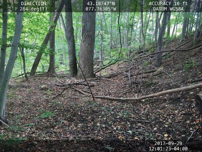
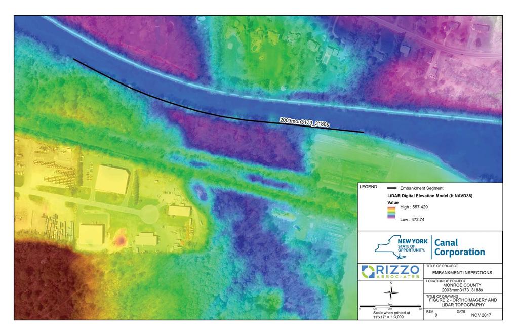
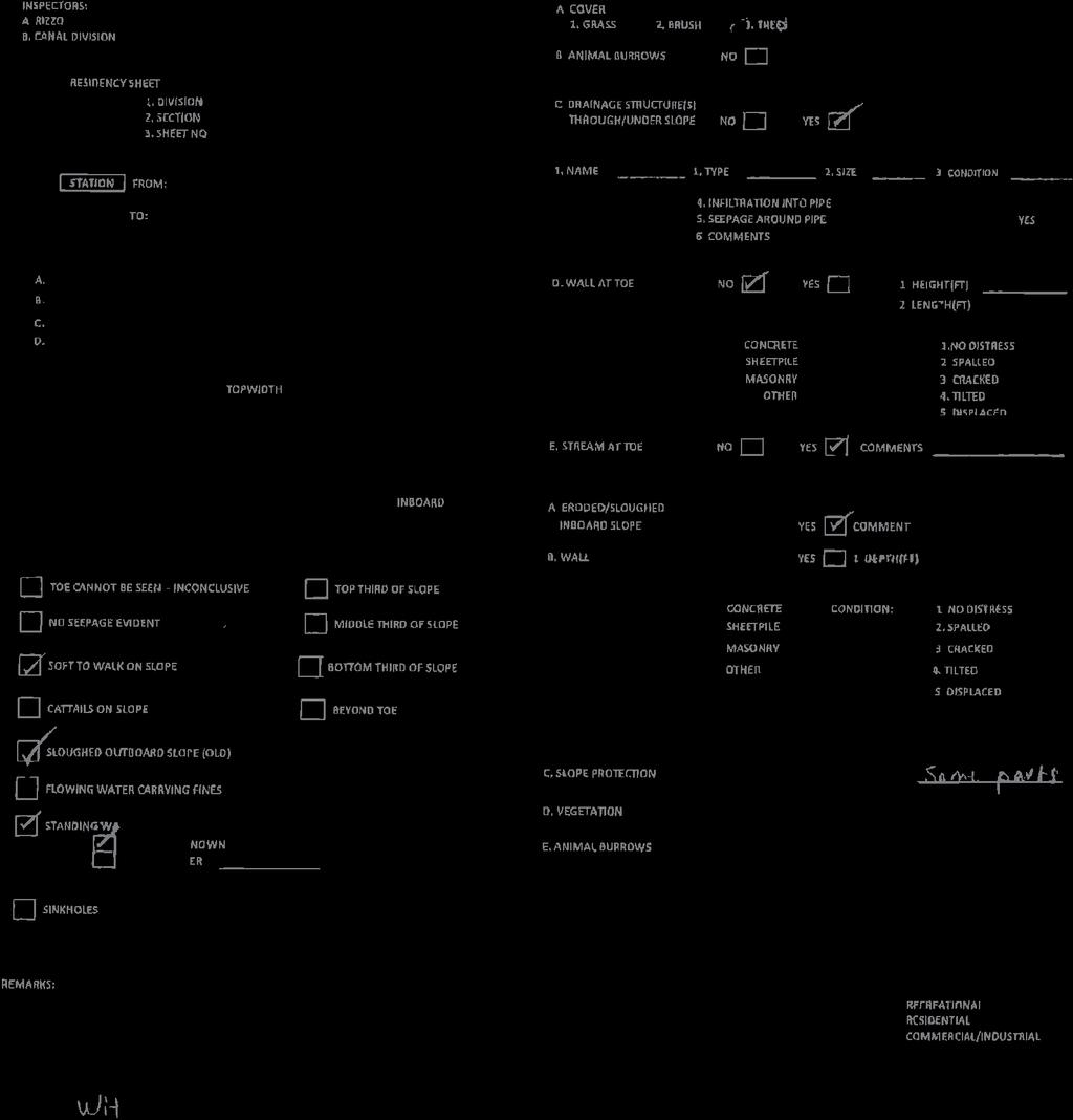
1 Mr. Thomas McDonald, P.E. Professional Engineer II (C/E) Water Management NYS Canal Corporation 30 S Pearl Street Albany, NY January 19, 2018 Project No C Via thomas.mcdonald@canals.ny.gov LETTER REPORT EMBANKMENT INSPECTION REPORT 2003MON3173_3188S NEW YORK STATE CANAL CORPORATION SPENCERPORT, NEW YORK Dear Mr. McDonald: Paul C. Rizzo Engineering New York PLLC (RIZZO) completed an inspection of embankment 2003mon3173_3188s on September 29, 2017 by Mr. A. Hans Hasnay, P.E and Mr. Braulio Vargas. This is the southern section of the embankment and is located near Spencerport, New York ( N, W to N, W). The weather was cloudy (approximately 65 F). The inspection started at 1130 hours and concluded at 1230 hours. This section is located within an area of commercial development. Some areas along the outboard slope are overgrown with bushes and trees. A possible leak located on the outboard slope was observed. An outboard slope failure was noted at one location. This embankment inspection report includes photographs at select locations (Attachment A). Figures are also provided showing the extent of the embankment section and the locations at which the selected photographs were taken (Attachment B; Figure 1), and a LiDAR map showing the elevations at this section of embankment (Attachment B; Figure 2). The embankment inspection sheets containing field notes are also included (Attachment C).
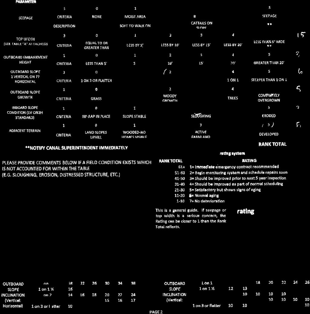
2 Mr. Thomas McDonald, P.E. 2 January 19, 2018 Below is a summary of notable observations: 1. There is an existing seep at the east end of the section that is being monitored. 2. A possible new leak observed near the toe of embankment, located at N, W. Probably caused from fallen tree. 3. Slope is covered with large trees; a lot have fallen with rootball exposed, possible hazard for seepage. 4. High flows in the creek along the toe of the embankment have caused severe undercutting at three locations: N, W N, W (partial slope failure at this location) N, W 5. Localized outboard slope failure was observed at N, W. 6. The crest is narrow and there is a loss of embankment section at the undercut/washout areas. Based on the ranking and rating system developed by New York State Department of Transportation (NYSDOT), the structure has a Condition Rating of 1 (Immediate Emergency Contract Recommended). This section was assigned a New York State Department of Environmental Conservation (NYSDEC) Apparent Class A Hazard Classification due to the lack of development in the likely inundation area. Based on our field observations the assigned hazard classification is appropriate. The continuing undercutting, sloughing and washout cycle that is gradually undermining the embankment is a serious issue and should be address. The hazard class is low but based on its condition and the potential loss of the ability to operate the canal in the event of a failure it is recommended that this section of the embankment be given a Federal Emergency Management Agency (FEMA) Risk Category II - High Urgency rating. RIZZO recommends the following remediation actions be taken as soon as possible:
3 Mr. Thomas McDonald, P.E. 3 January 19, 2018 a) Trained Section staff should perform inspections of this embankment section at least every two months during the navigation season. Prioritize this section for enhanced attention under the Bank Walker Program. b) Remove vegetation from overgrown areas on the embankment and at toe and establish appropriate ground cover vegetation. c) Evaluate potential remediation plans to deal with the on-going undercutting and erosion caused by the stream at toe. d) Implement remediation plans including restoring the embankment at the wash out areas. If you have any questions, do not hesitate to contact me at (914) , Ext. 401 or at hans.hasnay@rizzoassoc.com, or you may also contact Mr. Thomas Edwards at (412) or at tom.edwards@rizzoassoc.com. Respectfully submitted, Paul C. Rizzo Engineering New York, PLLC A. Hans Hasnay, P.E. Vice President New York AHH/BV/TE/zat Attachments A. Hans Hasnay, Vice President, RIZZO Associates, Inc.
4 ATTACHMENT A PHOTOGRAPHS


5 PHOTOGRAPH 1 LARGE TREES ON SLOPE PHOTOGRAPH 2 FALLEN TREES A-1


6 PHOTOGRAPH 3 EXPOSED ROOTBALL FROM FALLEN TREE PHOTOGRAPH 4 POSSIBLE NEW LEAK A-2


7 PHOTOGRAPH 5 CULVERT PHOTOGRAPH 6 CREEK A-3

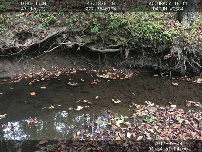
8 PHOTOGRAPH 7 UNDERCUTTING SPOTTED PHOTOGRAPH 8 TOE OF THE EMBANKMENT A-4


9 PHOTOGRAPH 9 FALLEN TREES ON CREEK PHOTOGRAPH 10 SLOPE FAILURE A-5


10 PHOTOGRAPH 11 CREST PHOTOGRAPH 12 INBOARD RIPRAP A-6
11 ATTACHMENT B FIGURES
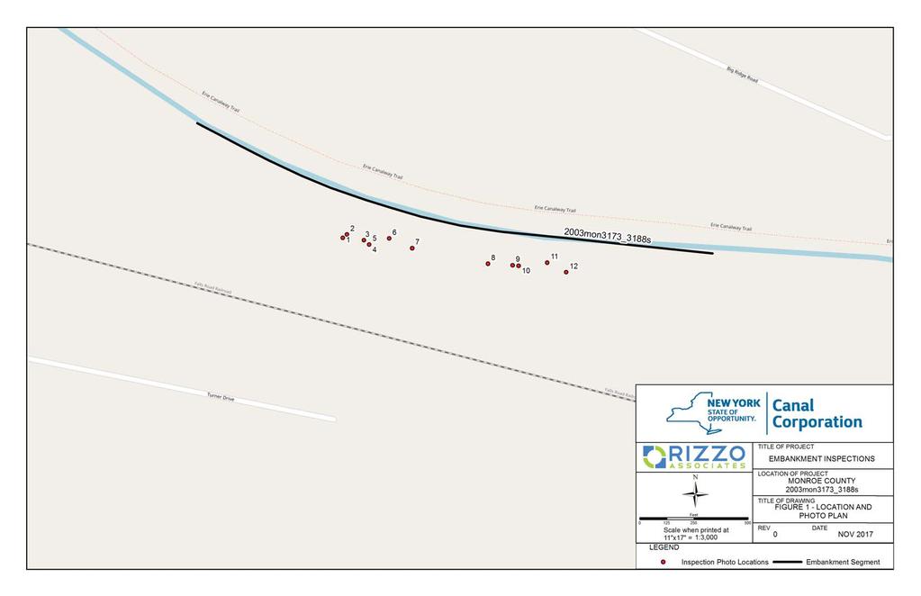
12
13
14 ATTACHMENT C INSPECTION SHEETS

15
16
RE: Complaint Investigation at the Tankersley Food Warehouse
 July 24, 2009 Mr. Thomas Moon, Vice President of Operations Tankersley Food Service 3203 Industrial Park Road Van Buren, AR 72956 RE: Complaint Investigation at the Tankersley Food Warehouse Dear Mr. Moon:
Mount Rainier National Park November 2006 Flood Damage
 On November 6 and 7, 2006, Mount Rainier National Park received 18 inches of rain in 36 hours. This presentation summarizes the extensive flood damage that occurred throughout the park. Updated November
Town of Oakfield Agricultural and Farmland Protection Plan
 SECTION III COMMUNITY OVERVIEW A. Regional Setting / Location The Town of Oakfield is located in the northwestern portion of Genesee County. Located west of New York's Finger Lakes, the Town is uniquely
Lidar Imagery Reveals Maine's Land Surface in Unprecedented Detail
 Maine Geologic Facts and Localities December, 2011 Lidar Imagery Reveals Maine's Land Surface in Unprecedented Detail Text by Woodrow Thompson, Department of Agriculture, Conservation & Forestry 1 Introduction
Peace Project Water Use Plan
 Peace Project Water Use Plan Williston Reservoir Trial Tributaries Implementation Year 5 Reference: GMSWORKS-19 6 Mile 2016 Engineering Inspection Report Study Period: 2016 KERR WOOD LEIDAL Site Inspection
1. PROJECT BACKGROUND. June 25, Alberta Transportation Central Region #401, Street Red Deer, Alberta T4N 6K8
 Alberta Transportation Central Region #401, 4902 51 Street Red Deer, Alberta T4N 6K8 June 25, 2001 Mr. Melvin Mayfield, P.Eng. Construction Services Coordinator Dear Mr. Mayfield: Central Region Landslide
STRATEGIES FOR PROTECTING YOUR PROPERTY
 STRATEGIES FOR PROTECTING YOUR PROPERTY A Homeowner s Guide for Flood, Debris, and Erosion Control after the High Park Fire (Includes tips on how to properly use sandbags) Larimer County Engineering Department
SH73 Route Security Strategic Study Project Summary
 November 2009 SH73 Route Security Strategic Study Project Summary Managing Route Security from Springfield to Aickens STATE HIGHWAY 73 SPRINGFIELD TO AICKENS ROUTE SECURITY STRATEGY CONSULTATION 1. Introduction
Ditch flows slowly to the north
 Ditch flows slowly to the north Photo 1. Wetland DE: Looking west across Wetland DE from upslope. Ponded water, mucky mineral soils, and patches of emergent vegetation observed. Wetland DE appears to be
Non-motorized Trail Plan & Proposal. August 8, 2014
 Town of Star Valley Ranch, Wyoming and the Star Valley Ranch Association in partnership with the USDA Forest Service, Bridger-Teton National Forest, Greys River Ranger District Non-motorized Trail Plan
UNMANNED AIRCRAFT SYSTEMS (UAS) IN UTILITIES
 IN UTILITIES") UNMANNED AIRCRAFT SYSTEMS (UAS) IN UTILITIES Presented by: Dan Carbone Avion Unmanned Why Drones? Why Drones? Cost Effective Entire cost of a UAS program can be recouped in first-year man-hour savings
UNMANNED AIRCRAFT SYSTEMS (UAS) IN UTILITIES Presented by: Dan Carbone Avion Unmanned Why Drones? Why Drones? Cost Effective Entire cost of a UAS program can be recouped in first-year man-hour savings
Principle Causes of Dam Failures. Structural failure. Cracking. Stability failure. BIA Summer Water Resources Training Dam Safety Inspections
 BIA Summer Water Resources Training Dam Safety Inspections Principle Causes of Dam Failures Part 2 Dam Failures July 28, 2012 Presented by Michael Johnson, Ph.D., P.E. Overtopping Structural failure Stability
Appendix C. Past and Current Management of Selected Tidal Wetland Sites
 Appendix C. Past and Current Management of Selected Tidal Wetland Sites Maps and photographs of wetland sites can be found at http://www.elkhornslough.org/tidalwetlandproject. Site 1. Parsons Slough/South
Figure 1 shows the evaluation area around Tailings Basin Cells 2E/1E. Two areas were evaluated for potential wetland impacts including:
 Barr Engineering Company 4700 West 77th Street Minneapolis, MN 55435-4803 Phone: 952-832-2600 Fax: 952-832-2601 www.barr.com An EEO Employer Minneapolis, MN Hibbing, MN Duluth, MN Ann Arbor, MI Jefferson
[Docket No. FAA ; Directorate Identifier 2012-NM-206-AD; Amendment
 This document is scheduled to be published in the Federal Register on 08/06/2013 and available online at http://federalregister.gov/a/2013-18488, and on FDsys.gov [4910-13-P] DEPARTMENT OF TRANSPORTATION
HYDROLOGY OF GLACIAL LAKES, FORT SISSETON AREA
 PROC. S.D. ACAD. SCI., VOL. 77 (1998) 59 HYDROLOGY OF GLACIAL LAKES, FORT SISSETON AREA Perry H. Rahn Department of Geology & Geological Engineering South Dakota School of Mines and Technology Rapid City,
9 December 2016 Maxwell Wolckenhauer NYS DEC State Highway 10, Suite 1 Stamford, NY Conservation.
 Conservation Education Recreation Since 1922 9 December 2016 Maxwell Wolckenhauer NYS DEC 65561 State Highway 10, Suite 1 Stamford, NY 12167 r4.ump@dec.ny.gov RE: Windham-Blackhead Range Wilderness UMP
Request for Proposal National Tropical Botanical Garden Lower Limahuli Preserve Emergency Stream Debris Removal
 Request for Proposal National Tropical Botanical Garden Lower Limahuli Preserve Emergency Stream Debris Removal I. Summary of Work Bids are solicited for the emergency removal of debris deposited in the
ATVANS Trail Assessment for Five Bridge Lakes Wilderness Area Report and Recommendation. December 28, Prepared by.
 ATVANS Trail Assessment for Five Bridge Lakes Wilderness Area Report and Recommendation December 28, 2011 Prepared by Peter Bush Background This report documents the results and recommendations of an all-terrain
Flood History. Floodplain Descriptions
 Flood History The worst flooding in the area took place in 1966, 1969, 1971, 1995 and 1998. The storms in 1966 and 1969 caused considerable damage throughout the area due to flooding, erosion and debris
COON CREEK WATERSHED DISTRICT Request for Board Action
 Item 13: Request to Award Work on Woodcrest Creek Bank Stabilization Project Page 1 of 6 COON CREEK WATERSHED DISTRICT Request for Board Action MEETING DATE: December 8, 2014 AGENDA NUMBER: 13 ITEM: Request
RE: Draft AC , titled Determining the Classification of a Change to Type Design
 Aeronautical Repair Station Association 121 North Henry Street Alexandria, VA 22314-2903 T: 703 739 9543 F: 703 739 9488 arsa@arsa.org www.arsa.org Sent Via: E-mail: 9AWAAVSDraftAC2193@faa.gov Sarbhpreet
Sakhalin-2 Phase 2 Lenders Monitoring Visit Report Annex D: Individual RoW Descriptions
 Annex D: Individual RoW Descriptions Annex D: Individual RoW Descriptions List of RoW Locations Visited KP River / Location Team Date Visited 12-14 Fault Crossing 1 and adjacent RoW Northern 31 August
I. COMMUNICATIONS II. RESOLUTIONS, MOTIONS AND NOTICES
 AGENDA Aviation Committee May 23, 2016 7:00 PM I. COMMUNICATIONS II. RESOLUTIONS, MOTIONS AND NOTICES 1. Resolution authorizing agreement with McFarland Johnson on behalf of the Elmira Corning Regional
Photographic Log Client: Project Number: Site Location: Site Name: Photograph ID: Date: Location: Direction: Comments: Photograph ID:
 Photograph ID: 1 west View of one of the monitoring well and the large parking lot on the south side of Center Street. Photograph ID: 2 Monitoring well located in the middle of the parking lot located
SH6 Route Security Strategic Study Project Summary
 Ocber 2009 SH6 Route Security Strategic Study Project Summary Managing Route Security from Buller Gorge Haast Pass STATE HIGHWAY 6 BULLER GORGE TO HAAST PASS ROUTE SECURITY STRATEGY CONSULTATION 1. Introduction
KP Lasnaya 1 River
 KP 370.2 Lasnaya 1 River The Lasnaya 1 River crossing is protected by Reno mattings and a gabion wall on the north bank (Photo 1). The south bank consists of natural river gravel deposits on top of Reno
A GIS Assessment of Erosion Vulnerability for Unofficial Trails in the Columbia River Gorge
 A GIS Assessment of Erosion Vulnerability for Unofficial Trails in the Columbia River Gorge Sachi Arakawa Geog 593 Digital Terrain Analysis Fall 2017 Abstract The city of North Bonneville, located along
Finn Creek Park. Management Direction Statement Amendment
 Finn Creek Park Management Direction Statement Amendment November 2013 Management Direction Statement Amendment Approved by: Jeff Leahy Regional Director, Thompson Cariboo BC Parks November 12, 2013 Date
Lake Dunstan Trail Project - Geotechnical Review
 11 July 2018 Oli Monthule-Mcintosh Planning Officer Central Otago District Council 1 Dunorling Street PO Box 122 Alexandra WSP Opus Alexandra Office Tarbert Buildings, 69 Tarbert Street PO Box 273, Alexandra
Header i
 Header i 048285014.10 Header Sub Title Body Text here. Body text here. Body text here. Section 1... 1 Executive Summary... 1 Opportunities and Constraints... 3 Overall Opportunities and Constraints Map
North Cruise Berth Projects PortMiami
 North Cruise Berth Projects PortMiami AAPA 2017 Facilities Engineering Seminar Oct 24 26, 2017 Carlos J. Arboleda, PE Vice President Project Director Intermodal Ports 1 PortMiami The Cruise Capital of
Hydro-Electric Schemes Compliance Report June June 2013
 File Reference: 4.00212 Significance of Decision: Receives Only - No Decisions Report To: Operations, Monitoring and Regulation Committee Meeting Date: 20 June 2013 Report From: Nick Zaman, Pollution Prevention
IBAC Technical Report Summary. Caribbean (CAR) and South America (SAM) PIRG. 1st GREPECAS Air Safety Board Meeting. Summary
 and South America (SAM) PIRG. 1st GREPECAS Air Safety Board Meeting. Summary") IBAC Technical Report Summary Subject: Meeting: IBAC File: Reported by: Caribbean (CAR) and South America (SAM) PIRG 1st GREPECAS Air Safety Board Meeting PIRGs Summary The main objectives of the 1st GREPECAS
IBAC Technical Report Summary Subject: Meeting: IBAC File: Reported by: Caribbean (CAR) and South America (SAM) PIRG 1st GREPECAS Air Safety Board Meeting PIRGs Summary The main objectives of the 1st GREPECAS
Josh Clague, Natural Resources Planner NYS DEC 625 Broadway, 5th Floor Albany, NY Via
 16 June 2017 Conservation Education Recreation Since 1922 Member Services 814 Goggins Rd. Lake George, NY 12845-4117 Phone: (518) 668-4447 Fax: (518) 668-3746 e-mail: adkinfo@adk.org website: www.adk.org
Skyline Drive Hogback Canon City
 Skyline Drive Hogback Canon City Direction to trailhead: From US 50, turn north onto 15th Street. At the traffic circle, continue north on 15th Street until it dead ends at Washington Street (about 1.5
Beaver Creek Provincial Park. Management Plan
 Beaver Creek Provincial Park Management Plan 2 Beaver Creek Provincial Park Table of Contents 1. Introduction... 3 2. Park History... 3 3. Park Attributes... 4 3.1 Natural... 4 3.2 Recreational... 4 4.
Design Considerations For Accessible Parks & Trails
 Design Considerations For Accessible Parks & Trails Measuring Up: Campbell River 2008 Dave Calver Consulting City of Campbell River Legacies Now: Measuring Up Design Guidelines Design Considerations for
The Galveston Seawall
 Coastal and Ocean Engineering ENGI.8751 Undergraduate Student Forum Faculty of Engineering and Applied Science, Memorial University, St. John s, NL, Canada. March, 2013 The Galveston Seawall Mark Harvey
City of Berkeley, CA Streetlight Condition Assessment
 City of Berkeley, CA Streetlight Condition Assessment Project Background The City of Berkeley contracted with Tanko Lighting to evaluate the condition of the City s metal streetlights and develop a plan
Project A: Revetment Scale: 1 = 10. 3/7 Revision: Benchmarks. Eroding Parking Area. View from Above. Locklies Creek. Ebb.
 Project A: Revetment Scale: 1 = 10 View from Above Floating Dock 3/7 Revision: Benchmarks 34 Locklies Creek Ebb Flood E. 18x8 Floating Dock Channelward of Vegetation 30 Class A1A Rip Rap MLW MHW 57 1 4
Crew Chief: Start Date: Completion Date: T & A Code:
 Completed Work Data Work order # Crew Chief: Start Date: Completion Date: T & A Code: Work Complete Comments: Personnel Service: Equipment: Item ID# Hours/Miles Rental Cost Supplies & Materials: Item Invoice#
Trail Assessment Report
 Trail Assessment Report Trail Options for the Bear Creek Canyon located in Pikes Peak Ranger District, Pike National Forest and on Colorado Springs Utility Lands Due to the presence of a unique species
 A Unique Treasure, The Restoration of the 1844 Nine Mile Creek Aqueduct in Camillus, New York David W. Beebe, DDS., President, Camillus Canal Society & Camillus Erie Canal Park, Camillus, NY, USA dwbeebe@verizon.net
Leura Cascades to Gordon Falls Reserve
 Leura Cascades to Gordon Falls Reserve 1 hr 15 mins 1.8 km One way Moderate track 200m From Leura Park to Gordon Falls Park, this diverse walk offers fantastic views of the Jamison Valley, as well as two
ROAD AND TRAIL PROJECT APPROVAL
 ROAD AND TRAIL PROJECT APPROVAL www.marincountyparks.org Marin County Parks, 3501 Civic Center Dr, Suite 260, San Rafael, CA 94903 DATE: July 12, 2017 PRESERVE: Gary Giacomini Open Space Preserve PROJECT:
EAST DON TRAIL ENVIRONMENTAL ASSESSMENT. Community Liaison Committee Meeting #3 July 15, :30 to 8:30 pm Flemingdon Park Library
 EAST DON TRAIL ENVIRONMENTAL ASSESSMENT Community Liaison Committee Meeting #3 July 15, 2013 6:30 to 8:30 pm Flemingdon Park Library Agenda 1. Welcome 2. Housekeeping and Updates a) Housekeeping b) CLC
Discontiguous Features Southern Adirondack Feeder Reservoirs
 Section number 7 Page 191 Mile 17.32 Buoy R134 marking head of Cayuga-Seneca Canal at outlet of Seneca Lake limit of historic district boundary Discontiguous Features Southern Adirondack Feeder Reservoirs
Insert Chapter/Page No.
 HARTZELL PROPELLER INC. One Propeller Place Piqua, Ohio 45356-2634 U.S.A. Telephone: 937.778.4200 Fax: 937.778.4215 MANUAL REVISION TRANSMITTAL MANUAL (61-13-70) Composite Propeller Blade Field Maintenance
RIO VISTA MUNICIPAL AIRPORT
 DRAINAGE TECHNICAL MEMORANDUM RIO VISTA MUNICIPAL AIRPORT RIO VISTA, CALIFORNIA Prepared for: City of Rio Vista 1 Main Street Rio Vista, CA 94571 (707) 374-5337 Prepared by: August 2012 Copyright 2012
Greetings IFRR Members!
 Greetings IFRR Members! We are writing to update you on IFRR activities and accomplishments at the recently concluded RI Convention in Atlanta. A great time was had by all in attendance and we want to
1 PLANNING BOARD COUNTY OF ALBANY
 1 PLANNING BOARD COUNTY OF ALBANY 1 2 TOWN OF COLONIE 3 ***************************************************** CORE MATERIALS 4 113 KARNER ROAD SKETCH PLAN 5 *****************************************************
Logo Department Name Agency Organization Organization Address Information 5700 North Sabino Canyon Road
 Logo Department Name Agency Organization Organization Address Information United States Forest Coronado National Forest 5700 North Sabino Canyon Road Department of Service Santa Catalina Ranger District
BACKGROUND DECISION. Decision Memo Page 1 of 6
 DECISION MEMO DEVIL S ELBOW BY-PASS, BOUNDARY TRAIL NO.1 U.S. FOREST SERVICE T9N, R7E, SECTION 9 RANGE 5E COWLITZ COUNTY WA MOUNT ST. HELENS NATIONAL VOLCANIC MONUMENT, GIFFORD PINCHOT NATIONAL FOREST
Mr. Michael Malone CPS Energy 145 Navarro Street San Antonio, Texas Project No
 January 15, 2016 Mr. Michael Malone 145 Navarro Street San Antonio, Texas 78205 Project No. 0328985 Environmental Resources Management CityCentre Four 840 West Sam Houston Pkwy N. Suite 600 Houston, Texas
Photopoint Monitoring in the Adirondack Alpine Zone
 Photopoint Monitoring in the Adirondack Alpine Zone Julia Goren (PI) and Seth Jones Adirondack High Peaks Summit Steward Program Adirondack Mountain Club summit@adk.org PO Box 867, Lake Placid, NY 12946
THE CESSNA AIRCRAFT COMPANY
 Page 1 2010-20-10 THE CESSNA AIRCRAFT COMPANY Amendment 39-16444 Docket No. FAA-2010-0380; Directorate Identifier 2009-NM-009-AD PREAMBLE Effective Date (a) This AD becomes effective November 1, 2010.
Porter Fk. #1. All unauthorized items removed as per FS & Rec Res guidelines. Footbridge may be needed for wheel chair access and for safety
 APPENDIX D Lot Specific Permit Compliance & Forest Plan (FP) Requirements Porter Fork Recreation Residence Tract (Items noted were documented in compliance letter, 8/12/2005, sent to all Rec. Residence
Kit Carson-Challenger Ridge Trail Project
 Kit Carson-Challenger Ridge Trail Project Project Accomplishments Report-USFS December 15, 2015 Photo courtesy of Justin Peterson 815 South 25 th Street, Suite 101 Colorado Springs, CO 80904 Dedicated
Thanks to the efforts of so many people and their support including that of international society, reconstruction is moving steadily ahead.
 Minister Yoshino s Keynote Speech at the Luncheon Plenary of the U.S.-Japan Council Annual Conference Reconstruction from the Great East Japan Earthquake (November 13, 2017, Washington DC) Ladies and gentlemen,
fll,' The University of Georgia O tfo:c o f rh.: Vu:.: Pre,id.:nt for Research
 November 30, 2015 fll,' - - - ----- I M.$------- The University of Georgia ------------------9 O tfo:c o f rh.: Vu:.: Pre,id.:nt for Research U.S. Department of Transportation Docket Management System
THRESHOLD GUIDELINES FOR AVALANCHE SAFETY MEASURES
 BRITISH COLUMBIA MINISTRY OF TRANSPORTATION & INFRASTRUCTURE AVALANCHE & WEATHER PROGRAMS THRESHOLD GUIDELINES FOR AVALANCHE SAFETY MEASURES British Columbia Ministry of Transportation & Infrastructure
At the time, the portion of the line through Eagle County remains wholly under the ownership of Union Pacific Railroad (UP).
.") Chapter 5 The Railroad Corridor as a Trail Corridor The intent of this chapter is to identify how the rail corridor, if available for lease or purchase in all or part, could be incorporated into the core
Chapter 5 The Railroad Corridor as a Trail Corridor The intent of this chapter is to identify how the rail corridor, if available for lease or purchase in all or part, could be incorporated into the core
M.J. Milne & Associates Ltd.
 M.J. Milne & Associates Ltd. March, 29 Tolko Industries Ltd. 6 Yellowhead Highway RR#, Site, C Kamloops, BC V2C K Attention: Mr. Michael Bragg, R.P.F. Dear Sir: Re: Risk Rating Evaluation Non-status Roads
GOOSENECK SWAMP INFORMATION DAY - Saturday 14 th December 2013
 GOOSENECK SWAMP INFORMATION DAY - Saturday 14 th December 2013 Progress of a restoration trial at Gooseneck Swamp - Grampians National Park, Victoria Gooseneck Swamp is situated at the far south-eastern
STAFF REPORT TO COUNCIL
 i CITYOF PRINCE GEORGE STAFF REPORT TO COUNCIL 1100 Patricia Blvd. I Prince George, BC, Canada V2L 3V9 I www.pri ncegeorge.ca DATE: January 24, 2017 TO: NAME AND TITLE: SUBJECT: MAYOR AND COUNCIL Dave
Peter Axelson. Beneficial Designs, Inc. Minden, NV
 Peter Axelson Beneficial Designs, Inc. Minden, NV Arroya Sit Ski Mono Ski Dynamic Seating Spring Assist Cross Country Ski Hand Bike Adaptive Canoe Seating Available from Chosen Valley Canoe Accessories
National Park Service Wilderness Action Plan
 National Park Service U.S. Department of the Interior National Park Service Wilderness Action Plan National Wilderness Steering Committee National Park Service "The mountains can be reached in all seasons.
MINUTES. Additional Stakeholders including CU, CDOT, Town of Erie, and Weld County have been contacted and invited to the recurring progress meetings.
 PROGRESS MEETING BOULDER CREEK MASTER PLAN UDFCD, BOULDER COUNTY, CITIES OF BOULDER & LONGMONT JANUARY 13, 2015 AT 1:00 PM MINUTES 1) ATTENDEES Craig Jacobson, ICON Engineering, Inc. Brian LeDoux, ICON
APPENDIX D: SUSTAINABLE TRAIL DESIGN. APPENDICES Town of Chili Parks and Recreation Master Plan Update
 APPENDIX D: SUSTAINABLE TRAIL DESIGN APPENDICES Town of Chili Parks and Recreation Master Plan Update Sustainable Trail Construction Sustainable trails are defined by the US Forest Service as trails having
[Docket No CE-24-AD; Amendment ; AD ] Airworthiness Directives; Cessna Aircraft Company Model 172RG Airplanes
![[Docket No CE-24-AD; Amendment ; AD ] Airworthiness Directives; Cessna Aircraft Company Model 172RG Airplanes](/thumbs/95/124400569.jpg "[Docket No CE-24-AD; Amendment ; AD ] Airworthiness Directives; Cessna Aircraft Company Model 172RG Airplanes") [4910-13-U] DEPARTMENT OF TRANSPORTATION Federal Aviation Administration 14 CFR Part 39 [66 FR 16846 3/28/2001] [Docket No. 2000-CE-24-AD; Amendment 39-12153; AD 2001-06-06] RIN 2120-AA64 Airworthiness
[4910-13-U] DEPARTMENT OF TRANSPORTATION Federal Aviation Administration 14 CFR Part 39 [66 FR 16846 3/28/2001] [Docket No. 2000-CE-24-AD; Amendment 39-12153; AD 2001-06-06] RIN 2120-AA64 Airworthiness
Cofferdam Performance Hurricanes Harvey & Irma
 Cofferdam Performance Hurricanes Harvey & Irma - 2017 Greg Hammer Senior Geotechnical Engineer CELRH-DSPC-GS DSMMCX Third Workshop on Case Histories in Dam Safety Risk-Informed Decision Making 2018 USSD
Crew Chief: Start Date: Completion Date: T & A Code:
 Completed Work Data Work order # Crew Chief: Start Date: Completion Date: T & A Code: Work Complete Comments: Personnel Service: Equipment: Item ID# Hours/Miles Rental Cost Supplies & Materials: Item Invoice#
OPG, Nuclear 2
 B iodiversity Assessment Building a Biodiversity Management Plan November 24, 2011 OPG, Nuclear 2 Biodiversity Assessment What habitat, or your site? potential habitat, is available on What species of
December 21, Presentation of alternate trail routings, including a new location, and
 December 21, 2009 Salim Adler, Park Planner Agency Building 1, 17th Floor Empire State Plaza Albany, NY 12238 Re: Additional Comments and Recommendations Allegany State Park Master Planning Process Dear
Participant Presentations (Topics of Interest to the Meeting) GASP SAFETY PERFORMANCE INDICATORS. (Presented by the Secretariat) EXECUTIVE SUMMARY
 GASP SAFETY PERFORMANCE INDICATORS. (Presented by the Secretariat) EXECUTIVE SUMMARY") PA RAST/31 WP/03 19/02/18 Thirty First Pan America Regional Aviation Safety Team Meeting (PA RAST/31) of the Regional Aviation Safety Group Pan America (RASG PA) South Florida, United States, 20 to 22
PA RAST/31 WP/03 19/02/18 Thirty First Pan America Regional Aviation Safety Team Meeting (PA RAST/31) of the Regional Aviation Safety Group Pan America (RASG PA) South Florida, United States, 20 to 22
Abbotts Falls Walking Track
 Abbotts Falls Walking Track 3 hrs 7.3 km Circuit Hard track 329m This circuit takes you through both dry and moist forest, using a combination of walking trails and wider tracks. The side trip to the dammed
ALBANY-HUDSON ELECTRIC TRAIL FEASIBILITY STUDY. Final Report OCTOBER 2011
 ALBANY-HUDSON ELECTRIC TRAIL FEASIBILITY STUDY Final Report OCTOBER 2011 ALBANY-HUDSON ELECTRIC TRAIL FEASIBILITY STUDY Prepared for: Town of East Greenbush 225 Columbia Turnpike Rensselaer, New York 12144
Confirmation of Minutes of the General Meeting held on the 8 th September, 2011.
 HERBERT RIVER IMPROVEMENT TRUST GENERAL MEETING MINUTES THURSDAY 113 TH OCTOBER,, 201111 AT 9..00 A..M.. A. ATTENDANCE Present were Mr. W.H. Pickering (Chairperson), Cr. G.P. Gianotti (Member), Cr. P.D.
THE LEVEES OF DALLAS COUNTY
 THE LEVEES OF DALLAS COUNTY Jessica Baker, EIT, CFM Walter Skipwith, P.E. Steve Parker, P.E., CFM TFMA 2008 Spring Conference League City, TX May 1, 2008 Introduction Map Modernization Program Certification
Snowmobiling's Endless Winter:
 August 2002 prepared for Swan View Coalition 3165 Foothill Road Kalispell, MT 59901 www.swanview.org Snowmobiling's Endless Winter: Facilitating Physical Access Also Extends The Snowmobile Season, Resulting
March 2, The Honorable Mayor Williams D. Sessoms, Jr. Members of City Council. Subject: Coastal CIP Presentation to City Council - March 6, 2018
 OFFICE OF THE CITY MANAGER (757) 385-4242 (757) 427-5626 FAX MUNICIPAL CENTER BUILDING 1, ROOM 234 2401 COURTHOUSE DRIVE VIRGINIA BEACH, VA 23456-9001 March 2, 2018 The Honorable Mayor Williams D. Sessoms,
DEPARTMENT OF TRANSPORTATION
 DEPARTMENT OF TRANSPORTATION Federal Aviation Administration 14 CFR Part 39 [70 FR 48857 No. 161; 08/22/05][SN] Tiger Aircraft LLC AD 95-19-15 R1 Amendment 39-14222 Effective Oct. 3, 2005 Revises AD 95-19-15
Survey of Rodman Reservoir and middle-ocklawaha River springs during spring 2008 draw-down conditions: FWC and FWS
 Survey of Rodman Reservoir and middle-ocklawaha River springs during spring 2008 draw-down conditions: FWC and FWS Date of Survey: February 26, 2008 Survey conducted by: Dawn Jennings, USFWS Nicole Adimey,
Attachment G STREAM IMPACTS. Ridge Road Extension Alternatives Analysis
 Attachment G STREAM IMPACTS for: Ridge Road Extension Alternatives Analysis PREPARED FOR: Pasco County Engineering Services Department PREPARED BY: NV5, INC. 6989 E. FOWLER AVENUE TAMPA, FLORIDA 33617
V.D. Taxiing. References: FAA-H ; POH/AFM
 References: FAA-H-8083-3; POH/AFM Objectives Key Elements Elements Schedule Equipment IP s Actions SP s Actions Completion Standards The student should develop knowledge of the elements related to taxiing
Duncan Hastie, P.E. Dewberry
 FEMA s Riverine High Water Marks for Atlanta s September 2009 Flood Event Duncan Hastie, P.E. Dewberry Background High Water Mark Recovery Performed Through FEMA s Hazard Mitigation Technical Assistance
ICAO regional technical cooperation tools for the implementation of air navigation and safety improvements
 RAAC/13-WP/11 10/11/13 International Civil Aviation Organization South American Regional Office Thirteenth Meeting of Civil Aviation Authorities of the South American Region (RAAC/13) (Bogota, Colombia,
FIELD UNIT(S): Methow Valley, Entiat, and Tonasket Ranger Districts
: Methow Valley, Entiat, and Tonasket Ranger Districts") Interagency Special Status Species Program Odonate Survey of Bogs, Fens, and Shallow Ponds Okanogan-Wenatchee National Forest John Rohrer December 2014 SPECIES LIST AND RANKS: ISSSP Global WA State Rank
Interagency Special Status Species Program Odonate Survey of Bogs, Fens, and Shallow Ponds Okanogan-Wenatchee National Forest John Rohrer December 2014 SPECIES LIST AND RANKS: ISSSP Global WA State Rank
United States Department of the Interior National Park Service. Boundary Expansion Listed in National Register January 11, 2017
 NPS Form 10900-a (Rev. 8/2002) OMB No. 10240018 United States Department of the Interior National Park Service Boundary Expansion Listed in National Register January 11, 2017 National Register of Historic
One East First Street Reno, NV
 AECOM City Hall Tower, 16th Floor One East First Street Reno, NV 89501 www.aecom.com 775.337.9565 tel 916.414.5850 fax Mr. David Whalen, P.E. City of Fernley Public Works 595 Silverlace Blvd. Fernley,
Waukegan & Calumet Rivers. All Hands Meeting
 Waukegan & Calumet Rivers 516(e) Update All Hands Meeting David F. Bucaro, P.E. Chief, Economic Formulation & Analysis Section, Planning Branch May 18 th, 2011 Kensington Court Ann Arbor, MI 1 2 Waukegan
Precautionary Search and Landing
 Royal Newcastle Aero Club Flight Training Briefing Notes Supplement Summary Only Please Note The following information is for Royal Newcastle Aero Club student pilots and members only. If you are not a
GOLDEN EARS PROVINCIAL PARK
 GOLDEN EARS PROVINCIAL PARK Trail Information as of October 10 th 2015 Do not underestimate the mountainous wilderness of Golden Ears Provincial Park. The combination of rugged terrain and rapidly changing
TRANSMITTAL. Please contact me with any questions. 7 Spruce Road, Freeport, ME T: (207)
") BAKER DESIGN CONSULTANTS Civil, Marine and Structural Engineering To: Alex Jaegerman FAICP Director of Planning & Development Town of Yarmouth 200 Main Street PO Box 907 Yarmouth, ME 04096 From: Barney
BAKER DESIGN CONSULTANTS Civil, Marine and Structural Engineering To: Alex Jaegerman FAICP Director of Planning & Development Town of Yarmouth 200 Main Street PO Box 907 Yarmouth, ME 04096 From: Barney
MEETING MINUTES BOARD OF PARK COMMISSIONERS WEDNESDAY, May 4, 2011
 MEETING MINUTES BOARD OF PARK COMMISSIONERS WEDNESDAY, May 4, 2011 1. Roll Call 2. Approval of the March 2, 2011 Minutes 3. Overview of Iverson Park Restoration Project (Christopher Badtke, Iverson Park
~ s: Memorandum
 Memorandum CITY OF DALLAS DATe November 13, 2015 ro sva..rc~ Members of the Economic Development Committee: Rickey D. Callahan (Chair), Casey Thomas, II (Vice Chair), Lee M. Kleinman, Adam Medrano, Carolyn
March 4, Mr. H. Dale Hemmerdinger Chairman Metropolitan Transportation Authority 347 Madison Avenue New York, NY Re: Report 2007-F-31
 THOMAS P. DiNAPOLI STATE COMPTROLLER 110 STATE STREET ALBANY, NEW YORK 12236 STATE OF NEW YORK OFFICE OF THE STATE COMPTROLLER March 4, 2008 Mr. H. Dale Hemmerdinger Chairman Metropolitan Transportation
Triangle Land Conservancy Conservation Area Monitoring Report Carolina North
 Triangle Land Conservancy Conservation Area Monitoring Report Carolina North Property Name: Bolin Creek East Conservation Area Date of visit: March 16, 2017 County: Orange Property Type: Restrictive Covenants
Minutes of the Stratford Regular Board meeting held on Thursday, June 11, 2015 at the municipal building located at 120 Piseco Rd.
 State of New York County of Fulton Town of Stratford Minutes of the Stratford Regular Board meeting held on Thursday, June 11, 2015 at the municipal building located at 120 Piseco Rd. Present: Robert Johnson