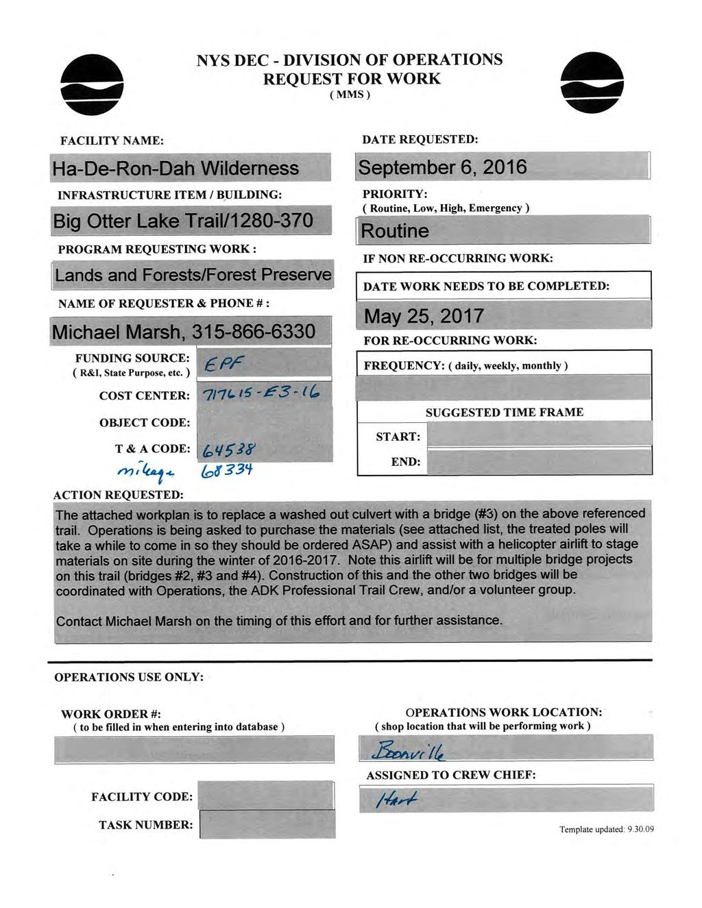
Crew Chief: Start Date: Completion Date: T & A Code:
|
|
|
- Cecil Heath
- 5 years ago
- Views:
Transcription
1
2
3
4 Completed Work Data Work order # Crew Chief: Start Date: Completion Date: T & A Code: Work Complete Comments: Personnel Service: Equipment: Item ID# Hours/Miles Rental Cost Supplies & Materials: Item Invoice# Quantity Unit Cost per Unit Total Cost Contract# Labor Cost: Equip Cost: Material Cost:
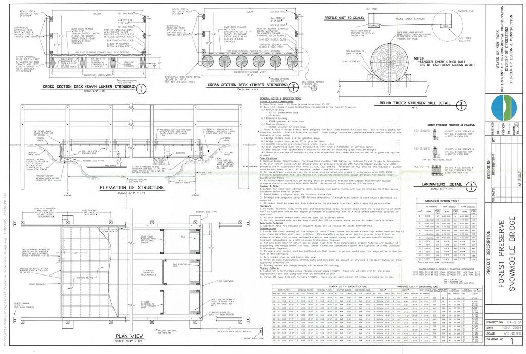
5 Big Otter Lake Trail Rehabilitation 2016: Bridge 3 Current Conditions The Big Otter Lake Trail located within the Ha-De-Ron-Dah Wilderness is a hiking and horseback riding trail in the non-winter months and a cross country skiing trail during the winter. This former road leads from a trailhead in Thendara to the vicinity of its namesake, Big Otter Lake. When this area was designated as Wilderness, the road was closed, gated and maintained as a trail. However, no further measures were taken to put the road to bed. Numerous culverts remained along its entire length, many of which are too small to handle large storm events and some of which have washed out. Following a few heavy rain events in 2015, the eastern end of this trail has deteriorated with numerous washouts. Note that this workplan has been revised from its original form to reflect a shorter (30ft.) bridge design, the treatment of the culvert and the staging of materials via helicopter under CP-17. Proposed Actions This project is the Third in a series of four all aimed at repairing the damage on this trail. It is expected to begin in the summer of 2017 by a combined effort from the Adirondack Mountain Club s Professional Trail Crew and a volunteer group such as Lean2Rescue. Materials will be staged via a helicopter under CP-17. At approximately 0.9 miles west on the Big Otter Trail from the wilderness gate, another culvert has washed out. If possible, this culvert will be removed. However, given the difficult task of removing a large, heavy culvert without the aid of machinery, removal might not be possible. In this event, the culvert will be left in place. A bridge will be constructed to span the stream. This bridge will be based on the standard Forest Preserve Snowmobile Bridge Design and have dimensions of 6 feet wide by 30 feet long. The attached design shows this bridge in greater detail but note that a railing will be added to this bridge as well. The bridge will be placed at the existing grade of the trail, which will eliminate the need for ramps. In order to facilitate a helicopter lift, a helicopter drop zone will have to be installed adjacent to (west of) the bridge site. The boundaries of the drop zone (roughly a 40 ft. by 40ft. square) are flagged with pink flagging. A tally of the trees 3 D.B.H. that will have to be cut is included below (14 in total, approval under L&F Policy 91-2 is being sought). All trees within the drop zone boundary will be felled, bucked up and to the
6 extent practical removed from the drop zone. Approval for the helicopter flight is also being sought under CP-17. Bridge #3 Drop Zone Tally, 14 Trees in total to be cut. DBH/ Species Scotch Pine Balsam Fir Red Maple Totals Alternatives Considered No Action: Leaving the culvert as-is is unacceptable since the trail will continue to erode into the stream without management intervention. Although currently passable, further deterioration of the trail at this culvert will eventually preclude access across the stream at this location. Rerouting the Trail: Given the stream and associated wetland complex in the immediate area, it appears that the present location of the trail (an old road) is routed through the most appropriate location with the least amount of environmental impact. A reroute around this location would necessitate the construction of new trail likely with greater wetland impacts. Repairing the existing trail appears to be the best option. Replacing the Culvert: Culverts are not a conforming structure within Wilderness areas, therefore, this option cannot be pursued.
7 Staging Materials via Horses: A similar effort in the nearby Pigeon Lake Wilderness revealed limitations in this approach, specifically the physical endurance of horses to haul materials long-distances and the subsequent withdrawal of the respective volunteer. A canvass of the surrounding area uncovered a lack of other teamsters for volunteer work/hire as well, leaving a helicopter drop of materials the only practical option. Big Otter Lake Trail (Ha-De-Ron-Dah Wilderness) Bridge #3 (30 Foot) Materials List All dimensional lumber listed below shall be treated lumber Material Quantity 12 diameter x 30ft. treated barrel poles 4 4 x4 x x4 x8 7 2 x6 x x10 x x12 x8 26 3/4 x 16 Galvanized Dome Head Spikes 10 5/8 dia. x12 Galvanized Dome Head Spikes 10 Rebar #5 (5/8 dia. or larger) x D Type 316 Stainless Steel Ring Shanked Nails 8D Type 316 Stainless Steel Ring Shanked Nails 22 lbs. 5lbs.
8

9 Location map of the proposed bridge sites along the Big Otter Trail (Ha-De-Ron-Dah Wilderness)
10
 on the Big Otter Trail.")

11 A view (looking to the west) of the proposed bridge site (#3) on the Big Otter Trail. The existing culvert is around 48 in diameter by 20 ft. long. Looking upstream (south) at the culvert.
12


13 Looking east at the culvert from the Big Otter Trail. Looking north (downstream) at the culvert.
14
15
16
17
18
19
20
21

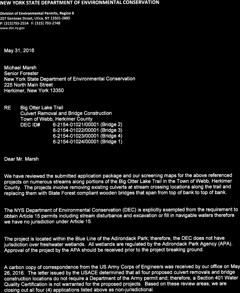
22 Date Received Central Office Department Authorization # /14/2016 L&F E-1 NEW YORK STATE DEPARTMENT OF ENVIRONMENTAL CONSERVATION CONCEPTUAL USE PLAN FOR ADMINISTRATIVE ACCESS BY MOTOR VEHICLE OR AIRCRAFT INTO WILDERNESS, PRIMITIVE AND CANOE AREAS For Aircraft Use in Wilderness: This Conceptual Use Plan must be approved by the Director of Lands & Forests and the Commissioner of DEC prior to submittal of a Request for Use of Aircraft for Program Support form. NOTE: Due to flight scheduling requirements, please submit this application 60 days prior to any proposed Wilderness flight(s). For Calendar Year: 2017 Part A: Applicant Information Name Michael Marsh Phone Number x118 Division Lands and Forests Program Forest Preserve Office Location Herkimer Part B: Area(s) to be Accessed and Intended Use Forest Preserve Unit(s) To Be Accessed Ha-De-Ron-Dah Wilderness Site(s) to be Accessed (list each trail, road, water body ) Purpose for Motor Vehicle/Aircraft Use Big Otter Lake Trail (Ha-De-Ron-Dah WA) Transport building materials for three replacement bridges within the Ha-Da-Ron-Dah Wilderness. Lumber and poles will be dropped off in close proximity to their respective sites using a helicopter sling load. 1 Conceptual Use Plan for Annual Administrative Access by Aircraft into Wilderness, Primitive and Canoe Areas Appendix E Rev
23 Alternatives to Motor Vehicle/Aircraft Use -Transport building materials 1.0 miles, 1.8 miles and 2.6 miles in by horses/hand to the project sites within the Ha-De-Ron-Dah Wilderness. -Use native materials. Impacts to Program if Aircraft Access in Wilderness is Eliminated -Horse teams have locally proven difficult to enlist/hire for these projects so materials probably would have to be staged by hand carry. -Greater staff time necessary to transport heavy materials long distances by hand over challenging terrain. -Increased frequency of maintenance associated with the shorter lifespan of native materials. Proposals to Reduce Use of Aircraft in Wilderness (Explain how this meets your Division s Wilderness Flights Reduction Plan) The use of treated materials will increase the lifespan of the bridges subsequently reducing the need for future aircraft operations into these areas. This flight serves multiple projects within this wilderness area and will be combined with other projects to the extent practical. Motor Vehicle/Aircraft Type UMP Authorized Project? Number of Flights/Trips (of each type) Frequency of Use Will You Be Landing? Duration Helicopter Yes (attach applicable pages from approved UMP) X No explain next box One X More than one specify next box X Daily Weekly Monthly Other specify next box Yes X No If Yes, explain why and for how long in next box Estimated Start Date: 01/01/ /15/2017 The APSLMP s Guidelines for Wilderness Management and Use permits the maintenance, rehabilitation and construction of necessary foot/horse bridges. An estimated 20 trips (flights) to haul materials in. Flight will be coordinated to occur within one to two work days, possibly longer if necessary. Estimated End Date: 01/01/ /15/2017 Estimated Time for Each Entry (hours): 8 Consolidated Flight? Yes, specify DEC Program next box X No Has this program been contacted and agrees to consolidated flight? Yes No 2 Conceptual Use Plan for Annual Administrative Access by Aircraft into Wilderness, Primitive and Canoe Areas Appendix E Rev

24 1/3/17
25 Digitally signed by Robert Davies Date: :46:03-05'00'
26
27 PUBLICATION OF NOTICE OF: Tree Cutting Notice Type of Notice: Tree Cutting Notice SEQR Status: Type 1 Unlisted _X_ DEC Region: 6 County: Herkimer Lead Agency: NYSDEC Project Title: Big Otter Lake Trail Rehabilitation Contact Person: Michael Marsh Address: 225 North Main St., Herkimer, NY Phone Number: michael.marsh@dec.ny.gov Project Location: Ha-De-Ron-Dah Wilderness Area, Town of Webb, Herkimer County, NY Project Description: Removal of a total of 60 trees 3 inches at Diameter Breast Height adjacent to three bridge construction sites along the Big Otter Lake Trail (Ha-De-Ron-Dah Wilderness Area). These areas (each approximately 40ft. by 40ft. in size) are to be cleared to facilitate a drop of bridge construction materials from a helicopter. The drop zone boundaries were inspected, selected and marked with Pink Flagging by Senior Forester Michael Marsh. Trees will be felled by DEC Operations Staff, cut into smaller pieces and left outside of the drop zone. A list of the identified trees is attached. DO NOT PRINT THIS BOX IN ENB - FOR YOUR INFORMATION ONLY If you have any questions on the above call Linda Kashdan-Schrom (518)
28
29
30
31
Crew Chief: Start Date: Completion Date: T & A Code:
 Completed Work Data Work order # Crew Chief: Start Date: Completion Date: T & A Code: Work Complete Comments: Personnel Service: Equipment: Item ID# Hours/Miles Rental Cost Supplies & Materials: Item Invoice#
16 June Conservation. Education
 16 June 2017 Conservation Education Recreation Since 1922 Member Services 814 Goggins Rd. Lake George, NY 12845-4117 Phone: (518) 668-4447 Fax: (518) 668-3746 e-mail: adkinfo@adk.org website: www.adk.org
Josh Clague, Natural Resources Planner NYS DEC 625 Broadway, 5th Floor Albany, NY Via
 16 June 2017 Conservation Education Recreation Since 1922 Member Services 814 Goggins Rd. Lake George, NY 12845-4117 Phone: (518) 668-4447 Fax: (518) 668-3746 e-mail: adkinfo@adk.org website: www.adk.org
112th CONGRESS. 1st Session H. R. 113 IN THE HOUSE OF REPRESENTATIVES
 HR 113 IH 112th CONGRESS 1st Session H. R. 113 To provide for additions to the Cucamonga and Sheep Mountain Wilderness Areas in the Angeles and San Bernardino National Forests and the protection of existing
Non-motorized Trail Plan & Proposal. August 8, 2014
 Town of Star Valley Ranch, Wyoming and the Star Valley Ranch Association in partnership with the USDA Forest Service, Bridger-Teton National Forest, Greys River Ranger District Non-motorized Trail Plan
January 31, Sherman Craig, Chairman NYS Adirondack Park Agency PO Box 99 Ray Brook, NY 12977
 Board of Directors Charles Clusen Chair Marilyn DuBois Sidney Harring Michael Wilson Vice-Chairs James McMartin Long Secretary David Quinn Treasurer Nancy Bernstein Richard Booth John Caffry Andy Coney
Mt. Hood National Forest
 United States Department of Agriculture Forest Service Mt. Hood National Forest Zigzag Ranger District 70220 E. Highway 26 Zigzag, OR 97049 503-622-3191 Fax: 503-622-5622 File Code: 1950-1 Date: June 29,
Bear Creek Habitat Improvement Project
 06/10/10 Bear Creek Habitat Improvement Project El Paso County, Colorado Pike National Forest and Colorado Springs Utilities Owned Land Report prepared by: Eric Billmeyer Executive Director Rocky Mountain
ATVANS Trail Assessment for Five Bridge Lakes Wilderness Area Report and Recommendation. December 28, Prepared by.
 ATVANS Trail Assessment for Five Bridge Lakes Wilderness Area Report and Recommendation December 28, 2011 Prepared by Peter Bush Background This report documents the results and recommendations of an all-terrain
Bradley Brook Relocation Project. Scoping Notice. Saco Ranger District. United States Department of Agriculture Forest Service
 Bradley Brook Relocation Project United States Department of Agriculture Forest Service Scoping Notice White Mountain National Forest February 2011 For Information Contact: Jenny Burnett White Mountain
Porter Fk. #1. All unauthorized items removed as per FS & Rec Res guidelines. Footbridge may be needed for wheel chair access and for safety
 APPENDIX D Lot Specific Permit Compliance & Forest Plan (FP) Requirements Porter Fork Recreation Residence Tract (Items noted were documented in compliance letter, 8/12/2005, sent to all Rec. Residence
Wilderness Areas Designated by the White Pine County bill
 Wilderness Areas Designated by the White Pine County bill SEC. 321. SHORT TITLE. This subtitle may be cited as the `Pam White Wilderness Act of 2006'. SEC. 322. FINDINGS. Congress finds that-- The White
Request for Proposal National Tropical Botanical Garden Lower Limahuli Preserve Emergency Stream Debris Removal
 Request for Proposal National Tropical Botanical Garden Lower Limahuli Preserve Emergency Stream Debris Removal I. Summary of Work Bids are solicited for the emergency removal of debris deposited in the
Mott Canyon Hazard Tree Incident
 Mott Canyon Hazard Tree Incident Lake Tahoe Basin Management Unit August 25, 2016 On August 25, 2016 while constructing a trail, John, a member of the Tahoe Rim Trail Association (TRTA) working under a
2018 Specifications & Pricing Guide. Check our website: for updates and new product offerings.
 2018 2018 & Pricing Guide December 20, 2017 Dear Valued Customer: The attached sales brochure includes specifications and pricing for offered by Company. For those of you who have placed orders in the
Proposed Backcountry Area Definition and Guidelines
 Proposed Backcountry Area Definition and Guidelines Proposed Backcountry Area Definition and Guidelines A Backcountry Area is proposed as a section of state land where the size and quality of the landscape
DRAFT. Dorabelle Campground Rehabilitation
 DRAFT Dorabelle Campground Rehabilitation September 2012 1.1 REGIONAL SETTING AND PROJECT LOCATION The Dorabelle Campground is located on the western shore of Shaver Lake in Fresno County, California (Section
TRAIL USER PERMIT FEE NATURAL RESOURCES, AGRICULTURE AND ENVIRONMENT INTERIM COMMITTEE
 TRAIL USER PERMIT FEE NATURAL RESOURCES, AGRICULTURE AND ENVIRONMENT INTERIM COMMITTEE Chris Haller Off-highway Vehicle Program Manager and Recreation Why? Motorized (Off-highway Vehicle-OHV) community
Lincoln County ORP Survey Response Summary
 Lincoln County ORP Survey Response Summary North Central Wisconsin Regional Planning Commission Q1 Which recreational activities did you participate in during 2015? (Choose all that apply.) Answered: 125
Daniel Mecklenburg 107 Old Wawbeek Road Tupper Lake, NY 12986
 December 2, 2015 NYS Adirondack Park Agency P.O. Box 99 1133 NYS Route 86 Ray Brook, NY 12977 Attention: Kathy Regan RE: Remsen-Lake Placid Travel Corridor Unit Management Plan -- proposed Alternative
1. Purpose and scope. a) the necessity to limit flight duty periods with the aim of preventing both kinds of fatigue;
 the necessity to limit flight duty periods with the aim of preventing both kinds of fatigue;") ATTACHMENT A. GUIDANCE MATERIAL FOR DEVELOPMENT OF PRESCRIPTIVE FATIGUE MANAGEMENT REGULATIONS Supplementary to Chapter 4, 4.2.10.2, Chapter 9, 9.6 and Chapter 12, 12.5 1. Purpose and scope 1.1 Flight
ATTACHMENT A. GUIDANCE MATERIAL FOR DEVELOPMENT OF PRESCRIPTIVE FATIGUE MANAGEMENT REGULATIONS Supplementary to Chapter 4, 4.2.10.2, Chapter 9, 9.6 and Chapter 12, 12.5 1. Purpose and scope 1.1 Flight
CRAZY HORSE TRAIL GUIDE
 CRAZY HORSE TRAIL GUIDE Abridged Version: July 2016 This is a short form of our interpretive trail guide for the Crazy Horse Trail. The full version of the guide has a more detailed description of the
APPENDIX D: SUSTAINABLE TRAIL DESIGN. APPENDICES Town of Chili Parks and Recreation Master Plan Update
 APPENDIX D: SUSTAINABLE TRAIL DESIGN APPENDICES Town of Chili Parks and Recreation Master Plan Update Sustainable Trail Construction Sustainable trails are defined by the US Forest Service as trails having
BOULDER CREEK CATTLE FENCING FOR KOKANEE HABITAT ENHANCEMENT 2010
 BOULDER CREEK CATTLE FENCING FOR KOKANEE HABITAT ENHANCEMENT 2010 Prepared for the: FISH & WILDLIFE COMPENSATION PROGRAM, NELSON, B.C. Prepared by: Marc André Beaucher CRESTON VALLEY WILDLIFE MANAGEMENT
S Central Coast Heritage Protection Act APRIL 21, 2016
 STATEMENT OF GLENN CASAMASSA ASSOCIATE DEPUTY CHIEF, NATIONAL FOREST SYSTEM U.S. FOREST SERVICE U.S. DEPARTMENT OF AGRICULTURE BEFORE THE UNITED STATES SENATE COMMITTEE ON ENERGY AND NATURAL RESOURCES
EMERALD ASH BORER (EAB) MANAGEMENT PLAN. For the Radisson Community Association. May 28, 2014
 MANAGEMENT PLAN. For the Radisson Community Association. May 28, 2014") EMERALD ASH BORER (EAB) MANAGEMENT PLAN For the Radisson Community Association May 28, 2014 Introduction: Emerald ash borer (EAB) Agrilus planipennis Fairmaire, is an invasive beetle that was discovered
EMERALD ASH BORER (EAB) MANAGEMENT PLAN For the Radisson Community Association May 28, 2014 Introduction: Emerald ash borer (EAB) Agrilus planipennis Fairmaire, is an invasive beetle that was discovered
5.0 OUTDOOR RECREATION OPPORTUNITIES AND MANAGEMENT
 5.0 OUTDOOR RECREATION OPPORTUNITIES AND MANAGEMENT 5.1 Introduction This section describes the range of recreational activities that currently take place in Marble Range and Edge Hills Parks, as well
Planning Future Directions. For BC Parks: BC Residents' Views
 Planning Future Directions For BC Parks: BC Residents' Views Summary Report Ministry of Water, Land and Air Protection Province of British Columbia April, 2002 National Library of Canada Cataloguing in
PROTECT Outlines Vision for Forest Preserve Classification of 69,000 Acres of former Finch/TNC Lands to be Purchased by the State
 PRESS RELEASE January 5, 013 PROTECT Outlines Vision for Forest Preserve Classification of 69,000 Acres of former Finch/TNC Lands to be Purchased by the State DEC also released its Conceptual Plan for
Agenda Report. Spruce Street Outlet Drainage Improvements Tower Road Relief Sewer
 Agenda Report Subject: Prepared By: Spruce Street Outlet Drainage Improvements Tower Road Relief Sewer Steven M. Saunders, Director of Public Works/Village Engineer Date: August 12, 2012 On March 8, 2012
FEASIBILITY CRITERIA
 This chapter describes the methodology and criteria used to evaluate the feasibility of developing trails throughout the study areas. Land availability, habitat sensitivity, roadway crossings and on-street
April 10, Mark Stiles San Juan Public Lands Center Manager 15 Burnett Court Durango, CO Dear Mark,
 Mark Stiles San Juan Public Lands Center Manager 15 Burnett Court Durango, CO 81301 Dear Mark, We are pleased to offer the following comments on the draft San Juan Public Lands Center management plans
Clearwater Lake Provincial Park. Draft Management Plan
 Clearwater Lake Provincial Park Draft Management Plan Clearwater Lake Provincial Park Draft Management Plan Table of Contents 1. Introduction... 3 2. Park History... 4 3. Park Attributes... 4 3.1 Location/Access...4
MANAGEMENT DIRECTION STATEMENT June, 1999
 Thompson River District MANAGEMENT DIRECTION STATEMENT June, 1999 for Roche Lake Provincial Park Ministry of Environment Lands and Parks BC Parks Division Table of Contents I. Introduction A. Setting
Bob Marshall Wilderness Foundation
 About the Bob Marshall Wilderness Complex Considered by many to be the crown jewel of the wilderness preservation system, the Bob Marshall Wilderness Complex located in Northwestern Montana, is the third
National Forests and Grasslands in Texas
 United States Department of Agriculture Forest Service National Forests and Grasslands in Texas Sam Houston NF 394 FM 1375 West New Waverly, Texas 77358 Phone 936-344-6205 Dear Friends, File Code: 1950
RULES OF TENNESSEE DEPARTMENT OF TRANSPORTATION AERONAUTICS DIVISION CHAPTER LICENSING AND REGISTRATION OF AIRPORTS TABLE OF CONTENTS
 RULES OF TENNESSEE DEPARTMENT OF TRANSPORTATION AERONAUTICS DIVISION CHAPTER 1680-1-2 LICENSING AND REGISTRATION OF AIRPORTS TABLE OF CONTENTS 1680-1-2-.01 Purpose 1680-1-2-.06 Repealed 1680-1-2-.02 Definitions
Snowmobile Connectors Are Disconnected
 Snowmobile Connectors Are Disconnected By Dave Gibson Adirondack Explorer MONDAY, AUGUST 10, 2015 The Boreas River and Route 28N where DEC proposes a new snowmobile bridge. Photo c Dave Gibson The contradictory,
Universal 10 x 27 Canopy
 Universal 10 x 27 Canopy C81027PC Size: 10 8 x 27 x 6 8 (side) x 9 9 (center) With 10 Legs, Frame, and Cover Powell & Powell Supply Company Distributed by: 1730 Five Points Lane Fuquay-Varina, North Carolina
Appendix A BC Provincial Parks System Goals
 Appendix A BC Provincial Parks System Goals The British Columbia Provincial Parks System has two mandates: To conserve significant and representative natural and cultural resources To provide a wide variety
Cultural Resource Management Report Deer Valley 4wd Restoration and Blue Lakes Road Maintenance Project R
 Cultural Resource Management Report R2015-05-03-10005 Undertaking Description: The proposes to perform road maintenance and meadow restoration on the Deer Valley 4wd trail and road maintenance on the Blue
Continental Divide National Scenic Trail Legislative History and Planning Guidance
 Continental Divide National Scenic Trail Legislative History and Planning Guidance Legislation, Policy, and Direction Regarding National Scenic Trails The National Trails System Act, P.L. 90-543, was passed
POLICY DCS-04: Tourism Directional Sign Policy. Development and Cultural Services
 DCS-04 Page 1 of 8 POLICY DCS-04: Tourism Directional Sign Policy Development and Cultural Services Approval Date: March 11, 2008 Approval Authority: Council, Resolution No. 7 Effective Date: March 11,
City of Durango 5.8 FUNDING TRAILS DEVELOPMENT
 5.8 FUNDING TRAILS DEVELOPMENT The City has been successful in establishing dedicated local funding sources as well as applying for grants to develop the City s trail system, having received nearly $2.4
STATE OF RHODE ISLAND AND PROVIDENCE PLANTATIONS PUBLIC UTILITIES COMMISSION
 STATE OF RHODE ISLAND AND PROVIDENCE PLANTATIONS PUBLIC UTILITIES COMMISSION IN RE: IGUS BEARINGS, INC. : DOCKET NO. 4652 PETITION FOR A PRIVATE AT-GRADE CROSSING : REPORT AND ORDER On September 30, 2016,
Decision Memo for Desolation Trail: Mill D to Desolation Lake Trail Relocation
 for Salt Lake County, Utah Uinta-Wasatch-Cache National Forest Salt Lake Ranger District 1. Background The present location of the Desolation Trail (#1159) between Mill D and Desolation Lake follows old
WORKSHEET 1 Wilderness Qualities or Attributes Evaluating the Effects of Project Activities on Wilderness Attributes
 WORKSHEET 1 Wilderness Qualities or Attributes Evaluating the Effects of Project Activities on Wilderness Attributes Date: 3/7/2017 Roadless Area: Ruby South Description of Project Activity or Impact to
Airworthiness Criteria: Special Class Airworthiness Criteria for the FlightScan
 This document is scheduled to be published in the Federal Register on 11/16/2017 and available online at https://federalregister.gov/d/2017-24866, and on FDsys.gov [4910-13] DEPARTMENT OF TRANSPORTATION
CONSERVATION VOLUNTEERS INTERNATIONAL PROGRAM VOLUNTEER TRIP TO TORRES DEL PAINE NATIONAL PARK, PATAGONIA, CHILE DECEMBER 2010
 CONSERVATION VOLUNTEERS INTERNATIONAL PROGRAM VOLUNTEER TRIP TO TORRES DEL PAINE NATIONAL PARK, PATAGONIA, CHILE DECEMBER 2010 We, Richard and Chris Braunlich, co-leaders of the volunteer trip, met the
Marchand Provincial Park. Management Plan
 Marchand Provincial Park Management Plan 2 Marchand Provincial Park Table of Contents 1. Introduction... 3 2. Park History... 3 3. Park Attributes... 4 3.1 Natural... 4 3.2 Recreational... 4 3.3 Additional
TAYLOR CANYON RANCH COLORADO - ROUTT COUNTY - STEAMBOAT SPRINGS
 TAYLOR CANYON RANCH COLORADO - ROUTT COUNTY - STEAMBOAT SPRINGS Tucked up against the steep valley shaped by Mt. Pau and rising to the Routt National Forest, Taylor Canyon Ranch is an easily accessible,
May 2, Kathleen D. Regan Deputy Director, Planning Adirondack Park Agency P.O. Box State Route 86 Ray Brook, NY 12977
 May 2, 2018 Kathleen D. Regan Deputy Director, Planning Adirondack Park Agency P.O. Box 99 1133 State Route 86 Ray Brook, NY 12977 RE: Amendments to the Adirondack Park State Land Master Plan (APSLMP)
MORGAN CREEK GREENWAY Final Report APPENDICES
 APPENDICES MORGAN CREEK GREENWAY Appendix A Photos of Existing Conditions in Trail Corridor Photos of existing conditions Main trail corridor - February 2009 Photos of existing conditions south bank Morgan
Minimum Requirements References in National Park Service Policy
 Minimum Requirements References in National Park Service Policy 2006 NPS Management Policies Chapter 6: Wilderness Preservation and Management 6.3 Wilderness Resource Management 6.3.1 General Policy (in
KAP Lot 3. Lot 3. Lot Lot 5. Lot 6. Lot 7. Lot 8. Lot KAP 81153
 Public Notice April 26, 2018 Subject Property: 249 Westminster Ave W Lot A, District Lot 4, Group 7, Similkameen Division Yale (Formerly Yale Lytton) District, KAP92015 Application: Rezone PL2018-8201
APPROVED MINUTES Public Works Commission November 10, 2010
 APPROVED MINUTES Public Works Commission November 10, 2010 Members Present: Members Absent: Alternate Present: Staff Present: Charles Bishop, Arthur Benson, Robert Guadagno and Patrick Kinney Dean Mitchell
DAMAGE ASSESSMENT OF SAND FENCING GARDEN CITY, NORTH LITCHFIELD AND LITCHFIELD BEACH GEORGETOWN COUNTY, SC
 OF SAND FENCING GARDEN CITY, NORTH LITCHFIELD AND LITCHFIELD BEACH GEORGETOWN COUNTY, SC June 07, 2017 PREPARED FOR: GEORGETOWN COUNTY DEPARTMENT OF PUBLIC SERVICES PREPARED BY: The EARTHWORKS Group 11655
As outlined in the Tatshenshini-Alsek Park Management Agreement, park management will:
 Management Strategy General Strategy The priority management focus for the park is to ensure that its internationally significant natural, cultural heritage and recreational values are protected and that
2017 Project Report: Priority 1 Trail Repairs - Boulder Ranger District Boulder Mountainbike Alliance
 2017 Project Report: Priority 1 Trail Repairs - Boulder Ranger District Boulder Mountainbike Alliance BMA partnered with the USFS Boulder Ranger District (USFS), to repair two flood-damaged trails (Sourdough
DeKalb County Government Sycamore, Illinois. Forest Preserve District Committee Minutes August 22, 2017
 Note: These minutes are not official until approved by the Forest Preserve District Committee at a subsequent meeting. Please refer to the meeting minutes when these minutes are approved to obtain any
NCUTCD Proposal for Changes to the Manual on Uniform Traffic Control Devices
 1 2 3 4 5 6 7 8 9 10 11 12 13 14 15 16 17 18 19 20 21 22 23 24 25 26 27 28 29 30 31 32 TECHNICAL COMMITTEE: ITEM NUMBER: TOPIC: ORIGIN OF REQUEST: AFFECTED SECTIONS OF MUTCD: NCUTCD Proposal for Changes
ROAD AND TRAIL PROJECT APPROVAL
 ROAD AND TRAIL PROJECT APPROVAL www.marincountyparks.org Marin County Parks, 3501 Civic Center Dr, Suite 260, San Rafael, CA 94903 DATE: July 12, 2017 PRESERVE: Gary Giacomini Open Space Preserve PROJECT:
A Publication of Friends of Sleeping Bear Dunes
 A Publication of Friends of Sleeping Bear Dunes 2014, Friends of Sleeping Bear Dunes, P.O. Box 545, Empire, MI 49630 www.friendsofsleepingbear.org info@friendsofsleepingbear.org Learn more about the Friends
BACKGROUND DECISION. Decision Memo Page 1 of 6
 DECISION MEMO DEVIL S ELBOW BY-PASS, BOUNDARY TRAIL NO.1 U.S. FOREST SERVICE T9N, R7E, SECTION 9 RANGE 5E COWLITZ COUNTY WA MOUNT ST. HELENS NATIONAL VOLCANIC MONUMENT, GIFFORD PINCHOT NATIONAL FOREST
GIRL SCOUTS OF MIDDLE TENNESSEE
 GIRL SCOUTS OF MIDDLE TENNESSEE SUMMER CAMP 2016 EMPLOYMENT OPPORTUNITIES OUR CAMPS Camp Holloway Camp Holloway exemplifies the rich history of Girl Scouts of Middle Tennessee. The camp, located on 80
Trail Management Objectives (TMO s)
") Trail Management Objectives (TMO s) TMO s are the foundation for solid, consistent trail planning, survey & design, construction, maintenance, periodic condition assessment & prescriptions, and on-going
Trail Management Objectives (TMO s) TMO s are the foundation for solid, consistent trail planning, survey & design, construction, maintenance, periodic condition assessment & prescriptions, and on-going
RECREATION. Seven issues were identified that pertain to the effects of travel management on outdoor recreation within portions of the project area.
 RECREATION Seven issues were identified that pertain to the effects of travel management on outdoor recreation within portions of the project area. OPPORTUNITIES FOR SOLITUDE / QUIET TRAILS. One attraction
Item # BJ2PC With 8 Leg Frame, Cover, and Enclosure Kit with Windows Size: 10 8 Wide x 20 Long (Side Height 6 8 ) (Center Peak Height 9 9 )
 (Center Peak Height 9 9 )") Item # BJ2PC With 8 Leg Frame, Cover, and Enclosure Kit with Windows Size: 10 8 Wide x 20 Long (Side Height 6 8 ) (Center Peak Height 9 9 ) Powell & Powell Supply Company, L.L.C. Manufactured by: 1730
Item # BJ2PC With 8 Leg Frame, Cover, and Enclosure Kit with Windows Size: 10 8 Wide x 20 Long (Side Height 6 8 ) (Center Peak Height 9 9 ) Powell & Powell Supply Company, L.L.C. Manufactured by: 1730
Environment and Natural Resources Trust Fund 2019 Request for Proposals (RFP)
") Environment and Natural Resources Trust Fund 2019 Request for Proposals (RFP) Project Title: Glacial Edge Trail and Downtown Pedestrian Bridge Category: G. Land Acquisition for Habitat and Recreation ENRTF
Environment and Natural Resources Trust Fund 2019 Request for Proposals (RFP) Project Title: Glacial Edge Trail and Downtown Pedestrian Bridge Category: G. Land Acquisition for Habitat and Recreation ENRTF
CHAPTER III: TRAIL DESIGN STANDARDS, SPECIFICATIONS & PERMITS
 CHAPTER III Trail Design Standards, Specifications & Permits This chapter discusses trail standards, preferred surface types for different activities, permits, and other requirements one must consider
Community Development Department Council Chambers, 7:30 PM, October 4, Related Case P: Site Plan Approval
 STAFF REPORT 2018-34P: Street Vacation Community Development Department Council Chambers, 7:30 PM, October 4, 2018 To: From: Re: Paul Luke, Chairman, Skokie Plan Commission Mike Voitik, Associate Planner
Permit Application Requirements For Temporary Tents, and Membrane Structures
 CTY OF PAM DESERT Building & Safety Department Permit Application Requirements For Temporary Tents, and Membrane Structures F O R M A T O A B U E T Revised 1-30-14 73510 Fred Waring Drive Palm Desert,
Chattahoochee- Oconee National Forests. Decision Memo
 Page 1 of 6 USDA Forest Service Chattahoochee- Oconee National Forests Decision Memo Chattahoochee-Oconee National Forests Home Page Recreation Information Forest History Forest Facts Forest Management
GOVERNMENT OF INDIA CIVIL AVIATION DEPARTMENT OC No. 02 of 2018 O/O DIRECTOR GENERAL OF CIVIL AVIATION DATE : 11 June 2018
 GOVERNMENT OF INDIA CIVIL AVIATION DEPARTMENT OC No. 02 of 2018 O/O DIRECTOR GENERAL OF CIVIL AVIATION DATE : 11 June 2018 1. Introduction OPERATIONS CIRCULAR File No. AV.22024/27/2016-FSD SUBJECT : HELICOPTER
Emily to Blind Lake Trail PROPOSED TRAIL DEVELOPMENT APPLICATION SUMMARY
 Emily to Blind Lake Trail PROPOSED TRAIL DEVELOPMENT APPLICATION SUMMARY Township 137 Range 26 (Fairfield Township) sections 2 & 3 Township 138 Range 26 (City of Emily) sections 27, 34, 35, & 36 Township
HIGHWAY RAIL GRADE CROSSING CONSOLIDATION PROGRAM
 HIGHWAY RAIL GRADE CROSSING CONSOLIDATION PROGRAM To decrease unnecessary train traffic exposure to life and property, promote public safety, and improve traffic conditions, the Texas Department of Transportation
Prior to contacting the Whitecourt Trailblazers Snowmobile Club, applicants must:
 WHITECOURT TRAILBLAZERS Box 607 Whitecourt, AB T7S 1N7 www.whitecourttrailblazers.ca CNT AMENDMENT Restriction Code 710: See Comments Comments All applicants are required to contact: Whitecourt Trailblazers
Economic Revitalization Zone Application Town of Salem Keewaydin Drive Extension April 2011
 Economic Revitalization Zone Application Town of Salem Keewaydin Drive Extension April 2011 11-25 Keewaydin New Hampshire Division of Economic Development Economic Revitalization Zone Tax Credits (Res
LOCAL PLAN FOR THE MANAGEMENT OF THE APPALACHIAN TRAIL IN MAINE. (GRAFTON NOTCH TO KATAHDIN) 1 January 2013 (Revised 5 February 2014)
 1 January 2013 (Revised 5 February 2014)") LOCAL PLAN FOR THE MANAGEMENT OF THE APPALACHIAN TRAIL IN MAINE (GRAFTON NOTCH TO KATAHDIN) 1 January 2013 (Revised 5 February 2014) The Appalachian Trail is a way, continuous from Katahdin in Maine to
LOCAL PLAN FOR THE MANAGEMENT OF THE APPALACHIAN TRAIL IN MAINE (GRAFTON NOTCH TO KATAHDIN) 1 January 2013 (Revised 5 February 2014) The Appalachian Trail is a way, continuous from Katahdin in Maine to
White Mountain National Forest Saco Ranger District
 United States Department of Agriculture Forest Service White Mountain National Forest 33 Kancamagus Highway Conway, NH 03818 Comm: (603) 447-5448 TTY: (603) 447-3121 File Code: 1950 Date: February 26,
Theme: Predominately natural/natural appearing; rustic improvements to protect resources. Size*: 2,500 + acres Infrastructure**:
 Recreation Opportunity Spectrum (ROS) Classes The Recreation Opportunity Spectrum (ROS) provides a way to describe the variations in the degree of isolation from the sounds and influences of people, and
The Frank Church River of No Return Wilderness
 ALLIANCE FOR WILDERNESS EDUCATION AND STEWARDSHIP PO Box 2667, Bellingham, WA 98227-2667 Tele: 360-927-1804 Fax: 360-527-9679 bradt@wildernessalliance.org www.wildernessalliance.org STEWARDS OF AMERICA
Project A: Revetment Scale: 1 = 10. 3/7 Revision: Benchmarks. Eroding Parking Area. View from Above. Locklies Creek. Ebb.
 Project A: Revetment Scale: 1 = 10 View from Above Floating Dock 3/7 Revision: Benchmarks 34 Locklies Creek Ebb Flood E. 18x8 Floating Dock Channelward of Vegetation 30 Class A1A Rip Rap MLW MHW 57 1 4
Minimum Impact Suppression Tactics Implementation Guidelines
 Minimum Impact Suppression Tactics Implementation Guidelines Establishing and Setting Up Camp Whenever possible, avoid establishing spike or coyote camps in Wilderness. If Wilderness camps are unavoidable,
2016 PRODUCTS & PRICES
 2016 PRODUCTS & PRICES LENGTH STOPS THAT ARE USER FRIENDLY Orders 1-800-821-3491 Phone 1-717-484-0230 Fax 1-717-484-0933 E-mail mayaposi@att.net Web mayaposi-stop.com MAYA POSITIONING EQUIPMENT MFG CO.
B HALL RANCH FISHTAIL, MONTANA
 Brochure Courtesy of: B HALL RANCH FISHTAIL, MONTANA w w w. m c c a s l i n l a n d. c o m Page 1 LOCATION The Hall Ranch is ideally located in the foothills of the Beartooth Mountains, approximately 5
Certificate of Release to Service (CRS)
") AIRWORTHINESS NOTICE Certificate of Release to Service (CRS) No 4 Issue 3 August 2010 1 Introduction 1.1 This Airworthiness Notice sets out to provide the necessary framework under which Certificate of
AIRWORTHINESS NOTICE Certificate of Release to Service (CRS) No 4 Issue 3 August 2010 1 Introduction 1.1 This Airworthiness Notice sets out to provide the necessary framework under which Certificate of
2 Section 45.11(d) states, in pertinent part, that on aircraft manufactured before March 7, 1988, the identification plate required by 45.
 states, in pertinent part, that on aircraft manufactured before March 7, 1988, the identification plate required by 45.") Exemption No.4988 UNITED STATES OF AMERICA DEPARTMENT OF TRANSPORTATION FEDERAL AVIATION ADMINISTRATION WASHINGTON, D.C. 20591 In the matter of the petition of THE SOARING SOCIETY OF AMERICA, Regulatory
Exemption No.4988 UNITED STATES OF AMERICA DEPARTMENT OF TRANSPORTATION FEDERAL AVIATION ADMINISTRATION WASHINGTON, D.C. 20591 In the matter of the petition of THE SOARING SOCIETY OF AMERICA, Regulatory
RE: Access Fund Comments on Yosemite National Park Wilderness Stewardship Plan, Preliminary Ideas and Concepts
 September 30, 2016 Superintendent Yosemite National Park Attn: Wilderness Stewardship Plan P.O. Box 577 Yosemite, CA 95389 RE: Access Fund Comments on Yosemite National Park Wilderness Stewardship Plan,
Proposed Scotchman Peaks Wilderness Act 2016 (S.3531)
") 1 Proposed Scotchman Peaks Wilderness Act 2016 (S.3531) Frequently Asked Questions PLACE Where is the area that would be designated as Wilderness? The lands outlined in S.3531 lie within Idaho along its
1 Proposed Scotchman Peaks Wilderness Act 2016 (S.3531) Frequently Asked Questions PLACE Where is the area that would be designated as Wilderness? The lands outlined in S.3531 lie within Idaho along its
BUCK POINT RANCH. Aspen Associates Realty
 BUCK POINT RANCH Aspen Associates Realty www.aspenassociatesrealty.com 970.544.5800 WELCOME TO Buck Point Ranch is a 960± acre property located in one of the last pristine valleys in close proximity to
Garnish Point Rosie Trail Association Inc.
 Garnish Point Rosie Trail Association Inc. P.O. Box 278, Garnish, NL Canada A0E 1TO Phone: 709.826.2290 Fax: 709.826.4991 Email: egrandy@yahoo.com http://www.townofgarnish.com/atv%20trail%20page.htm September
VARIOUS RESTRICTED CATEGORY HELICOPTERS
 Page 1 2012-14-11 VARIOUS RESTRICTED CATEGORY HELICOPTERS Amendment 39-17125 Docket No. FAA-2012-0739; Directorate Identifier 2012-SW-044-AD. PREAMBLE (a) Applicability This AD applies to Arrow Falcon
[Docket No SW-25-AD; Amendment ; AD R1]
![[Docket No SW-25-AD; Amendment ; AD R1]](/thumbs/94/120860064.jpg "[Docket No SW-25-AD; Amendment ; AD R1]") [Federal Register: July 6, 2004 (Volume 69, Number 128)] [Rules and Regulations] [Page 40539-40541] From the Federal Register Online via GPO Access [wais.access.gpo.gov] [DOCID:fr06jy04-4] DEPARTMENT OF
[Federal Register: July 6, 2004 (Volume 69, Number 128)] [Rules and Regulations] [Page 40539-40541] From the Federal Register Online via GPO Access [wais.access.gpo.gov] [DOCID:fr06jy04-4] DEPARTMENT OF
Payette National Forest Duty Station: New Meadows, Idaho Please respond by March 1, 2013
 THE OPPORTUNITY Payette National Forest Duty Station: New Meadows, Idaho Please respond by March 1, 2013 The Payette National Forest is currently seeking a candidate for a permanent full time Range Program
Public Comment. Comment To consider extending State Park lands above River Mile 7.0
 Public To consider extending Park lands above River Mile 7.0 on the Little Spokane River for the conservation and limited recreation qualities they contain is this request. Could this be included in your
COVER SHEET. Reduced Vertical Separation Minimum (RVSM) Information Sheet Part 91 RVSM Letter of Authorization
 Information Sheet Part 91 RVSM Letter of Authorization") COVER SHEET Reduced Vertical Separation Minimum (RVSM) Information Sheet Part 91 RVSM Letter of Authorization NOTE: FAA Advisory Circular 91-85 ( ), Authorization of Aircraft and Operators for Flight in
COVER SHEET Reduced Vertical Separation Minimum (RVSM) Information Sheet Part 91 RVSM Letter of Authorization NOTE: FAA Advisory Circular 91-85 ( ), Authorization of Aircraft and Operators for Flight in
Santa Clara South Hills Recreation Park Project Development and Management Plan
 Santa Clara South Hills Recreation Park Project Application for Land for Recreation or Public Purposes, City of Santa Clara, Utah Prepared for: Bureau of Land Management, St. George Field Office 345 East
Hospital Link Project Project Update September 2015
 Hospital Link Project Project Update September 2015 General The project provides a link between Riverside Drive and the Transitway to the Hospital Ring Road. This link is needed to improve transit service
FATALITY INVESTIGATION ACTIVITY #2
 FATALITY INVESTIGATION ACTIVITY #2 UNITED STATES DEPARTMENT OF LABOR MINE SAFETY AND HEALTH ADMINISTRATION Metal and Nonmetal Mine Safety and Health REPORT OF INVESTIGATION Surface Nonmetal Mine (Limestone)