Project A: Revetment Scale: 1 = 10. 3/7 Revision: Benchmarks. Eroding Parking Area. View from Above. Locklies Creek. Ebb.
|
|
|
- Todd Stephens
- 5 years ago
- Views:
Transcription
1
2 Project A: Revetment Scale: 1 = 10 View from Above Floating Dock 3/7 Revision: Benchmarks 34 Locklies Creek Ebb Flood E. 18x8 Floating Dock Channelward of Vegetation 30 Class A1A Rip Rap MLW MHW Bottom Width Salt Bush E. B.H @ MLW MHW Parking Area Cedar Applicant: Regent Point Marina, Inc. Proj. Address: 317 Regent Point Drive, Topping, VA County: Middlesex Proposed: Revetment, Pier Extensions, Breakwater Tax Map: A1 Waterway: Locklies Creek Agent: Michelle Meredith Date: February 10, 2011 Page: 1 of 5
3 Project A: Revetment Cross Sectional: Average 2:1 Slope Existing Grade Filter Cloth 4 2 H MLW MHW Applicant: Regent Point Marina, Inc. Proj. Address: 317 Regent Point Drive, Topping, VA County: Middlesex Proposed: Revetment, Pier Extensions, Breakwater Tax Map: A1 Waterway: Locklies Creek Agent: Michelle Meredith Date: February 10, 2011 Page: 2 of 5
4 Project B: Pier Extensions A Dock: 4 Additional Slips B Dock: 2 Additional Slips C Dock: 2 Additional Slips D Dock: 2 Additional Slips Total: 10 Additional Slips Locklies Creek Project B: Pier Extension Total after add. = Total after add. = 212 Total after add. = Total after add. = /7 Revision: MLW & MHW Flood Ebb Rappahannock River Project C: Breakwater MHW MLW Project A: Revetment MLW MHW Applicant: Regent Point Marina, Inc. Proj. Address: 317 Regent Point Drive, Topping, VA County: Middlesex Proposed: Revetment, Pier Extensions, Breakwater Tax Map: A1 Waterway: Locklies Creek Agent: Michelle Meredith Date: February 10, 2011 Page: 3 of 5

5 Project B: Pier Construction Pier constructed of 2x8 rough cut timber, foot 10 inch butt pilings and 8 inch top pilings. Pilings are placed 8 foot on center and deck boards are dressed. A Dock: 15x40 Slip 15x40 Slip Materials: 1. Lumber to be salt treated 2. All screws, bolts and hardware to be galvanized. Project C: Breakwater 15x40 Slip 15x40 Slip 6x36 Dock Two 3x22 Finger Piers Two 3x40 Finger Piers Mooring Piling B, C, D Dock: 15x40 Slip 15x40 Slip 6x18 Dock Two 3x40 Finger Piers Rappahannock River Locklies Creek Applicant: Regent Point Marina, Inc. Proj. Address: 317 Regent Point Drive, Topping, VA County: Middlesex Proposed: Revetment, Pier Extensions, Breakwater Tax Map: A1 Waterway: Locklies Creek Agent: Michelle Meredith Date: February 10, 2011 Page: 4 of 5
6 Project C: Breakwater Existing Pier & Timber Groin 144 3/7 Revision: Benchmarks Scale: 1 = MHW MLW Build Breakwater 4 above MHW 20 MHW MLW Class A1 Base over Filter Cloth Class II and III Outer Layer Cross Sectional: Base 8 14 Height with a 2/1 Slope Filter Cloth Note: Pier is the only structure within a 500 vicinity, therefore, benchmarks are from the pier MHW 10 MLW 6 View from Above: 144 Pier and Timber Groin 4 4 off the E. Groin Locklies Creek Base 36 Base Rappahannock River 42 Base Applicant: Regent Point Marina, Inc. Proj. Address: 317 Regent Point Drive, Topping, VA County: Middlesex Proposed: Revetment, Pier Extensions, Breakwater Tax Map: A1 Waterway: Locklies Creek Agent: Michelle Meredith Date: February 10, 2011 Page: 5 of 5
7
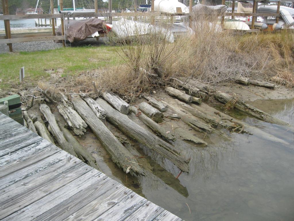
8 Dawn Fleming From: Woodward, Jay (MRC) Sent: Friday, April 01, :35 AM To: Howell, Beth (MRC); Cc: WETLANDS Subject: RE: Permit # Attachments: IMG_0689.JPG Thank you Michelle. We will withdraw this portion of the project from out review of the application. Accordingly, VMRC will only be authorizing the additional pier and slips requested at this time and that portion of the the riprap revetment in the cove portion that will extend channelward of mean low water. The intertidal portion of the revetment will need to be authorized by the Middlesex Wetlands Board first, and it will be up to the Board if they do or don't want to regulate the new pier and slip additions (no direct wetland impacts, but a commercial project that could have indirect impacts to the shoreline from additional boat traffic, etc.). In addition, during my on-site, Mr. Wagner indicated a willingness to have the timber piles (see picture) removed from the shoreline adjacent to the floating dock, though this is not specifically shown in the drawings, and any piles that may extend beyond (west) of the proposed riprap. VMRC would not object to this, nor would we believe that this removal and "restoration" of the area, require formal Board authorization. Again, we would leave that to the Board's decision, but I feel that would only enhance the project, the site, provided there is no excavation of the substrate, merely cutting and removing the old piles that are exposed currently. All that said, per our policy, the State will not act on our portion of the project until the Wetlands Board acts on theirs. Have a good weekend...think SUN...SPRING!?? Jay Jay Woodward Environmental Engineer, Sr. Virginia Marine Resources Commission Habitat Management Division 2600 Washington Ave., 3rd Floor Newport News, VA (757) From: htmpermits@aol.com [mailto:htmpermits@aol.com] Sent: Friday, April 01, :52 AM To: Howell, Beth (MRC); Woodward, Jay (MRC); d.kretz@co.middlesex.va.us Cc: wagnerj12@aol.com Subject: Permit # Good morning, In speaking to Mr. Wagner of Wagner Holdings, we have decided that it is best at this time to remove the Breakwater portion of his permit from the application. With the possibility of royalties and a design change, we feel that it may hold up the approval proceedings for the revetment and pier extentions. Mr. Wagner and I will pursue the breakwater portion with a new permit at a later date. If you have any questions or concerns about this removal, please do not hesitate to contact me at
9 Best regards, Michelle Meredith 2
10
11
12
13
14
15
16
17
18
19
20
21
22
23
24
25 Project A: Revetment Scale: 1 = 10 View from Above Floating Dock 3/7 Revision: Benchmarks 34 Locklies Creek Ebb Flood E. 18x8 Floating Dock Channelward of Vegetation 30 Class A1A Rip Rap 57 MLW MHW 1 4 Bottom Width Salt Bush E. B.H @ MLW MHW Parking Area Cedar Applicant: Regent Point Marina, Inc. Proj. Address: 317 Regent Point Drive, Topping, VA County: Middlesex Proposed: Revetment, Pier Extensions Tax Map: A1 Waterway: Locklies Creek Agent: Michelle Meredith Date: February 10, 2011 Page: 1 of 4

26 Project A: Revetment Cross Sectional: Average 2:1 Slope Existing Grade Filter Cloth 4 2 H MLW MHW Applicant: Regent Point Marina, Inc. Proj. Address: 317 Regent Point Drive, Topping, VA County: Middlesex Proposed: Revetment, Pier Extensions Tax Map: A1 Waterway: Locklies Creek Agent: Michelle Meredith Date: February 10, 2011 Page: 2 of 4
27 Project B: Pier Extensions A Dock: 4 Additional Slips B Dock: 2 Additional Slips C Dock: 2 Additional Slips D Dock: 2 Additional Slips Total: 10 Additional Slips Locklies Creek Project B: Pier Extension Total after add. = Total after add. = 212 Total after add. = Total after add. = /7 Revision: MLW & MHW Flood Ebb Rappahannock River MHW MLW Project A: Revetment Applicant: Regent Point Marina, Inc. Proj. Address: 317 Regent Point Drive, Topping, VA County: Middlesex Proposed: Revetment, Pier Extensions Tax Map: A1 Waterway: Locklies Creek Agent: Michelle Meredith Date: February 10, 2011 Page: 3 of 4
28 Project B: Pier Construction Pier constructed of 2x8 rough cut timber, foot 10 inch butt pilings and 8 inch top pilings. Pilings are placed 8 foot on center and deck boards are dressed. A Dock: 15x40 Slip 15x40 Slip Materials: 1. Lumber to be salt treated 2. All screws, bolts and hardware to be galvanized. 15x40 Slip 15x40 Slip 6x36 Dock Two 3x22 Finger Piers Two 3x40 Finger Piers Mooring Piling B, C, D Dock: 15x40 Slip 15x40 Slip 6x18 Dock Two 3x40 Finger Piers Applicant: Regent Point Marina, Inc. Proj. Address: 317 Regent Point Drive, Topping, VA County: Middlesex Proposed: Revetment, Pier Extensions Tax Map: A1 Waterway: Locklies Creek Agent: Michelle Meredith Date: February 10, 2011 Page: 4 of 4
City of Fort Lauderdale. Frequently Asked Questions. Proposed Sea Wall Ordinance
 City of Fort Lauderdale Frequently Asked Questions Proposed Sea Wall Ordinance The City of Fort Lauderdale is considering amending the Unified Land Development Regulations of the City of Fort Lauderdale
ORDINANCE NO. C-16- WHEREAS, the proposed minimum seawall elevation exceeds the current maximum by 0.7 feet (8.4 inches); and
; and") ORDINANCE NO. AN ORDINANCE AMENDING THE UNIFIED LAND DEVELOPMENT REGULATIONS OF THE CITY OF FORT LAUDERDALE, FLORIDA, AMENDING SECTION 47-19.3, BOAT SLIPS, DOCKS, BOAT DAVITS, HOISTS AND SIMILAR MOORING
ORDINANCE NO. AN ORDINANCE AMENDING THE UNIFIED LAND DEVELOPMENT REGULATIONS OF THE CITY OF FORT LAUDERDALE, FLORIDA, AMENDING SECTION 47-19.3, BOAT SLIPS, DOCKS, BOAT DAVITS, HOISTS AND SIMILAR MOORING
5 September 9, 2015 Public Hearing
 5 September 9, 2015 Public Hearing APPLICANT: SHIP CABIN CLUB, INC. PROPERTY OWNER: RED HEAD REALTY CORPORATION REQUEST: Enlargement of a Nonconforming Use and Structures STAFF PLANNER: Kevin Kemp ADDRESS
Aid to Local Ports FY19 Requests
 City Accomack- Greenbackville Harbor Phase III Accomack-Quinby Harbor Bulkhead Cape Charles- Installation of 4 th breakwater Total Project Cost Amount Requested Proposed Allocation Carryover Request $260,000.00
Crew Chief: Start Date: Completion Date: T & A Code:
 Completed Work Data Work order # Crew Chief: Start Date: Completion Date: T & A Code: Work Complete Comments: Personnel Service: Equipment: Item ID# Hours/Miles Rental Cost Supplies & Materials: Item Invoice#
New Orleans Municipal Yacht Harbor
 New Orleans Municipal Yacht Harbor 2018 Capital Projects Construction Updates MYH Floating Marina Community Sailing Center (Coordination with) MYH Boat Launch (MYHMC) MYH Administration Building (CPA &
Indiana Department of Natural Resources / Division of Water
 The Department of Natural Resources is providing this report to satisfy the requirements of the "Procedures Concerning Certain Licenses Act", IC 14-11-4, and its associated administrative rule, 312 IAC
Header i
 Header i 048285014.10 Header Sub Title Body Text here. Body text here. Body text here. Section 1... 1 Executive Summary... 1 Opportunities and Constraints... 3 Overall Opportunities and Constraints Map
Northern Rail Extension, Phase One
 General Project and Funding 1. Where does Phase One start? The rail line for Phase One begins roughly at the northern boundary of the former Bradbury property, but also includes work along Tom Bear Trail
HARBOR INFRASTRUCTURE INVENTORIES Erie Harbor, PA
 HARBOR INFRASTRUCTURE INVENTORIES Erie Harbor, PA Harbor Location: Erie Harbor is located on the southern shore of Lake Erie in the City of Erie, PA about 98 Miles southwest of Buffalo. Authority: River
GARFIELD BRIDGE. Building A Bridge to No-Where
 GARFIELD BRIDGE Building A Bridge to No-Where OCEANA COUNTY LOCATION Garfield Road leads to Stony Lake Outlet, a Benona Township park and popular Lake Michigan access GARFIELD BRIDGE OVER STONY CREEK
COATING AND STRUCTURAL CONCRETE COATING (ANTI-GRAFFITI) 1'-3" FINISHED GRADE 1'-3" 3" VENEER ALLOWANCE LEDGER W/ MECHANICAL ANCHOR BOLT
 1'-3 FINISHED GRADE 1'-3 3 VENEER ALLOWANCE LEDGER W/ MECHANICAL ANCHOR BOLT") R "W" PAY LIMITS OF ITEM 601 PAY LIMITS OF ITEM 601 STRUCTURAL CONCRETE STRUCTURAL CONCRETE 1'3" PCBC END SEGMENT B C 1'3" COATING AND STRUCTURAL CONCRETE COATING (ANTIGRAFFITI) 1'3" CURB FINISHED GRADE
R "W" PAY LIMITS OF ITEM 601 PAY LIMITS OF ITEM 601 STRUCTURAL CONCRETE STRUCTURAL CONCRETE 1'3" PCBC END SEGMENT B C 1'3" COATING AND STRUCTURAL CONCRETE COATING (ANTIGRAFFITI) 1'3" CURB FINISHED GRADE
The Galveston Seawall
 Coastal and Ocean Engineering ENGI.8751 Undergraduate Student Forum Faculty of Engineering and Applied Science, Memorial University, St. John s, NL, Canada. March, 2013 The Galveston Seawall Mark Harvey
THAT the Board approve the final proposed concept plan for the Jericho Marginal Wharf site as shown in Figure C-4 of Appendix C.
 Date: January 17, 2012 TO: Board Members Vancouver Park Board FROM: General Manager Parks and Recreation SUBJECT: Jericho Marginal Wharf Phase 2 Concept Plan RECOMMENDATION THAT the Board approve the final
Decision Memo for Desolation Trail: Mill D to Desolation Lake Trail Relocation
 for Salt Lake County, Utah Uinta-Wasatch-Cache National Forest Salt Lake Ranger District 1. Background The present location of the Desolation Trail (#1159) between Mill D and Desolation Lake follows old
Reduction of Wave Runup on a Revetment by Addition of a Berm
 REMR Technical Note CO-RR-1.3 (Supersedes CO-RR-1.3 1986) Reduction of Wave Runup on a Revetment by Addition of a Berm Purpose To provide design guidance for reducing wave runup on a riprap revetment by
Impact of Offshore Directed Forcing on Sediment Transport and Structural Integrity at Packery Channel, Corpus Christi Texas
 Google Earth 29 Aug 2017 Impact of Offshore Directed Forcing on Sediment Transport and Structural Integrity at Packery Channel, Corpus Christi Texas Deidre D. Williams Coastal Research Scientist Conrad
March 2, The Honorable Mayor Williams D. Sessoms, Jr. Members of City Council. Subject: Coastal CIP Presentation to City Council - March 6, 2018
 OFFICE OF THE CITY MANAGER (757) 385-4242 (757) 427-5626 FAX MUNICIPAL CENTER BUILDING 1, ROOM 234 2401 COURTHOUSE DRIVE VIRGINIA BEACH, VA 23456-9001 March 2, 2018 The Honorable Mayor Williams D. Sessoms,
Amended Maintenance Dredge Spoil Management Plan. Shute Harbour Marina Resort
 Amended Maintenance Dredge Spoil Management Plan Shute Harbour Marina Resort Amended Maintenance Dredge Spoil Management Plan Quality Information Document Ref Amended Maintenance Dredge and Spoil Maintenance
SECTION SPECIFICATIONS PART 1 GENERAL
 PART 1 GENERAL 1.1 SECTION INCLUDES A. Shower doors. B. Sliding enclosures. C. Shower doors and panels. 1.2 RELATED SECTIONS A. Section 06100 - Rough Carpentry; blocking. B. Section 15400 - Plumbing Fixtures
Application for Permit to Develop in a Floodplain Area
 Application for Permit to Develop in a Floodplain Area The undersigned hereby makes application for a permit to develop in a designated floodplain area. The work to be performed is described below and
WAIMAKARIRI DISTRICT COUNCIL REPORT. Craig Sargison, Manager Community and Recreation
 WAIMAKARIRI DISTRICT COUNCIL REPORT FILE NO: GOV-26-01-07, CPR-04-04-01 / 150609090834 REPORT TO: Kaiapoi Community Board DATE OF MEETING: 15 June 2015 FROM: SUBJECT: Craig Sargison, Manager Community
On Pistakee Bay At 1222 Old Bay Road Near McHenry In Unincorporated McHenry County, Illinois (Section 19, T45N, R9E)
") 16 Apr 2003 Regulatory Branch PUBLIC NOTICE ------------- 1. Pursuant to Code of Federal Regulations 33 CFR 325.2(a)(8), the Chicago District issued permits or other approvals, withdrawals, appeals or
16 Apr 2003 Regulatory Branch PUBLIC NOTICE ------------- 1. Pursuant to Code of Federal Regulations 33 CFR 325.2(a)(8), the Chicago District issued permits or other approvals, withdrawals, appeals or
Crew Chief: Start Date: Completion Date: T & A Code:
 Completed Work Data Work order # Crew Chief: Start Date: Completion Date: T & A Code: Work Complete Comments: Personnel Service: Equipment: Item ID# Hours/Miles Rental Cost Supplies & Materials: Item Invoice#
Community Development
 Community Development City & Borough of Juneau Community Development 155 S. Seward Street Juneau, AK 99801 (907) 586 0715 Phone (907) 586 4529 Fax DATE: February 11, 2016 TO: FROM: Planning Commission
AND PERMITTEE DATE LOCATION OF WORK
 04 Aug 2003 Regulatory Branch PUBLIC NOTICE ------------- 1. Pursuant to Code of Federal Regulations 33 CFR 325.2(a)(8), the Chicago District issued permits or other approvals, withdrawals, appeals or
May 2002 Replacement of Existing Rip Leisure Village Association Rap on the Northwestern
 06 Jun 2002 Regulatory Branch PUBLIC NOTICE ------------- 1. Pursuant to Code of Federal Regulations 33 CFR 325.2(a)(8), the Chicago District issued permits or other approvals, withdrawals, appeals or
INSTALLATION INSTRUCTIONS for folding arm awnings
 Custom made Awnings and Blinds Item No 0757 INSTALLATION INSTRUCTIONS for folding arm awnings IMPORTANT INFORMATION BEFORE INSTALLING YOUR Updated 08/09/15 AN AWNING INSTALLATION IS A HOME IMPROVEMENT
Design and Construction of Berm Breakwaters
 Design and Construction of Berm Breakwaters Jentsje van der Meer - Van der Meer Consulting UNESCO-IHE Sigurdur Sigurdarson - Icelandic Road and Coastal Administration IceBreak Consulting Engineers New
MINUTES OF MEETING OF WAREHAM CONSERVATION COMMISSION
 MINUTES OF MEETING OF WAREHAM CONSERVATION COMMISSION Date of Meeting: January 3, 2018 I. CALL MEETING TO ORDER The meeting was called to order at 7:02 P.M. II. ROLL CALL Members Present: Members Absent:
Staff Report on Brevard County Area Projects (See pages 32-60) Staff will present a report on District Projects in the Brevard County area.
 Staff will present a report on District Projects in the Brevard County area.") Call to Order - Chair Netts will call the meeting to order. Pledge of Allegiance - Commissioner Sansom will lead the Pledge of Allegiance. Roll Call - Secretary Gernert will call the roll. Additions or
Call to Order - Chair Netts will call the meeting to order. Pledge of Allegiance - Commissioner Sansom will lead the Pledge of Allegiance. Roll Call - Secretary Gernert will call the roll. Additions or
Danvers River Committee Thursday April 20, 2017 Meeting Minutes
 Danvers River Committee Thursday April 20, 2017 Meeting Minutes The Danvers River Committee held a public meeting on Thursday April 20, 2017 in the Town Manager s Conference Room, Danvers Town Hall, at
SECTION 55A1 ROBINSON TOWNSHIP IN WASHINGTON COUNTY
 WEEK ENDING FEBRUARY 1, 2019 SECTION 55A1 ROBINSON TOWNSHIP IN WASHINGTON COUNTY Contractor: Independence Excavating Inc. 1. Work Shift Day shift (M-F), with Saturday as a makeup day. 2. Traffic The new
January 19, 2018 Project No C Via
 Mr. Thomas McDonald, P.E. Professional Engineer II (C/E) Water Management NYS Canal Corporation 30 S Pearl Street Albany, NY 12207 January 19, 2018 Project No. 16-5719C Via email: thomas.mcdonald@canals.ny.gov
The History & Management of the Atlantic Intracoastal Waterway in Florida
 The History & Management of the Atlantic Intracoastal Waterway in Florida THE BEGINNING OF THE INTRACOASTAL WATERWAY IN FLORIDA CONSTRUCTED BY A PRIVATE COMPANY, THE FLORIDA EAST COAST CANAL COMPANY BETWEEN
crrv OF DALLAS Memorandum Trinity River Corridor Project Update On Recreation
 Memorandum OATE December 8, 2011 crrv OF DALLAS TO Trinity River Corridor Project Committee Members: Vonciel Jones Hill (Chair) Linda Koop (Vice Chair), Monica Alonzo, Scott Griggs, Angela Hunt, Delia
Figure 7. Dragline at Cape Coral, Figure 8. Cape Coral oblique aerial photograph, 1959.
 The dredge-and-fill method, which would later be criticized for its environmental impact, employed in the peak years of the early 1960s as many as four dredges and ten draglines, which at times operated
how it started where we are now what is coming up NEW WESTMINSTER WATERFRONT PARK THE RIVER THE PAST THE PEOPLE
 how it started Downtown Waterfront Park How It Started March 2009 City of New Westminster Purchases 3.2 Hectare Westminster Pier Site March 2009 City of New Westminster and Design Team develop plan for
Mollusk Restoration around Wastewater Treatment Plant (NY) # Progress Report: August 26, 2011
 # Progress Report: August 26, 2011") To date, the project has involved numerous teleconferences, emails and permitting exercises with the goal of ribbed mussel seed collection, construction and installation of a mussel raft in the Bronx/East
To date, the project has involved numerous teleconferences, emails and permitting exercises with the goal of ribbed mussel seed collection, construction and installation of a mussel raft in the Bronx/East
Common Ground Drainage Channel Diversion. Design Report
 Common Ground Drainage Channel Diversion Design Report Resource Management International Inc Consulting Engineers May 2017 COMMON GROUND DRAINAGE CHANNEL DIVERSION PREPARED FOR: QUILL LAKES WATERSHED NO.
HARBOR INFRASTRUCTURE INVENTORIES Buffalo Harbor, New York
 HARBOR INFRASTRUCTURE INVENTORIES Buffalo Harbor, New York Harbor Location: Buffalo Harbor is located on the Eastern shore of Lake Erie in the City of Buffalo, NY. Authority: River & Harbor Acts of 1826,
CHAPTER 16 STREETS, SIDEWALKS AND OTHER PUBLIC PLACES*
 CHAPTER 16 STREETS, SIDEWALKS AND OTHER PUBLIC PLACES* *Cross reference(s)--drainage commission, 2-111 et seq.; drainage districts created, 2-114; planning commission shall select and recommend to the
VERSION DATE OF ISSUE DESCRIPTION PREPARED CHECKED APPROVED Technical note HHP DKA OYBE
 DRAMMENREGIONENS VIRKESTERMINALER DEVELOPMENT OF NEW TIMBER TERMINAL NAVIGATION AND BERTH LOCATION STUDY ADDRESS COWI A/S Parallelvej 2 2800 Kongens Lyngby Denmark TEL +45 56 40 00 00 FAX +45 56 40 99
The Charleston Style Awning Charleston Style Awning Frame must be installed on the wall as there is no connecting part between AA and TB
 The Charleston Style Awning Charleston Style Awning Frame must be installed on the wall as there is no connecting part between AA and TB ASSEMBLY AND INSTALLATION INSTRUCTIONS CAUTION: When you are opening
HARBOR INFRASTRUCTURE INVENTORIES Cleveland Harbor, OH
 HARBOR INFRASTRUCTURE INVENTORIES Cleveland Harbor, OH Harbor Location: Cleveland Harbor is located at the mouth of the Cuyahoga River on the southern shore of Lake Erie in the city of Cleveland, OH. Authority:
New ADA Accessibility Standards for the Attractions Industry
 New ADA Accessibility Standards for the Attractions Industry 1 New ADA Accessibility Standards for the Attractions Industry 2 INTERNATIONAL ASSOCIATION OF AMUSEMENT PARKS AND ATTRACTIONS WEBINAR DISCLAIMER
Fee if structure is a boathouse or covered dock. For one structure or one boat $ $ For one structure or one boat $ $110.
 ACTION: Final DATE: 12/04/2014 10:43 AM 1501:41-2-08 Seasonal dock fees. (A) Persons who have a private structure built on state lands or in state waters or extending on or over the waters of the division
The next day we cut, cruise taped and permolated the track from Explorer to the
 Report on Explorer Hut On our first trip three people flew into Explorer at 4 PM on Monday 10 th August 2016 and spent the next couple of hours cutting back the scrub around the chopper pad and then started
Contractors and Service Providers Registered to Work on Arrowhead Lake Association Properties April 1, 2018 March 31, 2019
 Contractors and Service Providers Registered to Work on Arrowhead Lake Association Properties April 1, 2018 March 31, 2019 Licensed Dock Contractors All American Dock Pros, LLC. (Aaron Lawler) P.O. Box
Mountain Valley Pipeline, LLC Mountain Valley Pipeline Project Docket No. CP
 16. Prior to construction, Mountain Valley shall file with the Secretary, for review and approval by the Director of OEP, a segment-specific construction and operation access plan for the area between
ASTM E 1886 and ASTM E 1996 TEST REPORT. Report No.: A Rendered to: CORAL ARCHITECTURAL PRODUCTS Tuscaloosa, Alabama
 Architectural Testing ASTM E 1886 and ASTM E 1996 TEST REPORT Report No.: A2651.02 401 44 Rendered to: CORAL ARCHITECTURAL PRODUCTS Tuscaloosa, Alabama PRODUCT TYPE: 90 Corner Curtain Wall SERIES/MODEL:
City of Haslett. City of East Lansing. City of East Lansing
 Central Park North (Nancy L. Moore Park) Lake Park North Expansion White Park Expansion #2 White Park Expansion #1 County East East Haslett East East TF87-212 Acquisition $90,000.00 Park. TF08-138 Acquisition
Understanding user expectations And planning for long term sustainability 1
 Understanding user expectations And planning for long term sustainability 1 What is a natural surface trail? It can be as simple has a mineral soil, mulched or graveled pathway, or as developed as elevated
April 4, 2014 Chuck McGinness, FDOT TREASURE COAST TRAFFIC REPORT April 4 through April 11, 2014
 April 4, 2014 Chuck McGinness, 954-777-4090 Chuck.McGinness@dot.state.fl.us FDOT TREASURE COAST TRAFFIC REPORT April 4 through April 11, 2014 TREASURE COAST Construction and maintenance-related lane closures
BUILD. In this issue: NEW AERIALS OF CONSTRUCTION NEW PROJECT IN CONSTRUCTION PAC K AG E 4. August 2018
 BUILD C O N ST R U C T I O N Update August 2018 In this issue: NEW AERIALS OF CONSTRUCTION NEW PROJECT IN CONSTRUCTION PAC K AG E 4 AVENUE 12 CEDAR VIADUCT A VIEW FROM ROAD 27 ABOVE HSR CONSTRUCTION FRESNO
DOOR - Single Leaf, Premium Duty, Quick-Acting Model 1430 Features 1
 DOOR - Single Leaf, Premium Duty, Quick-Acting Model Features 1 FREEMAN MARINE Quick-Acting doors feature patented chain-drive, single actuation dogging. This design feature allows for quick-acting doors
Chesapeake Bay Preservation Area Board
 City of Chesapeake MINUTES The Chesapeake Bay Preservation Area Board Planning Department 306 Cedar Road PO Box 15225 Chesapeake, Virginia 23328 (757) 382-6176 FAX: (757) 382-6406 Chesapeake Bay Preservation
Canal Winchester. Town Hall 10 North High Street Canal Winchester, OH Meeting Minutes. Monday, August 14, :00 PM
 Canal Winchester Town Hall 10 North High Street Canal Winchester, OH 43110 Meeting Minutes Monday, August 14, 2017 7:00 PM Planning and Zoning Commission Bill Christensen Chairman Michael Vasko Vice Chairman
HARBOR INFRASTRUCTURE INVENTORIES Duluth-Superior Harbor, Minnesota/Wisconsin
 HARBOR INFRASTRUCTURE INVENTORIES Duluth-Superior Harbor, Minnesota/Wisconsin Harbor Location: Duluth-Superior Harbor is located at the westernmost tip of Lake Superior. Authority: River & Harbor Act of
Task Force Meeting #2
 Task Force Meeting #2 July 9, 2013 Project Precedents Granville Island, Vancouver B.C. South Waterfront, Portland OR Jack London Square, Oakland CA Brooklyn Basin, Oakland CA Chula Vista Bayfront, Chula
Neighborhood Dredging SSD Program. Brief to Beaches & Waterways Commission
 Neighborhood Dredging SSD Program Brief to Beaches & Waterways Commission August 4, 2011 1 Neighborhood Channel Dredging Program Initiative Supports City Council Goal #4: Revitalize Neighborhoods and Plan
ROAD AND TRAIL PROJECT APPROVAL
 ROAD AND TRAIL PROJECT APPROVAL www.marincountyparks.org Marin County Parks, 3501 Civic Center Dr, Suite 260, San Rafael, CA 94903 DATE: July 12, 2017 PRESERVE: Gary Giacomini Open Space Preserve PROJECT:
EAST DON TRAIL ENVIRONMENTAL ASSESSMENT. Community Liaison Committee Meeting #3 July 15, :30 to 8:30 pm Flemingdon Park Library
 EAST DON TRAIL ENVIRONMENTAL ASSESSMENT Community Liaison Committee Meeting #3 July 15, 2013 6:30 to 8:30 pm Flemingdon Park Library Agenda 1. Welcome 2. Housekeeping and Updates a) Housekeeping b) CLC
SOL VS.2a, 2b, 2c, 10b
 What are the characteristics of the Coastal Plain? 1. Also known as Tidewater 2. Located near the Atlantic Ocean and the Chesapeake Bay 3. Includes the Eastern Shore, a peninsula between the Atlantic Ocean
CHAPTER 4 -- THE LAND USE PLAN: DESCRIPTIONS AND POLICIES FOR THIRTEEN PLANNING AREAS
 CHAPTER 4 -- THE LAND USE PLAN: DESCRIPTIONS AND POLICIES FOR THIRTEEN PLANNING AREAS NORTH CENTRAL CAC PLANNING AREA 4.4 FORT BRAGG CITY LIMIT TO HARE CREEK PLANNING AREA (Includes Noyo) The Noyo community
SUBJECT: Newark Bay Study Area Coordination Team Meeting, 9 October 2012
 CENAN-PP-H 9 Oct 12 MEMORANDUM FOR RECORD SUBJECT: Newark Bay Study Area Coordination Team Meeting, 9 October 2012 1. The regularly scheduled monthly interagency coordination meeting was held on 9 Oct
THOMAS AND TALBOT REAL ESTATE A Staunch Supporter of Land Easements
 For more information please contact John Coles at 540.270.0094 THOMAS AND TALBOT REAL ESTATE A Staunch Supporter of Land Easements Land and Estate Agents since 1967 Middleburg, VA 20118 540.687.6500 www.thomas-talbot.com
Acquisition in fee simple of approximately one-half acre of property on the shore of Spring Lake to expand the Lakeside Beach Park.
 Lakeside Beach TF00-136 $122,550.00 in fee simple of approximately one-half acre of property on the shore of Spring Lake to exp the Lakeside Beach. 2000 River Ravines TF00-150 $910,000.00 in fee simple
Mount Rainier National Park November 2006 Flood Damage
 On November 6 and 7, 2006, Mount Rainier National Park received 18 inches of rain in 36 hours. This presentation summarizes the extensive flood damage that occurred throughout the park. Updated November
Staff Report. Re: National Park Service Ferry Landing Facilities at Piers 31, 31½ and 33 Joint Meeting with BCDC Design Review Board
 Port of San Francisco Waterfront Design Advisory Committee Agenda Item No. 1 Meeting Date: Staff Report To: From: Waterfront Design Advisory Committee: Laura Crescimano Jeff Joslin Marsha Maytum Kathrin
BEAVER LAKE ACCESS AREA SUMMARY 2017 Edition
 BEAVER LAKE ACCESS AREA SUMMARY 2017 Edition DEVELOPED BY THE BEAVER LAKE PROPERTY and SAFETY COMMITTEE 2 October 2017 1 NOTICE: This document supersedes and nullifies all previous versions of Beaver Lake
 CEMVP-PD-C MEMORANDUM FOR FILE SUBJECT: Supplement No. 4,, Design Memorandum 10, Kaskaskia River, Illinois 1. References: a., Design Memorandum No. 10, approved 1997 (includes Supplements 1-3) b. ER 1130-2-550,
Installation Instructions Traditional Awnings in a box Classic Awnings in a Box
 Installation Instructions Traditional Awnings in a box Classic Awnings in a Box Basic Tools Required (not included) Tape Measure & Pencil Level Phillips Screwdriver Drill with ¼ bit (Cement or Masonry
Water Space. A development opportunity at the Canting Basin, Pacific Quay, Glasgow
 Water Space A development opportunity at the Canting Basin, Pacific Quay, Glasgow Summary Canting Basin Lower Harbour The Pacific Quay development, which Graving Docks Quay includes the new BBC Scotland
Chair and Members of Harbour East - Marine Drive Community Council. Brad Anguish, Director, Parks and Recreation
 P.O. Box 1749 Halifax, Nova Scotia B3J 3A5 Canada Item No. 15.1.1 Harbour East-Marine Drive Community Council December 3, 2015 TO: SUBMITTED BY: Chair and Members of Harbour East - Marine Drive Community
AJW. Athletic Series Lockers. Architectural Products ONE TIER TWO TIER THREE TIER FOUR TIER FIVE TIER SIX TIER
 ONE TIER TWO TIER THREE TIER FOUR TIER FIVE TIER SIX TIER Specifications Body: Backs constructed of mild cold rolled 18 ga. commercial grade steel. Bottom, sides, top, and shelves constructed of 16 ga.
Required Showing for Route 205 Mattox Creek Bridge Replacement F07 Contract Project Number: , C501 - UPC Thursday January 16, 2014
 Required Showing for Route 205 Mattox Creek Bridge Replacement F07 Contract Project Number: 0205-096-109, C501 - UPC 76266 Thursday January 16, 2014 Only contractors who were present at the showing will
PRELIMINARY STAFF PLANNING REPORT TO THE WALWORTH COUNTY ZONING AGENCY X CONDITIONAL USE
 This report was prepared prior to the public hearing. This report may be supplemented or amended to reflect the review of additional information presented at the public hearing and written material submitted
Marine Exchange of Alaska Port of Juneau Navigation Study
 Safe, Secure, Efficient and Environmentally Responsible Maritime Operations 1000 Harbor Way, Juneau, Alaska 99801 Ph: (907) 463-2607 December 10, 2008 Mr. John Stone Port Director City of Juneau 155 S.
WHATCOM COUNTY PLANNING & DEVELOPMENT SERVICES PERMITS RECEIVED. 12/1/2016 to 12/31/2016
 5280 Northwest Ave. Bellingham, WA 98226 Phone 360-676-6907 WHATCOM COUNTY PLANNING & DEVELOPMENT SERVICES PERMITS RECEIVED 12/1/2016 to 12/31/2016 1/5/2017 Shoreline Conditional Use Permits: 12/1/2016
DAMAGE ASSESSMENT OF SAND FENCING GARDEN CITY, NORTH LITCHFIELD AND LITCHFIELD BEACH GEORGETOWN COUNTY, SC
 OF SAND FENCING GARDEN CITY, NORTH LITCHFIELD AND LITCHFIELD BEACH GEORGETOWN COUNTY, SC June 07, 2017 PREPARED FOR: GEORGETOWN COUNTY DEPARTMENT OF PUBLIC SERVICES PREPARED BY: The EARTHWORKS Group 11655
MEETING OF JUNE 27, 2016 OF THE TRUSTEES OF THE FREEHOLDERS AND COMMONALTY OF THE TOWN OF EAST HAMPTON
 MEETING OF JUNE 27, 2016 OF THE TRUSTEES OF THE FREEHOLDERS AND COMMONALTY OF THE TOWN OF EAST HAMPTON Present: Not Present: Also Present: Francis Bock, Trustee Clerk Bill Taylor, Deputy Clerk Tyler Armstrong
Porter Fk. #1. All unauthorized items removed as per FS & Rec Res guidelines. Footbridge may be needed for wheel chair access and for safety
 APPENDIX D Lot Specific Permit Compliance & Forest Plan (FP) Requirements Porter Fork Recreation Residence Tract (Items noted were documented in compliance letter, 8/12/2005, sent to all Rec. Residence
Chicago Style Awning
 Chicago Style Awning ASSEMBLY AND INSTALLATION INSTRUCTIONS CAUTION: When you are opening the box keep children away. This awning frame contains sharp metal and small hardware parts. Choking hazard: Keep
Galveston Bay Estuary Program. Carla G. Guthrie, Ph.D. Galveston Bay Council Member Texas Water Development Board
 Galveston Bay Estuary Program Carla G. Guthrie, Ph.D. Galveston Bay Council Member Texas Water Development Board The statements contained in this presentation are my current views and opinions and are
02 Aug 2002 PUBLIC NOTICE
 02 Aug 2002 Regulatory Branch PUBLIC NOTICE ------------- 1. Pursuant to Code of Federal Regulations 33 CFR 325.2(a)(8), the Chicago District issued permits or other approvals, withdrawals, appeals or
Appendix 3. Greenway Design Standards. The Whitemarsh Township Greenway Plan
 Appendix 3 Greenway Design Standards This chapter discusses two design standards for the greenway types discussed above. First, trail design standards are presented together with trailhead facilities and
Crossing the Keweenaw Waterway in an Emergency with a U.S Army Floating Bridge
 Crossing the Keweenaw Waterway in an Emergency with a U.S Army Floating Bridge Photo: John Kiefer William Leder, Adjunct Professor (Ret.) Department of Civil and Environmental Engineering Contributions
Executive Summary of Urgent Field Survey of Earthquake and Tsunami Disasters by the 2011 off the Pacific coast of Tohoku Earthquake
 March 25, 2011 Executive Summary of Urgent Field Survey of Earthquake and Tsunami Disasters by the 2011 off the Pacific coast of Tohoku Earthquake Port and Airport Research Institute (PARI) has accomplished
VDOT HOT SPOTS IN THE FREDERICKSBURG DISTRICT
 RELEASE: IMMEDIATE Aug. 10, 2018 CONTACT: Darragh Frye 540 899 4119 (office) 540 907 8409 (cell) Darragh.Frye@VDOT.Virginia.gov VDOT HOT SPOTS IN THE FREDERICKSBURG DISTRICT August 12 August 18, 2018 All
NORTH HEMPSTEAD BEACH PARK MASTER PLAN
 NORTH HEMPSTEAD BEACH PARK MASTER PLAN COMMUNITY DESIGN CHARRETTE Supervisor Judi Bosworth Viviana L. Russell Peter J. Zuckerman Angelo P. Ferrara Anna M. Kaplan Lee R. Seeman Dina M. De Giorgio VISIONING
BRAND-OGRAPHY. Katarina Baumann
 BIRD ISLAND PELICAN POINT POWER STATION OUTER HARBOR NORTH HAVEN BIODIVERSITY PARK MUTTON COVE ADELAIDE LEFEVRE PENINSULA Scale 1:25000 NORTH HAVEN MARINA TAPEROO FORMER PENRICE FACTORY SITE TORRENS ISLAND
Everett Riverwalk Life style explore
 Life style explore Project Overview The 217-acre Everett Riverfront redevelopment is visible from I-5 with traffic counts charted at 170,000+ vehicles per day with direct freeway access from 4-way interchange.
Proposed Project 1: Kimble Loop East Horse Trail Reroute (1). Horse Trail Reroute: March 14, 2012
. Horse Trail Reroute: March 14, 2012") Proposed Project 1: Kimble Loop East Horse Trail Reroute The Ironton District Ranger requests your comments on proposed trail project on National Forest System lands. (1). Horse Trail Reroute: The proposed
Proposed Project 1: Kimble Loop East Horse Trail Reroute The Ironton District Ranger requests your comments on proposed trail project on National Forest System lands. (1). Horse Trail Reroute: The proposed
TRAFFIC ALERT FOR JANUARY 15-19, 2018 Highway Work Zones in the Staunton District
 RELEASE: IMMEDIATE January 11, 2018 CONTACT: Sandy Myers 540-332-9201 (office) STA18-007 540-292-2500 (cell) Sandy.Myers@VDOT.virginia.gov Ken Slack 540-332-9264 (office) 540-414-5670 (cell) Ken.Slack@VDOT.virginia.gov
SUMMARY OF THE MEETING OF THE WOODS HOLE, MARTHA S VINEYARD AND NANTUCKET STEAMSHIP AUTHORITY. September 25, 2018
 SUMMARY OF THE MEETING OF THE WOODS HOLE, MARTHA S VINEYARD AND NANTUCKET STEAMSHIP AUTHORITY September 25, 2018 The members of the Woods Hole, Martha s Vineyard and Nantucket Steamship Authority ( SSA
Weekly Bid Results. Friday, January 20, Broadway Storm Drain, 400 North to 700 North - T. CRL Litter Fence - Casper
 Broadway Storm Drain, 400 North to 700 North - T Bid Date 1/17/2017 Location Tooele, UT $557,740.00 Silver Spur Construction $598,614.00 Newman $626,804.37 Broken Arrow $634,825.00 Dennis Leer II Construction
Hydraulic Report. Trail 5 Snowmobile Trail Over Mulligan Creek. Prepared By: COLEMAN ENGINEERING COMPANY Karisa V. Falls, P.E.
 Prepared for: Prepared by: Marquette County Road Commission Coleman Engineering Company Marquette, Michigan Iron Mountain, MI December 2011 Hydraulic Report Trail 5 Snowmobile Trail Over Mulligan Creek
Bostonian style (DOME) Awning ASSEMBLY AND INSTALLATION INSTRUCTIONS
 Awning ASSEMBLY AND INSTALLATION INSTRUCTIONS") Bostonian style (DOME) Awning ASSEMBLY AND INSTALLATION INSTRUCTIONS CAUTION: When you are opening the box keep children away. This awning frame contains sharp metal and small hardware parts. Choking hazard:
Bostonian style (DOME) Awning ASSEMBLY AND INSTALLATION INSTRUCTIONS CAUTION: When you are opening the box keep children away. This awning frame contains sharp metal and small hardware parts. Choking hazard:
BIRD RIVER COTTAGE OWNERS ASSOCIATION Annual General Meeting September 1, 2013 Executive Members in Attendance: Wally Stewart
 BIRD RIVER COTTAGE OWNERS ASSOCIATION Annual General Meeting September 1, 2013 Executive Members in Attendance: Wally Stewart Larry Bellefeuille Carol Guicheret Martin Hafichuk Chad McDaniel Rudy Peters