Occurrence of Dry and Wet Periods in Altitudinal Vegetation Stages of West Carpathians in Slovakia: Time-Series Analysis
|
|
|
- Jordan Harvey
- 5 years ago
- Views:
Transcription

1 Occurrence of Dry and Wet Periods in Altitudinal Vegetation Stages of West Carpathians in Slovakia: Time-Series Analysis J. Hrvoľ,, J. J Škvarenina,, J. J Tomlain, J. Škvareninová,, P. Nejedlík
2 Vegetation stages /Zlatnik,, 1976/ 1st Oak 2nd Beech-Oak 3rd Oak-beech 4th Beech 5th Fir-beech 6th Spruce- fir-beech 7th Spruce 7th Spruce & 8th Mountain pine 5 % of terr

3 Vegetation stages. Oak. Beech-oak. Oak-beech. Beech. Fir-beech. Spruce-beeh-fir. Spruce. Dwarf pine. Alluvial communities

4 Where are we? Area
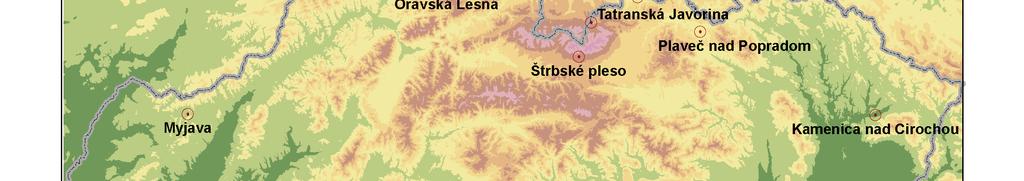
5
6


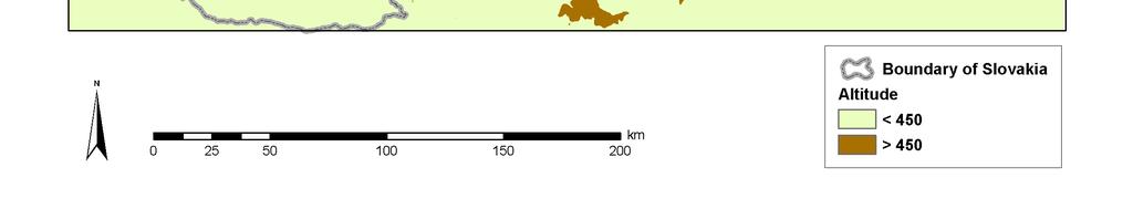
7 50000km 2, mean altitude 450 m a.s.l., 41% of territora covered by forests
8 Stations
9 Drought Natural Climate Variability T I M E D u r a t i o n Precipitation deficiency High temp., high winds, (amount, intensity, low relative humidity, timing) greater sunshine, less cloud cover Reduced infiltration, runoff, deep percolation, and ground water Increased evaporation recharge and transpiration Soil water deficiency Plant water stress, reduced biomass and yield Reduced streamflow, inflow to reservoirs, lakes and ponds; reduced wetlands, wildlife habitat Meterological Drought Agricultural Drought Hydrological Drought Economic Impacts Social Impacts Environmental Impacts Socioeconomicenvironmental Drought
10 Methodology Evaluated parameters /annual and seasonal values/: -Precipitation, P [mm] -Potential evapotranspiration, E 0 [mm] -Actual evapotranspiration, E [mm] -Relative evapotranspiration, E/E 0 [%] -Drought index, E 0 /P [-]
11 Definitions E 0 maximal possible evapotranspiration under the given energy condition /no water shortage/ E the evapotranspirarion under the real energy and water supply conditions E = E o.w/w o W - water stored in the upper soil layer of 1 m depth W o - the critical value above which E equals E o
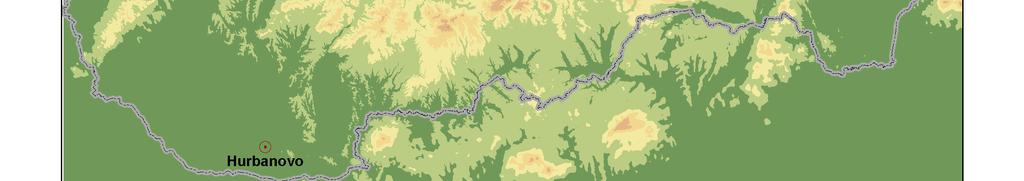
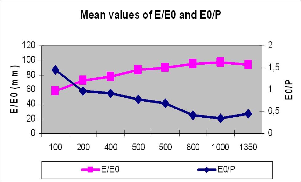
12 Average annual values of precipitation (P), potential (Eo( Eo), actual evapotranspiration (E), drought index (Eo( Eo/P) and relative evapotranspiration (E/Eo Eo) ) at chosen localities of Slovakia for in Meteorological station H [m a.s.l.] P [mm] Eo [mm] E [mm] E/Eo [%] Eo/P [ - ] Vegetation stage Hurbanovo ,44 1 st Oak Myjava ,96 2 nd Beech-Oak Kamenica n. C ,92 3 rd Oak-beech Plaveč ,78 4 th Beech Červený Kláštor ,69 5 th Fir-beech Oravská Lesná ,42 6 th Spruce- fir-beech Tatranská Javorina ,35 7 th Spruce Štrbské Pleso ,45 7 th Spruce & 8 th Mountain pine
13
14 Annual trend analysis ( ) of E/Eo Eo and (Eo/P). Probability level *p* < 0.1, **p < 0.05, ***p < 0.01, ****p < 0.001, n.s.. not significant Meteorological station E/Eo = f (years) Trend Eo/P = f (years) Trend Hurbanovo ** aridity *** aridity Myjava ** aridity n.s. - Kamenica n. C. n.s. - n.s. - Plaveč **** humidity **** humidity Červený Kláštor * humidity ** humidity Oravská Lesná n.s. - n.s. - Tatranská Javorina n.s. - **** humidity Strbske Pleso n.s. - * humidity
15 The dependence of relative evapotranspiration annual values (E/Eo Eo) on altidude [m a.s.l.].] in Slovakia in /logaritmic scale/ E/Eo [%] y = Ln(x) R 2 = altitude [m]
16 The dependence of drought index annual values (Eo( Eo/P) on altidude [m a.s.l.].] in Slovakia in /logarithmic logarithmic scale/ Eo/P y = Ln(x) R 2 = altitude [m]
17 The course of annual values of (E/Eo Eo) in Hurbanovo in linear trend and polynomial of 3rd order E/Eo [%] y = x x x - 1E+06 R 2 = y = x R 2 = year
18 The course of annual values of (Eo/P) in Hurbanovo in linear trend and polynomial trend of 3rd order Eo/P y = x R 2 = y = 3E-06x x x R 2 = year
19 The course of annual values of (E/Eo Eo) in Plaveč in linear trend and polynomial of 3rd order E/Eo [%] y = x R 2 = y = x x x + 2E+06 R 2 = year
20 The course of annual values of (Eo/P) in Plaveč in linear trend and polynomial trend of 3rd order Eo/P y = x R 2 = y = 5E-06x x x R 2 = year
21 Conclusions - Relative evapotranspiration and drought index, were used to characterise the energetic and humidity conditions of Slovakia There are two different climatic zones /temperate and boreal/ The relative evapotranspiration shows values as from 97 % in the northern mountainous regions, to 58 % in the Danubian lowland. A significant increase in the severity of drought was identified only in the Danube Lowland (1st Oak vegetation stage) and in Zahorská Lowland (2nd Beech-Oak vegetation stage); a significant trend of increasing humidity in mountains and in the northern part of East Slovakia.
Flora Distribution Types and Migration of the Flora
 Flora The evolution of the flora and vegetation started at the end of the late glacial period, about 12,000 years BP (Before Present). The mountains became covered by sparse pine and birch woodlands and
Traffic Forecasts. CHAOUKI MUSTAPHA, Economist, International Civil Aviation Organization
 SIP/2009-WP/11 Business case Traffic Forecasts CHAOUKI MUSTAPHA, Economist, International Civil Aviation Organization Workshop on the Development of Business Case for the Implementation of CNS/ATM Systems
Geoscape Toronto The Oak Ridges Moraine Activity 2 - Page 1 of 10 Information Bulletin
 About 13,000 years ago as the Laurentide Ice Sheet melted, glacial meltwater accumulated between the ice sheet and the Niagara Escarpment. This formed a lake basin into which gravel and sand were deposited.
Actual Climatic Conditions in ERB. Online Resource 1 corresponding to:
 Actual Climatic Conditions in ERB. Online Resource 1 corresponding to: Article Title: Climatic Trends and Impact of Climate Change on Agriculture in an Arid Andean Valley. Journal Name: CLIMATIC CHANGE
Analysis of rainless periods within the DriDanube project
 Analysis of rainless periods within the DriDanube project Bojan Srđević & FAUNS Team FAUNS Faculty of Agriculture, University of Novi Sad, Serbia Training course on drought risk assessment, at OMSZ Hungarian
Hydrological study for the operation of Aposelemis reservoir Extended abstract
 Hydrological study for the operation of Aposelemis Extended abstract Scope and contents of the study The scope of the study was the analytic and systematic approach of the Aposelemis operation, based on
Nansanga Profile. Population and Land Use.
 Nansanga Profile Population and Land Use. Settlements in Nansanga are linearly aggregated in plateau area along the Serenje Mapepala road, with densely populated Mukomansala, Mapepala, Shindaila, and Nabowa
DriDanube. Drought Risk in the Danube Region. Department of Geodesy and Geoinformation (GEO) Vienna University of Technology (TU Wien)
 Vienna University of Technology (TU Wien)") DriDanube Drought Risk in the Danube Region Department of Geodesy and Geoinformation (GEO) Vienna University of Technology (TU Wien) Vienna, 4 April 2018 DriDanube Drought Risk in the Danube Region Project
DriDanube Drought Risk in the Danube Region Department of Geodesy and Geoinformation (GEO) Vienna University of Technology (TU Wien) Vienna, 4 April 2018 DriDanube Drought Risk in the Danube Region Project
The Role of Glaciers in the Hydrologic Regime of the Nepal Himalaya. Donald Alford Richard Armstrong NSIDC Adina Racoviteanu NSIDC
 The Role of Glaciers in the Hydrologic Regime of the Nepal Himalaya Donald Alford Richard Armstrong NSIDC Adina Racoviteanu NSIDC Outline of the talk Study area and data bases Area altitude distributed
Seasonal Variability of the Groundwater Regime for Several Aquifers in Bulgaria Tatiana Orehova 1
 Seasonal Variability of the Groundwater Regime for Several Aquifers in Bulgaria Tatiana Orehova 1 The purpose of the paper is to analyse the seasonal variability of the groundwater regime for several aquifers
Climate change impacts on stand production and survival, and adaptation strategies to build resilience
 Climate change impacts on stand production and survival, and adaptation strategies to build resilience Jody Bruce, Michael Battaglia and Libby Pinkard July 14 CSIRO LAND AND WATER Potential impact Exposure
Integrated Monitoring Network in Poland Current Status and Future Perspectives
 Integrated Monitoring Network in Poland Current Status and Future Perspectives Krzysztof Skotak, Tomasz Pecka Institute of Environmental Protection National Research Institute (IOŚ-PIB) Joint ICP IM &
Public Works Research Institute
 Public Works Research Institute INTERNATIONAL WORKSHOP ON WATER HAZARD AND RISK MANAGEMENT SOME EXPERIENCES OF FLOOD MANAGEMENT IN ARGENTINA VÍCTOR POCHAT National Director for Water Policies,Coordination
Federal Hydrometeorological Institute of Bosnia and Herzegovina S A R A J E V O
 Federal Hydrometeorological Institute of Bosnia and Herzegovina S A R A J E V O Department of Agrometeorology, Agrometeorology in Bosnia and Herzegovina, current status and activities Hydrometeorological
Characteristics and climatic sensitivities of runoff from a cold-type glacier on the Tibetan Plateau
 HYDROLOGICAL PROCESSES Hydrol. Process. 21, 2882 2891 (2007) Published online 7 December 2006 in Wiley InterScience (www.interscience.wiley.com).6505 Characteristics and climatic sensitivities of runoff
GRANDE News Letter Volume1, No.3, December 2012
 GRANDE News Letter Volume1, No.3, December 2012 Building a water management system in La Paz, Bolivia Climate change is a phenomenon that affects the entire world, but its impact on people differs depending
A high resolution glacier model with debris effects in Bhutan Himalaya. Orie SASAKI Kanae Laboratory 2018/02/08 (Thu)
") A high resolution glacier model with debris effects in Bhutan Himalaya Orie SASAKI Kanae Laboratory 2018/02/08 (Thu) Research flow Multiple climate data at high elevations Precipitation, air temperature
A high resolution glacier model with debris effects in Bhutan Himalaya Orie SASAKI Kanae Laboratory 2018/02/08 (Thu) Research flow Multiple climate data at high elevations Precipitation, air temperature
Rainfall Appendix. Summary Statistics of Rainfall Data for Sites in the West-Central Florida. A Simple Conceptualized Rainfall/Discharge Relationship
 Rainfall Appendix Summary Statistics of Rainfall Data for Sites in the West-Central Florida A Simple Conceptualized Rainfall/Discharge Relationship Stream or river flows are, of course, integrally associated
REPUBLIC HYDROMETEOROLOGICAL SERVICE OF SERBIA. MEDARE 3 rd Expert Group Meeting Istanbul, Turkey September 2012
 REPUBLIC HYDROMETEOROLOGICAL SERVICE OF SERBIA MEDARE 3 rd Expert Group Meeting Istanbul, Turkey 27 28 September 2012 BRIEF HISTORY Meteorological and hydrological activity in the territory of Serbia has
Phoenix Habitat Restoration Projects
 Phoenix Habitat Restoration Projects Spur Cross Ranch Cave Creek (Estergard) Regional Tree and Shade Summit March 9, 2010 Desert Riparian Ecosystems Healthy riparian areas like this once existed along
Water resources cycle in karst (feasibility studies and engineering design; case studies)
") Water resources cycle in karst (feasibility studies and engineering design; case studies) Prof. emeritus Ognjen Bonacci Faculty of Civil Engineering, Architecture and Geodesy, Split University E-mail:
Water resources cycle in karst (feasibility studies and engineering design; case studies) Prof. emeritus Ognjen Bonacci Faculty of Civil Engineering, Architecture and Geodesy, Split University E-mail:
Coverage of Mangrove Ecosystem along Three Coastal Zones of Puerto Rico using IKONOS Sensor
 Coverage of Mangrove Ecosystem along Three Coastal Zones of Puerto Rico using IKONOS Sensor Jennifer Toledo Rivera Geology Department, University of Puerto Rico, Mayagüez Campus P.O. Box 9017 Mayagüez,
2.1 What is the climate like?
 José Medeiros This fact sheet allows you to see how varied the countryside is across Brazil. 2.1 What is the climate like? Most of Brazil is in the Southern Hemisphere, where the seasons are the opposite
Chapter 7 Snow and ice
 Chapter 7 Snow and ice Throughout the solar system there are different types of large ice bodies, not only water ice but also ice made up of ammonia, carbon dioxide and other substances that are gases
EXPLORING BIOMES IN GORONGOSA NATIONAL PARK
 EXPLORING BIOMES IN GORONGOSA NATIONAL PARK ABOUT THIS WORKSHEET This worksheet complements the Click and Learn Gorongosa National Park Interactive Map (http://www.hhmi.org/biointeractive/gorongosa-national-park-interactive-map),
The Problem.. SuDS: Controlling the Flow. LANDF RM Technical delivery of SuDS 15/10/2013. Bridget Woods Ballard HR Wallingford 1.
 SuDS: Controlling the Flow 15th October 2013 Bridget Woods Ballard The Problem.. Page 2 Bridget Woods Ballard HR Wallingford 1 15th October 2013 Landform Event Page 3 HR Wallingford 2013 The Aim of SuDS.
ORTHOLOGICAL MANAGEMENT OF HYDROLOGICAL RUNOFF BASINS OF THE PREFECTURE OF DRAMA (CURRENT SITUATION PROTECTIVE ACTIONS PERSPECTIVES)
") ORTHOLOGICAL MANAGEMENT OF HYDROLOGICAL RUNOFF BASINS OF THE PREFECTURE OF DRAMA (CURRENT SITUATION PROTECTIVE ACTIONS PERSPECTIVES) This paper presents the torrential environment of the torrents of the
ORTHOLOGICAL MANAGEMENT OF HYDROLOGICAL RUNOFF BASINS OF THE PREFECTURE OF DRAMA (CURRENT SITUATION PROTECTIVE ACTIONS PERSPECTIVES) This paper presents the torrential environment of the torrents of the
Jeneberang River. Serial No. : Indonesia-10 Location: South Sulawesi Area: 727 km 2 Origin: Mt. Bawakaraeng (2,833 MSL) Outlet: Makassar Strait
 Outlet: Makassar Strait") Jeneberang River Map of River Table of Basic Data Name: Jeneberang River Serial No. : Indonesia-10 Location: South Sulawesi S 5 10' 00" - 5 26' 00" E 119 23' 50" - 119 56' 10" Area: 727 km 2 Origin: Mt.
Jeneberang River Map of River Table of Basic Data Name: Jeneberang River Serial No. : Indonesia-10 Location: South Sulawesi S 5 10' 00" - 5 26' 00" E 119 23' 50" - 119 56' 10" Area: 727 km 2 Origin: Mt.
UNIT 5 AFRICA PHYSICAL GEOGRAPHY SG 1 - PART II
 UNIT 5 AFRICA PHYSICAL GEOGRAPHY SG 1 - PART II III. CLIMATE & VEGETATION A. The four main climate zones are tropical wet, tropical wet/dry (split into monsoon & savanna), semiarid, and arid. Other climate
International Sava River Basin Commission
 International Sava River Basin Commission Pilot project on climate change: Building the link between the Flood Risk Management planning and climate change assessment in the Sava River Basin climate change
Figure 1 shows the evaluation area around Tailings Basin Cells 2E/1E. Two areas were evaluated for potential wetland impacts including:
 Barr Engineering Company 4700 West 77th Street Minneapolis, MN 55435-4803 Phone: 952-832-2600 Fax: 952-832-2601 www.barr.com An EEO Employer Minneapolis, MN Hibbing, MN Duluth, MN Ann Arbor, MI Jefferson
New measurements techniques
 2 nd Asia CryoNetWorkshop New measurements techniques Xiao Cunde (SKLCS/CAS and CAMS/CMA) Feb.5, 2016, Salekhard, Russia Outline Definition of New Some relative newly-used techniques in China -- Eddy covariance
RECREATION POTENTIAL ASSESMENT AS ASSUMPTION FOR TOURISM REGIONALIZATION OF SLOVAKIA TERRITORY
 RECREATION POTENTIAL ASSESMENT AS ASSUMPTION FOR TOURISM REGIONALIZATION OF SLOVAKIA TERRITORY Jan SUPUKA - Roberta ŠTĚPÁNKOVÁ Slovak Agriculture University in Nitra, The Slovak Republic International
Statistical Evaluation of BMP Effectiveness in Reducing Fecal Coliform Impairment in Mermentau River Basin
 Statistical Evaluation of BMP Effectiveness in Reducing Fecal Coliform Impairment in Mermentau River Basin Z.-Q. Deng 1 and H. Chowdhary 2 1 Assistant Professor, Department of Civil and Environmental Engineering,
Hydrological Data HYDROLOGICAL MODELS
 HYDROLOGICAL MODELS There is no doubt that the driving force in a wetland is the water, and the dynamics of water is what characterizes each particular wetland ecosystem. Hence, its was of outmost importance
Snow, Glacier and GLOF
 Snow, Glacier and GLOF & Report on Demonstration River Basin Activities Upper Indus Basin The 5th International Coordination Group (ICG) Meeting GEOSS Asian Water Cycle Initiative (AWCI) Tokyo, Japan,
Hydrology of Yemen. Dr. Abdulla Noaman
 Hydrology of Yemen Dr. Abdulla Noaman INTRODUCTION Location and General Topography Yemen is located on the south of the Arabian Peninsula, between latitude 12 and 20 north and longitude 41 and 54east,
USING RESULTS OF MODELLED YIELD DEVIATION AND INDICES OF WEATHER EXTREMES TOWARDS A BETTER YIELD ASSESSMENT CURRENT STATE OF RESEARCH
 USING RESULTS OF MODELLED YIELD DEVIATION AND INDICES OF WEATHER EXTREMES TOWARDS A BETTER YIELD ASSESSMENT CURRENT STATE OF RESEARCH Lalic, B., Eitzinger, J., Thaler, S., Nejedlik, P., Kazandjiev, V.,
Assessment of glacier water resources based on the Glacier Inventory of China
 104 Annals of Glaciology 50(53) 2009 Assessment of glacier water resources based on the Glacier Inventory of China KANG Ersi, LIU Chaohai, XIE Zichu, LI Xin, SHEN Yongping Cold and Arid Regions Environmental
Crete Study Site Description
 Crete Study Site Description 1. Location Crete (the largest island of Greece) is located in the south part of Greece covering an area of 8.335 km 2 or 6.3% of the Greek territory, including the surrounding
Terrestrial Protected Area Nomination: Central Mangrove Wetland South-West, Grand Cayman
 Terrestrial Protected Area Nomination: Central Mangrove Wetland South-West, Grand Cayman The attached nomination, proposing that a parcel of land in the Central Mangrove Wetland be made a Protected Area
Ecohydrology of karst poljes and their vulnerability
 Ecohydrology of karst poljes and their vulnerability Prof. emeritus O. Bonacci Faculty of Civil Engineering, Architecture and Geodesy, Split University, 21000 Split, Matice hrvatske 15, Croatia E-mail:
Watershed Runoff Analysis
 CREATING SOLUTIONS FOR A CHANGING WORLD Watershed Runoff Analysis April 18, 2017 John Melack, UCSB Ed Beighley & Dongmei Feng, Northeastern University Study Workflow Civil and Environmental Engineering
DROUGHT AND SCARCITY PLANS IN THE BRAVO RIVER BASIN
 DROUGHT AND SCARCITY PLANS IN THE BRAVO RIVER BASIN Sergio Soto-Priante Deputy Director General Sub Direction of Hydraulic Infrastructure for Agriculture National Water Commission (Mexico) February 2009.
Observation of cryosphere
 Observation of cryosphere By Sagar Ratna Bajracharya (email: sagar.bajracharya@icimod.org) Samjwal Ratna Bajracharya Arun Bhakta Shrestha International Centre for Integrated Mountain Development Kathmandu,
Time Series Evapotranspiration Mapping Using Landsat-TM and MODIS Data
 United States Department of Agriculture Time Series Evapotranspiration Mapping Using Landsat-TM and MODIS Data Agricultural Research Service SOIL & WATER MANGEMENT RESEARCH George Paul Prasanna Gowda Xiangming
Community resources management implications of HKH hydrological response to climate variability
 Community resources management implications of HKH hydrological response to climate variability -- presented by N. Forsythe on behalf of: H.J. Fowler, C.G. Kilsby, S. Blenkinsop, G.M. O Donnell (Newcastle
EO technologies for flood mapping and hydrological modelling in Namibia
 Satellite Earth Observation & Disaster Risks EO technologies for flood mapping and hydrological modelling in Namibia Guido Van Langenhove, Hydrological Services Namibia Hydrological trends in Namibia:
Ecoregion Map. Indonesian model and experiences in developing ecosystem conditions and ecosystem services through ecoregion zoning
 Ecoregion Map Indonesian model and experiences in developing ecosystem conditions and ecosystem services through ecoregion zoning PLANNING OF ENVIRONMENTAL PROTECTION AND MANAGEMENT (EPM PLAN) PLANNING
ICPAC. IGAD Climate Prediction and Applications Centre Monthly Bulletin, February 2017
 IGAD CLIMATE PREDICTION AND APPLICATIONS CENTRE ICPAC Bulletin Issue March 2017 Issue Number: ICPAC/02/299 IGAD Climate Prediction and Applications Centre Monthly Bulletin, February 2017 For referencing
Environmental Development of River Road Ranch
 Environmental Development of River Road Ranch New Braunfels, Texas Alix Scarborough GEO 3426 April 2012 Introduction The 2,400-acre Word-Borcher ranch has been owned by the Word family since 1941. Located
Procedia Earth and Planetary Science 13 ( 2015 ) th Applied Isotope Geochemistry Conference, AIG-11 BRGM
 th Applied Isotope Geochemistry Conference, AIG-11 BRGM") Available online at www.sciencedirect.com ScienceDirect Procedia Earth and Planetary Science 13 ( 2015 ) 256 260 11th Applied Isotope Geochemistry Conference, AIG-11 BRGM Investigating the Origin and Interaction
Available online at www.sciencedirect.com ScienceDirect Procedia Earth and Planetary Science 13 ( 2015 ) 256 260 11th Applied Isotope Geochemistry Conference, AIG-11 BRGM Investigating the Origin and Interaction
Transboundary River Management in the Danube Basin
 Southern Illinois University Carbondale OpenSIUC Key Note Presentation World River Day 2011 11-2011 Transboundary River Management in the Danube Basin Philip Weller International Commission for the Protection
4. Hydrology of the Olentangy River Watershed
 4. Hydrology of the Olentangy River Watershed The Hydrologic Cycle Water on Planet Earth is dynamic constantly being recycled from the land to the atmosphere to the ocean. Rivers and streams are just a
Hydrological Analysis for Simanggo-2 HEPP
 Part 15 Hydrological Analysis for Simanggo-2 HEPP PART 15 HYDROLOGICAL ANALYSIS FOR SIMANGGO-2 HEPP 15.1 METEOROLOGY AND HYDROLOGY Meteorological Records and Hydrological Records are collected from Meteorological
35 PEW RESEARCH CENTER. Topline Results. Pew Research Center Spring 2015 survey November 5, 2015 Release
 35 Topline Results Pew Research Center Spring 2015 survey November 5, 2015 Release Methodological notes: Survey results are based on national samples. For further details on sample designs, see Methodology
CENTER PIVOT TRACK MANAGEMENT OPTIONS
 Proceedings of the 28th Annual Central Plains Irrigation Conference, Kearney, Nebraska, February 23-24, 2016 Available from CPIA, 760 N. Thompson, Colby, Kansas CENTER PIVOT TRACK MANAGEMENT OPTIONS Steven
Managing water supply resources in karstic environment (temperate climate)
") UNESCO WORKSHOP Integrated Urban Water Management in TC Temperate Climates Belgrade 15-16 May 2006 Managing water supply resources in karstic environment (temperate climate) E. Rozos, D. Koutsoyiannis
UNESCO WORKSHOP Integrated Urban Water Management in TC Temperate Climates Belgrade 15-16 May 2006 Managing water supply resources in karstic environment (temperate climate) E. Rozos, D. Koutsoyiannis
Hydrology Input for West Souris River IWMP
 Hydrology Input for West Souris River IWMP Prepared by: Mark Lee Manitoba Water Stewardship 1 1 1 Overall view of: drainage area watershed characteristics gauging stations meteorological stations Runoff
International Osoyoos Lake Board of Control Annual Report to the International Joint Commission
 International Osoyoos Lake Board of Control 2015 Annual Report to the International Joint Commission Cover: Northern extent of Osoyoos Lake, where the Okanagan River enters the lake, 2015. View is to the
Community-based Adaptation, Experiences in Bolivia
 Community-based Adaptation, Experiences in Bolivia Clea Paz, Conservation International-Bolivia Stephan Halloy, The Nature Conservancy Ninón Ríos and James Aparicio, Naturaleza y Comunidad-PNCC Oscar Saavedra,,
Land-Use and Water Quality Across the Cape Fear River Basin, NC: from 2001 to Jennifer Braswell Alford, PhD
 Land-Use and Water Quality Across the Cape Fear River Basin, NC: Exploring Spatial and Temporal Relationships from 2001 to 2006 Jennifer Braswell Alford, PhD Introduction There are over 3.6 million miles
Common Ground Drainage Channel Diversion. Design Report
 Common Ground Drainage Channel Diversion Design Report Resource Management International Inc Consulting Engineers May 2017 COMMON GROUND DRAINAGE CHANNEL DIVERSION PREPARED FOR: QUILL LAKES WATERSHED NO.
KASTANOZEMS (KS) Definition of Kastanozems
 Definition of Kastanozems") KASTANOZEMS (KS) The Reference Soil Group of the Kastanozems accommodates the zonal soils of the short grass steppe belt, south of the Eurasian tall grass steppe belt with Chernozems. Kastanozems have
KASTANOZEMS (KS) The Reference Soil Group of the Kastanozems accommodates the zonal soils of the short grass steppe belt, south of the Eurasian tall grass steppe belt with Chernozems. Kastanozems have
Agriculture, water mismanagement and ecosystem transformations in the Cuatrociénegas Valley in the Chihuahuan Desert, Mexico
 Agriculture, water mismanagement and ecosystem transformations in the Cuatrociénegas Valley in the Chihuahuan Desert, Mexico Irene Pisanty María Cristina Pérez y Sosa Gabriel Gálvez Departamento de Ecología
TRENDS IN MAXIMUM AND MINIMUM TEMPERATURE IN THE CENTRAL ANDES OF PERU (MANTARO RIVER BASIN)
") TRENDS IN MAXIMUM AND MINIMUM TEMPERATURE IN THE CENTRAL ANDES OF PERU (MANTARO RIVER BASIN) Grace Trasmonte *, Yamina Silva, Raúl Chavez and Berlin Segura Instituto Geofísico del Perú ABSTRACT * 1 1.
TRENDS IN MAXIMUM AND MINIMUM TEMPERATURE IN THE CENTRAL ANDES OF PERU (MANTARO RIVER BASIN) Grace Trasmonte *, Yamina Silva, Raúl Chavez and Berlin Segura Instituto Geofísico del Perú ABSTRACT * 1 1.
CYPRUS Country Report
 CONFERENCE OF THE WATER DIRECTORS OF THE EURO-MEDITERRANEAN AND SOUTHEASTERN EUROPEAN COUNTRIES CYPRUS Country Report by Christodoulos Artemis Director Water Development Department Athens, 6 & 7 November
Water in the Amazon. By Heather and Georgie
 Water in the Amazon By Heather and Georgie The Amazon is the world s largest tropical rainforest. The Amazon is so big that the U.K and Ireland would fit into it 17 times. The Amazon River It s length
Chapter 2: El Dorado County Characteristics and Demographics
 Chapter 2: El Dorado County Characteristics and Demographics 2.1 Geographic Area and Demographics El Dorado County comprises 1,805 square miles with over half of the area in the Eldorado National Forest
Integrated remote and in situ analysis of a playa lake groundwater system in northern Chile. Katherine H. Markovich The University of Texas at Austin
 Integrated remote and in situ analysis of a playa lake groundwater system in northern Chile Katherine H. Markovich The University of Texas at Austin Hydrogeology of Arid Environments March 15 th, 2012
Hydrology Baseline Report (all watercourses except Rivers Liakhvi and Supsa)
") Section 3.2a Hydrology Baseline Report (all watercourses except Rivers Liakhvi and Supsa) NOTE: The survey was undertaken on a previous version of the route, therefore some of the crossings surveyed differ
Section 3.2a Hydrology Baseline Report (all watercourses except Rivers Liakhvi and Supsa) NOTE: The survey was undertaken on a previous version of the route, therefore some of the crossings surveyed differ
Weymouth & Hingham (ARAWH) Draft Report: Weymouth Water Supply & Regulatory Review
 Draft Report: Weymouth Water Supply & Regulatory Review") Advocates of Rockland, Abington, Weymouth & Hingham (ARAWH) Draft Report: Weymouth Water Supply & Regulatory Review Technical Assistance Services for Communities 2010 Thursday, November 4, 7:00 8:45 p.m.
Advocates of Rockland, Abington, Weymouth & Hingham (ARAWH) Draft Report: Weymouth Water Supply & Regulatory Review Technical Assistance Services for Communities 2010 Thursday, November 4, 7:00 8:45 p.m.
Thailand 12. Pasak River. Map of River
 Pasak River Map of River 232 Table of Basic Data Name: Pasak river Serial No. : Thailand-12 Location: Central part of Thailand N 14 21' 44" ~ 17 06' 02" E 100 34' 40" ~ 101 32' 56" Area: 15,779 km 2 Length
ECORREGIONAL ASSESSMENT: EASTERN CORDILLERA REAL ORIENTAL PARAMOS AND MONTANE FORESTS
 ECORREGIONAL ASSESSMENT: EASTERN CORDILLERA REAL ORIENTAL PARAMOS AND MONTANE FORESTS The Nature Conservancy, EcoCiencia y Fundación AGUA. 2005. Evaluación Ecorregional de los Páramos y Bosques Montanos
Update on FLOODS in Nigeria
 EUROPEAN COMMISSION JOINT RESEARCH CENTRE Update on FLOODS in Nigeria JRC Emergency Report #021 Nigeria, 19th of September 2018 Executive Summary The National Emergency Management Agency (NEMA) informs
Present health and dynamics of glaciers in the Himalayas and Arctic
 Present health and dynamics of glaciers in the Himalayas and Arctic AL. Ramanathan and Glacilogy Team School of Environmental Sciences, Jawaharlal Nehru University AL. Ramanthan, Parmanand Sharma, Arindan
Comparison of the Water Footprint of Cassava and Sugarcane in Northeast, Thailand
 erd Research article Comparison of the Water Footprint of Cassava and Sugarcane in Northeast, Thailand NARUEMOL KAEWJAMPA* Faculty of Forestry, Kasetsart University, Bangkok, Thailand Email: narue77@gmail.com
Prairie Drought: Precedents and Prospects
 Prairie Drought: Precedents and Prospects Dave Sauchyn Prairie Adaptation Research Collaborative, University of Regina Managing Climate and Weather Risks for Peace River District Agriculture, Grande Prairie,
Summary of prescribed fires in Prince Albert National Park 2015
 Summary of prescribed fires in Prince Albert National Park 2015 Prince Albert National Park conducted four controlled fires in spring 2015, plus an additional fire in October. Fuel Management for Hazard
Croatia completes inventory of wetlands
 Croatia completes inventory of wetlands 16 October 2006 Croatia CRO-WET - Croatian Wetland Inventory SGF project completed The Croatian State Institute for Nature Protection (SINP) carried out a comprehensive
Region 1 Piney Woods
 Region 1 Piney Woods Piney Woods 1. This ecoregion is found in East Texas. 2. Climate: average annual rainfall of 36 to 50 inches is fairly uniformly distributed throughout the year, and humidity and temperatures
Summertime Precipitation Variability and Atmospheric Circulation over the South American Altiplano: Effects of Lake Titicaca and Salar de Uyuni
 Summertime Precipitation Variability and Atmospheric Circulation over the South American Altiplano: Effects of Lake Titicaca and Salar de Uyuni Maura Hahnenberger Oklahoma Weather Center Research Experiences
LAST TIME (Happy 300 th Birthday Ben Franklin!)
") LAST TIME (Happy 300 th Birthday Ben Franklin!) Latin American Diversity: Introduction Physical Geography of Mexico, Caribbean, and Central America: 1. Mexican drylands 2. Mesoamerican Highlands 3. Coastal
LAST TIME (Happy 300 th Birthday Ben Franklin!) Latin American Diversity: Introduction Physical Geography of Mexico, Caribbean, and Central America: 1. Mexican drylands 2. Mesoamerican Highlands 3. Coastal
DriDanube project overview
 DriDanube project overview Drought risk in the Danube Region Andreja Sušnik, Jana Pangrácová Slovenian Environment Agency, GWP CEE 13th PA4 SCG Meeting, Bratislava, 25-26 April 2017 DriDanube Drought Risk
STATUS QUO REPORT ON HYDROLOGICAL ACTIVITIES
 NETWORK OF DANUBE WATERWAY ADMINISTRATIONS South-East European Transnational Cooperation Programme STATUS QUO REPORT ON HYDROLOGICAL ACTIVITIES Document ID: Activity: Improve methods, processes and procedures
Regional impacts and vulnerability mountain areas
 Regional impacts and vulnerability mountain areas 1 st EIONET workshop on climate change vulnerability, impacts and adaptation EEA, Copenhagen, 27-28 Nov 2007 Klaus Radunsky 28 Nov 2007 slide 1 Overview
International Sava River Basin Commission
 International Sava River Basin Commission Pilot project on climate change: Building the link between the Flood Risk Management planning and climate change assessment in the Sava River Basin - climate change
SLIM CREEK PROVINCIAL PARK
 SLIM CREEK PROVINCIAL PARK PURPOSE STATEMENT AND ZONING PLAN March 2003 1 Slim Creek Provincial Park Purpose Statement and Zoning Plan Slim Creek Provincial Park is located along Highway 16, approximately
NORTH CASCADE SLACIER CLIMATE PROJECT Director: Dr. Mauri S. Pelto Department of Environmental Science Nichols College, Dudley MA 01571
 NORTH CASCADE SLACIER CLIMATE PROJECT Director: Dr. Mauri S. Pelto Department of Environmental Science Nichols College, Dudley MA 01571 INTRODUCTION The North Cascade Glacier-Climate Project was founded
STUDY OF ALAQI SECONDARY CHANNEL IN LAKE NASSER
 ABSTRACT STUDY OF ALAQI SECONDARY CHANNEL IN LAKE NASSER GamalSallam 1, Mohamed Ihab 2, and Waleed Emary 3 Associate Professor, National Water Research Center, Email: gasallam@yahoo.com Civil Engineer,
MAURI PELTO, Nichols College, Dudley, MA
 MAURI PELTO, Nichols College, Dudley, MA 01571(mspelto@nichols.edu) Advice I am looking for Better schemes for utilizing atmospheric circulation indices to provide a better forecast for glacier mass balance?
CHARACTERISTIC FEATURES OF WATER YEAR 2002 FOR GROUNDWATER IN BULGARIA
 5 years University of Mining and Geology St. Ivan Rilski Annual, vol. 46, part І, Geology and Geophysics, Sofia, 23, рр.275-279 CHARACTERISTIC FEATURES OF WATER YEAR 22 FOR GROUNDWATER IN BULGARIA Tatiana
Platform and Products
 International Partnership Space Programme Earth Observation for the Preservation of Ecological Bacalar Corridor Platform and Products Terri Freemantle, Raffaella Guida, Paula Marti, Pasquale Iervolino
Impacts of climate change and water induced disasters in high altitude on hydropower development in Nepal. Rijan Bhakta Kayastha, D. Sc.
 Impacts of climate change and water induced disasters in high altitude on hydropower development in Nepal Rijan Bhakta Kayastha, D. Sc. Associate Professor and Coordinator Himalayan Cryosphere, Climate
Hydrological processes on large flatlands: case study in the northwest region of Buenos Aires Province (Argentina)
") Remote Sensing and Hydrology 2000 (Proceedings of a symposium held at Santa Fe, New Mexico, USA, April 2000). IAHS Publ. no. 267, 2001. 531 Hydrological processes on large flatlands: case study in the
Remote Sensing and Hydrology 2000 (Proceedings of a symposium held at Santa Fe, New Mexico, USA, April 2000). IAHS Publ. no. 267, 2001. 531 Hydrological processes on large flatlands: case study in the
Permeable RECREATIONAL TRAILS
 SMART EARTH SOLUTIONS Permeable RECREATIONAL TRAILS GEOWEB GEOPAVE GEOTERRA Innovative Solutions for Designing & Building Trails. Trail Surface Stabilization The key to planning and building trails into
HIGH COUNTRY L-BAR RANCH
 HIGH COUNTRY L-BAR RANCH Sandoval and mckinley counties N e w m e x i c o Jim Haworth, Ranch Team Lead Broker ~ 505-235-5236 3613 NMSR 528 NW, Ste. H, Albuquerque, NM 87114 505-792-3713 www.wwrealty.com
The Potentially Dangerous Glacial Lakes
 Chapter 11 The Potentially Dangerous Glacial Lakes On the basis of actively retreating glaciers and other criteria, the potentially dangerous glacial lakes were identified using the spatial and attribute
A Comparison of the Salar de Atacama and Clayton Valley Lithium Ore Deposits: Groundwater Mining in the some of the Driest Places on Earth
 A Comparison of the Salar de Atacama and Clayton Valley Lithium Ore Deposits: Groundwater Mining in the some of the Driest Places on Earth Melissa Jennings Geologist & Environmental Engineer This presentation
"ST. KLIMENT OHRIDSKI FACULTY OF GEOLOGY AND GEOGRAPHY
 SOFIA UNIVERSITY "ST. KLIMENT OHRIDSKI FACULTY OF GEOLOGY AND GEOGRAPHY APPLICATION OF THE MODEL "DRIVING FORCES PRESSURE STATE - RESPONSE FOR ASSESSMENT OF FLOOD RISK RADOSTINA BORISOVA DOCHEVA Bachelor