March Hello everyone,
|
|
|
- Annabel Chase
- 5 years ago
- Views:
Transcription


1 Hello everyone, March 2015 Our first trip of 2015 found us at the Santee National Wildlife Refuge. It was sunny most of the day with highs in the low 50s and a steady breeze that made it feel much cooler. Once again we had a great turnout that included Caroline Eastman, Shannon Edwards, Mary Douglass, Tom Jones, Pat and Jerry Bright, Wayne Grooms, Claire and Dave Schuetrum, Kathy Boyle, Bill Hamel, Kitty Beverly, Virginia Winn, Kim McManus, Paul Kalbach, and Gordon Murphy. We were joined by Paul Thomas and Katie Rittenhouse. Paul is conducting herptile surveys and Katie is performing bird counts at the refuge. Initially we were to explore the Pine Island Unit but with all of the rain that has fallen recently, it was too wet, so we decided to explore the Cuddo East Unit. While gathered at the visitor center for our introductory meeting, Paul told us that sandhill cranes had recently been seen in the Bluff Unit, so of course we had to go check this area out first. The onemile long Wrights Bluff Nature Trail that leads to the observation tower passes through an area that was once dominated by mature pine trees, prior to hurricane Hugo. Now early successional hardwoods are dominant. There are two boardwalks over flooded wetlands and the trail loops around by a part of Lake Marion. Unfortunately we did not see the sandhill cranes but we did see quite a few other birds including meadow larks, a northern harrier, and a couple of bald eagles. Following a quick lunch in the visitor center parking lot, we drove over to the Cuddo Unit. Some drove straight to the Otter Trail while others took a leisurely drive stopping along the way to look for sparrows in the fields and exploring the wetland areas along the way. Even with the cooler temperatures, we did see at least one alligator sunning in the Alligator Alley area. The group hiked the North Loop of Otter Trail. There was a great blue heron rookery in a flooded area next to the trail. The Cuddo East Unit has a variety of habitats including open fields, upland pine forest, wet pine flatwoods, bottomland hardwoods, wooded swamp, freshwater marsh wetlands, and open water (Lake Marion). We ended the day with good food at Lonestar Barbecue and Mercantile. Thanks go to Caroline Eastman for scouting and hosting the trip! This month we have two trips scheduled, one to Devils Fork State Park and one to the Woodbury Tract, in Marion County. The trip to Devils Fork State Park is a Regional Director s Special and will be led by Rita Zollinger. Originally we were going to spend the weekend at Ark Lodge, an outparcel of the Woodbury Tract, for our regular outing. The Lodge will not be available that weekend, but we will still explore the Woodbury Tract where we should see pondspice and pondberry in bloom. I will schedule a President s Special in either April or May for an overnighter to Ark Lodge. - Gordon

2 In search of the Oconee Bells, Shortia Galacifolia Devils Fork State Park on Lake Jocassee - We will meet Saturday March 14, 2015 at the Marina s upper parking lot at 10:30. Restrooms are available. Devils Fork State Park is one of the few spots to find the rare Oconee Bells. Mid-March is the best time to observe this rare flower in bloom. We will walk through a predominantly hardwood forest. The trail meanders alongside a creek which hosts the perfect habitat for the Shortia. Wild ginger hiding their little brown jugs and the spicy scents of the Monotrophs can also be found. Further along the trail we will encounter a secluded pond to explore. Bald eagles are regularly seen at the lake. Directions: , Holcombe Circle, Salem, SC ,15z/data=!4m2!4m1!3e0 From I-85 at the NC line: Travel south to Hwy 11 exit at Gaffney and proceed on Hwy 11 for approximately 90 miles Turn right on Boone Creek Road. Keowee Towne service station is on the right. Go 0.9 miles Turn Right on Lake Jocassee Rd. Travel 2.7 miles. From I-26 Asheville, NC or Spartanburg: Take exit 5 onto Hwy 11 to Campobello. Travel for approximately 60 mi. Turn right on Boone Creek Road. Keowee Towne service station is on the right. Go 0.9 miles Turn Right on Lake Jocassee Rd. Travel 2.7 miles. From Columbia: Follow I-26 W After Exit 52, take left fork onto to I-385 N E N St in Greenville. Take SC-183, Shady Grove Rd, SC-133, SC-11 S Turn right at Keowee Towne onto Boone Creek Road 0.9 mile. Turn right onto Jocassee Lake Road/State Rd S miles. The Devils Fork State Park entrance fee is $2 for adult, $1.25 for Seniors and free for children under 15 years of age. Good Eats at Aunt Sues after a day of exploring. Aunt Sue s is 6 miles from Devil s Fork State Park on Hwy Country Creek Drive, Pickens SC Phone: (864) Rita Zollinger (864) See you at Devils Fork State Park!
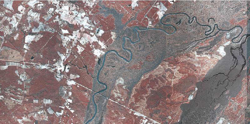
3 Woodbury WMA Marion County, March 28, 2015 (Meet at the Kiosk at 10:30) This month we will be exploring habitats at the Woodbury Wildlife Management Area. Woodbury is an over 25,000 acre finger of land bounded by the Great Pee Dee River to the west, the Little Pee Dee River to the east, and US 378 to the north. SCAN has visited here before and as mentioned earlier, this will not be an overnight trip as originally planned because Ark Lodge will not be available. However, I have been in touch with Francis Ervin and we are trying to schedule another weekend trip in either April or May. If we go in May we should see the Mcbridea blooming along the road to the Lodge. For those who have not been to Woodbury before, there are many habitats present including Carolina bays, wooded swamp, wet pine flatwoods, oxbow lakes, bottomland hardwoods, xeric pine habitat, depression wetlands, and of course, the rivers. Attached is a false-color infrared aerial photograph of Woodbury (courtesy of SCDNR). The dark signatures are wetland areas dominated by deciduous vegetation and red signifies evergreen vegetation. With a little practice you can learn to distinguish between upland pine forest and wetland areas dominated by evergreen vegetation such as gallberry, Lyonia, Gordonia, and pond pine. Two specific areas that we will be exploring on the 28 th are a depression wetland where we should see pondspice and pondberry blooming, and a xeric pine area located on a high ridge. We have visited this depression wetland before but it was during the fruiting season for the pondberry. I took a group from the Native Plant Society to the xeric pine area but SCAN has not been there before. Restroom facilities are not available and you will have to bring drinking water. We will be returning to our vehicles around lunch time so no need to pack food in to the wetland. SCDNR does a good job of maintaining the roads at Woodbury, however with all of the rain we ve gotten lately they may be a little rough so I recommend driving vehicles with decent ground clearance. Cell phone coverage is spotty, but if you get lost, give me a call at I haven t decided where we ll be having dinner so it will be a surprise.

4 DIRECTIONS TO WOODBURY From Marion (US 76/US 501 Business intersection): Take US 501 Business south for approximately 2.4 miles then turn right onto SC 41 ALT. Follow SC 41 ALT approximately 12.5 miles then turn left onto SC 908. Travel approximately 7.5 miles to the intersection of US 378/SC 908 and go straight across US 378 onto Old Neck Cemetery Road/Woodberry Road. Follow Woodberry Road approximately 5 miles to the Kiosk. From Lake City (US 378/US 52 intersection): Take US 378 east for approximately 28.3 miles and turn right onto Old Neck Cemetery Road/Woodberry Road at the US 378/SC 908 intersection. Follow Woodberry Road approximately 5 miles to the Kiosk. From Conway (US 378/US 501 Intersection): Take US 378 west approximately 16.5 miles and turn left onto Old Neck Cemetery Road/Woodberry Road at the US 378/SC 908 intersection. Follow Woodberry Road approximately 5 miles to the Kiosk. Woodberry Road/US 378 intersection coordinates are , Kiosk coordinates are ,

5 Woodbury WMA
March Hello everyone.
 March 2017 Hello everyone. For our first trip of 2017, we made a return trip to Woodbury WMA in Marion County. The weather was nice and we had a good turnout of members. Participants included Kim McManus,
Wetlands Reservoirs of Biodiversity. Billy McCord, SCDNR
 Wetlands Reservoirs of Biodiversity Billy McCord, SCDNR Estuaries Tidal Deepwater Intertidal Salt Marsh Tidal Riverine Fresh & Brackish Deepwater Tidal Emergent Marsh Freshwater Riverine Seasonally Flooded
KETTLE CREEK CONSERVATION AUTHORITY TRAIL GUIDE.
 KETTLE CREEK CONSERVATION AUTHORITY TRAIL GUIDE www.kettlecreekconservation.on.ca EXPLORE OUR TRAILS HIKE OUR TRAILS Kettle Creek Conservation Authority (KCCA) proudly supports and promotes an active lifestyle
Parks, Heritage Preserves, etc. and their SC Biogeographical Regions
 Parks, Heritage Preserves, etc. and their SC Biogeographical Regions Andrew Pickens Ranger District - Sumter National Forest Ashmore Heritage Preserve/Wildlife Management Area Bald Rock Heritage Preserve
Conservation Lands. Conservation Lands Advisory Committee October 19, 2005
 Conservation Lands Advisory Committee October 19, 2005 Roland DeBlois Chief of Environmental Planning & Code Enforcement Community Development Department Beth Powell Conservation Lands Manager Parks Division
The Croatan MST Segment 16B
 1 Mountains-to-Sea Trail Last Updated 1/1/2017 A sandy road through longleaf pine savanna in the Croatan National Forest Photo by PJ Wetzel, www.pjwetzel.com The Croatan MST Segment 16B STELLA TO THE NEUSIOK
BOOK 2. Discover Wayne County Trails. Trail Works, Inc. is a volunteer group dedicated to trail development and use.
 Trail Works, Inc. is a volunteer group dedicated to trail development and use. Your membership in Trail Works insures that healthy programs like this continue to thrive. Join today at www.trailworks.org
Asheville & WNC Hikes
 Asheville & WNC Hikes Amazingly, we have 3,000+ miles of free public hiking trails near Asheville, including 1,600 miles in the Pisgah and Nantahala National Forests, 850 miles in Great Smokey Mountains
A Day Trip to Silver Falls State Park and Silverton
 A Day Trip to Silver Falls State Park and Silverton One of my favorite Portland day trips is Salem area s Silver Falls State Park. Quite simply, this is a park I make a point to visit at least once a year.
Pinellas County Environmental Lands
 Pinellas County Environmental Lands In addition to traditional parks and recreation facilities, Pinellas County owns and manages a system of environmental lands that provides specialized resource-based
CELEBRATE WEST GREENWICH GEOCACHING THROUGHOUT WEST GREENWICH
 CELEBRATE WEST GREENWICH GEOCACHING THROUGHOUT WEST GREENWICH The West Greenwich Land Trust (WGLT) is sponsoring Celebrate West Greenwich, an event designed to celebrate the beauty and history of scenic
B HALL RANCH FISHTAIL, MONTANA
 Brochure Courtesy of: B HALL RANCH FISHTAIL, MONTANA w w w. m c c a s l i n l a n d. c o m Page 1 LOCATION The Hall Ranch is ideally located in the foothills of the Beartooth Mountains, approximately 5
IOWA ORNITHOLOGISTS' UNION - Birding Sites in Dallas County
 IOWA ORNITHOLOGISTS' UNION - Birding Sites in Dallas County Printed on 7/19/2018 Beaver Bottoms Wetland (restricted) (Important Bird Area) GPS Coordinates:, Ownership: Private (see directions for access)
Lava Mountain Trail Distance: Elevation Range: Trail Type: Difficulty: Season: Driving Distance: Driving Time: USGS Maps: Pros Cons
 Lava Mountain Trail Distance: 13.4 miles (including the side trip to North Star Lake) Elevation Range: 5900'-8330' Trail Type: singletrack Difficulty: moderate Season: late June-October Driving Distance:
Segment 2: La Crescent to Miller s Corner
 goal of the USFWS refuges is to conserve, protect and enhance fish, wildlife and plants and their habitats for the continuing benefit of the American people. Refuge lands are used largely for fishing,
This Passport: Revised October 20, 2017, EAM # Discovering the Trails of Penfield, NY
 This Passport: Revised October 20, 2017, EAM #161922 Discovering the Trails of Penfield, NY The Town of Penfield is fortunate to have a wide variety of natural resources which make for many unique and
F.O.K.O.S. Friends of Kingston Open Space A GUIDE TO KINGSTON OPEN SPACE
 F.O.K.O.S. Friends of Kingston Open Space A GUIDE TO KINGSTON OPEN SPACE Friends of Kingston Open Space (FOKOS) was formed when a handful of concerned citizens joined together to learn what could be done
corolla map 1 Corolla
 corolla map 1 Corolla Currituck Beach Lighthouse This unpainted 158-ft. brick lighthouse has been operating since December 1875. Visitors are invited to climb the 214 steps to the top for a panoramic view
The Neusiok Trail and Cedar Island MST Segment 17. THE NEUSIOK TRAIL TO CEDAR ISLAND FERRY By Kate Dixon and Jim Grode
 1 Mountains-to-Sea Trail Last Updated 1/1/2017 Hiking the Neusiok Trail Photo by Becka Walling The Neusiok Trail and Cedar Island MST Segment 17 THE NEUSIOK TRAIL TO CEDAR ISLAND FERRY By Kate Dixon and
Bratt ") 4. % F l o r i d a D e s i g n a t e d P a d d l i n g T r a i l s ") 164 «97 ") 99. Barrineau Park. M a p 1. M a p 2.
 4. % F l o r i d a D e s i g n a t e d P a d d l i n g T r a i l s ) 164 «97 ) 99. Barrineau Park. M a p 1. M a p 2.") F l o r i d a D e s i g n a t e d P a d d l i n g T r a i l s Bratt ") 4 Bluff Springs «4 Jay ") P e r d i d o R i v e r P e r d i d o CR R99A i v Walnut e r Hill ") 164 ") 97A «89 «97 ") 197 Barrineau
F l o r i d a D e s i g n a t e d P a d d l i n g T r a i l s Bratt ") 4 Bluff Springs «4 Jay ") P e r d i d o R i v e r P e r d i d o CR R99A i v Walnut e r Hill ") 164 ") 97A «89 «97 ") 197 Barrineau
General Highway System SHEET 1 HILTON HEAD ISLAND URBAN AREA
 5 6 7 8 A A B B General Highway System SHEET 1 HILTON HEAD ISLAND URBAN AREA SECONDARY ROUTE - - - - - 9 WETLAND OR MARSH - - - - - - - - - CHURCH AND CEMETERY - - - - - - - - CEMETERY - - - - - LM 78
Guide to. Suffolk. Walking. Trails. Lake Meade Park
 Walking Lake Meade Park Guide to Suffolk Trails Lake Meade Park Lonestar Lake Regional Park Walking Safety Tips Avoid walking alone on trails. Walking with friends is recommended. Tell someone where you
Cedar Run Wildlife Refuge s GO WILD Summer Camp Guide 2019
 Cedar Run Wildlife Refuge s GO WILD Summer Camp Guide 2019 Educate - Fascinate - Engage Dear Parent/Guardians, We re so excited you ve chosen to come to camp at Cedar Run this summer! There s so much to
Field Guide. Nature Nearby. Traverse City
 Field Guide Nature Nearby Traverse City FEATURED PROPERTIES 1 DEEPWATER POINT NATURAL AREA 2 HICKORY MEADOWS NATURAL AREA KALKASKA 3 MAPLE BAY NATURAL AREA E as t A rm G r a n d Tr a v er s e B ay 4 PELIZZARI
HEARTLINE. No. 2 Apr. Jun., 2012 Heartland Chapter, Florida Trail Association, Serving Polk, Hardee, Highlands and De Soto Counties
 HEARTLINE No. 2 Apr. Jun., 2012 Heartland Chapter, Florida Trail Association, Serving Polk, Hardee, Highlands and De Soto Counties FROM THE CHAIR: Well, it appears that winter has come and gone with little
Hatchet and Weogufka Creeks Treasures of Coosa County. Roger Vines County Extension Coordinator
 Hatchet and Weogufka Creeks Treasures of Coosa County Roger Vines County Extension Coordinator Overview Coosa County The Heart of Alabama Very rural county with an abundance of natural resources forestland,
BISMARCK, ARKANSAS
 BISMARCK, ARKANSAS WWW.DEGRAY.COM DeGray Lake Resort State Park is remote...within reach. It s conveniently located just one hour southwest of Little Rock and its national airport, and just six miles off
CRAZY HORSE TRAIL GUIDE
 CRAZY HORSE TRAIL GUIDE Abridged Version: July 2016 This is a short form of our interpretive trail guide for the Crazy Horse Trail. The full version of the guide has a more detailed description of the
Drive and Stop Routes
 Drive and Stop Routes Limantour Road 1 - easy and likely productive. From Bear Valley Visitor Center drive back out and turn left onto Bear Valley Rd. Turn left at Limantour Road (the first road). Drive
Little Grand Canyon near Pomona, Illinois
 Little Grand Canyon near Pomona, Illinois Below: View of the trail and the terrain created using the Map My Hike app Below: Summary of the hike created using the Map My Hike app Presented by: Jennifer
PRESIDENTIAL PONDERINGS
 PKWS June 2014 Issue Editor: Carol Mathis PRESIDENTIAL PONDERINGS We are just a few weeks away from the 2014 Charlotte Pond Tour. I still need one family to volunteer to help out at one pond where we do
Day 7 Grandfather Mountain
 Day 7 Grandfather Mountain MOTEL Grandfather Mountain. See exit for Highway 221. Motel is in Banner Elk on Highway 194. Linville Falls is a backup scenic area for us. Welcome to Day 7 Final Day of Our
Chapter 2: Summary of Existing Open Space System
 Chapter 2: Summary of Existing Open Space System In 1976, the Wake County Board of Commissioners established the Wake County Parks and Recreation Department in order to provide park facilities and programs
Children's Discovery Trail Guide - Lost Creek
 Children's Discovery Trail Guide - Lost Creek Thank you for spending time learning and observing some of the secrets of Red Rock Canyon Conservation Area has to offer. Feel free to talk to a ranger if
November 2016 Nature Film Series: Eyewitness Seashore from 10:00-11:00 a.m. Saturday, November 5th.
 November 2016 Nature Film Series: Eyewitness Seashore from 10:00-11:00 a.m. Saturday, November 5th. Ever wondered what happens to a crab that loses its claw? Find out how this animal and other creatures
IOWA ORNITHOLOGISTS' UNION - Birding Sites in Linn County
 IOWA ORNITHOLOGISTS' UNION - Birding Sites in Linn County Printed on 6/15/2018 Bever Park (ebird Hotspot) GPS Coordinates: 41.9851219,-91.6269125 Restrooms Parking Trails ADA Accessible Trails Boyson Trail
INFO FOR GROUP LEADERS
 INFO FOR GROUP LEADERS COMMUNICATE EARLY & OFTEN: Let us know ahead of time if your group size has changed or the ages within your group have changed. Also, let us know in advance if your group has any
IOWA ORNITHOLOGISTS' UNION - Birding Sites in Cerro Gordo County
 IOWA ORNITHOLOGISTS' UNION - Birding Sites in Cerro Gordo County Printed on 11/17/2018 Blue-wing Marsh GPS Coordinates: 43.0834956379463,-93.4430980682373 Pure natural area primarily used for hunting.
CAMP WINONA LETTERBOX TRAIL
 CAMP WINONA LETTERBOX TRAIL Welcome to the Camp Winona Letterbox Trail! This Letterbox Trail was created by Frederick Girl Scout Junior Troop 81213 for their Bronze Project. We hope you have as much fun
PASSPORT. Discovering the Trails of Webster, NY
 PASSPORT to family wellness Discovering the Trails of Webster, NY Join the Friends of Webster Trails, Webster Health and Education Network, The Town of Webster and Wegmans to get moving more and enjoy
The Palmetto Trail: Linking the Mountains to the Sea
 The Palmetto Trail: Linking the Mountains to the Sea Jana Locklair Pine Ridge Middle School jlock794@aol.com Overview Students will be given the opportunity to become familiar with the landform regions
Blue Ridge Hiking Club - First Quarter 2018 Hikes
 Blue Ridge Hiking Club - First Quarter 2018 Hikes Monday, Jan 1: Trout Lake to Manor House & Figure 8 Trail: Meet at Trout Lake parking lot, at 9:30. (1st exit left off Parkway just south of Cone Manor
SOUTH WALTON TRAILWAYS
 SOUTH WALTON TRAILWAYS 13 14 15 10 1 2 11 12 3 5 6 4 3 7 9 8 Nestled throughout Walton County are 200 miles of hiking and biking trails winding through state forests, state parks and public-private greenways.
Silver Lake Park An Environmental Jewel for the Citizens of Prince William County
 Silver Lake Park An Environmental Jewel for the Citizens of Prince William County The Prince William Park Authority Mission Statement states: The Prince William County Park Authority will create quality
Trailhead Ambassadors 2018 Latourell Falls: Alternative Hikes
 Trailhead Ambassadors 2018 Latourell Falls: Alternative Hikes General Note: The Historic Highway is closed from the Bridal Veil exit to its eastern end near Wyeth i.e., the Waterfall Alley section. The
Blue Ridge Hiking Club Hike List July- September 2016
 Blue Ridge Hiking Club Hike List July- September 2016 Saturday, July 2, Elk Knob: 3.8 mile round trip with 900 ft. gain in elevation. Spectacular views at the summit. The trails are mostly moderate, but
MCARTHUR SWAMP PLANNING UNIT Pit-McCloud River Watershed
 Existing Conditions & Uses Overview Spring-fed lake and rivers; valuable grazing lands and important waterfowl area Planning unit provides the only public access to Ahjumawi Lava Springs State Park 7,596
See Explorer Camp Brochure/ for Ages Ages 4-9
 www.tinmountain.org See Explorer Camp Brochure/ www.tinmountain.org for Ages 10-16 Ages 4-9 SUMMER CAMP 2011 CELEBRATING 27 YEARS OF SUMMER CAMP FOR CHILDREN AGES 4-16 YEARS Tin Mountain s mission is to
Nature is for everyone to enjoy, so let your followers experience the beauty.
 POCKET GUIDE WHILE YOU RE HIKING For your safety, please watch for loose rocks, tree roots, and other obstacles along the trails. Please park in designated parking areas only. Stay on the marked trail;
1. Title slide: Great Wagon Roads
 1. Title slide: Great Wagon Roads a. Going to discuss how our ancestors may have come to South Carolina b. Of course could have come aboard ship to Charleston c. Many came overland from the more northern
beach. Make the ford and follow the trail out to the junction with Red Creek Tr in an open grassy area.
 Description: This is a moderate to slightly strenuous 22.8 mile backpack (add 2.6 miles if you do the packless out and back to the Lion s Head) that will have you exploring nearly every thing that is The
Hike at Pico Blanco Labor Day Weekend!
 Hike at Pico Blanco Labor Day Weekend! The Pico Blanco Hymn Here among the trees majestic Pleasures you will find On the trails of Pico Blanco With your friends and mine Trail the Eagle ever onward This
TENNESSEE MOUNTAIN LIVING
 NOVEMBER 2016 Featuring Jasper Highlands TNLand.com END of the YEAR December 26th to Land Sale December 31st See back cover for more info... TENNESSEE MOUNTAIN LIVING JASPER HIGHLANDS - TENNESSEE'S MOST
WEST SECTION TRAIL SITES as of Mon October
 WEST SECTION TRAIL SITES as of Mon October 9 2017 Partial Site is open but some hiking trails/facilities may be closed Closed Site is closed until further notice Open Site is open Unknown We have no information
You must or mail an Individual Registration Form, Health Form, and Awanita Release Form for each camper, including chaperones.
 Thank you for registering for the Carolina Youth Camp at Awanita Valley Christian Retreat Center for 2018. We are so excited about what God has in store for this year s camp! You will find 2018 registration
AOTA ArtTrek Locations
 AOTA ArtTrek Locations ArtTrek is a summer-long Grand County, CO art adventure. Highlighted by snow-covered mountain vistas and rolling meadows threaded with sparkling streams and rivers, numerous sites
Brooker Creek Preserve Management Plan 2008 Update
 Brooker Creek Preserve Management Plan 2008 Update Plan approved by the Board of County Commissioners Pinellas County, Florida 19 August 2008 Pinellas County Department of Environmental Management Environmental
(/ 12 Æ% 127 Æ% 73 Æ% 22 Æ% 21 Æ% 13 Æ% 82 Æ% 23. Æÿ B. Æÿ V. Æÿ C. Æÿ FF. ÆÿCC. Æÿ JJ. Æÿ H. Æÿ Z. Æÿ G. Æÿ J. Æÿ ZZ. Æÿ D. Æÿ F.
 WAUSHARA ADAMS 4 Æÿ Z Existing Ice Age Trail, subject to change as it evolves toward completion Other Trail Unofficial Connecting Route (unmarked) County oundary ublic or IATA Land Miles 0 1 2 3 4 5 1
MONTGOMERY TOWNSHIP OPEN SPACE & PATHWAYS COMMITTEE
 MONTGOMERY TOWNSHIP OPEN SPACE & PATHWAYS COMMITTEE Meetings: 2 nd Wednesday of each month @ 6:30 PM in the Municipal Building Questions? Call the Open Space Coordinator, Lauren Wasilauski, at (908) 359-8211
Cataloochee. Fishing Species Rainbow Trout and Brook Trout. Recreation
 Cataloochee River Information The Cataloochee River is located in the historic Cataloochee Valley--a relatively remote part of Smoky Mountain National Park. The campground is a secluded setting and offers
Walking Tips. Locations. Good luck on your journey to better health! Earleigh Heights Ranger Station
 Walking Tips Dress in Layers The weather and even your own body temperature can fluctuate as you walk or hike. Layering allows you to comfortably add or remove clothing as needed during your activity.
Forever Wild Program Acquisitions CURRENT AS OF 1/4/2017
 Forever Wild Program Acquisitions CURRENT AS OF 1/4/2017 1. THE MONSANTO TRACT in Marshall County consists of 209 acres of donated mountainous, pine-hardwood covered peninsula on Lake Guntersville that
JACKSON HOLE, WYOMING
 Click below to navigate our services E X C I T I N G A C T I V I T I E S U N I Q U E V E N U E S P R I V A T E D I N I N G I N S P I R I N G D É C O R E N T E R T A I N M E N T L O G I S T I C S Local
Forever Wild Program Acquisitions (Tract Values at Time of Purchase) CURRENT AS OF 1/28/2019
 CURRENT AS OF 1/28/2019") Forever Wild Program Acquisitions (Tract Values at Time of Purchase) CURRENT AS OF 1/28/2019 1. MONSANTO TRACT in Marshall County consists of 209 acres of donated mountainous, pine-hardwood covered peninsula
Forever Wild Program Acquisitions (Tract Values at Time of Purchase) CURRENT AS OF 1/28/2019 1. MONSANTO TRACT in Marshall County consists of 209 acres of donated mountainous, pine-hardwood covered peninsula
Hiking in Connestee Falls
 Hiking in Connestee Falls Connestee Falls Property Owners Association, Inc. 33 Connestee Trail, Brevard, NC 28712 828-885-2001, email cfpoa@citcom.net www.connesteefalls.com 1 Few private communities,
(/ 63 (/ 8 Æ% 48 Æ% 87 Æ% 35 Æ% 35 Æ% 65 Æ% 46. Æÿ J. Æÿ W. Æÿ I. Æÿ E. Æÿ O. Ice Age Trail Polk and Burnett Counties MINNESOTA
 ce Age Trail olk and Burnett Counties olk and Burnett Counties ce Age Trail Alliance www.iceagetrail.org Frederic Trade Æÿ McKenzie Creek ildlife Area Æÿ O Æÿ E Æÿ Æÿ O ndian Creek McKenzie Creek BURNETT
Sandy Ridge Information Packet For Outside Groups
 2017-2018 Sandy Ridge Information Packet For Outside Groups Girl Scouts of Eastern South Carolina History of Sandy Ridge Girl Scout Program and Training Center 1963 Site was decided 1963 1965 Purchased
CAMP ROCK RANCH JACK KAVANAUGH RMABROKERS.COM
 CAMP ROCK RANCH JACK KAVANAUGH 303.909.1706 JACK@RMABROKERS.COM RMABROKERS.COM CAMP ROCK RANCH COLORADO - CLEAR CREEK COUNTY - UPPER BEAR CREEK ROAD, EVERGREEN The 162±-acre Camp Rock Ranch is surprisingly
$850,000 Awarded to 20 Organizations
 $850,000 Awarded to 20 Organizations The Conservation Alliance is pleased to fund the following organizations to support their efforts to protect wild lands and waterways for their habitat and recreation
Cuyahoga Valley National Park Ohio
 Cuyahoga Valley National Park Ohio Brandywine Falls The Ledges The Beaver Marsh Temperate Deciduous Forest How To Get There... Located between Cleveland & Akron, Ohio Cuyahoga Valley National Park can
THE HRT IN SAXAPAHAW NEW TRAIL, NEW PARK
 Summer 2016 What is the Haw River Trail Partnership? The Haw River Trail Partnership was formed with the goal of helping the public enjoy and conserve the natural resources of the Haw River corridor. The
Non-motorized Trail Plan & Proposal. August 8, 2014
 Town of Star Valley Ranch, Wyoming and the Star Valley Ranch Association in partnership with the USDA Forest Service, Bridger-Teton National Forest, Greys River Ranger District Non-motorized Trail Plan
Æÿ U Æ% Sauk Point @ Segment Merrimac. Æÿ DL. Devil's Lake. State Park. Gibraltar.
 MARQUETTE Æ% 23 French Creek Wildlife Area Dells Æ% 127 Æÿ H Æÿ F (/ 51 Lake Delton Æÿ Æ% 16 90 Mirror Lake State ark Western Bifurcation Æ% 23 ortage ortage Canal 94 ine Island Wildlife Area Eastern Bifurcation
4988 +/- ACRES JEFFERSON AND LEON COUNTY, FLORIDA
 4988 +/- ACRES JEFFERSON AND LEON COUNTY, FLORIDA Located in the famed Red Hills of north Florida, El Destino Plantation consists of 4988+/- acres and represents an incredible opportunity to own one of
Education Programs Duck Mountain Provincial Park
 Education Programs Duck Mountain Provincial Park 2018 Programs Bring your class to our outdoor classroom! Guided school programs are offered during the spring in Duck Mountain Provincial Park. Booking:
Directions to Gathering/other Events:
 Directions to Gathering/other Events: Scroll down the list below (churches are in alphabetical order)!! Andrews Chapel UMC: From Conway: From Conway: Take 501 to Highway 31 North. Take the Highway 9 exit
CREW Cypress Dome Trails Self-Guided Tour
 CREW Cypress Dome Trails Self-Guided Tour The numbers in this guide correspond to numbers on the Cypress Dome Trail Map (included in this guide below) and to the brown number plates fastened to marker
The gorges of Mohican Park in Ohio create a hiker's paradise Sunday, May 22, 2011 By Bob Downing, Akron Beacon Journal
 Pittsburgh Post-Gazette The gorges of Mohican Park in Ohio create a hiker's paradise Sunday, May 22, 2011 By Bob Downing, Akron Beacon Journal Bob Downing Big Lyons Falls drops 80 feet into a shady U-shaped
Bankhead Lake TWO PARCELS AND 1 LOT FOR SALE
 OVERVIEW NORTH PARCEL ACRES: 46 WATERFRONT: 1,227 Front Feet PRICE: $350,000 PER ACRE: $7574 PER FRONT FT. $285 SOUTH PARCEL ACRES: 22 WATERFRONT: 1,381 Front Feet PRICE: $295,000 PER ACRE: $13,170 PER
ABOUT THE PARKS NANTAHALA NATIONAL FOREST MOUNTAINS NATIONAL PARK CHEROKEE NATIONAL FOREST PISGAH NATIONAL FOREST GREAT SMOKY HIKING TRAILS
 ABOUT THE PARKS GREAT SMOKY MOUNTAINS NATIONAL PARK NANTAHALA NATIONAL FOREST CHEROKEE NATIONAL FOREST PISGAH NATIONAL FOREST GREAT SMOKY MOUNTAINS NATIONAL PARK Straddling the border between North Carolina
Weston County, Wyoming
 The Sweet 200-Acre Property Weston County, Wyoming A unique opportunity to own a little piece of the old West, where one can experience unparalleled scenery, adventure and history walk in the footsteps
OTZINACHSON REGIONAL GROUP OF THE SIERRA CLUB Edward Abbey Hiking Society Spring- Summer 2013 Outings Schedule
 For more information contact: Paul Shaw, Outings Chair 155 Mowery Lane Sunbury PA 17801 717-215- 8339 pshaw@ptd.net Saturday, March 23: Switchback Railroad, Carbon County 11 miles, moderate to strenuous.
Glacier National Park, MT
 Glacier National Park, MT July 28 Aug. 1, 2010 We decided to go to Glacier National Park for our family vacation this year. We had a great time seeing beautiful scenery and a variety of wildlife which
Best Places to Explore in NC High Country
 Best Places to Explore in NC High Country Caroline McGuire cmcguire@brri.net (828)773-7276 cell (828)263-8711 ext 240 Tweetsie Railroad-a family friendly Wild West theme park located on Highway 321S between
Staunton River Trail to Hoover Camp and Fork Mtn. Relay Tower (Based on September 18, 2013 hike by Ron Singleton, Fredericksburg, Va.
 Staunton River Trail to Hoover Camp and Fork Mtn. Relay Tower (Based on September 18, 2013 hike by Ron Singleton, Fredericksburg, Va.) The President's Cabin (The "Brown" House) at Camp Hoover. Sign on
Hiking Trail Descriptions
 Hiking Trail Descriptions For ye shall go out with joy. And be led forth with peace. The mountains and the hills shall break forth before you in singing. And all the trees of the fields shall clap their
ASRA 2018 Hike Schedule
 ASRA 2018 Hike Schedule Date/Day Destination Hike Info Meeting Info Leader Feb 10, Saturday Stagecoach and 9:00 at the Confluence kiosk. Manzanita trails Parking fee required. We ll hike along the trail
A Publication of Friends of Sleeping Bear Dunes
 A Publication of Friends of Sleeping Bear Dunes 2014, Friends of Sleeping Bear Dunes, P.O. Box 545, Empire, MI 49630 www.friendsofsleepingbear.org info@friendsofsleepingbear.org Learn more about the Friends
Mountain Shag Club. Asheville, NC. May 2012 Newsletter mountainshagclub.com. Association of Carolina Shag Clubs
 Mountain Shag May 2012 Newsletter mountainshagclub.com Association of Carolina Shag s Member since 1989 1 Mc Mcllvoy 5/07 Dotty Lamb 5/09 Linda Lewis 5/24 Letter from the President Hello Shaggers, Oh yes,
Climbing Oak and Brushy Top Mountains
 Climbing Oak and Brushy Top Mountains Story and photographs by Vann Helms www.blueridgeimpressions.org Brushy Top Mountain- February 2, 2014 Brushy top summit After a January of record breaking cold weather,
W E L C OM E TO BAC K Y AR D N AT U R E C E N TER S SITE R E SOURCE PAC K E T S!
 LITTLE HOUSE OF GLENCOE Last updated September 7, 2011 W E L C OM E TO BAC K Y AR D N AT U R E C E N TER S SITE R E SOURCE PAC K E T S! BackYard Nature Center (BYNC) has selected and described six nature
Colorado Life Zone Scavenger Hunt
 Colorado Life Zone Scavenger Hunt Below are worksheets created for all the habitats or life zones. They were designed with the intention of breaking the class up into small groups, and having students
Below is the section of the Byway discussed in the Tazewell County meeting. Primary coal sites are noted on the map.
 APPENDIX H: PUBLIC PARTICIPATION SERIES OF TOWN MEETINGS Virginia Coal Heritage Trail Corridor Management Plan Meeting in Richlands on the Tazewell County portion of the Pocahontas Trail September 21 st
A North Carlina Pet Getaway in Lake Lure and the Blue Ridge Foothills
 A North Carlina Pet Getaway in Lake Lure and the Blue Ridge Foothills Explore our quaint downtowns and enjoy the friendly faces and wagging tails that will welcome you to Lake Lure and the Blue Ridge Foothills.
Conservation Area Management Statement
 Conservation Area Management Statement Miller Creek Wildlife Area Resolution #: Approval: Issue Date: Date of Last Revision: Table of Contents 1. Purpose....... 1 2. Property Description...... 1 2.1. Legal
2014 Spoon Gathering June 6 & 7 Information Package
 1 2014 Spoon Gathering June 6 & 7 Information Package Mission statement. Sharing the knowledge of carving spoons and related handcrafts, while creating an inclusive gathering for all. History of the Gathering
Comanche National Grassland, Timpas Unit
 Comanche National Grassland, Timpas Unit Heritage Resources More than 540 sites are eligible for listing on the National Register of Historic Places (NRHP) by Forest Service staff and/or the Colorado State
Frond Forum Florida Native Plant Society Cuplet Fern Chapter :: Seminole County
 Florida Native Plant Society Cuplet Fern Chapter :: Seminole County 2013 14 Board President: Beth Jackson Vice President: Sherry Williams Secretary: Christine Brown Treasurer: Susan Blount-Angermeier Chapter
Region 1 Piney Woods
 Region 1 Piney Woods Piney Woods 1. This ecoregion is found in East Texas. 2. Climate: average annual rainfall of 36 to 50 inches is fairly uniformly distributed throughout the year, and humidity and temperatures
Beaver Creek State Park
 GENERAL INFORMATION Name of Park/Forest/Facility: Beaver Creek State Park County: Columbiana (St. Clair Township) Address: 12816 Sprucevale Road (ie County Rd 428) (street #, city) East Liverpool, Ohio