Hatchet and Weogufka Creeks Treasures of Coosa County. Roger Vines County Extension Coordinator
|
|
|
- Lucy Holmes
- 5 years ago
- Views:
Transcription

1 Hatchet and Weogufka Creeks Treasures of Coosa County Roger Vines County Extension Coordinator


2 Overview Coosa County The Heart of Alabama Very rural county with an abundance of natural resources forestland, pastures, ponds, lakes, streams, wildlife and fish Bordered by the Coosa River on the west and the Tallapoosa River on the east The county has two large streams, Hatchet and Weogufka Creeks that are popular floating trips.

3 Weogufka and Hatchet Creeks Weogufka Creek Hatchet Creek Coosa County, Alabama

4 Coosa Creeks Map and Visitor Guide Project funded by a grant from the Coosa Valley R.C.& D Council Purpose: To develop a map that will highlight the floating opportunities on Hatchet and Weogukfa Creeks in Coosa County Goal: Develop a map to include a variety of topics and information : GPS locations of all launch sites Photos of unique features Public campsites Description of plants and animals Historical information Estimated travel time & distances Other general tips and contacts

5 The Expedition Crew Roger Vines Chuck Browne David Kelley Shane Harris

6 Creeks Designated as a Spur of the Alabama Scenic River Trail President, Fred Couch The ASRT is a 631 mile float trail from the Alabama/Georgia line in Cherokee County down the Coosa River to the Gulf of Mexico

 Water level can be low by late spring/early")
7 Weogufka Creek Weogufka is a Native American word for Muddy Water Upper end flows through forest and farm land and the lower end is completely wild as it enters the Coosa Wildlife Management Area There are six float sections that are 4 or 5 hours each to float at a casual pace (one section is a short 1 hour) Water level can be low by late spring/early summer
 One mile south of")
8 County Road 112 (Launch #1) One mile south of Weogufka

9 South Weogufka (Launch #2) Co. Rd. 29 Two miles south of Weogufka Access is difficult on this section Landowner may grant access to a better launch site on back side of pasture by permission only This section is likely to have some downed logs and portages With moderate water flow the float takes about five hours

10 Expect a Couple Log Jams

11 Low Water Bridge North of Mt. Moriah on Co Rd 16 Loop Water Levels need to be just right! You can limbo under the bridge, if the water is not too high If the water is too low you will do a lot of dragging Better too high you can always portage around the bridge

12 First Underwater Bridge Small cement ford on private property

13 Mt. Moriah (Launch #3) Co. Rd 15 NW of Mt. Moriah Church There is an easy launch site on the west side of the bridge and nice spot to park a vehicle

14 Second Low Water Bridge Washed out below launch #3

15 Shoe Makers Cave (Launch #4) In the Coosa Wildlife Management Area

16 Underwater Bridge Launch #5 5 miles west of Coosa WMA Checking Station


17 Hatchet Creek One of the best float creeks in Alabama Hatchet comes from a Native American word Hatchee that means upon the water The creek has five or six main sections to float depending how you split it up The creek begins north of Goodwater and flows southwest across the county until it flows into the Coosa River (Mitchell Lake)

18 The Headwaters of Hatchet Hatchet originates in Clay County and flows down to Goodwater This section is often too shallow to float The Goodwater Train Trestle is on this stretch and is an amazing structure The original trestle was built back in 1887 and was made of wood It was destroyed by fire and a new steel trestle was constructed in it s place and is still used today


19 Hatchet Creek (Launch #1) Hwy 511 Goodwater The first part of this section is slow moving water as it leads to the only existing dam on Hatchet Creek.


20 Goodwater Dam Portage The best portage is on the right side of the creek along an old roadbed and trail.


21 Goodwater Golf Course (Launch #2) Co. Rd. 66 east of Mt. Olive Rock pile on left makes a good lunch break site when floating from Co. Rd. 511 to Hwy 280 For a short float you can put in here and float down to Hwy 280 (about a 2 ½ to 3 hour float)

22 Hwy 280 Launch #3 Easy launch site with good parking


23 Old Grist Mill Campsite Free Public Camping Property of Norman Ray One hour below Hwy 280 N W

24 Dunnam s Flat Rock Lunch Stop N W
25 Dunnam s Halfway Campsite Public Camping on property of Tommy and Beverly Bass about 4 hours below Hwy 280 Located halfway between Hwy 280 and Hwy 231 which is the longest stretch of the creek between take outs.

26 Mermaid Rock N 32 degrees 59 minutes seconds W 86 degrees 08 minutes seconds

27 Big Bend Shoals N 32 degrees 58 minutes seconds W 86 degrees 09 minutes seconds

28 Hwy 231 (Launch #4) Four miles North of Rockford Very popular launch site with easy access to the creek and good parking


29 Hwy 231 Creek Gauge If big rock is covered, expect an exciting float If little rock is exposed, plan for some dragging If little rock covered but still see top of big rock then water levels are just right, about 300 CFM

30 Hwy 231 Dam Hatchet Creek has the distinction of being one of the first creeks in Alabama to ever be impounded to generate electric power. This dam was built to provide electricity to the city of Sylacauga.


31 Old 231 Dam Campsite Short distance below Hwy 231 Public Camping on the property of Sally Holland N W


32 Privet Cove Campsite One hour below Hwy 231 N W Public Camping on the property of David and Loraine Kelley

33 Boulder Island N 32 degrees 56 minutes 28 seconds W 86 degrees 13 minutes 26 seconds

34 Cahaba Lilies Shoal This is the only shoal of Cahaba Lilies on this section of Hatchet Creek between Hwy 231 and Kings Bridge. The shoal is about ¼ mile long, wide, shallow and strewn with large rocks. Plan to do some dragging even with a kayak. The Cahaba Lilies bloom from mid May to mid June. No attempt should be made to transplant the lilies, they are very specific to areas where they can grow.

35 Cool Creek Enters Hatchet This beautiful little creek had really cold water and enters on the left side above Kings Bridge

36 King s Bridge Co Rd 18 Take out is on the right just before the bridge

37 Double Bridges Co Rd 29 North of Kelley s Crossroads Water becomes slow deep and wide at this point as the creek enters Mitchell Lake There is only one bridge the name comes from when there was once a bridge over Swamp Creek


38 A Chance to See Something Rare Bald Eagle Eastern Coral Snake Cahaba Lily


39 Threatened or Endangered Species Toulatoma Snails Red Cockaded Woodpecker


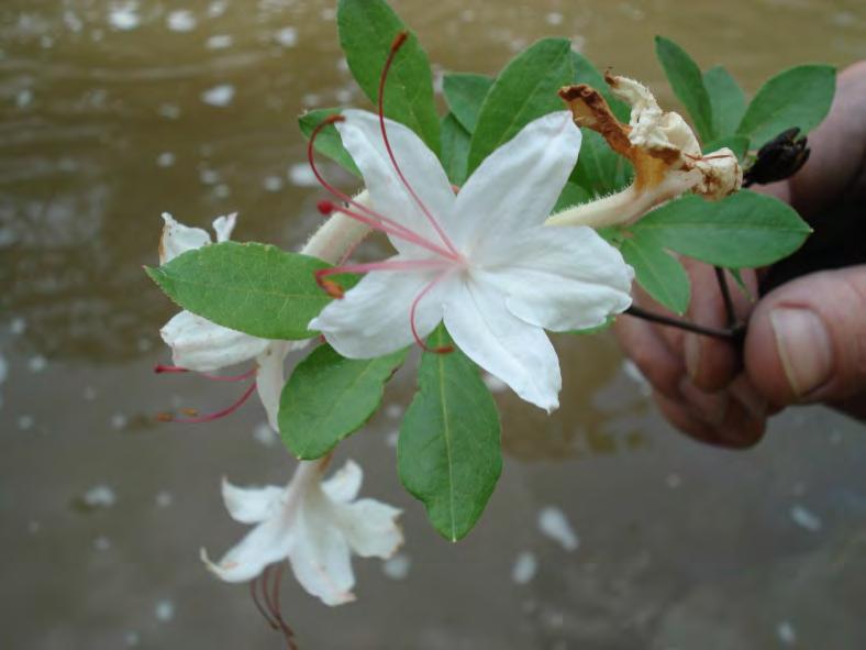
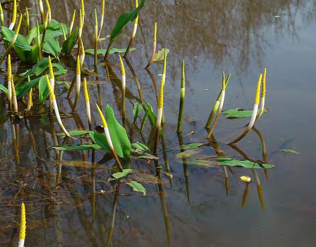
40 Beautiful Flowers Mountain Laurel Rhododendron Sweet Azalea Goldenclub


41 Riparian Trees Southern Catalpa Bigleaf Magnolia


42 Interesting Fish and Wildlife Turtle Laying Her Eggs Great Blue Heron Rookery Alligator Gar


43 Historical Sites Goodwater Train Trestle Sylacauga Power Plant Goodwater Power Plant Old Grist Mill Foundation


44 The final product is a map with Weogufka Creek on one side and Hatchet Creek on the other. The maps were printed on semiwater proof paper.

45 Photographs were collected at various points of interest and then printed on the maps with the GPS coordinates. The photos were also posted to Google Earth This is a photo of Shoemakers Cave believed to have been used during the Civil War to make shoes for soldiers.


46 Rack cards were designed and printed. These cards will be distributed at all the State Visitor Centers. The purpose of the card is to arouse interest, while the maps themselves are distributed through the County Extension Office.

47 A full size stand up display was developed to be used for promotion of the project at various workshops, festivals, exhibits, fairs and other locations. The project and maps have also been promoted on television and radio. We have plans to host a Hatchet Creek Festival next spring to include an overnight campout float, speakers and live music.


48 A Project of the Alabama Cooperative Extension System, Coosa County Office And the Coosa Valley R.C.& D Council
Leverage: something out of nothing! Eighteen percent of water in America that flows into an ocean flows through Alabama.! Alabamaencyclopedia.org!
 Leverage: something out of nothing! Eighteen percent of water in America that flows into an ocean flows through Alabama.! Alabamaencyclopedia.org! What it is! Over a thousand miles with sprawling flatwater,
On The Trail. Twelve Mile Run and Kunes Camp Trail ---splendid solitude! By Gary Thornbloom
 On The Trail Twelve Mile Run and Kunes Camp Trail ---splendid solitude! By Gary Thornbloom Twelve Mile Run is about as isolated as you can get in the Quehanna Wild Area. You will find solitude and silence
Asheville & WNC Hikes
 Asheville & WNC Hikes Amazingly, we have 3,000+ miles of free public hiking trails near Asheville, including 1,600 miles in the Pisgah and Nantahala National Forests, 850 miles in Great Smokey Mountains
KETTLE CREEK CONSERVATION AUTHORITY TRAIL GUIDE.
 KETTLE CREEK CONSERVATION AUTHORITY TRAIL GUIDE www.kettlecreekconservation.on.ca EXPLORE OUR TRAILS HIKE OUR TRAILS Kettle Creek Conservation Authority (KCCA) proudly supports and promotes an active lifestyle
Mills Pecos River Ranch 7800 Acres Val Verde County, Texas Situated along both sides of the Pecos River
 Mills Pecos River Ranch 7800 Acres Val Verde County, Texas Situated along both sides of the Pecos River James King, Agent Office 432-426-2024 Cell 432-386-2821 James@KingLandWater.com King Land & Water
JACKSON LAKE LODGE 2011 Group Activities
 Snake River Wild & Scenic Rafting Trips All rafting trips depart from the lower lobby of Jackson Lake Lodge. Wild & Scenic Rafting Trip (approx. 3 hours) Adult $56 Child $35 (6-11) Enjoy a 10-mile raft
Camping (Primitive) Camping (RV) Electrical Potable Water Grill Established Fire Pit Picnic Table
 Camping (RV) Electrical Potable Water Grill Established Fire Pit Picnic Table") Alden - 9th Road River Mile 777 Map: 38.20833, -98.32031 Managing Agency: Kansas Department of Wildlife, Parks & Tourism Nearest Community: Alden, Rice County Kansas Developed Amenities Provided Parking
Alden - 9th Road River Mile 777 Map: 38.20833, -98.32031 Managing Agency: Kansas Department of Wildlife, Parks & Tourism Nearest Community: Alden, Rice County Kansas Developed Amenities Provided Parking
Wetlands Reservoirs of Biodiversity. Billy McCord, SCDNR
 Wetlands Reservoirs of Biodiversity Billy McCord, SCDNR Estuaries Tidal Deepwater Intertidal Salt Marsh Tidal Riverine Fresh & Brackish Deepwater Tidal Emergent Marsh Freshwater Riverine Seasonally Flooded
Bat Cave Canyon Ranch 2,920 acres Jeff Davis County, Texas
 Bat Cave Canyon Ranch 2,920 acres Jeff Davis County, Texas James King, Agent Office 432.426.2024 Cell 432.386.2821 James@KingLandWater.com Bat Cave Canyon Ranch 2,920 acres Jeff Davis County, Texas James
Guide to Your Adventure Walk
 Guide to Your Adventure Walk 7 Are you ready to search for some Michigan plants and animals? Grab your backpack, or borrow one from the garden store, and let s get started! On this hike you will see many
Blue Ridge Hiking Club - First Quarter 2018 Hikes
 Blue Ridge Hiking Club - First Quarter 2018 Hikes Monday, Jan 1: Trout Lake to Manor House & Figure 8 Trail: Meet at Trout Lake parking lot, at 9:30. (1st exit left off Parkway just south of Cone Manor
Bratt ") 4. % F l o r i d a D e s i g n a t e d P a d d l i n g T r a i l s ") 164 «97 ") 99. Barrineau Park. M a p 1. M a p 2.
 4. % F l o r i d a D e s i g n a t e d P a d d l i n g T r a i l s ) 164 «97 ) 99. Barrineau Park. M a p 1. M a p 2.") F l o r i d a D e s i g n a t e d P a d d l i n g T r a i l s Bratt ") 4 Bluff Springs «4 Jay ") P e r d i d o R i v e r P e r d i d o CR R99A i v Walnut e r Hill ") 164 ") 97A «89 «97 ") 197 Barrineau
F l o r i d a D e s i g n a t e d P a d d l i n g T r a i l s Bratt ") 4 Bluff Springs «4 Jay ") P e r d i d o R i v e r P e r d i d o CR R99A i v Walnut e r Hill ") 164 ") 97A «89 «97 ") 197 Barrineau
ABOUT THE PARKS NANTAHALA NATIONAL FOREST MOUNTAINS NATIONAL PARK CHEROKEE NATIONAL FOREST PISGAH NATIONAL FOREST GREAT SMOKY HIKING TRAILS
 ABOUT THE PARKS GREAT SMOKY MOUNTAINS NATIONAL PARK NANTAHALA NATIONAL FOREST CHEROKEE NATIONAL FOREST PISGAH NATIONAL FOREST GREAT SMOKY MOUNTAINS NATIONAL PARK Straddling the border between North Carolina
KEY. Physical Activity Levels. Low = Medium = Creative = High = Accommodation Types. = Camping (Tents) = Hard Top
 = Hard Top") Program Calendar July December 2018 KEY Physical Activity Levels Low = Medium = High = Creative = Accommodation Types = Camping (Tents) = Hard Top JULY Tuesday 5 Yarra River Walk - Ideal for new participants
Program Calendar July December 2018 KEY Physical Activity Levels Low = Medium = High = Creative = Accommodation Types = Camping (Tents) = Hard Top JULY Tuesday 5 Yarra River Walk - Ideal for new participants
Region 7 Western Panhandle Apalachicola River to Deer Lake Junction
 Region 7 Western Panhandle Apalachicola River to Deer Lake Junction Description Dist S-N Wypt N-S Cross Apalachicola River on SR 20 bridge. 1.5 0.0 8-2 175.4 Eastern/Central Time Zone change. Pass restaurant
Description Dist S-N Wypt N-S Region 7 Western Panhandle Apalachicola River to Deer Lake Junction
 Region 7 Western Panhandle Apalachicola River to Deer Lake Junction Description Dist S-N Wypt N-S Cross Apalachicola River on SR 20 bridge. 1.5 0.0 8-2 175.4 Eastern/Central Time Zone change. Pass restaurant
Climbing Oak and Brushy Top Mountains
 Climbing Oak and Brushy Top Mountains Story and photographs by Vann Helms www.blueridgeimpressions.org Brushy Top Mountain- February 2, 2014 Brushy top summit After a January of record breaking cold weather,
Forever Wild Program Acquisitions CURRENT AS OF 1/4/2017
 Forever Wild Program Acquisitions CURRENT AS OF 1/4/2017 1. THE MONSANTO TRACT in Marshall County consists of 209 acres of donated mountainous, pine-hardwood covered peninsula on Lake Guntersville that
2019 Work Week Crew. Schedule and Descriptions
 2019 Work Week Crew WAWONA WW1 Mariposa Grove Restoration and Invasive Plant Removal June 2 June 8 YOSEMITE VALLEY YV1 Washington Column Climber s Trail Rehabilitation June 9 June 15 YV2 Weed Warriors/
ASRA 2018 Hike Schedule
 ASRA 2018 Hike Schedule Date/Day Destination Hike Info Meeting Info Leader Feb 10, Saturday Stagecoach and 9:00 at the Confluence kiosk. Manzanita trails Parking fee required. We ll hike along the trail
MAIN LAKE PROVINCIAL PARK
 MAIN LAKE PROVINCIAL PARK PURPOSE STATEMENT AND ZONING PLAN March 2003 MAIN LAKE PROVINCIAL PARK Purpose Statement and Zoning Plan Primary Role The primary role of Main Lake Park is to protect a biologically
Charnley Explorer June 24 - July 15, 2018 Bachsten Creek and the Charnley River. Second draft: 14 November 2017
 Charnley Explorer June 24 - July 15, 2018 Bachsten Creek and the Charnley River. Second draft: 14 November 2017 The best part of the original section one is now part of out Gibb Road Gorges trip. The dates
The Florida Wildlife Corridor: Archbold Biological Station important partner in science and conservation
 To: Highlands News-Sun From: Archbold Biological Station Published: May 4, 2018 Author: Archbold Biological Station The Florida Wildlife Corridor: Archbold Biological Station important partner in science
$850,000 Awarded to 20 Organizations
 $850,000 Awarded to 20 Organizations The Conservation Alliance is pleased to fund the following organizations to support their efforts to protect wild lands and waterways for their habitat and recreation
WEST SECTION TRAIL SITES as of Mon October
 WEST SECTION TRAIL SITES as of Mon October 9 2017 Partial Site is open but some hiking trails/facilities may be closed Closed Site is closed until further notice Open Site is open Unknown We have no information
Androscoggin River Trail Access Sites. North Woods. 168 miles from its source at Lake Umbagog to Merrymeeting Bay
 Androscoggin River Trail Access Sites North Woods 168 miles from its source at Lake Umbagog to Merrymeeting Bay Trail Under Construction More than 40 Public Access Sites Available Androscoggin River Watershed
Caledon Hills Bruce Trail Club Discovery Hike Series Badge
 Caledon Hills Bruce Trail Club Discovery Hike Series Badge To earn this Discovery Badge you must complete all the hikes listed below, either on your own or on an organized hike. You will have fun discovering
TENKILLER STATE PARK -An Overview-
 TENKILLER STATE PARK -An Overview- - 0 - TENKILLER STATE PARK Region: Northeast (Green Country) Cherokee & Sequoyah Counties CONTENTS General Information. 2 Addresses Driving Directions Phone Numbers Email
The View at Bankhead Lake 12 miles off new Interstate Corridor X
 The View at Bankhead Lake 12 miles off new Interstate Corridor X offers the opportunity to the first to view 6 beautiful waterfront lots on Bankhead Lake to be released Saturday August 25th. Appointment
Forever Wild Program Acquisitions (Tract Values at Time of Purchase) CURRENT AS OF 1/28/2019
 CURRENT AS OF 1/28/2019") Forever Wild Program Acquisitions (Tract Values at Time of Purchase) CURRENT AS OF 1/28/2019 1. MONSANTO TRACT in Marshall County consists of 209 acres of donated mountainous, pine-hardwood covered peninsula
Forever Wild Program Acquisitions (Tract Values at Time of Purchase) CURRENT AS OF 1/28/2019 1. MONSANTO TRACT in Marshall County consists of 209 acres of donated mountainous, pine-hardwood covered peninsula
LOCAL PLAN FOR THE MANAGEMENT OF THE APPALACHIAN TRAIL IN MAINE. (GRAFTON NOTCH TO KATAHDIN) 1 January 2013 (Revised 5 February 2014)
 1 January 2013 (Revised 5 February 2014)") LOCAL PLAN FOR THE MANAGEMENT OF THE APPALACHIAN TRAIL IN MAINE (GRAFTON NOTCH TO KATAHDIN) 1 January 2013 (Revised 5 February 2014) The Appalachian Trail is a way, continuous from Katahdin in Maine to
LOCAL PLAN FOR THE MANAGEMENT OF THE APPALACHIAN TRAIL IN MAINE (GRAFTON NOTCH TO KATAHDIN) 1 January 2013 (Revised 5 February 2014) The Appalachian Trail is a way, continuous from Katahdin in Maine to
NORTH GEORGIA MOUNTAINS, USA. Knights Mill Farm
 NORTH GEORGIA MOUNTAINS, USA Knights Mill Farm Knights Mill Farm NORTH GEORGIA MOUNTAINS, USA Introduction: This historically significant property is perfect for development into a family compound with
Trip Dossier. 11 Day Kimberley Coast Cruise Darwin -Broome. 31 May - 10 June June - 1 July 2019
 Trip Dossier Darwin -Broome 31 May - 10 June 2019 21 June - 1 July 2019 Highlights: Zodiac cruise breathtaking Horizontal Waterfalls, Wandjina/ Gwion Gwion rock paintings, Lacepede Islands impressive seabird
Allegheny Mountain Cluster
 Allegheny Mountain Cluster Laurel Fork Paddy Lick West Back Creek Mountain The Allegheny Mountain Cluster lies on the backbone of Virginia. Its components are located in the James River and Warm Springs
Delaware Wildlife Area
 Delaware Wildlife Area 8 miles away from Delaware 4,670 acre Wildlife Area 1) Take Rt. 36/East Williams Street eastward 2) Take left onto Rt. 42/Lake Street 3) Slight left onto Horseshoe Rd./CR. 220 4)
Pinellas County Environmental Lands
 Pinellas County Environmental Lands In addition to traditional parks and recreation facilities, Pinellas County owns and manages a system of environmental lands that provides specialized resource-based
ROAD SCHOLAR SPRING HIKING ADVENTURE Tentative Schedule April 8-13, 2018
 Sunday, April 8 ROAD SCHOLAR SPRING HIKING ADVENTURE Tentative Schedule April 8-13, 2018 PM 3:00-5:00 Arrival, registration and move in to the dorm. 6:00 Supper EVE 7:00 Welcome & Orientation, Sign Ups
Covenant Health presents
 Covenant Health presents www.covenanthealth.com 1. 2. 3. 4. 5. 6. 7. 8. 9. 10. 11. Trail Guidelines Wear proper hiking shoes. Please be on time. Make sure that you understand & have signed the waiver.
Niagara Natural Heritage Park
 A Future Proposal For the Niagara-on-the-Lake DND Lands....... Parks Canada Lakeshore Road Property 1 May, 2016 The Harmony Residents Group We are proposing a Natural Heritage Park be established on the
Maya s Creek Crossing Hwy 17 N acres $185,000 Fort Davis, Texas
 Maya s Creek Crossing Hwy 17 N 14.98 acres $185,000 Fort Davis, Texas James King, Agent Office 432-426-2024 Cell 432-386-2821 James@KingLandWater.com King Land & Water LLC P.O. Box 109, 600 State Street,
Allagash Wilderness Waterway Tramway Carry NFCT Waterway Work Trip July 15-17
 Allagash Wilderness Waterway Tramway Carry NFCT Waterway Work Trip July 15-17 Introduction: This is the first season that the NFCT will have an Allagash Stewardship Intern Crew. This will be a two person
Henry s Fork Angler Access. Above Mesa Falls
 Henry s Fork Angler Access Above Mesa Falls Table of Contents 1. Frome Park 2. Henry s Lake Fish Hatchery 3. Henry s Lake State Park 4. Highway 20 Bridge 5. Flat Ranch 6. Big Springs 7. Big Springs Water
The Croatan MST Segment 16B
 1 Mountains-to-Sea Trail Last Updated 1/1/2017 A sandy road through longleaf pine savanna in the Croatan National Forest Photo by PJ Wetzel, www.pjwetzel.com The Croatan MST Segment 16B STELLA TO THE NEUSIOK
Blue Ridge Hiking Club Hike List July- September 2016
 Blue Ridge Hiking Club Hike List July- September 2016 Saturday, July 2, Elk Knob: 3.8 mile round trip with 900 ft. gain in elevation. Spectacular views at the summit. The trails are mostly moderate, but
") 115 ") 108 ") 121 ") 119 ") 217
 115 ) 108 ) 121 ) 119 ) 217") F l o r i d a D e s i g n a t e d P a d d l i n g T r a i l s Woodbine S t M a r y ' s R i v e r C H A R L T O N Folkston M a p 6 C A M D E N Kingsland W A R E M a p 5 ") 115 M a p 4 ") 108 Hilliard Dyal
F l o r i d a D e s i g n a t e d P a d d l i n g T r a i l s Woodbine S t M a r y ' s R i v e r C H A R L T O N Folkston M a p 6 C A M D E N Kingsland W A R E M a p 5 ") 115 M a p 4 ") 108 Hilliard Dyal
Biodiversity is life Biodiversity is our life
 Biodiversity is life Biodiversity is our life Chapter 10 Section 2 Biodiversity at Risk Objectives Define and give examples of endangered and threatened species. Describe several ways that species are
STREAMWALKS REVISITED
 STREAMWALKS REVISITED Maggie A. Kendrick, Department of Earth Sciences, University of South Alabama, Mobile, AL, 36688. Email: mak0209@aol.com. The goal of my research is to have a system of streamwalks
proof Northwest District
 1 Northwest District The Northwest Florida Water Management District is the most rural of all five water management districts. From just east of Tallahassee west to the Florida/Alabama line, and from the
Welcome to Marco Island
 Marco Island is located in Southwest Florida, on the Gulf of Mexico, 178 miles south of Tampa,16 miles south of Naples, and 104 miles due west of Miami. Marco is the northern most and largest of the famous
Listing of Campsites on the Manigotagan River
 Listing of Campsites on the Manigotagan River This document lists and describes the campsites along the Manigotagan River between Highway #314 and the government dock in the community of Manigotagan. The
Indian Creek. Plumas County, California. Proudly Offered By
 Indian Creek Plumas County, California Proudly Offered By 707 Merchant Street, Suite 100, Vacaville, Ca 95688 (707) 455-4444 Office (707) 455-0455 Fax info@caoutdoorproperties.com Introduction House looking
Fall 2017 Hiking Schedule All Hikes Depart From Pavilion Across From White Pine and Hemlock Lodges
 Pace Codes: Fall 2017 Hiking Schedule All Hikes Depart From Pavilion Across From White Pine and Hemlock Lodges Leisurely: Nature or historical walk; frequent stops for observation Moderate: Steady, 1 to
Bankhead Lake TWO PARCELS AND 1 LOT FOR SALE
 OVERVIEW NORTH PARCEL ACRES: 46 WATERFRONT: 1,227 Front Feet PRICE: $350,000 PER ACRE: $7574 PER FRONT FT. $285 SOUTH PARCEL ACRES: 22 WATERFRONT: 1,381 Front Feet PRICE: $295,000 PER ACRE: $13,170 PER
beach. Make the ford and follow the trail out to the junction with Red Creek Tr in an open grassy area.
 Description: This is a moderate to slightly strenuous 22.8 mile backpack (add 2.6 miles if you do the packless out and back to the Lion s Head) that will have you exploring nearly every thing that is The
MCARTHUR SWAMP PLANNING UNIT Pit-McCloud River Watershed
 Existing Conditions & Uses Overview Spring-fed lake and rivers; valuable grazing lands and important waterfowl area Planning unit provides the only public access to Ahjumawi Lava Springs State Park 7,596
artist-in-residence Real. Inspiring. applicant s guidebook
 Pukaskwa National Park parkscanada.gc.ca Real. Inspiring. Find inspiration on Pukaskwa s wild shore. Explore hidden driftwood beaches, dramatic rocky headlands, and the everchanging moods of Lake Superior
Crystal Lake Area Trails
 Lake Area Trails Welcome to the Lake area of the Big Snowy Mountains! This island mountain range in central Montana features peaks reaching to 8,600 feet and long, high ridges from which vistas of the
2. Buck s Overnight Lodge - A nice place to stay on 300 acres.
 FENTRESS COUNTY Major Draws to the area: A. The horse back riding trails through the Big South Fork B. Sgt Alvin York C. The Hwy 127 Longest Yard Sale through 5 states. Fentress County started it and hosts
MT KILIMANJARO TREK- LEMOSHO ROUTE
 #Trekking MT KILIMANJARO TREK- LEMOSHO ROUTE 10 Days 9 Nights Overview Take the challenging and less-travelled Lemosho route up to the highest peak in Africa, considered by many to be the most beautiful
2.0 PARK VISION AND ROLES
 2.0 PARK VISION AND ROLES 2.1 Significance in the Protected Area System Marble Range and Edge Hills provincial parks protect 6.8% of the Pavillion Ranges Ecosection, which is located in the Southern Interior
Guide to. Suffolk. Walking. Trails. Lake Meade Park
 Walking Lake Meade Park Guide to Suffolk Trails Lake Meade Park Lonestar Lake Regional Park Walking Safety Tips Avoid walking alone on trails. Walking with friends is recommended. Tell someone where you
Unit 1 Lesson 1: Introduction to the Dry Tortugas and Sustainable Seas Expedition
 Unit 1 Lesson 1: Introduction to the Dry Tortugas and Sustainable Seas Expedition Lesson Objectives: Introduce students to the historical, geographic, and ecological importance of the Dry Tortugas. Introduce
TRAILS, GOALS, AND FISHING HOLES
 TRAILS, GOALS, AND FISHING HOLES Vol. 4, No. 5 In this Issue: National Trails Day America's Trails Goals - Caring for Trails Eagle Scout Trails Fishing Holes Be Prepared Hike to a lakeside cabin. Climb
The Northern Isles. Galapagos Island Discovery. 5 days / 4 nights exploration of the Northern Galapagos Islands on the M/V Santa Cruz
 The Northern Isles Galapagos Island Discovery 5 days / 4 nights exploration of the Northern Galapagos Islands on the M/V Santa Cruz Day 1 (Sunday): Arrive Quito You will be met on arrival at Quito airport
Blue Wild Indigo blooms amidst the new grasses emerging shortly after a Spring burn.
 Blue Wild Indigo blooms amidst the new grasses emerging shortly after a Spring burn. To see the world in a grain of sand, And heaven in a wild flower; Hold infinity in the palm of your hand, And eternity
Welcome to Natural Bridge
 Welcome to Natural Bridge Richard R. Randolph IV www.r4capital.com Www.r4land.com 205-879-5517 Work 205-413-8805 Fax 6 Carla Circle Birmingham, AL 35213 rich@r4capital.com Introduction NATURAL BRIDGE 160
Mexico. Surfing in Baja. 11 Days. t: e: w:
 Mexico Surfing in Baja 11 s The whole Baja California peninsula is an energetic place, & it s incredibly alive! This state boasts some of Mexico s most spectacular mountains & beaches. With majestic, untouched
The Partnership Wild & Scenic Rivers Program
 BUDGET REQUEST FISCAL YEAR 2017 Proven, cost-effective protection for 770 miles of rivers and thousands of acres of riparian land Westfield River, MA (L) and Farmington River, CT (R) Partnership Wild &
Region 1 South Florida Tamiami Trail to John Stretch Park
 Region 1 South Florida Tamiami Trail to John Stretch Park Description Dist S-N Wypt N-S Southern Terminus at US-41 (Tamiami Trail). 0.1 0.0 42-1 94.2 Oasis Visitor Center. P, PT, PW, RG,R. 1.2 0.1 94.1
Woodland Mountain Property
 Woodland Mountain Property So Close, Yet So Far Away Summit County, Utah 5 Acres $79,000 3616 Elmwood Street, Salt Lake City, UT 84106 801-870-1801 info@landrancher.com Welcome to Woodland Mountain Enjoy
A Publication of Friends of Sleeping Bear Dunes
 A Publication of Friends of Sleeping Bear Dunes 2014, Friends of Sleeping Bear Dunes, P.O. Box 545, Empire, MI 49630 www.friendsofsleepingbear.org info@friendsofsleepingbear.org Learn more about the Friends
OMH Trail Data / History
 Lake Sylvia Loop Ouachita National Forest (AR) This is a five-mile loop with several variations for Saturday hikes. The basic loop starts at Lake Sylvia campground and goes south to meet the Ouachita Trail
Choose your own Adventure
 Choose your own Adventure Mountain Discovery STREAM ECOLOGY- We will introduce you to the life of an aquatic eco-system of a mountain freestone stream. We will put on a pair of waders, set out into Hesse
Request for Proposal National Tropical Botanical Garden Lower Limahuli Preserve Emergency Stream Debris Removal
 Request for Proposal National Tropical Botanical Garden Lower Limahuli Preserve Emergency Stream Debris Removal I. Summary of Work Bids are solicited for the emergency removal of debris deposited in the
middle left: Riversleigh fossils lower left: Constance Range images: Hj Preuss... Thx
 Upstreampaddle Summer 2008 18 middle left: Riversleigh fossils lower left: Constance Range images: Hj Preuss... Thx top right: road west of the Isa middle right: Constance Range lower right: rocky outcrop
Take Me. Outside!!! C.R.X C.R.X. Registration Begins April 30, 2018 ~ Guarantee your spot!
 Caribou Rec. Xtreme Take Me. Outside!!! C.R.X. 2018 C.R.X. Registration Begins April 30, 2018 ~ Guarantee your spot! Allagash, Baxter State Park, Backpacking, Kayaking, Mountain Biking, Camping, Swimming
WARNING Due to Extensive Beetle Kill Trees, Trails are Subject to Closure or Rerouting. Please be Advised and Pay attention to On Ground Signage.
 WARNING Due to Extensive Beetle Kill Trees, Trails are Subject to Closure or Rerouting. Please be Advised and Pay attention to On Ground Signage. WYOMING RANGE WESTERN WYOMING The Wyoming Range trail system
2005 Travel Grant. Kim Kurcab: 2005 Travel Grant recipient. The following is her photo journal submission chronicling her trip to New Zealand.
 2005 Travel Grant Kim Kurcab: 2005 Travel Grant recipient. The following is her photo journal submission chronicling her trip to New Zealand. The Los Angeles Council of HI-USA's 2005 Travel Grant Recipient,
Rules and Regulations
 Rules and Regulations General Site Rules: RV Site vehicle Occupancy and Rules: o No more than two vehicles per site are allowed. o Vehicles must not block roadways or vacant sites. o There must be NO PARKING
Photographing Upper Peninsula Waterfalls
 Photographing Upper Peninsula Waterfalls Tod Poirier Freelance Photographer Photography is one of my passions. The following spread showcases several Upper Peninsula waterfalls. At times a single drop
HIGH COUNTRY L-BAR RANCH
 HIGH COUNTRY L-BAR RANCH Sandoval and mckinley counties N e w m e x i c o Jim Haworth, Ranch Team Lead Broker ~ 505-235-5236 3613 NMSR 528 NW, Ste. H, Albuquerque, NM 87114 505-792-3713 www.wwrealty.com
Corridor Management Plan for Virginia Coal Heritage Trail WMTH Corporation, 2011, trailsrus.com
 CHAPTER IV: HIGHLIGHTS Along the The St. Paul loop travels over 80 miles through the counties of Russell, Scott, Lee and Wise before ending back at St. Paul. As noted earlier, St. Paul holds the distinction
Swan Valley Farms. 523 acres for sale in Bonneville County, ID JIMMY ROUMANIS. JOHN STARR
 Swan Valley Farms JOHN STARR 208 472 2838 john.starr@colliers.com 523 acres for sale in Bonneville County, ID JIMMY ROUMANIS 208 472 2840 jimmy.roumanis@colliers.com Swan Valley Farms- 523 acres for sale
Difficult Run Stream Valley Park
 Difficult Run Stream Valley Park The more intense mountain bikers have known about for Difficult Run for some time. Equestrians have known it longer. Eight miles of unpaved trail, the Rails to River Trail
Roduner Ranch FOR SALE. 5,878± Acres Potential Development Land. Merced County, California. Offices Serving The Central Valley
 FOR SALE 5,878± Acres Potential Development Land Merced County, California Offices Serving The Central Valley F R E S N O V I S A L I A B A K E R S F I E L D 7480 N. Palm Ave, Ste 101 3447 S. Demaree Street
CARVER S FALLS. Cumberland County s Natural Beauty. What s Included In This Information Packette
 Cumberland County s Natural Beauty What s Included In This Information Packette History of the Falls Boy Scouts have acquired Right of Use Guidelines for Usage Application Check-out Report HISTORY AND
March Hello everyone,
 Hello everyone, March 2015 Our first trip of 2015 found us at the Santee National Wildlife Refuge. It was sunny most of the day with highs in the low 50s and a steady breeze that made it feel much cooler.
Rediscovering the Butterfield Trail Through Satellite Imagery Interpretation: Fort Chadbourne to the Pecos River
 Rediscovering the Butterfield Trail Through Satellite Imagery Interpretation: Fort Chadbourne to the Pecos River Tom Ashmore Abstract Although the Butterfield Trail s route through West Texas is generally
Cataloochee. Fishing Species Rainbow Trout and Brook Trout. Recreation
 Cataloochee River Information The Cataloochee River is located in the historic Cataloochee Valley--a relatively remote part of Smoky Mountain National Park. The campground is a secluded setting and offers
Saturday, May 30, 2018 Cobra flight #632, PIC #645, 3 landings Rio San Jose, Salado Creek, Puerco Ruins, La Ventana, Nuestra Senora, Puerco Volcanos
 Saturday, May 30, 2018 Cobra flight #632, PIC #645, 3 landings Rio San Jose, Salado Creek, Puerco Ruins, La Ventana, Nuestra Senora, Puerco Volcanos Belen: 6:43 am Belen: 9:45 am Today s Airtime: 3.0 Total
Exclusive Expedition Dates July 2015
 CROCODILE EXPEDITION- Yucatan Mexico Join Dr. Andrea Marshall & Janneman Conradie in Mexico on an exclusive expedition to the Chinchorro Banks Biosphere Reserve to encounter American crocodiles and other
Lake Baroon RECREATION GUIDE
 Lake Baroon RECREATION GUIDE seqwater.com.au About Lake Baroon OUR VISION To manage access to recreation opportunities while protecting natural resources and water quality. Lake Baroon, located between
Instructions with pictures of completed
 Rocky Mountain States Lapbook Instructions Print state matchbooks two sided (flip along the long side of the paper) Print Rocky Mountain State features two sided (flip along the long side of the paper).
Calvert Regional Park - Tari Moore Recreational Trail. Calvert Regional Park - Woodland Trail. miles from Rising Sun
 Calvert Regional Park - Tari Moore Recreational Trail 304 Brick Meeting House Road, North East, MD 21901 5.2 about 1.1 mile Paved parking lot, plentiful Easy, paved path with slight incline. Easy, paved
Hiking in Connestee Falls
 Hiking in Connestee Falls Connestee Falls Property Owners Association, Inc. 33 Connestee Trail, Brevard, NC 28712 828-885-2001, email cfpoa@citcom.net www.connesteefalls.com 1 Few private communities,
BRR Leg 1 (4.0 miles, Easy)
") BRR Leg 1 (4.0 miles, Easy) Min 3881 Max 4948 Ascent +36 Descent -1027 0.0 Start (Grayson Highlands State Park Visitor Center) 4.0 Grayson Highlands State Park Office & Gate, on L (EZ 1) Leg Notes: Minimal
BRR Leg 1 (4.0 miles, Easy) Min 3881 Max 4948 Ascent +36 Descent -1027 0.0 Start (Grayson Highlands State Park Visitor Center) 4.0 Grayson Highlands State Park Office & Gate, on L (EZ 1) Leg Notes: Minimal
Tours Workshops Activites
 The O MATO Experience 4th 14th September 001 002 003 Tours Workshops Activites 001 Tours 001 2 days; 60 ; 15 p.; 5/5; Tours Waterfall Expedition The by passing Rio Apuau has its source in the very deep
Transylvanian Trek Discover Romania on this amazing weekend challenge
 Transylvanian Trek Discover Romania on this amazing weekend challenge On this unique trekking challenge we will discover some of the hidden sights of Transylvania, and step back in time to experience rural
Acadia National Park. Visitor Study. The Visitor Services Project
 Acadia National Park Visitor Study The Visitor Services Project 2 OMB Approval 1024-0218 Expiration Date: 03-31-99 United States Department of the Interior NATIONAL PARK SERVICE Acadia National Park P.O.
Go deeper into the Jungle
 Go deeper into the Jungle 4 days / 3 nights Trek, paddle and swing through the lush, primary rainforest which surrounds La Casa del Suizo, led by our native guides who possess vast knowledge of the diverse