Guide to. Suffolk. Walking. Trails. Lake Meade Park
|
|
|
- Charleen Elliott
- 6 years ago
- Views:
Transcription


1 Walking Lake Meade Park Guide to Suffolk Trails

2 Lake Meade Park


3 Lonestar Lake Regional Park

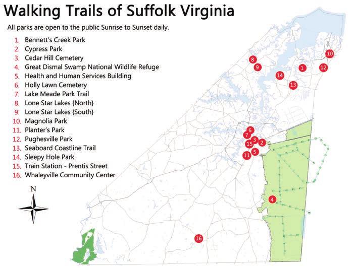
4 Walking Safety Tips Avoid walking alone on trails. Walking with friends is recommended. Tell someone where you re going and when you expect to return. Stay on marked trails. Use sunscreen and insect repellant. Avoid poison ivy. Eating wild berries along the trail is not recommended. Turn back in bad weather. Carry a whistle. It s much more effective than yelling. Attach a whistle to your child s clothing. Carry plenty of drinking water. It isn t safe to drink from streams. Wear appropriate shoes for walking on paths. Check your clothing and body for ticks, at the end of your walk. Talk to children about what to do if they get lost. Bennett s Creek Park 3001 Bennett s Creek Park Road 2 Miles This 57-acre park is located along Bennett s Creek, which enters the Nansemond River. Filled with natural resources such as open space, waterfront and beautiful flora, it features a 1-mile natural surface, easywalking trail that meanders through various sections of this beautiful regional park.


5 Cypress Park 2001 Arizona Avenue.32 Miles A quaint park that s tucked away near downtown and features a.32-mile concrete trail for easy walking, jogging or running, It s surrounded by a multitude of various trees and flora. Cedar Hill Cemetery 524 North Main Street 1 Mile This 37-acre, highly decorated cemetery located in downtown, is on the Historical Landmark list and has many confederate generals buried in it. This 1-mile, asphalt, loop trail makes for easy walking with some very minor inclines. It has beautiful trees and a serene setting.
 The recently constructed LEED Building (Leadership in Energy and Environmental Design) is located in the Fairgrounds section of downtown.")

6 Health and Human Services Building 135 Hall Avenue.2 Miles (building loop) /.33 Miles (lake loop) The recently constructed LEED Building (Leadership in Energy and Environmental Design) is located in the Fairgrounds section of downtown. It features a beautifully paved.2-mile, loop surface for easy walking, and is surrounded by a variety of unique buildings in the surrounding area. Holly Lawn Cemetery 1300 Holly Lawn Parkway 1 Mile A beautiful 35-acre facility located in the business district and surrounded by natural landscapes, Holly Lawn Cemetery is adjacent to one of our premier regional parks, Lake Meade Park. The cemetery features an easy walking, asphalt surface with 6 loops equaling 1 mile.


7 Lake Meade Park Trail 201 Holley Lawn Parkway 2 Miles (red) / 1.2 Miles (yellow) Surrounded by beautiful landscaping, waterfront views set the tone for this easy 2-mile (round trip), stone-dust trail. You can enjoy walking or biking along the trail through beautiful Lake Meade Park. Located in the downtown business district, behind Farm Fresh on Main Street, this regional park offers a secondary 0.6 mile, paved, loop trail around the playground. Lonestar Lakes Regional Park 401 Kings Highway: North Trail 4 Miles Suffolk s best kept secret this beautiful natural resource is 1063 acres with 12 freshwater lakes, one brackish lake, and two brackish creeks. The north trail features a 4- mile (round trip) natural surface for walking, biking and equestrians. It has easy to moderate walking levels.


8 Lonestar Lakes Regional Park 401 Kings Highway: South Trail 1 Mile per loop Tucked away on the scenic south end of the park, is a two-loop, natural-surface trail equaling close to one-mile per loop. It s built for casual and relaxing paces. Magnolia Park 4600 Magnolia Drive.25 Miles Magnolia Park is located on the north end of the city. It s tucked away in the Huntersville Community. This dogleg shaped trail features a.25-paved asphalt path excellent for easy walking.


9 Planters Park 515 York Street.25 Miles Located on Carolina Road, minutes away from downtown, this is a ¼-mile loop trail, fully paved for easy walking, jogging or running. Pughsville Park 5041 Townpoint Road 1 Mile Located in the northern end of the city, this lollipop shaped trail features an asphalt surface for easy walking, jogging or running. Six loops equal one mile or three loops if you include the connector.
, fully paved trail features beautiful views from Historic Driver Village, through Chuckatuck, to the north end at Shoulder s Hill Road.")
 Sleepy Hole Park, located in the Chuckatuck section of the city, is a 74-acre park that sits on the Nansemond River.")
10 Suffolk Seaboard Coastline Trail Driver to Shoulders Hill Road 2.3 Miles one way COMING SOON! Opening in summer/fall, 2015, this 10-foot wide, 2.3 mile (one way), fully paved trail features beautiful views from Historic Driver Village, through Chuckatuck, to the north end at Shoulder s Hill Road. Built specifically for walking and biking, the trail has gradual contours for easy to moderate walking. Sleepy Hole Park 4616 Sleepy Hole Road.5 Miles (upper) /.33 Miles (lower) Sleepy Hole Park, located in the Chuckatuck section of the city, is a 74-acre park that sits on the Nansemond River. There are two asphalt / gravel surface trail loops with some varying contours, creating easy to moderate walking. The upper park loop is.5 miles, and has scenic waterfront views. The lower loop is.33 miles
 Located in the downtown historic section of the city, the east, west and spur trails are fully paved for easy walking, jogging or")

11 Train Station-Prentis Street 326 North Main Street 1.6 Miles (west trail) /.6 Miles (spur trail) Located in the downtown historic section of the city, the east, west and spur trails are fully paved for easy walking, jogging or running. The west trail is.8 miles, the east trail features a quarter mile walk, and the spur trail is.3 miles. Whaleyville Community Center 132 Robertson Street.25 Miles COMING SOON! Opening late fall, 2015, this dogleg-shaped trail, located in the Whaleyville community on the south end of the city, features a 1/4-mile asphalt surface for easy walking, jogging or running.


 986-3705 www.")
12 West Ditch Interior Ditch East Ditch 17-Bus Great Dismal Swamp National Wildlife Refuge 3100 Desert Road 9 Miles 58 Bypass 13 Bypass Bypass Suffolk Virginia North Carolina Sunbury White Marsh Road Desert Daniels Rd. 642 Road 58 Jericho Lane Lynn Ditch Refuge Office 337 Railroad Ditch Jericho Ditch Washington Ditch 58 Williamson Ditch Hudnell Ditch Middle Ditch New Ditch South Ditch Hudnell Ditch Camp Ditch Lake Drummond Chesapeake Big Entry Ditch Portsmouth Ditch Feeder Ditch Dismal Swamp State Park Pasquotank Martin Johnson Road 64 Rosemary Ditch Northeast Ditch River 17 Old Mill Road 17 Dismal Swamp Canal Trail Ballahack Road Dismal Swamp Canal South Mills Williamsburg Wakefield Gloucester Hampton To Norfolk and Virginia Beach 460 Norfolk Virginia Windsor Franklin 64 Beach Suffolk Chesapeake Virginia N. Carolina S. 258 Sunbury Elizabeth City 0 N Legend 13 Miles Kilometers Great Dismal Swamp National Wildlife Refuge Refuge Office Parking Area Boardwalk Trail Auto Tour Route by Permit Trail Entrance Refuge Area Hiking / Biking Trail Boat Access Area Pier To Outer Banks Just 15 minutes from downtown Suffolk and centrally located in the Great Dismal Swamp National Wildlife Refuge, the Washington Ditch entrance is our visitor s favorite walking and biking trail on the refuge. The historic Washington Ditch trail is a scenic 4 1/2 mile natural surface trail ending at the Lake Drummond pier. Also available from the parking area is the 3/4 mile elevated Washington Boardwalk trail. The boardwalk loops deep into the forest habitat giving opportunities for glimpses of local wildlife. (757) www. fws.gov/refuge/great_dismal_swamp (757) (757) (757) (757)
Stephens State Park Trails
 TRAILS OF ALLAMUCHY MOUNTAIN & STEPHENS STATE PARKS Allamuchy Mountain and Stephens State Parks contain 28 marked trails providing access to diverse landscapes for walking, hiking, biking, bird-watching,
proof Northwest District
 1 Northwest District The Northwest Florida Water Management District is the most rural of all five water management districts. From just east of Tallahassee west to the Florida/Alabama line, and from the
Walking Tips. Locations. Good luck on your journey to better health! Earleigh Heights Ranger Station
 Walking Tips Dress in Layers The weather and even your own body temperature can fluctuate as you walk or hike. Layering allows you to comfortably add or remove clothing as needed during your activity.
This Passport: Revised October 20, 2017, EAM # Discovering the Trails of Penfield, NY
 This Passport: Revised October 20, 2017, EAM #161922 Discovering the Trails of Penfield, NY The Town of Penfield is fortunate to have a wide variety of natural resources which make for many unique and
Asheville & WNC Hikes
 Asheville & WNC Hikes Amazingly, we have 3,000+ miles of free public hiking trails near Asheville, including 1,600 miles in the Pisgah and Nantahala National Forests, 850 miles in Great Smokey Mountains
Hiking. Lesson 4.1. Fitness. Hiking
 Lesson 4.1 By Carone Fitness If you enjoy walking, you will probably enjoy hiking. The main difference between hiking and fitness walking is the change in terrain. is typically done in a forest, wilderness,
MARYLAND. Parks, Wildlife Refuges and National Park Service Areas in PATC Area Affected by Proposed Changes to Current Gun Regulations
 Parks, Wildlife Refuges and in PATC Area Affected by Proposed Changes to Current Gun Regulations MARYLAND Antietam National Battlefield -- Sharpsburg Appalachian National Scenic Trail Assateague Island
CELEBRATE WEST GREENWICH GEOCACHING THROUGHOUT WEST GREENWICH
 CELEBRATE WEST GREENWICH GEOCACHING THROUGHOUT WEST GREENWICH The West Greenwich Land Trust (WGLT) is sponsoring Celebrate West Greenwich, an event designed to celebrate the beauty and history of scenic
Best Places to Explore in NC High Country
 Best Places to Explore in NC High Country Caroline McGuire cmcguire@brri.net (828)773-7276 cell (828)263-8711 ext 240 Tweetsie Railroad-a family friendly Wild West theme park located on Highway 321S between
Moving the Economy. To HRTPO Board November 16, 2017 By Robert B. Case, PE, PhD
 Moving the Economy To HRTPO Board November 16, 2017 By Robert B. Case, PE, PhD Moving the Economy How Well the Hampton Roads Transportation System Serves Three Key Economic Sectors: Port Military Hospitality
Discovering the Trails of Prince George s County
 Discovering the Trails of Prince George s County Happy Trails! Since 2005, Wegmans has been partnering with town and city recreation programs and park conservancy groups to encourage folks to get moving
PASSPORT. Discovering the Trails of Webster, NY
 PASSPORT to family wellness Discovering the Trails of Webster, NY Join the Friends of Webster Trails, Webster Health and Education Network, The Town of Webster and Wegmans to get moving more and enjoy
Discover. Ashhurst Domain. Nature s Playground
 Discover Ashhurst Domain Nature s Playground Discover Step back into New Zealand, Aotearoa, of generations long gone. Discover lush natural surrounds echoing with rich birdsong in one of the Manawatu s
Attachment D: PHOTO LOG CITY OF ARCATA RAIL-WITH-TRAIL CONNECTIVITY PROJECT
 01051-09004 Attachment D: PHOTO LOG CITY OF ARCATA RAIL-WITH-TRAIL CONNECTIVITY PROJECT DRAFT: June 30, 2010 Applicant: City of Arcata 736 F Street Arcata, CA 95521 Phone (707) 825-2154 Prepared by: Winzler
Difficult Run Stream Valley Park
 Difficult Run Stream Valley Park The more intense mountain bikers have known about for Difficult Run for some time. Equestrians have known it longer. Eight miles of unpaved trail, the Rails to River Trail
Trail Etiquette. Hours of Operation. Trail Accessibility
 Trail Guide The Elmhurst Park District, with 28 parks and over 460 acres of land, offers nearly six miles of paved or asphalt park trails and maintains an additional 3.6 miles of trails within Elmhurst.
This Passport: Revised October 20, 2017, EAM # Discovering the Trails of Webster, NY
 This Passport: Revised October 20, 2017, EAM #161923 Discovering the Trails of Webster, NY The Town of Webster invites you to explore and experience our diverse outdoor adventures! Here s your opportunity
Hungry 4 History Trivia VA Studies 2010 and beyond
 Hungry 4 History Trivia VA Studies 2010 and beyond Level 1 1 What may be described using terms that show connections between two places such as: next to, near, or bordering? 2 3 What two large bodies of
Blueways: Rivers, lakes, or streams with public access for recreation that includes fishing, nature observation, and opportunities for boating.
 Parks, Open Space and Trails PRINCE WILLIAM COUNTY 2008 COMPREHENSIVE PLAN TRAILS PLAN CONTENTS The components of the trails plan are: Intent Definitions Goals, Policies, and Action Strategies Trails Map
BRYCE CANYON COUNTRY Boulder Mountain Scenic backways itinerary
 BRYCE CANYON COUNTRY Boulder Mountain Scenic backways itinerary Boulder Mountain Area The high plateaus of the Aquarius Plateau (Boulder Mountain), are heavily forested and covered in countless winding
Southern Utah University Hike Brochure
 Southern Utah University Hike Brochure Taylor Creek Trail Twenty minutes from Cedar City Red Hollow An hour and a half from Cedar City Fees: Entrance fee to Kolb Canyon Length: 5 miles round trip Length:
Mazatzal Wilderness Trail Maintenance and Exploration
 Mazatzal Wilderness Trail Maintenance and Exploration March 15-19 (Wednesday - Sunday) Difficulty: Beginner Camping: Car Camping Mileage: Wednesday ~4 miles Thursday ~4-6 miles Friday ~4-6 miles Saturday
Chapter 2: Summary of Existing Open Space System
 Chapter 2: Summary of Existing Open Space System In 1976, the Wake County Board of Commissioners established the Wake County Parks and Recreation Department in order to provide park facilities and programs
APPENDIX G MULTI-USE TRAILS DOWNTOWN LAKELAND
 MULTI-USE TRAILS DOWNTOWN LAKELAND POINCIANA PARKWAY Multi-Use Trails Trail Name From To Status Regional Network Surface Length Present Day Cost Chain-of-Lakes Trail Bridge South of US 17/92 North of US
KETTLE CREEK CONSERVATION AUTHORITY TRAIL GUIDE.
 KETTLE CREEK CONSERVATION AUTHORITY TRAIL GUIDE www.kettlecreekconservation.on.ca EXPLORE OUR TRAILS HIKE OUR TRAILS Kettle Creek Conservation Authority (KCCA) proudly supports and promotes an active lifestyle
NORFOLK INTERNATIONAL AIRPORT TAKEORF.COM NORFOLK INTERNATIONAL AIRPORT 2200 NORVIEW AVENUE NORFOLK, VA
 NORFOLK INTERNATIONAL AIRPORT TAKEORF.COM NORFOLK INTERNATIONAL AIRPORT 2200 NORVIEW AVENUE NORFOLK, VA 23518-5807 WWW.NORFOLKAIRPORT.COM Norfolk International Airport (ORF) is located one mile east of
City of Haslett. City of East Lansing. City of East Lansing
 Central Park North (Nancy L. Moore Park) Lake Park North Expansion White Park Expansion #2 White Park Expansion #1 County East East Haslett East East TF87-212 Acquisition $90,000.00 Park. TF08-138 Acquisition
General Highway System SHEET 1 HILTON HEAD ISLAND URBAN AREA
 5 6 7 8 A A B B General Highway System SHEET 1 HILTON HEAD ISLAND URBAN AREA SECONDARY ROUTE - - - - - 9 WETLAND OR MARSH - - - - - - - - - CHURCH AND CEMETERY - - - - - - - - CEMETERY - - - - - LM 78
What are you getting into?
 Overnight Camping What are you getting into? You will be hiking with your gear to a campground about ½ mile away and spending 1 night camping You will help to prepare a meal over an open flame You will
Montgomery Rural Heritage Byway Tour. Heritage Tourism Alliance of Montgomery County Presents. Shepherd s Hey Barn, Comus
 Shepherd s Hey Barn, Comus Heritage Tourism Alliance of Montgomery County Presents Montgomery Rural Heritage Byway Tour Comus Market, Comus www.heritagemontgomery.org Agricultural Reserve The Agricultural
2019 GROUP EVENTS GUIDE
 2019 GROUP EVENTS GUIDE An Entertainment Cruises Company WELCOME ABOARD For groups of all sizes, cruising delivers a more memorable experience than any venue on land. Come aboard for the most breathtaking
Gardner: overview. Santa Fe, Oregon, and California National Historic Trails UNINCORPORATED JOHNSON COUNTY OLATHE UNINCORPORATED JOHNSON COUNTY
 Santa Fe, Oregon, and California ational Historic Trails : overview 99: p.134 100: p.135 GARDER JUCTIO 102: p.137 56: p.126 EDGERTO Burlington orthern Intermodal and Logistics 98: p.133 101: p.136 S Waverly
SEP MAY 2018 ADVENTURE PASSPORT. FREE Family Outdoor Activity
 FREE Family Outdoor Activity SEP. 2017 MAY 2018 ADVENTURE PASSPORT ADVENTURE CURIOSITY EXPLORATION DISCOVERY SHARING LEARNING Otay Valley Regional Park Multi-Jurisdictional Park County of San Diego City
DELIVERED GREENFIELD PARKWAY Garner, North Carolina 1001 GREENFIELD NORTH CONTACT:
 DELIVERED 1001 GREENFIELD PARKWAY Garner, North Carolina OPTIONAL DOOR PAIR 50'-0" 750-0 200'-0" 50 50 FIRE PUMP ELEC SLOPE DN ROOF ACCESS LADDER SLOPE DN SITE PLAN 151,642 SF OPTIONAL DOOR PAIR 750'-0"
Silver Lake Park An Environmental Jewel for the Citizens of Prince William County
 Silver Lake Park An Environmental Jewel for the Citizens of Prince William County The Prince William Park Authority Mission Statement states: The Prince William County Park Authority will create quality
PRELEASING GREENFIELD PARKWAY Garner, North Carolina 1001 GREENFIELD NORTH PRELEASING 151,642 SF CONTACT:
 PRELEASING 1001 GREENFIELD PARKWAY Garner, North Carolina OPTIONAL DOOR PAIR 200'-0" FIRE PUMP ELEC ROOF ACCESS LADDER SITE PLAN OPTIONAL DOOR PAIR 7 A B 200'-0" C 50' 50' D FIRE PUMP ELEC E ROOF ACCESS
Auburn Trail / Ontario Pathways Trail Connector Feasibility Study Public Information Meeting Wednesday, August 22, 2012
 Auburn Trail / Ontario Pathways Trail Connector Feasibility Study Public Information Meeting Wednesday, August 22, 2012 Purpose of Feasibility Study Purpose Evaluate the feasibility of constructing a multiuse
CHAPTER 4 -- THE LAND USE PLAN: DESCRIPTIONS AND POLICIES FOR THIRTEEN PLANNING AREAS
 CHAPTER 4 -- THE LAND USE PLAN: DESCRIPTIONS AND POLICIES FOR THIRTEEN PLANNING AREAS NORTH CENTRAL CAC AREA LITTLE VALLEY ROAD TO JUG HANDLE CREEK PLANNING AREA This planning area includes Cleone, Noyo,
Swimming Hole Rides (west & North Of Boston) By Rubel Bike Maps READ ONLINE
 By Rubel Bike Maps READ ONLINE") Swimming Hole Rides (west & North Of Boston) By Rubel Bike Maps READ ONLINE If you are searched for the book by Rubel Bike Maps Swimming Hole Rides (west & north of Boston) in pdf format, then you have
Swimming Hole Rides (west & North Of Boston) By Rubel Bike Maps READ ONLINE If you are searched for the book by Rubel Bike Maps Swimming Hole Rides (west & north of Boston) in pdf format, then you have
$866,000. $1,400,000 Health Benefits $13,156,000 TOTAL ANNUAL DIRECT BENEFITS. $10,890,000 Economic Benefits
 SINGING RIVER TRAIL Trails Create Value + Generate Economic Activity Trails generate economic returns through improved health, safety, and environmental conditions, raise property values, and attract visitors.
BEAZLEY FOUNDATION, INC GIFTS AND GRANTS As of December 1, 2004
 BEAZLEY FOUNDATION, INC. 2004 GIFTS AND GRANTS As of December 1, 2004 Academy of Music $ 25,000.00 902 Colonial Avenue PURPOSE: Park View Elementary Strings Program and August 2004 American Red Cross of
Draft 2040 LRTP Candidates
 Ballahack Defense Access s Route 17 Old Battlefield s Centerville Turnpike Mount Pleasant VA Beach City Line Widening and Airport Access West Route 17 alignment Light Rail Existing LRT LRT Extension Survey
April 4, 2014 Chuck McGinness, FDOT TREASURE COAST TRAFFIC REPORT April 4 through April 11, 2014
 April 4, 2014 Chuck McGinness, 954-777-4090 Chuck.McGinness@dot.state.fl.us FDOT TREASURE COAST TRAFFIC REPORT April 4 through April 11, 2014 TREASURE COAST Construction and maintenance-related lane closures
cincinnati including southwest ohio, Southeast Indiana, and Northern Kentucky f i r s t e d i t i o n tamara york
 60 Hikes within 60 MILES cincinnati including southwest ohio, Southeast Indiana, and Northern Kentucky f i r s t e d i t i o n tamara york table of contents Overview Map............................ inside
Sacramento Placerville Transportation Corridor Alternatives Analysis
 Sacramento Placerville Transportation Corridor Alternatives Analysis EL DORADO COUNTY TRANSPORTATION COMMISSION 1 Sacramento Placerville Transportation Corridor 2 Goal of the Project To give public officials
The Transportation Corridor Overlay District
 The Transportation Corridor Overlay District The Transportation Corridor Overlay District is a policy framework under which certain potentially beneficial development proposals may be considered, given
Let our experience be your guide!
 P.O. Box 11043 Norfolk, Virginia 23517 Toll Free: 877.440.0202 Fax: 757.222.0373 www.phillipsdmc.com info@phillipsdmc.com Celebrating 38 years of creating memorable experiences in Coastal Virginia. THE
SOL VS.2a, 2b, 2c, 10b
 What are the characteristics of the Coastal Plain? 1. Also known as Tidewater 2. Located near the Atlantic Ocean and the Chesapeake Bay 3. Includes the Eastern Shore, a peninsula between the Atlantic Ocean
Acquisition in fee simple of approximately one-half acre of property on the shore of Spring Lake to expand the Lakeside Beach Park.
 Lakeside Beach TF00-136 $122,550.00 in fee simple of approximately one-half acre of property on the shore of Spring Lake to exp the Lakeside Beach. 2000 River Ravines TF00-150 $910,000.00 in fee simple
Delaware Wildlife Area
 Delaware Wildlife Area 8 miles away from Delaware 4,670 acre Wildlife Area 1) Take Rt. 36/East Williams Street eastward 2) Take left onto Rt. 42/Lake Street 3) Slight left onto Horseshoe Rd./CR. 220 4)
non-stop flights TAKEORF.COM NORFOLK INTERNATIONAL AIRPORT
 NORFOLK INTERNATIONAL AIRPORT non-stop flights TAKEORF.COM NORFOLK INTERNATIONAL AIRPORT 2200 NORVIEW AVENUE NORFOLK, VA 23518-5807 WWW.NORFOLKAIRPORT.COM Norfolk International Airport (ORF) is located
Port Gamble Shoreline Area Conceptual Trail Proposal
 The North Kitsap Trails Association is pleased to be a partner to the Kitsap Forest and Bay Project and assist Kitsap County, Forterra, Olympic Property Group, Great Peninsula Conservancy and the Port
BRR Leg 1 (3.9 miles, Easy)
") BRR Leg 1 (3.9 miles, Easy) Min 3901 Max 4919 Ascent +21 Descent -1031 0.0 Start (Grayson Highlands State Park Visitor Center) 3.9 Grayson Highlands State Park Office & Gate, on R (EZ 1) Leg Notes: Minimal
BRR Leg 1 (3.9 miles, Easy) Min 3901 Max 4919 Ascent +21 Descent -1031 0.0 Start (Grayson Highlands State Park Visitor Center) 3.9 Grayson Highlands State Park Office & Gate, on R (EZ 1) Leg Notes: Minimal
Frisco Historic Park. Prosit. Sustainability Activity. Insider's Tip. Published on Colorado.com (
 Published on Colorado.com (https://www.colorado.com) Summer in Historic Frisco 3 days More Itineraries Snuggled in the heart of Summit County, Frisco possesses the best of Colorado?s high country. From
Trail Accessibility Guide
 Trail Accessibility Guide Programs and Events The s will make every effort, with two weeks advance notice, to provide reasonable accommodations so that people with disabilities may participate in special
A Day Trip to Silver Falls State Park and Silverton
 A Day Trip to Silver Falls State Park and Silverton One of my favorite Portland day trips is Salem area s Silver Falls State Park. Quite simply, this is a park I make a point to visit at least once a year.
in the St. Croix Valley
 in the Parks Your Guide to in the St. Croix Valley Our parks and trails are fun places to PowerUp! Explore the amazing, family-friendly parks and trails, right here in the St. Croix River Valley. Use this
BOOGIE WOOGIE AUTO TOUR 1
 BOOGIE WOOGIE AUTO TOUR 1 4 6 3 5 7 1 2 10 9 8 Route # 1 Alternate Return Route 1 Historic Harrison County Courthouse & Museum 2 Texas & Pacific Railway Depot & Museum 3 Antebellum Childhood Home Lady
FOR LEASE. 900 NORTH GREENFIELD PARKWAY Garner, North Carolina CONTACT: Jackson Rives
 FOR LEASE Garner, North Carolina 900 GREENFIELD NORTH 29,501 SF AVAILABLE Norfolk Southern Railroad KEY Duke Realty Building Proposed Building Non-Duke Realty Building 45 Trailer Spaces 1300 GREENFIELD
F.O.K.O.S. Friends of Kingston Open Space A GUIDE TO KINGSTON OPEN SPACE
 F.O.K.O.S. Friends of Kingston Open Space A GUIDE TO KINGSTON OPEN SPACE Friends of Kingston Open Space (FOKOS) was formed when a handful of concerned citizens joined together to learn what could be done
P P REMIER LAKE ROPERTIES
 P P REMIER LAKE ROPERTIES SELLER FINANCING AVAILABLE Call for Options Purchase Price: 23 Total Lots - $330,000 Area Details: Whether enjoying an afternoon boat ride with the family, spending the day watching
Crystal Lake Area Trails
 Lake Area Trails Welcome to the Lake area of the Big Snowy Mountains! This island mountain range in central Montana features peaks reaching to 8,600 feet and long, high ridges from which vistas of the
PROPOSED NEW RICHMOND FOLK FESTIVAL MAIN STAGE VENUE AT TREDEGAR GREEN VENTURE RICHMOND JUNE 2013
 PROPOSED NEW RICHMOND FOLK FESTIVAL MAIN STAGE VENUE AT TREDEGAR GREEN VENTURE RICHMOND JUNE 2013 Venture Richmond proposes to develop a new main stage venue for the Richmond Folk Festival on property
ADVENTURE. Activities Offerings ADVENTURE
 Activities Offerings ADVENTURE ADVENTURE Situated on 4,200 acres with 5,000 additional acres of private wilderness, Blackberry Farm is its own unique piece of private wilderness, but surrounding the farm
PLACES TO WALK IN PORT COQUITLAM
 Places to Walk in Port Coquitlam Port Coquitlam is a walker s paradise, whether you re looking for a leisurely stroll or a challenging trek. Lace up your sneakers and try out these 18 walks submitted by
Visitors Guide.
 Visitors Guide www.cummingforsythchamber.org Comein our &Backyard! Play Balloons Over Georgia Adventure at every altitude With convenient access to the North Georgia Mountains, pristine Lake Lanier and
SOUTH WALTON TRAILWAYS
 SOUTH WALTON TRAILWAYS 13 14 15 10 1 2 11 12 3 5 6 4 3 7 9 8 Nestled throughout Walton County are 200 miles of hiking and biking trails winding through state forests, state parks and public-private greenways.
Welcome to the Cross County Trail Public Input Session!
 Welcome to the Cross County Trail Public Input Session! Please sign in on the table below! What are we doing here? Camden County has proposed a bicycle and pedestrian trail spanning across the entire county.
Superstition Wilderness Trails West: Hikes, Horse Rides, And History By Jack Carlson, Elizabeth Stewart
 Superstition Wilderness Trails West: Hikes, Horse Rides, And History By Jack Carlson, Elizabeth Stewart This trail highlights the immense diversity of the desert in a quick 5.5 mile a nice, easy path through
3.0 EXISTING PARK & RECREATION SPACE
 3.0 EXISTING PARK & RECREATION SPACE TOWN PARK & RECREATION SPACE An inventory of current parks and recreation area in the Town of Cedarburg is shown in Table 3. These areas total roughly 381.89 acres.
BOOK 2. Discover Wayne County Trails. Trail Works, Inc. is a volunteer group dedicated to trail development and use.
 Trail Works, Inc. is a volunteer group dedicated to trail development and use. Your membership in Trail Works insures that healthy programs like this continue to thrive. Join today at www.trailworks.org
BULK DISTRIBUTION CENTER
 PRE-LEASING 00 Garner, North Carolina FEATURES & SITE PLAN BUILDING BUILDING SIZE AVAILABLE SF CLEAR HEIGHT 32' COLUMN SPACING Designed to specifications LOADING 55 dock-high doors LIGHTING High bay fluorescent
Priority Trail Projects
 R I V E R P Priority Projects 2018 System Area-wide Projects 3-A: Addressing System for Emergency Responce 3-B: Anacostia Tributary System - Wayfinding Signage 3-D: Develop deploy pilot trail ranger program
Bike Routes of Sault Ste Marie 2017
 Bike Routes of Sault Ste Marie 2017 East Portage - Riverside - Nicolet - Scenic (15-20 miles, mostly flat) Proceed east on Portage Ave. Portage Ave becomes Riverside Drive at Mission Rd. Portage is a wide
ABOUT THE PARKS NANTAHALA NATIONAL FOREST MOUNTAINS NATIONAL PARK CHEROKEE NATIONAL FOREST PISGAH NATIONAL FOREST GREAT SMOKY HIKING TRAILS
 ABOUT THE PARKS GREAT SMOKY MOUNTAINS NATIONAL PARK NANTAHALA NATIONAL FOREST CHEROKEE NATIONAL FOREST PISGAH NATIONAL FOREST GREAT SMOKY MOUNTAINS NATIONAL PARK Straddling the border between North Carolina
CAMP NEW MILFORD. Connecticut Rivers Council Cub Scout Day Camp 2018 PARTICIPANT AND LEADERS GUIDE
 CAMP NEW MILFORD Connecticut Rivers Council Cub Scout Day Camp 2018 PARTICIPANT AND LEADERS GUIDE Harrybrooke Park 100 Still River Dr. New Milford, CT 06776 Monday, July 30 to Friday, August 3, 2018 Jake
Southwest Family Adventure. 7 Days
 Southwest Family Adventure 7 Days Southwest Family Adventure See three amazing National Parks Grand Canyon, Bryce, and Zion on this epic camping trip designed with families in mind. Every day offers magnificent
HISTORIC AMERICAN ENGINEERING RECORD COVE CREEK SPILLWAY BRIDGE. HAER No. AR-83
 HISTORIC AMERICAN ENGINEERING RECORD COVE CREEK SPILLWAY BRIDGE LOCATION: Spanning Cove Creek Spillway at State Highway 309 (formerly Paris-Mt. Magazine Road), Corley vicinity, Logan County, Arkansas UTM:
Section 7: Pick Up Where You Left Off! S-Tree Road over the Todd Road
 2018 TRACE NOTES Helpful information for your adventure on Section 7 of the Hiker Challenge. Start Point S-Tree Rd. End Point Intersection Todd Rd. / Hale Ridge Rd. WEATHER DECISION Weather Alert!!!! Potential
Rafting. Talkeetna, Alaska. Kathy J. Exceptional trips! Go with MT Sobek! Mitch S. Level 3. Activity Level:
 Rafting 6 Days Rafting Spectacular Alaska scenery turns to a steep, fast-water canyon on this adrenalinepacked whitewater adventure on the turquoise Talkeetna River. Part of the appeal is the river's remote
AWARD INTERSTATE. Bid Amount: Less Than 5 Million. Report created on : 4/20/18. Letting Date: 3/28/2018. Estimated Construction Cost.
 : Less Than 5 Million INTERSTATE 202 112417 LOCATION: VARIOUS (NFO)PM2N-060-F18, P401 ADAMS CONSTRUCTION COMPANY 1 $1,418,249.41 $1,440,244.38 ROANOKE PM02458 MONTGOMERY VA SALEM DISTRICT SGR - 2018 PLANT
AUTHORIZATION OF FIELD TRIP: WEEK 1
 AUTHORIZATION OF FIELD TRIP: WEEK 1 trip this Friday, June 22 nd, 2018 at the Norfolk Zoo with Excalibur Gymnastics coaches. The transportation used will be a 15 passenger rental van (depending on the
ANGEL PEAK SCENIC AREA
 Activities: Facilities: ANGEL PEAK SCENIC AREA Hiking, photography, watchable wildlife, camping, picnicking. Note: While formal hiking trails in the area are limited, dispersed hiking opportunities abound
DOWNLOAD OR READ : ROADS OF LAST RESORT PDF EBOOK EPUB MOBI
 DOWNLOAD OR READ : ROADS OF LAST RESORT PDF EBOOK EPUB MOBI Page 1 Page 2 roads of last resort roads of last resort pdf roads of last resort Hampton Roads is the name of both a body of water that serves
Matthew R. "Matt" Hamel. Roland J. Davis, Jr. (I) John M. de Triquet (I)
 John M. de Triquet (I)") OFFICE: Member City Council - CHESAPEAKE CITY Jennifer L. Barnes R. Steve Best Mary Lou Burke Roland J. Davis, Jr. John M. de Triquet Matthew R. "Matt" Hamel Les Smith, Jr. Levin H. Turner Susan R. Vitale
OFFICE: Member City Council - CHESAPEAKE CITY Jennifer L. Barnes R. Steve Best Mary Lou Burke Roland J. Davis, Jr. John M. de Triquet Matthew R. "Matt" Hamel Les Smith, Jr. Levin H. Turner Susan R. Vitale
CAPITAL IMPROVEMENT PLAN FOR THE FIVE YEAR PERIOD ENDING JUNE 30, 2022 ALLOCATION OF RESOURCES
 Cash - GF Transfer Athletic Field Improvements 16-190 - - - - - - 660,000-660,000 Deep Creek AIW Bridge Replacement 08-180 - - - - - - 500,000-500,000 Elizabeth River Park Fishing Pier 19-191 - - - - -
BUILD. Update CONSTRUCTION. In this issue: FEATURED PROJECT: KENT AVENUE ARCH CONSTRUCTION AT THE SJ RIVER VIADUCT FEBRUARY 2019
 BUILD CONSTRUCTION Update FEBRUARY 2019 In this issue: ARCH CONSTRUCTION AT THE SJ RIVER VIADUCT FEATURED PROJECT: KENT AVENUE * Featured Project KENT AVENUE CP 2-3 CONSTRUCTION UPDATE February 2019 At
United States Department of the Interior National Park Service. Boundary Expansion Listed in National Register January 11, 2017
 NPS Form 10900-a (Rev. 8/2002) OMB No. 10240018 United States Department of the Interior National Park Service Boundary Expansion Listed in National Register January 11, 2017 National Register of Historic
PRICE REDUCED. El Encanto FOR SALE - RARE FREESTANDING BUILDING IN TOWN OF CAVE CREEK
 FOR SALE - RARE FREESTANDING BUILDING IN TOWN OF CAVE CREEK SWC CAVE CREEK ROAD & SCHOOL HOUSE ROAD 6331 East Cave Creel Road Cave Creek, Arizona 85331 PRICE REDUCED El Encanto PROPOSED 70 HOMES CAVE CREEK
OBJECTID Description Lat Long Type Jurisdiction Source 1 Greenbrier Large Employment Centers Chesapeake OIPI 2 Gloucester
 OBJECTID Description Lat Long Type Jurisdiction Source 1 Greenbrier 36.781421-76.232292 Large Employment Centers Chesapeake OIPI 2 Gloucester Courthouse 37.408313-76.529152 Large Employment Centers Gloucester
CONTACT: Jackson Rives FOR LEASE OR SALE. BUILD-TO-SUIT NORTH GREENFIELD PARKWAY Garner, North Carolina
 FOR LEASE OR SALE BUILD-TO-SUIT Garner, North Carolina BUILDING 2 49K SF 200' X 745' 00 SPACES (CAR) 8 SPACES (TRAILER) BUILDING 3 49K SF 200' X 745' 00 SPACES (CAR) 8 SPACES (TRAILER) FEATURES & SITE
Non-Motorized Transportation
 Non-Motorized Transportation Non-motorized facilities are important components to the transportation system. They provide an environmentally-friendly, low-cost mode of travel. Some of the facilities can
2. Goals and Policies. The following are the adopted Parks and Trails Goals for Stillwater Township:
 D. PARKS AND TRAILS 1. Introduction Stillwater Township s population is relatively low, with most residents living on rural residences on large lots. The need for active park space has been minimal in
Amtrak service available to Virginia Beach, (800)
") GETTING HERE TIPS FOR Getting Here From the West: I-6, U.S. 60 or U.S. 58; From North & South: I-85, I-95, U.S. 17 or U.S. 1. These intersect with I-6 which connects with I-26 East, leading directly to
GETTING HERE TIPS FOR Getting Here From the West: I-6, U.S. 60 or U.S. 58; From North & South: I-85, I-95, U.S. 17 or U.S. 1. These intersect with I-6 which connects with I-26 East, leading directly to
north GREENFIELD parkway Garner, North Carolina
 BULK build-to-suit north GREENFIELD parkway Garner, North Carolina FEATURES & SITE PLAN 250,000 SF BUILDING BUILDING SIZE 250,000 SF AVAILABLE SF 250,000 SF CLEAR HEIGHT 30' - 32' COLUMN SPACING Designed
Presented By: Deputy Executive Director February 17, 2011
 TRANSPORTATION PROJECT PRIORITIZATION Presented By: Camelia Ravanbakht, Ph.D. Ca e a aaba t,.. Deputy Executive Director February 17, 2011 OVERVIEW 2034 Long-Range g Transportation Plan (LRTP) Process
SCHEDULED GENERAL HIKES As at October 1, 2017
 Please check the Caledon Hills Bruce Trail Club website regularly for additions or changes to the hiking program. Thursday October 12: Dufferin Hi-Land, Mono Cliffs, Map 19, Fall Colours Photography Hike,
TIVERTON, RHODE ISLAND WALK LOOK EXPLORE. 18 miles of Walking Trails through deep woods, pastoral meadows, salt marshes and river vistas
 TIVERTON, RHODE ISLAND WALK LOOK EXLORE 18 miles of Walking Trails through deep woods, pastoral meadows, salt marshes and river vistas WELCOME TO TIVERTON We take great pride in our small town s intimate
Yuba Creek Natural Area Acquisition. Acme Township. Acme Township. TF Acquisition $1,576, Grand Traverse
 Yuba Creek Natural Area TF00-162 $1,576,021.00 in fee simple of 403 acres of critical wetls upl habitat with over 5,000 feet of frontage on Yuba Creek, a tributary to the east arm of Bay. 2000 Petobago
Alpine Trails Mountain Community Development Lands Fernie, British Columbia Winter 2018
 FOR SALE Residential Development Land 228 ± Acres Size: Zoning: Price: 228 +/- Acres R1B and R3 $7,700,000 CAD ($33,772.00 /Acre) $6,055,000 USD ($26,557.00 /Acre) Alpine s Mountain Community Development