Hiking in Connestee Falls
|
|
|
- Esther Spencer
- 6 years ago
- Views:
Transcription


1 Hiking in Connestee Falls Connestee Falls Property Owners Association, Inc. 33 Connestee Trail, Brevard, NC , 1
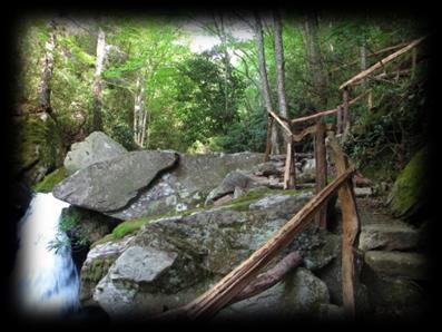
2 Few private communities, or public parks for that matter, can rival the hiking trails at Connestee Falls! The community has over 13 miles of hiking trails maintained by volunteer trail stewards. The trails range from easy to moderate and wind through and around the community s many nature areas offering views of creeks, waterfalls, lakes, mountain vistas and much more. The trail system is extensive and quite elaborately planned and maintained including parking areas at main trailheads. We believe Connestee has one of the best private trail systems in the country! Trailheads are located where a P for parking is shown on the maps. To report a problem on one of our trails or volunteer to help maintain a trail, please contact Tucker Garrison (tgarrison5@comporium.net). Additional information about Connestee Falls hiking is available on the hiker s website at Contents Connestee Hiking Trails Overview... Page 3 Hiking Hints... Page 3 Amakola, Amakola Loop, Carson Creek, Middle Falls and Ogana Trails... Pages 4-5 Ecusta Trail System... Page 6 Equestrian Nature Trail... Page 7 Oakanoah Trail... Page 8 Salola Trail... Page 9 Tall Pines Trace... Pages (Batson Farm Historic Site) 2

3 Hiking Hints When planning a hike, please follow these suggestions: 1. Wear good hiking shoes. 2. Carry plenty of water. 3. Have insect repellent available. 4. Have a copy of the trail map with you. 5. Pack healthy snacks. More hiking hints and scheduled hiking activities are published on the Connestee Falls Hiker s website at: Please note the miles noted on maps are distances for one (1) way. 3

4 Amakola, Amakola Loop, Carson Creek, Middle Falls, and Ogana Trails This complex of five trails and several spur trails offers the possibility of several different loop hikes. A suggested first hike in this area would be to take Amakola, Amakola Loop or Ogana Trail to the Connestee and Batson Creek Falls overlook, then return on Middle Falls Trail. 4


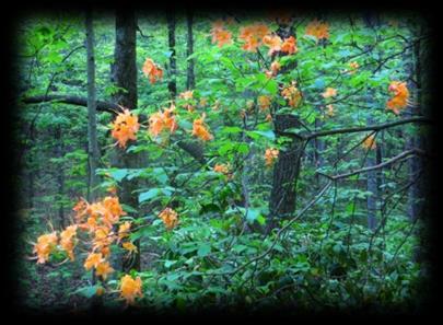
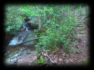
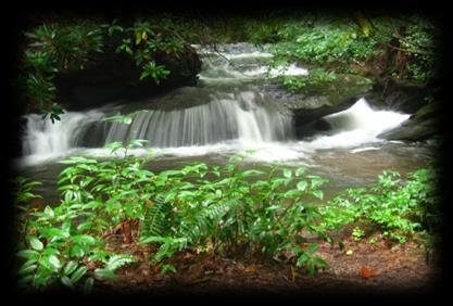
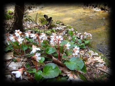
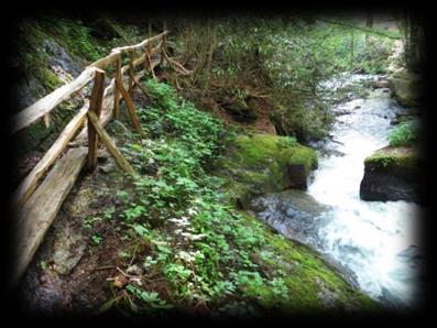
5 Amakola Trail (place where water makes rolling thunder noise) features several spur trails. The first spur after the trail head crosses the creek below Upper Batson Creek Falls and connects to the Ogana Trail. The loop trail to Pisgah View gives a winter view of Mt. Pisgah, and the Cave and new Carson Creek spurs have many interesting rock formations. Amakola Trail ends at an overlook that provides an excellent view of Connestee and Batson Creek Falls. Difficulty level: Easy. Amakola Trail Amakola Loop Trail follows Amakola Brook then crosses Chagee where it becomes an open forest. Views of the French Broad River Valley and Mt Pisgah can be seen from the area above the cave. Rare British Soldiers (Cladonia cristatella) growing on a dead log can also be seen in this area. A new trail extension now connects Amakola Loop directly with the Cave Trail. Difficulty level: Easy. Carson Creek Trail descends 200 feet in elevation from the end of the Cave Trail down 17 switch backs into a boulderfilled gorge to Carson Creek. The creek abounds with cascades and waterfalls before climbing up to intersect Amakola Trail near the top of Connestee Falls. Difficulty Level: Moderately Strenuous. Amakola Loop Trail Middle Falls Trail follows Amakola Brook and Batson Creek. The many cascades and Middle Batson Creek Falls can be best viewed by starting from the Ogana Connector at the north end of the trail so that you are facing the cascades and falls as you come up the trail. Rare Oconee Bells (Shortia galacifolia) and many other native wild flowers grow along the banks of Amakola Brook and Batson Creek. Difficulty level: Easy. Ogana Trail From Ticoa Dam, Ogana Trail provides access to a spur trail with a view of Upper Batson Creek Falls. Short connector trails connect to Middle Falls Trail and Amakola Trail. The Grotto features ferns year round and wildflowers in the spring and early summer, with abundant Jack in the Pulpit and Trillium. Ogana Trail continues past the lay-by for another mile where it passes through open forest and follows a mountain brook before exiting on Dotsi Drive. Difficulty level: Ticoa Dam Trailhead to The Grotto Easy; The Grotto to Dotsi Drive Moderate. Carson Creek Trail Middle Falls Trail 5


6 Ecusta Trail is a loop trail that follows the forested shore of Lake Ticoa, turns up a creek entrance with numerous cascades with heavy rhododendron and hemlock growth, then returns across ferny slopes under a light canopy. Tshakanawi Trail adds some stimulating elevation and open forest areas. Difficulty level: Ecusta Easy, Tshakanawi - moderate. Ecusta and Tshakanawi Trail 6


7 Equestrian Nature Trail The Equestrian Nature Trail entrance is off Ugugu across the street from the former Equestrian Center. The trail begins on a former logging road that follows along Middle Creek. Signs placed along the trail identify various trees and wildflowers. Rare Oconee Bells (Shortia galacifolia) grow prolifically along the banks of Middle Creek. Benches and a picnic table have been placed on the trail to accommodate walkers. Added to the original trail is the Island Trail, which is a favorite spot for seeing Trillium, Jack in the Pulpit, and other wildflowers in the spring. At the water tower, Wanteska View Trail continues to Kelley Mountain through an open hardwood forest that provides winter views of Brevard on one side and Lake Wanteska on the other. Difficulty level: First mile Easy; Mile 1 to Kelley Mountain Moderate. 7


8 Oakanoah Trail Oakanoah Trail begins as a maintenance road that turns off Connestee Trail road near the tennis courts and leads to a large water tank in a few hundred feet. Past the water tank it becomes a foot trail that ascends the crest of the hill, then descends to follow the bank of a beautiful creek through a rhododendron thicket. A proliferation of Flame Azaleas bloom along the trail in summer. The trail intersects Tili Court then continues at the end of Yuda Court. The foot trail continues under an open hardwood forest and ends where the trail becomes private property. Difficulty level: Easy. 8


9 Salola Trails Salola Trail Beginning at the Salola Lane Trailhead the trail meanders through mountain laurel beside a creek. A short detour brings you to the old Beasley Place ruins. Shortly thereafter the trail descends through hemlock and rhododendron alongside numerous cascades. Corral Rock provides views of a beautiful forest cove. The View Point has excellent views of Whiteside and Toxaway Mountains. Lower Salola Trail features many Spring wildflowers and a stream with continuous cascades. Difficulty level: Moderate.. 9
10 Tall Pines Trace Located at the end of Hokassa Court, Tall Pines Trace leads to the ruins of the Frederick V. Batson home. Built around 1910, the stone chimney is all that remains of the house. From the house, the trail continues 0.4 miles through the former Batson farmstead before returning to the trailhead. Difficulty level: Easy. Interpretive Trail Markers 1. In spite of the size of the pines, as of 2007, a professional forester estimated their age at 40-years. This land was cleared in 1910, farmed until 1925 and logged in the 1950s. 2. Fred Batson raised crops here, as evidenced by the discovery of a one-horse "Side Hill" plowshare point that was made in Syracuse, New York before Two of Fred's main known crops were corn and cabbage. 10
11 3. This is believed to have been a form of root cellar known as a "bank house", which is simply a cut into the bank with a wooden enclosure that creates even temperature storage for fruits and vegetables. Fragments of an iron pot and the base of a wood stove were found buried here. 4. This path leads to what is believed to be the Batson's water source. The creek is too shallow to even permit dipping a bucket, but a small earth dam would have pooled sufficient water for easy collection or bathing. 5. Driveway through the "yard", providing access to the road in either direction. 6. Site of Frederick Vernon Batson's 900 square foot two story frame house. Only the stone chimney remains. 7. Stone paved footpath from house to road and lower fields. 8. This area contains several clusters of small locust corner posts arranged in a rectangle. They may be the remains of a small chicken coop. 9. This road connected between Carson Creek Rd to the north (along Setsi Lane near Echota Lane, in Qualla Village), and to East Fork Rd to the south. At that time Carson Creek Rd continued from its current termination all the way to near Connestee's East Fork gate. 10. Headwaters of Laurel Branch creek that passes through Frederick Batson's farm and merges with the East Fork of the French Broad River. 11. Oral history suggests that Fred grew his sorghum cane between the house and the creek, which would include this area. Now club mosses grow here. 12. The Batson's cane mill would have been in this general area (see plaque), on as flat a spot as possible to accommodate the mule that would have walked around the mill that squeezed the juice from the cane. 13. Old farm road with a ford that crosses the creek. 14. Matching pieces of semi-porcelain dishes were found here, in the creek bed. The porcelain's markings identify it as being made in Baltimore in the period 1897-to There was, most likely, a simple log bridge here. This is the continuation of the road that you observed at marker number 9. Traveling south on this road would have taken you to the East Fork Road, near Masters Road. 16. Fred Batson's Barn. Batson Farm Historic Site In 1799, the Joseph Batson family moved from Virginia to Greenville County South Carolina and settled along the Reedy River. They prospered there for many years and many descendants remain in the area. Nonetheless, population growth reduced the availability of affordable land and pressured the more adventuresome members of successive generations to seek their opportunities elsewhere where inexpensive and available land existed. Joseph s son William Asbury was one such person. At the end of the American Civil War, forty-eight year old William Asbury Batson moved from Greenville County South Carolina to the Lake Ticoa area of Connestee Falls, North Carolina with his wife Letty (Lance) and at least 11

12 six of his nine children. One of his sons, Bayles, died in battle as a Confederate soldier near the end of the war. William lived out his life at Connestee as a farmer, Turnpike supervisor and was active in the community, serving quite often as a juror at county court in Brevard. William s second born son, Edward Earle Batson, settled near his father on the western slope of the valley formed by Batson Creek, in the vicinity of Connestee s current Inoli Circle. Edward was active in the East Fork Baptist Church and was an industrious farmer. The bottom of Lake Ticoa was a plateau that contained the Batson family cornfield. Jim Bob Tinsley recounts an interesting tale concerning Edward Earle Batson on page 116 of his book The Land of Waterfalls. Edward s life ended tragically. In 1906, at age 58, a head injury suffered in a farm accident sent him to the State Hospital in Morganton, NC, where he remained until his death in While Edward was a patient at Morganton, Edward s wife Sarah, along with several of her children, joined her oil-prosperous son William Oscar near Los Angeles, California, where she lived until her death in While Edward Earle Batson was at Morganton, his eldest son, Frederick Vernon Batson, purchased a fifty-acre tract of family land from his mother and siblings. This land was the same tract purchased by his father in 1877 and was but a small portion of hundreds of Connestee Falls acres accumulated by the Batson family. Upon what is now Connestee Falls Unit 2, Lot 274, he built a two-story frame house in about 1910 and finally sold it to a land consolidator in It was never occupied again and by the mid-1930s many of its planks had been scavenged by neighbors for firewood. Fred farmed these fifty acres and another 100, growing cabbage, corn and sorghum cane. Despite the steep slopes, Fred was able to grow sufficient surplus crops to sell in Pickens, South Carolina, and on several documented occasions he supplied the County with produce for the chain gang. He was one of the few to own a sorghum cane mill and cooker and his reputation for producing sweet sorghum syrup persisted long after he moved closer to Brevard in This site has been registered with the North Carolina Office of State Archaeology, which designated it as historic site 31TV959** 12
Covenant Health presents
 Covenant Health presents www.covenanthealth.com 1. 2. 3. 4. 5. 6. 7. 8. 9. 10. 11. Trail Guidelines Wear proper hiking shoes. Please be on time. Make sure that you understand & have signed the waiver.
Asheville & WNC Hikes
 Asheville & WNC Hikes Amazingly, we have 3,000+ miles of free public hiking trails near Asheville, including 1,600 miles in the Pisgah and Nantahala National Forests, 850 miles in Great Smokey Mountains
beach. Make the ford and follow the trail out to the junction with Red Creek Tr in an open grassy area.
 Description: This is a moderate to slightly strenuous 22.8 mile backpack (add 2.6 miles if you do the packless out and back to the Lion s Head) that will have you exploring nearly every thing that is The
ABOUT THE PARKS NANTAHALA NATIONAL FOREST MOUNTAINS NATIONAL PARK CHEROKEE NATIONAL FOREST PISGAH NATIONAL FOREST GREAT SMOKY HIKING TRAILS
 ABOUT THE PARKS GREAT SMOKY MOUNTAINS NATIONAL PARK NANTAHALA NATIONAL FOREST CHEROKEE NATIONAL FOREST PISGAH NATIONAL FOREST GREAT SMOKY MOUNTAINS NATIONAL PARK Straddling the border between North Carolina
Black Hill Regional Park, Little Seneca Lake
 Black Hill Regional Park, ittle Seneca ake ittle Seneca ake, in Black Hill Regional Park, is a reservoir created after a previous drought struck the Washington area. The park is under Maryland-National
This Passport: Revised October 20, 2017, EAM # Discovering the Trails of Penfield, NY
 This Passport: Revised October 20, 2017, EAM #161922 Discovering the Trails of Penfield, NY The Town of Penfield is fortunate to have a wide variety of natural resources which make for many unique and
Blue Ridge Hiking Club - First Quarter 2018 Hikes
 Blue Ridge Hiking Club - First Quarter 2018 Hikes Monday, Jan 1: Trout Lake to Manor House & Figure 8 Trail: Meet at Trout Lake parking lot, at 9:30. (1st exit left off Parkway just south of Cone Manor
Tiger Mountain State Forest:
 98 60 hikes within 60 miles: SEATTLE 20 Tiger Mountain State Forest: West Tiger Mountain Three Loop i KEY AT-A-GLANCE INFORMATION Length: 5.1 miles round-trip Configuration: Loop Difficulty: Moderate difficult
ROAD SCHOLAR SPRING HIKING ADVENTURE Tentative Schedule April 8-13, 2018
 Sunday, April 8 ROAD SCHOLAR SPRING HIKING ADVENTURE Tentative Schedule April 8-13, 2018 PM 3:00-5:00 Arrival, registration and move in to the dorm. 6:00 Supper EVE 7:00 Welcome & Orientation, Sign Ups
Southern Utah University Hike Brochure
 Southern Utah University Hike Brochure Taylor Creek Trail Twenty minutes from Cedar City Red Hollow An hour and a half from Cedar City Fees: Entrance fee to Kolb Canyon Length: 5 miles round trip Length:
Hiking Las Vegas.com
 Hike: Mt. Wilson via First Creek Canyon route Trailhead: First Creek marked Distance: 10 miles up and back Elevation gain: 3,400 feet Elevation of Peak: 7,070 feet Time: 7 to 9 hours (up and back) Difficulty:
Matthiessen State Park Dells Area Hike
 90 Easy Hikes Close to Home At the south end of the hike, you ll climb on top of a mound left over from a former coal-mining operation in the park. Not far from Goose Lake Prairie, the town of Morris hosts
Blue Ridge Hiking Club Hike List July- September 2016
 Blue Ridge Hiking Club Hike List July- September 2016 Saturday, July 2, Elk Knob: 3.8 mile round trip with 900 ft. gain in elevation. Spectacular views at the summit. The trails are mostly moderate, but
Best Hikes on Orcas Island
 Published on San Juan Islands Washington Visitors Bureau Orcas Island Lopez Island Friday Harbor San Juan Island (https://www.visitsanjuans.com) Best Hikes on Orcas Island The Emerald Isle offers big trees,
The gorges of Mohican Park in Ohio create a hiker's paradise Sunday, May 22, 2011 By Bob Downing, Akron Beacon Journal
 Pittsburgh Post-Gazette The gorges of Mohican Park in Ohio create a hiker's paradise Sunday, May 22, 2011 By Bob Downing, Akron Beacon Journal Bob Downing Big Lyons Falls drops 80 feet into a shady U-shaped
Hatchet and Weogufka Creeks Treasures of Coosa County. Roger Vines County Extension Coordinator
 Hatchet and Weogufka Creeks Treasures of Coosa County Roger Vines County Extension Coordinator Overview Coosa County The Heart of Alabama Very rural county with an abundance of natural resources forestland,
On The Trail. Twelve Mile Run and Kunes Camp Trail ---splendid solitude! By Gary Thornbloom
 On The Trail Twelve Mile Run and Kunes Camp Trail ---splendid solitude! By Gary Thornbloom Twelve Mile Run is about as isolated as you can get in the Quehanna Wild Area. You will find solitude and silence
Little Grand Canyon near Pomona, Illinois
 Little Grand Canyon near Pomona, Illinois Below: View of the trail and the terrain created using the Map My Hike app Below: Summary of the hike created using the Map My Hike app Presented by: Jennifer
Staunton River Trail to Hoover Camp and Fork Mtn. Relay Tower (Based on September 18, 2013 hike by Ron Singleton, Fredericksburg, Va.
 Staunton River Trail to Hoover Camp and Fork Mtn. Relay Tower (Based on September 18, 2013 hike by Ron Singleton, Fredericksburg, Va.) The President's Cabin (The "Brown" House) at Camp Hoover. Sign on
Griffith Park Trail Run Trail Guide Click for
 The Griffith Park Trail Run by Hike- LosAngeles.com Griffith Park Trail Run Trail Guide Click for downloadable cell phone guide and map from EveryTrail. DISTANCE: 4.55 Miles ELEVATION: 1280' ELEVATION
TENNESSEE MOUNTAIN LIVING
 NOVEMBER 2016 Featuring Jasper Highlands TNLand.com END of the YEAR December 26th to Land Sale December 31st See back cover for more info... TENNESSEE MOUNTAIN LIVING JASPER HIGHLANDS - TENNESSEE'S MOST
Trail Beginning Elevation: 7553 ft The Poison Creek Trailhead is located at the end of National Forest Road 646E (NF-646E).
.") West Mountain Trails Poison Creek Trail #134 Length: 2.9 miles (4.7 km) Difficulty Horseback: A good trail for the first time west mountain rider, some steep sections Hiking: Most Difficult USGS Maps:
West Mountain Trails Poison Creek Trail #134 Length: 2.9 miles (4.7 km) Difficulty Horseback: A good trail for the first time west mountain rider, some steep sections Hiking: Most Difficult USGS Maps:
GIFFORD PINCHOT NATIONAL FOREST
 GIFFORD PINCHOT NATIONAL FOREST 9341 Wright Meadow 93 Spencer Meadow Spencer Butte 4247' 30 30A 19 24 80 31C Lewis River Lower Falls 5 Quartz Creek 90 Taidnapam Falls Upper Falls 31 Spencer Peak 3861'
Piestewa Peak/Dreamy Draw Trail Guide
 Piestewa Peak/Dreamy Draw Trail Guide Trail #1A - Perl Charles Memorial Trail Length: 4.8 miles Elevation: 2,200 ft. - 1,340 ft. Difficulty: Moderate to difficult The Perl Charles trailhead is located
43 STONE MOUNTAIN LOOP
 204 60 hikes within 60 miles: atlanta 43 STONE MOUNTAIN LOO i KEY AT-A-GLANCE INFORMATION LENGTH: 5.5 miles CONFIGURATION: Loop DIFFICULTY: Easy SCENERY: Views of Stone Mountain and Confederate Memorial;
Hiking Las Vegas.com
 Hike: Juniper Peak up and back Trailhead: Oak Creek Canyon marked Distance: 5.5 miles round trip Elevation gain: 2,200 feet Elevation peak: 6,109 feet Time: 4 to 5 hours - Up and back Difficulty: 3 Danger
F.O.K.O.S. Friends of Kingston Open Space A GUIDE TO KINGSTON OPEN SPACE
 F.O.K.O.S. Friends of Kingston Open Space A GUIDE TO KINGSTON OPEN SPACE Friends of Kingston Open Space (FOKOS) was formed when a handful of concerned citizens joined together to learn what could be done
Crystal Lake Area Trails
 Lake Area Trails Welcome to the Lake area of the Big Snowy Mountains! This island mountain range in central Montana features peaks reaching to 8,600 feet and long, high ridges from which vistas of the
Visitor s Center 110 E. Meeting Street Morganton, NC
 5 unique trails worth checking out! Cross-Country skiing! No snakes! Don t sweat it! www.discoverburkecounty.com Visitor s Center 110 E. Meeting Street Morganton, NC Photo of Table Rock by Justin Costner
Location: Height: Access: Distance: Elevation: Season: Difficulty: Lat/Long: Directions:
 Upper Eagle Falls Upper Eagle Falls (~20 ft.) is a short hike up from the roadside at the Eagle Falls picnic area. It is very difficult to get a parking spot here during the day, so it is recommended to
To Wellness. To Wellness PASSPORT PASSPORT. Partners. Partners. Ashland County Health & Human Services 630 Sanborn Avenue, Ashland, WI
 Partners Ashland County Health & Human Services 630 Sanborn Avenue, Ashland, WI Ashland Bretting Center 320 4th Avenue W., Ashland, WI PASSPORT Bayfield County Health Department 117 E. 6th Street, Washburn,
Hiking Trail Descriptions
 Hiking Trail Descriptions For ye shall go out with joy. And be led forth with peace. The mountains and the hills shall break forth before you in singing. And all the trees of the fields shall clap their
A Publication of Friends of Sleeping Bear Dunes
 A Publication of Friends of Sleeping Bear Dunes 2014, Friends of Sleeping Bear Dunes, P.O. Box 545, Empire, MI 49630 www.friendsofsleepingbear.org info@friendsofsleepingbear.org Learn more about the Friends
Family Hiking Day on the Appalachian Trail
 Family Hiking Day on the Appalachian Trail September 30, 2017 Guided Hikes and Trail Celebrations In celebration of National Public Lands Day, September 30th is Family Hiking Day on the Appalachian Trail!
C E N T R A L C A T S K I L L S
 120 C E N T R A L C A T S K I L L S Central Catskills Once out of the southern parts of the Catskills, the Long Path enters the more well traveled and civilized regions. The trail joins the Devil s Path,
Walking Tips. Locations. Good luck on your journey to better health! Earleigh Heights Ranger Station
 Walking Tips Dress in Layers The weather and even your own body temperature can fluctuate as you walk or hike. Layering allows you to comfortably add or remove clothing as needed during your activity.
LAS VARAS RANCH CA COASTAL TRAIL PROPOSED ALIGNMENT
 LAS VARAS RANCH CA COASTAL TRAIL PROPOSED ALIGNMENT Santa Barbara Trails Council * Prepared by Ray Ford February 1,2012 The following notes accompany the Santa Barbara Trails Council map for the Las Varas
ROAD SCHOLAR SPRING HIKING ADVENTURE Tentative Schedule April 9-14, 2017
 ROAD SCHOLAR SPRING HIKING ADVENTURE Tentative Schedule April 9-14, 2017 Sunday, April 9 PM 3:00-5:00 Arrival, registration and move in to the dorm. 6:00 Supper EVE 7:15 Welcome & Orientation, Sign Ups
Non-motorized Trail Plan & Proposal. August 8, 2014
 Town of Star Valley Ranch, Wyoming and the Star Valley Ranch Association in partnership with the USDA Forest Service, Bridger-Teton National Forest, Greys River Ranger District Non-motorized Trail Plan
Explore your Town With The Kingston Area Trail Passport
 Explore your Town With The Kingston Area Trail Passport Don t forget to stop at the children's room in the library for your prize when you collect 5 Passport Stamps! For more natural resource related information,
The Croatan MST Segment 16B
 1 Mountains-to-Sea Trail Last Updated 1/1/2017 A sandy road through longleaf pine savanna in the Croatan National Forest Photo by PJ Wetzel, www.pjwetzel.com The Croatan MST Segment 16B STELLA TO THE NEUSIOK
Other Agencies and Organizations
 Daniel Boone National Forest 1700 Bypass Road WInchester, KY 40391 859-745-3100 Location Northern terminus is near Morehead, Kentucky. Southern terminus is located in the Big South Fork NRRA in Tennessee.
Friday October 3. Lower Javelina Trail - Level D. about 3 miles, less than 500. Hike Contact: Joel Tormoen
 Friday October 3 Lower Javelina Trail - Level D. about 3 miles, less than 500 Hike Contact: Joel Tormoen joeltormoen@gmail.com Depart WB trailhead 8:00 am - return before 11:00 am This quite easy hike
Suggested Day Hikes. Mount Greylock State Reservation 3, 4 1, 2. Take a Hike! Things to remember:
 Suggested Day Hikes Mount Greylock State Reservation Take a Hike! This guide offers suggested day hike routes in two parts: 1) Year-round Hikes and 2) Seasonal Hikes (late-may to Nov.1). Use this guide
UMASS CROSS-COUNTRY Trails
 UMASS CROSS-COUNTRY Trails 1) EGG (43 min) (A) From Cage proceed to North Pleasant street (by campus pond). Make left and head toward LGRT and pass School of Education. Pass Puffton Apt complex (on left)
Baltimore County Nature Quest NEW TRAILS 2014
 Baltimore County Nature Quest NEW TRAILS 2014 Nature Quest Park Locations Robert E. Lee Park Cromwell Valley Park Agricultural Ctr. & Farm Park Honeygo Regional Park Marshy Point Park and Nature Center
Rogue Gorge (Mt. Stella) Roadless Area-- T30S R3E (primarily in portions of Sections 23, 26, 33, 34 & 35)
 Roadless Area-- T30S R3E (primarily in portions of Sections 23, 26, 33, 34 & 35)") Rogue Gorge (Mt. Stella) Roadless Area-- T30S R3E (primarily in portions of Sections 23, 26, 33, 34 & 35) Rogue River-Siskiyou National Forest--High Cascades Ranger District Upper, higher elevation trail
Rogue Gorge (Mt. Stella) Roadless Area-- T30S R3E (primarily in portions of Sections 23, 26, 33, 34 & 35) Rogue River-Siskiyou National Forest--High Cascades Ranger District Upper, higher elevation trail
Section 7: Pick Up Where You Left Off! S-Tree Road over the Todd Road
 2018 TRACE NOTES Helpful information for your adventure on Section 7 of the Hiker Challenge. Start Point S-Tree Rd. End Point Intersection Todd Rd. / Hale Ridge Rd. WEATHER DECISION Weather Alert!!!! Potential
Stephens State Park Trails
 TRAILS OF ALLAMUCHY MOUNTAIN & STEPHENS STATE PARKS Allamuchy Mountain and Stephens State Parks contain 28 marked trails providing access to diverse landscapes for walking, hiking, biking, bird-watching,
GOLDEN EARS PROVINCIAL PARK
 GOLDEN EARS PROVINCIAL PARK Trail Information as of October 10 th 2015 Do not underestimate the mountainous wilderness of Golden Ears Provincial Park. The combination of rugged terrain and rapidly changing
Beaver Creek State Park
 GENERAL INFORMATION Name of Park/Forest/Facility: Beaver Creek State Park County: Columbiana (St. Clair Township) Address: 12816 Sprucevale Road (ie County Rd 428) (street #, city) East Liverpool, Ohio
The High Peaks and Asheville MST Segment 3. PISGAH INN TO BLACK MOUNTAIN CAMPGROUND By Jim Grode
 1 Mountains-to-Sea Trail Last Updated 1/1/2017 Approaching Blackstock Knob Photo by Jeff Clark www.internetbrothers.org The High Peaks and Asheville MST Segment 3 PISGAH INN TO BLACK MOUNTAIN CAMPGROUND
H U D S O N P A L I S A D E S
 14 H U D S O N P A L I S A D E S Hudson Palisades The southernmost sections of the Long Path follow the Hudson River and the Hudson Palisades north, staying close to the river and to civilization. Although
A Day Trip to Silver Falls State Park and Silverton
 A Day Trip to Silver Falls State Park and Silverton One of my favorite Portland day trips is Salem area s Silver Falls State Park. Quite simply, this is a park I make a point to visit at least once a year.
Marilla Reservoir to Chestnut Ridge via Marilla Trails and Bullis Hollow Trail east to west
 USGS topographic maps useful to this hike are the Bradford and Stickney 7.5 minute sectionals. These notes are designed to assist in identifying distance and location using geophysical and man-made characteristics
State of New Jersey, Department of Environmental Protection Division of Parks and Forestry State Park Service njparksandforests.
 State of New Jersey, Department of Environmental Protection Division of Parks and Forestry State Park Service njparksandforests.org STOKES STATE FOREST STOKES STATE FOREST, located in Sussex County, New
t 18.8(17.7) Arrive at Warwoman Road where there is metal historical sign honoring William Bartram. Continue directly across
 Arrive at Warwoman Road where there is metal historical sign honoring William Bartram. Continue directly across") Rd 0.9 mi. is Bob Gap. Pool Creek Rd is often in poor shape aft(lr Bob Gap but it can be taken an additional -1.3 mi. to Hwy. 76,6 mi. east ojclayton, GA.) l3.3 (23.2) After climb through laurel tum right
Rd 0.9 mi. is Bob Gap. Pool Creek Rd is often in poor shape aft(lr Bob Gap but it can be taken an additional -1.3 mi. to Hwy. 76,6 mi. east ojclayton, GA.) l3.3 (23.2) After climb through laurel tum right
Cumberland County Hiking Marathon Trail Descriptions
 Cumberland County Hiking Marathon Trail Descriptions 8/28/2017 Welcome to the 2017 Cumberland County Hiking Marathon. As you hike these trails you will enjoy a wide variety of terrain and geographical
CRAZY HORSE TRAIL GUIDE
 CRAZY HORSE TRAIL GUIDE Abridged Version: July 2016 This is a short form of our interpretive trail guide for the Crazy Horse Trail. The full version of the guide has a more detailed description of the
(west) onto Charleston Boulevard. Drive 16 miles on Charleston and turn right into Red Rock
 onto Charleston Boulevard. Drive 16 miles on Charleston and turn right into Red Rock") Hike: North Peak and Ice Box Overlook up and back Trailhead: 2.5 miles up the Rocky Gap Road not mark Distance: 5 miles round trip Elevation gain: 2,694 feet Elevation Peak: 7,094 feet Time: 3 to 5 hours
Hike: North Peak and Ice Box Overlook up and back Trailhead: 2.5 miles up the Rocky Gap Road not mark Distance: 5 miles round trip Elevation gain: 2,694 feet Elevation Peak: 7,094 feet Time: 3 to 5 hours
Cataloochee. Fishing Species Rainbow Trout and Brook Trout. Recreation
 Cataloochee River Information The Cataloochee River is located in the historic Cataloochee Valley--a relatively remote part of Smoky Mountain National Park. The campground is a secluded setting and offers
Seven Ponds Nature Center's Great Wildflowers of the Great Smoky Mountains April 15-20, 2018
 Seven Ponds Nature Center's Great Wildflowers of the Great Smoky Mountains April 15-20, 2018 Introduction The Southern Appalachians contain some of our country's most impressive natural features. The area
Trail Phasing Plan. Note: Trails in the Clear Creek Canyon area (Segments will be finalized in the future to minimize wildlife impacts
 Note: Trails in the Clear Creek Canyon area (Segments 2 5 and a future JCOS connection) will be finalized in the future to minimize wildlife impacts Trail Phasing Plan P Parking 3 Easy Trail Intermediate
2019 Work Week Crew. Schedule and Descriptions
 2019 Work Week Crew WAWONA WW1 Mariposa Grove Restoration and Invasive Plant Removal June 2 June 8 YOSEMITE VALLEY YV1 Washington Column Climber s Trail Rehabilitation June 9 June 15 YV2 Weed Warriors/
Driving Time: 3 hours (allow extra time for stops)
") Scenic Byways loop This journey takes visitors through the eastern edge of Mt. Rainier National Park and along two of Washington s most beloved scenic byways, the Chinook Byway and the White Pass Scenic
Scenic Byways loop This journey takes visitors through the eastern edge of Mt. Rainier National Park and along two of Washington s most beloved scenic byways, the Chinook Byway and the White Pass Scenic
Guide to. Suffolk. Walking. Trails. Lake Meade Park
 Walking Lake Meade Park Guide to Suffolk Trails Lake Meade Park Lonestar Lake Regional Park Walking Safety Tips Avoid walking alone on trails. Walking with friends is recommended. Tell someone where you
West Trails Trek Guide. Chief Pontiac Trail Credential Hikes
 West Trails Trek Guide Kensington Start Edition Chief Pontiac Trail Credential Hikes RDS.WTW.110609 WP# Dist. Accum. Dist. Accum. Feet Miles Meters Meters 1 0 0.0 0 0 2 410 0.1 125 125 3 164 0.1 150 275
March Hello everyone,
 Hello everyone, March 2015 Our first trip of 2015 found us at the Santee National Wildlife Refuge. It was sunny most of the day with highs in the low 50s and a steady breeze that made it feel much cooler.
Logan Canyon Hiking Trail Guide
 C a c h e V a l l e y V i s i t o r s B u r e a u Logan Canyon Hiking Trail Guide Monique Beeley Legend Trail Location Guide WASATCH CACHE NATIONAL FOREST WILDERNESS PAVED WATER TRAILHEAD 9 Logan River
Fall 2017 Hiking Schedule All Hikes Depart From Pavilion Across From White Pine and Hemlock Lodges
 Pace Codes: Fall 2017 Hiking Schedule All Hikes Depart From Pavilion Across From White Pine and Hemlock Lodges Leisurely: Nature or historical walk; frequent stops for observation Moderate: Steady, 1 to
Peak to Peak MST Segment 1A
 1 Mountains-to-Sea Trail Last Updated 1/1/2017 Peak to Peak MST Segment 1A View from the Mountains-to-Sea Trail at Clingmans Dome Photo by Danny Bernstein CLINGMANS DOME TO WATERROCK KNOB ALTERNATE ROUTE
Route #1) Mt. of the Holy Cross - North Ridge
 Mt. of the Holy Cross - North Ridge") Climbing 14ers can be very dangerous, please read the Mountaineering Safety Page and make sure you have a map+compass and can use them effectively, without the help of electronic devices. Route #1) Mt.
Climbing 14ers can be very dangerous, please read the Mountaineering Safety Page and make sure you have a map+compass and can use them effectively, without the help of electronic devices. Route #1) Mt.
Waterfall Hikes Of North Georgia By Jim Parham READ ONLINE
 Waterfall Hikes Of North Georgia By Jim Parham READ ONLINE Waterfall Hikes of North Georgia includes 60 hikes to more than 200 waterfalls, all on public land in the mountains of north Georgia. Each hike
CARVER S FALLS. Cumberland County s Natural Beauty. What s Included In This Information Packette
 Cumberland County s Natural Beauty What s Included In This Information Packette History of the Falls Boy Scouts have acquired Right of Use Guidelines for Usage Application Check-out Report HISTORY AND
Sunrise Ranch 6890 acres, Jeff Davis County, Texas On the Fort Davis Scenic Loop
 Sunrise Ranch 6890 acres, Jeff Davis County, Texas On the Fort Davis Scenic Loop 432-386-2821 Cell 432-426-2024 Office james@kinglandwater.com King Land & Water LLC P.O. Box 109, 600 State Street, Fort
HIGH POINT STATE PARK
 State of New Jersey, Department of Environmental Protection Division of Parks and Forestry State Park Service njparksandforests.org HIGH POINT STATE PARK TRAILS OF HIGH POINT STATE PARK There are thirteen
APPENDIX 19-II. Ontario Trail Network Trailheads EAST-WEST TIE TRANSMISSION PROJECT AMENDED ENVIRONMENTAL ASSESSMENT REPORT
 EAST-WEST TIE TRANSMISSION PROJECT AMENDED ENVIRONMENTAL ASSESSMENT REPORT APPENDIX 19-II Ontario Network heads Report. 1536607/2000/2219 Ontario Network heads in the n-commercial Land and Resource Use
This Passport: Revised October 20, 2017, EAM # Discovering the Trails of Webster, NY
 This Passport: Revised October 20, 2017, EAM #161923 Discovering the Trails of Webster, NY The Town of Webster invites you to explore and experience our diverse outdoor adventures! Here s your opportunity
Hiking in São Miguel, Pico & Faial 9 nights
 Explore the ancient world of volcanoes on foot. Track the origins of São Miguel, Pico and Faial Islands and experience some of the thermal springs and nature at its finest. This is a package that lets
BRR Leg 1 (4.0 miles, Easy)
") BRR Leg 1 (4.0 miles, Easy) Min 3881 Max 4948 Ascent +36 Descent -1027 0.0 Start (Grayson Highlands State Park Visitor Center) 4.0 Grayson Highlands State Park Office & Gate, on L (EZ 1) Leg Notes: Minimal
BRR Leg 1 (4.0 miles, Easy) Min 3881 Max 4948 Ascent +36 Descent -1027 0.0 Start (Grayson Highlands State Park Visitor Center) 4.0 Grayson Highlands State Park Office & Gate, on L (EZ 1) Leg Notes: Minimal
County Line trail - Miller Peak to Little Navaho
 County Line trail - Miller Peak to Little Navaho 7-17-2008 This hike features a portion of the County Line trail in the Teanaway that receives extremely little use despite offering a spectacular ridge-run
Skyline Drive Hogback Canon City
 Skyline Drive Hogback Canon City Direction to trailhead: From US 50, turn north onto 15th Street. At the traffic circle, continue north on 15th Street until it dead ends at Washington Street (about 1.5
The President James K. Polk State Historic Site Teacher s Packet
 The President James K. Polk State Historic Site Teacher s Packet 2008-2009 Mailing Address: PO Box 475 Pineville, NC 28134 Street Address: 12031 Lancaster Highway Pineville, NC 28134 (704) 889-7145 phone
Telluride-to-Moab Alternative Singletrack Options
 Telluride-to-Moab Alternative Singletrack Options Day 1 Day 1 Alternate 1: Galloping Goose to Deep Creek. 18.4 miles, ascent 3,530ft, descent 1,388ft. This is fun, flowey, moderate to intermediate singletrack
CIEC 9 PEAKS AWARD SUPPLEMENT POSSIBLE ROUTES FOR THE 9 PEAKS AWARD TRIP
 CIEC 9 PEAKS AWARD SUPPLEMENT POSSIBLE ROUTES FOR THE 9 PEAKS AWARD TRIP As you plan your trip, be aware of 3 regulations in this wilderness: 1. Camp only in designated campsites. 2. No campfires allowed.
Hole in the Rock Scenic Backway
 Hole in the Rock Scenic Backway The Hole in the Rock Scenic Backway leads one along the pioneer path created by a Mormon Expedition. Approximately 55 miles one-way from Highway 12 to the Hole-inthe-Rock,
Note: Coordinates are provided as Universal Transverse Mercator UTM Zone U21, North American Datum 1983 (NAD 83).
.") Northern Traverse Route Description The Northern Traverse (formerly the North Rim Traverse) is an unmarked and rugged backcountry hiking route. It is known be a demanding hike, because of its terrain and
Northern Traverse Route Description The Northern Traverse (formerly the North Rim Traverse) is an unmarked and rugged backcountry hiking route. It is known be a demanding hike, because of its terrain and
KSNH SPRING CONFERENCE GREAT SMOKY MOUNTAINS April 10-13, 2014
 KSNH SPRING CONFERENCE GREAT SMOKY MOUNTAINS April 10-13, 2014 ALL TRIPS LEAVE FROM THE QUALITY INN UNLESS OTHERWISE STATED All meals are on your own. Quality Inn full breakfast opens at 6 am daily. PLEASE
SECTION 1: MARYLAND TO PA nd CROSSING MASON DIXON LINE TO RAINSBURG GAP BUCHANAN STATE FOREST, PRIVATE LAND, SGL 97
 SECTION 1: MARYLAND TO PA 326 2 nd CROSSING MASON DIXON LINE TO RAINSBURG GAP BUCHANAN STATE FOREST, PRIVATE LAND, SGL 97 Web Update, August 2010 http://www.hike mst.org Section 1 follows Tussey Mountain
A DESERT CAMPING GUIDE FOR ANZA BORREGO DESERT STATE PARK
 A DESERT CAMPING GUIDE FOR ANZA BORREGO DESERT STATE PARK With over 500,000 acres of beautiful terrain, Anza Borrego Desert State Park offers endless opportunities for Boy Scout Troops, Venture Crews and
Trekking at Peuma Hue
 Trekking at Peuma Hue Peuma Hue is a paradise for those who love hiking and trekking. A large variety of trails cross pristine forest, ancient rocks and stunning waterfalls with beautiful views over the
Top Trails: Great Smoky Mountains National Park: 50 Must-Do Hikes For Everyone By Johnny Molloy
 Top Trails: Great Smoky Mountains National Park: 50 Must-Do Hikes For Everyone By Johnny Molloy Slide 43 of 51: Located in the Great Smoky Mountains, the Located in the heart of Rocky Mountain National
Lava Mountain Trail Distance: Elevation Range: Trail Type: Difficulty: Season: Driving Distance: Driving Time: USGS Maps: Pros Cons
 Lava Mountain Trail Distance: 13.4 miles (including the side trip to North Star Lake) Elevation Range: 5900'-8330' Trail Type: singletrack Difficulty: moderate Season: late June-October Driving Distance:
Watch Outs! Will Your Home Survive? The Homeowner s Watch Outs! will allow you to evaluate your situation and set a plan to correct any concerns.
 Homeowner s Watch Outs! Will Your Home Survive? The Homeowner s Watch Outs! will allow you to evaluate your situation and set a plan to correct any concerns. Each year, hundreds of homes are destroyed
Eagle Rock Loop Ouachita National Forest Page 1 of 8
 EAGLE ROCK LOOP Eagle Rock Loop Ouachita National Forest Page 1 of 8 Hiking: Biking: Equestrian: Trail Highlights: This trail offers the longest loop trail in Arkansas. A combination of the Little Missouri,
Hiking in São Miguel, Pico & Faial 7 nights
 Explore the ancient world of volcanoes on foot. Track the origins of São Miguel, Pico and Faial Islands and experience some of the thermal springs and nature at its finest. This is a package that lets
APPENDIX D: SUSTAINABLE TRAIL DESIGN. APPENDICES Town of Chili Parks and Recreation Master Plan Update
 APPENDIX D: SUSTAINABLE TRAIL DESIGN APPENDICES Town of Chili Parks and Recreation Master Plan Update Sustainable Trail Construction Sustainable trails are defined by the US Forest Service as trails having
Royal Gorge Far Out Trail to Le Point
 Royal Gorge Far Out Trail to Le Point Direction to trailhead: From East Ridge Campground: Drive west from Canon City on US 50 to County Road 3A, the entrance road to the Royal Gorge Park. Turn left onto
Skiing and Snowshoes on Un-groomed Fernan Saddle Terrain
 Skiing and Snowshoes on Un-groomed Fernan Saddle Terrain Three ski or snowshoe routes are available from the Fernan Saddle Parking Lot which either do not cover routes ordinarily groomed for snow machine
Evaluation of Outstanding Remarkable Values for Collawash River March 2011
 Evaluation of Outstanding Remarkable Values for Collawash River March 0 Segment From headwaters of East Fork Collawash River to Buckeye Creek Mileage: miles Free flowing: Yes Scenic:, Substantial River