PASSPORT. Discovering the Trails of Webster, NY
|
|
|
- Gyles Carpenter
- 6 years ago
- Views:
Transcription

1 PASSPORT to family wellness Discovering the Trails of Webster, NY

2 Join the Friends of Webster Trails, Webster Health and Education Network, The Town of Webster and Wegmans to get moving more and enjoy area trails. Visit: Thank you, Marcie Bartolotta, M.S. Manager eat well live well Community Initiatives Wegmans Food Markets Ron Nesbitt Webster Town Supervisor The Wegmans Passport to Family Wellness is an on-going program sponsored by Wegmans. For more information on trail maps, contact Friends of Webster Trails at 1

3 Playground Parking Kodak Run 2
4 Webster Arboretum Location: on Schlegel Road, between Salt & Basket Difficulty: Very Easy Length: 1.3 miles Features: The Webster Arboretum is a place to see a unique garden of natural beauty. The site is multi-use to include leisure, educational and cultural activities in a natural setting. It also enhances awareness of the value, beauty and need for protection of our botanical resources. It offers quiet reflection, beauty, sight, smell and sounds of nature. *Walking, Hiking, Jogging, Snowshoe, Cross Country Ski MAKE TRAIL MARKER RUBBING HERE indicates TRAIL MARKER. 3

5 4
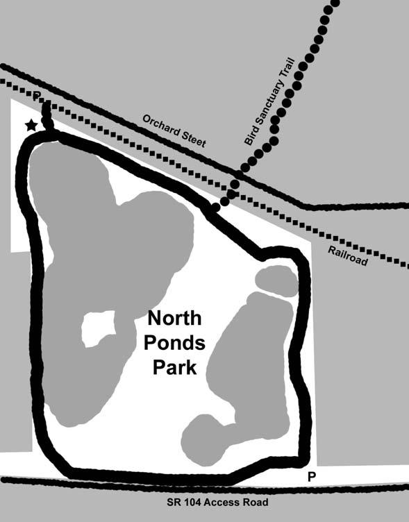
6 Bird Sanctuary Trail Location: off Orchard Street, north of North Ponds Difficulty: Very Easy Length: approximately 0.9 miles Features: The Bird Sanctuary Trail is a linear trail between North Ponds Park walking path and State Route 250. Currently, a bird sanctuary is being constructed. *Walking, Jogging, Hiking, Snowshoe, Cross Country Ski MAKE TRAIL MARKER RUBBING HERE indicates TRAIL MARKER. 5
7 Phillips Road Chiyoda Drive Chiyoda Trail Parking Webster Parks & Recreation Office To Bird Sanctuary Trail 6 Webster Road Rt. 250
8 Chiyoda Trail Location: 1350 Chiyoda Drive (Webster Recreation Center) off Phillips Road, across from Xerox Difficulty: Easy Length: 1 mile Features: This is a paved loop trail located on the Webster Recreation Property. The trail winds through trees and loops back to the fitness facility. The trail connects to the Bird Sanctuary Trail. *Walking, Hiking, Jogging, Biking MAKE TRAIL MARKER RUBBING HERE indicates TRAIL MARKER. 7

9 8
10 Finn Park Nature Trail Location: off Maple Drive, north of Route 104 Difficulty: Easy Length: 1.25 miles Features: Finn Park consists of 50 acres of land located just north of Route 104 between Maple Road and Gravel Road. Parking can be found at Liberty Lodge, off of Maple Drive. The trail begins in the woodlot behind Liberty Lodge. Start at the South East corner of the Liberty Lodge lawn. The trail travels 0.25 mile, over a small stream, through a mature beech forest, to a perimeter trail around a meadow. This meadow trail circles 0.75 mile around ideal monarch butterfly habitat. The footpath parallels Shipbuilder s Creek before finally looping back. Follow the wooded trail back to Liberty Lodge. *Walking, Hiking, Jogging, Snowshoe, Cross Country Ski MAKE TRAIL MARKER RUBBING HERE indicates TRAIL MARKER. 9

11 10 RIDGE TRAIL
12 Gosnell Big Woods Preserve GO TO BACK PAGE OF BOOK TO MAKE TRAIL MARKER RUBBING Big Field Trail Location: parking lot is at the corner of Vosburg and Drumm Roads. Difficulty: Easy Length: 1.2 miles Features: Big Field Trail follows the perimeter of the field. This trail is great for Cross Country Skiing. It provides beautiful views of the grassland field and wildflowers. Walks on this trail may include seeing turkeys, deer and a variety of birds. Big Woods Trail Location: starts 0.2 miles north of Big Field Trail parking lot Difficulty: Moderate Length: approx. 1.2 miles parking lot to Lake Road Features: In an effort to not disturb the natural character of the woods, there are no blazes to mark the trail and minimal trail clearing. The trail is easy to follow and the reward is the spectacular beauty of the Big Woods. The trail provides access to one of the few remaining old-growth forests in the area. *Walking, Hiking, Jogging, Snowshoe, Cross Country Ski NO BIKES ALLOWED. indicates TRAIL MARKER.

13 Van Alstyne Herman 12
14 Hojak Trail Location: follows rail bed from Lake Road to North Ponds Park Difficulty: Very Easy Length: 3.5 miles Features: The Hojack Trail is a walking and biking trail from Lake Road to North Ponds Park on the rail bed of the abandoned Hojack Line. Parking is available at Vosburg Hollow Nature Preserve, North Ponds and the cross roads. *Walking, Hiking, Jogging, Snowshoe, Cross Country Ski, Biking MAKE TRAIL MARKER RUBBING HERE indicates TRAIL MARKER. 13
15 14
16 North Ponds Park Location: off Rt. 104, between Holt Road & Rt. 250 Difficulty: Very Easy Length: 1 mile Features: The park offers 8 handicapped fitness stations and a sledding hill at the north end of the park. Parking is available just off Route 104 and to the north in lot off Orchard Street. The ponds are also open for fishing. *Walking, Hiking, Jogging, Biking, Snowshoe, Cross Country Ski MAKE TRAIL MARKER RUBBING HERE * Don t forget the Rt. 104 Bike Path Location: Runs between Bay and Philips Roads. Start at Bay Rd. to marker at Hard Rd. (2.75 miles) or start at Salt Rd. to marker (3.75 miles). Length: 6.5 miles total indicates TRAIL MARKER. 15

17 16 Parking
18 Vosburg Hollow Nature Trail Location: Park in the area behind the pumping station and take the Hojack Trail 1/8 mile to the trail on the left. Difficulty: Easy Length:.25 miles Southwest of Vosburg Road Features: It leads north along a stand of red pines and descends to a boardwalk across a marshy area. It ends in a glade of flowers and ground cover next to Shipbuilders Creek. Take the bridge over Shipbuilders Creek and climb the stairs up to the parking area. *Walking, Hiking, Jogging, Snowshoe MAKE TRAIL MARKER RUBBING HERE indicates TRAIL MARKER. 17
19 18
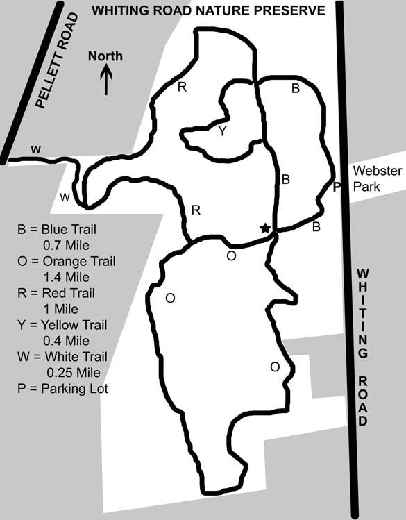
20 Whiting Road Nature Preserve Location: between Pellett and Whiting Roads, south of Lake Rd. Park at the parking area on Whiting Rd. Trail/Difficulty/Length/Features: Blue Loop Trail, Easy, level walk,.75 mile provides access through the shrub-seedling and sapling-pole forest adjacent to Whiting road. Yellow Trail, Moderate walk: a rolling terrain with a couple of short, steep slopes,.4 mile provides access through the young to mature growth forest west of the blue trail. Orange Loop Trail, Easy level walk with a couple of moderate slopes, 1.4 mile provides access to the primarily grass-forb and shrub-seedling areas and some mature woods. Red Trail, Moderate with long slopes, 1 mile provides access to the mature to climax beech forest on the western part of the preserve. *Walking, Hiking, Jogging, Snowshoe, Cross Country Ski MAKE TRAIL MARKER RUBBING HERE indicates TRAIL MARKER. 19
21 20
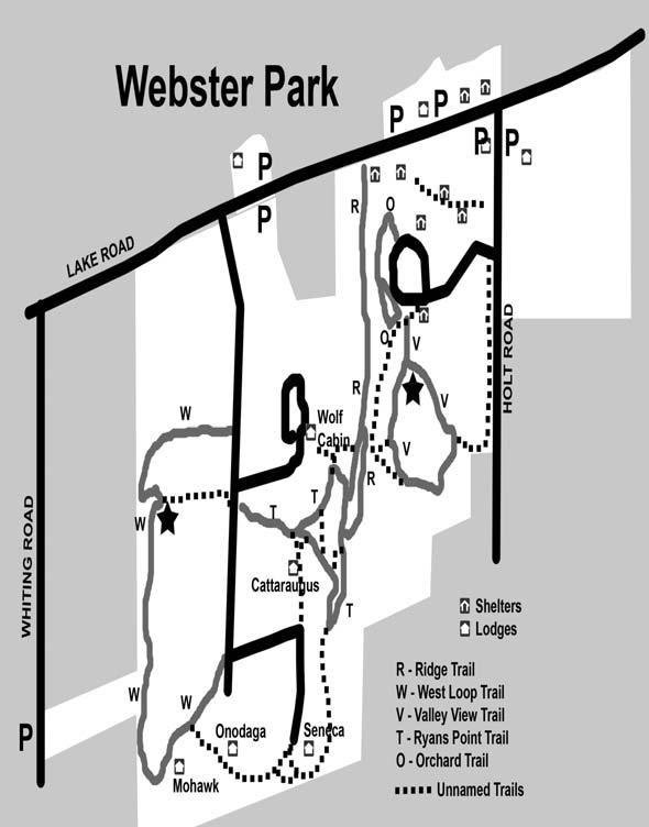
22 Webster Park Location: off Holt and Lake Roads Difficulty: Easy Length: Valley View Trail is.6 miles Length: West Trail is 1.6 miles Features: Discover 550 acres of beautiful, evergreen planted slopes, rolling lakeshore breakers and cool green valleys. The East Trail passes through a former orchard that is filled with seckle pear, apple, crabapple, and cherry trees. This trail is full of birds in the spring and summer months. The West Trail features wooded areas which are a great habitat for wild turkey. Additional information on Trails at Webster Park: *Walking, Hiking, Jogging, Snowshoe, Cross Country Ski MAKE TRAIL MARKER RUBBING HERE indicates TRAIL MARKERS. (Room for 2nd rubbing next page.) 21
23 MAKE TRAIL MARKER RUBBING HERE This Passport Belongs to: Name Age Address Phone Field Notes: 22
24 TRAIL RECORD Date Trail Page 23


25 The Town of Webster is fortunate to have a wide variety of natural resources which make for many unique and picturesque trails. We hope you will enjoy and protect our environment. Always be safe and please leave the trails the same way you found them. The Friends of Webster Trails is a volunteer group and functions as part of the Town of Webster. Their trail stewardship is widely recognized and greatly appreciated. Please see our website ( if you are interested in volunteering or would like more information about this dedicated group.
This Passport: Revised October 20, 2017, EAM # Discovering the Trails of Webster, NY
 This Passport: Revised October 20, 2017, EAM #161923 Discovering the Trails of Webster, NY The Town of Webster invites you to explore and experience our diverse outdoor adventures! Here s your opportunity
This Passport: Revised October 20, 2017, EAM # Discovering the Trails of Penfield, NY
 This Passport: Revised October 20, 2017, EAM #161922 Discovering the Trails of Penfield, NY The Town of Penfield is fortunate to have a wide variety of natural resources which make for many unique and
This Passport: Revised March 20, 2017, EAM # Discover the Trails of Perinton, NY
 This Passport: Revised March 20, 2017, EAM #161921 Discover the Trails of Perinton, NY The Town of Perinton invites you to explore and experience our diverse outdoor adventures! Here s your opportunity
A Publication of Friends of Sleeping Bear Dunes
 A Publication of Friends of Sleeping Bear Dunes 2014, Friends of Sleeping Bear Dunes, P.O. Box 545, Empire, MI 49630 www.friendsofsleepingbear.org info@friendsofsleepingbear.org Learn more about the Friends
CRAZY HORSE TRAIL GUIDE
 CRAZY HORSE TRAIL GUIDE Abridged Version: July 2016 This is a short form of our interpretive trail guide for the Crazy Horse Trail. The full version of the guide has a more detailed description of the
Friends of Webster Trails
 Friends of Webster Trails advocates for the preservation of the natural character of Webster s open space lands. We promote this through sensible management, education and lowimpact access. We advise the
To Wellness. To Wellness PASSPORT PASSPORT. Partners. Partners. Ashland County Health & Human Services 630 Sanborn Avenue, Ashland, WI
 Partners Ashland County Health & Human Services 630 Sanborn Avenue, Ashland, WI Ashland Bretting Center 320 4th Avenue W., Ashland, WI PASSPORT Bayfield County Health Department 117 E. 6th Street, Washburn,
proof Northwest District
 1 Northwest District The Northwest Florida Water Management District is the most rural of all five water management districts. From just east of Tallahassee west to the Florida/Alabama line, and from the
Baltimore County Nature Quest NEW TRAILS 2014
 Baltimore County Nature Quest NEW TRAILS 2014 Nature Quest Park Locations Robert E. Lee Park Cromwell Valley Park Agricultural Ctr. & Farm Park Honeygo Regional Park Marshy Point Park and Nature Center
BOOK 2. Discover Wayne County Trails. Trail Works, Inc. is a volunteer group dedicated to trail development and use.
 Trail Works, Inc. is a volunteer group dedicated to trail development and use. Your membership in Trail Works insures that healthy programs like this continue to thrive. Join today at www.trailworks.org
Calvert Regional Park - Tari Moore Recreational Trail. Calvert Regional Park - Woodland Trail. miles from Rising Sun
 Calvert Regional Park - Tari Moore Recreational Trail 304 Brick Meeting House Road, North East, MD 21901 5.2 about 1.1 mile Paved parking lot, plentiful Easy, paved path with slight incline. Easy, paved
Asheville & WNC Hikes
 Asheville & WNC Hikes Amazingly, we have 3,000+ miles of free public hiking trails near Asheville, including 1,600 miles in the Pisgah and Nantahala National Forests, 850 miles in Great Smokey Mountains
Discovering the Trails of Prince George s County
 Discovering the Trails of Prince George s County Happy Trails! Since 2005, Wegmans has been partnering with town and city recreation programs and park conservancy groups to encourage folks to get moving
Trail Etiquette. Hours of Operation. Trail Accessibility
 Trail Guide The Elmhurst Park District, with 28 parks and over 460 acres of land, offers nearly six miles of paved or asphalt park trails and maintains an additional 3.6 miles of trails within Elmhurst.
Walking Tips. Locations. Good luck on your journey to better health! Earleigh Heights Ranger Station
 Walking Tips Dress in Layers The weather and even your own body temperature can fluctuate as you walk or hike. Layering allows you to comfortably add or remove clothing as needed during your activity.
F.O.K.O.S. Friends of Kingston Open Space A GUIDE TO KINGSTON OPEN SPACE
 F.O.K.O.S. Friends of Kingston Open Space A GUIDE TO KINGSTON OPEN SPACE Friends of Kingston Open Space (FOKOS) was formed when a handful of concerned citizens joined together to learn what could be done
MONTGOMERY TOWNSHIP OPEN SPACE & PATHWAYS COMMITTEE
 MONTGOMERY TOWNSHIP OPEN SPACE & PATHWAYS COMMITTEE Meetings: 2 nd Wednesday of each month @ 6:30 PM in the Municipal Building Questions? Call the Open Space Coordinator, Lauren Wasilauski, at (908) 359-8211
IOWA ORNITHOLOGISTS' UNION - Birding Sites in Dallas County
 IOWA ORNITHOLOGISTS' UNION - Birding Sites in Dallas County Printed on 7/19/2018 Beaver Bottoms Wetland (restricted) (Important Bird Area) GPS Coordinates:, Ownership: Private (see directions for access)
Stephens State Park Trails
 TRAILS OF ALLAMUCHY MOUNTAIN & STEPHENS STATE PARKS Allamuchy Mountain and Stephens State Parks contain 28 marked trails providing access to diverse landscapes for walking, hiking, biking, bird-watching,
Mountain Biking and Off Road Trails in Warren County, New York
 Mountain Biking and Off Road Trails in Warren County, New York Warren County Safe and Quality Bicycling Organization 96 Country Club Road Queensbury, NY 12804 www.bikewarrenco.org Warren County Safe and
Trail Phasing Plan. Note: Trails in the Clear Creek Canyon area (Segments will be finalized in the future to minimize wildlife impacts
 Note: Trails in the Clear Creek Canyon area (Segments 2 5 and a future JCOS connection) will be finalized in the future to minimize wildlife impacts Trail Phasing Plan P Parking 3 Easy Trail Intermediate
Cuyahoga Valley National Park Ohio
 Cuyahoga Valley National Park Ohio Brandywine Falls The Ledges The Beaver Marsh Temperate Deciduous Forest How To Get There... Located between Cleveland & Akron, Ohio Cuyahoga Valley National Park can
Hiking Trail Descriptions
 Hiking Trail Descriptions For ye shall go out with joy. And be led forth with peace. The mountains and the hills shall break forth before you in singing. And all the trees of the fields shall clap their
Trail Accessibility Guide
 Trail Accessibility Guide Programs and Events The s will make every effort, with two weeks advance notice, to provide reasonable accommodations so that people with disabilities may participate in special
Rail Trail Walking Challenge!
 Included with these routes is the Municipality of the District of Lunenburg s trail brochure. This map gives a rough estimate of the locations of our 6 rail trails, all managed by volunteer associations!
NORTH GEORGIA MOUNTAINS, USA. Knights Mill Farm
 NORTH GEORGIA MOUNTAINS, USA Knights Mill Farm Knights Mill Farm NORTH GEORGIA MOUNTAINS, USA Introduction: This historically significant property is perfect for development into a family compound with
CAMP ROCK RANCH JACK KAVANAUGH RMABROKERS.COM
 CAMP ROCK RANCH JACK KAVANAUGH 303.909.1706 JACK@RMABROKERS.COM RMABROKERS.COM CAMP ROCK RANCH COLORADO - CLEAR CREEK COUNTY - UPPER BEAR CREEK ROAD, EVERGREEN The 162±-acre Camp Rock Ranch is surprisingly
Friends of Webster Trails
 Friends of Webster Trails FWT Newsletter Fall 2016 Yellow Trail at Four Mile Creek Preserve is Open Bridge Project Leader and Eagle Scout Taran Bauer Cutting the Yellow Trail Ribbon (H. Von Gehlen photo)
The striking colours of the setting sun reflecting on the waters is how Crimson Lake received its name. Crimson Lake Provincial Park is a meeting
 The striking colours of the setting sun reflecting on the waters is how Crimson Lake received its name. Crimson Lake Provincial Park is a meeting place of foothills forests in the west, bog and muskeg
UMASS CROSS-COUNTRY Trails
 UMASS CROSS-COUNTRY Trails 1) EGG (43 min) (A) From Cage proceed to North Pleasant street (by campus pond). Make left and head toward LGRT and pass School of Education. Pass Puffton Apt complex (on left)
Southern Utah University Hike Brochure
 Southern Utah University Hike Brochure Taylor Creek Trail Twenty minutes from Cedar City Red Hollow An hour and a half from Cedar City Fees: Entrance fee to Kolb Canyon Length: 5 miles round trip Length:
Friends of Webster Trails
 Friends of Webster Trails FWT Newsletter Spring 2018 New Bridge from Big Field to Big Woods at GBWNP Upcoming Events April 9 th @ 7pm (Monday) Next monthly FWT Board Meeting. Members invited to attend
Bangor Land Trust & Girl Scouts
 Bangor Land Trust & Girl Scouts This collection of fact sheets will walk you through many activities for Brownie, Junior, Cadette and Senior Girl Scouts and how Bangor Land Trust can help you do them!
beach. Make the ford and follow the trail out to the junction with Red Creek Tr in an open grassy area.
 Description: This is a moderate to slightly strenuous 22.8 mile backpack (add 2.6 miles if you do the packless out and back to the Lion s Head) that will have you exploring nearly every thing that is The
ASRA 2018 Hike Schedule
 ASRA 2018 Hike Schedule Date/Day Destination Hike Info Meeting Info Leader Feb 10, Saturday Stagecoach and 9:00 at the Confluence kiosk. Manzanita trails Parking fee required. We ll hike along the trail
Mazatzal Wilderness Trail Maintenance and Exploration
 Mazatzal Wilderness Trail Maintenance and Exploration March 15-19 (Wednesday - Sunday) Difficulty: Beginner Camping: Car Camping Mileage: Wednesday ~4 miles Thursday ~4-6 miles Friday ~4-6 miles Saturday
Maya s Creek Crossing Hwy 17 N acres $185,000 Fort Davis, Texas
 Maya s Creek Crossing Hwy 17 N 14.98 acres $185,000 Fort Davis, Texas James King, Agent Office 432-426-2024 Cell 432-386-2821 James@KingLandWater.com King Land & Water LLC P.O. Box 109, 600 State Street,
Sunrise Ranch 6890 acres, Jeff Davis County, Texas On the Fort Davis Scenic Loop
 Sunrise Ranch 6890 acres, Jeff Davis County, Texas On the Fort Davis Scenic Loop 432-386-2821 Cell 432-426-2024 Office james@kinglandwater.com King Land & Water LLC P.O. Box 109, 600 State Street, Fort
155 acres on Tyaughton Lake 900 feet of Pristine Waterfront Private & Secluded Property
 155 acres on Tyaughton Lake 900 feet of Pristine Waterfront Private & Secluded Property 946 Tyaughton Lake Road Gold Bridge BC V0K1P0 900 ft of waterfront with 155 acres of south facing easy access. This
Film Location Prospectus
 Film Location Prospectus NYS Park s Taconic Region in New York s Hudson Westchester, Putnam, Dutchess & Columbia Counties www.parks.ny.gov Janeen M. Martin Marketing/PR Coordinator, Taconic Region 9 Old
Hit the Trails. First Day Hikes. Membership. trailworks.org
 Hit the Trails First Day Hikes Membership trailworks.org Over 30 people took part in our Wayne County First Day Hikes, ringing in the New Year at one of three locations: Casey Park, Black Brook Park, and
SEP MAY 2018 ADVENTURE PASSPORT. FREE Family Outdoor Activity
 FREE Family Outdoor Activity SEP. 2017 MAY 2018 ADVENTURE PASSPORT ADVENTURE CURIOSITY EXPLORATION DISCOVERY SHARING LEARNING Otay Valley Regional Park Multi-Jurisdictional Park County of San Diego City
Acquisition in fee simple of approximately one-half acre of property on the shore of Spring Lake to expand the Lakeside Beach Park.
 Lakeside Beach TF00-136 $122,550.00 in fee simple of approximately one-half acre of property on the shore of Spring Lake to exp the Lakeside Beach. 2000 River Ravines TF00-150 $910,000.00 in fee simple
Ortiz River Ranch Pagosa Springs, Colorado
 Ortiz River Ranch Pagosa Springs, Colorado This ranch provides an exceptional opportunity to own a property with frontage on the San Juan and Navajo Rivers, lush irrigated pastures, and beautiful rolling
OTZINACHSON REGIONAL GROUP OF THE SIERRA CLUB Edward Abbey Hiking Society Spring- Summer 2013 Outings Schedule
 For more information contact: Paul Shaw, Outings Chair 155 Mowery Lane Sunbury PA 17801 717-215- 8339 pshaw@ptd.net Saturday, March 23: Switchback Railroad, Carbon County 11 miles, moderate to strenuous.
C E N T R A L C A T S K I L L S
 120 C E N T R A L C A T S K I L L S Central Catskills Once out of the southern parts of the Catskills, the Long Path enters the more well traveled and civilized regions. The trail joins the Devil s Path,
Friends of Webster Trails
 Friends of Webster Trails FWT Newsletter Fall 2018 Hidden Gems Hike Vosburg Hollow June 2nd (see article) Upcoming Events November 10th Hot Cocoa Hike 7:00pm Four Mile Creek Preserve November 12th FWT
Beaver Creek State Park
 GENERAL INFORMATION Name of Park/Forest/Facility: Beaver Creek State Park County: Columbiana (St. Clair Township) Address: 12816 Sprucevale Road (ie County Rd 428) (street #, city) East Liverpool, Ohio
Delaware Wildlife Area
 Delaware Wildlife Area 8 miles away from Delaware 4,670 acre Wildlife Area 1) Take Rt. 36/East Williams Street eastward 2) Take left onto Rt. 42/Lake Street 3) Slight left onto Horseshoe Rd./CR. 220 4)
PIONEER PARK. City of Des Peres Parks Master Plan. SWT Design 46 INTRODUCTION
 PIONEER PARK INTRODUCTION Pioneer Park is a 7 acre neighborhood park located east of Interstate 270 and south of Manchester Road along Tallie Road. The park is situated in a residential neighborhood with
PROPOSED PARK ALTERNATIVES
 8 Chimne y Rock State Park M a ster Pl an 2011 PROPOSED PARK ALTERNATIVES Introduction Three different park development concepts were prepared and presented to the citizens of North Carolina through a
Trail Beginning Elevation: 7553 ft The Poison Creek Trailhead is located at the end of National Forest Road 646E (NF-646E).
.") West Mountain Trails Poison Creek Trail #134 Length: 2.9 miles (4.7 km) Difficulty Horseback: A good trail for the first time west mountain rider, some steep sections Hiking: Most Difficult USGS Maps:
West Mountain Trails Poison Creek Trail #134 Length: 2.9 miles (4.7 km) Difficulty Horseback: A good trail for the first time west mountain rider, some steep sections Hiking: Most Difficult USGS Maps:
The following criteria were used to identify Benchmark Areas:
 7.0 BENCHMARK AREAS The Churn Creek Protected Area offers a significant opportunity to learn more about how grassland ecosystems function. One of the key tools that will be used to monitor larger grassland
City of Keller Parks and Facilities Inventory
 City of Keller Parks and Facilities Inventory April 2013 1. BEAR CREEK PARK 44 ACRES 1 Basketball Court with 2 goals 4 Drinking Fountains 1 Large Pavilion with 4 picnic tables, electricity and fireplace
Vermont Cows by Peter Salmon
 Vermont Cows by Peter Salmon SUSTAINABLE FOREST & PROPERTY MANAGEMENT: At current the Dorset Town Forest includes the 30 acre parcel that sits atop Owl s Head peak in Dorset. By acquiring this property
Best Hikes on Orcas Island
 Published on San Juan Islands Washington Visitors Bureau Orcas Island Lopez Island Friday Harbor San Juan Island (https://www.visitsanjuans.com) Best Hikes on Orcas Island The Emerald Isle offers big trees,
Cincinnati Nature Center s
 120 60 hikes within 60 miles: cincinnati 24 Cincinnati Nature Center s Rowe Woods i KEY AT-A-GLANCE INFORMATION Length: 8.9 miles Configuration: Loop Difficulty: Difficult Scenery: Forest, ponds, prairie,
S H A W A N G U N K R I D G E T R A I L
 214 Shawangunk Ridge Trail The Shawangunk Ridge Trail was originally conceived as a relocation of the Long Path from Harriman State Park to Minnewaska State Park. Now part of the Long Path system, the
HIGH POINT STATE PARK
 State of New Jersey, Department of Environmental Protection Division of Parks and Forestry State Park Service njparksandforests.org HIGH POINT STATE PARK TRAILS OF HIGH POINT STATE PARK There are thirteen
playwinterpark.com Off The Beaten Path Hikes Hiking Recommendations for the Adventurous Hiker
 playwinterpark.com Off The Beaten Path Hikes Hiking Recommendations for the Adventurous Hiker Hike: Devil s Thumb (difficult) Length: 3.93 miles one-way Elevation: Trailhead 9609 Destination 12,236 Trailhead
Welcome to North Harpersfield NY Pg 1. General Information Directions Map of Property.Lodging.Area Attractions. General Information
 Welcome to North Harpersfield NY Pg 1 General Information Directions Map of Property.Lodging.Area Attractions General Information Welcome to North Harpersfield. George Rand and Pamela Ryder invite Fyke
BRYCE CANYON COUNTRY Boulder Mountain Scenic backways itinerary
 BRYCE CANYON COUNTRY Boulder Mountain Scenic backways itinerary Boulder Mountain Area The high plateaus of the Aquarius Plateau (Boulder Mountain), are heavily forested and covered in countless winding
BASSETTS CREEK SECTION CONTENTS: BASSETTS CREEK BRYN MAWR LUCE LINE
 BASSETTS CREEK SECTION CONTENTS: BASSETTS CREEK BRYN MAWR LUCE LINE GLENWOOD AVE MULTI-USE DIAMONDS VINCENT AVE N MORGAN AVE N PENN AVE N DOG PARK MULTI-USE FIELDS PLAYGROUND AK E RD S CHESTNUT AVE DA
throu Booth Hill Green Belt
 s k r a p s l l u b m u r T Explore gh Geocaching throu Booth Hill Green Belt This was originally a concept to try and preserve some of the land in our town, without hurting the developers that are creating
Pinellas County Environmental Lands
 Pinellas County Environmental Lands In addition to traditional parks and recreation facilities, Pinellas County owns and manages a system of environmental lands that provides specialized resource-based
Dogwood Lane Trail Guide
 Dogwood Lane Trail Guide Activity Book & www.arkansasstateparks.com Lake Frierson State Park Trail Station Answers 1. urushiol oil 2. gray and fox squirrels 3. black dye 4. chewing gum, tobacco, root bear,
Black Hill Regional Park, Little Seneca Lake
 Black Hill Regional Park, ittle Seneca ake ittle Seneca ake, in Black Hill Regional Park, is a reservoir created after a previous drought struck the Washington area. The park is under Maryland-National
San Luis Obispo. Bishop Peak Felsman Loop Eagle Rock Maino Open Space Poly Canyon Poly P Other Areas
 San Luis Obispo Bishop Peak Felsman Loop Eagle Rock Maino Open Space Poly Canyon Poly P Other Areas 1 JCT. ELEV. 72 400 00 0 FELSMAN LOOP GATE LOOP RIDGE 600 FENCE JCT. ELEV. 860 1000 1200 BISHOP PEAK
Field Guide. Nature Nearby. Traverse City
 Field Guide Nature Nearby Traverse City FEATURED PROPERTIES 1 DEEPWATER POINT NATURAL AREA 2 HICKORY MEADOWS NATURAL AREA KALKASKA 3 MAPLE BAY NATURAL AREA E as t A rm G r a n d Tr a v er s e B ay 4 PELIZZARI
Ragged Mountain Natural Area. Public Planning Meeting #1 February 29 th, 2016
 Ragged Mountain Natural Area Public Planning Meeting #1 February 29 th, 2016 Planning During dam construction P&R approached by various groups asking if the rules would be changed once the dam was complete
Ribbon Cliff - Ribbon Mesa text and photos by Charlie Hickenbottom
 Ribbon Cliff - Ribbon Mesa text and photos by Charlie Hickenbottom Looking for something a little different than Sage Hills or Saddlerock? Perhaps something a little wilder, a little less traveled? Look
Woodland Mountain Property
 Woodland Mountain Property So Close, Yet So Far Away Summit County, Utah 5 Acres $79,000 3616 Elmwood Street, Salt Lake City, UT 84106 801-870-1801 info@landrancher.com Welcome to Woodland Mountain Enjoy
Chapter eight. Parks and Recreation. Introduction. Crystal Lake Park District
 Chapter eight Parks and Recreation Introduction One of the indicators of quality of life in a city is the parks and recreation system. The City of Crystal Lake is fortunate to have an excellent parks and
Yuba Creek Natural Area Acquisition. Acme Township. Acme Township. TF Acquisition $1,576, Grand Traverse
 Yuba Creek Natural Area TF00-162 $1,576,021.00 in fee simple of 403 acres of critical wetls upl habitat with over 5,000 feet of frontage on Yuba Creek, a tributary to the east arm of Bay. 2000 Petobago
Guide to. Suffolk. Walking. Trails. Lake Meade Park
 Walking Lake Meade Park Guide to Suffolk Trails Lake Meade Park Lonestar Lake Regional Park Walking Safety Tips Avoid walking alone on trails. Walking with friends is recommended. Tell someone where you
Blue Ridge Hiking Club - First Quarter 2018 Hikes
 Blue Ridge Hiking Club - First Quarter 2018 Hikes Monday, Jan 1: Trout Lake to Manor House & Figure 8 Trail: Meet at Trout Lake parking lot, at 9:30. (1st exit left off Parkway just south of Cone Manor
By the Numbers. Medina County Park District. Annual Report
 2016... By the Numbers Medina County Park District Annual Report From the Director Walking in nature provides many benefits to each of us who take the time to have that experience. Lowered blood pressure,
Non-motorized Trail Plan & Proposal. August 8, 2014
 Town of Star Valley Ranch, Wyoming and the Star Valley Ranch Association in partnership with the USDA Forest Service, Bridger-Teton National Forest, Greys River Ranger District Non-motorized Trail Plan
AOTA ArtTrek Locations
 AOTA ArtTrek Locations ArtTrek is a summer-long Grand County, CO art adventure. Highlighted by snow-covered mountain vistas and rolling meadows threaded with sparkling streams and rivers, numerous sites
PLACES TO WALK IN PORT COQUITLAM
 Places to Walk in Port Coquitlam Port Coquitlam is a walker s paradise, whether you re looking for a leisurely stroll or a challenging trek. Lace up your sneakers and try out these 18 walks submitted by
APPENDIX 19-II. Ontario Trail Network Trailheads EAST-WEST TIE TRANSMISSION PROJECT AMENDED ENVIRONMENTAL ASSESSMENT REPORT
 EAST-WEST TIE TRANSMISSION PROJECT AMENDED ENVIRONMENTAL ASSESSMENT REPORT APPENDIX 19-II Ontario Network heads Report. 1536607/2000/2219 Ontario Network heads in the n-commercial Land and Resource Use
Municipal Park Descriptions: 1. Bear Hollow Park 4100 Bear Hollow Park Court, Murrysville, PA acres
 MUNICIPAL PARK DESCRIPTIONS Murrysville has a wide variety of parks and recreational facilities including sports fields, neighborhood parks, community parks, a Community Center, and extensive natural areas
Discovering the Trails of Henrietta, NY
 This Passport: Revised June 8, 2017, EAM #161919 The Town of Henrietta is fortunate to have many wonderful trails to explore. We hope you will enjoy and protect our environment. Always be safe and please
APPENDIX 5: JUNEAU NORDIC SKI CLUB MEMO
 APPENDIX 5: JUNEAU NORDIC SKI CLUB MEMO To all participants in the McDowell Eaglecrest nordic long-range planning meeting: It was good to meet with all of you last month and talk about our vision for the
THOMAS A. SWIFT METROPARK Introductions History Present Conditions Future Development Plans Implementation Strategies Statistics
 THOMAS A. SWIFT METROPARK Introductions History Present Conditions Future Development Plans Implementation Strategies Statistics Introduction As an open meadow park positioned along the Mahoning River,
Frizzell Creek Ranch Summerville, OR $1,400, ± Acres
 Frizzell Creek Ranch Summerville, OR $1,400,000 165± Acres 1 Introduction The Frizzell Creek Ranch is a beautiful 165± acre ranch located in northeast Oregon at the base of the Wallowa Whitman National
HUNTING PROPERTIES Bearpaw Trail Hand constructed with reclaimed timbers from a historic Stagestop.
 $4,500,000 #139289 428.0 AC $2,500,000 #138964 113.5 AC $24,9500,000 #137591 9,000.0 AC 8855 Bearpaw Trail Includes a 3 acre lake and borders Routt National Forest. 8925 Bearpaw Trail Hand constructed
Understanding user expectations And planning for long term sustainability 1
 Understanding user expectations And planning for long term sustainability 1 What is a natural surface trail? It can be as simple has a mineral soil, mulched or graveled pathway, or as developed as elevated
TAYLOR CANYON RANCH COLORADO - ROUTT COUNTY - STEAMBOAT SPRINGS
 TAYLOR CANYON RANCH COLORADO - ROUTT COUNTY - STEAMBOAT SPRINGS Tucked up against the steep valley shaped by Mt. Pau and rising to the Routt National Forest, Taylor Canyon Ranch is an easily accessible,
Horseback riding in Peuma Hue
 Horseback riding in Peuma Hue Peuma Hue has several riding options, according to the level of expertise and interest. The rides can be as long as you prefer, from a short ride within the property to half
Brinker Creek Ranch. Colorado - Routt County - Yampa
 Located at the base of the Flattops Range in the Steamboat/Vail corridor, Brinker Creek Ranch consists of 1,451 acres ideally suited for high country grazing and native grass hay production. Traditionally
B HALL RANCH FISHTAIL, MONTANA
 Brochure Courtesy of: B HALL RANCH FISHTAIL, MONTANA w w w. m c c a s l i n l a n d. c o m Page 1 LOCATION The Hall Ranch is ideally located in the foothills of the Beartooth Mountains, approximately 5
2. Goals and Policies. The following are the adopted Parks and Trails Goals for Stillwater Township:
 D. PARKS AND TRAILS 1. Introduction Stillwater Township s population is relatively low, with most residents living on rural residences on large lots. The need for active park space has been minimal in
State of New Jersey, Department of Environmental Protection Division of Parks and Forestry State Park Service njparksandforests.
 State of New Jersey, Department of Environmental Protection Division of Parks and Forestry State Park Service njparksandforests.org STOKES STATE FOREST STOKES STATE FOREST, located in Sussex County, New
Salmo Ski Hill 2015 Operating Season SVTS Annual Work Plan
 Salmo Ski Hill 2015 Operating Season SVTS Annual Work Plan 2014 Review Our goal for 2014 had been to complete construction of a 2.5km loop trail (Figure 1) with scouting and possibly layout for the remainder
BLUE RIDGE. Mountain Club. The Best of North Carolina s High Country. Top East Coast Luxury Real Estate
 LUXURY REAL ESTATE BLUE RIDGE Mountain Club The Best of North Carolina s High Country T he Appalachian region in western North Carolina is steeped in a sort of textbook American history. The Cherokee used
Explore your Town With The Kingston Area Trail Passport
 Explore your Town With The Kingston Area Trail Passport Don t forget to stop at the children's room in the library for your prize when you collect 5 Passport Stamps! For more natural resource related information,
cincinnati including southwest ohio, Southeast Indiana, and Northern Kentucky f i r s t e d i t i o n tamara york
 60 Hikes within 60 MILES cincinnati including southwest ohio, Southeast Indiana, and Northern Kentucky f i r s t e d i t i o n tamara york table of contents Overview Map............................ inside
On The Trail. Twelve Mile Run and Kunes Camp Trail ---splendid solitude! By Gary Thornbloom
 On The Trail Twelve Mile Run and Kunes Camp Trail ---splendid solitude! By Gary Thornbloom Twelve Mile Run is about as isolated as you can get in the Quehanna Wild Area. You will find solitude and silence
This Passport: Revised November 28, 2017, EAM # Discover Wayne County Trails
 This Passport: Revised November 28, 2017, EAM #161924 Discover Wayne County Trails Wayne County invites you to explore and experience our region s diverse outdoor adventures! Here s your opportunity to