Brooker Creek Preserve Management Plan 2008 Update
|
|
|
- Ellen Miles
- 6 years ago
- Views:
Transcription
1
2
 Project Numbers: 92-007-P2A, 94-004-P4A, 03-006-FF3")
3 Brooker Creek Preserve Management Plan 2008 Update Plan approved by the Board of County Commissioners Pinellas County, Florida 19 August 2008 Pinellas County Department of Environmental Management Environmental Lands Division Tarpon Springs, Florida Includes: Florida Communities Trust P2000/Florida Forever Funded Lands (569 acres) Project Numbers: P2A, P4A, FF3 Southwest Florida Water Management District Owned Lands (1,621 acres)
4
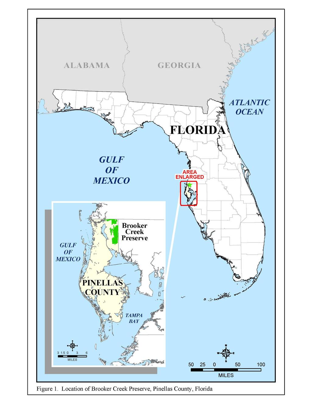
5 EXECUTIVE SUMMARY Brooker Creek Preserve is approximately 8,000 acres and is located in the northeast corner of Pinellas County (PC). It is the largest remaining natural open space in this highly urbanized county. Brooker Creek Preserve (BCP) was established in the early 1990 s by the Pinellas County Board of County Commissioners (BCC) for the conservation, protection and restoration of native wildlife habitats. It provides flood storage within its wetlands and creek floodplains, maintains natural groundwater recharge, and protects the Lake Tarpon Watershed. It was also created for residents to experience, understand, and enjoy native Florida through compatible resource-based recreation and programs at the Brooker Creek Preserve Environmental Education Center (BCPEEC). The Pinellas County Department of Environmental Management s Environmental Lands Division (DEM/ELD) manages the Preserve including 1,621 acres owned by the Southwest Florida Water Management District (SWFWMD). Funds from the voterapproved Penny for Pinellas Endangered Lands Fund, Florida Communities Trust s (FCT) P2000/Florida Forever Grant Program, and donations allowed acquisition of 2,716 additional acres of Preserve lands. The remaining 3,623 acres were purchased in the 1980 s by Pinellas County Utilities (PCU) for wellfield production and protection. When the Preserve was established these acres were included within the boundary. An understanding between DEM and PCU was that these acres could still be used, as needed, for purposes related to potable water supply. Proposed changes to the Future Land Use Map category Preservation-Resource Management (P-RM) and zoning districts P-RM and Preservation/Conservation (P/C) will define PCU uses and their locations within the Preserve. There are currently several water distribution pipes, production and monitoring wells and various other infrastructure related to potable water supply within the Preserve. Access is provided to PCU and Tampa Bay Water for replacement, repair and monitoring of these facilities. Progress Energy (PE) has several transmission line easements in various locations within the Preserve that were established prior to the establishment of Brooker Creek Preserve. The power company also owns a 177-acre, 300- to 500-foot-wide transmission corridor that bisects part of the Preserve. Although this is not officially part of the Preserve it provides valuable wildlife habitat and a connection between the west and east sides of the Preserve. PC and PE work cooperatively when any work is needed within these powerline corridors. Several policy, guiding, and contractual documents govern the management and use of the Preserve. Grant contracts between FCT and PC require several natural resource management activities and resource-based recreation facilities on the 569 acres acquired with these funds. The SWFWMD lease intent is the County s use of the property for the purpose and associated responsibilities of essential site management, habitat enhancement, and resource-based recreational activities. The PC Ordinance provides rules and regulations controlling the public s use of PC preserves and i
6 management areas. Most of the Preserve falls under the wellhead protection zone and therefore, falls under the regulations of the Wellhead Protection Ordinance. This ordinance provides information on the prohibition or restriction of all non-residential activities that use, handle, produce, dispose, and/or store regulated substances within the protected zone. Several PC resolutions were adopted to amend the boundaries of the Preserve as new parcels were acquired along with Resolution No that reestablished the commitment of the BCC to the protection and management of BCP and wellfield areas within the boundaries. The BCC Strategic Plan and Strategic Business Plan provides overall Board direction on a number of priority issues including protection and use of preserve lands. The Preserve management plan implements the goals, objectives, and policies of many elements of the County s Comprehensive Plan. DEM/ELD is currently drafting a five-year strategic plan. And, finally, the PC Recreation, Open Space and Culture System Master Plan (September 2005) provides guidance on the use and protection of regional parks and preserves. The Preserve is approximately 55% uplands and 45% wetlands. Upland areas are predominantly pine flatwoods with some areas of hammocks, sandhills, and disturbed plant communities. Wetlands consist of shallow, braided channels of Brooker Creek as well as bottomland hardwoods, cypress domes and strands, hardwood and mixed wetland forests, borrow pit lakes, and marshes/wet prairies. There are currently 626 verified floral species, of which 12 are State-listed. Also verified are 20 mammal, 196 bird, 60 herpetofaunal and 194 invertebrate species. Seventeen of the vertebrate wildlife species are State-listed. The primary focus of the Preserve is the management of its natural resources. With the use of the Pinellas County Wildlands Fire Team and assistance from Florida s Division of Forestry (FDOF) the established prescribed burn program will continue to restore and maintain the health of these fire-dependent ecosystems and help reduce the risk of high intensity wildfires. Restoration of hydrology and disturbed sites back to their natural conditions is another focus for the Preserve. To date, 19 sites have been restored, totaling over 120 acres. Twenty additional projects totaling over 630 acres are targeted for restoration work. Fire suppression has created areas of unhealthy dense stands of pine trees and thick understory vegetation. Timber thinning was used within 130 acres of pine flatwoods as a way to decrease tree density. Another method used to treat overgrown, fire-suppressed areas is mechanical thinning of the understory. Over 200 acres have been roller-chopped or hydro-axed to help restore plant biodiversity. Invasive exotic flora and fauna control, species inventories and security measures (fencing, signage, and law enforcement) continue. Additionally, potential future acquisition of adjacent lands (including the Wilde Trust and CSX properties) not only would expand the Preserve and protect open space, but would also support the goals of the County s Comprehensive Plan and the ELD strategic plan. ii
7 A secondary focus of the Preserve is to provide resource-based recreational opportunities that are compatible with the management and protection of the natural resources. There are currently two hiking trails, two horseback riding trails, and a primitive group camping site. Future resource-based recreational facilities include a potential hiking trail in the Oldsmar area and canopy walkway with an observation tower and amenities associated with the FCT grant contract requirements for Brooker-Anclote Corridor and Four Lakes Hammock areas (i.e. hiking trails, boardwalks, observation platform, fishing docks, canoe/kayak landing, picnic pavilion, and restroom). The Brooker Creek Preserve Environmental Education Center s (BCPEEC) threebuilding complex opened in June Through exhibits, educational programs, and guided hikes, visitors can experience, discover, and better understand the connections between people and the land. Programs offered at the BCPEEC by staff and various partners help visitors make informed decisions about natural and cultural resources and identify personal actions they can take to reduce negative impacts on natural resources. Facilities at the BCPEEC can also be rented through short-term facility license agreements. iii
8 Brooker Creek Preserve Management Plan 2008 Update TABLE OF CONTENTS EXECUTIVE SUMMARY i LIST OF FIGURES.... viii LIST OF TABLES AND CHARTS... ix LIST OF PREPARERS.. x INTRODUCTION.. 1 SECTION 1. GENERAL INFORMATION Mission Statements History General Lands North of Keystone Lands South of Keystone Ownership General Long-Range Target Conditions Objectives Easements Adjacent Land Use Florida Communities Trust Southwest Florida Water Management District A Five-Year Strategic Plan for Pinellas County Government - Department of Environmental Management - Environmental Lands Division Board of County Commissioners Strategic Plan & Strategic Business Plan Ordinance Pinellas County Recreation, Open Space and Culture System Master Plan (September 2005) Resolutions 1-19 Pinellas County Comprehensive Plan The Future Land Use Map and Zoning Current Proposed Wellhead Protection Ordinance Pinellas County Utilities City of Oldsmar Progress Energy Non-Recreational Infrastructure 1-29 Preserve Operational Related Wellfield and Water Supply Related Miscellaneous Archaeological and Cultural Resources Staffing iv
9 Volunteer Program Friends of Brooker Creek Preserve, Inc Concessions, Leases, Licenses, Rentals, and Permits 1-34 SECTION 2. NATURAL RESOURCES General Topography Soil Types Xeric Soils 2-4 Mesic Soils Hydric Soils. 2-5 Water Resources Plant Communities and Cover Types. 2-6 Listed Species 2-13 Invasive Exotic Species 2-13 Flora 2-13 Fauna SECTION 3. NATURAL RESOURCE MANAGEMENT Restoration 3-1 Completed Restoration Projects Future Restoration Projects. 3-9 Wetland Mitigation Prescribed Burning Mechanical Vegetation Thinning 3-18 Invasive Exotic Species Control Floral Faunal 3-20 Timber Thinning Species Inventories Natural Communities Mapping Research and Monitoring 3-22 Land Acquisition Security Fencing Signage Law Enforcement Funding Sources Estimated Schedule Cost Estimates SECTION 4. PUBLIC RECREATION 4-1 Existing Recreation Facilities Hiking Trails 4-2 Horseback Riding Trails Four Lakes Hammock Primitive Group Camp Site. 4-6 Potential Improvements to Existing Recreation Facilities 4-10 Hiking Trails 4-10 Horseback Riding Trails Four Lakes Hammock Primitive Group Camp Site Potential Future Recreation Facilities 4-11 v
10 Hiking Trail in Oldsmar Area Brooker-Anclote Corridor Four Lakes Hammock Canopy Walkway 4-21 Funding Sources Estimated Schedule Cost Estimates Recreational Facility Maintenance SECTION 5. EDUCATIONAL PROGRAM Mission Statements Brooker Creek Preserve Environmental Education Center. 5-1 REFERENCES R-1 APPENDIX 1. APPENDIX 2. APPENDIX 3. Oldsmar Recreation Easement Florida Communities Trust Fund Southwest Florida Management District Lease Agreement APPENDIX 4. BCC Strategic Plan & Strategic Business Plans APPENDIX 5. Ordinance APPENDIX 6. APPENDIX 7. APPENDIX 8. APPENDIX 9. Pinellas County Recreation, Open Space and Culture System Master Plan Resolutions Pinellas County Comprehensive Plan Future Land Use Map & Zoning APPENDIX 10. Wellhead Protection Ordinance APPENDIX 11. Agreement between Pinellas County, Florida and the Friends of Brooker Creek Preserve, Inc. APPENDIX 12. Trinity Oaks Property Owner s Association, Inc. License Agreement APPENDIX 13. Florida Division of Forestry Lease Agreement APPENDIX 14. Listed Floral & Faunal Species Found at Brooker Creek Preserve APPENDIX 15. Invasive Exotic Flora at Brooker Creek Preserve vi
11 APPENDIX 16. Bissett Method of Direct Seeding Restoration APPENDIX 17. Sample Burn Prescription APPENDIX 18. Florida Exotic Pest Plant Council List APPENDIX 19. Brooker Creek Preserve Floral Species List APPENDIX 20. Brooker Creek Preserve Faunal Species List vii
12 LIST OF FIGURES Figure 1. Location of Brooker Creek Preserve, Pinellas County, Florida Figure 2. Pinellas County Environmental Lands.. 3 Figure Brooker Creek Preserve Boundary... 4 Figure Brooker Creek Preserve with Privately-Owned Wilde Property Figure 5. Brooker Creek Preserve and the Eldridge-Wilde Wellfield Figure 6. Sall s Dairy Tract Figure 7. North Brooker Creek Preserve Infrastructure Figure 8. Brooker Creek Preserve Ownership Figure 9. City of Oldsmar Recreation Easement Figure 10. Brooker Creek Preserve Adjacent Land Use Figure 11. Brooker Creek Preserve Florida Communities Trust Fund Grant Lands Figure 12. Southwest Florida Water Management District Lands Figure 13. Brooker Creek Preserve Future Land Use and Zoning Designations Figure 14. Brooker Creek Preserve Proposed Future Land Use Map Figure 15. Wellhead Protection Zone Figure 16. Brooker Creek Preserve within the City of Oldsmar Figure 17. Progress Energy Owned Corridor and Easements within Brooker Creek Preserve Figure 18. Brooker Creek Preserve Non-Recreational Infrastructure Figure 19. Topographic Map of Brooker Creek Preserve Figure 20. Brooker Creek Preserve Soils. 2-3 Figure 21. Brooker Creek Preserve Drainage Basins Figure 22. Historic Flow within Brooker Creek Preserve Figure 23. Brooker Creek Preserve Natural Plant Communities Figure 24. Brooker Creek Preserve Completed Restoration Sites Figure 25. Brooker Creek Preserve Future Restoration Sites Figure 26. Brooker Creek Preserve Potential Acquisitions Figure 27. Brooker Creek Preserve Existing Recreation Figure 28. Brooker Creek Preserve - The Friends Trail Figure 29. Brooker Creek Preserve - Wildlands Hiking Trails Figure 30. Brooker Creek Preserve - Scenic Horse Trail Figure 31. Brooker Creek Preserve - Exercise Horse Trail Figure 32. Brooker Creek Preserve - Four Lakes Hammock Area Figure 33. Brooker Creek Preserve - Wildlands Hiking Trails Gradework Figure 34. Brooker Creek Preserve - Wildlands Hiking Trails Picnic Shelter Path Improvements Figure 35. Brooker Creek Preserve Original Route of the Scenic Horse Trail Figure 36. Brooker Creek Preserve Potential Oldsmar Area Hiking Trail Figure 37. Brooker-Anclote Corridor Conceptual Future Recreation Figure 38. Brooker Creek Preserve Four Lakes Hammock Area Future Recreation Figure 39. Brooker Creek Preserve Four Lakes Hammock Area Conceptual Future Recreation Figure 40. Brooker Creek Preserve Proposed Canopy Walkway 4-21 Figure 41. Brooker Creek Preserve Environmental Education Center viii
13 LIST OF TABLES AND CHARTS Table 1. Brooker Creek Preserve Ownership Table 2. Pinellas County Utilities Present and Potential Uses Within Brooker Creek Preserve Chart 1. ELD Organizational Structure - Beginning FY Table 3. Volunteer Hours Worked at Brooker Creek Preserve, October 2005 September Appendices Tables: Listed Flora & Fauna Species Found at Brooker Creek Preserve Appendix 14 Brooker Creek Preserve Invasive Exotic Flora....Appendix 15 Brooker Creek Preserve Floral Species List.Appendix 19 Brooker Creek Preserve Faunal Species List Appendix 20 ix
14 LIST OF PREPARERS Lisa A. Baltus, Environmental Program Manager, Environmental Lands Division Christopher S. Helt, Environmental Specialist, Environmental Lands Division Marcia M. Colby, Departmental GIS Application Specialist, Environmental Lands Division Dr. Steven J. Harper, Program Coordinator, Environmental Lands Division. Holly Johnson-Shiralipour, Education Center Manager, Environmental Lands Division Reviewers: Pinellas County Department of Environmental Management Pinellas County Department of Environmental Management s Environmental Lands Division Pinellas County Utilities Pinellas County Board of County Commissioners Pinellas County Environmental Science Forum Southwest Florida Water Management District Florida Communities Trust Progress Energy, Inc. The Friends of Brooker Creek Preserve, Inc. Florida Division of Forestry City of Oldsmar Parks, Recreation & Cultural Affairs x
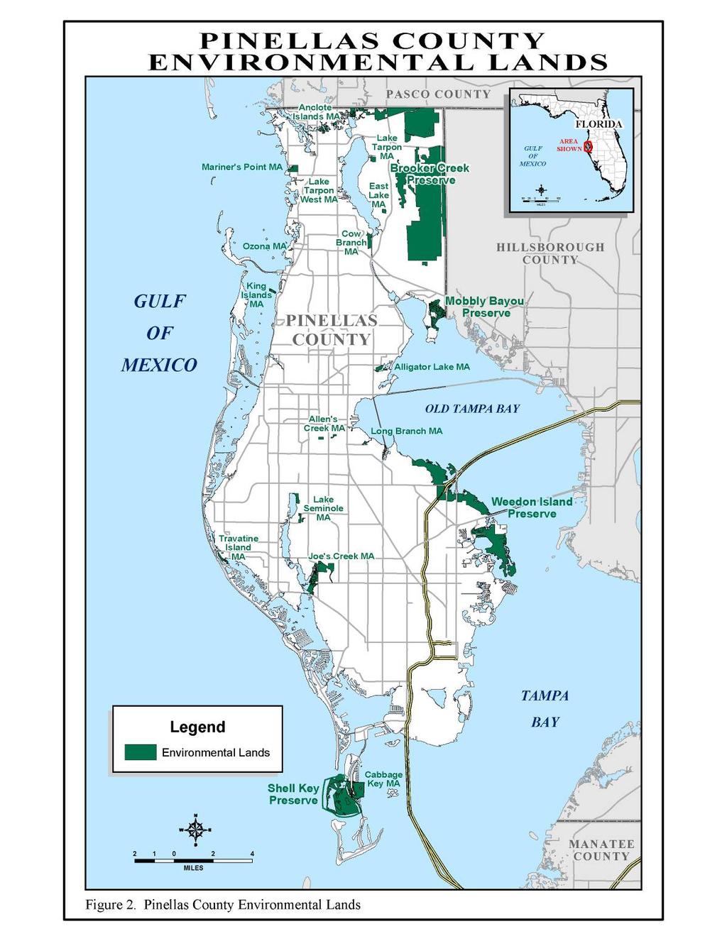
15 INTRODUCTION The Pinellas County Board of County Commissioners established Brooker Creek Preserve (BCP) in the early 1990 s (Figure 1). The Preserve was created for the conservation, protection and restoration of native wildlife habitats. It provides flood storage within the wetlands and creek floodplains, maintains natural groundwater recharge, and provides protection of the Lake Tarpon Watershed. It was also created for residents to experience, understand, and enjoy native Florida through compatible resource-based recreation and programs at the Brooker Creek Preserve Environmental Education Center (BCPEEC). Pinellas County (PC) is approximately 180,000 acres and is the most densely populated county in the state of Florida. At approximately 8,000 acres, Brooker Creek Preserve is by far the largest remaining natural open space in this highly urbanized landscape making it an important regional natural resource (Figure 2). The Preserve s boundaries are roughly the Pasco County line to the north, the Hillsborough County line to the east, the Progress Energy s transmission line right-of-way on the south, and numerous subdivisions (east of East Lake Road) to the west. North of Trinity Boulevard, the Preserve extends westward to the Anclote River. The Preserve lands are owned by Pinellas County and the Southwest Florida Water Management District (SWFWMD). Management of Brooker Creek Preserve falls under the jurisdiction of the PC Department of Environmental Management s Environmental Lands Division (DEM/ELD). ELD is also responsible for management of 18 other preserves and management areas. Including Brooker Creek Preserve, these lands total over 15,000 acres. The Preserve is approximately 55% uplands and 45% wetlands. The upland areas are predominantly pine flatwoods with some areas of hammocks, sandhills, and disturbed plant communities. The wetlands consist of shallow braided channels of Brooker Creek, bottomland hardwoods, cypress domes and strands, hardwood and mixed wetland forests, borrow pit lakes, and marshes/wet prairies. The first management plan was written in 1993 by a team of consultants lead by the University of South Florida. At that time there were several privately owned parcels included within the boundary of the Preserve. Some have been acquired; however, the Wilde Trust and Progress Energy properties remain under private ownership (Figure 3) and are not included within the current Preserve boundary. Since 1993, approximately 2,100 additional acres were acquired, a prescribed burn program established, several upland and wetland restoration projects completed, an exotic control program put in place, numerous dumpster loads of trash removed, long-term ecological data collected, two areas of public hiking trails opened, two horseback riding trails established, the BCPEEC was built and opened, the Friends of Brooker Creek Preserve, Inc. organized, the Environmental Lands Unit of the PC Sheriff s Office were contracted, and the Environmental Lands Division was created with a corps of professional staff and volunteers. 1
16 2
17 3
18 Page left blank for Figure 3. 4
SECTION 4. PUBLIC RECREATION
 SECTION 4. PUBLIC RECREATION Brooker Creek Preserve is the largest remaining tract of wild land in Pinellas County and contains many species not found anywhere else in the County. As such, these wild lands
Pinellas County Environmental Lands
 Pinellas County Environmental Lands In addition to traditional parks and recreation facilities, Pinellas County owns and manages a system of environmental lands that provides specialized resource-based
Conservation Lands. Conservation Lands Advisory Committee October 19, 2005
 Conservation Lands Advisory Committee October 19, 2005 Roland DeBlois Chief of Environmental Planning & Code Enforcement Community Development Department Beth Powell Conservation Lands Manager Parks Division
Conservation Area Management Statement
 Conservation Area Management Statement Miller Creek Wildlife Area Resolution #: Approval: Issue Date: Date of Last Revision: Table of Contents 1. Purpose....... 1 2. Property Description...... 1 2.1. Legal
3.0 EXISTING PARK & RECREATION SPACE
 3.0 EXISTING PARK & RECREATION SPACE TOWN PARK & RECREATION SPACE An inventory of current parks and recreation area in the Town of Cedarburg is shown in Table 3. These areas total roughly 381.89 acres.
Chapter 2: Summary of Existing Open Space System
 Chapter 2: Summary of Existing Open Space System In 1976, the Wake County Board of Commissioners established the Wake County Parks and Recreation Department in order to provide park facilities and programs
2. Goals and Policies. The following are the adopted Parks and Trails Goals for Stillwater Township:
 D. PARKS AND TRAILS 1. Introduction Stillwater Township s population is relatively low, with most residents living on rural residences on large lots. The need for active park space has been minimal in
MANAGEMENT DIRECTION STATEMENT June, 1999
 Thompson River District MANAGEMENT DIRECTION STATEMENT June, 1999 for Roche Lake Provincial Park Ministry of Environment Lands and Parks BC Parks Division Table of Contents I. Introduction A. Setting
METROPOLITAN COUNCIL 390 North Robert Street, St. Paul, MN Phone (651) TDD (651)
 TDD (651)") DATE: March 27, 2012 METROPOLITAN COUNCIL 390 North Robert Street, St. Paul, MN 55101 Phone (651) 602-1000 TDD (651) 291-0904 TO: Metropolitan Parks and Open Space Commission FROM: Arne Stefferud, Planning
DATE: March 27, 2012 METROPOLITAN COUNCIL 390 North Robert Street, St. Paul, MN 55101 Phone (651) 602-1000 TDD (651) 291-0904 TO: Metropolitan Parks and Open Space Commission FROM: Arne Stefferud, Planning
Wallace Falls State Park Classification and Management Planning Stage 3 Preliminary Recommendations July 18, 2018 Sultan City Hall
 Wallace Falls State Park Classification and Management Planning Stage 3 Preliminary Recommendations July 18, 2018 Sultan City Hall Thanks for coming! This document contains State Parks preliminary recommendations
Florida Department of Environmental Protection Division of Recreation and Parks
 Florida Department of Environmental Protection Division of Recreation and Parks Land Edward Ball Wakulla Springs State Park Introduction Edward Ball Wakulla Springs State Park is a 6,055.2-acre public
Continental Divide National Scenic Trail Legislative History and Planning Guidance
 Continental Divide National Scenic Trail Legislative History and Planning Guidance Legislation, Policy, and Direction Regarding National Scenic Trails The National Trails System Act, P.L. 90-543, was passed
Florida Department of Environmental Protection Division of Recreation and Parks
 Florida Department of Environmental Protection Division of Recreation and Parks Land Honeymoon Island State Park Introduction Honeymoon Island State Park is a 2,810.16-acre public outdoor recreation and
Understanding the caring capacity of the visitor experience Provide facilities to support a high level user experience Address visual quality through
 Understanding the caring capacity of the visitor experience Provide facilities to support a high level user experience Address visual quality through recreation ecological restoration opportunities Collaboration
APPENDIX. Alberta Land Stewardship Act AMENDMENTS TO THE SOUTH SASKATCHEWAN REGIONAL PLAN
 APPENDIX Alberta Land Stewardship Act AMENDMENTS TO THE SOUTH SASKATCHEWAN REGIONAL PLAN 1 All references to Alberta Environment and Sustainable Resource Development, Environment and Sustainable Resource
Decision Memo Ice Age Trail Improvement (CRAC 37)
") Decision Memo Ice Age Trail Improvement (CRAC 37) U.S. Forest Service Chequamegon-Nicolet National Forest, Medford-Park Falls Ranger District Taylor County, Wisconsin T32N, R2W, Town of Grover, Section
Decision Memo Ice Age Trail Improvement (CRAC 37) U.S. Forest Service Chequamegon-Nicolet National Forest, Medford-Park Falls Ranger District Taylor County, Wisconsin T32N, R2W, Town of Grover, Section
Bayview Escarpment. Interim Management Statement
 Bayview Escarpment Interim Management Statement Bayview Escarpment Provincial Nature Reserve Interim Management Statement January 15, 1995 REGIONAL DIRECTOR'S APPROVAL STATEMENT This Interim Management
Yard Creek Provincial Park. Management Plan
 Yard Creek Provincial Park Management Plan Draft January 2010 Yard Creek Provincial Park Management Plan Approved by: telàlsemkin/siyam/chief Scott Benton Bill Williams Squamish Executive Director ation
DRAFT GENERAL IMPLEMENTATION PLAN AND SPECIFIC IMPLEMENTATION PLAN MIDDLETON MUNICIPAL AIRPORT MOREY FIELD. Revised 12/12/03
 DRAFT GENERAL IMPLEMENTATION PLAN AND SPECIFIC IMPLEMENTATION PLAN MIDDLETON MUNICIPAL AIRPORT MOREY FIELD Revised 12/12/03 As recommended for approval by the Plan Commission General Project Description
As outlined in the Tatshenshini-Alsek Park Management Agreement, park management will:
 Management Strategy General Strategy The priority management focus for the park is to ensure that its internationally significant natural, cultural heritage and recreational values are protected and that
David Magney Environmental Consulting
 David Magney Environmental Consulting DELINEATION OF JURISDICTIONAL WATERS AND RIPARIAN HABITATS FOR LYONS CANYON RANCH, NEWHALL, CALIFORNIA Prepared for: UNITED STATES ARMY CORPS OF ENGINEERS and CALIFORNIA
Dungeness Recreation Area County Park Master Plan
 Dungeness Recreation Area County Park Public Outreach Meeting October 10, 2007 Project Overview USFWS Site Dungeness Recreation Area County Park Meeting Objectives: Re-Introduce project; provide status
Northeast Quadrant Distinctive Features
 NORTHEAST QUADRANT Northeast Quadrant Distinctive Features LAND USE The Northeast Quadrant includes all the area within the planning area that is east of Interstate 5 and to the north of State Route 44.
I. PREFACE II. THE PARTNERSHIP
 I. PREFACE This document is the "local" plan for the management of the Appalachian Trail in Maine from Maine Highway 26 in Grafton Notch to the summit of Katahdin. It is a part (the other being the Appalachian
LOCAL PLAN FOR THE MANAGEMENT OF THE APPALACHIAN TRAIL IN MAINE. (GRAFTON NOTCH TO KATAHDIN) 1 January 2013 (Revised 5 February 2014)
 1 January 2013 (Revised 5 February 2014)") LOCAL PLAN FOR THE MANAGEMENT OF THE APPALACHIAN TRAIL IN MAINE (GRAFTON NOTCH TO KATAHDIN) 1 January 2013 (Revised 5 February 2014) The Appalachian Trail is a way, continuous from Katahdin in Maine to
LOCAL PLAN FOR THE MANAGEMENT OF THE APPALACHIAN TRAIL IN MAINE (GRAFTON NOTCH TO KATAHDIN) 1 January 2013 (Revised 5 February 2014) The Appalachian Trail is a way, continuous from Katahdin in Maine to
Approval Statement. Brian Pfrimmer, Central Zone Manager Ontario Parks
 Approval Statement I am pleased to approve this Interim Management Statement for Dividing Lake Provincial Nature Reserve. This Nature Reserve contains biological features of provincial significance and
MASTER PLAN EXECUTIVE SUMMARY
 Biscuit Run State Park Scottsville Road (State Route 20) Charlottesville, VA 22902 Biscuit Run State Park MASTER PLAN EXECUTIVE SUMMARY Department of Conservation and Recreation Division of Planning and
OMINEACA PROVINCIAL PARK
 OMINEACA PROVINCIAL PARK AND PROTECTED AREA PURPOSE STATEMENT AND ZONING PLAN March 2003 OMINECA PROVINCIAL PARK AND PROTECTED AREA Purpose Statement and Zoning Plan Omineca Park and Omineca Protected
Finding aid of the Central Files
 http://oac.cdlib.org/findaid/ark:/13030/c8g165z3 No online items Finding aid of the Central Files Sonia Collazo Sequoia & Kings Canyon National Parks 47050 Generals Highway Three Rivers, CA 93271-9700
112th CONGRESS. 1st Session H. R. 113 IN THE HOUSE OF REPRESENTATIVES
 HR 113 IH 112th CONGRESS 1st Session H. R. 113 To provide for additions to the Cucamonga and Sheep Mountain Wilderness Areas in the Angeles and San Bernardino National Forests and the protection of existing
BRACEVILLE NATURE PRESERVE Introductions History Present Conditions Future Development Plans Implementation Strategies Statistics
 BRACEVILLE NATURE PRESERVE Introductions History Present Conditions Future Development Plans Implementation Strategies Statistics Introduction Braceville Nature Preserve is one of MetroParks largest preserves.
City of Durango 5.8 FUNDING TRAILS DEVELOPMENT
 5.8 FUNDING TRAILS DEVELOPMENT The City has been successful in establishing dedicated local funding sources as well as applying for grants to develop the City s trail system, having received nearly $2.4
April 10, Mark Stiles San Juan Public Lands Center Manager 15 Burnett Court Durango, CO Dear Mark,
 Mark Stiles San Juan Public Lands Center Manager 15 Burnett Court Durango, CO 81301 Dear Mark, We are pleased to offer the following comments on the draft San Juan Public Lands Center management plans
Whitemouth Falls Provincial Park. Draft Management Plan
 Whitemouth Falls Provincial Park Draft Management Plan Whitemouth Falls Provincial Park Draft Management Plan Table of Contents 1. Introduction... 3 2. Park History... 3 3. Park Attributes... 4 3.1 Natural...
Nakina Moraine Provincial Park. Interim Management Statement. Ontario. Ministry of Natural Resources
 Nakina Moraine Provincial Park Interim Management Statement Ontario Ministry of Natural Resources 1999, Queen's Printer for Ontario Printed in Ontario, Canada Additional copies of this publication can
BA Collaborators. Driftless Area Initiative The Prairie Enthusiasts Trout Unlimited TNC TCF Natural Resources Foundation of Wisconsin
 BA Collaborators Driftless Area Initiative The Prairie Enthusiasts Trout Unlimited TNC TCF Natural Resources Foundation of Wisconsin The mission of the of the Blufflands Alliance is to actively conserve
Moraine Valley Community College Campus Tree Care Plan Table of Contents
 Moraine Valley Community College Campus Tree Care Plan 2016-2021 Table of Contents I. CAMPUS TREE CARE PLAN PURPOSE:... 1 II. RESPONSIBLE DEPARTMENT... 1 III. THE CAMPUS TREE ADVISORY COMMITTEE... 1 IV.
COASTAL CONSERVANCY. Staff Recommendation December 2, 2004 COYOTE HELLYER COUNTY PARK BAY AREA RIDGE TRAIL
 COASTAL CONSERVANCY Staff Recommendation December 2, 2004 COYOTE HELLYER COUNTY PARK BAY AREA RIDGE TRAIL File No. 04-057 Project Manager: Amy Hutzel RECOMMENDED ACTION: Authorization to disburse up to
MCARTHUR SWAMP PLANNING UNIT Pit-McCloud River Watershed
 Existing Conditions & Uses Overview Spring-fed lake and rivers; valuable grazing lands and important waterfowl area Planning unit provides the only public access to Ahjumawi Lava Springs State Park 7,596
THOMAS A. SWIFT METROPARK Introductions History Present Conditions Future Development Plans Implementation Strategies Statistics
 THOMAS A. SWIFT METROPARK Introductions History Present Conditions Future Development Plans Implementation Strategies Statistics Introduction As an open meadow park positioned along the Mahoning River,
MANAGEMENT DIRECTION STATEMENT June, 1999
 Thompson River District MANAGEMENT DIRECTION STATEMENT June, 1999 for Clearwater River Corridor (Addition to Wells Gray Park) Ministry of Environment Lands and Parks BC Parks Division ii Table of Contents
Blueways: Rivers, lakes, or streams with public access for recreation that includes fishing, nature observation, and opportunities for boating.
 Parks, Open Space and Trails PRINCE WILLIAM COUNTY 2008 COMPREHENSIVE PLAN TRAILS PLAN CONTENTS The components of the trails plan are: Intent Definitions Goals, Policies, and Action Strategies Trails Map
Conservation Partners for the National Reserve System Program: a Western NSW focus
 Conservation Partners for the National Reserve System Program: a Western NSW focus Cooper, N. 1, Webber, L. 2, Nicolson, K. 3 1 Department of Environment, Climate Change and Water NSW, PO Box 788 Broken
Fossil Creek Wild & Scenic River Comprehensive River Management Plan Forest Service Proposed Action - details March 28, 2011
 Fossil Creek Wild & Scenic River Comprehensive River Management Plan Forest Service Proposed Action - details March 28, 2011 Primary Goals of the Proposed Action 1. Maintain or enhance ORVs primarily by
Pembina Valley Provincial Park. Draft Management Plan
 Pembina Valley Provincial Park Draft Management Plan 2 Pembina Valley Provincial Park Table of Contents 1. Introduction... 3 2. Park History... 3 3. Park Attributes... 3 3.1 Natural... 3 3.2 Recreational...
Rule Governing the Designation and Establishment of All-Terrain Vehicle Use Trails on State Land
 Rule Governing the Designation and Establishment of All-Terrain Vehicle Use Trails on State Land 1.0 Authority 1.1 This rule is promulgated pursuant to 23 V.S.A. 3506. Section 3506 (b)(4) states that an
ISLAND PARK MANAGEMENT PLAN AND GUIDELINES
 ISLAND PARK MANAGEMENT PLAN AND GUIDELINES - 2015 Introduction Island Park was a sand dune on the edge of Lake Huron 12,000 years ago. As the lake receded, it left a river channel, the Thunder Bay River.
Map 1.1 Wenatchee Watershed Land Ownership
 Map 1.1 Wenatchee Watershed Land Ownership Map 1.1 Wenatchee Watershed Land Ownership The Wenatchee watershed lies in the heart of Washington state in Chelan County. Just larger than the state of Rhode
 March 25, 1994 To: Re: MEMO TO FILE MINOR AMENDMENT - PINERY PROVINCIAL PARK MANAGEMENT PLAN The following paragraph from page 5 of the Pinery Provincial Park Management Plan (ISBN 0-7729-0290-9) lnsects
The Chu property is a 6.57 acre parcel located in the Town of Superior on the west side of McCaslin Boulevard. In 2014, the Town of Superior acquired
 1 The Chu property is a 6.57 acre parcel located in the Town of Superior on the west side of McCaslin Boulevard. In 2014, the Town of Superior acquired the Chu property for open space with a contribution
Hawke s Bay Regional Parks Network. Pekapeka Regional Park Individual Park Plan
 Hawke s Bay Regional Parks Network Pekapeka Regional Park Individual Park Plan 2015-2024 Hawke s Bay Regional Council 159 Dalton Street Private Bag 6006 Napier 4110 Hawke s Bay New Zealand Telephone: 0800
AMENDMENT #230 TO THE OFFICIAL PLAN OF THE TOWNSHIP OF KING PLANNING AREA
 AMENDMENT #230 TO THE OFFICIAL PLAN OF THE TOWNSHIP OF KING PLANNING AREA Oak Ridges Moraine Conservation Plan Amendment to Township of King Official Plan Amendment #23 (Hamlet Secondary Plan) October
ETOBICOKE CREEK NORTH TRAIL PROJECT. May 18, 2017 at Michael Power High School 105 Eringate Drive, Etobicoke ON M9C 3Z7
 ETOBICOKE CREEK NORTH TRAIL PROJECT May 18, 2017 at Michael Power High School 105 Eringate Drive, Etobicoke ON M9C 3Z7 1 Purpose of Open House The purpose of today s open house is to present the design
Parkland County Municipal Development Plan Amendment Acheson Industrial Area Structure Plan
 Parkland County Municipal Development Plan Amendment Acheson Industrial Area Structure Plan New Plan Acheson Industrial Area Structure Plan Amendment Parkland County Municipal Development Plan Board Reference
Flow Stand Up Paddle Board Parkway Plan Analysis
 Regional Parks Department Jeffrey R. Leatherman, Director County of Sacramento Divisions Administration Golf Leisure Services Maintenance Rangers Therapeutic Recreation Services Flow Stand Up Paddle Board
NAVAJO COMMUNITY PLAN
 NAVAJO COMMUNITY PLAN Prepared by the NAVAJO COMMUNITY PLANNERS and THE CITY OF SAN DIEGO City of San Diego Planning Department 202 C Street, MS 4A San Diego, CA 92101 Printed on recycled paper. This information,
Creating a User-Driven Long-Distance OHV Trail Through Partnering
 Joseph Raffaele Outdoor Recreation Planner U.S. Bureau of Land Management Yuma, Arizona Creating a User-Driven Long-Distance OHV Trail Through Partnering BLM is a multiple-use land management agency within
Summary of prescribed fires in Prince Albert National Park 2015
 Summary of prescribed fires in Prince Albert National Park 2015 Prince Albert National Park conducted four controlled fires in spring 2015, plus an additional fire in October. Fuel Management for Hazard
STOWER SEVEN LAKES STATE RECREATION TRAIL POLK COUNTY, WISCONSIN. MASTER PLAN June, 2018
 STOWER SEVEN LAKES STATE RECREATION TRAIL POLK COUNTY, WISCONSIN MASTER PLAN June, 2018 Polk County Environmental Services Committee Kim O Connell-Chairman Brad Olson -Vice Chairman Jim Edgell Doug Route
I. Call to Order. A. Invocation. B. Pledge of Allegiance. Employee Awards. Public Information Update. 1. PIO Update- Page: 6
 Agenda Okaloosa County Board of Commissioners Tuesday, April 16, 2019 8:30 AM Okaloosa County Administration Building In accordance with Section 286.011, Florida Statutes, this meeting was publicly noticed
Preferred Recreation Recommendations Stemilt-Squilchuck Recreation Plan March 2018
 Preferred Recreation Recommendations Stemilt-Squilchuck Recreation Plan March 2018 Below are the recommended recreation ideas and strategies that package together the various recreation concepts compiled
SAN ANTONIO RIVER IMPROVEMENTS PROJECT. April 27, 2009
 SAN ANTONIO RIVER IMPROVEMENTS PROJECT April 27, 2009 1 Project Limits 2 Project Partners City of San Antonio Provides project funding for project amenities (i.e.. Sidewalks, Landscaping, Lighting, etc.)
Silver Lake Park An Environmental Jewel for the Citizens of Prince William County
 Silver Lake Park An Environmental Jewel for the Citizens of Prince William County The Prince William Park Authority Mission Statement states: The Prince William County Park Authority will create quality
MORGAN CREEK GREENWAY Final Report APPENDICES
 APPENDICES MORGAN CREEK GREENWAY Appendix A Photos of Existing Conditions in Trail Corridor Photos of existing conditions Main trail corridor - February 2009 Photos of existing conditions south bank Morgan
Boyne Valley Provincial Park. Interim Management Statement
 Boyne Valley Provincial Park Interim Management Statement January 20, 1995 REGIONAL DIRECTOR'S APPROVAL STATEMENT This Interim Management Statement will provide interim direction for the management of
Partners: Michigan California Timber Company Shasta-Trinity National Forest Pacific Crest Trail Association The Trust for Public Land
 Partners: Michigan California Timber Company Shasta-Trinity National Forest Pacific Crest Trail Association The Trust for Public Land Describe the project location, size, opportunities, and timing. Provide
ANCLOTE COASTAL TRAIL ALTERNATIVES ANALYSIS STUDY
 ANCLOTE COASTAL TRAIL ALTERNATIVES ANALYSIS STUDY PASCO COUNTY MPO JULY 2015 PROJECT OVERVIEW... INTRODUCTION EXECUTIVE SUMMARY CONTEXT... TAMPA BAY AREA, PINELLAS, & PASCO COUNTY S MULTI-USE TRAIL PLANS
MANAGEMENT DIRECTION STATEMENT
 Skeena District MAAGEMET DIRECTIO STATEMET July, 2000 for Driftwood Canyon Provincial Park Ministry of Environment Lands and Parks BC Parks Division i Table of Contents Driftwood Canyon Park Approvals
IOWA ORNITHOLOGISTS' UNION - Birding Sites in Dallas County
 IOWA ORNITHOLOGISTS' UNION - Birding Sites in Dallas County Printed on 7/19/2018 Beaver Bottoms Wetland (restricted) (Important Bird Area) GPS Coordinates:, Ownership: Private (see directions for access)
Prepared by Cathy Quinlan & Brad Hertner Upper Thames River Conservation Authority. For the City of Woodstock
 Prepared by Cathy Quinlan & Brad Hertner Upper Thames River Conservation Authority For the City of Woodstock Burgess Park and Standard Tube Parks in the west end of Woodstock Pittock Reservoir Along the
EAST DON TRAIL ENVIRONMENTAL ASSESSMENT. Community Liaison Committee Meeting #3 July 15, :30 to 8:30 pm Flemingdon Park Library
 EAST DON TRAIL ENVIRONMENTAL ASSESSMENT Community Liaison Committee Meeting #3 July 15, 2013 6:30 to 8:30 pm Flemingdon Park Library Agenda 1. Welcome 2. Housekeeping and Updates a) Housekeeping b) CLC
Business Item No
 Metropolitan Parks and Open Space Commission Meeting date: February 6, 2018 For the Community Development Committee meeting of February 20, 2018 For the Metropolitan Council meeting of February 28, 2018
Town of Oakfield Agricultural and Farmland Protection Plan
 SECTION III COMMUNITY OVERVIEW A. Regional Setting / Location The Town of Oakfield is located in the northwestern portion of Genesee County. Located west of New York's Finger Lakes, the Town is uniquely
AMENDMENT NO. 03 TO THE OFFICIAL PLAN FOR THE TOWNSHIP OF ADJALA-TOSORONTIO OAK RIDGES MORAINE CONSERVATION PLAN
 AMENDMENT NO. 03 TO THE OFFICIAL PLAN FOR THE TOWNSHIP OF ADJALA-TOSORONTIO OAK RIDGES MORAINE CONSERVATION PLAN Adopted by Council July 19 th, 2004 Approved with modifications by the Province of Ontario
Procedure for the Use of Power-Driven Mobility Devices on Mass Audubon Sanctuaries 1 September 17, 2012
 Procedure for the Use of Power-Driven Mobility Devices on Mass Audubon Sanctuaries 1 September 17, 2012 Background As part of Mass Audubon s mission to preserve the nature of Massachusetts for people and
KASKASKIA RIVER NAVIGATION POOL Compartment 12 UNIT 1 Kaskaskia Lock and Dam Lands These lands are now being managed by the Carlyle Lake project
 KASKASKIA RIVER NAVIGATION POOL Compartment 12 UNIT 1 Kaskaskia Lock and Dam Lands These lands are now being managed by the Carlyle Lake project office. Sections 1-4 in this plan present Kaskaskia River
Clearwater Lake Provincial Park. Draft Management Plan
 Clearwater Lake Provincial Park Draft Management Plan Clearwater Lake Provincial Park Draft Management Plan Table of Contents 1. Introduction... 3 2. Park History... 4 3. Park Attributes... 4 3.1 Location/Access...4
Budget Presentation City of Hamilton. January 23, 2018
 Budget Presentation City of Hamilton January 23, 2018 HCA Watershed & 2017 Highlights 2018 Budget Details HCA Land Holdings Acreage - Over 11,000 acres, ~10% of watershed In last decade have significant
Watchorn Provincial Park. Management Plan
 Watchorn Provincial Park Management Plan 2 Watchorn Provincial Park Table of Contents 1. Introduction... 3 2. Park History... 3 3. Park Attributes... 3 3.1 Natural... 4 3.2 Recreational... 4 3.3 Additional
Alternative 3 Prohibit Road Construction, Reconstruction, and Timber Harvest Except for Stewardship Purposes B Within Inventoried Roadless Areas
 Roadless Area Conservation FEIS Summary Table S-1. Comparison of Key Characteristics and Effects by Prohibition Alternative. The effects summarized in this table A would occur in inventoried roadless areas
10/25/2013. What is the SCORP?! 2013 Local Government Survey 2013 Statewide Public Survey Advisory Group Priority Areas Your Suggestions!
 COLORADO OUTDOOR RECREATION TRENDS RESULTS FROM THE SCORP AND STATEWIDE Colorado Outdoor Recreation Resource Partnership September 2013 PRESENTATION What is the SCORP?! 2013 Local Government Survey 2013
Phoenix Habitat Restoration Projects
 Phoenix Habitat Restoration Projects Spur Cross Ranch Cave Creek (Estergard) Regional Tree and Shade Summit March 9, 2010 Desert Riparian Ecosystems Healthy riparian areas like this once existed along
FLORIDA DEPARTMENT OF ENVIRONMENTAL PROTECTION DIVISION OF RECREATION AND PARKS RECREATIONAL CARRYING CAPACITY GUIDELINES
 FLORIDA DEPARTMENT OF ENVIRONMENTAL PROTECTION DIVISION OF RECREATION AND PARKS RECREATIONAL CARRYING CAPACITY GUIDELINES THE SELECTION AND CAPACITY DETERMINATION OF USE SITES Introduction The Division
Business Item No XXX. Proposed Action That the Metropolitan Council approve the Coon Creek Regional Trail Master Plan.
 Business Item No. 2015-XXX Metropolitan Parks and Open Space Commission Meeting date: July 7, 2015 For the Community Development Committee meeting of July 20, 2015 For the Metropolitan Council meeting
Chapter eight. Parks and Recreation. Introduction. Crystal Lake Park District
 Chapter eight Parks and Recreation Introduction One of the indicators of quality of life in a city is the parks and recreation system. The City of Crystal Lake is fortunate to have an excellent parks and
Stephens Rd. Nature Preserve
 Stephens Rd. Nature Preserve History Stephens Road Nature Preserve (SRNP) is a 350-acre nature preserve in Huntersville that comprises nine properties purchased between 1994 and 2008. Parcels included
2030 Comprehensive Plan A Policy Guide to 2030
 2030 Comprehensive Plan A Policy Guide to 2030 Parks and Open Spaces Approved by Board of Commissioners May 26, 2009 Adopted by Board of Commissioners September 7, 2010 Washington County Mission To provide
City of Haslett. City of East Lansing. City of East Lansing
 Central Park North (Nancy L. Moore Park) Lake Park North Expansion White Park Expansion #2 White Park Expansion #1 County East East Haslett East East TF87-212 Acquisition $90,000.00 Park. TF08-138 Acquisition
Environment and Natural Resources Trust Fund 2019 Request for Proposals (RFP)
") Environment and Natural Resources Trust Fund 2019 Request for Proposals (RFP) Project Title: Glacial Edge Trail and Downtown Pedestrian Bridge Category: G. Land Acquisition for Habitat and Recreation ENRTF
Environment and Natural Resources Trust Fund 2019 Request for Proposals (RFP) Project Title: Glacial Edge Trail and Downtown Pedestrian Bridge Category: G. Land Acquisition for Habitat and Recreation ENRTF
Order of the Minister of Environment #39, August 22, 2011 Tbilisi
 Registration Code 360050000.22.023.016080 Order of the Minister of Environment #39, August 22, 2011 Tbilisi On preparatory stages and procedure of the methodology for Elaborating structure, content and
U.S. Army Corps of Engineers Fiscal Year 2013 Handshake Program Application
 U.S. Army Corps of Engineers Fiscal Year 2013 Handshake Program Application Please review instructions before completing application! Corps Lake/Project Name:Rathbun Lake/ North Shore Trail Handshake Proposal
EXECUTIVE SUMMARY PROGRAM DEVELOPMENT REPORT PURPOSE EXISTING SETTING EXPANDING PARKLAND
 EXECUTIVE SUMMARY PROGRAM DEVELOPMENT REPORT PURPOSE As the culmination of the first phase of the master planning process, this Program Development Report creates the framework to develop the Calero County
2009 RIVER TOWN OF THE YEAR AWARD APPLICATION Supplemental Material Images
 2009 RIVER TOWN OF THE YEAR AWARD APPLICATION Supplemental Material Images Our History The earliest record of settlement along the river is in 1854; one of the earliest in Carroll County. About this time
AGENDA ITEM 5 D WAKULLA ENVIRONMENTAL INSTITUTE (WEI) TRAIL FEASIBILITY STUDY
 TRAIL FEASIBILITY STUDY") March 19, 2018 AGENDA ITEM 5 D WAKULLA ENVIRONMENTAL INSTITUTE (WEI) TRAIL FEASIBILITY STUDY TYPE OF ITEM: Action STATEMENT OF ISSUE The Wakulla Environmental Institute (WEI) Trail is one of several trails
March 19, 2018 AGENDA ITEM 5 D WAKULLA ENVIRONMENTAL INSTITUTE (WEI) TRAIL FEASIBILITY STUDY TYPE OF ITEM: Action STATEMENT OF ISSUE The Wakulla Environmental Institute (WEI) Trail is one of several trails
(1) GENERAL POLICIES (2) EXISTING USES
 GENERAL POLICIES (2) EXISTING USES") (1) GENERAL POLICIES (d) (e) The policies of Section 20 shall apply to all lands located within the area shown on Schedule A - Land Use and Roads Plan as Oak Ridges Moraine. Schedule E-1 - Oak Ridges Moraine
(1) GENERAL POLICIES (d) (e) The policies of Section 20 shall apply to all lands located within the area shown on Schedule A - Land Use and Roads Plan as Oak Ridges Moraine. Schedule E-1 - Oak Ridges Moraine
Port Gamble Shoreline Area Conceptual Trail Proposal
 The North Kitsap Trails Association is pleased to be a partner to the Kitsap Forest and Bay Project and assist Kitsap County, Forterra, Olympic Property Group, Great Peninsula Conservancy and the Port
APPENDIX OFFICIAL MAP ORDINANCE OF HAMILTONBAN TOWNSHIP OFFICIAL MAP NARRATIVE
 APPENDIX A OFFICIAL MAP ORDINANCE OF HAMILTONBAN TOWNSHIP OFFICIAL MAP NARRATIVE INTRODUCTION: The Official Map of Hamiltonban Township has been prepared to identify those lands and features that Hamiltonban
Chapter 6: POLICY AND PROCEDURE RECOMMENDATIONS
 Chapter 6 POLICY AND PROCEDURE RECOMMENDATIONS FOR SRRA Below are seven policy elements that should be considered for adoption by the Southwest Regional Recreation Authority of Virginia: 1. Develop strategies
LAKE MERCED November 6, 2013
 LAKE MERCED November 6, 2013 Agenda Welcome and Introductions Harding Road Boathouse Updates Lake Merced Water Level Management Pacific Rod and Gun Club Site Cleanup Community Planning Process for Lake
National Forests and Grasslands in Texas
 United States Department of Agriculture Forest Service National Forests and Grasslands in Texas Sam Houston NF 394 FM 1375 West New Waverly, Texas 77358 Phone 936-344-6205 Dear Friends, File Code: 1950