Wallace Falls State Park Classification and Management Planning Stage 3 Preliminary Recommendations July 18, 2018 Sultan City Hall
|
|
|
- Irene Preston
- 5 years ago
- Views:
Transcription
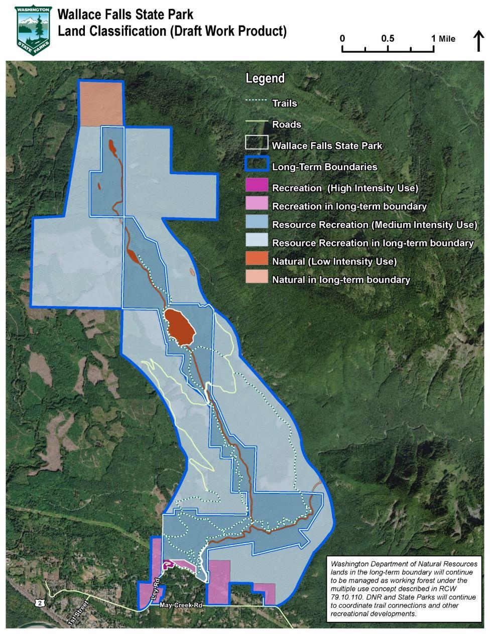
1 Wallace Falls State Park Classification and Management Planning Stage 3 Preliminary Recommendations July 18, 2018 Sultan City Hall Thanks for coming! This document contains State Parks preliminary recommendations for land classification, longterm boundary, and management recommendations. This document takes into account comments received at the November 17, 2017 and March 21, 2018 public meetings and written comments received throughout the planning process. Please provide comments on these preliminary recommendations at the meeting tonight or by Friday August 3. Comment can be submitted to Randy Kline, Project Manager, at randy.kline@parks.wa.gov. For more information visit our Wallace Falls Planning web page at Key Features of the Preliminary Recommendation Looks to provide additional trails and recreation opportunities for hikers, bikers and equestrians Identifies areas where trailhead facilities can be located both on-site and off-site Promotes dispersal of recreation through potential use of the Snohomish County trailhead (the Lawson property) with parking for 50 to 60 vehicles and potential bridge access into the existing trail system north of the Wallace River Identifies additional parking within the park (the Camp Huston in-holding) for either permanent or temporary parking with potential to accommodate up to 100 vehicles Long-term boundary includes DNR, Snohomish County, commercial forest landowners, and private properties Supports the potential for expanded recreation use south, east, and west of the park in coordination with the Department of Natural Resources (DNR) Includes land within the long-term boundary along Ley Road and May Creek Road to coordinate with property owners and City of Gold Bar to improve on-street parking Summary of Core Management Issues Several recurring management issues arose through public meetings and written comments. Preliminary management approaches to these issues as identified by the public and staff include the following: Parking Parking has been and continues to be an important management consideration at Wallace Falls State Park. The park has 108 parking stalls and that limit is often exceeded on week-ends and holidays with as many as 150 vehicles parking outside of the Wallace Falls entrance, especially along Ley Road. Page1
2 This planning process was initiated in part to address these parking issues. Two approaches to the parking issue are proposed. The first is to identify specific parcels in close proximity to the park with the capacity to provide conventional parking facilities to supplement existing in-park parking. Parcel along Ley Road have also been included in the long-term boundary to call out the need to work with property owners on improvements to the current parking situation. The second approach is the use of a van shuttle from an offsite parking location to the park. While this continues to be an option there are a number of issues that make a van shuttle a challenge. Traffic volume on Route 2, especially in the summer, is very heavy and crossing Highway 2 can be difficult. With this in mind a van pick-up site would likely be most successful if located north of Highway 2. This would require an off-site parking lot to accommodate overflow parking. One challenge for a shuttle is the irregularity with which it would likely run making it difficult for a concessionaire or private shuttle company to operate. This document includes a management recommendation that supports use of a shuttle service should one become feasible. Preliminary Recommendation: State Parks proposes to: Include specific parcels in the long-term boundary that can accommodate and support new parking facilities. Include specific parcels along Ley Road in the long-term boundary to work with the City of Gold Bar and property owners along this road which handles the majority of overflow parking. Understand the challenges associated with shuttle service but work with the local stakeholders to support a shuttle if viable. These parcels can be seen in the Long-Term Boundary map below. Coordination with the Department of Natural Resources Wallace Falls State Park is surrounded by a combination of public and private ownerships. The Wild Sky Wilderness area is located east of the park. Generally, adjacent lands located east, west and south of the park are managed by the Department of Natural Resources (DNR). Ownerships on the north end of the park include private commercial forest land owned by Weyerhaeuser Company and Sierra Pacific Industries. Both commercial forest lands and DNR managed lands have been included in the long-term boundary for the park. Reiter Foothills Forest, a DNR managed working forest that includes recreation, is located east, west and south of the park. DNR lands are managed to provide revenue for trust beneficiaries and to provide wildlife habitat. Recreation can occur in these landscapes as a secondary use provided it does not impact the primary objectives. Many opportunities exist to provide trail connections through working landscapes and to coordinate with DNR to provide a range of user experiences in the area. Preliminary Recommendation: Include adjacent DNR lands within the long-term boundary to encourage and facilitate recreation opportunities including non-motorized trail connections between DNR public lands and the park. State Parks seeks to accomplish the purpose of including a property in the long-term boundary in the least burdensome and most advantageous manner. With the surrounding DNR lands this is best achieved through a management agreement that articulates shared recreation goals. Washington State Parks has no plans to acquire any DNR properties in the long-term boundary at present. DNR will continue to manage their lands within the long-term boundary as working forest under the multiple use concept described in RCW These parcels can be seen in the long-term boundary map below. Page2
3 Resource Protection Wallace Falls State Park includes a series of mid-montane lakes and wetland systems that include Shaw, Jay and Wallace Lake. The Wallace River and the North Fork of the Wallace River run through the park. There are two known rare plant species in the park (Gnome plant and Pine-foot) and eight forest communities. In some areas of the park overstocked forest conditions exist. In the long-term boundary on the north end of the park there is a pond and wetland system that supports Shaw, Jay and Wallace Lake that are also identified for conservation and resource protection. Preliminary Recommendation: Classify environmentally sensitive lands within the park and the long-term boundary as Natural to limit the intensity of use and provide a higher level of protection. This can be seen in the land classification map below. Planning Process The CAMP planning process involves four sequential stages. Each stage typically includes a public workshop and an opportunity to provide follow-up comments in writing by mail or . The process does not conclude until the Washington State Parks and Recreation Commission; the agency s sevenmember governing board; formally adopts land classifications and long-term park boundaries and the Director approves a finalized park management plan. Standard planning stages include: Stage One Identify issues and concerns The purpose of this stage is to understand what is important to the park community and identify issues to address through the planning process. The issues public meeting was held on November 15, 2017 at the Sultan City Hall. Stage Two Exploring alternative approaches At this stage, the planning team suggests potential thematic alternative approaches to address the various issues and concerns raised in stage one. No preferred alternative is established; rather this is an opportunity to examine and understand the range of possibilities. The alternatives public meeting was held on March 21, 2018 at the Sultan City Hall. Stage Three Preparing preliminary recommendations The best ideas from the alternative approaches in stage two are combined into a preliminary plan in this stage. The preliminary plan includes recommendations for use and development of park lands and ways to address issues identified during the planning process. A third public meeting is held at this stage to receive input on the preliminary recommendations. We are currently at this stage. The preliminary recommendations public meeting was held on July 18 at the Sultan City Hall. Stage Four Preparing final recommendations At stage four, final adjustments are made to recommendations and submitted to the sevenmember Parks and Recreation Commission for approval. The public is encouraged to attend the Commission meeting and provide testimony or written comment. Planning Products The CAMP planning process produces three main products for each park: land classifications, long-term boundary, and a park management plan. The combination of these deliverables constitutes a land use plan. At Stage 3 State Parks provides preliminary recommendations for land classification and long-term boundaries. Page3
4 Land Classification A central part of CAMP involves zoning, or classification, of park lands. State Parks has developed a system of six land classifications: Recreation Areas, Resource Recreation Areas, Natural Areas, Heritage Areas, Natural, Natural Forest Area and Natural Area Preserves. When assigned to a specific area within a park, each classification sets an appropriate intensity for recreational activity and development of facilities. Classifications align along a spectrum, ranging from low to high-intensity land uses. By classifying park lands, the agency is able to consciously achieve a balance between protecting park resources and providing a variety of recreational opportunities for park visitors. State Parks land classifications are defined in Chapter in the Washington Administrative Code (WAC). For each land classification, the agency Director has developed detailed management guidelines and a use matrix. These guidelines identify specific activities and facilities permitted in each designation. A copy of the land classification matrix can be found on the Wallace Falls Planning web page at Wallace Falls State Park - Preliminary Land Classification Recommendation A combination of 3 land classifications are proposed for Wallace Falls State Park. They can be seen in the Land Classification map below. Recreation applies to: o The existing day-use area to allow for continued high-intensity use, including the water served restrooms, office and shop buildings near the park entrance, and the recreational cabins. o In the long-term boundary, all parcels south of the park that have the ability to provide parking in order to allow for water served restrooms if necessary. Resource Recreation applies to: o The majority of the park and trail system are classified as Resource Recreation. This classification allows for a balance between recreational use and resource protection. o DNR and commercial forest lands in the long-term boundary. Natural applies to: o The stream corridors and riparian area of the Wallace River and the North Fork of the Wallace River. o The mid-montane lakes and wetland systems that include Wallace Lake, Jay Lake and Shaw Lake. o In the long-term boundary the northern most commercial forest parcel above Shaw Lake to protect the system that supports the lake and river features in the park. Page4
5 Page5
6 Long-Term Park Boundary A second product of CAMP is adoption of a long-term park boundary. This is a frequently misunderstood aspect of park planning. One of the purposes of delineating a long-term boundary is to take a big picture look at lands surrounding the park that, independent of ownership, may advance the conservation and recreation mission of a park. Additionally, the long-term park boundary is used to identify surrounding lands with which State Parks would like to advance shared management goals. The long-term park boundary also considers whether agency-owned property should be retained or be considered surplus to park needs. Including privately owned property in a long-term boundary gives Commission direction to staff to work with nearby landowners on cooperative management or potential land transactions. Transactions may range from simple agreements, to recreation and conservation easements, and sometimes even to agency purchase of property if there is a willing seller. If a landowner is not interested in participating, State Parks is unlikely to pursue the matter further. If you have questions please contact Randy Kline, Project Manager, at or randy.kline@parks.wa.gov. Since land frequently changes hands, the agency uses delineation of a long-term boundary to set its longterm property planning goals. Including private land within a long-term boundary can sometimes alarm property owners. The planning team makes every effort to contact affected landowners and explain implications of this process. Property owners should be assured that long-term boundary and land classification decisions are for Commission policy direction only and should not affect private property values, be used as an indication of their willingness to sell, or be used as a basis for making state or local government regulatory, permitting, or zoning decisions. Including lands in the long-term boundary allows a range of mechanisms to accomplish the recreation and conservation goals of the park. State Parks will use the most efficient and reasonable real estate instrument as a means to achieve the park s goals of resource protection and recreation opportunities. In doing so State Parks may: Seek to formalize an agreement with an adjacent property owner to advance a shared property management goal Solicit a conservation or recreation easement from an adjacent property owner to protect certain recreational, natural or cultural features Accept a donation of all or part of a property Consider exchanging agency-owned property for a public or private property Consider purchase of a property in fee if there is a willing seller Long-term Boundary The long-term boundary for Wallace Falls State Park includes the following: Private commercial forest land on the north end of the park above Wallace Lake to provide for resource protection for natural features and potential expanded recreational use. Adjacent Department of Natural Resources (DNR) lands south, east and west of the park to promote shared non-motorized recreation objectives including coordination with non-motorized recreation use in Reiter Foothills Forest. Public and privately owned lands south of the park to provide potential parking solutions by working with the city of Gold Bar and private property owners including leasing property or potential purchase from a willing seller. This includes: Page6
7 o o o o The Snohomish County owned parcel known as the Lawson property currently being used for informal trailhead parking The Camp Huston in-holding parcel under the powerlines The former gravel pit located west of the Lawson property on the north side of May Creek Road Privately owned parcels along Ley Road and at the intersection with May Creek Road Page7
8 Page8
9 Preliminary Management Approaches Management approaches provide direction to staff and the public for addressing the issues identified by you through the planning process. The management recommendations below were developed based on feedback received at our 2 public meetings. Issues and Preliminary Management Approaches Natural Resource Issues Issue Forest Health Management Approaches Manage park resources consistent with Natural Resources Management Policy Protecting Washington State Parks Natural Resources. Coordinate with agency forestry specialists to develop a forest health plan that includes regular tree assessment and considers removal of hazard trees in areas where the public congregates, including day use and parking areas. Work to complete vegetation restoration plans for existing and future ground disturbance and construction. Protecting natural plant and animal communities Before development, conduct plant inventories to verify the absence of sensitive and rare plant species in areas planned for development. Work with plant experts to develop a rare plant protection plan to identify, monitor, and establish protective prescriptions. Invasive species Continue to work with weed boards and volunteers to develop and implement an invasive species management plan. Work to remove invasive species, especially along the railroad grade and particularly high traffic areas and adjacent lands that have been harvested. Working with adjacent public landowners Remove invasive species as part of development projects. Work with DNR to address issues related to vandalism and illegal park use. Work with DNR to maintain stream corridors and trail corridors that traverse both DNR and State Parks land. Work with DNR to facilitate non-motorized recreation in the areas surrounding Wallace Falls State Park including joint trail development efforts. Enter into a management agreement with DNR to address recreational use in the long-term boundary. Work with Snohomish County to determine the best method to develop the Lawson property and provide access to the park from the south. Work to create an on-going discussion forum to improve coordination between Page9
10 Natural Resource Issues Issue Management Approaches Wallace Falls State Park, DNR and the Forest Service. Coordinate with DNR regarding harvest occurring in close proximity to the park. Water system Work to identify a potable water source as an alternative to the current use of water supplied by Camp Huston. Identify opportunities that allow Washington State Parks and Camp Huston to work together to improve the existing water system including consideration of moving water storage to an upland area within the park. Aquatic and Wetland System Conduct a water system assessment at Wallace Falls as part of the statewide water system assessment that will occur by July To protect aquatic and wetland systems work to complete an impact assessment and determine any monitoring needs. Cultural Resource Issues Issue Protecting cultural and historic resources Protecting cultural and archaeological resources Management Approaches Prepare a cultural resources management plan to determine appropriate treatments for all cultural features. Complete site-specific cultural resource surveys for areas that will be disturbed due to development. In all development actions, comply with direction from the Commission s Cultural Resources Policy and Governor s Executive Order regarding consultation with tribal entities. Recreational Resource Issues Issue Management Approaches Trails When determining trail needs within the park consider the use and seasonality of other trail systems in the area including near Skykomish and at the Stevens Pass Ski Area. Conduct a trail assessment for both the Greg Ball trail and the Woody trail to determine baseline condition. Consider and work to address any potential impacts to trail experience that may be caused by increased use due to additional parking capacity. Consider providing a CXT bathroom facility at the start of the Woody Trail. Page10
11 Install trail counters as a method to better understand trail use at the park. Trails Continue to work with the community and volunteer groups to assist with maintaining trails. Consider a Sunshine Coast type trail system connecting area landscapes and features such as Mt. Stickney and Mt. Index including facilities such as huts and three sided shelters for multi-day hikers. Consider providing a trail connection from the park to Lake Isabell. Work with adjacent public land managers including the Washington Department of Natural Resources and the US Forest Service to investigate whether a connection to the Wild Sky Wilderness Area is practical. Work with DNR and other public land owners to provide trail access to the park from the trailhead parcel currently owned by Snohomish County (known as the Lawson property) to the park. Work collaboratively with DNR to coordinate trail connections and other recreational developments acknowledging that DNR will continue to manage those lands as working forest under the multiple use concept described in RCW Monitor trail use to better understand park and trail carrying capacity. Consider alternatives such as a reservation system if trail impacts reach a point where resource damage is occurring and recreational experience is diminished. Camping and Cabins Work to ensure Wallace Falls State Park users are aware of the camping opportunities provided at Snohomish County Parks and US Forest Service camping areas. Based on the popularity of the 5 existing cabins consider adding additional cabins in the same or an alternative location. Community Relationships Work to ensure the park serves the local community in addition to park users traveling from nearby urban centers. Consider facilities and programming that promote local park use on week-days and during the school year such as an education center or others means to serve local schools. Work to provide facilities and programming that support use by diverse ethnicities. Work to enhance the relationship and connection between Wallace Falls State Park and Forks of the Sky State Park. Continue to participate in the Sky Valley Recreation working group. Signs Ensure that interpretive signs, such as those located on the Small Falls Interpretive Trail, are weather protected. Consider providing educational signage along the trail including items such as flora and fauna, weather, average rainfall and other science based information. Page11
12 Consider providing educational signage related to timber harvest and the working forests located in proximity to Wallace Falls State Park. Use signage to ensure that park visitors understand that dogs must be on-leash and poop bags disposed of in trash cans. Trail Running Consult with trail runners to better understand the condition of the trail network from their perspective and their recreational needs. Mountain Biking Horseback Riding Consult with mountain bikers to better understand the condition of the trail network from their perspective and their recreational needs. Consider camping opportunities for horseback riders. Work with equestrians and surrounding land managers to identify horse and stock trailer parking opportunities on adjacent lands. Work with equestrians to determine if trail access to Wallace Lake can be provided without negatively impacting the lake and its shoreline. Special Events Continue to support events such as the Wallace Falls Trail Run and other community activities. Parking Issues Issue Management Approaches Parking Investigate the use of shuttle vans through a concessionaire, volunteer group or park staff to alleviate parking overflow. Consider the use of web cameras or other technology to alert park users of parking availability prior to arrival through an app or on-line mechanism. Include land in the long-term boundary that supports additional parking opportunities. Work with the City of Gold Bar and Snohomish County to investigate the possibility to improve parking and pedestrian activity along Ley Road including a path or sidewalk that takes pedestrians off the road and/or potentially widens shoulders to accommodate parking. Work with the county to provide parking at the county-owned site south of the park. Work with Camp Huston to improve traffic flow in the area where the Camp Huston entrance and park entrance meet. Work with Community Transit to identify opportunities to improve alternative transportation options. Potential Locations for Additional Work with Camp Huston on the potential to use the in-holding parcel along the Page12
13 Parking trail and below the powerlines. Consider relocating the existing shop and office to provide parking in that area. Coordinate with Snohomish County for parking at the county owned trailhead (known as the Lawson property) south of the park. Consider the gravel pit north of May Creek Road and east of the park as a potential parking location. Consider privately owned parcels along Ley Road for parking facilities or cooperative solutions to overflow along Ley Road. Page13
Preferred Recreation Recommendations Stemilt-Squilchuck Recreation Plan March 2018
 Preferred Recreation Recommendations Stemilt-Squilchuck Recreation Plan March 2018 Below are the recommended recreation ideas and strategies that package together the various recreation concepts compiled
Nov. 19 th Public Workshop Summary
 On November 19 th, more than 60 community members attended an Open Space Matters workshop at the Linen Building in downtown Boise for over two hours. Participants learned about reserves, discussed the
FEASIBILITY CRITERIA
 This chapter describes the methodology and criteria used to evaluate the feasibility of developing trails throughout the study areas. Land availability, habitat sensitivity, roadway crossings and on-street
Continental Divide National Scenic Trail Legislative History and Planning Guidance
 Continental Divide National Scenic Trail Legislative History and Planning Guidance Legislation, Policy, and Direction Regarding National Scenic Trails The National Trails System Act, P.L. 90-543, was passed
2. Goals and Policies. The following are the adopted Parks and Trails Goals for Stillwater Township:
 D. PARKS AND TRAILS 1. Introduction Stillwater Township s population is relatively low, with most residents living on rural residences on large lots. The need for active park space has been minimal in
Land Management Summary
 photo credit: ANGAIR Anglesea Heath Land Management Summary The Anglesea Heath (6,501 ha) was incorporated into the Great Otway National Park in January 2018. This provides an opportunity to consider the
AGENDA ITEM 5 D WAKULLA ENVIRONMENTAL INSTITUTE (WEI) TRAIL FEASIBILITY STUDY
 TRAIL FEASIBILITY STUDY") March 19, 2018 AGENDA ITEM 5 D WAKULLA ENVIRONMENTAL INSTITUTE (WEI) TRAIL FEASIBILITY STUDY TYPE OF ITEM: Action STATEMENT OF ISSUE The Wakulla Environmental Institute (WEI) Trail is one of several trails
March 19, 2018 AGENDA ITEM 5 D WAKULLA ENVIRONMENTAL INSTITUTE (WEI) TRAIL FEASIBILITY STUDY TYPE OF ITEM: Action STATEMENT OF ISSUE The Wakulla Environmental Institute (WEI) Trail is one of several trails
Blueways: Rivers, lakes, or streams with public access for recreation that includes fishing, nature observation, and opportunities for boating.
 Parks, Open Space and Trails PRINCE WILLIAM COUNTY 2008 COMPREHENSIVE PLAN TRAILS PLAN CONTENTS The components of the trails plan are: Intent Definitions Goals, Policies, and Action Strategies Trails Map
Chapter 6: POLICY AND PROCEDURE RECOMMENDATIONS
 Chapter 6 POLICY AND PROCEDURE RECOMMENDATIONS FOR SRRA Below are seven policy elements that should be considered for adoption by the Southwest Regional Recreation Authority of Virginia: 1. Develop strategies
City of Durango 5.8 FUNDING TRAILS DEVELOPMENT
 5.8 FUNDING TRAILS DEVELOPMENT The City has been successful in establishing dedicated local funding sources as well as applying for grants to develop the City s trail system, having received nearly $2.4
ETOBICOKE CREEK NORTH TRAIL PROJECT. May 18, 2017 at Michael Power High School 105 Eringate Drive, Etobicoke ON M9C 3Z7
 ETOBICOKE CREEK NORTH TRAIL PROJECT May 18, 2017 at Michael Power High School 105 Eringate Drive, Etobicoke ON M9C 3Z7 1 Purpose of Open House The purpose of today s open house is to present the design
Dungeness Recreation Area County Park Master Plan
 Dungeness Recreation Area County Park Public Outreach Meeting October 10, 2007 Project Overview USFWS Site Dungeness Recreation Area County Park Meeting Objectives: Re-Introduce project; provide status
White Mountain National Forest Saco Ranger District
 United States Department of Agriculture Forest Service White Mountain National Forest Saco Ranger District 33 Kancamagus Highway Conway, NH 03818 Comm: (603) 447-5448 TTY: (603) 447-3121 File Code: 1950
CHAPTER 5. Chapter 5 Recreation Element
 CHAPTER 5 Recreation Element Chapter 5 Recreation Element The Recreation Element of the Meyers Area Plan is a supplement to the Recreation Element of the TRPA Regional Plan and the El Dorado County General
S Central Coast Heritage Protection Act APRIL 21, 2016
 STATEMENT OF GLENN CASAMASSA ASSOCIATE DEPUTY CHIEF, NATIONAL FOREST SYSTEM U.S. FOREST SERVICE U.S. DEPARTMENT OF AGRICULTURE BEFORE THE UNITED STATES SENATE COMMITTEE ON ENERGY AND NATURAL RESOURCES
Welcome and thank you for being here! Kick-Off Public Workshop November 19, 2014
 Welcome and thank you for being here! Kick-Off Public Workshop November 19, 2014 OPEN SPACE MATTERS: Boise s First Reserve Master Plan Julia Grant Foothills and Open Space Manager City of Boise Ellen Campfield
Auburn Trail / Ontario Pathways Trail Connector Feasibility Study Public Information Meeting Wednesday, August 22, 2012
 Auburn Trail / Ontario Pathways Trail Connector Feasibility Study Public Information Meeting Wednesday, August 22, 2012 Purpose of Feasibility Study Purpose Evaluate the feasibility of constructing a multiuse
MORGAN CREEK GREENWAY Final Report APPENDICES
 APPENDICES MORGAN CREEK GREENWAY Appendix A Photos of Existing Conditions in Trail Corridor Photos of existing conditions Main trail corridor - February 2009 Photos of existing conditions south bank Morgan
Please Tell Us What You Think: Candidate Sites for Recreation Business Activities
 Please Tell Us What You Think: Candidate Sites for Recreation Business Activities Background In January 2015, the Washington State Parks and Recreation Commission (Commission) approved some forms of privately
Classifications, Inventory and Level of Service
 Classifications, Inventory and Level of Service Section 3 Kenmore Park, Recreation and Open Space Plan 1 P a g e Classifications and Inventory Park Classifications Kenmore classifies its parks based upon
The Future of the Road to Revolutions. A Battle Road Scenic Byway Public Forum November 9, 2010
 The Future of the Road to Revolutions A Battle Road Scenic Byway Public Forum November 9, 2010 Who is the Battle Road Scenic Byway? Four Towns: Arlington, Lexington, Lincoln, Concord Minute Man National
13.1 REGIONAL TOURISM ISSUES AND SUMMARY OF FINDINGS
 13 REGIONAL TOURISM T he County of Mariposa s recreation needs and facilities fall within two categories: regional tourism and local recreation. This Element focuses on regional tourism issues related
Flow Stand Up Paddle Board Parkway Plan Analysis
 Regional Parks Department Jeffrey R. Leatherman, Director County of Sacramento Divisions Administration Golf Leisure Services Maintenance Rangers Therapeutic Recreation Services Flow Stand Up Paddle Board
FINAL TESTIMONY 1 COMMITTEE ON RESOURCES UNITED STATES HOUSE OF REPRESENTATIVES. July 13, 2005 CONCERNING. Motorized Recreational Use of Federal Lands
 FINAL TESTIMONY 1 STATEMENT OF DALE BOSWORTH CHIEF Of the FOREST SERVICE UNITED STATES DEPARTMENT OF AGRICULTURE Before the SUBCOMMITTEE ON FORESTS AND FOREST HEALTH And the SUBCOMMITTEE ON NATIONAL PARKS,
Welcome to the future of Terwillegar Park a Unique Natural Park
 Welcome to the future of Terwillegar Park a Unique Natural Park 1 Introduction The Terwillegar Park Concept Plan study will develop an overall concept plan, management objectives and development guidelines
EXECUTIVE SUMMARY PROGRAM DEVELOPMENT REPORT PURPOSE EXISTING SETTING EXPANDING PARKLAND
 EXECUTIVE SUMMARY PROGRAM DEVELOPMENT REPORT PURPOSE As the culmination of the first phase of the master planning process, this Program Development Report creates the framework to develop the Calero County
Silver Lake Park An Environmental Jewel for the Citizens of Prince William County
 Silver Lake Park An Environmental Jewel for the Citizens of Prince William County The Prince William Park Authority Mission Statement states: The Prince William County Park Authority will create quality
CHAPTER 9. PARKS, RECREATION, TRAILS AND NATURAL AREA RESOURCES
 CHAPTER 9. PARKS, RECREATION, TRAILS AND NATURAL AREA RESOURCES The forms of recreation chosen by residents and visitors in the CBJ are as diverse as the population. Many people choose to recreate in developed
B10. Agate Beach State Recreation Site
 B10. Agate Beach State Recreation Site Location Within the City of Newport, just south of the Yaquina Head Outstanding Natural Area. The park is located along the west side of Highway 101 at the mouth
When One Size Doesn t Fit All Building Volunteers with a Spectrum of Opportunity
 November 2013 PNTS When One Size Doesn t Fit All Building Volunteers with a Spectrum of Opportunity Claire Miller City of Scottsdale McDowell Sonoran Preserve The Preserve is Born 1991 Citizens form the
Classification and Management Planning (CAMP) Washington State Parks and Recreation Commission
 Washington State Parks and Recreation Commission") Classification and Management Planning (CAMP) Tonight s agenda Welcome, sign-in, handouts Staff introductions Planning area and park overview Description of planning process Get your input Next steps Adjourn
Classification and Management Planning (CAMP) Tonight s agenda Welcome, sign-in, handouts Staff introductions Planning area and park overview Description of planning process Get your input Next steps Adjourn
2016 Regional Transportation Alternatives Program (TAP) Grant Application
 Grant Application") 2016 Regional Transportation Alternatives Program (TAP) Grant Application PROJECT TITLE: Yelm-Tenino Trail Extension Feasibility Study TRPC use only GENERAL PROJECT INFORMATION Agency or Organization City
2016 Regional Transportation Alternatives Program (TAP) Grant Application PROJECT TITLE: Yelm-Tenino Trail Extension Feasibility Study TRPC use only GENERAL PROJECT INFORMATION Agency or Organization City
DRAFT - APRIL 13, 2007 ROUTING STUDY FOR TRAIL CONNECTIONS BETWEEN CALAIS AND AYERS JUNCTION
 DRAFT - APRIL 13, 2007 ROUTING STUDY FOR TRAIL CONNECTIONS BETWEEN CALAIS AND AYERS JUNCTION Abstract The vision for the East Coast Greenway is an off-road urban trail system running from Calais, Maine
Appendix 3. Greenway Design Standards. The Whitemarsh Township Greenway Plan
 Appendix 3 Greenway Design Standards This chapter discusses two design standards for the greenway types discussed above. First, trail design standards are presented together with trailhead facilities and
Port Gamble Shoreline Area Conceptual Trail Proposal
 The North Kitsap Trails Association is pleased to be a partner to the Kitsap Forest and Bay Project and assist Kitsap County, Forterra, Olympic Property Group, Great Peninsula Conservancy and the Port
MASTER PLAN EXECUTIVE SUMMARY
 Biscuit Run State Park Scottsville Road (State Route 20) Charlottesville, VA 22902 Biscuit Run State Park MASTER PLAN EXECUTIVE SUMMARY Department of Conservation and Recreation Division of Planning and
Understanding the caring capacity of the visitor experience Provide facilities to support a high level user experience Address visual quality through
 Understanding the caring capacity of the visitor experience Provide facilities to support a high level user experience Address visual quality through recreation ecological restoration opportunities Collaboration
Public Comment. Comment To consider extending State Park lands above River Mile 7.0
 Public To consider extending Park lands above River Mile 7.0 on the Little Spokane River for the conservation and limited recreation qualities they contain is this request. Could this be included in your
Georgetown-Lewes Rail/Trail Study. Rail/Trail Study: Cool Spring to Cape Henlopen State Park New Road Extension (House Resolution No.
 Georgetown-Lewes Rail/Trail Study Rail/Trail Study: Cool Spring to Cape Henlopen State Park New Road Extension (House Resolution No. 47) August 22, 2011 Presentation Outline Background Benefits Statewide
Cascade River State Park Management Plan Amendment
 This document is made available electronically by the Minnesota Legislative Reference Library as part of an ongoing digital archiving project. http://www.leg.state.mn.us/lrl/lrl.asp Cascade River State
ROAD AND TRAIL PROJECT APPROVAL
 ROAD AND TRAIL PROJECT APPROVAL www.marincountyparks.org Marin County Parks, 3501 Civic Center Dr, Suite 260, San Rafael, CA 94903 DATE: July 12, 2017 PRESERVE: Gary Giacomini Open Space Preserve PROJECT:
Final Environmental Impact Statement for the Merced Wild and Scenic River. Comprehensive Management Plan, Yosemite National Park, Madera and Mariposa
 This document is scheduled to be published in the Federal Register on 02/26/2014 and available online at http://federalregister.gov/a/2014-04061, and on FDsys.gov DEPARTMENT OF THE INTERIOR 4312-FF NATIONAL
South Puget Sound Area State Parks Land Classifications and Long-Term Boundaries Requested Action
 January 27, 2011 Item E-5: South Puget Sound Area State Parks Land Classifications and Long-Term Boundaries Requested Action EXECUTIVE SUMMARY: This item asks the Washington State Parks and Recreation
Wilds. Headwaters. Lakes. Oxbows. Falls
 56 5 4 3 Wilds Headwaters Lakes Oxbows Falls 57 Zones It could be said the on-the-ground essence of this master plan appears within the next 6 pages of this report. As we learned in the preceding Cultural
Longmont to Boulder Regional Trail Jay Road Connection DRAFT FINAL REPORT
 Longmont to Boulder Regional Trail Jay Road Connection DRAFT FINAL REPORT December 2018 Project Summary Boulder County, Colorado, in partnership with the City of Boulder, is evaluating options for multi-use
WASHINGTON STATE PARKS LAND CLASSIFICATION SYSTEM
 WASHINGTON STATE PARKS LAND CLASSIFICATION SYSTEM Administrative Code Establishing Land Classification System WAC 352-16-020 Land classification system. State park areas are of statewide natural, cultural,
National Recreation Trail Application for Designation
 National Recreation Trail Application for Designation Introduction Thank you for your interest in the National Recreation Trail (NRT) program. Completed NRT application packages must be submitted by December
F. Forest Recreation Management
 F. Forest Recreation Management F.1) Park and Recreation Management F.1.A. Program Overview. The park and recreation program has been in existence since 1980. With ever increasing outdoor recreation demands
National Forests and Grasslands in Texas
 United States Department of Agriculture Forest Service National Forests and Grasslands in Texas Sam Houston NF 394 FM 1375 West New Waverly, Texas 77358 Phone 936-344-6205 Dear Friends, File Code: 1950
Fossil Creek Wild & Scenic River Comprehensive River Management Plan Forest Service Proposed Action - details March 28, 2011
 Fossil Creek Wild & Scenic River Comprehensive River Management Plan Forest Service Proposed Action - details March 28, 2011 Primary Goals of the Proposed Action 1. Maintain or enhance ORVs primarily by
Discussion Paper: Development of a Plan for Trails on Public Land
 Discussion Paper: Development of a Plan for Trails on Public Land APRIL 2017 The purpose of this Discussion Paper is to summarize the status & issues relating to District trails and feedback to date, and
RUSHMORE CONNECTOR TRAIL PROPOSAL
 PURPOSE AND NEED Background The U.S. Forest Service, Black Hills National Forest (Forest Service) has received a special use permit application from the State of South Dakota Department of Game, Fish and
10/25/2013. What is the SCORP?! 2013 Local Government Survey 2013 Statewide Public Survey Advisory Group Priority Areas Your Suggestions!
 COLORADO OUTDOOR RECREATION TRENDS RESULTS FROM THE SCORP AND STATEWIDE Colorado Outdoor Recreation Resource Partnership September 2013 PRESENTATION What is the SCORP?! 2013 Local Government Survey 2013
Conservation Area Management Statement
 Conservation Area Management Statement Miller Creek Wildlife Area Resolution #: Approval: Issue Date: Date of Last Revision: Table of Contents 1. Purpose....... 1 2. Property Description...... 1 2.1. Legal
Partners: Michigan California Timber Company Shasta-Trinity National Forest Pacific Crest Trail Association The Trust for Public Land
 Partners: Michigan California Timber Company Shasta-Trinity National Forest Pacific Crest Trail Association The Trust for Public Land Describe the project location, size, opportunities, and timing. Provide
Chapter 6. Trail Design. Trail Design
 Chapter 6 Trail Design Trail Design The trail winds through a region rich in scenic beauty, cultural, and natural history. Volunteer landscape architects working with the Core and Planning Teams, have
Mt. Hood National Forest
 United States Department of Agriculture Forest Service Mt. Hood National Forest Zigzag Ranger District 70220 E. Highway 26 Zigzag, OR 97049 503-622-3191 Fax: 503-622-5622 File Code: 1950-1 Date: June 29,
The Chu property is a 6.57 acre parcel located in the Town of Superior on the west side of McCaslin Boulevard. In 2014, the Town of Superior acquired
 1 The Chu property is a 6.57 acre parcel located in the Town of Superior on the west side of McCaslin Boulevard. In 2014, the Town of Superior acquired the Chu property for open space with a contribution
Jefferson County Non-Motorized Transportation and Recreational Trails Plan 2010
 Chapter 8: Goals and objectives Plan Update: The following update presents general principles, goals, and objectives related to non-motorized transportation facilities as a component of the overall transportation
Cooloolabin Dam Recreation Management Discussion Paper. November 2013
 Cooloolabin Dam Recreation Management Discussion Paper November 2013 Contents November 2013... 1 Background... 3 Overview of Cooloolabin Dam... 6 Weed Management... 7 Cultural Heritage... 7 Commercial
SOUTH INTERCHANGE AREA
 Santaquin City General Plan 1 Location and Characteristics The South Interchange Area of Santaquin is located west of Interstate 15 and south of 500 South (Figure 1). It includes properties already annexed
Welcome to the Cross County Trail Public Input Session!
 Welcome to the Cross County Trail Public Input Session! Please sign in on the table below! What are we doing here? Camden County has proposed a bicycle and pedestrian trail spanning across the entire county.
LOCAL PLAN FOR THE MANAGEMENT OF THE APPALACHIAN TRAIL IN MAINE. (GRAFTON NOTCH TO KATAHDIN) 1 January 2013 (Revised 5 February 2014)
 1 January 2013 (Revised 5 February 2014)") LOCAL PLAN FOR THE MANAGEMENT OF THE APPALACHIAN TRAIL IN MAINE (GRAFTON NOTCH TO KATAHDIN) 1 January 2013 (Revised 5 February 2014) The Appalachian Trail is a way, continuous from Katahdin in Maine to
LOCAL PLAN FOR THE MANAGEMENT OF THE APPALACHIAN TRAIL IN MAINE (GRAFTON NOTCH TO KATAHDIN) 1 January 2013 (Revised 5 February 2014) The Appalachian Trail is a way, continuous from Katahdin in Maine to
NAVAJO COMMUNITY PLAN
 NAVAJO COMMUNITY PLAN Prepared by the NAVAJO COMMUNITY PLANNERS and THE CITY OF SAN DIEGO City of San Diego Planning Department 202 C Street, MS 4A San Diego, CA 92101 Printed on recycled paper. This information,
Lake Myra County Park. Wake County, North Carolina Community Forum #2 June 12, 2008
 Lake Myra County Park Wake County, North Carolina Community Forum #2 June 12, 2008 Welcome and Introduction Meeting Agenda Welcome Introductions of Project Team Master Plan Process Community Forum #1 Updates
PLANNING COMMISSION AGENDA REPORT May 10, Members of the Planning Commission. Joyce Parker-Bozylinski, Contract Planner
 PLANNING COMMISSION AGENDA REPORT May 10, 2007 TO: FROM: PROPOSAL: APPLICANT: RECOMMENDATION: Members of the Planning Commission Joyce Parker-Bozylinski, Contract Planner Approval of the Calabasas Trails
A CASE FOR COMPLETING THE JORDAN RIVER PARKWAY: A
 A CASE FOR COMPLETING THE JORDAN RIVER PARKWAY: A safe crossing at 9000 South and 850 West Proposed 9000 South Underpass Parkway Timeline Parkway, Trail, and Tourism Facts Blueprint Jordan River 1971 1973
Table of Contents. page 3 Long term Goals Project Scope Project History. 4 User Groups Defined Trail Representative Committee. 5 Trail Users Breakdown
 Launched April 27th, 2010 1 Table of Contents page 3 Long term Goals Project Scope Project History 4 User Groups Defined Trail Representative Committee 5 Trail Users Breakdown 13 Trail Users Desires 16
AGENDA BILL. David Wilbrecht, Town Manager Stuart Brown, Recreation Manager
 AGENDA BILL Agenda Item I I February 1, 2012 File No. (ZiZ~. ~ -(O-- to Subject: Resolution to establish and formalize a high level of interagency cooperation with the USDA Inyo National Forest to plan,
MONTEREY REGIONAL AIRPORT MASTER PLAN TOPICAL QUESTIONS FROM THE PLANNING ADVISORY COMMITTEE AND TOPICAL RESPONSES
 MONTEREY REGIONAL AIRPORT MASTER PLAN TOPICAL QUESTIONS FROM THE PLANNING ADVISORY COMMITTEE AND TOPICAL RESPONSES Recurring topics emerged in some of the comments and questions raised by members of the
PALO CORONA REGIONAL PARK MPRPD BOARD MEETING AUGUST 8, 2018
 PALO CORONA REGIONAL PARK MPRPD BOARD MEETING AUGUST 8, 2018 ACKNOWLEDGEMENTS AGENCIES AND ORGANIZATIONS The Trust for Public Land Big Sur Land Trust Santa Lucia Conservancy California State Parks Point
Thank you for the opportunity to comment on the proposed action to add trails and trailheads to the Red Rock District trail system.
 July 14, 2010 Jennifer Burns Red Rock Ranger District PO Box 20429 Sedona, AZ 86341 Flagstaff Biking Organization PO Box 23851 Flagstaff, AZ 86002 Dear Jennifer- Thank you for the opportunity to comment
Rogue River Access and Management Plan Draft Alternatives
 Rogue River Access and Management Plan Draft Alternatives The Rogue River Access and Management Plan was initiated in December, 2011 and is being led by Jackson County Parks (JCP) and Oregon Department
Establishing a National Urban Park in the Rouge Valley
 STAFF REPORT ACTION REQUIRED Establishing a National Urban Park in the Rouge Valley Date: March 29, 2012 To: From: Wards: Reference Number: Executive Committee Deputy City Manager, Cluster B All p:\2012\cluster
Segment 2: La Crescent to Miller s Corner
 goal of the USFWS refuges is to conserve, protect and enhance fish, wildlife and plants and their habitats for the continuing benefit of the American people. Refuge lands are used largely for fishing,
Brooker Creek Preserve Management Plan 2008 Update
 Brooker Creek Preserve Management Plan 2008 Update Plan approved by the Board of County Commissioners Pinellas County, Florida 19 August 2008 Pinellas County Department of Environmental Management Environmental
January 14, Orange County Transportation Authority Attn: M2 NCCP/HCP 550 South Main Street P.O. Box Orange, CA
 Equestrian Trails, Inc. Corral 357 P.O. Box 1026 Trabuco Canyon, CA 92678 http://saddlebackcanyonriders.com/ President: James Iacono... 714-612-1789 January 14, 2016 Orange County Transportation Authority
Submission to NSW Koala Strategy Consultation Process. March 2017
 Submission to NSW Koala Strategy Consultation Process March 2017 Table of contents Opening 3 Response 3 Whole-of-government NSW koala strategy 3 State Environment Planning Policy (SEPP) 44 3 The draft
Procedure for the Use of Power-Driven Mobility Devices on Mass Audubon Sanctuaries 1 September 17, 2012
 Procedure for the Use of Power-Driven Mobility Devices on Mass Audubon Sanctuaries 1 September 17, 2012 Background As part of Mass Audubon s mission to preserve the nature of Massachusetts for people and
J. Recreation Plan of Conservation and Development. The Town of Hebron. Section 2. Preservation of Unique Assets. 1 P a g e
 The Town of Hebron Section 2 2014 Plan of Conservation and Development Preservation of Unique Assets J. Recreation Open spaces, parks, sports fields, and recreational programs are considered essential
Stephens Rd. Nature Preserve
 Stephens Rd. Nature Preserve History Stephens Road Nature Preserve (SRNP) is a 350-acre nature preserve in Huntersville that comprises nine properties purchased between 1994 and 2008. Parcels included
OWNED LAND ACTIVITIES REPORT February 2012
 OWNED LAND ACTIVITIES REPORT February 2012 BULL RUN MOUNTAINS NATURAL AREA PRESERVE A tremendous number of projects are underway on the Preserve. Currently VOF is working with the Smithsonian Conservation
Lake Manchester RECREATION GUIDE. seqwater.com.au
 Lake Manchester RECREATION GUIDE seqwater.com.au About Lake Manchester OUR VISION To manage access to recreation opportunities while protecting natural resources and water quality. Lake Manchester is located
RATTLESNAKE HILL PHILLIPS, HARRIS FARM, LIME KILN & QUARRY
 Town of, MA Trails Map 6a SPLIT ROCK PRIMARY SECONDARY PRIVATE PRIVATE PROPERY STAY ON HEAD FUTURE TO SKINNER (NOT MARKED) 0 miles 0.25 0.250 0.5 Mapbox, Data Odbl, OpenStreetMap contributors primary use
BACKCOUNTRY TRAIL FLOOD REHABILITATION PROGRAM
 BACKCOUNTRY TRAIL FLOOD REHABILITATION PROGRAM Backcountry Trail Flood Rehabilitation A June 2013 Flood Recovery Program Summary In June 2013, parts of Southern Alberta were devastated from significant
PROUDLY BRINGING YOU CANADA AT ITS BEST. Management Planning Program NEWSLETTER #1 OCTOBER, 2000
 PROUDLY BRINGING YOU CANADA AT ITS BEST VUNTUT NATIONAL PARK Management Planning Program NEWSLETTER #1 OCTOBER, 2000 INTRODUCTION This newsletter launches the development of the first management plan for
The Vision for the San Juan Islands Scenic Byway
 The Vision for the San Juan Islands Scenic Byway 2 Judd Cove, Orcas Island, Courtesy of Kurt Thorson (kurtthorson.com) and San Juan County Land Bank Vision for the San Juan Islands Scenic Byway The San
Creating a User-Driven Long-Distance OHV Trail Through Partnering
 Joseph Raffaele Outdoor Recreation Planner U.S. Bureau of Land Management Yuma, Arizona Creating a User-Driven Long-Distance OHV Trail Through Partnering BLM is a multiple-use land management agency within
Coronado National Forest Santa Catalina Ranger District
 United States Department of Agriculture Forest Service Coronado National Forest Santa Catalina Ranger District File Code: 1950 Date: October 14, 2015 Dear Interested Party: The Santa Catalina Ranger District
Lake Tahoe Shoreline Plan 03 Policy Topic: Access Issues
 Lake Tahoe Shoreline Plan 03 Policy Topic: Access Issues V9 Last Updated 03.10.2017 1 Brief Description Physical access to the waters of Lake Tahoe is one of the key issues surrounding the Shoreline Plan
Decision Memo for Desolation Trail: Mill D to Desolation Lake Trail Relocation
 for Salt Lake County, Utah Uinta-Wasatch-Cache National Forest Salt Lake Ranger District 1. Background The present location of the Desolation Trail (#1159) between Mill D and Desolation Lake follows old
CRANE LAKE TRAILS NETWORK AND SPACES
 CRANE LAKE TRAILS NETWORK AND SPACES AREA TRAILS COMMUNITY TRAILS GOLD COAST TRAIL LAKE PARK OPTION ONE LAKE PARK OPTION TWO OVERFLOW TRAILHEAD PARKING THE GATE AREA TRAILS Trails are a major resource
Pembina Valley Provincial Park. Draft Management Plan
 Pembina Valley Provincial Park Draft Management Plan 2 Pembina Valley Provincial Park Table of Contents 1. Introduction... 3 2. Park History... 3 3. Park Attributes... 3 3.1 Natural... 3 3.2 Recreational...
Decision Memo Broken Wheel Ranch Equestrian Outfitter Special-Use Permit Proposed Action
 Decision Memo Broken Wheel Ranch Equestrian Outfitter Special-Use Permit USDA Forest Service Mississippi Bluffs Ranger District, Shawnee National Forest Jackson and Union Counties, Illinois Proposed Action
Proposed Action. Payette National Forest Over-Snow Grooming in Valley, Adams and Idaho Counties. United States Department of Agriculture
 United States Department of Agriculture Forest Service January 2012 Proposed Action Payette National Forest Over-Snow Grooming in Valley, Adams and Idaho Counties Payette National Forest Valley, Adams
White Mountain National Forest Saco Ranger District
 United States Department of Agriculture Forest Service White Mountain National Forest 33 Kancamagus Highway Conway, NH 03818 Comm: (603) 447-5448 TTY: (603) 447-3121 File Code: 1950 Date: February 26,
Colorado s Instream Flow Program at 40. Celebrating 40 Years of Success and Challenges January 15, 2014 Denver, Colorado
 Colorado s Instream Flow Program at 40 Celebrating 40 Years of Success and Challenges January 15, 2014 Denver, Colorado ISF Program established in 1973 by Senate Bill 97 Recognized the need to correlate
Citrus Heights Creek Corridor Trail Project Trail Advisory Group Field Trip #2 September 11, :00 11:00 am Trellis Hall, Citrus Heights
 September 11, 2013 9:00 11:00 am Trellis Hall, Citrus Heights Project Overview The City of Citrus Heights is studying the feasibility of establishing a multi use trail system within the City s 26 miles
Business Item No
 Metropolitan Parks and Open Space Commission Meeting date: February 6, 2018 For the Community Development Committee meeting of February 20, 2018 For the Metropolitan Council meeting of February 28, 2018
5.0 OUTDOOR RECREATION OPPORTUNITIES AND MANAGEMENT
 5.0 OUTDOOR RECREATION OPPORTUNITIES AND MANAGEMENT 5.1 Introduction This section describes the range of recreational activities that currently take place in Marble Range and Edge Hills Parks, as well