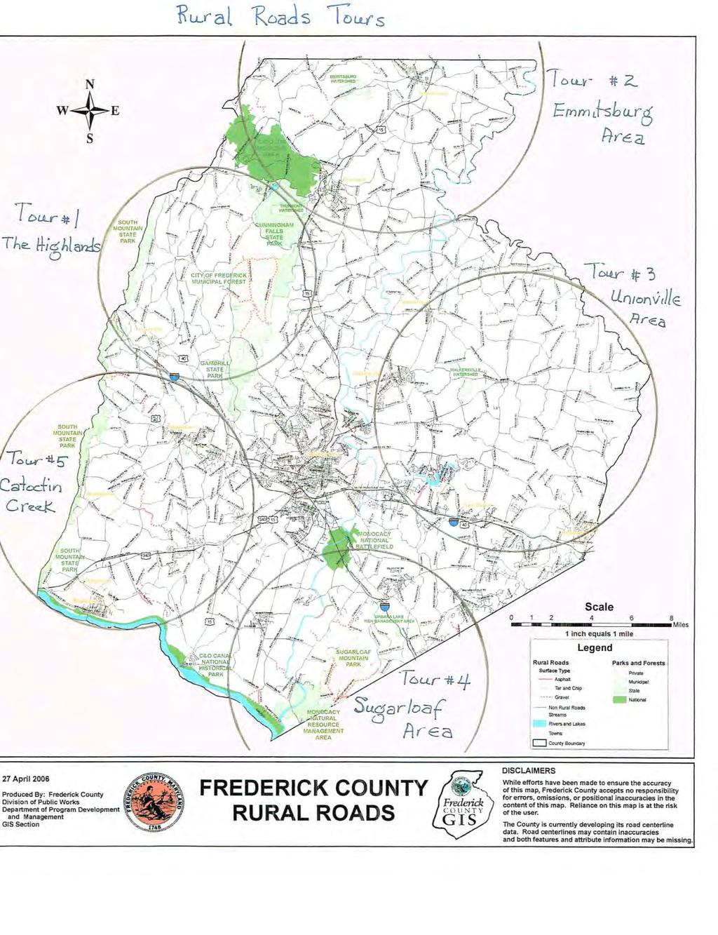
Frederick County, MD Rural Roads Tour # 3
|
|
|
- Berniece Roberts
- 5 years ago
- Views:
Transcription
 There are 5 separate tours of Frederick County s Rural Roads.")
1 Frederick County, MD Rural Roads Tour # 3 Unionville Loop Tour mileage: Approx. 63 miles Driving time: about 3 ½ hours (not including stops) There are 5 separate tours of Frederick County s Rural Roads. The selection of roads for these tours is being compiled to celebrate the 10 th Anniversary of the enacting of the county s Rural Roads Program. Each Rural Road has some gravel section. They contribute to the county s rural character both as glimpses into what life used to be like, and as champions of natural beauty. All 5 tours start and end at the Frederick County Visitors Center, 151 S. East Street in Frederick. Hopefully, taking one tour will motivate you to see them all and become a supporter of these beautiful roads. All of the county s Rural Roads contain sections that are one lane, narrow, curvy, and hilly. They are all beautiful gems. The roads in the Rural Roads Program that you will be driving on in this tour are capitalized and underlined. Some roads have been excluded for safety and brevity. Do not attempt this tour during inclement weather, at night, or in a low-hung vehicle. Please drive slowly and cautiously. Enjoy! Tour #3 in Eastern Frederick County takes you through some wonderful old historic areas from Johnsville where many of the early settlers of Frederick County resided, to Pearre Rd with its beautiful historic mansion, and to the railroad towns of Woodsboro and Walkersville. The famous Black Ankle Winery is also on the tour route. 1. From the Frederick Visitors Center turn Right (South) on East Street for.6 miles. Get in Left lane to merge onto I-70 East. 2. Turn Left (East) onto I-70 East for 14 miles to Exit 68, SR 27, to Mount Airy. 3. Turn Left onto SR 27 for 0.4 miles to traffic light at S. Main St.
, designed by Baltimore architect E. Francis Baldwin.) 5. Bear Left onto Buffalo Road for 0.9 miles to a fork with OLD BOHN RD.")
2 4. Turn Left onto S. Main Street for 1.6 miles to a fork with Buffalo Road. You are now in the village of Mount Airy, driving through their historic district. (At 1.3 miles on S. Main St on the right is the Baltimore & Ohio Railroad Station (1875), designed by Baltimore architect E. Francis Baldwin.) 5. Bear Left onto Buffalo Road for 0.9 miles to a fork with OLD BOHN RD. (If you are pressed for time, consider skipping instructions 6 through 11 to save about 10 minutes. If you do, take the right fork to stay on Buffalo Road and go north another 4.3 miles to BLACK ANKLE RD.) 6. Bear Left onto OLD BOHN RD for 1.2 miles to a T-intersection with MATTIE HAINES RD. At this point OLD BOHN RD becomes a gravel road. 7. Turn Right to stay on OLD BOHN RD for 0.7 miles to Woodville Road. 8. Turn Left onto Woodville Road for 0.6 miles to the other end of MATTIE HAINES RD. 9. Turn Left onto MATTIE HAINES RD for 0.6 miles to OLD BOHN RD. After 0.4 miles, MATTIE HAINES RD becomes a gravel road. 10. Turn Right onto OLD BOHN RD for 1.2 miles to Buffalo Road. 11. Make a sharp Left Turn onto Buffalo Road for 4.2 miles to BLACK ANKLE RD. You will pass through the hamlet of Harrisonville 2.1 miles after you turn onto Buffalo Road. 12. Turn Left onto BLACK ANKLE RD for 2.0 miles to a T-intersection. After one mile, BLACK ANKLE RD becomes a gravel road. 13. Turn Right to stay on BLACK ANKLE RD for 1.1 miles to Unionville Road. This section of BLACK ANKLE RD is all paved. 14. Turn Left onto Unionville Road for 0.3 miles to ALBAUGH RD. 15. Turn Right onto ALBAUGH RD for 2.2 miles to MD Route 31, New Windsor Road. After a half mile, ALBAUGH RD crosses MD Route 26,Liberty Road. One-tenth mile after crossing MD Route 26, turn right to stay on ALBAUGH RD. ALBAUGH RD becomes gravel at this point for 0.6 miles 2
3 16. Turn Left onto MD Route 31, New Windsor Road, for 0.3 miles to McKinstrys Mill Road. 17. Turn Right onto McKinstrys Mill Road for 3.1 miles to PEARRE RD. Onetenth of a mile short of PEARRE RD, McKinstrys Mill Road crosses Sam s Creek and into the 26-acre McKinstrys Mills Historic District. (On your right are the remains of the 3 ½ story McKinstry Mill, which dates back to The McKinstrys Mills Historic District is a national historic district comprising the entire hamlet of McKinstrys Mill, consisting of six properties developed by the McKinstry family. Besides the mill, there is the McKinstry homestead, built between 1825 and 1835; the residence of miller, Samuel McKinstry, dated 1849; a store building of 1850; and two other small houses and a variety of outbuildings.) 18. Turn Left onto PEARRE RD for 1.4 miles to Clemsonville Road. After driving on gravel for 0.7 miles, you will pass the Sam s Creek Methodist Protestant Churchyard, where the Albaughs and the McKinstrys are buried. At this point PEARRE RD becomes paved for 0.2 miles to the bridge over Clemson Branch. One-tenth of a mile further, you will pass the Pearre- Metcalf House on the right at Pearre Rd. (The Pearre-Metcalf House is on the National Register of Historic Places. It is a Greek Revival style farmhouse built about There is also a magnificent old barn and a small brick springhouse with corbelled brick cornice and tin roof.) 19. Turn Left onto Clemsonville Road for 0.2 miles to a stop sign at Fountain School Road. 20. Turn Right onto Fountain School Road for 1.0 mile to Molasses Road. 21. Turn Right onto Molasses Road for 0.2 miles to REPP RD. 22. Turn Right onto REPP RD for 1.5 miles to MD Route 75, Green Valley Road. (If you are pressed for time, consider skipping instructions 23 through 26 to save about 10 minutes. If you do, TURN LEFT onto MD Route 75, Green Valley Road for 2.9 miles through the picturesque hamlet of Johnsville to Renner Road.) 23. Turn Left onto MD Route 75, Green Valley Road, for 0.7 miles to DOTTERER RD. 24. Turn Left onto DOTTERER RD for 0.6 miles to Molasses Road. 25. Turn Right onto Molasses Road for 1.1 miles to a stop sign at MD Route 75,Green Valley Road, in the hamlet of Johnsville. (Kitterman-Buckley Farm at Molasses Road is on the National Register of Historic Places. This farm is the remnant of a farm established by German immigrant Christopher Kitterman in 1752, which remained in the 3
4 Root/Buckley family from 1790 to The main house was built about 1752 and is two stories in height. It is composed of two halves, built probably 40 to 50 years apart, and united under a low-sloping slate roof with three chimneys, with additions made in the 19th century and again in the 1950s and 1980s. Also on the property are a springhouse and cabin / smokehouse both dating to about 1752, a machine shed, horse barn built about 1930, a bank barn built about 1850, and a silo from 1934.) 26. Turn Left onto MD Route 75, Green Valley Road, for 0.4 miles to Renner Road. 27. Turn Right onto Renner Road for 0.7 miles to WHISKEY SPRINGS RD. 28. Go Straight onto WHISKEY SPRINGS RD for 1.5 miles to Coppermine Road. 29. Turn Right onto Coppermine Road for 2.5 miles to a traffic signal at MD Route Go Straight 0.1 mile to Main Street in Woodsboro. 4 Detour to Glade Valley Mill and Woodsboro Railroad Station: Skip direction 31 below. TURN LEFT onto Main Street for about 35 yards to Creagerstown Road. TURN SHARP RIGHT onto Creagerstown Road and go over the bridge 0.1 mile to the railroad tracks and turn around. RETRACE your route to Main Street. TURN RIGHT onto Main Street for 1.1 miles to MD Route 194. The Glade Valley Mill is a steam-powered flourmill built about A common feature of large 19 th Century flourmills is a mansard roof with dormers. The mill closed in Woodsboro Railroad Station was built by a subsidiary of the Pennsylvania Railroad in Passenger service ended in 1948 and the station was closed in Locally raised goldfish were shipped all over the country from this station in the early 20 th Century. The Woodsboro Historical Society owns the station. 31. TURN LEFT onto Main Street for 1.1 miles to MD Route 194. Walkersville Railroad Stations. The Walkersville Southern Railroad, a tourist railroad, owns the combination station and the rare freight house. At one time, a small combination station and freight house were common in every village and small town served by a railroad.

5 5 Detour to Walkersville Railroad Stations and Walkersville Southern Railroad. Skip direction 32 below. Turn Right onto MD Route 194 for 3.1 miles to East Frederick Street in Walkersville. Bear Right onto E. Frederick Street for 0.1 mile to South Glade Road. Turn Right onto S. Glade Road for 0.2 miles to a Stop Sign at Pennsylvania Avenue. Turn Left onto Pennsylvania Avenue and go 0.7 miles to the railroad tracks and turn around. RETRACE your route 0.1 mile to Fulton Street. Turn Right onto Fulton Street for 0.3 miles to West Frederick Street. Turn Right onto W. Frederick Street for 0.5 miles to MD Route 194. Turn Right onto MD Route 194 for 1.5 miles to MD Route Turn Right onto MD Route 194 for 5.9 miles to MD Route 26. (You will see the Ceresville Mill-Kelly Feed Mill facing MD Route 26 on your left. This water-powered mill was built about 1813 on the site of an older mill. Waterpower was supplemented by steam in 1850 and electricity in the1890 s. Its flour was sold under the Snow Drift and Pure Gold brand names. The mill was closed in 1988.) 33. Turn Right onto MD Route 26 for 1.4 miles to a left exit onto North Market Street. 34. Bear Left onto North Market Street for 1.0 mile to North East Street. At this point, a Coca Cola bottling factory will be on your right. 35. Turn Left onto North East Street for 1.7 miles to Frederick Visitor Center. Park your car and walk inside to see what else they have to offer.
6 6
7 7
Black Hill Regional Park, Little Seneca Lake
 Black Hill Regional Park, ittle Seneca ake ittle Seneca ake, in Black Hill Regional Park, is a reservoir created after a previous drought struck the Washington area. The park is under Maryland-National
*** Note: Mileages are based on resetting trip odometer to zero at each turn point AL-5 is Alabama Highway 5 CO-51 is County Road 51, etc.
 Directions to Ham(m) Family Reunion site of Lester Ham s Original Homestead Owned and hosted by Jeff & Renee Hamm Comments & corrections to Marv Hamm: MarvHamm@aol.com Ham(m) Family Reunion annually on
Rock Creek Park, MD - Lake Needwood
 ock Creek Park, MD - Lake Needwood Lake Needwood, is a reservoir located at the end of the north end of the ock Creek hiker-biker trail. At the other end, ock Creek empties into the Potomac iver near Thompson
Skiing and Snowshoes on Un-groomed Fernan Saddle Terrain
 Skiing and Snowshoes on Un-groomed Fernan Saddle Terrain Three ski or snowshoe routes are available from the Fernan Saddle Parking Lot which either do not cover routes ordinarily groomed for snow machine
Difficult Run Stream Valley Park
 Difficult Run Stream Valley Park The more intense mountain bikers have known about for Difficult Run for some time. Equestrians have known it longer. Eight miles of unpaved trail, the Rails to River Trail
BACKROADS BICYCLE/AUTOMOBILE TOUR OF MIDDLESEX, VERMONT
 BACKROADS BICYCLE/AUTOMOBILE TOUR OF MIDDLESEX, VERMONT (created and published by the Middlesex Historical Society) Welcome to a 25-mile self-guided historical tour of the backroads of Middlesex. You may
Map of Frederick County, Maryland 1858
 Map of Frederick County, Maryland 1858 To find your town, click on the name in the list below BUCKEYSTOWN CATOCTIN CREAGERSTOWN EMMITSBURG FREDERICK HAUVERS JACKSON JEFFERSON JOHNSVILLE LIBERTY MECHANICSTOWN
BRR Leg 1 (4.0 miles, Easy)
") BRR Leg 1 (4.0 miles, Easy) Min 3881 Max 4948 Ascent +36 Descent -1027 0.0 Start (Grayson Highlands State Park Visitor Center) 4.0 Grayson Highlands State Park Office & Gate, on L (EZ 1) Leg Notes: Minimal
BRR Leg 1 (4.0 miles, Easy) Min 3881 Max 4948 Ascent +36 Descent -1027 0.0 Start (Grayson Highlands State Park Visitor Center) 4.0 Grayson Highlands State Park Office & Gate, on L (EZ 1) Leg Notes: Minimal
Hudson Valley Vernacular Architecture Dutch Barn Preservation Society Field Trip to the Palatine Region of the Mohawk Valley May 18, 2013
 Hudson Valley Vernacular Architecture Dutch Barn Preservation Society Field Trip to the Palatine Region of the Mohawk Valley May 18, 2013 Trip Schedule Site Arrive Depart Old Palatine Church 10:30 am 11:15
Trailside Park, Herndon
 Trailside Park, Herndon Herndon is not the little rail stop it used to be. Like many of the smaller towns around Washington, D.C. Herndon has grown and changed. It even installed it s own little beltway,
Bikes talk to each other like dogs, they wag their wheels and tinkle their bells, the riders let their mounts mingle.
 Bikes talk to each other like dogs, they wag their wheels and tinkle their bells, the riders let their mounts mingle. Daniel Behrman, The Man Who Loved Bicycles W hitmore Lake Loop route: Dexter, the corner
Leg 1 (4.0 miles, Easy)
") Leg 1 (4.0 miles, Easy) Leg Description: Steady, but controlled downhill (paved). Leg Notes: Great views of the Grayson Highlands balds and mountains. Watch for wild ponies. 0.0 Grayson Highlands State
Leg 1 (4.0 miles, Easy) Leg Description: Steady, but controlled downhill (paved). Leg Notes: Great views of the Grayson Highlands balds and mountains. Watch for wild ponies. 0.0 Grayson Highlands State
Vienna. Getting There
 Vienna Like its famous and older German namesake, but on a smaller scale, Vienna, Virginia has a charm to it. Becoming increasingly more cosmopolitan, foreign restaurants, bagle and coffee shops line Maple
High Winder House & Holiday Cottages Tirril, Penrith, Cumbria, CA10 2LS Lake District National Park
 High Winder House & Holiday Cottages Tirril, Penrith, Cumbria, CA10 2LS Lake District National Park High Winder House, Tirril Page 4 of 16 High Winder House & Holiday Cottages An attractive 17 th Century
DIRECTIONS. to Howard County Public Schools and Facilities. Elementary Schools
 DIRECTIONS Elementary Schools Atholton Elementary 410-313-6853 6700 Seneca Drive Columbia, 21046 Take Clarksville Pike east to Rt. 29 south. Take exit for Seneca, Shaker Drive. At stop sign turn left.
Cleveland Photographic Society Amish Country Field Trip Saturday, August 15, 2015
 Cleveland Photographic Society Amish Country Field Trip Saturday, August 15, 2015 Trip Coordinator: Rob Erick 440-570-3352 Feel free to call or text along the way with any questions This trip is planned
CHRONOLOGY & DEVELOPMENT BOUDINOT-SOUTHARD PROPERTY BASKING RIDGE, NJ OF THE
 CHRONOLOGY & DEVELOPMENT OF THE BOUDINOT-SOUTHARD PROPERTY BASKING RIDGE, NJ Elias Boudinot 1740 Elias Boudinot born May 2 in Philadelphia, where his family was a neighbor of Benjamin Franklin. 1760 Boudinot
DIRECTIONS TO THE FIELDS
 DIRECTIONS TO THE FIELDS Northwest Connecticut Babe Ruth League AVON AVON HIGH SCHOOL -Traveling east on Route 44, take a right onto Route 167. Continue on Route 167 past the Avon Middle School. The field
Google Map:
 2018 PRRT&HS ANNUAL MEETING LAYOUT TOURS # OWNER SCALE FRI SUN DIST. 1 ALTOONA ASSOCIATION OF MODEL RAILROADERS O, HO, N 730PM-11PM 11AM-430PM 5 Mi. N 2 ALTO MODEL TRAIN MUSEUM ASSOCIATION O, S, HO SAT
Guide for 2018 Jackson Brigade Reunion Tour Written by Nancy Jackson, Last update July 24, 2018
 Guide for 2018 Jackson Brigade Reunion Tour Written by Nancy Jackson, Last update July 24, 2018 We will start from the "Super 8 by Wyndham Weston" motel parking lot Saturday August 4, 2018. Be there by
Tom's Run 2018 Course Map. Fairfield Inn and Suites 21 N Wineow Street Cumberland, MD Phone:
 Tom's Run 2018 Course Map Fairfield Inn and Suites 21 N Wineow Street Cumberland, MD 21502 Phone: 1-301-722-0340 Useful Information National Park Service C & O Canal Web site: http://www.nps.gov/choh/index.htm
History of Burlingame, Kansas. By John Hill Louisiana purchase by the United States from France (includes present-day Burlingame)
") History of Burlingame, Kansas By John Hill 1803 Louisiana purchase by the United States from France (includes present-day Burlingame) 1806 Zebulon Pike s exploration of the southwest portion of the Louisiana
History of Burlingame, Kansas By John Hill 1803 Louisiana purchase by the United States from France (includes present-day Burlingame) 1806 Zebulon Pike s exploration of the southwest portion of the Louisiana
APPENDIX K: BUILT HERITAGE AND CULTURAL HERITAGE LANDSCAPES
 APPENDIX K: BUILT HERITAGE AND CULTURAL HERITAGE LANDSCAPES TABLE 1: Built Resources (BHR) and Cultural Heritage Landscapes (CHL) Within and Adjacent to the West Whitby Secondary Plan Area Site # 1. CHL
MINNESOTA ARCHITECTURE - HISTORY INVENTORY FORM Property Location
 MINNESOTA ARCHITECTURE - HISTORY INVENTORY FORM ------ - Property Location -- ---- Property Name: Washington Park Address: 215 N 4th Street County: Blue Earth City/Twp: Mankato PIN: R01.09.07.461.001 Legal
The Buildings of Ailsworth
 Chapter 10 The Buildings of Ailsworth Introduction Today, old and new houses, large and small, stand side by side, the result of the natural growth of the village of Ailsworth. It is now difficult to imagine
UMASS CROSS-COUNTRY Trails
 UMASS CROSS-COUNTRY Trails 1) EGG (43 min) (A) From Cage proceed to North Pleasant street (by campus pond). Make left and head toward LGRT and pass School of Education. Pass Puffton Apt complex (on left)
Training Site Directions
 Training Site Directions Click on a facility to go to the directions BRIDGEPORT OFFICE. CENTRAL OFFICE 55 Farmington Ave 25 Sigourney Street (Former Central Office) Page 2 Page 2 DANBURY OFFICE HARTFORD
The Croatan MST Segment 16B
 1 Mountains-to-Sea Trail Last Updated 1/1/2017 A sandy road through longleaf pine savanna in the Croatan National Forest Photo by PJ Wetzel, www.pjwetzel.com The Croatan MST Segment 16B STELLA TO THE NEUSIOK
The Original Farm, Dairy & Sausage plant buildings
 The Original Farm, Dairy & Sausage plant buildings Featured below are images of the original Deerfoot farm buildings along Stony Brook. Beginning in 1894, the original farm buildings along with 20 acres
TRAFFIC ALERT FOR FEBRUARY 11-15, 2019 Highway Work Zones in the Staunton District
 RELEASE: IMMEDIATE February 8, 2019 CONTACT: Sandy Myers 540-332-9201 (office) STA19 027 540-292-2500 (cell) Sandy.Myers@VDOT.virginia.gov Ken Slack 540-332-9264 (office) 540-414-5670 (cell) Ken.Slack@VDOT.virginia.gov
Delaware Avenue Between North and Tupper Streets Chuck La Chiusa
 Delaware Avenue Between North and Tupper Streets 2013 Chuck La Chiusa BuffaloAH.com Wilcox Mansison / Theodore Roosevelt Inaugural Site 641 Delaware Avenue Greek Revival/Colonial Revival Palladian window
Cataloochee. Fishing Species Rainbow Trout and Brook Trout. Recreation
 Cataloochee River Information The Cataloochee River is located in the historic Cataloochee Valley--a relatively remote part of Smoky Mountain National Park. The campground is a secluded setting and offers
Springettsbury Township. Road Improvement Projects
 Springettsbury Township Road Improvement Projects 2009 2016 2016 Township Road Improvement Projects Springettsbury Township is divided into the following 4 Sectors: Northwest Sector Sherman Street Route
AUCTION BIDDING You may bid online during the auctions at www. LIVE ONLINE PORTFOLIO OVERVIEW
 PORTFOLIO OVERVIEW STATE COUNTY/ PARISH ACRES CROPLAND (FSA) AUCTION DATE Illinois Mercer 4,869± 4,657± Illinois Fulton 3,769± 3,596± December 12 Texas Hartley 11,240± Texas Moore 920± 11,646± December
Directions to Frequently Visited C & O Canal Locations
 Directions to Frequently Visited C & O Canal Locations Seneca Creek Montgomery County, Maryland Pass town of Potomac and Falls Road and continue west to Seneca Rd. Turn left on Seneca Rd. and continue
Foxhill Park, Bowie, Maryland
 Foxhill Park, Bowie, Maryland The approximately 50,000 residents of the city of Bowie, Maryland are proud of the trails that link the city. Many trails exist and many are planned. Bowie is a changing city.
History/Descriptive Notes: 3.5 acres with orchard that was actively used until current owner purchased in 1982.
 Address: 4395 McCandlish Road Tax Parcel Number: 12-22-200-031 Year Built: 1926 (per owner) Architectural Style: Craftsman Other Buildings/Features: garage (date unknown) 61 History/Descriptive Notes:
Railroad Buff Day Trip
 Railroad Buff Day Trip The region around Ebensburg has a rich history in railroading. This ride includes the Cresson Rail Yard, the Gallitzin Tunnels, Horseshoe Curve, Railroaders Museum in Altoona, a
TRAFFIC ALERT FOR DECEMBER 25, 2017 to JANUARY 5, 2018 Highway Work Zones in the Staunton District
 RELEASE: IMMEDIATE December 21, 2017 CONTACT: Sandy Myers 540-332-9201 (office) STA17-204 540-292-2500 (cell) Sandy.Myers@VDOT.virginia.gov Ken Slack 540-332-9264 (office) 540-414-5670 (cell) Ken.Slack@VDOT.virginia.gov
Baltimore County Nature Quest NEW TRAILS 2014
 Baltimore County Nature Quest NEW TRAILS 2014 Nature Quest Park Locations Robert E. Lee Park Cromwell Valley Park Agricultural Ctr. & Farm Park Honeygo Regional Park Marshy Point Park and Nature Center
808 Cherry Avenue
 808 Cherry Avenue 104-0213-0059 Primary Resource Information: Single Dwelling, Stories 2.00, Style: Other, ca 1900 July 2006: This 2-story, 3-bay frame I-house features a central-front gable, a brick pier
The Early Settlers Revised: September 7, 2013
 The Early Settlers Revised: September 7, 2013 The earliest settlers were farmers. Among the largest farmers in 1860 were: Adams, of which there were several, Phillips, Lynch, Avery, Gere, Garrett and Malloy.
43 STONE MOUNTAIN LOOP
 204 60 hikes within 60 miles: atlanta 43 STONE MOUNTAIN LOO i KEY AT-A-GLANCE INFORMATION LENGTH: 5.5 miles CONFIGURATION: Loop DIFFICULTY: Easy SCENERY: Views of Stone Mountain and Confederate Memorial;
TRAFFIC ALERT FOR JANUARY 15-19, 2018 Highway Work Zones in the Staunton District
 RELEASE: IMMEDIATE January 11, 2018 CONTACT: Sandy Myers 540-332-9201 (office) STA18-007 540-292-2500 (cell) Sandy.Myers@VDOT.virginia.gov Ken Slack 540-332-9264 (office) 540-414-5670 (cell) Ken.Slack@VDOT.virginia.gov
Columbia, Maryland - Village of Owen Brown
 Columbia, Maryland - Village of Owen Brown From the Village of Owen Brown, good trails stretch to other neighboring Columbia villages. Mostly following stream valleys, the trails go to and from schools
Hiking Las Vegas.com
 Hike: Juniper Peak up and back Trailhead: Oak Creek Canyon marked Distance: 5.5 miles round trip Elevation gain: 2,200 feet Elevation peak: 6,109 feet Time: 4 to 5 hours - Up and back Difficulty: 3 Danger
SUPERB FARM OF AROUND 50 ACRES WITH GRADE II LISTED FARMHOUSE ABBEY FARM DUCKPOOL LANE, STIXWOULD, WOODHALL SPA, LINCOLNSHIRE LN10 5HR
 SUPERB FARM OF AROUND 50 ACRES WITH GRADE II LISTED FARMHOUSE ABBEY FARM DUCKPOOL LANE, STIXWOULD, WOODHALL SPA, LINCOLNSHIRE LN10 5HR SUPERB FARM OF AROUND 50 ACRES WITH GRADE II LISTED FARMHOUSE AND
T H E L E T T E R. only made. but also gave. of character.
 1 T h e L e t t e r S outhern Indiana in August is hot and so dry that the ground is usually cracked by that time of the year. But when you grow up living and working on a farm, you get used to the hot
Walking Tour. America s first textile village. Intro Walking Tour Directions. Water Powered! BlackstoneHeritageCorridor.org
 Walking Tour slatersville North Smithfield, RI America s first textile village. Intro Walking Tour Directions Slatersville Congregational Church and Mill. Photo courtesy of the Blackstone Valley Tourism
Collyers Farm. Lickfold West Sussex
 Collyers Farm Lickfold West Sussex A beautiful period farmhouse, Listed Grade II with stables and outbuildings, mature landscaped gardens and paddocks, set in about 22 acres Features Hall Drawing room
ANITA LOUISE EHRMAN - Greenway Avenue/Armonk/10504
 Directions to Area Swim Clubs: ANITA LOUISE EHRMAN - Greenway Avenue/Armonk/10504 From north, take 684 south to exit 3, left at end of exit ramp onto route 22 north, left at blinker light at Yellow Barn
The George Rieley home place, built 1852, from bricks molded and baked on the premises.
 The George Rieley home place, built 1852, from bricks molded and baked on the premises. 1. SUBJECT: Old Riley [sic] Place. 2. LOCATION: 1/16 mile east of Blue Ridge Va. on Route /460. House on north side
Cobblestone Buildings in Seneca County
 Cobblestone Buildings in Seneca County There are at least twelve cobblestone structures still in use in Seneca County today. Using an Ice Age residue of glacially-rounded native stones, pioneer craftsmen
Corridor Management Plan for Virginia Coal Heritage Trail WMTH Corporation, 2011, trailsrus.com
 CHAPTER IV: HIGHLIGHTS Along the The St. Paul loop travels over 80 miles through the counties of Russell, Scott, Lee and Wise before ending back at St. Paul. As noted earlier, St. Paul holds the distinction
The Holzworth Family. Papa, Marie, Julia, John, Sophie and Mama. Johnnie Holzwarth and Caroline (Pratt) Virginia, Mary Francis and John III
 Virginia, Mary Francis and John III") The Holzworth Family John Gotlieb Holzworth Sophie Lefromm Holzworth Papa, Marie, Julia, John, Sophie and Mama Johnnie Holzwarth and Caroline (Pratt) Virginia, Mary Francis and John III HOLZWORTH TROUT
The Holzworth Family John Gotlieb Holzworth Sophie Lefromm Holzworth Papa, Marie, Julia, John, Sophie and Mama Johnnie Holzwarth and Caroline (Pratt) Virginia, Mary Francis and John III HOLZWORTH TROUT
Greenbush Town Hall / Fire Station
 Page 1 of 18 Course Description Greenbush Town Hall / Fire Station Both races start in front of the Greenbush Town Hall / Fire Station, just south of Highway 23 on Sugarbush Road. Parking will be in the
The purpose of this document is for organizers who have not designed a GTA Rally to be able to see what one looks like on paper.
 Frederick County Historic Bridge Rally Sample Document 1) General s 2) s 3) Answer Sheet The purpose of this document is for organizers who have not designed a Rally to be able to see what one looks like
Fort Ticonderoga Carillon Battlefield Walking Trail Guide
 Fort Ticonderoga Carillon Battlefield Walking Trail Guide Copyright Fort Ticonderoga. Photo Credit Carl Heilman II Length: Approximately 1¾ mile Welcome to Fort Ticonderoga s Walking Trail Blue markers
Maplehurst, 42 Abbotsford Road, Galashiels. Macpherson Property, 3 St. Dunstans Lane, Melrose, Scottish Borders TD6 9RS Tel:
 Maplehurst, 42 Abbotsford Road, Galashiels Macpherson Property, 3 St. Dunstans Lane, Melrose, Scottish Borders TD6 9RS Tel: 01896 820 226 Maplehurst is quite simply the most immaculately presented and
This path goes past an old tree nursery and sawmill. After 800m it crosses over a lane. Follow the bridleway fingerpost into the woods.
 FRENSHAM PONDS 11K CIRCULAR TRAIL 2½ HRS GU10 2DA This magnificent heathland trail starts in woodland and then brings you out onto the open heather of Frensham Common, with no roadwork! The route runs
Kitimat. Pacific Inland Coast. Hiking Guide Kitimat, British Columbia, Canada
 Kitimat Pacific Inland Coast Hiking Guide Kitimat, British Columbia, Canada 2010-2011 Sites and Trails Emergency Call 911 Police - Fire - Medical 2 Welcome to Kitimat This information was produced to assist
English charm in Northern Tasmania
 ilfracombe park English charm in Northern Tasmania Magnificent lifestyle block Tudor-style architectural home Authentic slate-tiled roof Established low-maintenance gardens Inground swimming pool & entertainment
2 7 5 L O O P 2 5 : : E
 275 loop 25 :: Eden Park 125 Eden Park 25 In Brief Eden Park offers an array of activities, including a playhouse, amphitheater, conservatory, art museum, outdoor sculptures, and gardens. Plan to spend
OLd Fairchild. - Headquarters - $1,600,000 $2,250,000. Old Fairchild. Offered at Alapay Ranch Way Harmony, California 93435
 OLd Fairchild - Headquarters Harmony, California Offered at $2,250,000 $1,600,000 Phone: (805) 238-7110 Fax: (805) 238-1324 BRE# 00656930 Description Water is supplied via seasonal creeks and one well
301 7½ Street SW
 301 7½ Street SW 104-0213-0072 Primary Resource Information: Single Dwelling, Stories 2.00, Style: Other, ca 1890 July 2006: This late-19th-century, 3-bay, 2-story, hip-roofed frame I-house features projecting
State Level Historic Documentation Report. John Blue Bridge Hampshire County
 State Level Historic Documentation Report State Project No. S314-28-22.27 Federal Project No. BR-0028(058)D John Blue Bridge Hampshire County Prepared by: Randy Epperly, Historian Department of Transportation
Hiking Las Vegas.com
 Hike: Mt. Wilson via First Creek Canyon route Trailhead: First Creek marked Distance: 10 miles up and back Elevation gain: 3,400 feet Elevation of Peak: 7,070 feet Time: 7 to 9 hours (up and back) Difficulty:
Address: Fenton Road Tax Parcel Number: Year Built: 1929
 Site Name: Camp Copneconic 39 Address: 10407 Fenton Road Tax Parcel Number: 12-31-300-001 Year Built: 1929 (date source: Tax records) Architectural Style: American Lodge/Timber Framed Other Buildings/Features:
Annual Book Publishing Conference 2015
 Annual Book Publishing Conference 2015 Fort Edmonton Park Edmonton, Alberta Conference Venue Information Package Table of Contents 3 Getting to the Park 10 Parking 11 Event Venues 15 Hotel Booking 16 Questions
Cumberland County Hiking Marathon Trail Descriptions
 Cumberland County Hiking Marathon Trail Descriptions 8/28/2017 Welcome to the 2017 Cumberland County Hiking Marathon. As you hike these trails you will enjoy a wide variety of terrain and geographical
National Register of Historic Places Inventory Nomination Form
 NPS Form 10-900-a Exp. 10-31-84 Continuation sheet 4 5 item number 7 Page 45 NAME: Knight Estate LOCATION: 486 East Avenue,,--v..u^-^ OWNER: State of Rhode Island Department of Education Board of Regents
Western Maryland Railway
 Western Maryland Railway WESTERN MARYLAND RAILWAY...................................................... Art. of consol. in MD and PA, February 15, 1917 626.022 mi. First main track 67.670 mi. Second main
STATE OF IOWA. Historical and Architectural Survey for 2008 Flood Projects in Vinton, Benton County
 STATE OF IOWA CHESTER J. CULVER GOVERNOR PATTY JUDGE LT. GOVERNOR DEPARTMENT OF PUBLIC DEFENSE IOWA HOMELAND SECURITY AND EMERGENCY MANAGEMENT DIVISION DAVID L. MILLER, ADMINISTRATOR Historical and Architectural
Langford Road, East Candia. East Candia. A Walking Tour. Published by Candia Heritage Commission September 2013
 Langford Road, East Candia East Candia A Walking Tour Published by Candia Heritage Commission September 2013 Methodist Church In 1894, the Methodist Society built a church at what is today 163 Langford
Hunter Water S170 Register
 SHI No.: 3630112 Location Name: 800 Salisbury Rd, Munni NSW 2420 Other ID nos HW ID: 130. Description: The house is set on a buff over looking the creek The house is built in the colonial style, single
House, Buildings & 4.56 Acres m/l Linn County, IA Old Quaas Road, Alburnett, Iowa 52202
 HOUSE FOR SALE House, Buildings & 4.56 Acres m/l Linn County, IA 2713 Old Quaas Road, Alburnett, Iowa 52202 Property Information Location From Alburnett: ½ South on Alburnett Road and ½ west on Old Quaas
In 1850, Congress passed a law donating two and one half million acres to the State of Illinois for the use of the Illinois Central Rail Road.
 Merna The town of Merna was founded by primarily Irish and German farmers. Their faith and families were an integral part of who they were. There was and still is today a strong sense of community. Most
Heritage Outlook News from the Historic Preservation Trust of Lancaster County
 Heritage Outlook News from the Historic Preservation Trust of Lancaster County February 2014 IN THIS ISSUE 2014 Watch List Officers Installed Historic Site Marker Plaques Annual Fund and 2014 Membership
DIRECTIONS TO HMG OFFICES
 DIRECTIONS TO HMG OFFICES AVON, ROUTE 10 100 Simsbury Road, Avon, CT 06111 (860)-284-5111 FROM I-84 WEST BOUND Take exit 43 (Park Road/West Hartford Center). Turn left at light at end of ramp. At second
Piscataway (84-023) Mary Quarterly, 3rd Ser., Vol. 36, No. 4. (Oct., 1979), pp Preservation Section, 1.
 Mary Quarterly, 3rd Ser., Vol. 36, No. 4. (Oct., 1979), pp Preservation Section, 1.") Piscataway (84-023) Piscataway, located in southwestern Prince George s County, is one of the oldest villages in the county. Piscataway takes its name from a Native American tribe of the same name that
Piscataway (84-023) Piscataway, located in southwestern Prince George s County, is one of the oldest villages in the county. Piscataway takes its name from a Native American tribe of the same name that
A CONCEPT FOR F.H. BARBER PROVINCIAL PARK.
 A CONCEPT FOR F.H. BARBER PROVINCIAL PARK. 2-7-4-101-27 APPROVAL This Concept for F.H. Barber Provincial Park has been reviewed and is approved. Lower Mainland Region Parks and Outdoor Recreation Division
Norfolk and Western Railway
 Norfolk and Western Railway NORFOLK AND WESTERN RAILWAY................................................... Gen. act of VA, January 15, 1896 Trackage, June 30, 1916: 2051.280 mi. First Main track 546.328
Directions to Gathering/other Events:
 Directions to Gathering/other Events: Scroll down the list below (churches are in alphabetical order)!! Andrews Chapel UMC: From Conway: From Conway: Take 501 to Highway 31 North. Take the Highway 9 exit
Intensive Level Historic Resources Survey 5.0 ANNOTATED LIST OF PROPERTIES
 Intensive Level Historic Resources Survey 5.0 ANNOTATED LIST OF PROPERTIES CBCA PN 05-012A May 2009 Photo Location Description 10760 Bodine Road Date: 1811 Historic addition of side block to the rear;
Bankhead Lake TWO PARCELS AND 1 LOT FOR SALE
 OVERVIEW NORTH PARCEL ACRES: 46 WATERFRONT: 1,227 Front Feet PRICE: $350,000 PER ACRE: $7574 PER FRONT FT. $285 SOUTH PARCEL ACRES: 22 WATERFRONT: 1,381 Front Feet PRICE: $295,000 PER ACRE: $13,170 PER
VDOT HOT SPOTS IN THE FREDERICKSBURG DISTRICT Aug , 2016
 RELEASE: IMMEDIATE Aug. 12, 2016 CONTACT: Kelly Hannon 540-374-3344 (office) 540-656-0321 (cell) Kelly.Hannon@VDOT.Virginia.Gov Stafford County Tina Bundy 540-899-4560 (office) 540-907-8325 (cell) Tina.Bundy@VDOT.Virginia.Gov
Lane Residence. Silverthorne, Colorado. Offered for $3,999,999. Contact Bill George. (970)
") Lane Residence Silverthorne, Colorado Offered for $3,999,999 Contact Bill George (970) 485 1052 bill@ranchland.com Ownership of this 6,450 square foot custom log home at Shadow Creek Ranch gets you access
Lane Residence Silverthorne, Colorado Offered for $3,999,999 Contact Bill George (970) 485 1052 bill@ranchland.com Ownership of this 6,450 square foot custom log home at Shadow Creek Ranch gets you access
A Publication of Friends of Sleeping Bear Dunes
 A Publication of Friends of Sleeping Bear Dunes 2014, Friends of Sleeping Bear Dunes, P.O. Box 545, Empire, MI 49630 www.friendsofsleepingbear.org info@friendsofsleepingbear.org Learn more about the Friends
The View at Bankhead Lake 12 miles off new Interstate Corridor X
 The View at Bankhead Lake 12 miles off new Interstate Corridor X offers the opportunity to the first to view 6 beautiful waterfront lots on Bankhead Lake to be released Saturday August 25th. Appointment
AFTERNOON RUN IS REVERSE OF MORNING RUN
 BUS #202 EMMETT ELEMENTARY SCHOOL RIGHT ON JONESBORO ROAD, RIGHT ON DEERFIELD RETRACE, RIGHT ON JONESBORO ROAD, LEFT ON HIGHWAY 421, CROSS ON TO JONESBORO ROAD, LEFT AT LIGHT ONTO BRISTOL CAVERNS HIGHWAY,
TRAFFIC ALERT FOR SEPTEMBER 10-14, 2018 Highway Work Zones in the Staunton District
 RELEASE: IMMEDIATE September 7, 2018 CONTACT: Sandy Myers 540-332-9201 (office) STA18 148 540-292-2500 (cell) Sandy.Myers@VDOT.virginia.gov Ken Slack 540-332-9264 (office) 540-414-5670 (cell) Ken.Slack@VDOT.virginia.gov
BROUGHTON GROVE FARMHOUSE, FIELD BROUGHTON. An investigation using documentary evidence.
 BROUGHTON GROVE FARMHOUSE, FIELD BROUGHTON. An investigation using documentary evidence. Location of house. Grove Farmhouse (BGF) is in the hamlet of Field which is 2 miles north of. Access is via a track
Beaver Creek State Park
 GENERAL INFORMATION Name of Park/Forest/Facility: Beaver Creek State Park County: Columbiana (St. Clair Township) Address: 12816 Sprucevale Road (ie County Rd 428) (street #, city) East Liverpool, Ohio
24 EARL STREET WALKING TOUR
 24 EARL STREET WALKING TOUR This walk covers four city blocks of Earl Street, one of the oldest streets in Kingston. APPROXIMATELY 45 MINUTES Please be respectful of private property. 24 EARL STREET WALKING
Oak Creek Assembly of God FOR YOUR SAFETY
 Oak Creek Assembly of God New York City-"The Big Apple" 6 Days/5 Nights Departing from: Start Date: Thursday, May 22, 2014 Oak Creek Assembly of God Church (South Side by Door #10) 7311 South 13th Street
Delta s RURAL HERITAGE
 Delta s RURAL HERITAGE A DRIVING TOUR FEATURING A SELECTION OF DELTA S HISTORICALLY SIGNIFICANT RURAL BUILDINGS AND SITES Delta s Heritage Advisory Commission invites you to embark on a tour of Delta s
OLd Fairchild. - Headquarters - Harmony, California. Offered at $2,250,000.
 OLd Fairchild Harmony, California Offered at $2,250,000 www.clarkcompany.com 1031 Pine Street Paso Robles, California 93446 Phone: (805) 238-7110 Fax: (805) 238-1324 info@clarkcompany.com Description Embraced
Cr./Left Fork of Boulder Creek/Horse Creek Made it 2.2 miles from Hwy on Left fork of Boulder Creek. Heavy washout;
 Road Inspector Inspection Inspection Date North Fork Mark M. 6/7 Open Boulder Cr. Helitack 6/16 no signs on either section of Boulder Cr. 2) we were able to make it to the creek crossing on Boulder Cr.
Packthorne Farm WHITMINSTER, GLOUCESTER
 Packthorne Farm WHITMINSTER, GLOUCESTER Packthorne Farm WHITMINSTER, GLOUCESTER Gloucester 8.5 miles Cheltenham 18 miles Bristol 30 miles M5 Junction 13 2 miles (distances are approximate) Impressive
A Walking Tour Through Glen Tay Historic Hamlet on Glen Tay Road in Tay Valley Township (formerly, Bathurst Township)
") A Walking Tour Through Glen Tay Historic Hamlet on Glen Tay Road in Tay Valley Township (formerly, Bathurst Township) Introduction Welcome to the historic hamlet of Glen Tay. This walking tour, and the
A Walking Tour Through Glen Tay Historic Hamlet on Glen Tay Road in Tay Valley Township (formerly, Bathurst Township) Introduction Welcome to the historic hamlet of Glen Tay. This walking tour, and the