Columbia, Maryland - Village of Owen Brown
|
|
|
- Lydia Roberta Benson
- 6 years ago
- Views:
Transcription
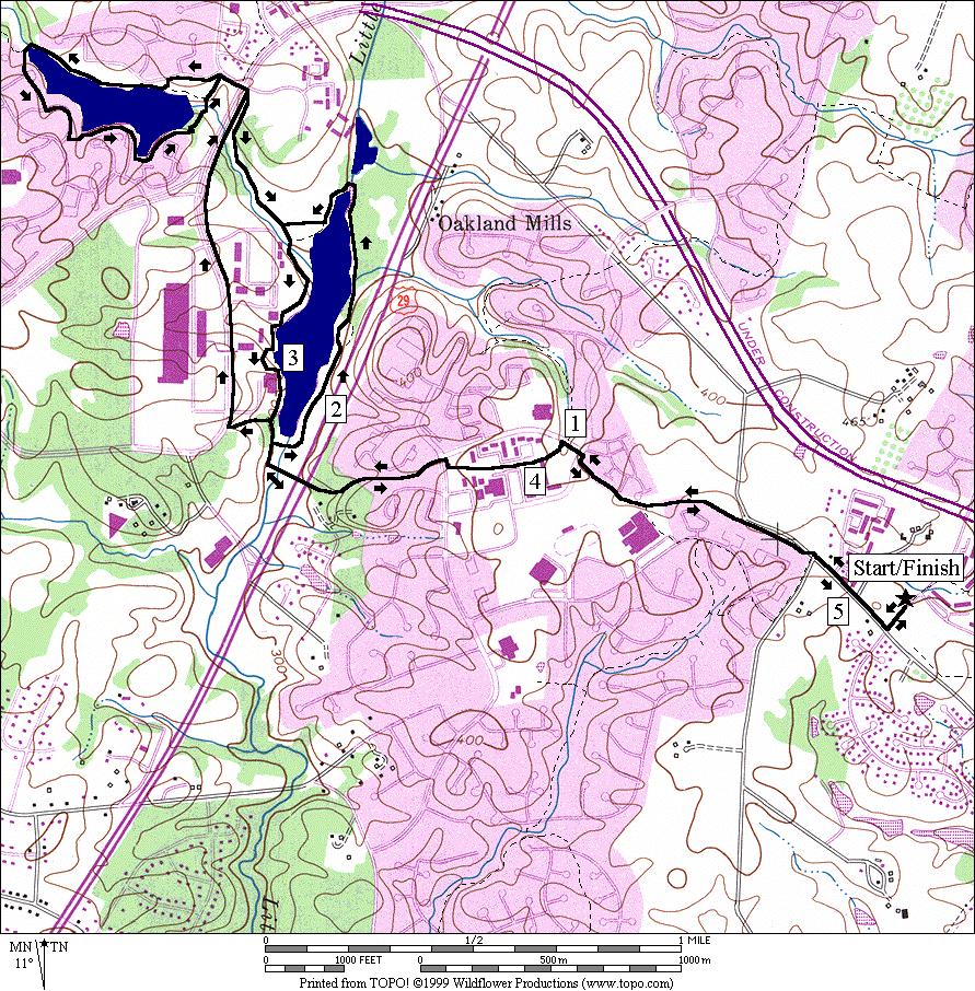
1 Columbia, Maryland - Village of Owen Brown From the Village of Owen Brown, good trails stretch to other neighboring Columbia villages. Mostly following stream valleys, the trails go to and from schools as well. Jeffers Hill Elementary School, where routes in this section start, is just one of these. Owen Brown also is situated near many of Columbia s business parks. The Steven s Forest trails lead down from the high school to ake Elkhorn which is near the business parks also. Going the other direction, the Talbot Springs trail system passes through the Village of Oakland Mills to the Columbia town center. Additional trails loop through the Village of ong each to the north. Following some of the trails in the area can be daunting even for those living in Columbia. Many spurs break-off from the main trails without signs. It s not always evident which one is the main trail. Where there are signs, they are often painted onto the pavement and get worn off. When you can read them, they indicate directions to roads at the ends of the spurs, not how to follow the main trail. However, occasional detailed maps at turns do make passing through easier. The trickiest parts of the routes described here are laid-out to go downhill. Thus when a turn comes up, you can usually be correct by following the one that goes down hill along the stream valley. If you plan to run the trails and are unfamiliar with them, consider going with a friend who knows them, or consider bicycling the route first so that you can get familiar with it. If you make a mistake on bicycle, you can correct it more easily. I found that going over a route once or twice was all it took to be comfortable following it without having to stop for directions. Getting There From the Capital Beltway (I-95), take I-95 north toward Baltimore. After approximately 14 miles from the beltway, take ittle Patuxent Pkwy. te. 175 west. After approximately 3 miles, turn left onto Tamar Dr. Turn left after one-quarter mile and park at Jeffers Hill Elementary School. Area outes ake Kittamaqundi (5.15 or 7.4 miles, IV or VI) Columbia s town center is located on the west edge of ake Kittamaqundi. Just further west of the town center is The Mall in Columbia. Getting there from Jeffers Hill Elementary School, pass through open areas and the border of Oakland Mills High School. Dropping into the Talbot Springs trail system, arrive at the lake after crossing the foot bridge over Columbia Pike, te. 29. The paved trail at the lake does not fully circle the lake. To complete the circle, some dirt paths must be used which can be considerably muddy after rains. The dirt trail itself becomes grassy on the north side and is hard to discern briefly. At one point on the grassy section, it breaks away perpendicular to the shore of the lake, eventually becoming wood chip and gravel just before hitting a paved section just over 400ft. away from the lake. Another awkward part is at the town center. Bearing left at a trail split to stay near the shore again, you must go over wooden docks, and some sloping wide stairs. Bicycles are not allowed on this part. Watch for restaurants as you pass to come back to after you finish. An optional extension goes around the town center along the ittle Patuxent Pkwy, on to Wilde ake. See the description of the route around Wilde ake
2 under Columbia, Maryland - Centennial ake. ake Elkhorn (7.6 or 5.95 or 7.95 miles, VI, V, or VII) Poised off the Broken and Parkway, ake Elkhorn achieves the picture-book setting that Columbia s developers had wanted to create. It s got the nicest lake trail in Columbia. People hang-out suntanning on the dam as water rushes over it. The trail is on a wooden dock in one cove. Great Blue Heron s in the wetland on the east, seem un-bothered by the passers-by. Get there first by passing by Oakland Mills High School and picking-up the trail head at Kilamanjaro d. The Steven s Forest trail system gets you most of the rest of the way there. There are many spurs off it but until you cross Farewell d., you can follow the route without having to remember turns, just by going downhill. A T-intersection after Farewell d., under power lines will remind you to turn uphill for a brief stretch to the Owen Brown Community Center. Another unnamed trail afterward gradually drops you down to the lake. The loop around the lake is 1.85 miles, just the same distance as that around ake Kittamaqundi. The middle distance route described here does all but one-tenth of a mile of this before leaving, by following along the main creek feeding the lake. The short option only stays at the lake shores for the one-tenth mile. A portion of the mid and short routes is on a hilly dirt and gravel road, along power lines. The long route goes around the lake but adds-on a trail toward Brush un. The long route requires climbing a bigger hill but is all paved. It also passes by the Christ Episcopal Church, a place of worship since All three options are united again at Oakland Mills d. There a very nice quiet trail crosses under the road and follows the main creek feeding ake Elkhorn back to Jeffers Elementary. The way back is shady with few turns or road crossings to contend with. It s one of the nicest trails in Columbia. Village of ong each (5.9 miles, V) This route crosses north of the ittle Patuxent Pkwy. (te. 175) and rambles through the Village of ong each. Coming back, it crosses back under the parkway, to return through the Village of Oakland Mills. Most of the route is on quiet paved trails however a little over 1.5 miles are through suburban residential streets. The trails use tunnels to get past most of the major roads. The route is equally shady and open with no severe hills. Though there are many turns indicated, the route is on main trails that are usually not difficult to follow. Nearby and Connecting Zones Columbia Maryland, Centennial Park iver Walk, aurel, Maryland What to do Afterward Food and Drink Bob Evan s - Bertucci's Brick Oven Pizzeria Clyde's Of Columbia omano's Macaroni Grill Entertainment and Edification Merriweather Post Pavilion African Art Museum of Maryland
3 ake Kittamaqundi Distance: ating: 5.15 Mile oute 5.15 or 7.4 miles IV or VI; mostly paved trails over rolling hills 0.0 Tamar Dr from the school 0.05 Old Montgomery d XS 0.3 Oakland Mills d; follow the paved trail 0.75 trail X on to high school / 0.95 on Thunderhill d; on White Acre d / 1.0 trail X on after trail overpass; Talbot Springs trail system (unmarked) / 1.3 to cross Stevens Forest d 1.65 begin bridge over te 29 <* 1.85 at the lake; trail X on to bridge over creek 2.7 at T on paved trail >* 2.95 trail splits; stay near shore at town center; follow the docks around the boat area 3.25 trail X on ; boat ramp on 3.3 trail X on for lake loop at lake s south end 3.5 end of bridge over te 29 / 3.8 / 4.1 to cross Stevens Forest d; trail continues trail X on to White Acre d before tunnel (unmarked) / 4.2 on Thunderhill d/ on trail head to Oakland Mills High School 4.4 trail X on to high school B 2.15 trail splits at Kennedy Gardens XS 4.85 Oakland Mills d S 2.2 onto unpaved trail 2.55 cross stream at north end of lake 2.65 grassy trail; becomes wood chip/gravel 5.1 Tamar Dr 5.15 Jeffers Hill Elementary *7.4 Mile oute 1.85 trail X on to bridge over creek 3.75 Waterfowl Terr 1.9 trail X on ; boat ramp on 3.85 trail X on before Green Mtn Cir 2.0 ittle Patuxent Pkwy 2.25 pedestrian overpass for mall 2.85 trail X on merges from the lake 2.9 Vantage Point d; becomes W unningbrook d after crossing road 3.0 Hyla Brook d (also trail X on for return) / 3.15 into parking and onto dock/trail 3.55 trail X at map & lake after bridge over creek 3.6 at trail X to stay on the lake loop 3.65 ivulet ow 3.9 at T; follow shoreline over the wood chip trail & through the trellis 4.3 dam on ; steep winding hill ahead (!) S C 4.35 trail X triangle on for Wilde ake loop 4.45 onto W. unningbrook d 4.55 ittle Patuxent Pkwy B 4.6 trail X on (unmarked) to lake 4.85 trail X triangle on 4.95 wood chip/gravel trail on from lake loop (pickup cues at mile 2.95 on 5.15 mile route)
4 ake Kittamanqundi
5 ake Elkhorn Distance: ating: 7.6 or 5.95 or 7.95 miles VI, V, or VII; paved trails, a short dirt and gravel road, mostly well graded hills 7.6 Mile oute 0.0 on Tamar Dr from the school 0.05 Old Montgomery d XS 0.3 Oakland Mills d; follow the paved trail / trail X on to high school; pass basketball and tennis courts to the road C on Kilimanjaro d, on trail head; follow the stream downhill B 1.5 at trail X on to the follow creek B 1.55 at trail X to follow the creek (2 nd map) 1.9 Farewell d (unmarked) 1.95 at T after creek (power lines); begin uphill 2.0 Windharp Way (unmarked) 2.2 trail X triangle at Cradlerock Way C 2.25 at Younghart a toward Owen Brown CC 2.4 trail X on as trail bends sharp to in field 2.55 at trail X; school is on the C 2.7 Cradlerock Way 2.8 trail X on (unmarked); downhill to lake B <* 3.05 after wood bridge at trail X to continue going downhill; is to Wrestling Sun 3.1 trail X on to Smooth Path 3.25 at T; ake Elkhorn trail 4.1 trail X on to tunnel under Broken and Pkwy (west end of lake) 4.25 trail X on to dam; restroom/water <** B 4.9 trail X triangle; to Brush un 5.0 at T after bridge; leave the lake >* B 5.15 on grass/dirt road that follows the power lines as the paved trail bears to the houses C 5.3 trail along Dasher Ct (unmarked) 5.4 Oakland Mills d B 5.45 trail head on before creek >** B 6.2 toward creek; trail X on 6.5 Tamar Dr at dead end (unmarked) 6.65 Old Montgomery d (unmarked) B 7.1 at trail X on toward tunnel 7.4 at trail X toward road after bridge 7.45 Tamar Dr 7.6 Jeffers Hill Elementary 2.9 at trail X (downhill); is to Smooth Path *5.95 Mile oute 3.25 at T; ake Elkhorn trail (pickup cues at mile 5.15 on 7.6 mile route) ** 7.95 Mile oute B 4.9 trail X triangle; to Brush un 5.0 trail X, triangle merges under power lines 5.1 trail X on to ustling eaf 5.15 trail X on to Farbell ow B 5.3 trail X on to Kilrain Ct 5.5 Oakland Mills d (Episcopal Church 5.65) U 5.8 trail X on after creek (sharp turn) (pickup cues at mile 6.2 on 7.6 mile route) B 5.2 trail splits (unmarked)

6 ake Elkhorn
7 Village of ong each Distance: ating: 5.9 miles V; rolling paved trails and sidewalks 0.0 Tamar Dr from the school 0.1 trail head on after Majors ane 0.15 trail X on to wood bridge to follow creek (many bridges ahead) 0.5 toward tunnel at trail X 0.55 tunnel under te trail X triangle 1.05 trail X triangle before road 1.1 underpass Tamar Dr 1.15 trail X on (pond loop) 1.4 at T after wooden bridge over pond 1.5 trail X triangle; trail X on 1.7 trail X C High Tor Hill (unmarked road) 2.15 Phelps uck d (store) Billow ow C 2.85 Summer Hollow a 2.95 Broken Timber Way 3.05 trail head on (Talbot Springs trail system, unmarked) 3.15 at trail X to go over bridge & up hill 3.45 Soaring Hill d (at dead end) 3.6 trail X on to wooden bridge to stay on main trail 3.75 Sleeping Dog a (unmarked) 3.8 tunnel under te tunnel under Thunder Hill d (map) 4.2 trail X on to stay on main trail 4.35 trail X on (map) 4.5 trail X triangle after wooden bridge to follow main trail uphill 4.9 trail X on to White Acre d after tunnel, on White Acre d / 5.0 C Thunder Hill d; on trail head to Oakland Mills High School 5.15 trail X on to high school XS 5.6 Oakland Mills d 5.85 Tamar Dr 5.9 Jeffers Hill Elementary

8 Village of ong each
Eakin Community Park. Getting There
 Eakin Community Park Quiet woods along the Accotink Creek are the hallmark of Eakin Community Park. Actually a string of smaller parks, Eakin is made-up of Mantua Park, Kern Drive Park, Eakin Park, Woodburn
Black Hill Regional Park, Little Seneca Lake
 Black Hill Regional Park, ittle Seneca ake ittle Seneca ake, in Black Hill Regional Park, is a reservoir created after a previous drought struck the Washington area. The park is under Maryland-National
Vienna. Getting There
 Vienna Like its famous and older German namesake, but on a smaller scale, Vienna, Virginia has a charm to it. Becoming increasingly more cosmopolitan, foreign restaurants, bagle and coffee shops line Maple
= Stops. = Restrooms
 = Stops = Restrooms Restrooms are located near the Lake Elkhorn pavilion Safety Tips 1.Be courteous. 2.Travel at a safe speed. 3.Use your bell or announce: passing on your left. 4.Remember there are people
Trailside Park, Ashburn
 Trailside Park, Ashburn For an outsider, Ashburn might seem like a follow-up act to eston. It s a large planned community built at the time, outside the known limits of civilization... Vast farm fields
Rock Creek Park, MD - Lake Needwood
 ock Creek Park, MD - Lake Needwood Lake Needwood, is a reservoir located at the end of the north end of the ock Creek hiker-biker trail. At the other end, ock Creek empties into the Potomac iver near Thompson
Difficult Run Stream Valley Park
 Difficult Run Stream Valley Park The more intense mountain bikers have known about for Difficult Run for some time. Equestrians have known it longer. Eight miles of unpaved trail, the Rails to River Trail
Lake Artemesia. Getting There
 Lake Artemesia Lake Artemesia is a man-made lake and park located near the confluence of the Indian un, and Paint Branch creeks. A flat 1.3 mile paved path around the lake is popular with walkers, runners
Jackson Miles Abbott Wetlands Refuge/Fort Belvoir
 Jackson Miles Abbott Wetlands efuge/fort Belvoir Over the course of millions of years the Potomac iver has gradually shifted its course and sediments have filled-in its old river bed. The main river once
Aurora Hills. Getting There
 Aurora Hills Aurora Hills is neighborhood near Crystal City and Pentagon City. Ball fields, ball courts, a very short trail, and a combination ibrary/fire Station are the central pieces of a recreation
Foxhill Park, Bowie, Maryland
 Foxhill Park, Bowie, Maryland The approximately 50,000 residents of the city of Bowie, Maryland are proud of the trails that link the city. Many trails exist and many are planned. Bowie is a changing city.
Trailside Park, Herndon
 Trailside Park, Herndon Herndon is not the little rail stop it used to be. Like many of the smaller towns around Washington, D.C. Herndon has grown and changed. It even installed it s own little beltway,
Leesburg. Getting There
 eesburg eesburg embodies the historic nature of oudoun County better than does Ashburn. As of 1999, it is on the boundary line of suburbia and the country. It s not only the largest town in oudoun County,
DIRECTIONS. to Howard County Public Schools and Facilities. Elementary Schools
 DIRECTIONS Elementary Schools Atholton Elementary 410-313-6853 6700 Seneca Drive Columbia, 21046 Take Clarksville Pike east to Rt. 29 south. Take exit for Seneca, Shaker Drive. At stop sign turn left.
Great Falls National Park, Virginia
 Great Falls National Park, Virginia Despite having grown-up in the area, I had not seen Great Falls until I was near an adult. I used to think places like Great Falls only existed someplace else that you
Tiger Mountain State Forest:
 98 60 hikes within 60 miles: SEATTLE 20 Tiger Mountain State Forest: West Tiger Mountain Three Loop i KEY AT-A-GLANCE INFORMATION Length: 5.1 miles round-trip Configuration: Loop Difficulty: Moderate difficult
beach. Make the ford and follow the trail out to the junction with Red Creek Tr in an open grassy area.
 Description: This is a moderate to slightly strenuous 22.8 mile backpack (add 2.6 miles if you do the packless out and back to the Lion s Head) that will have you exploring nearly every thing that is The
Slad over to Pitchcombe and back
 The walk climbs up from Slad over Wickridge Hill, descends to near Pitchcombe, then climbs back over Wickridge hill and round the back of Slad. Page 1 Start Point: SO 8718 0732 The Woolpack, Slad Length:
Hiking Trail Descriptions
 Hiking Trail Descriptions For ye shall go out with joy. And be led forth with peace. The mountains and the hills shall break forth before you in singing. And all the trees of the fields shall clap their
A Publication of Friends of Sleeping Bear Dunes
 A Publication of Friends of Sleeping Bear Dunes 2014, Friends of Sleeping Bear Dunes, P.O. Box 545, Empire, MI 49630 www.friendsofsleepingbear.org info@friendsofsleepingbear.org Learn more about the Friends
Camping (Primitive) Camping (RV) Electrical Potable Water Grill Established Fire Pit Picnic Table
 Camping (RV) Electrical Potable Water Grill Established Fire Pit Picnic Table") Alden - 9th Road River Mile 777 Map: 38.20833, -98.32031 Managing Agency: Kansas Department of Wildlife, Parks & Tourism Nearest Community: Alden, Rice County Kansas Developed Amenities Provided Parking
Alden - 9th Road River Mile 777 Map: 38.20833, -98.32031 Managing Agency: Kansas Department of Wildlife, Parks & Tourism Nearest Community: Alden, Rice County Kansas Developed Amenities Provided Parking
Marilla Reservoir to Chestnut Ridge via Marilla Trails and Bullis Hollow Trail east to west
 USGS topographic maps useful to this hike are the Bradford and Stickney 7.5 minute sectionals. These notes are designed to assist in identifying distance and location using geophysical and man-made characteristics
INTERMEDIATE. mayorsmtbchallenge.org
 mayorsmtbchallenge.org Redding s second local Mountain Bike Challenge uniting current and new bicyclists in a friendly self-competition highlighting our diverse trail system. INTERMEDIATE Mule Ridge Cosmos
Bikes talk to each other like dogs, they wag their wheels and tinkle their bells, the riders let their mounts mingle.
 Bikes talk to each other like dogs, they wag their wheels and tinkle their bells, the riders let their mounts mingle. Daniel Behrman, The Man Who Loved Bicycles W hitmore Lake Loop route: Dexter, the corner
DAY 1: Circular Quay to Greenwich Wharf
 DAY 1: Circular Quay to Greenwich Wharf Total Distance: 14km Time: Approximately 5 hours Walk Notes in Six Sections Section Name Length Time 1:1 Circular Quay to Milsons Point Station 2.5km 50mins 1:2
throu Booth Hill Green Belt
 s k r a p s l l u b m u r T Explore gh Geocaching throu Booth Hill Green Belt This was originally a concept to try and preserve some of the land in our town, without hurting the developers that are creating
Calvert Regional Park - Tari Moore Recreational Trail. Calvert Regional Park - Woodland Trail. miles from Rising Sun
 Calvert Regional Park - Tari Moore Recreational Trail 304 Brick Meeting House Road, North East, MD 21901 5.2 about 1.1 mile Paved parking lot, plentiful Easy, paved path with slight incline. Easy, paved
1. Drive to Lake Cowichan via Highway 18 (which connects to the Trans-Canada Highway just north of Duncan)
") Driving Instructions to the Walbran Valley via Lake Cowichan (updated July 2018) 1. Drive to Lake Cowichan via Highway 18 (which connects to the Trans-Canada Highway just north of Duncan) 2. At the traffic
Driving Instructions to the Walbran Valley via Lake Cowichan (updated July 2018) 1. Drive to Lake Cowichan via Highway 18 (which connects to the Trans-Canada Highway just north of Duncan) 2. At the traffic
Flatford (including Bridge Cottage) Access Statement A small thatched cottage set in the countryside of the Dedham Vale.
 Access Statement A small thatched cottage set in the countryside of the Dedham Vale.") Flatford (including Bridge Cottage) Access Statement A small thatched cottage set in the countryside of the Dedham Vale. Contact details Bridge Cottage, Flatford, East Bergholt, Suffolk, CO7 6UL T: 01206
Flatford (including Bridge Cottage) Access Statement A small thatched cottage set in the countryside of the Dedham Vale. Contact details Bridge Cottage, Flatford, East Bergholt, Suffolk, CO7 6UL T: 01206
Telluride-to-Moab Alternative Singletrack Options
 Telluride-to-Moab Alternative Singletrack Options Day 1 Day 1 Alternate 1: Galloping Goose to Deep Creek. 18.4 miles, ascent 3,530ft, descent 1,388ft. This is fun, flowey, moderate to intermediate singletrack
Drive and Stop Routes
 Drive and Stop Routes Limantour Road 1 - easy and likely productive. From Bear Valley Visitor Center drive back out and turn left onto Bear Valley Rd. Turn left at Limantour Road (the first road). Drive
BEAVER LAKE ACCESS AREA SUMMARY 2017 Edition
 BEAVER LAKE ACCESS AREA SUMMARY 2017 Edition DEVELOPED BY THE BEAVER LAKE PROPERTY and SAFETY COMMITTEE 2 October 2017 1 NOTICE: This document supersedes and nullifies all previous versions of Beaver Lake
BRR Leg 1 (3.9 miles, Easy)
") BRR Leg 1 (3.9 miles, Easy) Min 3901 Max 4919 Ascent +21 Descent -1031 0.0 Start (Grayson Highlands State Park Visitor Center) 3.9 Grayson Highlands State Park Office & Gate, on R (EZ 1) Leg Notes: Minimal
BRR Leg 1 (3.9 miles, Easy) Min 3901 Max 4919 Ascent +21 Descent -1031 0.0 Start (Grayson Highlands State Park Visitor Center) 3.9 Grayson Highlands State Park Office & Gate, on R (EZ 1) Leg Notes: Minimal
Leg 1 (4.0 miles, Easy)
") Leg 1 (4.0 miles, Easy) Leg Description: Steady, but controlled downhill (paved). Leg Notes: Great views of the Grayson Highlands balds and mountains. Watch for wild ponies. 0.0 Grayson Highlands State
Leg 1 (4.0 miles, Easy) Leg Description: Steady, but controlled downhill (paved). Leg Notes: Great views of the Grayson Highlands balds and mountains. Watch for wild ponies. 0.0 Grayson Highlands State
UMASS CROSS-COUNTRY Trails
 UMASS CROSS-COUNTRY Trails 1) EGG (43 min) (A) From Cage proceed to North Pleasant street (by campus pond). Make left and head toward LGRT and pass School of Education. Pass Puffton Apt complex (on left)
Northeast Quadrant Distinctive Features
 NORTHEAST QUADRANT Northeast Quadrant Distinctive Features LAND USE The Northeast Quadrant includes all the area within the planning area that is east of Interstate 5 and to the north of State Route 44.
DAY 3: Huntleys Point Wharf to Balmain East Wharf
 DAY 3: Huntleys Point Wharf to Balmain East Wharf Total Distance: 14.5km Time: Approximately 5 hours Walk Notes in Five Sections Section Name Length Time 3:1 Huntleys Point Wharf to Iron Cove Bridge 4km
H U D S O N P A L I S A D E S
 14 H U D S O N P A L I S A D E S Hudson Palisades The southernmost sections of the Long Path follow the Hudson River and the Hudson Palisades north, staying close to the river and to civilization. Although
Lake Wissota Access Locations within the LaFayette Township. By Chad Martin
 Lake Wissota Access Locations within the LaFayette Township By Chad Martin Anson/ Wissota Access Point # 1 Road: 195 th St. Associated Fire Numbers: 13294 Defining Characteristics: Forested from road
Cumberland County Hiking Marathon Trail Descriptions
 Cumberland County Hiking Marathon Trail Descriptions 8/28/2017 Welcome to the 2017 Cumberland County Hiking Marathon. As you hike these trails you will enjoy a wide variety of terrain and geographical
BEGINNER. mayorsmtbchallenge.org
 mayorsmtbchallenge.org Redding s second local Mountain Bike Challenge uniting current and new bicyclists in a friendly self-competition highlighting our diverse trail system. BEGINNER N Churn Creek Greenway
COURSE DESCRIPTION AND DIRECTIONS
 COURSE DESCRIPTION AND DIRECTIONS START TO BOUNTIFUL B (MILE 0 to MILE 17.05) From the start at East Mountain Wilderness Park, go past the green metal gate of East Mountain Wilderness Park and follow the
Directions to Frequently Visited C & O Canal Locations
 Directions to Frequently Visited C & O Canal Locations Seneca Creek Montgomery County, Maryland Pass town of Potomac and Falls Road and continue west to Seneca Rd. Turn left on Seneca Rd. and continue
Griffith Park Trail Run Trail Guide Click for
 The Griffith Park Trail Run by Hike- LosAngeles.com Griffith Park Trail Run Trail Guide Click for downloadable cell phone guide and map from EveryTrail. DISTANCE: 4.55 Miles ELEVATION: 1280' ELEVATION
Webber Park Master Plan Charrette Summary
 SMALL GROUP #1 - September 29, 2011 Webber Park Master Plan Charrette Summary More trash cans, especially near picnic grounds A year round pool is very needed-physical & mental health are significantly
Beaver Creek State Park
 GENERAL INFORMATION Name of Park/Forest/Facility: Beaver Creek State Park County: Columbiana (St. Clair Township) Address: 12816 Sprucevale Road (ie County Rd 428) (street #, city) East Liverpool, Ohio
Piestewa Peak/Dreamy Draw Trail Guide
 Piestewa Peak/Dreamy Draw Trail Guide Trail #1A - Perl Charles Memorial Trail Length: 4.8 miles Elevation: 2,200 ft. - 1,340 ft. Difficulty: Moderate to difficult The Perl Charles trailhead is located
Crystal Lake Area Trails
 Lake Area Trails Welcome to the Lake area of the Big Snowy Mountains! This island mountain range in central Montana features peaks reaching to 8,600 feet and long, high ridges from which vistas of the
Rogue Gorge (Mt. Stella) Roadless Area-- T30S R3E (primarily in portions of Sections 23, 26, 33, 34 & 35)
 Roadless Area-- T30S R3E (primarily in portions of Sections 23, 26, 33, 34 & 35)") Rogue Gorge (Mt. Stella) Roadless Area-- T30S R3E (primarily in portions of Sections 23, 26, 33, 34 & 35) Rogue River-Siskiyou National Forest--High Cascades Ranger District Upper, higher elevation trail
Rogue Gorge (Mt. Stella) Roadless Area-- T30S R3E (primarily in portions of Sections 23, 26, 33, 34 & 35) Rogue River-Siskiyou National Forest--High Cascades Ranger District Upper, higher elevation trail
Potato Chip Grinder. Sheet1
 Potato Chip Grinder MILE DIRECTIONS FOR 0 START: Albertsons 5 Woodland Pkwy San Marcos, CA. (OPEN:00:00 CLOSE:+0:00) Obtain proof of start from local business with time & date stamp. Exit parking lot toward
GOLDEN EARS PROVINCIAL PARK
 GOLDEN EARS PROVINCIAL PARK Trail Information as of October 10 th 2015 Do not underestimate the mountainous wilderness of Golden Ears Provincial Park. The combination of rugged terrain and rapidly changing
Baggy Point, Croyde, North Devon
 Baggy Point, Croyde, North Devon A walk using the South West Coast Path that is likely to be suitable for people with impaired mobility or with a pushchair, wheelchair, or mobility scooter. The Coast Path
West Trails Trek Guide. Chief Pontiac Trail Credential Hikes
 West Trails Trek Guide Kensington Start Edition Chief Pontiac Trail Credential Hikes RDS.WTW.110609 WP# Dist. Accum. Dist. Accum. Feet Miles Meters Meters 1 0 0.0 0 0 2 410 0.1 125 125 3 164 0.1 150 275
BRR Leg 1 (4.0 miles, Easy)
") BRR Leg 1 (4.0 miles, Easy) Min 3881 Max 4948 Ascent +36 Descent -1027 0.0 Start (Grayson Highlands State Park Visitor Center) 4.0 Grayson Highlands State Park Office & Gate, on L (EZ 1) Leg Notes: Minimal
BRR Leg 1 (4.0 miles, Easy) Min 3881 Max 4948 Ascent +36 Descent -1027 0.0 Start (Grayson Highlands State Park Visitor Center) 4.0 Grayson Highlands State Park Office & Gate, on L (EZ 1) Leg Notes: Minimal
BACKROADS BICYCLE/AUTOMOBILE TOUR OF MIDDLESEX, VERMONT
 BACKROADS BICYCLE/AUTOMOBILE TOUR OF MIDDLESEX, VERMONT (created and published by the Middlesex Historical Society) Welcome to a 25-mile self-guided historical tour of the backroads of Middlesex. You may
Self-Guided Walk Langdale Pikes. Start & Finish: NT car park (free to members) at Sticklebarn - on the right just beyond the New Dungeon Ghyll hotel.
 at Sticklebarn - on the right just beyond the New Dungeon Ghyll hotel.") Self-Guided Walk Langdale Pikes Key Information These mountains form a collection of spires and cliffs on the north side of Langdale. This walk visits four of the main tops Pavey Ark, Harrison Stickle,
Self-Guided Walk Langdale Pikes Key Information These mountains form a collection of spires and cliffs on the north side of Langdale. This walk visits four of the main tops Pavey Ark, Harrison Stickle,
The Mendip Way. Route Directions and Maps Uphill to Wells
 The Mendip Way Route Directions and Maps Uphill to Wells Website: www.mendiphillsaonb.org.uk Email: mendip@mendiphillsaonb.org.uk Facebook & Twitter: @MendipHillsAONB Phone: 01761462338 1 Uphill to Loxton
2 7 5 L O O P 2 5 : : E
 275 loop 25 :: Eden Park 125 Eden Park 25 In Brief Eden Park offers an array of activities, including a playhouse, amphitheater, conservatory, art museum, outdoor sculptures, and gardens. Plan to spend
2019 DAY HIKE AT IRON MOUNTAIN SATURDAY, JANUARY 19
 WHERE? In Google Maps, paste the following coordinates for Iron Mountain: 32.978215,-116.972593 or CLICK ON THIS LINK. I. Purpose of the Day Hike A. THE WBC Day Hike is a relatively short trail hike to
MONTGOMERY TOWNSHIP OPEN SPACE & PATHWAYS COMMITTEE
 MONTGOMERY TOWNSHIP OPEN SPACE & PATHWAYS COMMITTEE Meetings: 2 nd Wednesday of each month @ 6:30 PM in the Municipal Building Questions? Call the Open Space Coordinator, Lauren Wasilauski, at (908) 359-8211
SECTION 1: MARYLAND TO PA nd CROSSING MASON DIXON LINE TO RAINSBURG GAP BUCHANAN STATE FOREST, PRIVATE LAND, SGL 97
 SECTION 1: MARYLAND TO PA 326 2 nd CROSSING MASON DIXON LINE TO RAINSBURG GAP BUCHANAN STATE FOREST, PRIVATE LAND, SGL 97 Web Update, August 2010 http://www.hike mst.org Section 1 follows Tussey Mountain
KENNESAW MOUNTAIN TRAIL CLUB WORKDAY
 WORKDAY 4-14-18 1 Trail ambassadors or others see next page. 1 TOOLS HERE 2 1 7 20 Work for 4-14-18 will again be on the lower portion of the Mountain Trail below the fire road. Due to safety considerations,
Municipal Park Descriptions: 1. Bear Hollow Park 4100 Bear Hollow Park Court, Murrysville, PA acres
 MUNICIPAL PARK DESCRIPTIONS Murrysville has a wide variety of parks and recreational facilities including sports fields, neighborhood parks, community parks, a Community Center, and extensive natural areas
ABOUT THE PARKS NANTAHALA NATIONAL FOREST MOUNTAINS NATIONAL PARK CHEROKEE NATIONAL FOREST PISGAH NATIONAL FOREST GREAT SMOKY HIKING TRAILS
 ABOUT THE PARKS GREAT SMOKY MOUNTAINS NATIONAL PARK NANTAHALA NATIONAL FOREST CHEROKEE NATIONAL FOREST PISGAH NATIONAL FOREST GREAT SMOKY MOUNTAINS NATIONAL PARK Straddling the border between North Carolina
Leaden Boot Challenge ROUTE INSTRUCTIONS
 Leaden Boot Challenge ROUTE INSTRUCTIONS Section 1 Alstonefield to Ilam From the village hall car park turn R then L and pass through the village keeping to the R to enter Church Street. Pass the Church
This Passport: Revised October 20, 2017, EAM # Discovering the Trails of Penfield, NY
 This Passport: Revised October 20, 2017, EAM #161922 Discovering the Trails of Penfield, NY The Town of Penfield is fortunate to have a wide variety of natural resources which make for many unique and
ID: 283 Distance: 6.2 miles Height gain: 500 Metres Map: Explore OL 19 Contributor David and Chris Stewart
 Walkingworld Wild Boar Fell ID: 283 Distance: 6.2 miles Height gain: 500 Metres Map: Explore OL 19 Contributor David and Chris Stewart Features Birds, Great Views, Hills or Fells Description: Wild Boar
MINUTES. Cambridge Trails Advisory Committee Meeting of February 8, :00p.m. Erb Room A&B 3rd Floor City Hall 50 Dickson Street
 MINUTES Cambridge Trails Advisory Committee Meeting of February 8, 2018 7:00p.m. Erb Room A&B 3rd Floor City Hall 50 Dickson Street Committee Members In Attendance: Chris Smith, Ron Dorombozi, Councillor
Blue Ridge Hiking Club Hike List July- September 2016
 Blue Ridge Hiking Club Hike List July- September 2016 Saturday, July 2, Elk Knob: 3.8 mile round trip with 900 ft. gain in elevation. Spectacular views at the summit. The trails are mostly moderate, but
San Luis Obispo. Bishop Peak Felsman Loop Eagle Rock Maino Open Space Poly Canyon Poly P Other Areas
 San Luis Obispo Bishop Peak Felsman Loop Eagle Rock Maino Open Space Poly Canyon Poly P Other Areas 1 JCT. ELEV. 72 400 00 0 FELSMAN LOOP GATE LOOP RIDGE 600 FENCE JCT. ELEV. 860 1000 1200 BISHOP PEAK
Town of Wethersfield Trail Guide
 Town of Wethersfield Trail Guide Heritage Trail Day April 25 th 2009 Central Connecticut Health District 505 Silas Deane Highway (860) 721-2822 Phone Wethersfield, CT 06109 (860) 721-2823 Fax Presented
16.5 Mile Trek Guide. Chief Pontiac Trail Credential Hikes RDS.H
 16.5 Mile Trek Guide Chief Pontiac Trail Credential Hikes RDS.H.110609 WP# Dist. Feet Accum. Miles Dist. Meters Accum. Meters 1 0 0.0 0 0 2 961 0.2 293 293 3 820 0.3 250 543 4 866 0.5 264 807 4a 407 0.6
Jerusalem Bay Track (Cowan to Brooklyn)
") Jerusalem Bay Track (Cowan to Brooklyn) 5 hrs 30 mins 13.4 km One way Hard track 4 654m This Cowan to Brooklyn Station walk is a popular section of the Great North Walk, with scenery ranging from foreshore
Jerusalem Bay Track (Cowan to Brooklyn) 5 hrs 30 mins 13.4 km One way Hard track 4 654m This Cowan to Brooklyn Station walk is a popular section of the Great North Walk, with scenery ranging from foreshore
The temperature is nice at this time of year, but water is already starting to be scarce.
 In March of 2003, Scott Morrison and I went backpacking in the Grand Canyon. The temperature is nice at this time of year, but water is already starting to be scarce. Another issue with this time of year
VOLUME II APPENDIX F DETAILED PHYSICAL DESCRIPTION OF PROJECT RESERVOIRS AND LANDS
 VOLUME II APPENDIX F DETAILED PHYSICAL DESCRIPTION OF PROJECT RESERVOIRS AND LANDS THE CENTRAL NEBRASKA PUBLIC POWER AND IRRIGATION DISTRICT FERC PROJECT NO. 1417 PHYSICAL DESCRIPTION OF PROJECT LANDS
Merritts Traverse. 1928m
 Merritts Traverse 3 hrs Hard track 5.8 km Circuit 4 167m This walk starts with a scenic journey to the top of the hill on the chairlift. Starting along Merritts Nature walk, this walk soon detours down
GREAT SMOKY MOUNTAINS FAMILY CAMP!
 GREAT SMOKY MOUNTAINS FAMILY CAMP! July 10-15, 2017 SCHEDULE OF EVENTS Monday PM 3:00-5:00 EVE 5:45 WELCOME! Arrival, registration and move in to the dorm. Supper 6:45 Welcome & Orientation & Sign Up for
Non-motorized Trail Plan & Proposal. August 8, 2014
 Town of Star Valley Ranch, Wyoming and the Star Valley Ranch Association in partnership with the USDA Forest Service, Bridger-Teton National Forest, Greys River Ranger District Non-motorized Trail Plan
Skiing and Snowshoes on Un-groomed Fernan Saddle Terrain
 Skiing and Snowshoes on Un-groomed Fernan Saddle Terrain Three ski or snowshoe routes are available from the Fernan Saddle Parking Lot which either do not cover routes ordinarily groomed for snow machine
BISHOPSTONE CIRCULAR WALK
 BISHOPSTONE CIRCULAR WALK 4½ miles (7¼ km) - allow 2 hours (see maps on final pages) Introduction This walk is within the North Wessex Downs Area of Outstanding Natural Beauty and starts from the small,
C E N T R A L C A T S K I L L S
 120 C E N T R A L C A T S K I L L S Central Catskills Once out of the southern parts of the Catskills, the Long Path enters the more well traveled and civilized regions. The trail joins the Devil s Path,
TRAFFIC ALERT FOR MARCH 26-30, 2018 Highway Work Zones in the Staunton District
 RELEASE: IMMEDIATE March 23, 2018 CONTACT: Sandy Myers 540-332-9201 (office) STA18 057 540-292-2500 (cell) Sandy.Myers@VDOT.virginia.gov Ken Slack 540-332-9264 (office) 540-414-5670 (cell) Ken.Slack@VDOT.virginia.gov
BANFF NATIONAL PARK, ALBERTA, CANADA LYC ADVENTURE TRIP ITINERARY 2016
 BANFF NATIONAL PARK, ALBERTA, CANADA LYC ADVENTURE TRIP ITINERARY 2016 Tuesday, July 5, 2016 Anytime prior to 5:00pm Staff & Camper Arrival (Airport pick-up Calgary International Airport Calgary, Alberta,
Leaden Boot Challenge 2016 ROUTE INSTRUCTIONS
 Leaden Boot Challenge 2016 ROUTE INSTRUCTIONS Section 1 Alstonefield to Ilam (CP2) From the village hall car park turn R then L and pass through the village keeping to the R to enter Church Street. Pass
MONTGOMERY COUNTY PLANNING DEPARTMENT THE MARYLAND-NATIONAL CAPITAL PARK AND PLANNING COMMISSION
 MONTGOMERY COUNTY PLANNING DEPARTMENT THE MARYLAND-NATIONAL CAPITAL PARK AND PLANNING COMMISSION MCPB Item No. Date: 6/23/2016 Lucy V. Barnsley Elementary School Addition, Mandatory Referral MR2016027
Blue Ridge Hiking Club - First Quarter 2018 Hikes
 Blue Ridge Hiking Club - First Quarter 2018 Hikes Monday, Jan 1: Trout Lake to Manor House & Figure 8 Trail: Meet at Trout Lake parking lot, at 9:30. (1st exit left off Parkway just south of Cone Manor
F.O.K.O.S. Friends of Kingston Open Space A GUIDE TO KINGSTON OPEN SPACE
 F.O.K.O.S. Friends of Kingston Open Space A GUIDE TO KINGSTON OPEN SPACE Friends of Kingston Open Space (FOKOS) was formed when a handful of concerned citizens joined together to learn what could be done
Greenbush Town Hall / Fire Station
 Page 1 of 18 Course Description Greenbush Town Hall / Fire Station Both races start in front of the Greenbush Town Hall / Fire Station, just south of Highway 23 on Sugarbush Road. Parking will be in the
CIEC 9 PEAKS AWARD SUPPLEMENT POSSIBLE ROUTES FOR THE 9 PEAKS AWARD TRIP
 CIEC 9 PEAKS AWARD SUPPLEMENT POSSIBLE ROUTES FOR THE 9 PEAKS AWARD TRIP As you plan your trip, be aware of 3 regulations in this wilderness: 1. Camp only in designated campsites. 2. No campfires allowed.
Hiking Las Vegas.com
 Hike: Mt. Wilson via First Creek Canyon route Trailhead: First Creek marked Distance: 10 miles up and back Elevation gain: 3,400 feet Elevation of Peak: 7,070 feet Time: 7 to 9 hours (up and back) Difficulty:
Sponsored by. statestreet.com
 /STATESTREETISLANDWALK #ISLANDWALKJSY Sponsored by statestreet.com Important Information If you forget everything else PLEASE remember the following.» Remember to check OUT of every checkpoint» If you
Britain s oldest surviving water-balanced cliff lift
 44 3.6 Saltburn by the Sea to Sandsend Map panels 3 and 4 Distance 17 miles (27½ km) Terrain mostly grass and field paths which can be muddy; some pavement, beach and shore Grade undulating route, with
Ala-Kul trekking guide.
 Ala-Kul trekking guide. The marshrutka 101 brings you to the entrance of the park. For 400 KGS, a taxi will stop between the entrance and the broken bridge, saving at least 1 hour of walk. Download me
Baltimore County Nature Quest NEW TRAILS 2014
 Baltimore County Nature Quest NEW TRAILS 2014 Nature Quest Park Locations Robert E. Lee Park Cromwell Valley Park Agricultural Ctr. & Farm Park Honeygo Regional Park Marshy Point Park and Nature Center
RBC #342 Ithaca Soaring
 Soaring Page umsey d. 6 Trumbull Corners Tru mbull Corner 7 Porter d. Bostwick 7 Millard Hines Miles 7' climbing Max 7% grade Cut (6 miles) at Dorn Millard Enfield Falls obert H. Treman State Park Another
SOL VS.2a, 2b, 2c, 10b
 What are the characteristics of the Coastal Plain? 1. Also known as Tidewater 2. Located near the Atlantic Ocean and the Chesapeake Bay 3. Includes the Eastern Shore, a peninsula between the Atlantic Ocean
Asheville & WNC Hikes
 Asheville & WNC Hikes Amazingly, we have 3,000+ miles of free public hiking trails near Asheville, including 1,600 miles in the Pisgah and Nantahala National Forests, 850 miles in Great Smokey Mountains
Congewai Track Head (East) to Watagan Headquarters
 to Watagan Headquarters") Congewai Track Head (East) to Watagan Headquarters 7 hrs Hard track 17.2 km One way 4 973m This full day walk starts from the Congewai valley trackhead (east) and follows the Great North Walk up into the
Congewai Track Head (East) to Watagan Headquarters 7 hrs Hard track 17.2 km One way 4 973m This full day walk starts from the Congewai valley trackhead (east) and follows the Great North Walk up into the
Discovering the Trails of Prince George s County
 Discovering the Trails of Prince George s County Happy Trails! Since 2005, Wegmans has been partnering with town and city recreation programs and park conservancy groups to encourage folks to get moving
Berg-en-Dal Rest Camp, Kruger National Park Access for Guests with Mobility challenges
 Berg-en-Dal Rest Camp, Kruger National Park Access for Guests with Mobility challenges Berg-en-Dal is in the scenically attractive south-western hills of the park. It is best accessed through the Malelane