Great Falls National Park, Virginia
|
|
|
- Britton Hodge
- 6 years ago
- Views:
Transcription
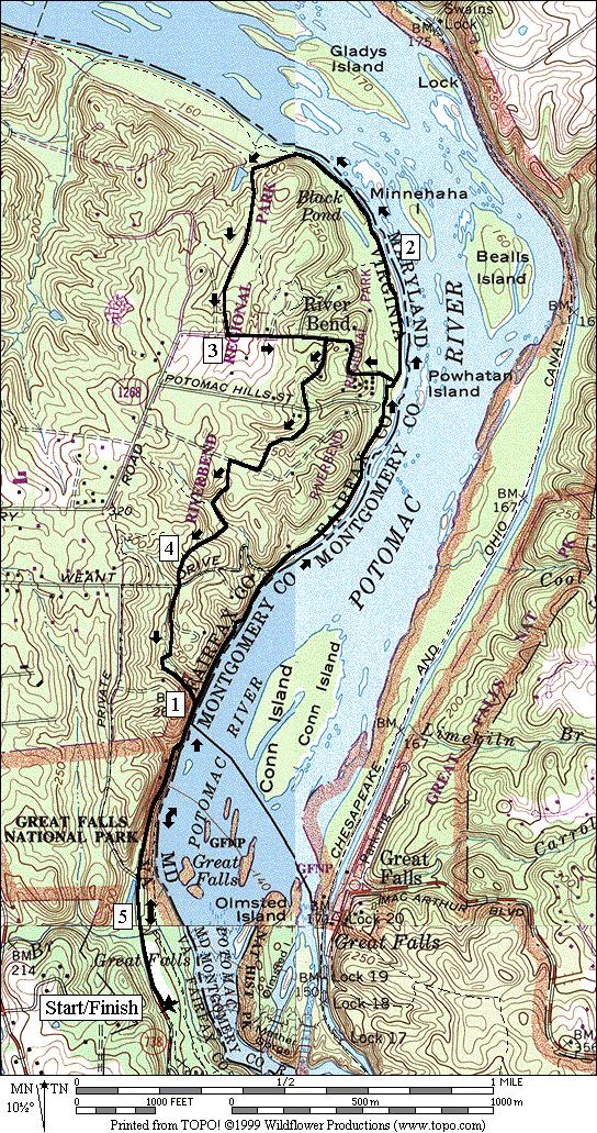
1 Great Falls National Park, Virginia Despite having grown-up in the area, I had not seen Great Falls until I was near an adult. I used to think places like Great Falls only existed someplace else that you went to go on vacation to see. Some are still undecided on whether I m an adult or not but I sure feel fortunate to have Great Falls so close by. The waters tumble 76 feet over the space of about half a mile. The drop confounded people like George Washington who dreamt of transportation and commerce on the Potomac River. The dreamers of his day did something about it by building canals on both sides of the river; at Great Falls, and in other places. The longer and more famous Chesapeake and Ohio Canal was built in Maryland. The Potowmac Canal was built on the Virginia side of the river and passes through Great Falls. The Potowmac Canal was active from 1785 to 1828 but it wasn t completely finished until Restoration efforts have been underway to reset the lock stones on the eroded hillsides. If you have time, hike the River Trail. It s much too rocky to consider running it, but you ll get great views of Mather Gorge, an east coast equivalent of a canyon. The rock walls drop vertically feet straight into the river while the river is compressed to a width hardly more than 100 feet across in some places. Climbers and kayakers of all skill levels take pleasure on the walls and in the water (sometime both). Great Falls is very busy on weekends and there is a modest fee to enter the park. Come early to ensure that you can get in. North and adjacent to Great Falls National Park is Riverbend Park, a Fairfax County park. You can watch the river tumble over lessor boulders there but also find quieter places for contemplation. Getting There From the Capital Beltway, I-495 Take Exit 13, for Georgetown Pike, Rte. 193, west. After four and a quarter miles, turn right at the stoplight onto Old Dominion Dr. and into Great Falls National Park. Near the bottom of the long hill, pay the entrance fee and continue straight. Park in the lot one-tenth of a mile ahead on the right, near the Visitor Center. Start from the crosswalk on Old Dominion Dr. Area Routes Old Carriage Road (3.0, 1.8 or 2.8 miles, II, I, or II) For a quick introduction to the area, follow the bluestone path along Old Dominion Rd toward the entrance gate. Bear left with it as it curves away from the paved road and widens. Where it leaves the road, is where the Old Carriage Rd. begins. There are many branching trails going to and from parking lots and the fall view points. Stay along the widest path and generally keep straight. Follow the signs toward the restrooms, then bear right after them at the intersection with the Matildaville Trail on the left. You re still on the Old Carriage Rd. at this point. Options to shorten the route are at left turns at the next two intersections with the Matildaville Trail (no bikes). If you go to the second left turn, you ll be able to see a little of the Mather Gorge, some of the remains of the Potowmac Canal, a quarry. The shorter and longer return routes on the Matildaville Trail pass by the ruins of Matildaville itself, an old settlement that the park brochures describe as having been sponsored by ighthorse Harry a revolutionary war hero and friend of George Washington. Preservation efforts are underway for Matildaville. The longest
2 route skips the Matildaville Trail altogether. Instead it climbs moderately on the Ridge Trail to Old Dominion Drive and returns on the road. There are no shoulders to the road so you ll need to keep an eye and ear open for traffic. The 3 mile version of this route can be ridden by mountain bike. Weant Drive (2.65 miles, II) Going past the end of the paved Old Dominion Drive, you leave the national park on a gravel road going into River Bend Park. Several park trails branch off along this road. At the top after a climb of 150 vertical feet in seven tenths of a mile, turn right at a T-intersection onto Weant Drive. The quiet drive descends the 150 feet in less than half a mile to the river. Where it reaches the water can be seen Conn Island. Though the island has a name that makes it sound like the latest blockbuster, its fame was a factual drama. A park placard indicates President James Madison having sought refuge there on August 25, He took a ferry there from Montgomery County while trying to flee the British who had set to burning the Capitol. The way to run back from here is on the Potomac Heritage Trail. Pass the aqueduct dam that is the means of withdrawing much of Washington, D.C. s and Arlington s drinking water from the Potomac. The trail gets rocky near the dam. Follow a bumpy gravel road back to Old Dominion Drive and the Visitor Center parking area. Riverbend (5.2 or 3.95 miles, V or IV) ess explored than in Great Falls National Park but not less fun for running on, are the trails in Riverbend Park. Most important of these is the Potomac Heritage Trail (PHT). This long dirt trail along the river has a start in Rosslyn. There are gaps in parts of it but the whole piece through Riverbend Park is in good shape. Even north of Riverbend the PHT can be followed but it gets harder as it climbs hills at and beyond some pipeline crossings. You won t get that far on this route however. Start by heading north along the river. A rough gravel road will give way to a dirt trail. Near the aqueduct dam, the footing will get rocky but this only lasts a short while. The trail then stays close to the water where you get good views of Conn Island. People fish along here a lot. During the drought of 1999 you could see why. The rocks normally hidden underwater revealed almost a reef of nooks, pockets and other places for fish to hide. The water was low enough when measuring these routes in 1999, that you could almost rock hop your way across the river and stay dry. In the cold winter of 2004, ice floes hid it all. Ignore the side trails that climb away from the water until you reach the Visitor Center (see below) in Riverbend Park. Water and restrooms are available there. At this point you can shorten the route rounding the visitor center and heading across the parking lot to the Center Trail. The road-like natural surfaced Center Trail climbs a little to the Upland Trail. Skipping this, go further another three quarters of a mile along the river. The PHT is over loose sand at one point but this ends soon. The Paw Paw Passage Trail begins your route back. Identify it by a gravel road with a blue blaze that splits off to the left, away from the river. It passes next to Black Pond in the woods. Eventually get to Jeffery Road and take the Center Trail to the Upland Trail. After having been warmed-up on the flats, the Upland Trail is where you ll get your workout. It rolls and turns through the woods. Some hills are a little steep. The trail is well marked. Return on the PHT to Great Falls. Within Riverbend Park, mountain bikes are allowed on the PHT, the Center Trail, and the Upland Trail.


3 Probably because of the rocks near the aqueduct dam, the National Park Service asks people not to ride bicycles on the PHT inside Great Falls National Park. Icy View from the PHT, 2004 Riverbend Visitor Center
4 Nearby and Connecting Zones Difficult Run C&O Canal, Great Falls, Virginia ewinsville Park Reston What to do Afterward Food and Drink Indigo At Great Falls Old Brogue Irish Pub Kabob Place Romantica Deli & Pizzaria Entertainment and Edification Great Falls National Park Riverbend Park Nature Center Great Falls Grange & Old Schoolhouse - assembly hall & one room school house
5 Old Carriage Road Distance: Rating: 3.0, 1.8 or 2.8 miles II, I, or II; bluestone, gravel or dir trails; shady; one hill on the longest route 3.0 Mile Route 0.0 from the parking lot on bluestone trail along Old Dominion Dr 0.1 Old Carriage Rd (unmarked) B 0.25 at trail X; follow signs to restroom 0.35 trail X and restrooms BR 0.4 to stay on Old Carriage Rd; Matildaville Trail on (no bikes) 0.55 Swamp Trail on R 0.85 Swamp Trail on R <* 1.0 Matildaville Trail on (no bikes) <** 1.35 Matildaville Trail on (no bikes) R 1.35 Ridge Trail (unmarked) 1.5 trail X on 1.6 trail X on R to Carriage Trail (no bikes) R 2.0 Old Dominion Dr (! unmarked and no shoulder) 2.85 entrance gatehouse R 3.0 xwalk at Visitor Center parking *1.8 Mile Route 0.85 Matildaville Trail; quarry is /R (pickup cues at mile 2.25 on 2.8 mile route) **2.8 Mile Route 1.35 Matildaville Trail 1.6 trail X on R to River Trail 1.7 at T near canal after small wooden bridge over stream R 1.8 trail X after quarry; Carriage Rd on >* 2.25 gravel road on R merges; Matildaville ruins 2.4 Carriage Rd at restrooms; follow wide path toward Old Dominion Rd BR 2.7 trail along Old Dominion Rd R 2.8 Visitor Center parking

6 Old Carriage Road

7 Weant Drive Distance: Rating: 2.65 miles II; shady gravel roads and dirt trails; parts are rocky and there is one big hill R 0.0 from parking lot ; Old Dominion Dr 0.15 Mine Run Trail on 0.3 follow road up the hill past the gate; last parking lot is on R 0.5 Mine Run Trail on 0.65 River Bend Trail on 0.8 gravel trail on R 0.95 trail on R under telephone lines R 1.05 Weant Dr; pass gates (blue blazes) 1.2 trail X on ; private drive on R 1.3 Upland Trail 1.4 trail X on at switchback R 1.5 Potomac Heritage Trail (PHT); river 1.7 Upland Trail on R 1.95 aqueduct dam; rocks (!); GF Nat Park 2.0 trail becomes rough gravel 2.1 trail X on goes along river R/ 2.35 Old Dominion Dr 2.5 Mine Run Trail on R 2.65 into Visitor Center parking at xwalk
8 Riverbend Distance: Rating: 5.2 or 3.95 miles V, or IV; dirt trails w/rocky and sandy spots; hills in the woods when returning 5.2 Mile Route 3.0 Jeffery Rd (unmarked) R 0.0 from the parking lot onto Old Dominion Dr 0.15 Mine Run Trail on R/ 0.3 last parking on R; toward river on gravel road; becomes Potomac Heritage Trail (PHT) 0.55 trail X on R 0.75 aqueduct dam; rough rocks (!) 1.0 Upland Trail (UT) on (for return) 1.15 Weant Dr on (unmarked; gravel) S R >* 3.15 Center Trail is S as road turns 3.25 Upland Trail (UT) 3.3 trail X on to Visitor Center 3.4 Potomac Hills St (unmarked) 3.6 fire road 3.7 at T to stay on UT 3.75 at trail X on to stay on UT 3.8 trail X on R/ 1.65 R at Potomac Hills St; on paved trail to Visitor Center <* BR 1.7 pass the center then bear R to stay on the PHT; trail is sandy 1.8 trail X on 1.9 trail X on 2.05 trail X on to Nature Center R 2.3 on wooden bridge to stay on PHT at trail X B 2.45 Paw Paw Trail; gravel road; blue blaze 2.55 trail X on R at Black Pond 2.65 trail X on S 2.75 trail X on to creek & Nature Center 3.85 at T after bridge over stream; UT R 3.9 trail X on R; to stay on UT 4.0 at T at top of hill to stay on UT CR 4.1 R Weant Dr; to stay on UT 4.15 at T to stay on UT 4.25 at T at river; PHT 4.5 aqueduct dam; rocks (!); Great Falls National Park 4.65 trail X on follows river R/ 4.9 Old Dominion Rd from parking 5.05 Mine Run Trail on R 5.2 Visitor Parking at xwalk *3.95 Mile Route S 1.7 to Visitor Center parking on paved trail; leave the riverside 1.75 across parking at xwalk & go up the stairs to the Center Trail head (unmarked) 1.8 trail bears R; trail X on 1.95 Upland Trail (pickup cues at mile 3.3 on 5.2 mile route)
9 Riverbend
Difficult Run Stream Valley Park
 Difficult Run Stream Valley Park The more intense mountain bikers have known about for Difficult Run for some time. Equestrians have known it longer. Eight miles of unpaved trail, the Rails to River Trail
Black Hill Regional Park, Little Seneca Lake
 Black Hill Regional Park, ittle Seneca ake ittle Seneca ake, in Black Hill Regional Park, is a reservoir created after a previous drought struck the Washington area. The park is under Maryland-National
Trailside Park, Herndon
 Trailside Park, Herndon Herndon is not the little rail stop it used to be. Like many of the smaller towns around Washington, D.C. Herndon has grown and changed. It even installed it s own little beltway,
Trailside Park, Ashburn
 Trailside Park, Ashburn For an outsider, Ashburn might seem like a follow-up act to eston. It s a large planned community built at the time, outside the known limits of civilization... Vast farm fields
Rock Creek Park, MD - Lake Needwood
 ock Creek Park, MD - Lake Needwood Lake Needwood, is a reservoir located at the end of the north end of the ock Creek hiker-biker trail. At the other end, ock Creek empties into the Potomac iver near Thompson
Eakin Community Park. Getting There
 Eakin Community Park Quiet woods along the Accotink Creek are the hallmark of Eakin Community Park. Actually a string of smaller parks, Eakin is made-up of Mantua Park, Kern Drive Park, Eakin Park, Woodburn
Vienna. Getting There
 Vienna Like its famous and older German namesake, but on a smaller scale, Vienna, Virginia has a charm to it. Becoming increasingly more cosmopolitan, foreign restaurants, bagle and coffee shops line Maple
Jackson Miles Abbott Wetlands Refuge/Fort Belvoir
 Jackson Miles Abbott Wetlands efuge/fort Belvoir Over the course of millions of years the Potomac iver has gradually shifted its course and sediments have filled-in its old river bed. The main river once
Leesburg. Getting There
 eesburg eesburg embodies the historic nature of oudoun County better than does Ashburn. As of 1999, it is on the boundary line of suburbia and the country. It s not only the largest town in oudoun County,
Columbia, Maryland - Village of Owen Brown
 Columbia, Maryland - Village of Owen Brown From the Village of Owen Brown, good trails stretch to other neighboring Columbia villages. Mostly following stream valleys, the trails go to and from schools
Aurora Hills. Getting There
 Aurora Hills Aurora Hills is neighborhood near Crystal City and Pentagon City. Ball fields, ball courts, a very short trail, and a combination ibrary/fire Station are the central pieces of a recreation
Section 7: Pick Up Where You Left Off! S-Tree Road over the Todd Road
 2018 TRACE NOTES Helpful information for your adventure on Section 7 of the Hiker Challenge. Start Point S-Tree Rd. End Point Intersection Todd Rd. / Hale Ridge Rd. WEATHER DECISION Weather Alert!!!! Potential
Lake Artemesia. Getting There
 Lake Artemesia Lake Artemesia is a man-made lake and park located near the confluence of the Indian un, and Paint Branch creeks. A flat 1.3 mile paved path around the lake is popular with walkers, runners
Directions to Frequently Visited C & O Canal Locations
 Directions to Frequently Visited C & O Canal Locations Seneca Creek Montgomery County, Maryland Pass town of Potomac and Falls Road and continue west to Seneca Rd. Turn left on Seneca Rd. and continue
Lava Mountain Trail Distance: Elevation Range: Trail Type: Difficulty: Season: Driving Distance: Driving Time: USGS Maps: Pros Cons
 Lava Mountain Trail Distance: 13.4 miles (including the side trip to North Star Lake) Elevation Range: 5900'-8330' Trail Type: singletrack Difficulty: moderate Season: late June-October Driving Distance:
Stephens State Park Trails
 TRAILS OF ALLAMUCHY MOUNTAIN & STEPHENS STATE PARKS Allamuchy Mountain and Stephens State Parks contain 28 marked trails providing access to diverse landscapes for walking, hiking, biking, bird-watching,
UMASS CROSS-COUNTRY Trails
 UMASS CROSS-COUNTRY Trails 1) EGG (43 min) (A) From Cage proceed to North Pleasant street (by campus pond). Make left and head toward LGRT and pass School of Education. Pass Puffton Apt complex (on left)
CELEBRATE WEST GREENWICH GEOCACHING THROUGHOUT WEST GREENWICH
 CELEBRATE WEST GREENWICH GEOCACHING THROUGHOUT WEST GREENWICH The West Greenwich Land Trust (WGLT) is sponsoring Celebrate West Greenwich, an event designed to celebrate the beauty and history of scenic
Trail Phasing Plan. Note: Trails in the Clear Creek Canyon area (Segments will be finalized in the future to minimize wildlife impacts
 Note: Trails in the Clear Creek Canyon area (Segments 2 5 and a future JCOS connection) will be finalized in the future to minimize wildlife impacts Trail Phasing Plan P Parking 3 Easy Trail Intermediate
San Luis Obispo. Bishop Peak Felsman Loop Eagle Rock Maino Open Space Poly Canyon Poly P Other Areas
 San Luis Obispo Bishop Peak Felsman Loop Eagle Rock Maino Open Space Poly Canyon Poly P Other Areas 1 JCT. ELEV. 72 400 00 0 FELSMAN LOOP GATE LOOP RIDGE 600 FENCE JCT. ELEV. 860 1000 1200 BISHOP PEAK
Hiking Las Vegas.com
 Hike: Mt. Wilson via First Creek Canyon route Trailhead: First Creek marked Distance: 10 miles up and back Elevation gain: 3,400 feet Elevation of Peak: 7,070 feet Time: 7 to 9 hours (up and back) Difficulty:
Tiger Mountain State Forest:
 98 60 hikes within 60 miles: SEATTLE 20 Tiger Mountain State Forest: West Tiger Mountain Three Loop i KEY AT-A-GLANCE INFORMATION Length: 5.1 miles round-trip Configuration: Loop Difficulty: Moderate difficult
This path goes past an old tree nursery and sawmill. After 800m it crosses over a lane. Follow the bridleway fingerpost into the woods.
 FRENSHAM PONDS 11K CIRCULAR TRAIL 2½ HRS GU10 2DA This magnificent heathland trail starts in woodland and then brings you out onto the open heather of Frensham Common, with no roadwork! The route runs
Leaden Boot Challenge ROUTE INSTRUCTIONS
 Leaden Boot Challenge ROUTE INSTRUCTIONS Section 1 Alstonefield to Ilam From the village hall car park turn R then L and pass through the village keeping to the R to enter Church Street. Pass the Church
Beautiful Walks from the Blue Ball Inn
 Walk No. 5 RIVER VALLEYS AND MOOR Countisbury, Watersmeet, Hillsford Bridge, Cheriton, Shilstone Hill, Rockford and Chiselcombe. 8.5 MILES APPROX. Walking time four and a half hours approx. OS 1;25,000
Asheville & WNC Hikes
 Asheville & WNC Hikes Amazingly, we have 3,000+ miles of free public hiking trails near Asheville, including 1,600 miles in the Pisgah and Nantahala National Forests, 850 miles in Great Smokey Mountains
Mersey Valley Timberland Trail
 Route Pack Page 1 Route Summary A long distance linear walk on roads and country paths linking town and countryside to parks, woodlands and other open spaces. Grade Distance Accessibility Allow Start Map
Leaden Boot Challenge 2016 ROUTE INSTRUCTIONS
 Leaden Boot Challenge 2016 ROUTE INSTRUCTIONS Section 1 Alstonefield to Ilam (CP2) From the village hall car park turn R then L and pass through the village keeping to the R to enter Church Street. Pass
Crystal Lake Area Trails
 Lake Area Trails Welcome to the Lake area of the Big Snowy Mountains! This island mountain range in central Montana features peaks reaching to 8,600 feet and long, high ridges from which vistas of the
Sponsored by. statestreet.com
 /STATESTREETISLANDWALK #ISLANDWALKJSY Sponsored by statestreet.com Important Information If you forget everything else PLEASE remember the following.» Remember to check OUT of every checkpoint» If you
The Croatan MST Segment 16B
 1 Mountains-to-Sea Trail Last Updated 1/1/2017 A sandy road through longleaf pine savanna in the Croatan National Forest Photo by PJ Wetzel, www.pjwetzel.com The Croatan MST Segment 16B STELLA TO THE NEUSIOK
C E N T R A L C A T S K I L L S
 120 C E N T R A L C A T S K I L L S Central Catskills Once out of the southern parts of the Catskills, the Long Path enters the more well traveled and civilized regions. The trail joins the Devil s Path,
Matthiessen State Park Dells Area Hike
 90 Easy Hikes Close to Home At the south end of the hike, you ll climb on top of a mound left over from a former coal-mining operation in the park. Not far from Goose Lake Prairie, the town of Morris hosts
playwinterpark.com Off The Beaten Path Hikes Hiking Recommendations for the Adventurous Hiker
 playwinterpark.com Off The Beaten Path Hikes Hiking Recommendations for the Adventurous Hiker Hike: Devil s Thumb (difficult) Length: 3.93 miles one-way Elevation: Trailhead 9609 Destination 12,236 Trailhead
Telluride-to-Moab Alternative Singletrack Options
 Telluride-to-Moab Alternative Singletrack Options Day 1 Day 1 Alternate 1: Galloping Goose to Deep Creek. 18.4 miles, ascent 3,530ft, descent 1,388ft. This is fun, flowey, moderate to intermediate singletrack
Androscoggin River Trail Access Sites. North Woods. 168 miles from its source at Lake Umbagog to Merrymeeting Bay
 Androscoggin River Trail Access Sites North Woods 168 miles from its source at Lake Umbagog to Merrymeeting Bay Trail Under Construction More than 40 Public Access Sites Available Androscoggin River Watershed
beach. Make the ford and follow the trail out to the junction with Red Creek Tr in an open grassy area.
 Description: This is a moderate to slightly strenuous 22.8 mile backpack (add 2.6 miles if you do the packless out and back to the Lion s Head) that will have you exploring nearly every thing that is The
GOLDEN EARS PROVINCIAL PARK
 GOLDEN EARS PROVINCIAL PARK Trail Information as of October 10 th 2015 Do not underestimate the mountainous wilderness of Golden Ears Provincial Park. The combination of rugged terrain and rapidly changing
Foxhill Park, Bowie, Maryland
 Foxhill Park, Bowie, Maryland The approximately 50,000 residents of the city of Bowie, Maryland are proud of the trails that link the city. Many trails exist and many are planned. Bowie is a changing city.
START - UPHILL BEACH. (tidal!) The West Mendip Way is route-marked with these round blue signs
 The West Mendip Way is route-marked with these round blue signs") START - UPHILL BEACH Start Times: 10:30 11:15 12:00 Please allow sufficient time to check in with the marshals Start on the beach at the high water line (tidal!) The West Mendip Way is route-marked with
START - UPHILL BEACH Start Times: 10:30 11:15 12:00 Please allow sufficient time to check in with the marshals Start on the beach at the high water line (tidal!) The West Mendip Way is route-marked with
Tom's Run 2018 Course Map. Fairfield Inn and Suites 21 N Wineow Street Cumberland, MD Phone:
 Tom's Run 2018 Course Map Fairfield Inn and Suites 21 N Wineow Street Cumberland, MD 21502 Phone: 1-301-722-0340 Useful Information National Park Service C & O Canal Web site: http://www.nps.gov/choh/index.htm
CIEC 9 PEAKS AWARD SUPPLEMENT POSSIBLE ROUTES FOR THE 9 PEAKS AWARD TRIP
 CIEC 9 PEAKS AWARD SUPPLEMENT POSSIBLE ROUTES FOR THE 9 PEAKS AWARD TRIP As you plan your trip, be aware of 3 regulations in this wilderness: 1. Camp only in designated campsites. 2. No campfires allowed.
COURSE DESCRIPTION AND DIRECTIONS
 COURSE DESCRIPTION AND DIRECTIONS START TO BOUNTIFUL B (MILE 0 to MILE 17.05) From the start at East Mountain Wilderness Park, go past the green metal gate of East Mountain Wilderness Park and follow the
Route #1) Mt. of the Holy Cross - North Ridge
 Mt. of the Holy Cross - North Ridge") Climbing 14ers can be very dangerous, please read the Mountaineering Safety Page and make sure you have a map+compass and can use them effectively, without the help of electronic devices. Route #1) Mt.
Climbing 14ers can be very dangerous, please read the Mountaineering Safety Page and make sure you have a map+compass and can use them effectively, without the help of electronic devices. Route #1) Mt.
CRANBERRY. Introduction
 Introduction Introduction The Cranberry Boulders are a group of 60 problems set in a beautiful mossy forest above the Cranberry Creek. The boulders are located approximately 36km south of Revelstoke on
Potato Chip Grinder. Sheet1
 Potato Chip Grinder MILE DIRECTIONS FOR 0 START: Albertsons 5 Woodland Pkwy San Marcos, CA. (OPEN:00:00 CLOSE:+0:00) Obtain proof of start from local business with time & date stamp. Exit parking lot toward
LOWER SPRING CANYON - CAPITOL REEF
 LOWER SPRING CANYON - CAPITOL REEF Rating: Moderate Hike Length: 5-7 hours (10-11 miles) Gear: Standard Hiking Gear Maps: Fruita, UT; Twin Rocks, UT; Water: A filterable spring a bit over 1/2 way. Recommend
SOL VS.2a, 2b, 2c, 10b
 What are the characteristics of the Coastal Plain? 1. Also known as Tidewater 2. Located near the Atlantic Ocean and the Chesapeake Bay 3. Includes the Eastern Shore, a peninsula between the Atlantic Ocean
The gorges of Mohican Park in Ohio create a hiker's paradise Sunday, May 22, 2011 By Bob Downing, Akron Beacon Journal
 Pittsburgh Post-Gazette The gorges of Mohican Park in Ohio create a hiker's paradise Sunday, May 22, 2011 By Bob Downing, Akron Beacon Journal Bob Downing Big Lyons Falls drops 80 feet into a shady U-shaped
Southern Utah University Hike Brochure
 Southern Utah University Hike Brochure Taylor Creek Trail Twenty minutes from Cedar City Red Hollow An hour and a half from Cedar City Fees: Entrance fee to Kolb Canyon Length: 5 miles round trip Length:
Berowra Waters to Cowan Station
 Berowra Waters to Cowan Station 3 hrs 30 mins 7.2 km One way Hard track 597m This is a hilly walk out of the beautiful Berowra Waters valley to Cowan Station. There are many wide views across Berowra Creek
Bikes talk to each other like dogs, they wag their wheels and tinkle their bells, the riders let their mounts mingle.
 Bikes talk to each other like dogs, they wag their wheels and tinkle their bells, the riders let their mounts mingle. Daniel Behrman, The Man Who Loved Bicycles W hitmore Lake Loop route: Dexter, the corner
The Cleo s Bath North Side Hike
 The Cleo s Bath North Side Hike This hike is a cross-country hike from Pinecrest Lake to the north side of Cleo s Bath. It is quieter and much less crowded than the normal route, which goes up the south
CWMGIEDD FROM ABERCRAVE
 Abercrave to Cwmgiedd Walk Page 1 Starting from The Abercrave Inn. Grid Ref: SN 824128 From the Abercrave Inn, an 11.3km (7 miles) walk to the foothills of the Cribarth Mountain, then through forest to
Hiking Trail Descriptions
 Hiking Trail Descriptions For ye shall go out with joy. And be led forth with peace. The mountains and the hills shall break forth before you in singing. And all the trees of the fields shall clap their
Darwin s gigantic blunder
 Trail Darwin s gigantic blunder Explore how ice shaped the landscape and why Charles Darwin made a nice mess of Glen Roy Time: 1hr 10 mins Distance: 2 miles Landscape: rural At Glen Roy a curious feature
Charnley Explorer June 24 - July 15, 2018 Bachsten Creek and the Charnley River. Second draft: 14 November 2017
 Charnley Explorer June 24 - July 15, 2018 Bachsten Creek and the Charnley River. Second draft: 14 November 2017 The best part of the original section one is now part of out Gibb Road Gorges trip. The dates
Cincinnati Nature Center s
 120 60 hikes within 60 miles: cincinnati 24 Cincinnati Nature Center s Rowe Woods i KEY AT-A-GLANCE INFORMATION Length: 8.9 miles Configuration: Loop Difficulty: Difficult Scenery: Forest, ponds, prairie,
Photographing Upper Peninsula Waterfalls
 Photographing Upper Peninsula Waterfalls Tod Poirier Freelance Photographer Photography is one of my passions. The following spread showcases several Upper Peninsula waterfalls. At times a single drop
CONTENTS. 31 THE TRAILS See next page for a complete listing of all trails and a locator map. Trail descriptions begin on page 31.
 CONTENTS Page Topic 6 Trail List 7 Trail Locator Map 8 Trails Listed by Dificulty 9 Trail Ratings Deined 11 INTRODUCTION 11 Using this Book 12 The Right Trail for You 13 About Moab 15 Utah OHV Laws and
Route Combo) Mt. Bierstadt - Bierstadt, Sawtooth, Evans
 Mt. Bierstadt - Bierstadt, Sawtooth, Evans") Climbing 14ers can be very dangerous, please read the Mountaineering Safety Page and make sure you have a map+compass and can use them effectively, without the help of electronic devices. Route Combo)
Climbing 14ers can be very dangerous, please read the Mountaineering Safety Page and make sure you have a map+compass and can use them effectively, without the help of electronic devices. Route Combo)
Greenbush Town Hall / Fire Station
 Page 1 of 18 Course Description Greenbush Town Hall / Fire Station Both races start in front of the Greenbush Town Hall / Fire Station, just south of Highway 23 on Sugarbush Road. Parking will be in the
Ystwyth and Rheidol Bridleway Routes. Route 2:Llanilar Circular
 Ystwyth and Rheidol Bridleway Routes Route 2:Llanilar Circular Route overview and terrain: A long circle using connecting ridges with fine views to link the Rheidol and Ystwyth river valleys. The route
BISHOPSTONE CIRCULAR WALK
 BISHOPSTONE CIRCULAR WALK 4½ miles (7¼ km) - allow 2 hours (see maps on final pages) Introduction This walk is within the North Wessex Downs Area of Outstanding Natural Beauty and starts from the small,
AOTA ArtTrek Locations
 AOTA ArtTrek Locations ArtTrek is a summer-long Grand County, CO art adventure. Highlighted by snow-covered mountain vistas and rolling meadows threaded with sparkling streams and rivers, numerous sites
1. Waterfall Gully Mt Lofty. 5 Of the Best Hikes in Adelaide
 Adelaide is a beautiful city, and one of the most incredible things about Adelaide is the quality of bushwalking available on the suburban fringe. It is surrounded by the Mt Lofty Ranges, and much of the
Culpeper District. Albemarle County Monthly Report. September 2012
 Culpeper District Albemarle County Monthly Report September 2012 Special Issues Bridges on Route 745, Arrowhead Valley Road The road will be closed at the Rail Road Bridge on the southern end of the road
Piestewa Peak/Dreamy Draw Trail Guide
 Piestewa Peak/Dreamy Draw Trail Guide Trail #1A - Perl Charles Memorial Trail Length: 4.8 miles Elevation: 2,200 ft. - 1,340 ft. Difficulty: Moderate to difficult The Perl Charles trailhead is located
INTERMEDIATE. mayorsmtbchallenge.org
 mayorsmtbchallenge.org Redding s second local Mountain Bike Challenge uniting current and new bicyclists in a friendly self-competition highlighting our diverse trail system. INTERMEDIATE Mule Ridge Cosmos
Staunton River Trail to Hoover Camp and Fork Mtn. Relay Tower (Based on September 18, 2013 hike by Ron Singleton, Fredericksburg, Va.
 Staunton River Trail to Hoover Camp and Fork Mtn. Relay Tower (Based on September 18, 2013 hike by Ron Singleton, Fredericksburg, Va.) The President's Cabin (The "Brown" House) at Camp Hoover. Sign on
Beaver Creek State Park
 GENERAL INFORMATION Name of Park/Forest/Facility: Beaver Creek State Park County: Columbiana (St. Clair Township) Address: 12816 Sprucevale Road (ie County Rd 428) (street #, city) East Liverpool, Ohio
S H A W A N G U N K R I D G E T R A I L
 214 Shawangunk Ridge Trail The Shawangunk Ridge Trail was originally conceived as a relocation of the Long Path from Harriman State Park to Minnewaska State Park. Now part of the Long Path system, the
SECTION 1: MARYLAND TO PA nd CROSSING MASON DIXON LINE TO RAINSBURG GAP BUCHANAN STATE FOREST, PRIVATE LAND, SGL 97
 SECTION 1: MARYLAND TO PA 326 2 nd CROSSING MASON DIXON LINE TO RAINSBURG GAP BUCHANAN STATE FOREST, PRIVATE LAND, SGL 97 Web Update, August 2010 http://www.hike mst.org Section 1 follows Tussey Mountain
Baltimore County Nature Quest NEW TRAILS 2014
 Baltimore County Nature Quest NEW TRAILS 2014 Nature Quest Park Locations Robert E. Lee Park Cromwell Valley Park Agricultural Ctr. & Farm Park Honeygo Regional Park Marshy Point Park and Nature Center
Drive and Stop Routes
 Drive and Stop Routes Limantour Road 1 - easy and likely productive. From Bear Valley Visitor Center drive back out and turn left onto Bear Valley Rd. Turn left at Limantour Road (the first road). Drive
Discovering the Trails of Prince George s County
 Discovering the Trails of Prince George s County Happy Trails! Since 2005, Wegmans has been partnering with town and city recreation programs and park conservancy groups to encourage folks to get moving
Griffith Park Trail Run Trail Guide Click for
 The Griffith Park Trail Run by Hike- LosAngeles.com Griffith Park Trail Run Trail Guide Click for downloadable cell phone guide and map from EveryTrail. DISTANCE: 4.55 Miles ELEVATION: 1280' ELEVATION
Great Eastern Trail Newsletter
 Great Eastern Trail Newsletter Volume 1, Number 1, January 2011 By Timothy A. Hupp Please feel free to print out or copy and distribute this newsletter Note this is the first newsletter of the Great Eastern
The Mendip Way. Route Directions and Maps Uphill to Wells
 The Mendip Way Route Directions and Maps Uphill to Wells Website: www.mendiphillsaonb.org.uk Email: mendip@mendiphillsaonb.org.uk Facebook & Twitter: @MendipHillsAONB Phone: 01761462338 1 Uphill to Loxton
Glacial Geomorphology Exercise
 James Madison University Field Course in western Ireland Glacial Geomorphology Exercise 3-day road log (abbreviated) Striations Large kame terrace Cirque with moraines Kame delta Striations Eskers Raised
Trail Assessment Report
 Trail Assessment Report Trail Options for the Bear Creek Canyon located in Pikes Peak Ranger District, Pike National Forest and on Colorado Springs Utility Lands Due to the presence of a unique species
Bike Routes of Sault Ste Marie 2017
 Bike Routes of Sault Ste Marie 2017 East Portage - Riverside - Nicolet - Scenic (15-20 miles, mostly flat) Proceed east on Portage Ave. Portage Ave becomes Riverside Drive at Mission Rd. Portage is a wide
Trekking at Peuma Hue
 Trekking at Peuma Hue Peuma Hue is a paradise for those who love hiking and trekking. A large variety of trails cross pristine forest, ancient rocks and stunning waterfalls with beautiful views over the
Visitor s Center 110 E. Meeting Street Morganton, NC
 5 unique trails worth checking out! Cross-Country skiing! No snakes! Don t sweat it! www.discoverburkecounty.com Visitor s Center 110 E. Meeting Street Morganton, NC Photo of Table Rock by Justin Costner
Trail Beginning Elevation: 7553 ft The Poison Creek Trailhead is located at the end of National Forest Road 646E (NF-646E).
.") West Mountain Trails Poison Creek Trail #134 Length: 2.9 miles (4.7 km) Difficulty Horseback: A good trail for the first time west mountain rider, some steep sections Hiking: Most Difficult USGS Maps:
West Mountain Trails Poison Creek Trail #134 Length: 2.9 miles (4.7 km) Difficulty Horseback: A good trail for the first time west mountain rider, some steep sections Hiking: Most Difficult USGS Maps:
Split Point Lighthouse Aires Inlet
 www.greatoceanroad.vc Great Ocean Road Three Day Tour 2 Night Stay This three day trip of approximately 730 kilometre starts from Melbourne and provides a good overview of features along the Great Ocean
OMH Trail Data / History
 Lake Sylvia Loop Ouachita National Forest (AR) This is a five-mile loop with several variations for Saturday hikes. The basic loop starts at Lake Sylvia campground and goes south to meet the Ouachita Trail
Wicklow Mountains Path Survey
 Wicklow Mountains Path Survey Glenmacnass Tonelagee Start to Finish: O 114 030 to O 085 016 Altitude (lowest highest): 370m 817m Weather: Sunny day, hot Access: Military Road, Glenmacnass Surveyed by:
BRR Leg 1 (3.9 miles, Easy)
") BRR Leg 1 (3.9 miles, Easy) Min 3901 Max 4919 Ascent +21 Descent -1031 0.0 Start (Grayson Highlands State Park Visitor Center) 3.9 Grayson Highlands State Park Office & Gate, on R (EZ 1) Leg Notes: Minimal
BRR Leg 1 (3.9 miles, Easy) Min 3901 Max 4919 Ascent +21 Descent -1031 0.0 Start (Grayson Highlands State Park Visitor Center) 3.9 Grayson Highlands State Park Office & Gate, on R (EZ 1) Leg Notes: Minimal
Route #2) Mt. Massive - Southwest Slopes
 Mt. Massive - Southwest Slopes") Route #2) Mt. Massive - Southwest Slopes Difficulty: Class 2 Ski: Advanced, D6 / R2 / III Exposure: Summit Elevation: Trailhead Elevation: Elevation Gain: Round-trip Length: Trailhead: County Sheriff:
Route #2) Mt. Massive - Southwest Slopes Difficulty: Class 2 Ski: Advanced, D6 / R2 / III Exposure: Summit Elevation: Trailhead Elevation: Elevation Gain: Round-trip Length: Trailhead: County Sheriff:
MOAB peopleforbikes.org/e-bikes
 emtb ADVENTURE MAPS MOAB peopleforbikes.org/e-bikes OVERVIEW Moab, Utah is a world-class mountain bike destination known for its vast, red sandstone landscapes nestled below the rising peaks of the La
H U D S O N P A L I S A D E S
 14 H U D S O N P A L I S A D E S Hudson Palisades The southernmost sections of the Long Path follow the Hudson River and the Hudson Palisades north, staying close to the river and to civilization. Although
(west) onto Charleston Boulevard. Drive 16 miles on Charleston and turn right into Red Rock
 onto Charleston Boulevard. Drive 16 miles on Charleston and turn right into Red Rock") Hike: North Peak and Ice Box Overlook up and back Trailhead: 2.5 miles up the Rocky Gap Road not mark Distance: 5 miles round trip Elevation gain: 2,694 feet Elevation Peak: 7,094 feet Time: 3 to 5 hours
Hike: North Peak and Ice Box Overlook up and back Trailhead: 2.5 miles up the Rocky Gap Road not mark Distance: 5 miles round trip Elevation gain: 2,694 feet Elevation Peak: 7,094 feet Time: 3 to 5 hours
NATIONAL ATV / UTV JAMBOREE RIDES
 NATIONAL ATV / UTV JAMBOREE RIDES Note: Rides range from Beginner to Advanced and will last from 2 to 3 hours or an entire day of riding. 1. DESERT RIDE (CLEAR LAKE BIRD REFUGE & LACE CURTAINS/LAVA TUBES)
Lordenshaw. What are cup & ring marks?
 Lordenshaw Lordenshaw hill has one of the largest clusters of ancient cup and ring marked stones in the UK. We ve chosen four interesting spots we d like to share with you. What are cup & ring marks? The
ATACAMA CROSSING 2008 COURSE HANDBOOK STAGE 1. CP1 CP2 CP3 CP4 camp 2 Total Difficult Moderate Moderate km km 8.38 miles. 7.
 Camp 1: Rock Carvings Camp 2: Inca (On the edge of the slot canyons) 1: Navigation by Rock Altitude, rolling hills, flat out landscape. CP2 and Piedra de los cocas hieroglyphs Inca influence - side of
BG Peter D. Hidalgo (Retired) Internment at Arlington National Cemetery, Virginia
 Internment at Arlington National Cemetery, Virginia") BG Peter D. Hidalgo (Retired) Internment at Arlington National Cemetery, Virginia SERVICE Date: Tuesday, February 17, 2009 Time: 1100 Please arrive at Arlington National Cemetery by 10:30 and proceed to
BG Peter D. Hidalgo (Retired) Internment at Arlington National Cemetery, Virginia SERVICE Date: Tuesday, February 17, 2009 Time: 1100 Please arrive at Arlington National Cemetery by 10:30 and proceed to
Reigate Hill and Gatton Park
 point your feet on a new path Reigate Hill and Gatton Park Distance: 11½ km=7 miles easy-to-moderate walking or 2 walks of 6½ km=4 miles and 5½ km=3½ miles Region: Surrey Author: Schwebefuss Refreshments:
BRYCE CANYON COUNTRY Boulder Mountain Scenic backways itinerary
 BRYCE CANYON COUNTRY Boulder Mountain Scenic backways itinerary Boulder Mountain Area The high plateaus of the Aquarius Plateau (Boulder Mountain), are heavily forested and covered in countless winding
SIMON CANYON AREA OF CRITICAL ENVIRONMENTAL CONCERN (ACEC)
") SIMON CANYON AREA OF CRITICAL ENVIRONMENTAL CONCERN (ACEC) Activities: Facilities: Season / Hours: Description: Hiking, backpacking, fishing, picnicking, watchable wildlife. A graveled parking area, picnic
SIMON CANYON AREA OF CRITICAL ENVIRONMENTAL CONCERN (ACEC) Activities: Facilities: Season / Hours: Description: Hiking, backpacking, fishing, picnicking, watchable wildlife. A graveled parking area, picnic