Town of Wethersfield Trail Guide
|
|
|
- Nathaniel Powell
- 6 years ago
- Views:
Transcription

1 Town of Wethersfield Trail Guide Heritage Trail Day April 25 th 2009
2 Central Connecticut Health District 505 Silas Deane Highway (860) Phone Wethersfield, CT (860) Fax Presented by The Central Connecticut Health District Connecticut Department of Public Health Town of Wethersfield Metropolitan District Commission Wethersfield Health Care Center Prepared by Jessica P. McMullin 1
3 Table of Contents Introduction Map Legend Heritage Way Bike Path Reservoir Trail Mill Woods Park Wintergreen Woods Broad Street Green Loop Old Wethersfield/Historic District NHTSA Tips Smart Dining Restaurants Thank Yous References
4 Introduction Thank you for attending Wethersfield s First Annual Heritage Trail day, and congratulations on taking steps to pursue a healthier lifestyle. This guide includes all of the marked walking and biking trails in Wethersfield, Connecticut. Each of the trails was assessed based on criteria from the National Traffic Highway Safety Administration 1, in an effort to make local communities more walker and biker friendly. The scores are presented after the trail name and are shown in total points out of a possible 30, and also as a percentage. After the trail descriptions, there are suggestions about what you can do on a local level to make your community or neighborhood more walkable and bikeable. A list of our Smart Dining in the District Restaurants is also included in the guide. These are restaurants that have taken steps to make their menu choices healthier without sacrificing the tastes you enjoy while dining out. Thank you for your participation and have a great walk or bike ride! 3
5 Map Legend = Walking Trail = Heritage Bike Path Ρ = Parking Area = Biking Allowed = Walking Allowed = Pets Allowed = Sites to See = Boat Launch Available Note: All distances noted in the assessment are approximations only! 4
6 5
7 6
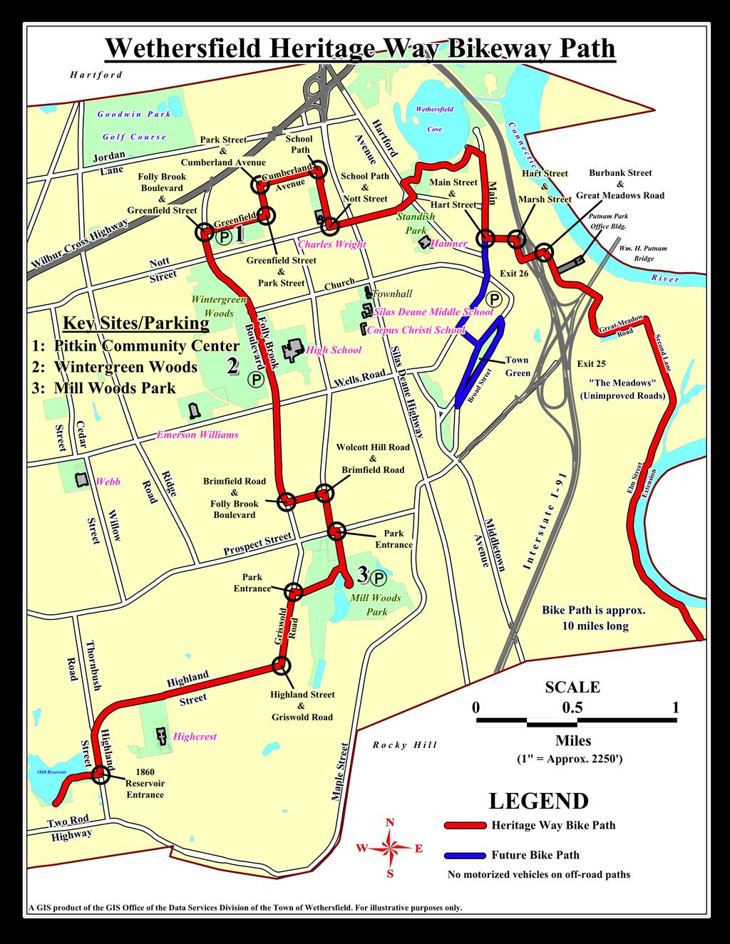
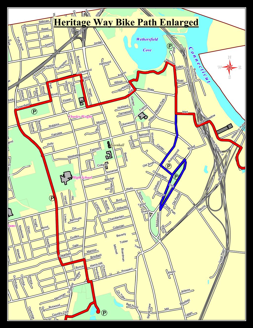
8 Heritage Way Bike Path Bike-ability Score: 27/30 = 90% Many portions are appropriate for walking also. Please see individual trail assessments that are part of the Heritage Way Bike Path. Distance: Just under 10 miles. Parking: Parking is available along the trail at Mill Woods Park, Wintergreen Woods, and William J. Pitkin Community Center. The trail goes through most of Wethersfield; if possible, try to safely ride to the trail from home. Sites to see: Highlights of the Heritage Trail include peaceful forests along the Folly Brook portion of the trail, as well as a beautiful water view as the trail approaches Cove Park. Also, please see individual trail assessments for more sites to see along paths that are part of Heritage Trail. Traffic / Crosswalks: Overall, the crosswalks are easy to use along Heritage Trail. Two areas are of note: 1) When leaving Mill Woods Park heading north, it is easier to stay in the crosswalk, because if you follow traffic, you turn left and then have to take a quick right. 2) Along the Folly Brook portion of the trail, there are several areas where the trail crosses road traffic. There are crosswalks available, but crossing traffic does not have a stop sign, so please use caution. The path turns frequently in the portion after Greenfield Street. First, you have to turn left on Park Street, but it is one way going right. Bikers can go around the circle to continue left. Then pay close 7
.")
9 attention to the map because the trail follows some paths that are not always marked. Keep your eyes open! After Nott Street, use caution and the traffic signal to cross the busy Silas Deane Highway. Most of the turns in the trail are marked with green Bike Route signs, but not all of them are. Please follow the map! Terrain: The trail starts at the 1860 Reservoir (see separate trail assessment). It then follows street roads until you read Mill Woods Park. This portion of the trail is gravel and travels between the park s sports fields. The Folly Brook portion of the trail is relatively flat and covered with gravel. Much of the trail is flat with some slight hills. There is usually no marked bike lane on the road, but in many areas the road was smoother and easier to use than the sidewalks. The last part of the trail goes through the area in Wethersfield known as the Meadows. It is a wide unpaved path, appropriate for mountain bikes. There is little to no car traffic at this point of the biking trail. Special Considerations: This trail is nearly 10 miles long. If you are a beginner biker, take frequent stops and do not try to bike it all at once. It can be enjoyed just as well in portions. Park Hours: See individual parks throughout the guide. 8
10 9
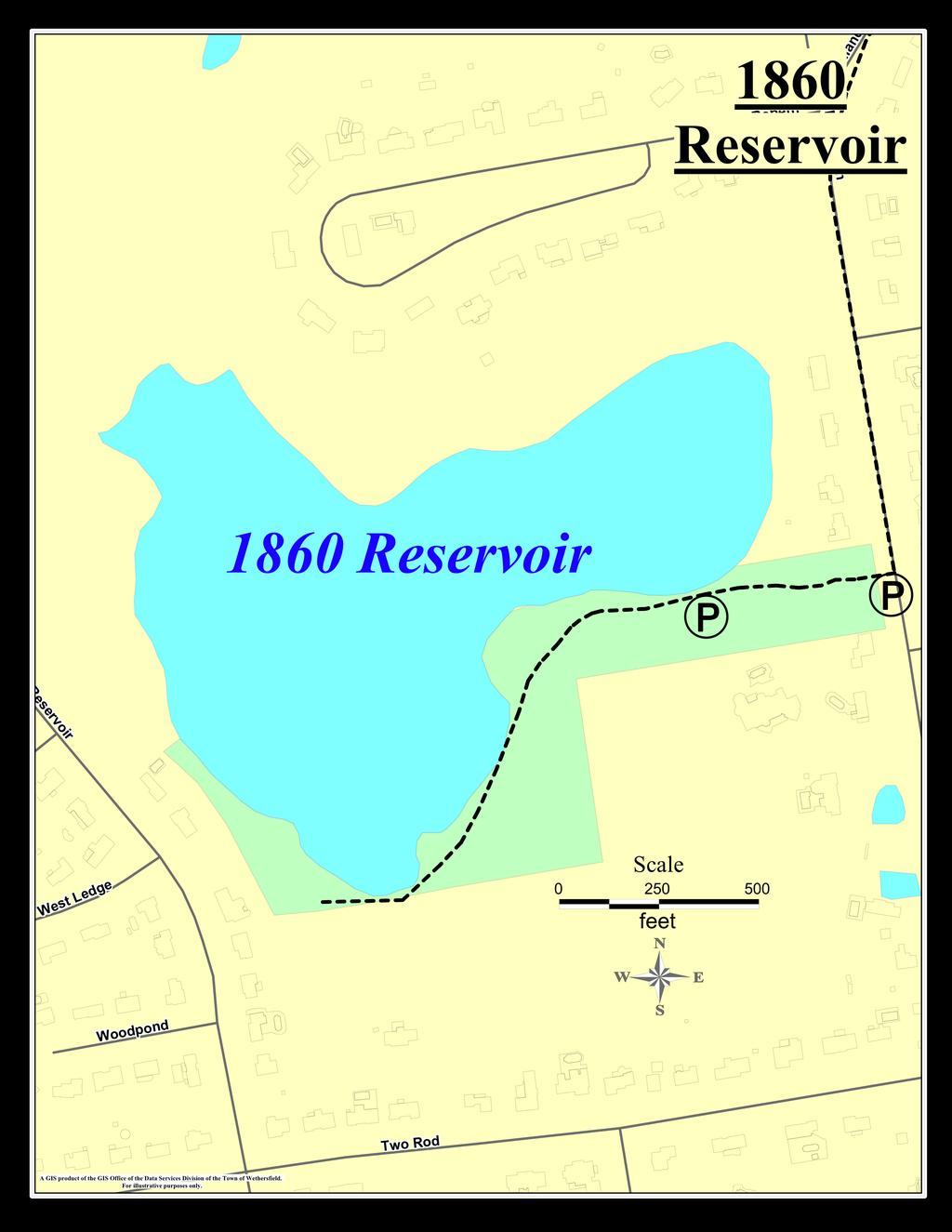
11 1860 Reservoir Trail Walk-ability Score: 28/30 = 90% Bike-ability Score: 27/30 = 93% Distance: 1850 feet or 0.35 miles Parking: Difficult. There is one small area off the side of Thornbush Road, so limited parking on the public road is available. If you drive your car through the gates, there is one small parking area on the left, but driving there takes up a good portion of the short walk. Traffic / Crosswalks: Please be aware of traffic on Thornbush Road when entering the trail because there is a moderate amount of traffic. Terrain: This is a rather rugged trail. The entrance near the main road is a short steep slope. After the slope, most of the road is clear and even, but there are areas that are quite rocky. A mountain bike or light hiking shoes are appropriate. Special Considerations: No handicap accessibility. Park Hours: The gate is open from 8:00AM until sunset. Other: A boat launch is available for canoes or other non-motorized boats. Quiet electric fishing boat motors are allowed. Many consider this peaceful corner of Wethersfield a hidden gem! 10
12 11
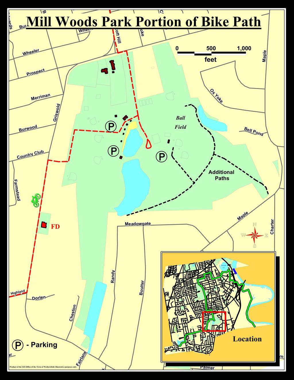
13 Mill Woods Park Walk-ability Score: 27/30 = 90% Bike-ability Score: See Heritage Trail. A portion of Heritage Trail travels through Mill Woods Park. Distance: 4210 feet of walking paths or 0.8 mile. Parking: Ample parking in several different lots. Sites to see: There is a pretty waterfall on the portion of the trail closest to Bell Pond. Traffic / Crosswalks: There is a considerable amount of automobile traffic around the entrance to the parks, especially in the summertime when Mill Woods Pond is open as one of Wethersfield s public pools. To access the walking trails, park near the skate-park or playground. The entrance to the trails is behind the southern most ball field. It is not obvious and one might have to search for it a bit. After about 75 yards, the trail divides. You can head west which takes you by Mill Woods Pond and onto a wider gravel trail, or east will take you to the trail near Bell Pond. To do the whole trail, one must backtrack and redo the eastern portion of the trail. Terrain: The walking trails through the woods are relatively flat. One portion near Bell Pond has a steeper incline. In the early spring the terrain can get muddy. Light hiking boots or at least sturdy sneakers are recommended. 12

14 Toward the western most end of the walk, it is difficult to distinguish where the trail goes. It is a particularly muddy portion of the trail, and one has to walk over a log to stay on the trail. Special Considerations: In addition to the walking trails, Mill Woods offers a dog park, skate park, pond for swimming, soccer fields and a playground. No alcoholic beverages are allowed. Vehicles must stay off the grass. Dogs must be on a leash, except in the dog park. Please clean up after pets. No golfing, dumping or snowmobiles allowed. The park is handicap accessible, but the trails are not. Park Hours: The park is open from 8AM until sunset. Other: This is an easy trail and would be appropriate for school aged children, especially because of its short length and other activities available. 13
15 Notes: 14
16 15
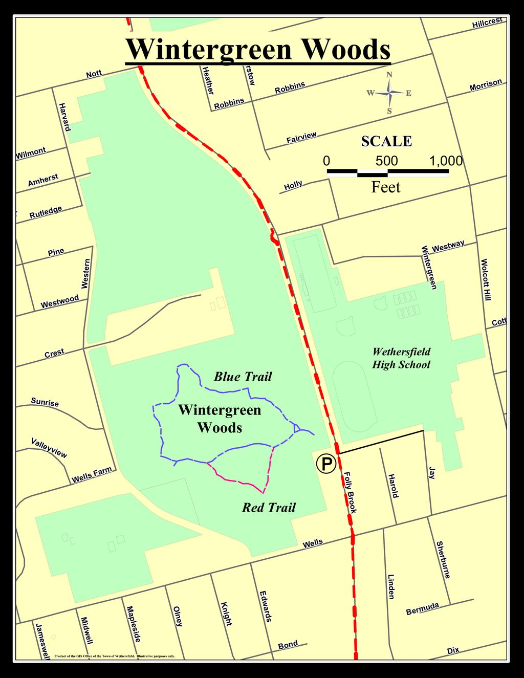
17 Wintergreen Woods Walk-ability Score: 28/30 = 93% Bikes are allowed on the trail, but it is mostly used by walkers and people with pets. Distance: Blue Trail: 3550 ft or 2/3 mile; Red Trail: 1970 ft or 1/3 mile; Total Walk Around: 4080 ft or 8/10 mile Parking: Ample parking available at the trailhead. Sites to see: The western most portion of the trail juts out to an overlook of a pond with lots of wildlife. Traffic / Crosswalks: None Terrain: This is a beautiful nature hike in the middle of a New England Forest. The terrain is relatively easy, but it is considered a hike. There are slight slopes and muddy areas. The trails are very well maintained with wood chips and wooden bridges in the wettest areas. Light hiking boots or sneakers are appropriate. Special Considerations: It is not uncommon to encounter unleashed dogs on this trail. Other: The trail would not be considered handicap accessible. 16
18 17
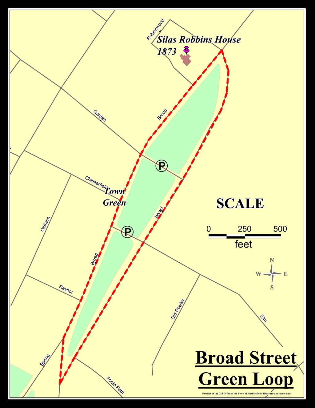
19 Broad Street Green Loop Walk-ability Score: 25/30 = 83% Bike-ability Score: 27/30 = 90% Distance: Just under 1 mile loop (approximately 5230 feet), and can be connected to the Old Wethersfield Walks included in this guide. Parking: Ample parking is available all around the Green and at designated parking spots at cross streets through the Green. Sites to see: This is a beautiful, residential loop around Old Wethersfield s Historic Broad Street Green. There are many historic homes to admire, including the recently renovated Silas W. Robbins House. Originally built in 1873, this house stands on 2 acres of land and now serves as a bed and breakfast after it was almost destroyed by a fire in It is marked by the tack on the map. Traffic: This area, which has light automobile traffic (hardly any during the work week), is a great spot for families with different needs. Older children can even play on the large open green in the center of the loop while other family members walk or bike along the borders. The southern most point of the loop has a bit of a difficult spot to cross at a fork intersection, since there are potentially four lanes of slow traffic to check before crossing, depending on where on the Green you want to cross. Some people choose to use the available sidewalks, but they are older with several uneven spots along the route. Others walk right on the road, which is smoother and more appropriate for any bikes, rollerblades, strollers, or anything with wheels. 18
20 Terrain: In general, the terrain is all paved and relatively flat through residential areas. 19
21 Notes: 20
22 21
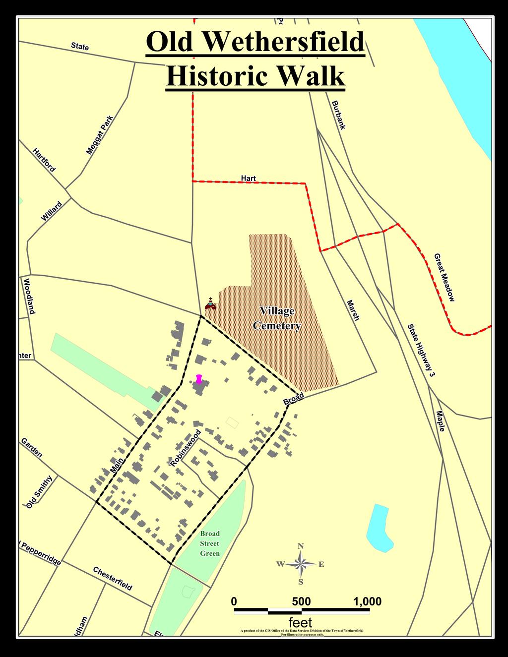
23 Old Wethersfield / Historic District Distance:.92 miles for the Historic District Walk Parking: Available all along Main Street. There is also a large public parking lot behind Keeney Cultural Center and is clearly marked from the main road. **The Historic Commission will be running three guided tours for FREE today to promote Heritage Trail Day.** 10 am Wethersfield Burying Ground The tour meets in the parking lot of the First Church at the Red Barn. This tour highlights the oldest stones in the Burying Ground and addresses stone carvers and iconography. Stories of people who are buried there are highlighted. This walk lasts about 1 hour. There is some light climbing and uneven ground. Comfortable walking shoes are recommended, and the tour is not handicapped accessible. The usual fee is $5.00 but is waived today. Tours are free for members of the Historic Commission. 1 pm Walk through Old Wethersfield This tour meets in front of Keeney Memorial. It travels down Main, Marsh, Broad, and Garden Streets. This tour highlights the earliest and finest examples of Wethersfield architecture in the center of the village. It covers the more colorful stories of Wethersfield s past. The open houses on this tour are the Webb Deane Stevens house and Keeney Memorial. 22
24 This tour also lasts about 1 hour. The terrain is relatively flat and mostly paved, some of it cobblestone. 3 pm Colonial Revival Tour This interesting guided tour also meets in front of the Keeney Cultural Center and highlights the 20 th century architecture of the village. The Colonial Revival Tour will give walkers a look at early 20 th century architecture that was inspired by 17 th and 18 th century original homes in the area. It travels through the Hubbard Neighborhoods that are designated by unique street signs. Traffic / Crosswalks: Crosswalks are clearly marked. There is automobile traffic, especially on the weekends; also a lot of bike traffic. Special Considerations: Admission Fee is waived today April 25, The tours are pet-friendly. Babies and children are welcome too, but parents: please be aware that the tours last a full hour and there are several stops to describe the history of Wethersfield. Park Hours: See individual sites. Tours usually run April through mid-october. Tours Dates Throughout the Year: 3 Cost for all tours is $5.00; members are free. Burying Ground Tours Thursdays May 14, Sept 1 2:30pm Thursday July 6 7:30pm Saturdays May 16, July 18, Sept 10 11:30am Meet at the red barn in the First church parking lot. 23

25 Walk Around Wethersfield Thursdays April 16, Oct 1 2:30pm Thursday June 6 7:30pm Saturdays April 18, June 20, Oct 10 11:30am Meet in front of Keeney Memorial Cultural Center. Colonial Revival Walking Tour Fridays April 17, May 15, June 19, Sept 18, Oct 1 2:30pm Meet in front of Keeney Memorial Cultural Center. Other: Tours are closed in August due to the heat. The tours will run in damp weather, but not in soaking rain. 24
26 The following are tips from the National Highway Traffic Safety Administration on how to make your neighborhood more walkable or bikeable. 1 Things you can do immediately: *Tell local traffic engineering or public works department about specific problems. *Trim your trees or bushes that block the street and ask your neighbors to do the same. *Leave nice notes on problem cars asking owners not to park there. *Set an example slow down and be considerate of others. Over time you can: *Attend and speak up at town meetings push for crosswalks/ signals/ parking changes/ curb ramps. *Write or petition the town for walkways/bikeways and gather neighborhood signatures. *Make media aware of the problem. *Work with a local transportation engineer to develop a plan for a safe walking/biking route. *Report illegally parked cars or unsafe drivers to the police. *Request that the public works department trim trees or plants. 25
27 Smart Dining in the District The Smart Dining in the District program brings healthier food options to you without sacrificing the tastes you enjoy at your favorite restaurants. The restaurants listed here have agreed to provide you with healthier foods, serving options, and food preparation to help you get and stay healthy. Check out their menus and ask for their healthier options. Wethersfield Angellino s Restaurant Athens Pizza & Restaurant 1115 Silas Deane Hwy 804 Silas Dane Hwy Elaine s Restaurant Giovanni s Brick Oven Pizzeria 1841 Berlin Tpke 1279 Silas Deane Hwy Kyoto Japanese Steakhouse Mangia Pizzeria 2138 Berlin Tpke 620 Silas Deane Hwy Max Bibo s Puket Café 691 Silas Deane Hwy 1030 Silas Deane Hwy
28 Wethersfield Diner Wethersfield Pizza House 718 Silas Deane Hwy 955 Silas Deane Hwy Berlin Auggies on the Avenue Gourmet Kitchen 4 Lower Lane 278 New Britain Rd TJD s Subway 1224 Farmington Ave Newington Chili s Grill & Bar Newington Pizza 3017 Berlin Tpke 75 Market Square Steve s Place Newington Stew Leonard s 84 Market Square 3475 Berlin Tpke
29 Rocky Hill Allie s American Grille Dakota of Rocky Hill 100 Capitol Blvd 1489 Silas Deane Hwy Mitchell s Coffee House New York Pickle Deli 2010 Silas Deane Hwy 397 Cromwell Ave l Pazzo Italian Café Pizza Place 377 Cromwell Ave 346 Cromwell Ave Saybrook Fish House Subway of Rocky Hill 2165 Silas Deane Hwy 632 Cromwell Ave Town Line Diner Subway of Rocky Hill 80 Town Line Rd 2229 Silas Deane Hwy Steve s Place 366 Cromwell Ave
30 Thank you! Thank you to all the residents who participated in the First Annual Heritage Trail Day. We hope you enjoyed your day and learned ways to be more active. Please try out all the trails in the guide and use them frequently. This trail guide was made possible by grants from The Connecticut Department of Public Health, with support from The Metropolitan District Commission (MDC), Wethersfield Health Care Center, and our participating vendors. Special Thanks to The Town of Wethersfield and its exceptional employees who took part in all aspects of Heritage Trail Day. The Boy Scout Troop 85 for maintaining the trailhead kiosks. GIS Coordinator Bill Holler for all the map work in the guide. Design, Assessments and Trail Information prepared by Jessica P. McMullin, Intern from the University of Connecticut s Master in Public Health Program under the supervision of Hilary A. Norcia, MPH: Community Health Coordinator for the Central Connecticut Health District and Natalie Morrison, Therapeutic Recreation Coordinator for the Wethersfield Parks and Recreation Department. The assessment guides used to rate these trails were designed by the National Highway Traffic Safety Administration and are available at 29
31 References 1. National Highway Traffic Safety Administration Silas W. Robbins House website Wethersfield Historic Society Town of Wethersfield, Connecticut ~ Official Website. or 5. MapInfo GIS, Version
This Passport: Revised October 20, 2017, EAM # Discovering the Trails of Penfield, NY
 This Passport: Revised October 20, 2017, EAM #161922 Discovering the Trails of Penfield, NY The Town of Penfield is fortunate to have a wide variety of natural resources which make for many unique and
Little Grand Canyon near Pomona, Illinois
 Little Grand Canyon near Pomona, Illinois Below: View of the trail and the terrain created using the Map My Hike app Below: Summary of the hike created using the Map My Hike app Presented by: Jennifer
throu Booth Hill Green Belt
 s k r a p s l l u b m u r T Explore gh Geocaching throu Booth Hill Green Belt This was originally a concept to try and preserve some of the land in our town, without hurting the developers that are creating
Columbia, Maryland - Village of Owen Brown
 Columbia, Maryland - Village of Owen Brown From the Village of Owen Brown, good trails stretch to other neighboring Columbia villages. Mostly following stream valleys, the trails go to and from schools
Trail Accessibility Guide
 Trail Accessibility Guide Programs and Events The s will make every effort, with two weeks advance notice, to provide reasonable accommodations so that people with disabilities may participate in special
F.O.K.O.S. Friends of Kingston Open Space A GUIDE TO KINGSTON OPEN SPACE
 F.O.K.O.S. Friends of Kingston Open Space A GUIDE TO KINGSTON OPEN SPACE Friends of Kingston Open Space (FOKOS) was formed when a handful of concerned citizens joined together to learn what could be done
ASRA 2018 Hike Schedule
 ASRA 2018 Hike Schedule Date/Day Destination Hike Info Meeting Info Leader Feb 10, Saturday Stagecoach and 9:00 at the Confluence kiosk. Manzanita trails Parking fee required. We ll hike along the trail
Camping (Primitive) Camping (RV) Electrical Potable Water Grill Established Fire Pit Picnic Table
 Camping (RV) Electrical Potable Water Grill Established Fire Pit Picnic Table") Alden - 9th Road River Mile 777 Map: 38.20833, -98.32031 Managing Agency: Kansas Department of Wildlife, Parks & Tourism Nearest Community: Alden, Rice County Kansas Developed Amenities Provided Parking
Alden - 9th Road River Mile 777 Map: 38.20833, -98.32031 Managing Agency: Kansas Department of Wildlife, Parks & Tourism Nearest Community: Alden, Rice County Kansas Developed Amenities Provided Parking
AOTA ArtTrek Locations
 AOTA ArtTrek Locations ArtTrek is a summer-long Grand County, CO art adventure. Highlighted by snow-covered mountain vistas and rolling meadows threaded with sparkling streams and rivers, numerous sites
Androscoggin River Trail Access Sites. North Woods. 168 miles from its source at Lake Umbagog to Merrymeeting Bay
 Androscoggin River Trail Access Sites North Woods 168 miles from its source at Lake Umbagog to Merrymeeting Bay Trail Under Construction More than 40 Public Access Sites Available Androscoggin River Watershed
Eakin Community Park. Getting There
 Eakin Community Park Quiet woods along the Accotink Creek are the hallmark of Eakin Community Park. Actually a string of smaller parks, Eakin is made-up of Mantua Park, Kern Drive Park, Eakin Park, Woodburn
Municipal Park Descriptions: 1. Bear Hollow Park 4100 Bear Hollow Park Court, Murrysville, PA acres
 MUNICIPAL PARK DESCRIPTIONS Murrysville has a wide variety of parks and recreational facilities including sports fields, neighborhood parks, community parks, a Community Center, and extensive natural areas
To Wellness. To Wellness PASSPORT PASSPORT. Partners. Partners. Ashland County Health & Human Services 630 Sanborn Avenue, Ashland, WI
 Partners Ashland County Health & Human Services 630 Sanborn Avenue, Ashland, WI Ashland Bretting Center 320 4th Avenue W., Ashland, WI PASSPORT Bayfield County Health Department 117 E. 6th Street, Washburn,
Asheville & WNC Hikes
 Asheville & WNC Hikes Amazingly, we have 3,000+ miles of free public hiking trails near Asheville, including 1,600 miles in the Pisgah and Nantahala National Forests, 850 miles in Great Smokey Mountains
Trail Beginning Elevation: 7553 ft The Poison Creek Trailhead is located at the end of National Forest Road 646E (NF-646E).
.") West Mountain Trails Poison Creek Trail #134 Length: 2.9 miles (4.7 km) Difficulty Horseback: A good trail for the first time west mountain rider, some steep sections Hiking: Most Difficult USGS Maps:
West Mountain Trails Poison Creek Trail #134 Length: 2.9 miles (4.7 km) Difficulty Horseback: A good trail for the first time west mountain rider, some steep sections Hiking: Most Difficult USGS Maps:
National Recreation Trail Application for Designation
 National Recreation Trail Application for Designation Introduction Thank you for your interest in the National Recreation Trail (NRT) program. Completed NRT application packages must be submitted by December
Tiger Mountain State Forest:
 98 60 hikes within 60 miles: SEATTLE 20 Tiger Mountain State Forest: West Tiger Mountain Three Loop i KEY AT-A-GLANCE INFORMATION Length: 5.1 miles round-trip Configuration: Loop Difficulty: Moderate difficult
Welcome to Natural Bridge
 Welcome to Natural Bridge Richard R. Randolph IV www.r4capital.com Www.r4land.com 205-879-5517 Work 205-413-8805 Fax 6 Carla Circle Birmingham, AL 35213 rich@r4capital.com Introduction NATURAL BRIDGE 160
Visitors Guide.
 Visitors Guide www.cummingforsythchamber.org Comein our &Backyard! Play Balloons Over Georgia Adventure at every altitude With convenient access to the North Georgia Mountains, pristine Lake Lanier and
Discovering the Trails of Prince George s County
 Discovering the Trails of Prince George s County Happy Trails! Since 2005, Wegmans has been partnering with town and city recreation programs and park conservancy groups to encourage folks to get moving
Griffith Park Trail Run Trail Guide Click for
 The Griffith Park Trail Run by Hike- LosAngeles.com Griffith Park Trail Run Trail Guide Click for downloadable cell phone guide and map from EveryTrail. DISTANCE: 4.55 Miles ELEVATION: 1280' ELEVATION
Road and Trail Report 04/02/2015
 U.S.D.A. FOREST SERVICE KETCHUM RANGER DISTRICT 206 SUN VALLEY ROAD P.O. BOX 2356 KETCHUM, ID 83340 (208) 622-5371 Road and Trail Report 04/02/2015 o Dry weather and a dwindling snowpack continue to bring
Frisco Historic Park. Prosit. Sustainability Activity. Insider's Tip. Published on Colorado.com (
 Published on Colorado.com (https://www.colorado.com) Summer in Historic Frisco 3 days More Itineraries Snuggled in the heart of Summit County, Frisco possesses the best of Colorado?s high country. From
National Recreation Trail Update Form
 National Recreation Trail Update Form Introduction Thank you for taking the time to complete this form. Your assistance will help ensure that the National Recreation Trail (NRT) database is complete and
Vineyard Cattle Recreation. West Sacramento, CA 95691
 Casey Flat Ranch 5,250± acres in Guinda, California Vineyard Cattle Recreation For Sale $10,500,000 Casey Flat Ranch is one of Northern California s hidden gems located in the mountains along the west
(west) onto Charleston Boulevard. Drive 16 miles on Charleston and turn right into Red Rock
 onto Charleston Boulevard. Drive 16 miles on Charleston and turn right into Red Rock") Hike: North Peak and Ice Box Overlook up and back Trailhead: 2.5 miles up the Rocky Gap Road not mark Distance: 5 miles round trip Elevation gain: 2,694 feet Elevation Peak: 7,094 feet Time: 3 to 5 hours
Hike: North Peak and Ice Box Overlook up and back Trailhead: 2.5 miles up the Rocky Gap Road not mark Distance: 5 miles round trip Elevation gain: 2,694 feet Elevation Peak: 7,094 feet Time: 3 to 5 hours
Blue Ridge Hiking Club Hike List July- September 2016
 Blue Ridge Hiking Club Hike List July- September 2016 Saturday, July 2, Elk Knob: 3.8 mile round trip with 900 ft. gain in elevation. Spectacular views at the summit. The trails are mostly moderate, but
Vienna. Getting There
 Vienna Like its famous and older German namesake, but on a smaller scale, Vienna, Virginia has a charm to it. Becoming increasingly more cosmopolitan, foreign restaurants, bagle and coffee shops line Maple
Black Hill Regional Park, Little Seneca Lake
 Black Hill Regional Park, ittle Seneca ake ittle Seneca ake, in Black Hill Regional Park, is a reservoir created after a previous drought struck the Washington area. The park is under Maryland-National
20 ways with Nature Play
 20 ways with Nature Play Winter edition adelaideparklands.com.au 20 ways with Nature Play Remember spending time outdoors as a child? Riding your bike, making mud pies and climbing trees? It s what fond
Southern Utah University Hike Brochure
 Southern Utah University Hike Brochure Taylor Creek Trail Twenty minutes from Cedar City Red Hollow An hour and a half from Cedar City Fees: Entrance fee to Kolb Canyon Length: 5 miles round trip Length:
Non-motorized Trail Plan & Proposal. August 8, 2014
 Town of Star Valley Ranch, Wyoming and the Star Valley Ranch Association in partnership with the USDA Forest Service, Bridger-Teton National Forest, Greys River Ranger District Non-motorized Trail Plan
Stephens State Park Trails
 TRAILS OF ALLAMUCHY MOUNTAIN & STEPHENS STATE PARKS Allamuchy Mountain and Stephens State Parks contain 28 marked trails providing access to diverse landscapes for walking, hiking, biking, bird-watching,
Chapter 9 Recreation
 Chapter 9 Chapter 9 1.0 INTRODUCTION The Town of Littleton is within one of New England s most important recreation areas. More than three million people live within 100 miles of the area. Local residents
Rating: 5.0 (scale of 1-10)
") 95 Community Trail System Groundcover: 2-metre paved path, 1- metre grass buffer on either side. Location: Fort St. John Ownership: City of Fort St. John Rating: 5.0 (scale of 1-10) Strategic value: Linear
95 Community Trail System Groundcover: 2-metre paved path, 1- metre grass buffer on either side. Location: Fort St. John Ownership: City of Fort St. John Rating: 5.0 (scale of 1-10) Strategic value: Linear
Blue Ridge Hiking Club - First Quarter 2018 Hikes
 Blue Ridge Hiking Club - First Quarter 2018 Hikes Monday, Jan 1: Trout Lake to Manor House & Figure 8 Trail: Meet at Trout Lake parking lot, at 9:30. (1st exit left off Parkway just south of Cone Manor
Maine RV Parks and Campgrounds
 1 Maine RV Parks and Campgrounds Wilderness Edge Campground Brief Description: We are located in the heart of Moose country just minutes from Baxter State Park, Mt. Katahdin, and The Katahdin Woods & Waters
A North Carlina Pet Getaway in Lake Lure and the Blue Ridge Foothills
 A North Carlina Pet Getaway in Lake Lure and the Blue Ridge Foothills Explore our quaint downtowns and enjoy the friendly faces and wagging tails that will welcome you to Lake Lure and the Blue Ridge Foothills.
Crystal Lake Area Trails
 Lake Area Trails Welcome to the Lake area of the Big Snowy Mountains! This island mountain range in central Montana features peaks reaching to 8,600 feet and long, high ridges from which vistas of the
5101 Shady Oak Road. Shady Oak Road. Lake Views
 Lake Views Shady Oak Road Welcome to Shady Oak Lake Corporate Center Striking views of Shady Oak Lake and strategically located in the Southwest suburban market, Shady Oak Lake Corporate Center is just
Difficult Run Stream Valley Park
 Difficult Run Stream Valley Park The more intense mountain bikers have known about for Difficult Run for some time. Equestrians have known it longer. Eight miles of unpaved trail, the Rails to River Trail
Lewis and Clark Recreation Area
 Lewis and Clark Recreation Area Bicycle/Pedestrian Trail Also part of the Pierson Ranch Recreation Area trail Type of trail: Walking, biking and rollerblading Trail surface: Asphalt Rated: Mostly flat.
= Stops. = Restrooms
 = Stops = Restrooms Restrooms are located near the Lake Elkhorn pavilion Safety Tips 1.Be courteous. 2.Travel at a safe speed. 3.Use your bell or announce: passing on your left. 4.Remember there are people
RENTAL DIRECTORY. Homewood-Flossmoor Park District HFPARKS.COM
 RENTAL DIRECTORY Homewood-Flossmoor Park District WELCOME The Homewood-Flossmoor Park District has a variety of facilities to help you plan the perfect location for your meeting or party needs, whether
Public Park System. Township of Derry. Providing natural open space for the recreational use of our residents and guests.
 Township of Derry Public Park System Providing natural open space for the recreational use of our residents and guests. Directory of Recreational Amenities Hershey s Commitment to Recreation Famous candy
Northeast Quadrant Distinctive Features
 NORTHEAST QUADRANT Northeast Quadrant Distinctive Features LAND USE The Northeast Quadrant includes all the area within the planning area that is east of Interstate 5 and to the north of State Route 44.
Trailside Park, Ashburn
 Trailside Park, Ashburn For an outsider, Ashburn might seem like a follow-up act to eston. It s a large planned community built at the time, outside the known limits of civilization... Vast farm fields
Greater Minnesota Regional Parks and Trails Commission Designation Application
 Greater Minnesota Regional Parks and Trails Commission Designation Application General Section Designation Application #: 15-059D Date Submitted: 06/16/2015 Park or Trail Name: Mesabi Trail District #:
Hiking Las Vegas.com
 Hike: Mt. Wilson via First Creek Canyon route Trailhead: First Creek marked Distance: 10 miles up and back Elevation gain: 3,400 feet Elevation of Peak: 7,070 feet Time: 7 to 9 hours (up and back) Difficulty:
M E S T I Z O C U R T I S P A R K
 ARAPAHOE CONNECTION TO BUS ROUTE AT ND AND LAWRENCE, FUTURE LIGHT RAIL STATION LEGEND SOCIAL TRAIL FLAGSTONE PAVING TO RESTORE/MAINTAIN CONCRETE PAVING DIAGONAL CURVILINEAR SOCIAL ROUTE IS OUT OF HISTORIC
Training Site Directions
 Training Site Directions Click on a facility to go to the directions BRIDGEPORT OFFICE. CENTRAL OFFICE 55 Farmington Ave 25 Sigourney Street (Former Central Office) Page 2 Page 2 DANBURY OFFICE HARTFORD
UMASS CROSS-COUNTRY Trails
 UMASS CROSS-COUNTRY Trails 1) EGG (43 min) (A) From Cage proceed to North Pleasant street (by campus pond). Make left and head toward LGRT and pass School of Education. Pass Puffton Apt complex (on left)
200' to Beach,Wi-Fi,AC,Hot Tub,Golf Cart,Lakeviews,2000sf,3BR,2 Bth
 200' to Beach,Wi-Fi,AC,Hot Tub,Golf Cart,Lakeviews,2000sf,3BR,2 Bth Summary We call our home our Kidcatcher. Description We call our home our Kidcatcher. The kids love to come back to this house to catch
Proposed Peninsula Bay Bike Track Development
 Proposed Peninsula Bay Bike Track Development May 2018 BACKGROUND The area of land at the northern extreme of Wanaka's Peninsula Bay development (Lot 923 DP 501325), currently owned by Infinity Investment
Calvert Regional Park - Tari Moore Recreational Trail. Calvert Regional Park - Woodland Trail. miles from Rising Sun
 Calvert Regional Park - Tari Moore Recreational Trail 304 Brick Meeting House Road, North East, MD 21901 5.2 about 1.1 mile Paved parking lot, plentiful Easy, paved path with slight incline. Easy, paved
Telluride-to-Moab Alternative Singletrack Options
 Telluride-to-Moab Alternative Singletrack Options Day 1 Day 1 Alternate 1: Galloping Goose to Deep Creek. 18.4 miles, ascent 3,530ft, descent 1,388ft. This is fun, flowey, moderate to intermediate singletrack
Cumberland County Hiking Marathon Trail Descriptions
 Cumberland County Hiking Marathon Trail Descriptions 8/28/2017 Welcome to the 2017 Cumberland County Hiking Marathon. As you hike these trails you will enjoy a wide variety of terrain and geographical
Join Our Club! To receive updates and special offers from Stowe Mountain Lodge, sign up for our e-newsletter at. stowemountainlodge.
 1 Stowe Mountain Lodge is New England s preeminent mountain lodge located in the heart of the Stowe Mountain Resort community. Stowe is a true destination for all seasons and the premier location where
1 of 6 9/20/2013 9:32 AM
 1 of 6 9/20/2013 9:32 AM 1 Illinois RV Parks and Campgrounds Hillcrest Golf & Camping Resort Brief Description: Our campgrounds offer a wide selection of spacious, level sites with picnic tables, water
DIRECTIONS TO THE FIELDS
 DIRECTIONS TO THE FIELDS Northwest Connecticut Babe Ruth League AVON AVON HIGH SCHOOL -Traveling east on Route 44, take a right onto Route 167. Continue on Route 167 past the Avon Middle School. The field
Aira Force & Ullswater Access Statement
 Aira Force & Ullswater Access Statement Aira Force, Watermillock, Penrith, CA11 0JS T: 017684 82067 E: ullswater@nationaltrust.org.uk Section 1: Aira Force Section 2: Ullswater Countryside Section 1: Aira
MORGAN CREEK GREENWAY Final Report APPENDICES
 APPENDICES MORGAN CREEK GREENWAY Appendix A Photos of Existing Conditions in Trail Corridor Photos of existing conditions Main trail corridor - February 2009 Photos of existing conditions south bank Morgan
5101 Shady Oak Road MINNETONKA, MN. Shady Oak Road. Lake Views
 AVAILABILITIES FLOOR S Shady Oak Road Lake Views Welcome to Shady Oak Lake Corporate Center Striking views of Shady Oak Lake and strategically located in the Southwest suburban market, Shady Oak Lake Corporate
Flatford (including Bridge Cottage) Access Statement A small thatched cottage set in the countryside of the Dedham Vale.
 Access Statement A small thatched cottage set in the countryside of the Dedham Vale.") Flatford (including Bridge Cottage) Access Statement A small thatched cottage set in the countryside of the Dedham Vale. Contact details Bridge Cottage, Flatford, East Bergholt, Suffolk, CO7 6UL T: 01206
Flatford (including Bridge Cottage) Access Statement A small thatched cottage set in the countryside of the Dedham Vale. Contact details Bridge Cottage, Flatford, East Bergholt, Suffolk, CO7 6UL T: 01206
BRR Leg 1 (3.9 miles, Easy)
") BRR Leg 1 (3.9 miles, Easy) Min 3901 Max 4919 Ascent +21 Descent -1031 0.0 Start (Grayson Highlands State Park Visitor Center) 3.9 Grayson Highlands State Park Office & Gate, on R (EZ 1) Leg Notes: Minimal
BRR Leg 1 (3.9 miles, Easy) Min 3901 Max 4919 Ascent +21 Descent -1031 0.0 Start (Grayson Highlands State Park Visitor Center) 3.9 Grayson Highlands State Park Office & Gate, on R (EZ 1) Leg Notes: Minimal
Lake Wissota Access Locations within the LaFayette Township. By Chad Martin
 Lake Wissota Access Locations within the LaFayette Township By Chad Martin Anson/ Wissota Access Point # 1 Road: 195 th St. Associated Fire Numbers: 13294 Defining Characteristics: Forested from road
Route #2) Mt. Massive - Southwest Slopes
 Mt. Massive - Southwest Slopes") Route #2) Mt. Massive - Southwest Slopes Difficulty: Class 2 Ski: Advanced, D6 / R2 / III Exposure: Summit Elevation: Trailhead Elevation: Elevation Gain: Round-trip Length: Trailhead: County Sheriff:
Route #2) Mt. Massive - Southwest Slopes Difficulty: Class 2 Ski: Advanced, D6 / R2 / III Exposure: Summit Elevation: Trailhead Elevation: Elevation Gain: Round-trip Length: Trailhead: County Sheriff:
GOLDEN EARS PROVINCIAL PARK
 GOLDEN EARS PROVINCIAL PARK Trail Information as of October 10 th 2015 Do not underestimate the mountainous wilderness of Golden Ears Provincial Park. The combination of rugged terrain and rapidly changing
BRACEVILLE NATURE PRESERVE Introductions History Present Conditions Future Development Plans Implementation Strategies Statistics
 BRACEVILLE NATURE PRESERVE Introductions History Present Conditions Future Development Plans Implementation Strategies Statistics Introduction Braceville Nature Preserve is one of MetroParks largest preserves.
Wicken Fen Nature Reserve Access Statement The country s oldest nature reserve,
 Wicken Fen Nature Reserve Access Statement The country s oldest nature reserve, Contact details Wicken Fen, Lode Lane, Wicken, Ely CB7 5XP T: 01353 720274 E: wickenfen@nationaltrust.org.uk Points to note
BEACON HILL, MOUNT BAKER & SEWARD PARK. community info
 BEACON HILL, MOUNT BAKER & SEWARD PARK community info BEACON HILL neighborhood Beacon Hill, in south Seattle, is still considered an affordable place to buy a home. In the North Beacon Hill area, there
Lake Artemesia. Getting There
 Lake Artemesia Lake Artemesia is a man-made lake and park located near the confluence of the Indian un, and Paint Branch creeks. A flat 1.3 mile paved path around the lake is popular with walkers, runners
"OXIE" APARTMENT - Charlottesville VA
 "OXIE" APARTMENT - Charlottesville VA Summary Studio Apartment within walking distance to UVA! All Downtown Charlottesville conveniences, restaurants and events are close by, many within walking distance.
South Dakota RV Parks and Campgrounds
 1 South Dakota RV Parks and Campgrounds Three Flags RV Park and Camp Brief Description: Large pull thru RV sites 30' wide by 80' long. Park offers coin laundry, free cable TV with full hookups, free WiFi,
Kitimat. Pacific Inland Coast. Hiking Guide Kitimat, British Columbia, Canada
 Kitimat Pacific Inland Coast Hiking Guide Kitimat, British Columbia, Canada 2010-2011 Sites and Trails Emergency Call 911 Police - Fire - Medical 2 Welcome to Kitimat This information was produced to assist
2. Goals and Policies. The following are the adopted Parks and Trails Goals for Stillwater Township:
 D. PARKS AND TRAILS 1. Introduction Stillwater Township s population is relatively low, with most residents living on rural residences on large lots. The need for active park space has been minimal in
Cataloochee. Fishing Species Rainbow Trout and Brook Trout. Recreation
 Cataloochee River Information The Cataloochee River is located in the historic Cataloochee Valley--a relatively remote part of Smoky Mountain National Park. The campground is a secluded setting and offers
Lane Residence. Silverthorne, Colorado. Offered for $3,999,999. Contact Bill George. (970)
") Lane Residence Silverthorne, Colorado Offered for $3,999,999 Contact Bill George (970) 485 1052 bill@ranchland.com Ownership of this 6,450 square foot custom log home at Shadow Creek Ranch gets you access
Lane Residence Silverthorne, Colorado Offered for $3,999,999 Contact Bill George (970) 485 1052 bill@ranchland.com Ownership of this 6,450 square foot custom log home at Shadow Creek Ranch gets you access
Topsham Trail Guide.
 Topsham Trail Guide A guide to the walking, hiking, biking, water and ATV trails of Topsham, Maine and surrounding towns $4.95 Developed by the www.greatertopshamtrailalliance.org The Greater Topsham Trail
Bikes talk to each other like dogs, they wag their wheels and tinkle their bells, the riders let their mounts mingle.
 Bikes talk to each other like dogs, they wag their wheels and tinkle their bells, the riders let their mounts mingle. Daniel Behrman, The Man Who Loved Bicycles W hitmore Lake Loop route: Dexter, the corner
We know the destinations you ll be visiting. Our team works with reputable, local tour operators to offer you a variety
 A Variety of Choices We know the destinations you ll be visiting. Our team works with reputable, local tour operators to offer you a variety of excursions to choose from. Flexibility & Peace of Mind We
South Dakota RV Parks and Campgrounds. Three Flags RV Park and Camp. Hills RV Park BROKEN ARROW CAMPGROUND. Amenities
 1 South Dakota RV Parks and Campgrounds Three Flags RV Park and Camp Brief Description: Large pull thru RV sites 30' wide by 80' long. Park offers coin laundry, free cable TV with full hookups, free WiFi,
Proposal for Thai IX 2010 Peace Corps Reunion
 Proposal for Thai IX 2010 Peace Corps Reunion Introduction We propose that we meet in September or early October, 2010, in Acadia National Park on Mt. Desert, Maine. The park is a magnificent setting,
beach. Make the ford and follow the trail out to the junction with Red Creek Tr in an open grassy area.
 Description: This is a moderate to slightly strenuous 22.8 mile backpack (add 2.6 miles if you do the packless out and back to the Lion s Head) that will have you exploring nearly every thing that is The
BRR Leg 1 (4.0 miles, Easy)
") BRR Leg 1 (4.0 miles, Easy) Min 3881 Max 4948 Ascent +36 Descent -1027 0.0 Start (Grayson Highlands State Park Visitor Center) 4.0 Grayson Highlands State Park Office & Gate, on L (EZ 1) Leg Notes: Minimal
BRR Leg 1 (4.0 miles, Easy) Min 3881 Max 4948 Ascent +36 Descent -1027 0.0 Start (Grayson Highlands State Park Visitor Center) 4.0 Grayson Highlands State Park Office & Gate, on L (EZ 1) Leg Notes: Minimal
Trailside Park, Herndon
 Trailside Park, Herndon Herndon is not the little rail stop it used to be. Like many of the smaller towns around Washington, D.C. Herndon has grown and changed. It even installed it s own little beltway,
Binley Woods Parish Plan - Analysis of Main Survey Responses Section D1 Sports Activities & Play Equipment
 Binley Woods Parish Plan - Analysis of Main Survey Responses Section D1 Sports Activities & Play Equipment Question D1: How often do you use the following? Binley Woods Parish Plan Main Questionnaire 1
Trail Phasing Plan. Note: Trails in the Clear Creek Canyon area (Segments will be finalized in the future to minimize wildlife impacts
 Note: Trails in the Clear Creek Canyon area (Segments 2 5 and a future JCOS connection) will be finalized in the future to minimize wildlife impacts Trail Phasing Plan P Parking 3 Easy Trail Intermediate
A Publication of Friends of Sleeping Bear Dunes
 A Publication of Friends of Sleeping Bear Dunes 2014, Friends of Sleeping Bear Dunes, P.O. Box 545, Empire, MI 49630 www.friendsofsleepingbear.org info@friendsofsleepingbear.org Learn more about the Friends
All Groups. Conserve/
 All Groups Total stickers Large Open Small Multifamily Conserve/ Lot Space Lot Res Total Park Downtown 1 5 25 31 11 Fringe East 5 30 7 42 13 Fringe West 2 9 35 17 63 11 Rural Topsham 14.5 21.5 5 41 26
TENKILLER STATE PARK -An Overview-
 TENKILLER STATE PARK -An Overview- - 0 - TENKILLER STATE PARK Region: Northeast (Green Country) Cherokee & Sequoyah Counties CONTENTS General Information. 2 Addresses Driving Directions Phone Numbers Email
Lincoln North Woodstock, New Hampshire Area Quick Guide
 Lincoln North Woodstock, New Hampshire Area Quick Guide Lincoln-Woodstock 2 towns in the heart of the White Mountain National Forest. Located at Exit 32 on I-93. 100 Miles from the Mass-NH Border. Supermarket
Langton Lake Park Implementation Planning Session One 6 June Attendees signed in
 27 Attendees signed in Meeting summary Following an overview of the Parks and Recreation Renewal Program and the key directions of the Parks and Recreation System Master Plan, meeting participants were
Standard waymarked path grading system for Scotland
 Standard waymarked path grading system for Scotland Version 2 July 2015 FOR A HAPPIER, HEALTHIER SCOTLAND Contents Contents Why we need a grading system 3 A Six Part System 4 1. Path Name 5 2. Path Promotion
Sierra Club - Central Ohio Group - Outings Schedule + Descriptions: July-August 2016
 Sierra Club - Central Ohio Group - Outings Schedule + Descriptions: July-August 2016 Fri 07/01 NO Sierra Club COG Hike on Friday July 1 (Red, White, & BOOM!). Sun 07/03 See COG web site calendar for details
MONTGOMERY TOWNSHIP OPEN SPACE & PATHWAYS COMMITTEE
 MONTGOMERY TOWNSHIP OPEN SPACE & PATHWAYS COMMITTEE Meetings: 2 nd Wednesday of each month @ 6:30 PM in the Municipal Building Questions? Call the Open Space Coordinator, Lauren Wasilauski, at (908) 359-8211
West Orange Trail. Clean, Green, Fun!
 West Orange Trail Clean, Green, Fun! The West Orange Trail - when completed - will be a 36-mile, multipurpose recreational greenway containing a 14-foot wide paved surface to be enjoyed by walkers, joggers,
AVAILABLE PROPERTIES MASTER LIST Tuesday, June 03, 2014
 www.flindersrealtyidaho.com AVAILABLE PROPERTIES MASTER LIST Tuesday, June 03, 2014 www.flindersrealty.com Idaho Office Flinders Realty & Exchange, Inc 215 East 50 South, Suite 201, Malad, ID 83252 Phone
Oklahoma RV Parks and Campgrounds
 1 Oklahoma RV Parks and Campgrounds Rolling Stone Stables and RV Park Brief Description: Rolling Stone Stables and RV park is an 80 acre horse farm and RV park. We are located just 2 miles from I-40 for
Your perfect venue awaits... G U N C L U B & SPORTS CLUB
 Your perfect venue awaits... G U N C L U B GOLF & SPORTS CLUB Tryon Resort We Cater to Every Occasion VENUES Legends Club Terraces The Grand Room at Legends Club Sky Deck Campagna Italian Cuisine Mountain