5101 Shady Oak Road. Shady Oak Road. Lake Views
|
|
|
- Anthony Watts
- 5 years ago
- Views:
Transcription


1 Lake Views Shady Oak Road Welcome to Shady Oak Lake Corporate Center Striking views of Shady Oak Lake and strategically located in the Southwest suburban market, Shady Oak Lake Corporate Center is just minutes from near by amenities, executive housing, deep labor pools of skilled workers and a future stop on the SW Light Rail Line!

2 Building Summary Parking: 5 stalls per 1,000 SF Total Site: acres Ceiling Height: 9 to 10 finished in office areas 24 in warehouse Loading: 10 dock doors, 1 drive-in door HVac: Flexible Heat Pump System Fiber Optics: Qwest and Time Warner on-site 2015 Tax & Cam: Tax: $3.27 per SF Cam: $2.19 per SF Total: $5.46 per SF


3 location benefits Drive time Map Prominent SW suburban location in close proximity to executive housing Nearby walking and jogging trails Close proximity to multiple retail, restaurant, and hotel options Walking distance to proposed LRT station for new SW Light Rail Line Click Map to view Easy access to Crosstown, I-494, Hwy. 169, and Hwy. 7 via recently improved Shady Oak Road


4 Amenities Aerial Click map to view


5 Availabilities (Partial list) Option 1 : 164,318 SF Office 85,053 SF Warehouse Click to view Option 2 : 130,583 SF Office Click to view Option 3 : 164,318 SF Office Click to view Option 4 : 149,880 SF Office 99,491 SF Warehouse Click to view


6 Building summary Tower Annex Production Warehouse Total First floor 6,209 SF 6,209 SF Second floor 9,555 SF 18,510 SF 18,073 SF 62,908 SF 109,046 SF Third Floor 39,514 SF 15,270 SF 4,072 SF 58,856 SF Fourth Floor 37,790 SF 37,790 SF Fifth floor 37,470 SF 37,470 SF Total 130,538 SF 33,780 SF 22,145 SF 62,908 SF 249,371 SF Floor PLans 1st Floor - 6,209 SF 2nd Floor - 109,046 SF 3rd Floor - 58,856 SF 4th Floor - 37,790 SF 5th Floor - 37,470 SF

7 Isometric building plan Click building plan to view
8 Site PLan


9 Transportation Click to view Sidewalk/Walking trail to Shady Oak Lake Corporate Center from Light Rail Stop. * Anticipated route pending final decision Shady Oak Lake Corporate Center is within walking distance from a proposed station on the forth-coming SW Light Rail Line. As companies continue to target millennials for job opportunities, public transportation will be paramount for recruiting and retaining the metro s best employees.


10 8 32 Shady oak LAKE 12 Property Overview home 35 Location13& Access Local Amenities Isometric building Plan Availabilities Floor Plans SW Light Rail Trail System Line Site Plan Building Pictures 1 Trail System The City of Minnetonka prides itself in providing premier public facilities and outdoor spaces. Shady Oak 7 45 Lake Corporate Center is located on the city s endless trail system offering 31 its occupants easy access to outdoor spaces. 37 Minnetonka Parks The Park Facilities Chart identifies the major facilities at the 50 parks indicated on the trail system map. The location of individual parks can be identified by using the location coordinates noted on the Park Facilities Chart. 34 Minnetonka s Parks and Trails Recreational opportunities for youth and adults are available in Minnetonka s Park System year round, including programs and activities and non-programmed activities. These include picnicking, canoeing, fishing, skating, swimming and play equipment. Individual amenities vary from park to park. Please check the Park Facilities Chart below for a complete list of amenities at each park. Handicap accessible play equipment is available at 16 parks. Other Facilities: 49 Memberships are available at the city-owned Williston Center, a fitness and exercise facility. Minnetonka s natural resources are its The Lindbergh Center, a joint activity center built by the city of Minnetonka and the Hopkins School District, is used by the school district for after-school activities and sporting events and by Hopkins-Minnetonka Recreation Services on evenings and weekends. distinguishing feature, and the one feature of the city residents cherish the most. From the headwaters of Minnehaha Creek to the many wetlands and forested areas, Minnetonka provides an oasis of Three Rivers Park District operates the Glen Lake Golf and Practice Center, located at Townline Road and Glen Lake Boulevard. natural beauty amid a major metropolitan area. More than 20 percent of the city s land area is wetlands and lakes, with more than 400 acres of maintained parkland in 50 parks areas; 33 miles of trails; and 1,000 acres of natural public open spaces. Trail Glossary Minnetonka Trail System Inter-city connections are connections to developed trail systems in the cities of Deephaven, Eden Prairie, Hopkins, St. Louis Park, Plymouth, Shorewood and Wayzata. Also connect to the DNR s Luce Line Trail and Three Rivers Park District s Southwest Regional LRT Trail, Carver Park Reserve, Bryant Lake and French Regional Parks. The trail system connects all of Minnetonka s cultural and commercial activity centers and many of those in adjoining communities. It also directly connects to several regional amenities including transit facilities, Bryant Lake Regional Park, and the Three Rivers Park District s combined 27-mile Lake Minnetonka and Minnesota River Bluffs LRT Trails (formerly the Southwest Regional LRT Trails). Nearby French Regional Park and the Minnesota Department of Natural Resources Luce Line Trail are readily accessible via adjoining community trails Neighborhood connections are short trail segments connecting residential neighborhoods to the main trail system. On-Road Trails (Ped-Bike Lanes) are paved shoulders along busier streets where a solid white line separates pedestrians from vehicle traffic. Off-Road Trails are either crushed trail rock or concrete/asphalt pavement paths adjacent to some roads. Trails are located off road wherever possible and follow the city s three major creek corridors: Minnehaha, Nine Mile and Purgatory. The trails wind through many city parks and natural open space areas, providing access to wetlands, lakes, marshes and woodlands. Users of the trail system experience much of the natural environment characteristic of Minnetonka. 40 Minnetonka Trail System Throughout the height of the season, trails are patrolled regularly by Minnetonka Police Department personnel on bicycle and in special police vehicles. In addition, Three Rivers Park District rangers patrol the Three Rivers LRT Trails from April through November. Trail Facilities Restrooms and drinking fountains are available at each of the five community parks Civic Center, Meadow and Purgatory (all year), and Lone Lake and Big Willow (seasonally). Terrain and Traffic Trails are usually eight feet wide and provide ample room for two-way traffic. Surfaces are either compacted crushed limestone or asphalt, depending on the area and terrain. At some uncontrolled intersections with major roadways, the trail will cross the road via a pedestrian underpass or overpass to minimize conflicts with traffic. For your safety, yield to motor vehicles at intersections and obey all traffic signs and basic rules of the road. Trail Maintenance Much of the trail system is plowed during the winter months, making it usable throughout the year. Cross-country skiing and snowmobiling are prohibited. Reg ul atio ns City of Minnet for onka Trails Pets in the Parks and on the Trails Maximum speed limit is 15 miles per hour. Bikers are encouraged to wear helmets. When overtaking fellow trail users, warn them with a bell, whistle or horn, and say Passing on your left or Passing. Pass in a single-file line. According to Minnetonka city ordinance, with the exception of seeing-eye dogs and police dogs, pets are not permitted within a beach area, nature center area, refuge area, picnic area, and park building, and on any developed, improved or maintained area of turf, asphalt and hard surface, and in any other unauthorized area. 42 Bikers must yield to pedestrians. You must pick up droppings from your dog. Plastic bags are provided in dispensers. Dogs must be on close leash. Obey all traffic signs and basic rules of the road. In areas that are not improved and not maintained, pets must be kept under human control either by a leash or a voice command. On all trails, pets must be maintained on a leash no longer than six feet in length, and the person in control of the pet must clean up and dispose of the animal s feces in a sanitary manner away from the park facility. For full details and updated park and trail regulations, visit or call Minnetonka Public Works at (952) Americans with Disabilities Act (ADA Challenge) This information is provided to allow users to determine for themselves whether or not to use certain identified trail segments. Generally, the trail system meets the easy challenge level guidelines for trail grade, steepness or cross slope. The guidelines for easy are 0 to 5% sustained slope, with a maximum grade of up to 10% over 50 feet. The 11 segments listed below are identified on the trail system map. 1. Hilloway Park: Steep hill, south end of the park at Sylvan Road 2. Meadow Park-Westernesse/Cherrywood Neighborhood Access: Steep hill entering park off Cherrywood Drive 3. Stone Road, 0.2 mile west of Oakland Road: Two short, steep hills 4. I-494, north of Stone Road: Several long, sustained moderate-level slopes 5. Headwaters: Steep hill from Crosby Cove; trail transitions to 6 wide boardwalk 6. Jidana: Trail transitions to 6 wide boardwalk 7. Hwy. 7 Tunnel: Undersized tunnel, icy or wet conditions in winter and spring; two short but steep slopes immediately south and west of tunnel 8. Library, Excelsior Blvd. and Hwy. 101: Short, steep hill, east of library parking lot Purgatory Park: Several steep hills within the park loop 10. Purgatory Park: Steep hill on segment from park loop south to Townline Road 11. Lone Lake Park: Several steep hills east and west of lake 50 Note: Some trails in neighborhood parks or elements of the supporting system of walkways on roads or on road trails may also provide greater challenge. Call the (952) information line for specific conditions. Stay on improved part of the trail. No stopping or loitering. Horses and motorized vehicles (except handicapped) are prohibited. Trails close at 10 p.m Printed on 100% post-consumer recycled paper, with soy-based inks. 22 Click to view Brent Karkula brent.karkula@cbre.com Nathan Arnold nathan.arnold@cbre.com 14 About CSM


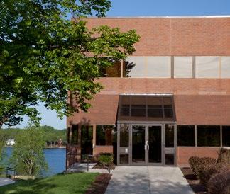


11 Building Pictures

12 ABOUT CSM CSM Corporation began modestly when 12-year-old Gary Holmes, now CSM s CEO, started selling light bulbs door to door in Minneapolis. A young entrepreneur, Gary enlisted his Boy Scout troop as a sales force. At age 14, he used his light bulb earnings to buy his first real estate asset - a set of Minneapolis duplexes. In 1976, Gary s first company, Colonial Apartments became Colonial Services & Management, which later became CSM Corporation. Growth continued, and CSM Corporation began acquiring, developing and renovating residential, commercial and industrial properties across the country. A one million square foot commercial property portfolio grew to more than eight million by 2008 and the residential portfolio increased to over 4,000 units. In 1992, we entered the hotel industry, acquiring and renovating a former Howard Johnson s into a Country Inn by Carlson. Since then, CSM Lodging has acquired, built and managed 37 hotel properties nationwide. CSM Corporation and CSM Lodging expanded significantly over the years to 1,945 employees today.
5101 Shady Oak Road MINNETONKA, MN. Shady Oak Road. Lake Views
 AVAILABILITIES FLOOR S Shady Oak Road Lake Views Welcome to Shady Oak Lake Corporate Center Striking views of Shady Oak Lake and strategically located in the Southwest suburban market, Shady Oak Lake Corporate
Southwest LRT Alignment Video Narration
 Southwest LRT Alignment Video Narration September 2015 Southwest Light Rail Transit, a proposed extension of the METRO Green Line, will serve Minneapolis, St. Louis Park, Hopkins, Minnetonka and Eden Prairie.
Baker/Carver Regional Trail master plan public review draft
 Baker/Carver Regional Trail master plan public review draft November 2014 the mission of Three Rivers Park District is to promote environmental stewardship through recreation and education in a natural
METROPOLITAN COUNCIL 390 North Robert Street, St. Paul, MN Phone (651) TDD (651)
 TDD (651)") METROPOLITAN COUNCIL 390 North Robert Street, St. Paul, MN 55101 Phone (651) 602 1000 TDD (651) 291 0904 DATE: June 19, 2007 TO: Metropolitan Parks and Open Space Commission FROM: Jan Youngquist, Senior
METROPOLITAN COUNCIL 390 North Robert Street, St. Paul, MN 55101 Phone (651) 602 1000 TDD (651) 291 0904 DATE: June 19, 2007 TO: Metropolitan Parks and Open Space Commission FROM: Jan Youngquist, Senior
CHAPTER 1 TRANSIT MARKET AREAS AND EXISTING SERVICE
 CHAPTER 1 TRANSIT MARKET AREAS AND EXISTING SERVICE Transit Market Areas While several factors influence the propensity to use transit, the primary predictors of transit productivity are the density of
Corridor Management Committee Meeting. April 2, 2014
 Corridor Management Committee Meeting April 2, 2014 1 Today s Topics Welcome Approval of Minutes Resolutions Response to March 26 CMC Questions Staff Recommendation on Project Scope and Budget Public Testimony
Design Charrette Public Meeting
 Design Charrette Public Meeting Citizen Advisory Committee Members of the Public November 2, 2011 - Theodore Wirth Chalet - 6:30-8:30 p.m. Park Background: Visitation Estimation 2010 Regional Visitation
Northeast Quadrant Distinctive Features
 NORTHEAST QUADRANT Northeast Quadrant Distinctive Features LAND USE The Northeast Quadrant includes all the area within the planning area that is east of Interstate 5 and to the north of State Route 44.
Discovering the Trails of Prince George s County
 Discovering the Trails of Prince George s County Happy Trails! Since 2005, Wegmans has been partnering with town and city recreation programs and park conservancy groups to encourage folks to get moving
The Baker/Carver Regional Trail is intended to
 Section V Design Guidance The Baker/Carver Regional Trail is intended to safely accommodate 183,000 annual visits, an array of non-motorized uses, a variety of skill levels, and persons with special needs.
INTERNATIONAL PLAZA 7900 INTERNATIONAL DRIVE BLOOMINGTON, MN
 INTERNATIONAL PLAZA 7900 INTERNATIONAL DRIVE BLOOMINGTON, MN 7900 INTERNATIONAL DRIVE, BLOOMINGTON, MN 55425 LOCATION Strategically located in the heart of the Airport West submarket, at the interchange
Blue River Trail Master Plan JSA to Town Hall June 2004
 Blue River Trail Master Plan JSA to Town Hall June 2004 Prepared for: Silverthorne Town Council Silverthorne SPORT Committee Department of Recreation and Culture Silverthorne Public Works Silverthorne
2. Goals and Policies. The following are the adopted Parks and Trails Goals for Stillwater Township:
 D. PARKS AND TRAILS 1. Introduction Stillwater Township s population is relatively low, with most residents living on rural residences on large lots. The need for active park space has been minimal in
Stephens State Park Trails
 TRAILS OF ALLAMUCHY MOUNTAIN & STEPHENS STATE PARKS Allamuchy Mountain and Stephens State Parks contain 28 marked trails providing access to diverse landscapes for walking, hiking, biking, bird-watching,
FEASIBILITY CRITERIA
 This chapter describes the methodology and criteria used to evaluate the feasibility of developing trails throughout the study areas. Land availability, habitat sensitivity, roadway crossings and on-street
Welcome to the future of Terwillegar Park a Unique Natural Park
 Welcome to the future of Terwillegar Park a Unique Natural Park 1 Introduction The Terwillegar Park Concept Plan study will develop an overall concept plan, management objectives and development guidelines
Citrus Heights Creek Corridor Trail Project Trail Advisory Group Field Trip #2 September 11, :00 11:00 am Trellis Hall, Citrus Heights
 September 11, 2013 9:00 11:00 am Trellis Hall, Citrus Heights Project Overview The City of Citrus Heights is studying the feasibility of establishing a multi use trail system within the City s 26 miles
Webinar Series for Comprehensive Plan Updates. Making Your Plan a Walk in the Park
 Webinar Series for Comprehensive Plan Updates Making Your Plan a Walk in the Park Presented by Jan Youngquist and Michael Peterka September 15, 2016 Today s Presentation Importance of Parks and Trails
Business Item No
 Metropolitan Parks and Open Space Commission Meeting date: February 6, 2018 For the Community Development Committee meeting of February 20, 2018 For the Metropolitan Council meeting of February 28, 2018
MPRB: Southwest LRT Community Advisory Committee Issues and Outcomes by Location Current to: 12 November 2010
 MPRB: Southwest LRT Community Advisory Committee Issues and Outcomes by Location Current to: 12 November 2010 This is a compilation of issues and outcomes identified by the CAC. It is a work in progress,
MORGAN CREEK GREENWAY Final Report APPENDICES
 APPENDICES MORGAN CREEK GREENWAY Appendix A Photos of Existing Conditions in Trail Corridor Photos of existing conditions Main trail corridor - February 2009 Photos of existing conditions south bank Morgan
Business Item No xx
 Business Item No. 2015-xx Metropolitan Parks and Open Space Commission Meeting date: April 7, 2015 For the Community Development Committee meeting of April 21, 2015 For the Metropolitan Council meeting
Community Development Committee
 C Community Development Committee For the Metropolitan Council meeting of October 31, 2012 Committee Report Item:2012-316 ADVISORY INFORMATION October 16, 2012 Date Prepared: Subject: Intercity Regional
Becker County Trail Routing Feasibility Study
 2016 Becker County Trail Routing Feasibility Study CONNECTING DETROIT MOUNTAIN AND MOUNTAIN VIEW RECREATIONAL AREA TO THE HEARTLAND TRAIL BECKER COUNTY ULTEIG ENGINEERS Contents Acknowledgements...2 INTRODUCTION...3
Section II. Planning & Public Process Planning for the Baker/Carver Regional Trail began in 2010 as a City of Minnetrista initiative.
 Section II Planning & Public Process Planning for the began in 2010 as a City of initiative. city staff began discussions with the Park District on the possibility of a north/south regional trail connection
PIONEER PARK. City of Des Peres Parks Master Plan. SWT Design 46 INTRODUCTION
 PIONEER PARK INTRODUCTION Pioneer Park is a 7 acre neighborhood park located east of Interstate 270 and south of Manchester Road along Tallie Road. The park is situated in a residential neighborhood with
CITY OF CHASKA PEDESTRIAN MOVEMENT / TRAILS PLAN FINAL CHAPTER 7 PEDESTRIAN MOVEMENT / TRAILS PLAN. Page 1 of 19, Chapter 7
 FINAL CHAPTER 7 PEDESTRIAN MOVEMENT / TRAILS PLAN Page 1 of 19, Chapter 7 ORDER OF CONTENTS I. INTRODUCTION... 3 II. PURPOSE... 3 III. 2030 COMMUNITY TRAILS SYSTEM PLAN... 4 IV. TRAIL TYPES... 7 A. Regional
CHAPTER ONE LITERATURE REVIEW
 CHAPTER ONE LITERATURE REVIEW LITERATURE REVIEW This chapter summarizes the most recently published community impact studies and articles that relate to multiuse trails. The review focuses on publications
Chapter 6: POLICY AND PROCEDURE RECOMMENDATIONS
 Chapter 6 POLICY AND PROCEDURE RECOMMENDATIONS FOR SRRA Below are seven policy elements that should be considered for adoption by the Southwest Regional Recreation Authority of Virginia: 1. Develop strategies
Frederickson LUAC. Community Plan Update. Parks & Recreation. September 25, 2017
 Frederickson LUAC Community Plan Update Parks & Recreation September 25, 2017 Kimberly Freeman Resource Stewardship Superintendent kimberly.freeman@co.pierce.wa.us 253-798-4261 Joseph Coppo Senior Parks
Appendix 3. Greenway Design Standards. The Whitemarsh Township Greenway Plan
 Appendix 3 Greenway Design Standards This chapter discusses two design standards for the greenway types discussed above. First, trail design standards are presented together with trailhead facilities and
City of Haslett. City of East Lansing. City of East Lansing
 Central Park North (Nancy L. Moore Park) Lake Park North Expansion White Park Expansion #2 White Park Expansion #1 County East East Haslett East East TF87-212 Acquisition $90,000.00 Park. TF08-138 Acquisition
Stephens Rd. Nature Preserve
 Stephens Rd. Nature Preserve History Stephens Road Nature Preserve (SRNP) is a 350-acre nature preserve in Huntersville that comprises nine properties purchased between 1994 and 2008. Parcels included
West Orange Trail. Clean, Green, Fun!
 West Orange Trail Clean, Green, Fun! The West Orange Trail - when completed - will be a 36-mile, multipurpose recreational greenway containing a 14-foot wide paved surface to be enjoyed by walkers, joggers,
National Recreation Trail Update Form
 National Recreation Trail Update Form Introduction Thank you for taking the time to complete this form. Your assistance will help ensure that the National Recreation Trail (NRT) database is complete and
Committee Report. Community Development Committee For the Metropolitan Council meeting of August 12, Business Item No.
 Committee Report Business Item No. 2015-168 Community Development Committee For the Metropolitan Council meeting of August 12, 2015 Subject: Coon Creek Regional Trail Master Plan, Anoka County Proposed
National Recreation Trail Application for Designation
 National Recreation Trail Application for Designation Introduction Thank you for your interest in the National Recreation Trail (NRT) program. Completed NRT application packages must be submitted by December
LEGACY WATERIDGE Wateridge Circle Sorrento Mesa, California HOME
 HOME 61,249 sf office space for lease Recently completed capital improvements include lobby upgrades, market-ready work, landscaping and project signage Sorrento Mesa s premier office campus Unparalleled
Business Item No XXX. Proposed Action That the Metropolitan Council approve the Coon Creek Regional Trail Master Plan.
 Business Item No. 2015-XXX Metropolitan Parks and Open Space Commission Meeting date: July 7, 2015 For the Community Development Committee meeting of July 20, 2015 For the Metropolitan Council meeting
Trail Etiquette. Hours of Operation. Trail Accessibility
 Trail Guide The Elmhurst Park District, with 28 parks and over 460 acres of land, offers nearly six miles of paved or asphalt park trails and maintains an additional 3.6 miles of trails within Elmhurst.
Crescent Ridge I Wayzata Boulevard, Minnetonka, Minnesota STYLE LOCATION AMENITIES
 11100 Wayzata Boulevard, Minnetonka, Minnesota STYLE LOCATION AMENITIES TYLE LOCATION AMENITIES WELCOME TO CRESCENT RIDGE CORPORATE CENTER I Crescent Ridge Corporate Center I combines classic architecture
This Passport: Revised October 20, 2017, EAM # Discovering the Trails of Penfield, NY
 This Passport: Revised October 20, 2017, EAM #161922 Discovering the Trails of Penfield, NY The Town of Penfield is fortunate to have a wide variety of natural resources which make for many unique and
OFFERING MEMORANDUM. Applebee s - Ground Lease Walmart Supercenter Outparcel Warren, MI
 Applebee s - Ground Lease Walmart Supercenter Outparcel Warren, MI Florida Investment Sales Exclusively Retail. Extensive Solutions. JOHN ARTOPE Executive Vice President, Market Leader D 407.902.2621 john.artope@srsre.com
China Creek North Park Upgrades and Glen Pump Station. Park Board Committee Meeting Monday, July 10, 2017
 China Creek North Park Upgrades and Glen Pump Station Park Board Committee Meeting Monday, July 10, 2017 Purpose The purpose of this presentation is to: Share the results of the public engagement processes;
Criteria Based System for MPRB Regional Park and Trail Capital Project Scheduling
 Criteria Based System for MPRB Regional Park and Trail Capital Project Scheduling July 19, 2017 Background Beginning with the 2017-2022 Capital Improvement Program (CIP), MPRB used equity-driven metrics
Segment 2: La Crescent to Miller s Corner
 goal of the USFWS refuges is to conserve, protect and enhance fish, wildlife and plants and their habitats for the continuing benefit of the American people. Refuge lands are used largely for fishing,
South Fork/Greenway Center Trail, City of Middleton, WI
 South Fork/Greenway Center Trail, City of Middleton, WI Middleton, Wisconsin welcomes trail users of all abilities to continue their trek from the highly praised Pheasant Branch Conservancy Trail, through
Southwest Quadrant Distinctive Features
 SOUTHWEST QUADRANT Southwest Quadrant Distinctive Features LAND USE The 31.17 square mile Southwest Quadrant includes all the area within the planning area west of I-5 and south of the Sacramento River.
Site Location and Setting
 Memorandum Date: To: From: Subject: Kristy Le, Gary Black Steve Orem Santa Teresa County Park Historic Area Traffic and Parking Study Hexagon Transportation Consultants, Inc. has completed a traffic and
CHAPTER 5. Chapter 5 Recreation Element
 CHAPTER 5 Recreation Element Chapter 5 Recreation Element The Recreation Element of the Meyers Area Plan is a supplement to the Recreation Element of the TRPA Regional Plan and the El Dorado County General
BRACEVILLE NATURE PRESERVE Introductions History Present Conditions Future Development Plans Implementation Strategies Statistics
 BRACEVILLE NATURE PRESERVE Introductions History Present Conditions Future Development Plans Implementation Strategies Statistics Introduction Braceville Nature Preserve is one of MetroParks largest preserves.
17 Mathilda Welmering Park Planning Zone 3
 17 Mathilda Welmering Park Planning Zone 3 8301 Mathilda Visit Date: September 2016 St. Louis County Parks Master Plan Page 1 Description: The six acre Mathilda Welmering Park is named for two streets
Greater Minnesota Regional Parks and Trails Commission Designation Application
 Greater Minnesota Regional Parks and Trails Commission Designation Application General Section Designation Application #: 15-059D Date Submitted: 06/16/2015 Park or Trail Name: Mesabi Trail District #:
Understanding user expectations And planning for long term sustainability 1
 Understanding user expectations And planning for long term sustainability 1 What is a natural surface trail? It can be as simple has a mineral soil, mulched or graveled pathway, or as developed as elevated
2009 Regional Solicitation Selected Projects*
 2009 Regional Solicitation Selected Projects* Special Federal Allocation from the MPO Mn/DOT I-494/TH169 Interchange Reconstruction $34,000,000 Surface Transportation Program - Urban Guarantee AR-09-10
WATERIDGE POINTE WATERIDGE CIRCLE SORRENTO MESA, CALIFORNIA
 10421-10431 WATERIDGE CIRCLE SORRENTO MESA, CALIFORNIA 20,120 sf office space for lease; divisible Sorrento Mesa s premier office campus Unparalleled views and superb freeway access Freestanding, Class
Dungeness Recreation Area County Park Master Plan
 Dungeness Recreation Area County Park Public Outreach Meeting October 10, 2007 Project Overview USFWS Site Dungeness Recreation Area County Park Meeting Objectives: Re-Introduce project; provide status
Meeting Summary. 1. Welcome and Review of Meeting Summary
 Southwest Light Rail Transitway (SWLRT) Community Advisory Committee Meeting January 26, 2016 Southwest Project Office 6465 Wayzata Blvd, Suite 500 St. Louis Park, MN 55426 6:00 PM 8:00 PM Meeting Summary
DOWNTOWN EAST RESTAURANT AND RETAIL SPACE. Matt Friday. Senior Vice President
 DOWNTOWN EAST RESTAURANT AND RETAIL SPACE AVAILABLE for lease Matt Friday Senior Vice President 612 336 4209 matt.friday@cbre.com David Daly Vice President 612 336 4319 david.daly@cbre.com Eric Sheaffer
United States Department of the Interior National Park Service. Boundary Expansion Listed in National Register January 11, 2017
 NPS Form 10900-a (Rev. 8/2002) OMB No. 10240018 United States Department of the Interior National Park Service Boundary Expansion Listed in National Register January 11, 2017 National Register of Historic
Meshach Browning Trail System at the Deep Creek Lake Lion s Club Park on Bumble Bee Rd.
 Meshach Browning Trail System at the Deep Creek Lake Lion s Club Park on Bumble Bee Rd. The Meshach Browning trail system will be a public, non-motorized, multi-use (running, dog-walking, cross country
Crystal Lake Area Trails
 Lake Area Trails Welcome to the Lake area of the Big Snowy Mountains! This island mountain range in central Montana features peaks reaching to 8,600 feet and long, high ridges from which vistas of the
Greater Minnesota Regional Parks and Trails Commission Designation Application
 Greater Minnesota Regional Parks and Trails Commission Designation Application General Section Designation Application #: 15-050D Date Submitted: 06/30/2015 Park or Trail Name: Perham to Pelican Rapids
PARK PAVILION RULES AND REGULATIONS
 1 HARRY S. TRUMAN PARKWAY ANNAPOLIS, MARYLAND 21401 410-222-7300 PARK PAVILION RULES AND REGULATIONS Reservation Permit Is Issued Subject To The Following: 1. This permit is for a maximum of 100 persons
Park Place At Nocatee. Ponte Vedra, FL. Leasing Now! Park Place One - 125,000 SF Class A Office Building on Nocatee Parkway
 Park Place At Nocatee Ponte Vedra, FL Leasing Now! Park Place One - 125,000 SF Class A Office Building on Nocatee Parkway PARK PLACE AT NOCATEE PROPERTY OVERVIEW THE MARKET PROJECT SIZE 675,000 SF ANTICIPATED
Hiawatha National Forest St. Ignace Ranger District. File Code: 1950 Date: August 5, 2011
 United States Department of Agriculture Forest Service Hiawatha National Forest St. Ignace Ranger District W1900 West US-2 St. Ignace, MI 49781 906-643-7900 File Code: 1950 Date: August 5, 2011 Dear National
ADA Compliance Projects Summary Sheet
 District Letter Dated Project % to ADA Amount Granted Buffalo Grove March 10, 2014 Woodland Park - asphalt path 100% $4,500.00 Buffalo Grove March 10, 2014 Wellington Commons Bike path repairs including:
Chapter 9 Recreation
 Chapter 9 Chapter 9 1.0 INTRODUCTION The Town of Littleton is within one of New England s most important recreation areas. More than three million people live within 100 miles of the area. Local residents
Gardner: overview. Santa Fe, Oregon, and California National Historic Trails UNINCORPORATED JOHNSON COUNTY OLATHE UNINCORPORATED JOHNSON COUNTY
 Santa Fe, Oregon, and California ational Historic Trails : overview 99: p.134 100: p.135 GARDER JUCTIO 102: p.137 56: p.126 EDGERTO Burlington orthern Intermodal and Logistics 98: p.133 101: p.136 S Waverly
Aspen Skiing Company Policy for Use of Other Power-Driven Mobility Devices And Service Animals
 Aspen Skiing Company Policy for Use of Other Power-Driven Mobility Devices And Service Animals Introduction New rules under the Americans with Disabilities Act (ADA), Titles II and III, went into effect
Active Living Partners. Trails. Hennepin County. Bloomington. Brooklyn Park. Crystal. Excelsior. Golden Valley. Hopkins. Independence.
 d rove app Active Living Partners When using the do. seal of approval in publications, include service mark notice: do. is a registered mark of Blue Cross and Blue Shield of Minnesota, a nonprofit independent
Lake Myra County Park. Wake County, North Carolina Community Forum #2 June 12, 2008
 Lake Myra County Park Wake County, North Carolina Community Forum #2 June 12, 2008 Welcome and Introduction Meeting Agenda Welcome Introductions of Project Team Master Plan Process Community Forum #1 Updates
Non-Motorized Transportation
 Non-Motorized Transportation Non-motorized facilities are important components to the transportation system. They provide an environmentally-friendly, low-cost mode of travel. Some of the facilities can
EXECUTIVE SUMMARY FALL Introduction. Findings
 EXECUTIVE SUMMARY FALL 2004 Introduction Trails are one of the most popular and highly desirable recreational resources in communities of all sizes throughout the country. In addition to providing a safe
THE ENERGY OF AUSTIN.
 A 25 ACRE MIXED-USE DEVELOPMENT THE ENERGY OF AUSTIN. THE LIFE ON THE LAKE. OPEN 2014 The Arboretum The Domain 2nd Street District Southpark Meadows Cypress South Shore Pointe Site The Waterfront Amli
1500 Centre Parkway, East Point, GA. Up to 97,969 SQ FT corporate office user opportunity in Airport submarket
 Up to 97,969 SQ FT corporate office user opportunity in Airport submarket BEST IN CLASS QUALITY MEETS OUTSTANDING FLEXIBILITY Camp Creek 1500 is a Class A, two-story office building that s ideal for a
Georgetown-Lewes Rail/Trail Study. Rail/Trail Study: Cool Spring to Cape Henlopen State Park New Road Extension (House Resolution No.
 Georgetown-Lewes Rail/Trail Study Rail/Trail Study: Cool Spring to Cape Henlopen State Park New Road Extension (House Resolution No. 47) August 22, 2011 Presentation Outline Background Benefits Statewide
Procedure for the Use of Power-Driven Mobility Devices on Mass Audubon Sanctuaries 1 September 17, 2012
 Procedure for the Use of Power-Driven Mobility Devices on Mass Audubon Sanctuaries 1 September 17, 2012 Background As part of Mass Audubon s mission to preserve the nature of Massachusetts for people and
1,600-3,200 SF As-Built Suites Now Available THREE HUGHES LANDING THE WOODLANDS, TEXAS
 1,600-3,200 SF As-Built Suites Now Available THREE HUGHES LANDING THE WOODLANDS, TEXAS Three Hughes Landing Situated in Hughes Landing, Three Hughes Landing is within walking distance to many amenities
Sacramento Placerville Transportation Corridor Alternatives Analysis
 Sacramento Placerville Transportation Corridor Alternatives Analysis EL DORADO COUNTY TRANSPORTATION COMMISSION 1 Sacramento Placerville Transportation Corridor 2 Goal of the Project To give public officials
WATER PETALUMA TRAIL WATER WAYS PROJECT PORTFOLIO. petalumawaterways.org OVERVIEW
 WATER TRAIL PROJECT PORTFOLIO OVERVIEW Thirteen miles upstream of San Pablo Bay, Petaluma is the northern point on the San Francisco Bay Water Trail, a network of access points throughout the region. Most
4.0 Context for the Crossing Project
 4.0 Context for the Crossing Project This section provides background information about key features of the North Douglas Crossing project area, and opportunities and constraints. This information is important
Trail Feasibility Study
 VOLUSIA COUNTY MPO CITY OF NEW SMYRNA BEACH FINAL REPORT JUNE 30, 2009 Trail Feasibility Study What s inside? 1 Introduction 2 Project Purpose & Scope 3 Physical Inventory & Assessment of Right-of- Way
Jefferson County Non-Motorized Transportation and Recreational Trails Plan 2010
 Chapter 8: Goals and objectives Plan Update: The following update presents general principles, goals, and objectives related to non-motorized transportation facilities as a component of the overall transportation
Winnebago County Community Park
 Directions to Community Park From Interstate Hwy. 41 to Oshkosh exit 124, which is Hwy. 76/Jackson Street. East on Hwy 76/ Jackson Street to left on County Road Y, 1/4 mile. Winnebago County Park is on
Beth Lucas, Senior Planner Stephanie Brewer, Planner Broome County Planning May 12 th, 2016
 Beth Lucas, Senior Planner Stephanie Brewer, Planner Broome County Planning May 12 th, 2016 Background Data Collection Trail Mapping Promotional Strategy December 2014 County s natural beauty identified
COMMUNITY PROFILE Uptown, Minneapolis
 COMMUNITY PROFILE Uptown, Minneapolis 394 HENNEPIN AVE LYNDALE AVE 94 Uptown DOWNTOWN MINNEAPOLIS 35W W. LAKE STREET 35W 94 Uptown is a vibrant commercial and residential district located two miles southwest
Blueways: Rivers, lakes, or streams with public access for recreation that includes fishing, nature observation, and opportunities for boating.
 Parks, Open Space and Trails PRINCE WILLIAM COUNTY 2008 COMPREHENSIVE PLAN TRAILS PLAN CONTENTS The components of the trails plan are: Intent Definitions Goals, Policies, and Action Strategies Trails Map
Summary of Public Comments and Preliminary Cost Estimate January 30, 2014 (Updated February 20, 2014)
") Proposed Regional Trail Carver to Baker Park Reserves Summary of Public Comments and Preliminary Cost Estimate January 30, 2014 (Updated February 20, 2014) The Park District is working on the development
Proposed Regional Trail Carver to Baker Park Reserves Summary of Public Comments and Preliminary Cost Estimate January 30, 2014 (Updated February 20, 2014) The Park District is working on the development
MASTER PLAN EXECUTIVE SUMMARY
 Biscuit Run State Park Scottsville Road (State Route 20) Charlottesville, VA 22902 Biscuit Run State Park MASTER PLAN EXECUTIVE SUMMARY Department of Conservation and Recreation Division of Planning and
Trail # NW Tuesday, June DESIGN. Provide an Review the Provide an. Project Goals: System system. wayfinding
 I. Welcome / Introductions Bethany Creek Trail #2 Segment 3 Neighborhood Meeting #1 Bethany Presbyterian Church 15505 NW Springville Road, Portland, OR 97229 Tuesday, June 26, 2018 @ 6:00PM Meeting Minutes
Extending TRACKS. Design and engineering effort nears completion. Animation shows how light rail will operate in Hopkins
 February 2017 Issue 16 www.swlrt.org Extending TRACKS Design and engineering effort nears completion The Southwest LRT Project has finalized its civil design and is finalizing systems and Operations and
Beaverhead-Deerlodge National Forest Butte Ranger District
 United States Department of Agriculture Forest Service Beaverhead-Deerlodge National Forest 1820 Meadowlark Lane Butte, MT 59701 406 494-2147 File Code: 1950 Date: September 1, 2010 Dear Interested Party:
FOR LEASE PRIME CBD COMMERCIAL SPACE. 169 : 19,284 SF on Three Levels 175 : 14,000 SF on Two Levels
 PRIME CBD COMMERCIAL SPACE FOR LEASE 169 + 175 Rosa L. Parks Boulevard, Nashville, TN 37203 169 : 19,284 SF on Three Levels 175 : 14,000 SF on Two Levels COLLIERS INTERNATIONAL 523 3rd Avenue South, Nashville,
DRAFT - APRIL 13, 2007 ROUTING STUDY FOR TRAIL CONNECTIONS BETWEEN CALAIS AND AYERS JUNCTION
 DRAFT - APRIL 13, 2007 ROUTING STUDY FOR TRAIL CONNECTIONS BETWEEN CALAIS AND AYERS JUNCTION Abstract The vision for the East Coast Greenway is an off-road urban trail system running from Calais, Maine
Public Park System. Township of Derry. Providing natural open space for the recreational use of our residents and guests.
 Township of Derry Public Park System Providing natural open space for the recreational use of our residents and guests. Directory of Recreational Amenities Hershey s Commitment to Recreation Famous candy
ANCLOTE COASTAL TRAIL ALTERNATIVES ANALYSIS STUDY
 ANCLOTE COASTAL TRAIL ALTERNATIVES ANALYSIS STUDY PASCO COUNTY MPO JULY 2015 PROJECT OVERVIEW... INTRODUCTION EXECUTIVE SUMMARY CONTEXT... TAMPA BAY AREA, PINELLAS, & PASCO COUNTY S MULTI-USE TRAIL PLANS
CHAPTER FIVE PROSPECTS FOR FUTURE ECONOMIC DEVELOPMENT
 CHAPTER FIVE PROSPECTS FOR FUTURE ECONOMIC DEVELOPMENT 5.1 GENERAL The recommended type and location of future land uses in Alpine should, in part, consider potential opportunities for future economic
For Lease Retail Space LUXURY
 1127 LUXURY Euclid Avenue,Cleveland, Ohio 44115 RYAN FISHER Vice President Retail Services DIRECT 216 239 5069 ryan.fisher@colliers.com > PROPERTY HIGHLIGHTS Excellent opportunity to locate at the center
Where Business and Nature thrives
 Where Business and Nature thrives WHERE BUSINESS AND NATURE THRIVES Situated on a picturesque 43-acre forested hillside in the center of Tulsa, Warren Place offers an ideal location, incomparable amenities,