Beaverhead-Deerlodge National Forest Butte Ranger District
|
|
|
- Melanie Richard
- 5 years ago
- Views:
Transcription
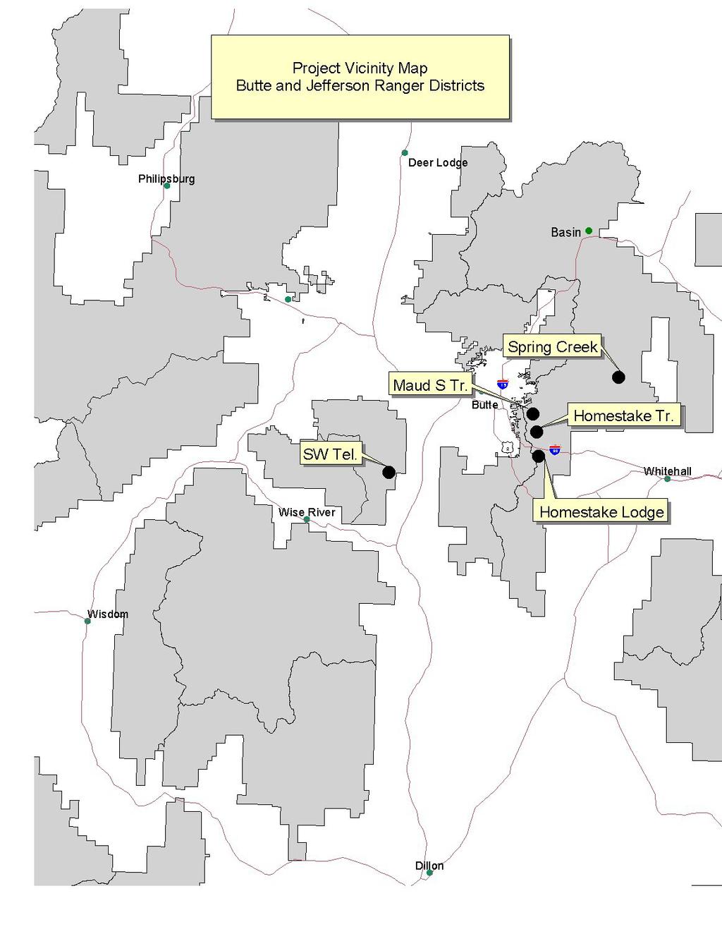
1 United States Department of Agriculture Forest Service Beaverhead-Deerlodge National Forest 1820 Meadowlark Lane Butte, MT File Code: 1950 Date: September 1, 2010 Dear Interested Party: The Butte and Jefferson Ranger Districts of the Beaverhead-Deerlodge National Forest are proposing several projects. The following is the background information on the projects, a description of the Purpose and Need, and the Proposed Action. Maud S Canyon Trail #4815 Relocation T 2 N, R 7 W. sec. 27 and 34 This proposal would relocate and construct approximately 2 miles of Maud S Trail #815 to connect with the Continental Divide National Scenic Trail (CDNST). The trail is located east of I-90 at the Continental Drive Interchange and extends from the Maud S Canyon Trailhead east to the top of the continental divide where it meets with the newly constructed CDNST. The existing trail is a primitive trail that is steep with several areas that are highly eroded and has two unprotected stream crossings. The trail would be reconstructed to meet Forest Service design standards for non-motorized uses (foot, horse, and mountain bicycle). Motorized use would not be allowed. The existing 1.5 mile trail would be obliterated with this project. Southwest Montana Telephone T. 1 N., R. 9 W., Sec. 4, 5, 8, and 9 T 2 N., R 9 W., sec. 33 and 34 Southwest Montana Telephone proposes to bury fiber optic cable on the. Approximately 5.18 miles of fiber optic cable would be buried within current road and telephone rights-of-ways along FS road nos. 96, 447, and The cable would be installed with a static plow that lays the cable at the same time the trench is dug. The line would be buried parallel to the existing line. Above ground pedestals (splice points) will be installed approximately every.85 miles. The old pedestals would remain in place to provide battery backup for the system. SW Montana Telephone has an existing special use authorization for telephone lines. Caring for the Land and Serving People Printed on Recycled Paper
2 Jefferson Ranger District Homestake Trail #7071 Relocation T2N, R6W; sections 13 and 17/20 The Forest Service is proposing to relocate two segments of Homestake Trail No in the Whitetail-Pipestone area. The trail begins at Homestake Trailhead and continues to the Four Corners Trailhead north of the Pipestone exit on Interstate 90. This project will address public safety issues associated with the Burlington Northern Santé Fe RR (BNSF) and Homestake Trail #7071. Currently the two segments are located on the railroad bed which that were identified as a safety concern to BNSF as a result of a review of the trails with Forest Service and BNSF personnel. The first segment is located approximately 500 feet east of the Homestake Trailhead that would cross at the same location, but would cross both sets of tracks and continue for approximately 500 feet. A new trail approximately 500 feet long would be constructed. It would include construction of a raised puncheon bridge (6 feet wide) approximately 200 feet long to protect a wet meadow area. Curbing would be installed on the puncheon to keep trail users from going off the puncheon bridge. The second segment is located 1.6 miles east of Homestake Trailhead. The proposal is to relocate and construct a new trail approximately 1,300 feet long to avoid use of the railroad. It would include construction of a raised puncheon bridge (6 feet wide) approximately 200 feet long to protect a wet meadow area. Curbing would be installed on the puncheon to keep trail users from going off the puncheon bridge. The new trail segments would be constructed to a motorized trail standard of 48 inches; which is the Forest Service design standards for motorized trails. Approximately 1,900 feet of existing trail routes would be blocked and/or obliterated to keep the public from using the trails. The trail projects are not located within an inventoried roadless area. The reasons we determined the project does not require notice, comment and appeal are that first, the project would not designate a new travel route for OHVs. The Homestake Trail and adjacent trails in the area currently allow OHV uses as identified on the 2009 Beaverhead-Deerlodge National Forest Plan and Beaverhead-Deerlodge Forest Visitor Map. No new designation for OHV use is being proposed with this project. Second, the project does not construct new OHV routes or facilities. It would relocate existing OHV routes to address safety concerns associated with the BNSF railroad. The abandoned segments would be closed to the public as they are located on BNSF property. Third, the project would not increase the levels or types of OHV use. Use levels and types would likely remain the same as the trail is currently open and in use because the new section merely replaces, not improves the OHV recreation opportunity. The relocated trails will continue to accommodate similar ATV and motorcycle uses.
3 Spring Creek Trail #7093 Relocation T3N, R5W; sections 10 and 15 The Forest Service is proposing to relocate approximately 2,500 feet of Spring Creek Trail no to move the trail off private land. Spring Creek Trail is open to motorized ATV and motorcycle uses. Approximately 2,300 feet of new trail would be constructed to a motorized trail standard of 48 inches; which is the Forest Service design standards for motorized trails. The trail project is not located within an inventoried roadless area. The reasons we determined the project does not require notice, comment and appeal are that first, the project would not designate a new travel route for OHVs. The Spring Creek Trail and adjacent trails currently allow OHV uses as identified on the 2009 Beaverhead-Deerlodge National Forest Plan and Beaverhead-Deerlodge Forest Visitor Map. No new designation for OHV use is being proposed with this project. Second, the project does not construct new OHV routes or facilities. It would relocate an existing OHV route to address private land issues. The abandoned segment would be closed to the public as it located on private land. Third, the project would not increase the levels or types of OHV use. Use levels and types would likely remain the same as the trail is currently open and in use because the new section merely replaces, not improves the OHV recreation opportunity. The relocated trail will continue to accommodate similar ATV and motorcycle uses. Homestake Lodge Cross Country Ski Trails Permit Amendment T. 2 N., R. 6 W., Sec. 19, 20, 29, and 30 A proposal from Homestake Lodge to amend their special use authorization to maintain and groom approximately 3.23 miles of cross country ski trails using a 10-foot wide groomer. The authorization would also permit certain cross-country skiing events consistent with approved operating plans. The proposal would create loop opportunities connecting with trails located on private lands owned by Homestake Lodge to provide for a type of skiing experience and trip distance commonly desired by cross-country skiers. The trail routes consist of unclassified routes and open areas. The permitted use would include non-motorized (foot and mountain bike) summer use on existing routes only. Signs and barriers are used in the winter to discourage motorized use on the trails. Comments Please share your comments, concerns, or ideas with us by Friday September 17, 2010 by hardcopy, phone, fax, or electronically. The Butte District Ranger is the deciding official.
4 Any Questions or Comments You can send comments to: Janet L.Krivacek District Ranger 1820 Meadowlark Butte, MT Fax: If you wish to receive information on the decision for this proposal you must respond to this scoping notice. For additional information please contact Jocelyn Dodge at (406) or To be removed from this mailing list call (406) or /S/ JANET L KRIVACEK 9/1/2010 JANET L. KRIVACEK District Ranger DATE
5
DECISION MEMO. Rawhide Trail #7073 Maintenance and Reconstruction
 Page 1 of 6 Background DECISION MEMO USDA Forest Service Jefferson Ranger District Jefferson County, Montana Rawhide Trail #7073 is located in the Elkhorn Mountain Range approximately 10 miles east of
DECISION MEMO Whetstone Ridge Trail #8020 Relocation
 Page 1 of 7 Background DECISION MEMO Whetstone Ridge Trail #8020 Relocation USDA Forest Service Pintler Ranger District Granite County T4N, R16W, Sections 4,9,29 and T4N, R17W, Section 36 Whetstone Ridge
Hiawatha National Forest St. Ignace Ranger District. File Code: 1950 Date: August 5, 2011
 United States Department of Agriculture Forest Service Hiawatha National Forest St. Ignace Ranger District W1900 West US-2 St. Ignace, MI 49781 906-643-7900 File Code: 1950 Date: August 5, 2011 Dear National
Kelly Motorized Trails Project Proposed Action
 Kelly Motorized Trails Project Proposed Action November 28, 2011 The Flagstaff Ranger District of the Coconino National Forest is seeking public input on the proposed Kelly Motorized Trails Project (formerly
Francis Marion and Sumter National Forests
 United States Department of Agriculture Forest Service Francis Marion and Sumter National Forests 2967 Steed Creek Rd. Huger, SC 29450 Tele: (843)336-2200 File Code: 1950 Date: February 13, 2015 To Whom
September 14, Comments of the Colorado Trail Foundation On the USFS Scoping Notice of August 13, 2010 RE: the relocation of the CDNST/CT Page 1
 THE COLORADO TRAIL FOUNDATION Comments on the U.S. Forest Service Scoping Notice of August 13, 2010 Regarding the Relocation of THE COLORADO TRAIL AND CONTINENTAL DIVIDE NATIONAL SCENIC TRAIL From La Garita
PROPOSED ACTION South 3000 East Salt Lake City, UT United States Department of Agriculture
 United States Department of Agriculture Forest Service Uinta-Wasatch-Cache National Forest Salt Lake Ranger District 6944 South 3000 East Salt Lake City, UT 84121 801-733-2660 File Code: 1950/2300 Date:
Table of Contents. page 3 Long term Goals Project Scope Project History. 4 User Groups Defined Trail Representative Committee. 5 Trail Users Breakdown
 Launched April 27th, 2010 1 Table of Contents page 3 Long term Goals Project Scope Project History 4 User Groups Defined Trail Representative Committee 5 Trail Users Breakdown 13 Trail Users Desires 16
Proposed Project 1: Kimble Loop East Horse Trail Reroute (1). Horse Trail Reroute: March 14, 2012
. Horse Trail Reroute: March 14, 2012") Proposed Project 1: Kimble Loop East Horse Trail Reroute The Ironton District Ranger requests your comments on proposed trail project on National Forest System lands. (1). Horse Trail Reroute: The proposed
Proposed Project 1: Kimble Loop East Horse Trail Reroute The Ironton District Ranger requests your comments on proposed trail project on National Forest System lands. (1). Horse Trail Reroute: The proposed
Decision Memo Ice Age Trail Improvement (CRAC 37)
") Decision Memo Ice Age Trail Improvement (CRAC 37) U.S. Forest Service Chequamegon-Nicolet National Forest, Medford-Park Falls Ranger District Taylor County, Wisconsin T32N, R2W, Town of Grover, Section
Decision Memo Ice Age Trail Improvement (CRAC 37) U.S. Forest Service Chequamegon-Nicolet National Forest, Medford-Park Falls Ranger District Taylor County, Wisconsin T32N, R2W, Town of Grover, Section
White Mountain National Forest. Pond of Safety Accessible Trail & Shoreline Access Project. Scoping Report. Township of Randolph Coos County, NH
 White Mountain National Forest United States Department of Agriculture Forest Service Eastern Region Pond of Safety Accessible Trail & Shoreline Access Project Township of Randolph Coos County, NH Scoping
Tracy Ridge Shared Use Trails and Plan Amendment Project
 Tracy Ridge Shared Use Trails and Plan Amendment Project Scoping Document Forest Service Allegheny National Forest Bradford Ranger District McKean, County, Pennsylvania In accordance with Federal civil
Colorado s forests are slated to lose thousands of miles of roads through the new OHV Route Designation process. DON T LET IT HAPPEN!
 Colorado s forests are slated to lose thousands of miles of roads through the new OHV Route Designation process. DON T LET IT HAPPEN! This packet identifies many roads that you may lose if you don t act.
Paiute Trail Hatfield-McCoy Highwood Mountains
 Paiute Trail Hatfield-McCoy Highwood Mountains Located in Central Utah Main trail is 238 miles 550 miles of designated side trails Links 16 communities in 4 counties Ranges from 5,200 to 11,500 feet Great
Hermosa Area Preservation The Colorado Trail Foundation 4/11/2008
 Hermosa Area Preservation The Colorado Trail Foundation 4/11/2008 Legend d o Tr ail NPA - National Protection Area ra NCA - National Conservation Area o e C Th The Colorado Trail lo FS inventoried Roadless
March 14, SUBJECT: Public input to the Bureau of Land Management, Gunnison Field Office, Travel Management Plan
 March 14, 2019 Delivered via email to ewaters@blm.gov Elijah Waters Field Manager BLM Gunnison Field Office Gunnison, CO 81230 SUBJECT: Public input to the Bureau of Land Management, Gunnison Field Office,
White Mountain National Forest Saco Ranger District
 United States Department of Agriculture Forest Service White Mountain National Forest 33 Kancamagus Highway Conway, NH 03818 Comm: (603) 447-5448 TTY: (603) 447-3121 File Code: 1950 Date: February 26,
Daisy Dean Trail 628/619 ATV Trail Construction
 Background and Purpose and Need The Daisy Dean ATV Trail Construction Project is located in the Little Belt Mountains, Musselshell Ranger District, Lewis and Clark National Forest approximately 32 miles
White Mountain National Forest
 White Mountain National Forest United States Department of Agriculture Forest Service Eastern Region Boles Brook Snowmobile Bridge Decision Memo Boles Brook Snowmobile Bridge Project Town of Woodstock
Steer Creek Campground Corral
 Steer Creek Campground Corral Purpose and Need The purpose of this project is to increase the availability of camping experiences and services for equestrians at the Steer Creek Campground in the Samuel
Bradley Brook Relocation Project. Scoping Notice. Saco Ranger District. United States Department of Agriculture Forest Service
 Bradley Brook Relocation Project United States Department of Agriculture Forest Service Scoping Notice White Mountain National Forest February 2011 For Information Contact: Jenny Burnett White Mountain
FOREST SERVICE MANUAL NATIONAL HEADQUARTERS (WO) WASHINGTON, DC
 WASHINGTON, DC") Page 1 of 77 FOREST SERVICE MANUAL NATIONAL HEADQUARTERS (WO) WASHINGTON, DC FSM 2300 RECREATION, WILDERNESS, AND RELATED RESOURCE MANAGEMENT CHAPTER TRAIL, RIVER, AND SIMILAR RECREATION OPPORTUNITIES
Page 1 of 77 FOREST SERVICE MANUAL NATIONAL HEADQUARTERS (WO) WASHINGTON, DC FSM 2300 RECREATION, WILDERNESS, AND RELATED RESOURCE MANAGEMENT CHAPTER TRAIL, RIVER, AND SIMILAR RECREATION OPPORTUNITIES
As required by 36 C.F.R (d), objectors provide the following information:
, objectors provide the following information:") May 12, 2014 Objection Reviewing Officer USDA Forest Service, Northern Region P.O. Box 7669 Missoula, MT 59807 Dear Objection Reviewing Officer: This letter serves as The Wilderness Society s ( TWS ) objection
May 12, 2014 Objection Reviewing Officer USDA Forest Service, Northern Region P.O. Box 7669 Missoula, MT 59807 Dear Objection Reviewing Officer: This letter serves as The Wilderness Society s ( TWS ) objection
National Recreation Trail Application for Designation
 National Recreation Trail Application for Designation Introduction Thank you for your interest in the National Recreation Trail (NRT) program. Completed NRT application packages must be submitted by December
Non-motorized Trail Plan & Proposal. August 8, 2014
 Town of Star Valley Ranch, Wyoming and the Star Valley Ranch Association in partnership with the USDA Forest Service, Bridger-Teton National Forest, Greys River Ranger District Non-motorized Trail Plan
National Recreation Trail Update Form
 National Recreation Trail Update Form Introduction Thank you for taking the time to complete this form. Your assistance will help ensure that the National Recreation Trail (NRT) database is complete and
RECREATION. Seven issues were identified that pertain to the effects of travel management on outdoor recreation within portions of the project area.
 RECREATION Seven issues were identified that pertain to the effects of travel management on outdoor recreation within portions of the project area. OPPORTUNITIES FOR SOLITUDE / QUIET TRAILS. One attraction
White Mountain National Forest Saco Ranger District
 United States Department of Agriculture Forest Service White Mountain National Forest Saco Ranger District 33 Kancamagus Highway Conway, NH 03818 Comm: (603) 447-5448 TTY: (603) 447-3121 File Code: 1950
RIM TRAIL EXTENSION PROJECT
 DECISION MEMO For RAINBOW RIM TRAIL EXTENSION PROJECT Located on National Forest System Lands USDA Forest Service, Southwest Region Kaibab National Forest - North Kaibab Ranger District T.35 N, R.1 E,
TAYLOR CANYON RANCH COLORADO - ROUTT COUNTY - STEAMBOAT SPRINGS
 TAYLOR CANYON RANCH COLORADO - ROUTT COUNTY - STEAMBOAT SPRINGS Tucked up against the steep valley shaped by Mt. Pau and rising to the Routt National Forest, Taylor Canyon Ranch is an easily accessible,
Decision Memo for Desolation Trail: Mill D to Desolation Lake Trail Relocation
 for Salt Lake County, Utah Uinta-Wasatch-Cache National Forest Salt Lake Ranger District 1. Background The present location of the Desolation Trail (#1159) between Mill D and Desolation Lake follows old
Williamson Rock/Pacific Crest National Scenic Trail (PCT) Project EIS. Notice of intent to prepare an Environmental Impact Statement.
 Project EIS. Notice of intent to prepare an Environmental Impact Statement.") [3411-15-P] DEPARTMENT OF AGRICULTURE Forest Service Angeles National Forest; Los Angeles County, CA Williamson Rock/Pacific Crest National Scenic Trail (PCT) Project EIS AGENCY: ACTION: Forest Service,
[3411-15-P] DEPARTMENT OF AGRICULTURE Forest Service Angeles National Forest; Los Angeles County, CA Williamson Rock/Pacific Crest National Scenic Trail (PCT) Project EIS AGENCY: ACTION: Forest Service,
The Missouri Department of Transportation is proposing to amend the state's five-year Statewide Transportation Improvement Program (STIP).
.") The Missouri Department of Transportation is proposing to amend the state's five-year Statewide Transportation Improvement Program (STIP). A 7-day public comment period regarding the amendment begins January
The Missouri Department of Transportation is proposing to amend the state's five-year Statewide Transportation Improvement Program (STIP). A 7-day public comment period regarding the amendment begins January
Whitefish Range Partnership Tentatively Approved by WRP 11/18/2013!Rec. Wilderness Page 1
 Whitefish Range Partnership Tentatively Approved by WRP 11/18/2013!Rec. Wilderness Page 1 Recommended Wilderness Background The Whitefish Range has a long management and legislative history associated
PURPOSE AND NEED. Introduction
 Public Scoping: Allocation of Recreation Capacity for Commercial Outfitter Guide Services on North Kruzof Island Trails (Kruzof Island Outfitter Guide) PURPOSE AND NEED Introduction The U.S. Department
Proposed Action. Payette National Forest Over-Snow Grooming in Valley, Adams and Idaho Counties. United States Department of Agriculture
 United States Department of Agriculture Forest Service January 2012 Proposed Action Payette National Forest Over-Snow Grooming in Valley, Adams and Idaho Counties Payette National Forest Valley, Adams
S. 37, Forest Jobs and Recreation Act (FJRA)
") Testimony of Jeremy Fancher, International Mountain Bicycling Association Before the U.S. Senate Committee on Energy and Natural Resources Subcommittee on Public Lands, Forests, and Mining Hearing on Misc.
Testimony of Jeremy Fancher, International Mountain Bicycling Association Before the U.S. Senate Committee on Energy and Natural Resources Subcommittee on Public Lands, Forests, and Mining Hearing on Misc.
Wilderness Process #NP-1810: Your letter ID is NP September 5, 2018
 Wilderness Process #NP-1810: Your letter ID is NP-1810-2602-96 September 5, 2018 RE: GMUG Wilderness Evaluation Revised Evaluation Criteria and Draft Report Forest Revision Planning Team: The Continental
Lakeview-Reeder Fuel Reduction Project
 Lakeview-Reeder Fuel Reduction Project Recreation Resource Report Prepared by: Dale Schrempp Recreation Manager Priest Lake Ranger District Report completed: March 25, 2008 Abstract In summary, this report
The Chu property is a 6.57 acre parcel located in the Town of Superior on the west side of McCaslin Boulevard. In 2014, the Town of Superior acquired
 1 The Chu property is a 6.57 acre parcel located in the Town of Superior on the west side of McCaslin Boulevard. In 2014, the Town of Superior acquired the Chu property for open space with a contribution
RE: Objection to Blackfoot Travel Plan Final EIS and two RODS and Alternative 4
 May 11, 2014 Objection Reviewing Officer USDA Forest Service Northern Region PO Box 7669 Missoula MT 59807 VIA EMAIL: appeals-northern-regional-office@fs.fed.us RE: Objection to Blackfoot Travel Plan Final
Mt. Hood National Forest
 United States Department of Agriculture Forest Service Mt. Hood National Forest Zigzag Ranger District 70220 E. Highway 26 Zigzag, OR 97049 503-622-3191 Fax: 503-622-5622 File Code: 1950-1 Date: June 29,
Wild Sky Wilderness Area
 Wild Sky Wilderness Area M T. B A K E R - S N O Q U A L M I E N A T I O N A L F O R E S T S K Y K O M I S H R A N G E R D I S T R I C T USDA FOREST SERVICE WILD SKY WILDERNESS AREA TRAIL PLAN On May 8,
USDA United States ~ Department of A riculture
 USDA United States ~ Department of A riculture Forest Service Lassen National Forest Pacific Ranger District 2550 Riverside Drive Susanville, CA 96130-4774 File Code: 1950 Date: January 14, 2015 Dear hlterested
St. Joe Travel Management EA CULTURAL RESOURCES
 St. Joe Travel Management EA CULTURAL RESOURCES Bruce Gibson May 2015 Regulatory Framework Forest Plan The Idaho Panhandle National Forests (IPNF) Forest Plan requires systematic cultural resource inventory
Crystal Lake Area Trails
 Lake Area Trails Welcome to the Lake area of the Big Snowy Mountains! This island mountain range in central Montana features peaks reaching to 8,600 feet and long, high ridges from which vistas of the
BACKGROUND DECISION. Decision Memo Page 1 of 6
 DECISION MEMO DEVIL S ELBOW BY-PASS, BOUNDARY TRAIL NO.1 U.S. FOREST SERVICE T9N, R7E, SECTION 9 RANGE 5E COWLITZ COUNTY WA MOUNT ST. HELENS NATIONAL VOLCANIC MONUMENT, GIFFORD PINCHOT NATIONAL FOREST
BAYFIELD COUNTY FOREST COMPREHENSIVE LAND USE PLAN TABLE OF CONTENTS CHAPTER 700 ACCESS MANAGEMENT ROADS AND TRAILS
 BAYFIELD COUNTY FOREST COMPREHENSIVE LAND USE PLAN TABLE OF CONTENTS CHAPTER 700 ACCESS MANAGEMENT ROADS AND TRAILS 700 Access Management/Roads and Trails 3 700.1 History 3 700.2 Current Status 3 700.3
Auburn Trail / Ontario Pathways Trail Connector Feasibility Study Public Information Meeting Wednesday, August 22, 2012
 Auburn Trail / Ontario Pathways Trail Connector Feasibility Study Public Information Meeting Wednesday, August 22, 2012 Purpose of Feasibility Study Purpose Evaluate the feasibility of constructing a multiuse
To: Cam Hooley From: Trails 2000 Date: September 30, 2016 Re: Hermosa Comments. Dear Cam:
 ! To: Cam Hooley From: Trails 2000 Date: September 30, 2016 Re: Hermosa Comments Dear Cam: Trails 2000 is commenting on the Forest Service Management Plan for the Hermosa Creek Watershed Management Plan
Coronado National Forest Santa Catalina Ranger District
 United States Department of Agriculture Forest Service Coronado National Forest Santa Catalina Ranger District File Code: 1950 Date: October 14, 2015 Dear Interested Party: The Santa Catalina Ranger District
National Forests in North Carolina Pisgah National Forest Appalachian Ranger District Burnsville Station
 United States Department of Agriculture Forest Service National Forests in North Carolina Pisgah National Forest Appalachian Ranger District Burnsville Station PO Box 128 US Bypass 19 Burnsville, NC 28714-0128
1803 West Hwy 160 Monte Vista, CO (719) TTY (719)
 TTY (719)") USDA Forest Service Rio Grande National Forest http://www.fs.fed.us/r2/riogrande 1803 West Hwy 160 Monte Vista, CO 81144 (719)852-5941 TTY (719)852-6271 USDI Bureau of Land Management San Luis Valley Center
USDA Forest Service Rio Grande National Forest http://www.fs.fed.us/r2/riogrande 1803 West Hwy 160 Monte Vista, CO 81144 (719)852-5941 TTY (719)852-6271 USDI Bureau of Land Management San Luis Valley Center
TRAIL USER PERMIT FEE NATURAL RESOURCES, AGRICULTURE AND ENVIRONMENT INTERIM COMMITTEE
 TRAIL USER PERMIT FEE NATURAL RESOURCES, AGRICULTURE AND ENVIRONMENT INTERIM COMMITTEE Chris Haller Off-highway Vehicle Program Manager and Recreation Why? Motorized (Off-highway Vehicle-OHV) community
Cave Run Non-Motorized Trails Initiative Scoping Document
 United States Department of Agriculture Forest Service Southern Region November 2009 Cave Run Non-Motorized Trails Initiative Cumberland Ranger District, Daniel Boone National Forest Bath, Rowan and Menifee
April 10, Mark Stiles San Juan Public Lands Center Manager 15 Burnett Court Durango, CO Dear Mark,
 Mark Stiles San Juan Public Lands Center Manager 15 Burnett Court Durango, CO 81301 Dear Mark, We are pleased to offer the following comments on the draft San Juan Public Lands Center management plans
USDA Forest Service Deschutes National Forest DECISION MEMO. Round Lake Christian Camp Master Plan for Reconstruction and New Facilities
 USDA Forest Service Deschutes National Forest DECISION MEMO Round Lake Christian Camp Master Plan for Reconstruction and New Facilities Jefferson County, Oregon T. 13 S., R. 8 E., Section 16, W.M. Background:
Decision Memo Sun Valley Super Enduro & Cross-Country Mountain Bike Race. Recreation Event
 Decision Memo 2015 Sun Valley Super Enduro & Cross-Country Mountain Bike Race Recreation Event USDA Forest Service Ketchum Ranger District, Sawtooth National Forest Blaine County, Idaho Background The
David Johnson. Tom, Attached please find the final scoping letter and figures for your review. David
 David Johnson From: Sent: To: Cc: Subject: Attachments: David Johnson Tuesday, April 12, 2011 4:33 PM Thomas Malecek Dave Dyer; Jason Marks (jmarks@segroup.com) VWC Scoping Letter
Description of the Proposed Action for the Big Creek / Yellow Pine Travel Plan (Snow-free Season) and Big Creek Ford Project
 and Big Creek Ford Project") Description of the Proposed Action for the Big Creek / Yellow Pine Travel Plan (Snow-free Season) and Big Creek Ford Project Payette National Forest Krassel Ranger District Valley and Idaho Counties, Idaho
Description of the Proposed Action for the Big Creek / Yellow Pine Travel Plan (Snow-free Season) and Big Creek Ford Project Payette National Forest Krassel Ranger District Valley and Idaho Counties, Idaho
Continental Divide National Scenic Trail Legislative History and Planning Guidance
 Continental Divide National Scenic Trail Legislative History and Planning Guidance Legislation, Policy, and Direction Regarding National Scenic Trails The National Trails System Act, P.L. 90-543, was passed
Great Allegheny Passage
 Great Allegheny Passage Two documents are provided: Great Allegheny Passage Special Use Permit Application Great Allegheny Passage Rules and Guidelines. Great Allegheny Passage Allegany County Government
MT. Shasta Sno-Mobilers
 MT. Shasta Sno-Mobilers P.O. Box 341 Mt. Shasta, CA 96067 Snow Phone: (530) 926-2824 www.snowcrest.net/mssc January 31, 2007 Ed Hatakeda, Recreation Forester Mt. Shasta RD Shasta-Trinity NF 204 E. Alma
CHAPTER I. PURPOSE OF AND NEED FOR ACTION
 CHAPTER I. PURPOSE OF AND NEED FOR ACTION DIFFERENCE BETWEEN FEIS AND DEIS A Draft Environmental Impact Statement was prepared by the Lewis and Clark National Forest and released for public comment on
RUSHMORE CONNECTOR TRAIL PROPOSAL
 PURPOSE AND NEED Background The U.S. Forest Service, Black Hills National Forest (Forest Service) has received a special use permit application from the State of South Dakota Department of Game, Fish and
BACKSTORY & MMBA RECOMMENDATIONS
 URGENT!! COMMENT PERIOD ENDS MONDAY, MARCH 5 TH, 5PM!! MONTANA MOUNTAIN BICYCLE ALLIANCE RECOMMENDED COMMENTS ON CUSTER GALLATIN FOREST PLAN REVISION, Proposed Actions WINTER 2018 The CGNF Forest Plan
Buford / New Castle Motorized Trail
 Buford / New Castle Motorized Trail Rifle Ranger District, White River National Forest Garfield County, Colorado Comments Welcome The Rifle Ranger District of the White River National Forest welcomes your
APPENDIX 5: JUNEAU NORDIC SKI CLUB MEMO
 APPENDIX 5: JUNEAU NORDIC SKI CLUB MEMO To all participants in the McDowell Eaglecrest nordic long-range planning meeting: It was good to meet with all of you last month and talk about our vision for the
SOCIAL CONFLICT BETWEEN MOTORIZED AND NON-MOTORIZED RECREATIONAL ACTIVITIES.
 SOCIAL CONFLICT BETWEEN MOTORIZED AND NON-MOTORIZED RECREATIONAL ACTIVITIES. There is a great disparity in opinions about the effects on a person s recreational experience when they encounter others on
BACKSTORY & MMBA RECOMMENDATIONS
 URGENT!! COMMENT PERIOD ENDS MONDAY, MARCH 5 TH, 5PM!! MONTANA MOUNTAIN BICYCLE ALLIANCE RECOMMENDED COMMENTS ON CUSTER GALLATIN FOREST PLAN REVISION, Proposed Actions WINTER 2018 The CGNF Forest Plan
St. Joe Travel Management Inventoried Roadless Area Report
 St. Joe Travel Management Inventoried Roadless Area Report Lynette Myhre and Tracy Gravelle July 2015 Regulatory Framework Idaho Roadless Rule Roadless area descriptions from the Idaho Roadless Conservation
National Scenic Byways Program US Department of Transportation
 1 2 National Scenic Byways Program US Department of Transportation Abstract The Cowlitz-Wahkiakum Council of Governments in partnership with Cowlitz, Skamania and Lewis Counties and the U.S. Forest Service,
ASRA 2018 Hike Schedule
 ASRA 2018 Hike Schedule Date/Day Destination Hike Info Meeting Info Leader Feb 10, Saturday Stagecoach and 9:00 at the Confluence kiosk. Manzanita trails Parking fee required. We ll hike along the trail
Road and Trail Report 04/02/2015
 U.S.D.A. FOREST SERVICE KETCHUM RANGER DISTRICT 206 SUN VALLEY ROAD P.O. BOX 2356 KETCHUM, ID 83340 (208) 622-5371 Road and Trail Report 04/02/2015 o Dry weather and a dwindling snowpack continue to bring
Crook County Oregon. Natural Resources Planning Committee Draft Report
 Crook County Oregon Natural Resources Planning Committee Draft Report September 17, 2009 Ochoco Summit OHV Trail Planning field Review September 3, 2009 The Dechutes Provincial Advisory Committee invited
November 28, Grand Mesa, Uncompahgre and Gunnison National Forests (GMUG) - Forest Plan Revision, DRAFT Assessment Reports
 - Forest Plan Revision, DRAFT Assessment Reports") November 28, 2017 Attn: Forest Plan Revision Team Grand Mesa, Uncompahgre and Gunnison National Forests 2250 South Main St Delta, Colorado 81416 Grand Mesa, Uncompahgre and Gunnison National Forests (GMUG)
November 28, 2017 Attn: Forest Plan Revision Team Grand Mesa, Uncompahgre and Gunnison National Forests 2250 South Main St Delta, Colorado 81416 Grand Mesa, Uncompahgre and Gunnison National Forests (GMUG)
System Group Meeting #1. March 2014
 System Group Meeting #1 March 2014 Meeting #1 Outcomes 1. Understand Your Role 2. List of Revisions to Existing Conditions 3. Information Sources Study Area The Purpose of Mountain Accord is to Preserve
Thank you for the opportunity to comment on the proposed action to add trails and trailheads to the Red Rock District trail system.
 July 14, 2010 Jennifer Burns Red Rock Ranger District PO Box 20429 Sedona, AZ 86341 Flagstaff Biking Organization PO Box 23851 Flagstaff, AZ 86002 Dear Jennifer- Thank you for the opportunity to comment
Other Agencies and Organizations
 Daniel Boone National Forest 1700 Bypass Road WInchester, KY 40391 859-745-3100 Location Northern terminus is near Morehead, Kentucky. Southern terminus is located in the Big South Fork NRRA in Tennessee.
--- FINAL --- Platte Petroleum Project RECREATION TECHNICAL REPORT. Prepared by:
 --- FINAL --- Platte Petroleum Project RECREATION TECHNICAL REPORT Prepared by: David S. Hatch Forest Landscape Architect and Recreation Planner Uinta-Wasatch-Cache National Forest U.S. Forest Service
Recreation Effects Report Travel Management
 United States Department of Agriculture Forest Service Southwestern Region Recreation Effects Report Travel Management Camino Real Ranger District Carson National Forest September 2013 /s/ Kathryn Furr
Anderson Mt. Proposed Wilderness Additions to the Rogue-Umpqua Divide Wilderness-- T30S R3E (mostly) Sections 4 & 9, and T29S R3E Section 33
 Sections 4 & 9, and T29S R3E Section 33") Anderson Mt. Proposed Wilderness Additions to the Rogue-Umpqua Divide Wilderness-- T30S R3E (mostly) Sections 4 & 9, and T29S R3E Section 33 When the 35,701 acre Rogue-Umpqua Divide Wilderness was designated
Anderson Mt. Proposed Wilderness Additions to the Rogue-Umpqua Divide Wilderness-- T30S R3E (mostly) Sections 4 & 9, and T29S R3E Section 33 When the 35,701 acre Rogue-Umpqua Divide Wilderness was designated
SIERRA ACCESS COALITION
 SIERRA ACCESS COALITION P.O. Box 944 Quincy CA 95971 info@sierraaccess.com (530) 283-2028 Plumas National Forest Acting Forest Supervisor Daniel Lovato November 30, 2015 Re: Plumas N.F. Over Snow Vehicles
Trail Assessment Report
 Trail Assessment Report Trail Options for the Bear Creek Canyon located in Pikes Peak Ranger District, Pike National Forest and on Colorado Springs Utility Lands Due to the presence of a unique species
DECISION MEMO North Zone (Legacy Trails) Trail Stabilization Project
 Trail Stabilization Project") DECISION MEMO North Zone (Legacy Trails) Trail Stabilization Project USDA FOREST SERVICE Rocky Mountain Region (R2) Shoshone National Forest Wapiti and Greybull Ranger District Park County, Wyoming Background
DECISION MEMO North Zone (Legacy Trails) Trail Stabilization Project USDA FOREST SERVICE Rocky Mountain Region (R2) Shoshone National Forest Wapiti and Greybull Ranger District Park County, Wyoming Background
APPENDIX A: Survey Instruments
 Three different surveys were conducted during the research phase of the NCHA Trails Study. One questionnaire was designed for elected officials and user groups (general public). The other two questionnaires
FOREST SERVICE HANDBOOK NATIONAL HEADQUARTERS (WO) WASHINGTON, DC
 WASHINGTON, DC") Page 1 of 48 FOREST SERVICE HANDBOOK NATIONAL HEADQUARTERS (WO) WASHINGTON, DC Amendment No.: 2309.18-2008-4 Effective Date: October 16, 2008 Duration: This amendment is effective until superseded or removed.
Page 1 of 48 FOREST SERVICE HANDBOOK NATIONAL HEADQUARTERS (WO) WASHINGTON, DC Amendment No.: 2309.18-2008-4 Effective Date: October 16, 2008 Duration: This amendment is effective until superseded or removed.
Sawtooth National Forest Fairfield Ranger District
 United States Department of Agriculture Forest Service Sawtooth National Forest Fairfield Ranger District P.O. Box 189 Fairfield, ID. 83327 208-764-3202 Fax: 208-764-3211 File Code: 1950/7700 Date: December
Logo Department Name Agency Organization Organization Address Information 5700 North Sabino Canyon Road
 Logo Department Name Agency Organization Organization Address Information United States Forest Coronado National Forest 5700 North Sabino Canyon Road Department of Service Santa Catalina Ranger District
Eagle Rock Loop Ouachita National Forest Page 1 of 8
 EAGLE ROCK LOOP Eagle Rock Loop Ouachita National Forest Page 1 of 8 Hiking: Biking: Equestrian: Trail Highlights: This trail offers the longest loop trail in Arkansas. A combination of the Little Missouri,
Lakes Landscape Travel Management
 Decision Notice & Finding of No Significant Impact Lakes Landscape Travel Management USDA Forest Service Columbine Ranger District, San Juan National Forest Archuleta, Hinsdale, and La Plata Counties,
White Mountain National Forest Androscoggin and Evans Notch Ranger Districts
 United States Department of Agriculture Forest Service White Mountain National Forest Androscoggin and Evans Notch Ranger Districts 300 Glen Road Gorham, NH 03581-1399 Comm: (603) 466-2713 TTD: (603) 466-2856
FINAL TESTIMONY 1 COMMITTEE ON RESOURCES UNITED STATES HOUSE OF REPRESENTATIVES. July 13, 2005 CONCERNING. Motorized Recreational Use of Federal Lands
 FINAL TESTIMONY 1 STATEMENT OF DALE BOSWORTH CHIEF Of the FOREST SERVICE UNITED STATES DEPARTMENT OF AGRICULTURE Before the SUBCOMMITTEE ON FORESTS AND FOREST HEALTH And the SUBCOMMITTEE ON NATIONAL PARKS,
4.0 OUTDOOR RECREATION 4.1 PUBLIC LANDS
 4.0 OUTDOOR RECREATION 4.1 PUBLIC LANDS Public lands provide a wide range of recreational opportunities and are considered a valuable community asset. There may be seasonal and/or other use restrictions
TART Trails, Inc. (231)
") TART Trail System TART Trails, Inc. www.traversetrails.org (231) 941-4300 Leelanau Trail Stretching 15 miles along a former railroad corridor, the TART-owned Leelanau Trail connects Traverse City and Suttons
TART Trail System TART Trails, Inc. www.traversetrails.org (231) 941-4300 Leelanau Trail Stretching 15 miles along a former railroad corridor, the TART-owned Leelanau Trail connects Traverse City and Suttons
Gardner: overview. Santa Fe, Oregon, and California National Historic Trails UNINCORPORATED JOHNSON COUNTY OLATHE UNINCORPORATED JOHNSON COUNTY
 Santa Fe, Oregon, and California ational Historic Trails : overview 99: p.134 100: p.135 GARDER JUCTIO 102: p.137 56: p.126 EDGERTO Burlington orthern Intermodal and Logistics 98: p.133 101: p.136 S Waverly
Memo. Board of County Commissioners. FROM: Tamra Allen, Planner. Buford/New Castle Motorized Trail. Date: February 13, 2012
 Memo TO: Board of County Commissioners FROM: Tamra Allen, Planner RE: Buford/New Castle Motorized Trail Date: February 13, 2012 Overview The White River National Forest Rifle District Office ( RDO ) issued
Town of Frisco. Trails Master Plan. Legend. Planning Area 1. i l. 9 Campground. Lake Hill Development. Giberson Property. Frisco Transit Center
 SO-UV I-70 UPPER SALT LICK TOO-PWECH SUNRISE 1 Town of Frisco Planning Area 1 NAH-OON-KARA I-70 Lake Hill Development Legend Existing Trails Existing USFS System Trails 2 A Existing Non-System Trails Bike
Lena Beach Recreation Area Renovation. Dear National Forest User:
 United States Department of Agriculture Forest Service Alaska Region Tongass National Forest Juneau Ranger District 8510 Mendenhall Loop Juneau, AK 99801 Phone: (907) 586-8800 Fax: (907) 586-8808 File
White Mountain National Forest
 White Mountain National Forest United States Department of Agriculture Forest Service Eastern Region Batchelder Brook and Guinea Pond Snowmobile Bridges Decision Memo Batchelder Brook/Guinea Pond Snowmobile