Tom's Run 2018 Course Map. Fairfield Inn and Suites 21 N Wineow Street Cumberland, MD Phone:
|
|
|
- Mavis Bethanie Lloyd
- 6 years ago
- Views:
Transcription


1 Tom's Run 2018 Course Map Fairfield Inn and Suites 21 N Wineow Street Cumberland, MD Phone:

2 Useful Information National Park Service C & O Canal Web site: C and O Canal Access Points GPS Coordinates: Tom s Run Website: This is a mile marker on the C&O Canal towpath. They can be hard to spot, particularly at night. IMPORTANT! Runners and bikers should STOP at their designated transition point, even if their team is not there. If you do not stop, it can be very challenging for your team to meet up with you at a later point. At a minimum, bikers should be carrying a cell phone and water. If needed, ask another team for help or call the race director: Roger Butturini,

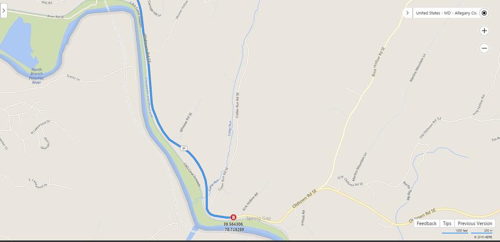
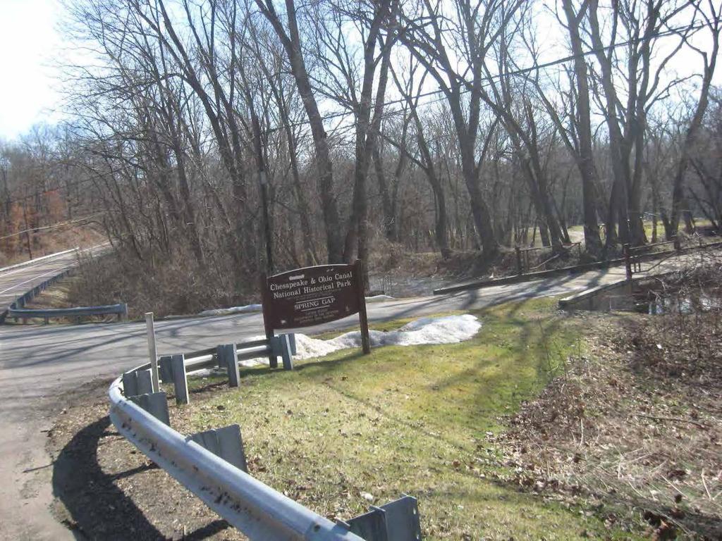
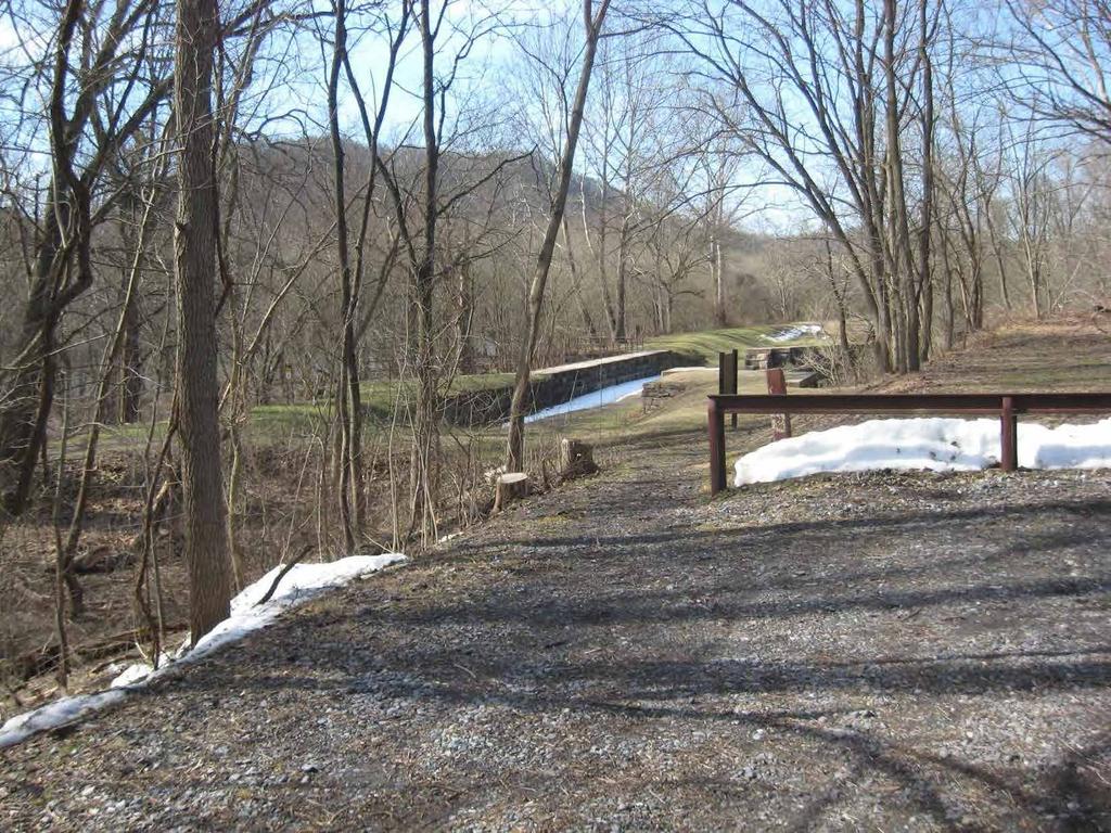
3 C & O Canal Trail Start to Spring Gap ( , ) Run Distance: 11.0 miles From parking lot, turn Left onto Canal St 95 feet Turn Left onto Howard St 328 feet Turn Right onto S Mechanic St.1 miles Continue onto MD-51 S/Industrial Blvd 7.6 miles Turn Right shortly after passing Kirk Hollow 230 feet Road on the left Turn Right into parking lot 361 feet End at Spring Gap (Total Distance) 7.9 miles NOTES: Grills, bathrooms, and camping are available at Spring Gap
4
 12.")
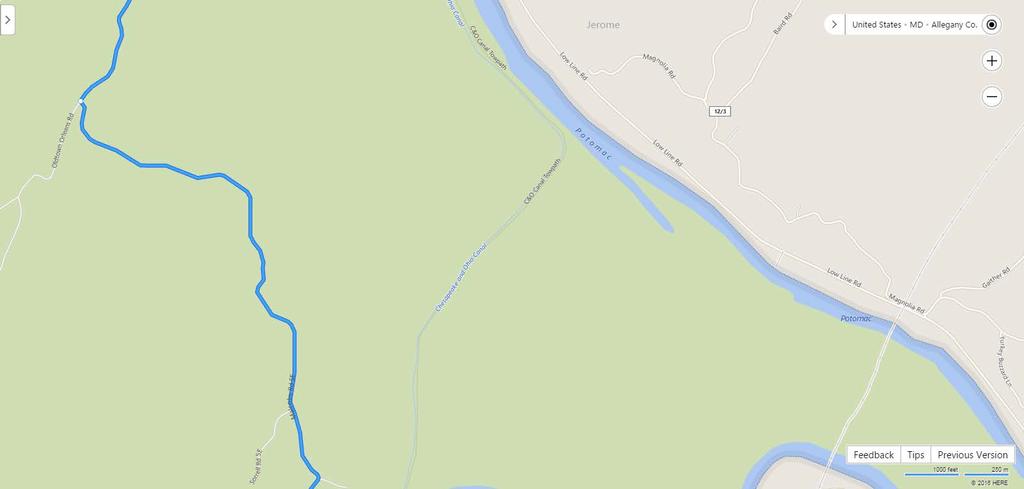
5 Spring Gap to Town Creek Aqueduct ( , ) Run Distance: 11.4 miles From the parking area, head back in the direction you came from Turn Right onto MD 51 S (Oldtown Road) 12.5 miles You will cross over the Town Creek Bridge Turn Right onto Town Creek C&O.2 miles Aqueduct Road Drive past the first access point.4 miles End at Town Creek Aqueduct (Total Distance) 12.6 miles NOTES: There is no bathroom and a small parking lot at Town Creek Aqueduct


6 This is the turn from MD 51 S onto Town Creek C&O Aqueduct Road
7
 5.")
8 Town Creek Aqueduct to Paw Paw ( , ) Run Distance: 5.8 miles From the parking area, head back to Town.5 miles Creek C&O Aqueduct Road Turn Right onto MD 51 S (Oldtown Road) 4.8 miles Turn Left at Paw Paw sign.1 miles Do not pass under the railroad bridge just past the turn End at Paw Paw (Total Distance) 5.4 miles NOTES: Runner and biker will each need a light for the tunnel along the towpath. Paw Paw has port-a-potties and camping. If you drive past the left turn into Paw Paw, there is a Liberty Gas station with a convenience store about 1 mile down the road. You ll cross into West Virginia shortly before arriving at the gas station.


9 This is the railroad bridge just past the left turn for Paw Paw
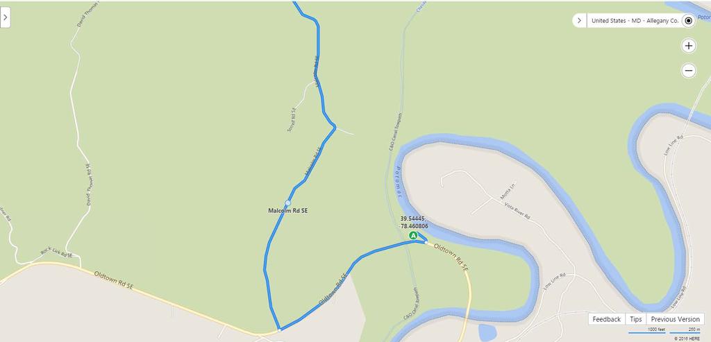
10 Paw Paw to Bond s Landing ( , ) Run Distance: 6.5 miles From the Paw Paw parking lot, head back towards MD 51 Turn Right onto MD 51 N (Oldtown Road).9 miles Drive past the Green Ridge Forest sign Turn Right onto Malcolm Road (dirt/gravel 1.2 miles road) There is no street sign; instead you should look for the United Methodist Church sign Bear Left at the fork to stay on Malcolm 2.1 miles Road You will be driving up a very steep hill Turn Right onto Oldtown Orleans Road 2.3 miles Look for the stop sign Turn Right onto Mertens Avenue 2.6 miles Turn Sharp Right onto Kasekamp Road 1.4 miles You will drive through two creeks Turn Sharp Right onto Bond s Landing.1 miles Road There is no street sign, instead look for the Bond s Landing sign End at Bond s Landing (Total Distance) 10.6 miles The towpath crosses the road NOTES: A 4WD or AWD vehicle is recommended for driving to Bond s Landing. Bond s Landing is very difficult to find for both drivers and runners/bikers. It also has very limited parking. Teams may want to have their runners/bikers continue on to 15 Mile Creek. There are no bathrooms at Bond s Landing.
11


12 This is the sign where you turn right onto Malcolm Road

13 This is the sign at the turn for Bond s Landing Road

14 Bond s Landing to 15 Mile Creek ( , ) Run Distance: 9.0 miles From Bond s Landing, follow Bond s.1 miles Landing Road back towards Kasekamp Road Turn Right onto Kasekamp Road 2.4 miles Turn Left onto Mertens Avenue 2.6 miles Turn Right onto Oldtown Orleans Road 2.4 miles Look for the stop sign Bear Right at the fork to stay on Oldtown 3.3 miles Orleans Road Drive past the Little Orleans Campground Turn Left onto Orleans Road.1 miles You will cross a bridge Turn Right onto High Germany Road.1 miles Turn Right immediately after crossing under >.1 miles the bridge and follow the road into the parking lot End at 15 Mile Creek (Total Distance) 11 miles The towpath crosses the road NOTES: Just after turning onto High Germany Road, there is a full-service restaurant that also offers to-go snacks and drinks. There are bathrooms in the restaurant and the parking lot as well as grills.


15 This is the sign at the right turn onto High Germany Road

16 15 Mile Creek to Deneen Road ( , ) Run Distance: 10.8 miles From the parking lot, head back to High 1.3 miles Germany Road Do NOT cross under the bridge; stay straight Turn Right onto Ziegler Road 4.3 miles Ziegler Road changes names to Pearre Road at the Aaron Straus National Guard Base You will cross over a one-lane bridge after the road changes names Bear Left onto Woodmont Road You will be driving uphill Turn Right onto MD 144 East (Western Pike) You will turn at the stop sign Turn Right onto Willow Road Bear Right at the fork to stay on Willow Road You will be driving up hill You will cross under a bridge End at Deneen Road (Total Distance) NOTES: No bathrooms 6.2 miles 2.8 miles 1.7 miles 17.2 Miles


17 This is the parking area at Deneen Road. The towpath is just across the wooden bridge.

18 Deneen Road to Little Tonolaway (Hancock) ( , ) Run Distance: 5.7 miles From the parking lot, head back up Deneen.1 miles Road and cross under the bridge Stay straight to get onto Willow Road 1.5 miles Bear Left to stay on Willow Road 2.8 miles Turn Right onto MD 144 East (National 3.0 miles Pike) Turn Right onto Pennsylvania Avenue.1 miles The turn is at a stop light and there is a sign for the C&O Canal Turn Right, then Left to cross over the.1 miles wooden bridge into the parking lot End at Little Tonolaway (Hancock) (Total 7.6 Miles Distance) NOTES: There are bathrooms and grills at Little Tonolaway. There is also a bike shop on Pennsylvania Avenue by the wooden bridge into the parking lot. Shortly before the turn onto Pennsylvania Avenue, you will pass a Sheetz with a gas station on your left.
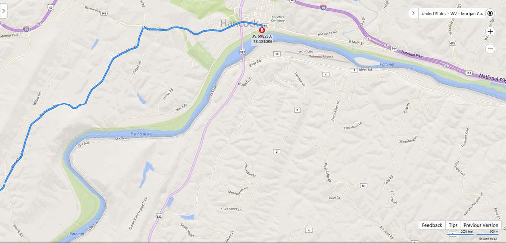
19

20 Little Tonolaway (Hancock) to Licking Creek ( , ) Run Distance: 8.3 miles From the parking lot return to Pennsylvania.2 miles Avenue Turn Right onto MD 144 East 1.2 miles Merge onto I70 East 5.5 miles Take the Left Exit to US 40 Indian Springs.3 miles Exit is for southbound only Turn Right onto Mile Marker Road.7 miles Turn immediately before bridge Mile Marker Road is only wide enough for one car You will cross under I70 End at Licking Creek (Total Distance) NOTES: The parking lot is very small. 7.9 miles
21

22 This is the parking area at Licking Creek.

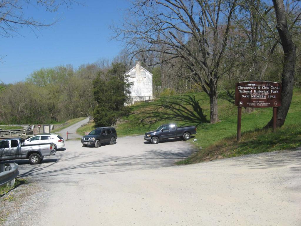
23 Licking Creek to Four Locks ( , ) Run Distance: 7.0 miles From the parking lot, take Mile Marker Road.7 miles towards US 40 Turn Right onto US 40 East 2.5 miles Turn Right onto MD 56 East (Big Pool 5.7 miles Road) Cross over I70 Pass the sign for McCoy s Ferry Road (C&O Canal) Turn Sharp Right onto Four Locks Road Bear Right onto Hasset Road Follow sign for the boat ramp.7 miles.2 miles Pass through the tunnel End at Four Locks (Total Distance) 9.8 miles NOTES: There are grills and a bathroom at Four Locks
24
 Bear Right at the fork to stay on MD 56 East 2.3 miles Turn Right onto Dam 5 Road 2.")
25 Four Locks to Dam 5 ( , ) Run Distance: 2.5 miles From the parking lot, head back through the.9 miles tunnel to Four Locks Road Turn Right onto MD 56 East (Big Pool.5 miles Road) Bear Right at the fork to stay on MD 56 East 2.3 miles Turn Right onto Dam 5 Road 2.7 miles Cross a one-lane bridge There is a country market at the stop sign Pass the first C&O access End at Dam 5 NOTES: No bathrooms 6.4 miles
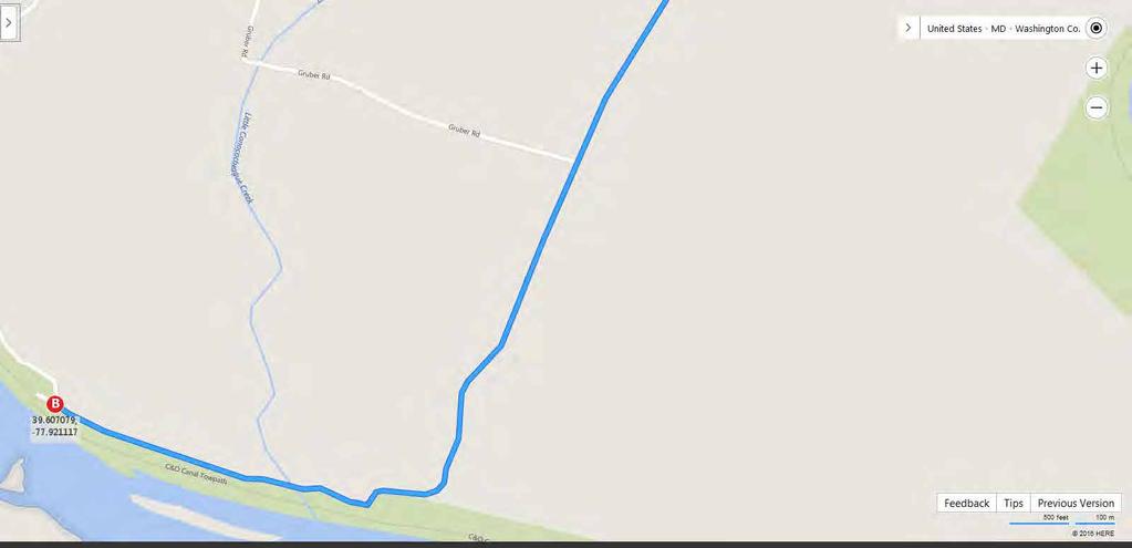
26
 Turn Right onto MD 68 (Clear Springs 4.2 miles Road) Look for the stop sign Turn Right onto US 11 South.")
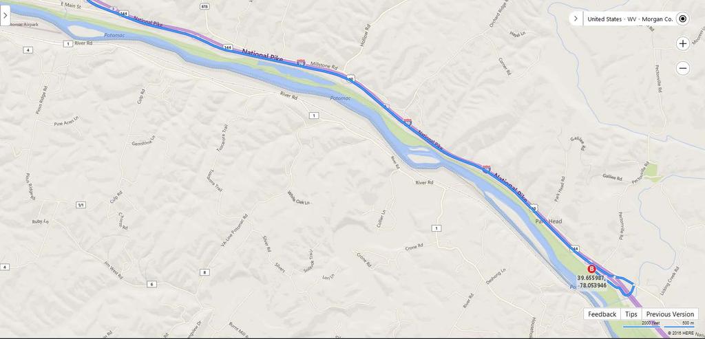
27 Dam 5 to Williamsport (Cushwa Basin) ( , ) Run Distance: 6.7 miles From the parking lot, take Dam 5 Road 2.7 miles towards MD 56 East Turn Right onto MD 56 East (Big Pool.5 miles Road) Turn Right onto MD 68 (Clear Springs 4.2 miles Road) Look for the stop sign Turn Right onto US 11 South.2 miles Stop light at the turn The entrance to the Williamsport parking lot will be in front of you right before the road curves to the left End at Williamsport (Total Distance) NOTES: There are bathrooms at Williamsport. 7.6 miles

28 This shows the entrance to the Williamsport parking lot.
 Stop light at the turn Turn Right onto MD 632 (Dam 4 Road).")
29 Williamsprt (Cushwa Basin) to Avis Mill Road (McMahon s Mill) ( , ) Run Distance: 11.7 miles From the Williamsport parking lot, take US 11.2 miles North towards MD 68 Turn Right onto MD 68 East 1.2 miles Pass under I81 Turn Right onto MD 63 South (Spielman 2.8 miles Road) Stop light at the turn Turn Right onto MD 632 (Dam 4 Road).8 miles Turn Right onto Dellinger Road Turn Left onto Avis Mill Road Pass the McMahon s Mill Camping sign to the end of the road.4 miles.7 miles End at McMahon s Mill (Total Distance) 6.1 miles NOTES: There is a port-a-potty at Avis Mill Road.
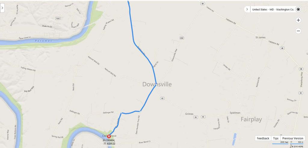
30
 3.6 miles Look for the stop sign Bear Left to Dam 4 area 1.")
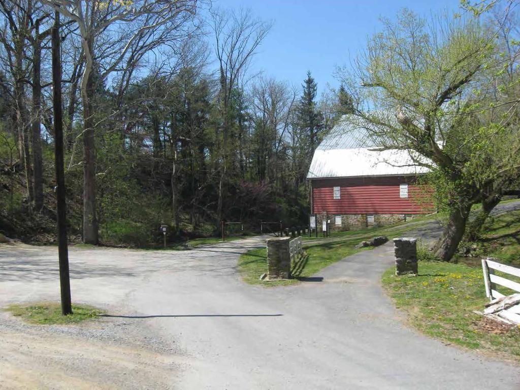
31 Avis Mill Road (McMahon s Mill) to Big Slackwater ( , ) Run Distance: 3.7 miles From the parking lot, take Avis Mill Road.7 miles towards Dellinger Road Turn Right onto Dellinger Road.4 miles Turn Right onto MD 632 (Dam 4 Road) 3.6 miles Look for the stop sign Bear Left to Dam 4 area 1.0 mile Drive past the first parking area 1.0 mile End at Big Slackwater (Total Distance) 6.7 miles NOTES: There is a port-a-potty at Big Slackwater.

32 This is the parking area at Big Slackwater
 2.7 2.7 R Woburn Rd 1.3 4.")

33 17 Leg 14: Big Slackwater to Taylor s Landing C&O Mile marker: Run Distance: 3.4 mi Driver Directions Dir Route Dist Cum Begin Big Slackwater Recreation Area Rtn MD 632 (Dam 4 Rd) R Woburn Rd R Taylor s Landing Rd End Taylor s C&O Sign P-S On side of Rd TZ On towpath via bridge (boat ramp access) N W Table Key: BL/BR = Bear Left/Right L = Left R = Right Rtn = Return Str = Straight TZ = Transition Zone X = Cross P- = Park S = Small - 1 vehicle/team, M = Medium - 2 /team, L = Large - 3 /team

 (If you hit MD 34, too far) R @ bottom of hill into parking 0.0 8.")
34 18 Leg 15: Taylor s Landing to Snyder s Landing Leg 16: Snyder s Landing to Lock 38 C&O Mile marker: C&O Mile marker: Run Distance: 4.2 mi Run Distance: 4.0 mi Driver Directions Driver Directions Dir Route Dist Cum Dir Route Dist Cum Begin Taylor s Landing Begin Snyder s Landing Str Taylor s Landing Rd Rtn Snyder s Landing Rd BR Bowie Rd; parallel to R Mondell stop sign towpath X Creek, Remsburg R MD 34 (Main St) Rd to remain on Bowie Rd L Canal Rd across from C&O BR Mondell Rd Admin HQ on R; (if you X R W Chapline stop sign Potomac River, too far) (If you hit MD 34, too far) bottom of hill into parking lot BR Snyder s Landing Rd End Lock R Into parking lot on R P-M In parking lot End Snyder s Landing 7.7 TZ On towpath X footbridge P-M In parking lot TZ On towpath via wooden bridge (boat ramp access) N W N W Table Key: BL/BR = Bear Left/Right L = Left R = Right Rtn = Return Str = Straight TZ = Transition Zone X = Cross P- = Park S = Small - 1 vehicle/team, M = Medium - 2 /team, L = Large - 3 /team


35 19 Table Key: BL/BR = Bear Left/Right L = Left R = Right Rtn = Return Str = Straight TZ = Transition Zone X = Cross P- = Park S = Small - 1 vehicle/team, M = Medium - 2 /team, L = Large - 3 /team
 1.9 1.9 Rtn Back Rd 0.9 0.")
 0.0 5.7 R sharp L Back Rd not marked (approx.")

36 20 Leg 17: Lock 38 to Dargan Bend Leg 18: Dargan Bend to Lock 31 C&O Mile marker: C&O Mile marker: Run Distance: 7.9 mi Run Distance: 6.9 mi Driver Directions Driver Directions Dir Route Dist Cum Dir Route Dist Cum Begin Lock Begin Dargan Bend Str Canal Rd (not L up hill) Rtn Back Rd BR To remain on Canal Rd R Harper s Ferry Rd R Harpers Ferry Rd BL Road bears C&O Canal Lock 34 X Bridge, BL to remain on R Keep Tryst Rd Harpers Ferry Rd Hoffmaster Rd to remain on Harpers Ferry Rd corner into parking lot (rd bends sharp to L) R sharp L Back Rd not marked (approx..5 mi after Mandokin C&O sign Dargan End Lock Bend End Dargan Bend 10.4 P-M In parking lot P-L In parking lot TZ On towpath. Caution when X live RR tracks TZ On towpath N W N W Table Key: BL/BR = Bear Left/Right L = Left R = Right Rtn = Return Str = Straight TZ = Transition Zone X = Cross P- = Park S = Small - 1 vehicle/team, M = Medium - 2 /team, L = Large - 3 /team


37 21 Table Key: BL/BR = Bear Left/Right L = Left R = Right Rtn = Return Str = Straight TZ = Transition Zone X = Cross P- = Park S = Small - 1 vehicle/team, M = Medium - 2 /team, L = Large - 3 /team
 0.2 0.2 Rtn Service rd 0.2 0.2 R US 340 E 0.")
 X Parking lot & train tracks 0.1 3.8 R Highway 15 6.8 14.3 R Service rd 0.2 4.0 L Clay Rd (MD 28) 1.0 15.3 X Towpath to parking lot 0.0 4.")
38 22 Leg 19: Lock 31 to Lock 30 - Brunswick Leg 20: Lock 30-Brunswick to Point of Rocks C&O Mile marker: C&O Mile marker: Run Distance: 3.0 mi Run Distance: 6.8 mi Driver Directions Driver Directions Dir Route Dist Cum Dir Route Dist Cum Begin Lock Begin Lock 30-Brunswick Str On Keep Tryst Rd (up hill) Rtn Service rd R US 340 E X Train tracks & parking lot R MD R E. Potomac St R MD 478 (Knoxville Rd) flashing yellow light (Ninth St) R Maple stop light stop light (becomes MD E) X Parking lot & train tracks R Highway R Service rd L Clay Rd (MD 28) X Towpath to parking lot R Immediate right at C&O sign End Lock 30-Brunswick (under highway Bridge) End Point of Rocks P-L In parking lot under highway bridge P-M In parking lot across bridge TZ On C&O milepost 55 TZ On towpath at brown sign by bridge N W N W Table Key: BL/BR = Bear Left/Right L = Left R = Right Rtn = Return Str = Straight TZ = Transition Zone X = Cross P- = Park S = Small - 1 vehicle/team, M = Medium - 2 /team, L = Large - 3 /team


39 23 Table Key: BL/BR = Bear Left/Right L = Left R = Right Rtn = Return Str = Straight TZ = Transition Zone X = Cross P- = Park S = Small - 1 vehicle/team, M = Medium - 2 /team, L = Large - 3 /team

 0.4 1.5 R @ MD 85 to remain on 3.3 3.3 BR On MD 28 1.2 2.7 MD 28 BL On MD 28 (Damestown Rd) 2.3 5.0 R Mouth of Monocacy Rd 1.1 4.")
40 24 Leg 21: Point of Rocks to Mouth of Monocacy Leg 22: Mouth of Monocacy to White s Ferry C&O Mile marker: C&O Mile marker: Run Distance: 6.0 mi Run Distance: 6.7 mi DO NOT run/bike on the aqueduct due to support beams & rebar causing dangerous footing; Walk across aqueduct! Driver Directions Driver Directions Dir Route Dist Cum Dir Route Dist Cum Begin Point of Rocks Begin Mouth of Monocacy Rtn Parking lot to MD 28E Rtn Mouth of Monocacy Rd R MD 28E R MD 28 E (Dickerson Rd) MD 85 to remain on BR On MD MD 28 BL On MD 28 (Damestown Rd) R Mouth of Monocacy Rd R MD 109 (Beallsville Rd) R MD 107 (Fisher Rd) End Mouth of Monocacy 4.4 intersection River Rd & P-M In parking lot White s Ferry Rd TZ On towpath End White s Ferry 13.6 P-L In parking lot TZ Where towpath X rd Table Key: BL/BR = Bear Left/Right L = Left R = Right Rtn = Return Str = Straight TZ = Transition Zone X = Cross P- = Park S = Small - 1 vehicle/team, M = Medium - 2 /team, L = Large - 3 /team


41 25 Table Key: BL/BR = Bear Left/Right L = Left R = Right Rtn = Return Str = Straight TZ = Transition Zone X = Cross P- = Park S = Small - 1 vehicle/team, M = Medium - 2 /team, L = Large - 3 /team
 1.0 1.")
 1.5 3.4 P-S In parking lot Decent toilets BL Becomes River Rd when the 1.5 4.9 road narrows to one lane near brown Poolesville sign. TZ On towpath Str Pass W. Willard Rd on L 0.2 5.")
42 26 Leg 23: White s Ferry to Edwards Ferry Leg 24: Edwards Ferry to Sycamore Landing Rd C&O Mile marker: C&O Mile marker: Run Distance: 4.7 mi Run Distance: 3.6 mi Driver Directions Driver Directions Dir Route Dist Cum Dir Route Dist Cum Begin White s Ferry Begin Edwards Ferry L/Rtn White s Ferry Rd Rtn Edwards Ferry Rd) R Edwards Ferry Rd(1) R W. Offutt Rd brick pillar on the left. Turn right at the fork and left at the T towards gate. Stay on paved road. End Edwards Ferry 5.5 Str Becomes Mt. Nebo Rd (2) P-S In parking lot Decent toilets BL Becomes River Rd when the road narrows to one lane near brown Poolesville sign. TZ On towpath Str Pass W. Willard Rd on L R Sycamore Landing Rd (may be muddy/slippery End Sycamore Landing Rd 5.9 P-M In parking lot TZ On towpath (1) As an alternative, you could take River Road, the first right out of the White s Ferry parking lot. This is a gravel country road that will also go to Edwards Ferry Road. See map inset. (2) W. Offutt Rd. turns to the left here. Go straight. Table Key: BL/BR = Bear Left/Right L = Left R = Right Rtn = Return Str = Straight TZ = Transition Zone X = Cross P- = Park S = Small - 1 vehicle/team, M = Medium - 2 /team, L = Large - 3 /team


 End Riley s Lock Rd 5.5 Str Pass Admiral s Way 0.1 7.")

43 27 Leg 25: Sycamore Landing Rd to Riley s Lock Rd Leg 26: Riley s Lock Rd to Swain s Lock C&O Mile marker: C&O Mile marker: Run Distance: 4.4 mi Run Distance: 6.1 mi Driver Directions Driver Directions Dir Route Dist Cum Dir Route Dist Cum Begin Sycamore Landing Rd Begin Riley s Lock Rd Rtn Sycamore Landing Rd Rtn Riley s Lock Rd R River Rd R River Rd R Riley s Lock Rd (Note: do R MD 190 (River Rd)) not use Tschiffley Mill Rd) End Riley s Lock Rd 5.5 Str Pass Admiral s Way P-L In parking lot R Swain s Lock Rd TZ On towpath End Swain s Lock 7.7 P-S In parking lot TZ On towpath Table Key: BL/BR = Bear Left/Right L = Left R = Right Rtn = Return Str = Straight TZ = Transition Zone X = Cross P- = Park S = Small - 1 vehicle/team, M = Medium - 2 /team, L = Large - 3 /team


44 28 Leg 27: Swain s Lock to Lock 10 Leg 28: Lock 10 to Fletcher s Boathouse C&O Mile marker: C&O Mile marker: Run Distance: 7.9 mi Run Distance: 5.6 mi Driver Directions Driver Directions Dir Route Dist Cum Dir Route Dist Cum Begin Swain s Lock Begin Lock Rtn Swain s Lock Rd Str Clara Barton Parkway R MD 190 (River Rd) Str Pass Chain Bridge Rd R MD 189 (Falls Rd) Str X under train trestle L Macarthur Blvd R sharp Fletcher s Boathouse R R Clara Barton Parkway Note: after X under I-495 you will see a sign for Lock 10; although called Persimmon Tree Rd, there is NO direct access from that rd. Lock Note: SHARP R white building; entrance is 180 degree turn, very narrow, poorly marked. Tall vehicles must park in 1st parking lot; tunnel with low clearance to lower lot. If you miss the initial turn, BL onto Reservoir Rd 0.5 mi; R onto Macarthur Blvd 1.0 mi; R onto Canal Rd 1.5 mi; Fletcher s entrance will be on your L. End Lock End Fletcher s Boathouse 5.8 P-M In parking lot P-M In parking lot TZ On towpath, follow trail from parking lot X lock TZ On towpath X footbridge Table Key: BL/BR = Bear Left/Right L = Left R = Right Rtn = Return Str = Straight TZ = Transition Zone X = Cross P- = Park S = Small - 1 vehicle/team, M = Medium - 2 /team, L = Large - 3 /team
45 Running and Driving Directions from Fletcher s Boathouse to the Finish As you enter Georgetown, the trail has several areas that split off to form other trails. Ensure you stay on the C&O trail. There is some construction on the trail and you have to cross over the canal at one point. When crossing streets with traffic, look both ways and remember that even though you have the right of way, cars do not always stop. The trial ends in Georgetown and intersects the Rock Creek trail. When you get to this point on the trail, turn to the right and proceed down the trail toward the Potomac River. Be mindful of traffic merging onto side streets. They don t always stop for runners. You will be on a wide paved path that follows the Potomac River on your right. On your left will be the infamous Watergate building. You will pass the Kennedy Center. Shortly after passing the Kennedy Center you will pass under the Roosevelt Bridge. The trail makes a semi-circle just after the bridge. Immediately after the semi-circle, cross over the road and head on a trail that takes you past a series of volleyball courts. If you are following the sidewalk up toward the Lincoln Memorial, you are going the wrong way. After the volleyball courts you will pass the steps leading up to the Lincoln Memorial on your left, the Potomac River will be immediately to your right and the Memorial Bridge will be in front of you. This is what you should see.


46 The Memorial Bridge heading toward West Potomac Park After you pass under the Memorial Bridge you will be entering West Potomac Park. Here is the sign for the park. Follow the path through West Potomac Park to the end. You will cross over a small bridge that leads you into the East Potomac Park. The Thomas Jefferson Memorial is off to your left as you pass over this bridge. Continue on the path toward the East. Before you pass under the 14 th St Bridge you will see a set of steps that go up next to the bridge. Here is a picture of the steps.

47 Up these steps to access the bridge for Potomac crossing These steps get you up to the trail that leads over the bridge. You must carry or push the bicycle up the path next to the steps. At the top of the steps, make a U-turn to cross over the bridge. On the other side of the bridge, you will have to loop around and down toward the Potomac River. You will pass under the bridge you just crossed and run toward Regan National Airport. This trail is the Mt. Vernon trail. From this point onward, you will remain on the Mt. Vernon trail. NOTE: Pay close attention to the signs so that you do not veer off the trail onto another intersecting trail. As you pass Regan National Airport last parking lot, the trail splits. Bear to the RIGHT onto the Mt. Vernon trail. Run along the George Washington Parkway following the trail toward Old Town Alexandria. After passing Daingerfield Island, the trail will split again. Bear to the left and follow the trail along the Potomac River. As the trail gets closer into town, you will have to follow the railroad tracks. The Mt. Vernon trail appears to end at Pendleton Street. Turn to the left and follow the road to N. Union Street. This is the trail through Old Town Alexandria. There is a Starbucks at the corner of King Street and N. Union Street. (no product endorsement here just information) NOTE: The road is not closed to traffic. Exercise caution while running/riding through Old Town Alexandria on N. Union Street. Due to construction, the trail follows a side street as opposed to a true trail. Run along Union Street following the signs for the Mt. Vernon detour signs. Turn RIGHT on
48 Franklin Street. Continue to follow the detour signs until you return to the paved trail. After you pass Old Town Alexandria, you will pass under I-495. The trail picks up as a paved trail adjacent to George Washington Parkway and the Potomac River. The trail markers start at mile 9. You will be only 7 miles from the finish. Your next exchange point is a rest area and parking lot just past mile marker 8; Belle Haven Marina. The trail can become very congested after this point. Be careful of other runners/walkers as well as cyclists using the trail. After mile marker 6, you will enter a residential area. The trail follows the road. At the first intersection, the trail crosses over the small bridge and then you will make a hard left onto the trail. FOLLOW THE SIGNS. After mile marker 3, you will follow the trail to Fort Hunt Park and the finish. There is a water fountain at the bottom of the curve of the trail that is adjacent to the entrance for the park. If you run back under George Washington Parkway and see mile marker 2.you have gone too far. Turn around and come back to us.
49 Driving Directions and Check points Exchange point Fletcher s Boat House: Nearest intersections are Canal Road NW and Reservoir Road NW N W Elev 76 ft Depart Fletcher s Boat House/Landing heading SE on Canal Road. Stay RIGHT on Canal Road toward Georgetown/DC. After 2 miles, follow signs to M Street (LEFT lane). You will pass Georgetown University on your left as you come into Georgetown. Landmarks - Key Bridge & Potomac River on right Dixie Liquor on left Drive through Georgetown on M street. Do not merge onto Key Bridge or Whitehurst Freeway. You will pass the famous Georgetown Cupcakes store on your left. Unfortunately, they do not open until 10 a.m. Turn RIGHT onto 30 th Street. At four-way Stop Sign, turn LEFT onto K Street. Turn RIGHT at next Stop Sign onto Rock Creek Parkway. Thompson Boat Center is on your right as you make the turn. The paved path on the right is the trail the runners will be taking. Pass by the Watergate buildings and the Kennedy Center on your left as you drive along Rock Creek Parkway. After you pass under the Roosevelt Bridge, just past the Kennedy Center, follow Rock Creek Parkway to the LEFT toward downtown. WARNING: Do not go straight up the road toward the Lincoln Memorial. Stay in RIGHT hand lane to follow the Potomac River, pass under the Memorial Bridge and arrive at West Potomac Park. Exchange Point in West Potomac Park: N W Elev 2 ft This is located at the eastern end of the West Potomac Park. After exchange of runner/biker, you will be making a U-turn to head back out of the park to Independence Avenue. The runner/biker will continue eastward to the bridge for crossing over the Potomac River.
50 Depart West Potomac Park by making a U-turn and follow signs for I-395/Washington Memorial. Make RIGHT turn out of park. Stay in right lane. After crossing small bridge, bear RIGHT toward Jefferson Memorial and signs to I-395. LEFT lane to merge onto I-395 South. Cross over Potomac River on 14 th Street bridge/i-395. After the bridge, merge onto George Washington Parkway South toward Reagan National Airport and Old Town Alexandria. Exchange point in Daingerfield Island/Washington Sailing Marina: N W Elev -5 ft Turn LEFT into parking lot of Washington Sailing Marina. Exit parking lot LEFT onto George Washington Parkway south toward Old Town Alexandria. As you enter Old Town Alexandria George Washington Parkway becomes N. Washington Street. As you pass through Old Town Alexandria, S. Washington Street turns back into George Washington Parkway. Exchange point in Belle Haven Marina: N W Elev 2 ft Nearest address is th Street Alexandria, VA There is a Shell gas station near here. Turn LEFT into Belle Haven Marina. If you have a trailer in tow or a larger vehicle, park along the road as you approach the marina. Cars and trucks without trailers can turn left into the parking area at Belle Haven Park. There are restrooms and a water fountain at this park. It is 6 miles to the finish area. This parking area may be busy as several local running groups utilize this area for their training runs. Exit Belle Haven Marina and turn LEFT onto George Washington Parkway. Follow George Washington Parkway until the exit for Fort Hunt Park/Fort Hunt Road on your RIGHT. Follow the signs to the park and look for the finish celebration. CONGRATULATIONS!!!
Directions to Frequently Visited C & O Canal Locations
 Directions to Frequently Visited C & O Canal Locations Seneca Creek Montgomery County, Maryland Pass town of Potomac and Falls Road and continue west to Seneca Rd. Turn left on Seneca Rd. and continue
Aurora Hills. Getting There
 Aurora Hills Aurora Hills is neighborhood near Crystal City and Pentagon City. Ball fields, ball courts, a very short trail, and a combination ibrary/fire Station are the central pieces of a recreation
BRR Leg 1 (4.0 miles, Easy)
") BRR Leg 1 (4.0 miles, Easy) Min 3881 Max 4948 Ascent +36 Descent -1027 0.0 Start (Grayson Highlands State Park Visitor Center) 4.0 Grayson Highlands State Park Office & Gate, on L (EZ 1) Leg Notes: Minimal
BRR Leg 1 (4.0 miles, Easy) Min 3881 Max 4948 Ascent +36 Descent -1027 0.0 Start (Grayson Highlands State Park Visitor Center) 4.0 Grayson Highlands State Park Office & Gate, on L (EZ 1) Leg Notes: Minimal
Difficult Run Stream Valley Park
 Difficult Run Stream Valley Park The more intense mountain bikers have known about for Difficult Run for some time. Equestrians have known it longer. Eight miles of unpaved trail, the Rails to River Trail
Great Falls National Park, Virginia
 Great Falls National Park, Virginia Despite having grown-up in the area, I had not seen Great Falls until I was near an adult. I used to think places like Great Falls only existed someplace else that you
GREAT ALLEGHENY PASSAGE TRIP PACKAGES by Bike the GAP exclusively for Golden Triangle Bike Rental 2014 SEASON. 7 DAY. PITTSBURGH TO DC Package
 GREAT ALLEGHENY PASSAGE TRIP PACKAGES by Bike the GAP exclusively for Golden Triangle Bike Rental 2014 SEASON 7 DAY. PITTSBURGH TO DC Package Cost. $1,299 per person, based on double occupancy. Includes
SWD Sport and Wellness of Danbury (formerly Beaver Brook), 17 Starr Rd, Danbury
, 17 Starr Rd, Danbury") SWD Sport and Wellness of Danbury (formerly Beaver Brook), 17 Starr Rd, Danbury 203-743-7676 Take RT 84 East to Exit 7. Exit left onto RT 7 North. Take first exit, Federal Road, to light at bottom of exit
SWD Sport and Wellness of Danbury (formerly Beaver Brook), 17 Starr Rd, Danbury 203-743-7676 Take RT 84 East to Exit 7. Exit left onto RT 7 North. Take first exit, Federal Road, to light at bottom of exit
Rock Creek Park, MD - Lake Needwood
 ock Creek Park, MD - Lake Needwood Lake Needwood, is a reservoir located at the end of the north end of the ock Creek hiker-biker trail. At the other end, ock Creek empties into the Potomac iver near Thompson
TETRA TECH AMT 1515 Wilson Blvd. Suite 1100 Arlington, VA USA (703)
") DIRECTIONS TO HEADQUARTERS Included in this Guide: Directions to Tetra Tech 1 AMT Headquarters Parking Information 1 FAA National 2 Headquarter Locations Shuttle Schedule 2 Service to FAA Buildings Closest
DIRECTIONS TO HEADQUARTERS Included in this Guide: Directions to Tetra Tech 1 AMT Headquarters Parking Information 1 FAA National 2 Headquarter Locations Shuttle Schedule 2 Service to FAA Buildings Closest
Welcome! An on-site business center features a menu of options and offers high-speed Internet access (surcharge).
.") Welcome! The Georgetown University Hotel & Center is located within a mile of Historic Georgetown with all of its shops, restaurants, and galleries. Among the dining options at the hotel are The Faculty
Welcome! The Georgetown University Hotel & Center is located within a mile of Historic Georgetown with all of its shops, restaurants, and galleries. Among the dining options at the hotel are The Faculty
ATL. Advanced Technology Laboratories. Maps and Locations
 ATL Maps and Locations TABLE OF CONTENTS Lockheed Martin is headquartered in Cherry Hill, NJ with offices in Arlington, VA Eagan, MN Kennesaw, GA 3 Cherry Hill 4 Driving Directions To 5 Driving Directions
Troop 349. Biking Campout down the. 55 miles on the C&O Canal Towpath
 Troop 349 Biking Campout down the 55 miles on the C&O Canal Towpath Harper s Ferry, WV to Washington, DC Sat & Sun, May 21-22, 2011 Deadline for permission slip & payment: Tuesday, May 17 1 Discription:
Training Site Directions
 Training Site Directions Click on a facility to go to the directions BRIDGEPORT OFFICE. CENTRAL OFFICE 55 Farmington Ave 25 Sigourney Street (Former Central Office) Page 2 Page 2 DANBURY OFFICE HARTFORD
Gorgeous Relay Driving Directions September 16, 2018
 2018 Gorgeous Relay Legs 1-3 Gorgeous Relay Start: Mark O. Hatfield Trailhead, Mosier Take I-84 to Exit 69, Mosier. Follow the brown signs for the Historic Columbia River Hwy State Trail. The Start Line
BRR Leg 1 (3.9 miles, Easy)
") BRR Leg 1 (3.9 miles, Easy) Min 3901 Max 4919 Ascent +21 Descent -1031 0.0 Start (Grayson Highlands State Park Visitor Center) 3.9 Grayson Highlands State Park Office & Gate, on R (EZ 1) Leg Notes: Minimal
BRR Leg 1 (3.9 miles, Easy) Min 3901 Max 4919 Ascent +21 Descent -1031 0.0 Start (Grayson Highlands State Park Visitor Center) 3.9 Grayson Highlands State Park Office & Gate, on R (EZ 1) Leg Notes: Minimal
Directions to Gathering/other Events:
 Directions to Gathering/other Events: Scroll down the list below (churches are in alphabetical order)!! Andrews Chapel UMC: From Conway: From Conway: Take 501 to Highway 31 North. Take the Highway 9 exit
Leg 1 (4.0 miles, Easy)
") Leg 1 (4.0 miles, Easy) Leg Description: Steady, but controlled downhill (paved). Leg Notes: Great views of the Grayson Highlands balds and mountains. Watch for wild ponies. 0.0 Grayson Highlands State
Leg 1 (4.0 miles, Easy) Leg Description: Steady, but controlled downhill (paved). Leg Notes: Great views of the Grayson Highlands balds and mountains. Watch for wild ponies. 0.0 Grayson Highlands State
Weekly East Tennessee Construction Report for May 31-June 6, 2018
 Weekly East Tennessee Construction Report for May 31-June 6, 2018 Thursday, May 31, 2018 01:30pm ANDERSON COUNTY, SR 62 between Union Valley Road and SR 162: Motorists should be alert for possible lane
General Information for Camp George Washington University:
 General Information for Camp George Washington University: Thank you for choosing Lavner Camps! We are very excited for an amazing summer! Below is some need-to-know information for our summer camps at
Black Hill Regional Park, Little Seneca Lake
 Black Hill Regional Park, ittle Seneca ake ittle Seneca ake, in Black Hill Regional Park, is a reservoir created after a previous drought struck the Washington area. The park is under Maryland-National
BG Peter D. Hidalgo (Retired) Internment at Arlington National Cemetery, Virginia
 Internment at Arlington National Cemetery, Virginia") BG Peter D. Hidalgo (Retired) Internment at Arlington National Cemetery, Virginia SERVICE Date: Tuesday, February 17, 2009 Time: 1100 Please arrive at Arlington National Cemetery by 10:30 and proceed to
BG Peter D. Hidalgo (Retired) Internment at Arlington National Cemetery, Virginia SERVICE Date: Tuesday, February 17, 2009 Time: 1100 Please arrive at Arlington National Cemetery by 10:30 and proceed to
Telluride-to-Moab Alternative Singletrack Options
 Telluride-to-Moab Alternative Singletrack Options Day 1 Day 1 Alternate 1: Galloping Goose to Deep Creek. 18.4 miles, ascent 3,530ft, descent 1,388ft. This is fun, flowey, moderate to intermediate singletrack
CORTLANDT Charles Cook Pool (914) Furnace Dock Road/Cortlandt Manor/10567 From Yorktown, take Route 202 west. Go past Cortlandt Farm Mark
 Furnace Dock Road/Cortlandt Manor/10567 From Yorktown, take Route 202 west. Go past Cortlandt Farm Mark") BEDFORD GOLF & TENNIS Club (914) 234-4106 535 Cantitoe Street/Bedford/10506 Located on route 22 approximately one mile east of Bedford Village and one mile west of Bedford Center Road. Pool located past
BEDFORD GOLF & TENNIS Club (914) 234-4106 535 Cantitoe Street/Bedford/10506 Located on route 22 approximately one mile east of Bedford Village and one mile west of Bedford Center Road. Pool located past
UMASS CROSS-COUNTRY Trails
 UMASS CROSS-COUNTRY Trails 1) EGG (43 min) (A) From Cage proceed to North Pleasant street (by campus pond). Make left and head toward LGRT and pass School of Education. Pass Puffton Apt complex (on left)
EUSTACE ICE HOCKEY TRAVEL DIRECTORY
 EUSTACE ICE HOCKEY TRAVEL DIRECTORY American Hockey Center, Wall Take Route 295 North until the exit for 195 East. Take 195 East to exit 35B, Shore Points/Route 34 North. Follow 34 North to Wyckoff Road,
* Short term resurfacing projects are not included in this listing. 4T39.07 Project: Annual Rural County Sign Improvements, Genesee/Orleans Counties
 New York State Department of Transportation 2008 Highway/Bridge Construction Projects * Short term resurfacing projects are not included in this listing. Genesee 4T39.07 Project: Annual Rural County Sign
Datum on benchmarks All benchmarks with a Township name and number are on 1929 datum:. All benchmarks with a four-digit number are on 1988 datum:
 Datum on benchmarks All benchmarks with a Township name and number are on 1929 datum:. All benchmarks with a four-digit number are on 1988 datum: LAWRENCE 2 Destroyed 8/29/05 TG General coordinates: 10800E
DIRECTIONS TO THE FIELDS
 DIRECTIONS TO THE FIELDS Northwest Connecticut Babe Ruth League AVON AVON HIGH SCHOOL -Traveling east on Route 44, take a right onto Route 167. Continue on Route 167 past the Avon Middle School. The field
Leesburg. Getting There
 eesburg eesburg embodies the historic nature of oudoun County better than does Ashburn. As of 1999, it is on the boundary line of suburbia and the country. It s not only the largest town in oudoun County,
Section 7: Pick Up Where You Left Off! S-Tree Road over the Todd Road
 2018 TRACE NOTES Helpful information for your adventure on Section 7 of the Hiker Challenge. Start Point S-Tree Rd. End Point Intersection Todd Rd. / Hale Ridge Rd. WEATHER DECISION Weather Alert!!!! Potential
C &O Canal. {TRAIL to HISTORY} SHEPHERDSTOWN SHARPSBURG WILLIAMSPORT.
 C &O Canal {TRAIL to HISTORY} SHEPHERDSTOWN SHARPSBURG WILLIAMSPORT www.canaltrust.org C &O Canal {TRAIL to HISTORY} Take a journey into the rich history of our Canal Towns along the C&O Canal towpath.
Directions to Soil Judging Practice Pits. Lost call Jim Turenne cell , pit location are posted at:
 Directions to Soil Judging Practice Pits. Lost call Jim Turenne cell 401-255-6206, pit location are posted at: http://maps.google.com/maps/ms?hl=en&ie=utf8&msa=0&ll=41.508577,- 71.523743&spn=0.447349,0.829468&z=10&msid=113798583893585652288.0
Road Construction Ahead January-April 2015 NORTHWEST REGION
 NORTHWEST REGION 1 Interstate 64 Augusta, Nelson, Albemarle counties: Installing communications conduit in median for active traffic management system on Afton Mountain. Periodic left-shoulder closures,
Marilla Reservoir to Chestnut Ridge via Marilla Trails and Bullis Hollow Trail east to west
 USGS topographic maps useful to this hike are the Bradford and Stickney 7.5 minute sectionals. These notes are designed to assist in identifying distance and location using geophysical and man-made characteristics
Oak Creek Assembly of God FOR YOUR SAFETY
 Oak Creek Assembly of God New York City-"The Big Apple" 6 Days/5 Nights Departing from: Start Date: Thursday, May 22, 2014 Oak Creek Assembly of God Church (South Side by Door #10) 7311 South 13th Street
This path goes past an old tree nursery and sawmill. After 800m it crosses over a lane. Follow the bridleway fingerpost into the woods.
 FRENSHAM PONDS 11K CIRCULAR TRAIL 2½ HRS GU10 2DA This magnificent heathland trail starts in woodland and then brings you out onto the open heather of Frensham Common, with no roadwork! The route runs
Columbia, Maryland - Village of Owen Brown
 Columbia, Maryland - Village of Owen Brown From the Village of Owen Brown, good trails stretch to other neighboring Columbia villages. Mostly following stream valleys, the trails go to and from schools
= Stops. = Restrooms
 = Stops = Restrooms Restrooms are located near the Lake Elkhorn pavilion Safety Tips 1.Be courteous. 2.Travel at a safe speed. 3.Use your bell or announce: passing on your left. 4.Remember there are people
Eakin Community Park. Getting There
 Eakin Community Park Quiet woods along the Accotink Creek are the hallmark of Eakin Community Park. Actually a string of smaller parks, Eakin is made-up of Mantua Park, Kern Drive Park, Eakin Park, Woodburn
Jackson Miles Abbott Wetlands Refuge/Fort Belvoir
 Jackson Miles Abbott Wetlands efuge/fort Belvoir Over the course of millions of years the Potomac iver has gradually shifted its course and sediments have filled-in its old river bed. The main river once
The TransAm Eastern Express - Westbound Map Set #12B Waynesville, OH to Connersville, IN 69.0 Miles / Cumulative Climbing: 2,685
 The TransAm Eastern Express - Westbound Map Set #12B Waynesville, OH to Connersville, IN 69.0 Miles / Cumulative Climbing: 2,685 PART #1 WAYNESVILLE TO FRANKLIN, OH FRANKLIN EAST 4TH STREET I - 75 The
Discover Historic Burlington A 10-mile self-guided tour
 Discover Historic Burlington A 10-mile self-guided tour 12 Colchester Causeway 10 Leddy Park NORTH AVE. LEDDY PARK ROAD 11 Ethan Allen Park Winooski River 13 17 Ethan Allen Homestead 9 North Beach NORTH
Vienna. Getting There
 Vienna Like its famous and older German namesake, but on a smaller scale, Vienna, Virginia has a charm to it. Becoming increasingly more cosmopolitan, foreign restaurants, bagle and coffee shops line Maple
Bankhead Lake TWO PARCELS AND 1 LOT FOR SALE
 OVERVIEW NORTH PARCEL ACRES: 46 WATERFRONT: 1,227 Front Feet PRICE: $350,000 PER ACRE: $7574 PER FRONT FT. $285 SOUTH PARCEL ACRES: 22 WATERFRONT: 1,381 Front Feet PRICE: $295,000 PER ACRE: $13,170 PER
SOUTHEAST BOULEVARD Planning Study Washington, DC. Progress Drawings October 6, 2014
 Existing Conditions Site Plan CONGRESSIONAL CEMETERY SOUTHEAST BOULEVARD Planning Study Concept A (formerly A-1) Site Plan Concept A (formerly A-1) Concept A proposes an expansion of the Capitol Hill neighborhood
Greenbush Town Hall / Fire Station
 Page 1 of 18 Course Description Greenbush Town Hall / Fire Station Both races start in front of the Greenbush Town Hall / Fire Station, just south of Highway 23 on Sugarbush Road. Parking will be in the
We are only 3.6 miles from the Portland Bridge. You cannot see our house from the street.
 We are only 3.6 miles from the Portland Bridge. You cannot see our house from the street. FROM: RT. 80 - EXIT 4B FROM EXIT 4B, NJ, NY, Points East of exit 4B (Columbia/Portland) traveling Westbound on
IOWA ORNITHOLOGISTS' UNION - Birding Sites in Linn County
 IOWA ORNITHOLOGISTS' UNION - Birding Sites in Linn County Printed on 6/15/2018 Bever Park (ebird Hotspot) GPS Coordinates: 41.9851219,-91.6269125 Restrooms Parking Trails ADA Accessible Trails Boyson Trail
The TransAm Eastern Express - Westbound Map Set #23 Watkins Mill State Park, MO to Atchison, KS 66.0 Miles / Cumulative Climbing: 2,955
 The TransAm Eastern Express - Westbound Map Set #23 Watkins Mill State Park, MO to Atchison, KS 66.0 Miles / Cumulative Climbing: 2,955 PART #1 WATKINS MILL STATE PARK TO PARADISE, MO PARADISE CYCLING
ANITA LOUISE EHRMAN - Greenway Avenue/Armonk/10504
 Directions to Area Swim Clubs: ANITA LOUISE EHRMAN - Greenway Avenue/Armonk/10504 From north, take 684 south to exit 3, left at end of exit ramp onto route 22 north, left at blinker light at Yellow Barn
Westchester county swim conference 2003 DIRECTIONS
 Westchester county swim conference 2003 DIRECTIONS AMACKASSIN CLUB 557 Palisades Ave. Yonkers, NY 10703 476-6460 Saw Mill River Parkway to Executive Blvd. to Broadway (Rte. 9). Left on Broadway to Roberts
Race Date and Start Time: The Washington Crossing 15K will be held on Saturday, August 12 th, The race will begin promptly at 5:00pm.
 Race Date and Start Time: The Washington Crossing 15K will be held on Saturday, August 12 th, 2017. The race will begin promptly at 5:00pm. Packet Pick-up: Packet pick-up will be held on race day, Saturday,
TENNESSEE DEPARTMENT OF TRANSPORTATION Project Status. No Projects Under Development in Blount County
 SR-33 No Projects Under Development in Blount County PIN: 118351.00 FROM OLD KNOXVILLE PIKE TO EAST LINCOLN ROAD Length - 0.6 (Intersection Improvements and Signals) SR-33 US-411 PIN: 118422.00 INTERSECTION
GUIDE TO THE GREAT EASTERN TRAIL IN TENNESSEE
 GUIDE TO THE GREAT EASTERN TRAIL IN TENNESSEE FIRST EDITION, SEPTEMBER 2011 Covers Section TN1 Base of Lookout Mountain to Soddy Daisy, TN THIS GUIDE IS NOT FOR SALE OR RESALE Guide To The Great Eastern
DIRECTIONS TO HMG OFFICES
 DIRECTIONS TO HMG OFFICES AVON, ROUTE 10 100 Simsbury Road, Avon, CT 06111 (860)-284-5111 FROM I-84 WEST BOUND Take exit 43 (Park Road/West Hartford Center). Turn left at light at end of ramp. At second
Getting to The Juilliard School
 Getting to The Juilliard School TRANSPORTATION FROM AREA AIRPORTS Airport Shuttles Super Shuttle (800) BLUE-VAN (800-258-3826) https://www.supershuttle.com/ NYC Airporter (718) 777-5111 http://www.nycairporter.com/
Trailside Park, Ashburn
 Trailside Park, Ashburn For an outsider, Ashburn might seem like a follow-up act to eston. It s a large planned community built at the time, outside the known limits of civilization... Vast farm fields
West Trails Trek Guide. Chief Pontiac Trail Credential Hikes
 West Trails Trek Guide Kensington Start Edition Chief Pontiac Trail Credential Hikes RDS.WTW.110609 WP# Dist. Accum. Dist. Accum. Feet Miles Meters Meters 1 0 0.0 0 0 2 410 0.1 125 125 3 164 0.1 150 275
COURSE DESCRIPTION AND DIRECTIONS
 COURSE DESCRIPTION AND DIRECTIONS START TO BOUNTIFUL B (MILE 0 to MILE 17.05) From the start at East Mountain Wilderness Park, go past the green metal gate of East Mountain Wilderness Park and follow the
Mother Lode Tour July 7 & 8, 2015
 Mother Lode Tour July 7 & 8, 2015 Tour leaves Orchard Creek at 8:30 AM July 7, 2015. Our exact route will be posted in late June so we don t have problems with road work. We will select roads that tend
Directions to the MITRE Facility in McLean, Virginia:
 Directions to the MITRE Facility in McLean, Virginia: Take the Beltway, I-495 to Virginia. Take Exit 46B (McLean, Route 123). Take Route 123 North, (also called Dolley Madison Blvd.) and go to the second
Camping (Primitive) Camping (RV) Electrical Potable Water Grill Established Fire Pit Picnic Table
 Camping (RV) Electrical Potable Water Grill Established Fire Pit Picnic Table") Alden - 9th Road River Mile 777 Map: 38.20833, -98.32031 Managing Agency: Kansas Department of Wildlife, Parks & Tourism Nearest Community: Alden, Rice County Kansas Developed Amenities Provided Parking
Alden - 9th Road River Mile 777 Map: 38.20833, -98.32031 Managing Agency: Kansas Department of Wildlife, Parks & Tourism Nearest Community: Alden, Rice County Kansas Developed Amenities Provided Parking
The View at Bankhead Lake 12 miles off new Interstate Corridor X
 The View at Bankhead Lake 12 miles off new Interstate Corridor X offers the opportunity to the first to view 6 beautiful waterfront lots on Bankhead Lake to be released Saturday August 25th. Appointment
Frederick County, MD Rural Roads Tour # 3
 Frederick County, MD Rural Roads Tour # 3 Unionville Loop Tour mileage: Approx. 63 miles Driving time: about 3 ½ hours (not including stops) There are 5 separate tours of Frederick County s Rural Roads.
Walk 1. Cotswold Water Park. Gateway Centre to Cerney Wick, railway track to Lake 6, Gateway Centre.
 Cotswold Water ark Walk way A Swindon/ Cirencester Thomas and Severn Canal way to Cerney Wick, railway track to Lake, way. Spine Road East Hotel Time: hours (short walk km) Distance: km A level walk along
beach. Make the ford and follow the trail out to the junction with Red Creek Tr in an open grassy area.
 Description: This is a moderate to slightly strenuous 22.8 mile backpack (add 2.6 miles if you do the packless out and back to the Lion s Head) that will have you exploring nearly every thing that is The
Directions to Local Offices. Call for directions to any office NJ-LAW
 Directions to Local Offices Call for directions to any office 800-34-NJ-LAW Edison (Main Office) 2 Lincoln Hwy. (Route 27), Edison (732) 494-2727 Garden State Parkway: Get off at Exit 132. Make a right
Trail Beginning Elevation: 7553 ft The Poison Creek Trailhead is located at the end of National Forest Road 646E (NF-646E).
.") West Mountain Trails Poison Creek Trail #134 Length: 2.9 miles (4.7 km) Difficulty Horseback: A good trail for the first time west mountain rider, some steep sections Hiking: Most Difficult USGS Maps:
West Mountain Trails Poison Creek Trail #134 Length: 2.9 miles (4.7 km) Difficulty Horseback: A good trail for the first time west mountain rider, some steep sections Hiking: Most Difficult USGS Maps:
TRAFFIC ALERT FOR JANUARY 15-19, 2018 Highway Work Zones in the Staunton District
 RELEASE: IMMEDIATE January 11, 2018 CONTACT: Sandy Myers 540-332-9201 (office) STA18-007 540-292-2500 (cell) Sandy.Myers@VDOT.virginia.gov Ken Slack 540-332-9264 (office) 540-414-5670 (cell) Ken.Slack@VDOT.virginia.gov
HIKING/BIKING IN MERRITT AREA
 HIKING/BIKING IN MERRITT AREA Coquihalla Lakes: Just inside the southern boundary of BC Park's Coquihalla Summit Park, a nice little twin lakes paddle with a private campground & lodge is the Coquihalla
Lake Artemesia. Getting There
 Lake Artemesia Lake Artemesia is a man-made lake and park located near the confluence of the Indian un, and Paint Branch creeks. A flat 1.3 mile paved path around the lake is popular with walkers, runners
throu Booth Hill Green Belt
 s k r a p s l l u b m u r T Explore gh Geocaching throu Booth Hill Green Belt This was originally a concept to try and preserve some of the land in our town, without hurting the developers that are creating
2015%Ironbound%Spring%Warmup% Directions!
 Riverfront Park 3 Brill St (Corner of Brill St and Raymond Boulevard) GSP Parkway: EXIT 145 to Route 280 East Exit 16 (Harrison Ave), make right at F.E. Rodgers Blvd, go past Wendy's, Path Station, cross
WEEKLY HIGHWAY ALERT RICHMOND DISTRICT
 CONTACT: VDOT Customer Service 1-800-367-7623 November 18, Richmondinfo@VDOT.virginia.gov WEEKLY HIGHWAY ALERT RICHMOND DISTRICT COLONIAL HEIGHTS Below is a forecast of road construction that is expected
C E N T R A L C A T S K I L L S
 120 C E N T R A L C A T S K I L L S Central Catskills Once out of the southern parts of the Catskills, the Long Path enters the more well traveled and civilized regions. The trail joins the Devil s Path,
Hiking Las Vegas.com
 Hike: Mt. Wilson via First Creek Canyon route Trailhead: First Creek marked Distance: 10 miles up and back Elevation gain: 3,400 feet Elevation of Peak: 7,070 feet Time: 7 to 9 hours (up and back) Difficulty:
2. Proceed 3 and 3/4 miles on Fort Eustis Blvd to traffic light. Turn left on to Route 17 North (George Washington Memorial Highway).
.") Directions This page includes directions and key information that should be useful for first-time travelers planning a trip to Training Center Yorktown, Virginia. It includes specific directions you'll
Directions This page includes directions and key information that should be useful for first-time travelers planning a trip to Training Center Yorktown, Virginia. It includes specific directions you'll
IAT NS CAPE BRETON - NORTH SYDNEY TO PORT HASTINGS (SOUTHBOUND)
") NORTH SYDNEY TO GRAND NARROWS - 61.4 KM WELCOME TO NORTH SYDNEY, CAPE BRETON ISLAND, NOVA SCOTIA! North Sydney is a major city with a CAPs (public internet access) & all amenities. Rollies Wharf Restaurant
NORTH SYDNEY TO GRAND NARROWS - 61.4 KM WELCOME TO NORTH SYDNEY, CAPE BRETON ISLAND, NOVA SCOTIA! North Sydney is a major city with a CAPs (public internet access) & all amenities. Rollies Wharf Restaurant
Cataloochee. Fishing Species Rainbow Trout and Brook Trout. Recreation
 Cataloochee River Information The Cataloochee River is located in the historic Cataloochee Valley--a relatively remote part of Smoky Mountain National Park. The campground is a secluded setting and offers
TRAFFIC ALERT FOR DECEMBER 25, 2017 to JANUARY 5, 2018 Highway Work Zones in the Staunton District
 RELEASE: IMMEDIATE December 21, 2017 CONTACT: Sandy Myers 540-332-9201 (office) STA17-204 540-292-2500 (cell) Sandy.Myers@VDOT.virginia.gov Ken Slack 540-332-9264 (office) 540-414-5670 (cell) Ken.Slack@VDOT.virginia.gov
Road Signs, Markings and Their Meaning
 Road Signs, Markings and Their Meaning FUNCTIONS OF ROAD SIGNS AND MARKINGS 1. Guides 2. Directs 3. Warns 4. Informs 5. Prohibits 6. Regulates CLASSIFICATION OF ROAD SIGNS 1. Warning 2. Regulatory 3. Informatory
Directions. IBM Recovery Center One Evertrust Plaza Jersey City, NJ From World Trade Center site (Downtown New York City):
:") Directions IBM Recovery Center One Evertrust Plaza Jersey City, NJ 07302 1. Path Train From World Trade Center site (Downtown New York City): - Path Train service from World Trade Center site to Exchange
Directions IBM Recovery Center One Evertrust Plaza Jersey City, NJ 07302 1. Path Train From World Trade Center site (Downtown New York City): - Path Train service from World Trade Center site to Exchange
GUIDE TO THE PINHOTI TRAIL IN GEORGIA
 GUIDE TO THE PINHOTI TRAIL IN GEORGIA TENTH EDITION, MAY 2016 Covers Sections 14 through 31 Alabama State Line to Benton MacKaye Trail Conasauga Ranger District of the Chattahoochee National Forest Simms
Oregon Section B - Page m
 Oregon Section B - Page 1 5 35000m 5 36000m 5 37000m 5 38000m 46 57000m 46 58000m Hwy5B - Interstate Highway 5 - mi 1716.4-4271 ft RD1717 - PCT departs paved Old Highway 99 - mi 1716.8-4357 ft PL1717 -
Picnic Units A picnic unit is a part of a picnic area
 Grab Bars Grab bars are usually provided in buildings to provide stability and allow a person to use his or her arms to assist in movement over short distances. The most common location for grab bars is
MARYLAND. Parks, Wildlife Refuges and National Park Service Areas in PATC Area Affected by Proposed Changes to Current Gun Regulations
 Parks, Wildlife Refuges and in PATC Area Affected by Proposed Changes to Current Gun Regulations MARYLAND Antietam National Battlefield -- Sharpsburg Appalachian National Scenic Trail Assateague Island
Additional Information & Directions Center for Creative Retirement Trips, Tours, and Off-Campus Classes
 Additional Information & Directions Center for Creative Retirement Trips, Tours, and Off-Campus Classes Please note that several of these trips and tours include a materials fee for admission and/or meals.
INTERMEDIATE. mayorsmtbchallenge.org
 mayorsmtbchallenge.org Redding s second local Mountain Bike Challenge uniting current and new bicyclists in a friendly self-competition highlighting our diverse trail system. INTERMEDIATE Mule Ridge Cosmos
TRAFFIC ALERT FOR FEBRUARY 11-15, 2019 Highway Work Zones in the Staunton District
 RELEASE: IMMEDIATE February 8, 2019 CONTACT: Sandy Myers 540-332-9201 (office) STA19 027 540-292-2500 (cell) Sandy.Myers@VDOT.virginia.gov Ken Slack 540-332-9264 (office) 540-414-5670 (cell) Ken.Slack@VDOT.virginia.gov
Celebrating the National Park Service Centennial: Washington County, Maryland
 14 m o u n t a i n d i s c o v e r i e s Celebrating the National Park Service Centennial: Washington County, Maryland Written by: Sara Mullins Scenic photography courtesy Visit Hagerstown & Washington
playwinterpark.com Off The Beaten Path Hikes Hiking Recommendations for the Adventurous Hiker
 playwinterpark.com Off The Beaten Path Hikes Hiking Recommendations for the Adventurous Hiker Hike: Devil s Thumb (difficult) Length: 3.93 miles one-way Elevation: Trailhead 9609 Destination 12,236 Trailhead
VDOT HOT SPOTS IN THE FREDERICKSBURG DISTRICT Aug , 2016
 RELEASE: IMMEDIATE Aug. 12, 2016 CONTACT: Kelly Hannon 540-374-3344 (office) 540-656-0321 (cell) Kelly.Hannon@VDOT.Virginia.Gov Stafford County Tina Bundy 540-899-4560 (office) 540-907-8325 (cell) Tina.Bundy@VDOT.Virginia.Gov
Trailside Park, Herndon
 Trailside Park, Herndon Herndon is not the little rail stop it used to be. Like many of the smaller towns around Washington, D.C. Herndon has grown and changed. It even installed it s own little beltway,
Cumberland County Hiking Marathon Trail Descriptions
 Cumberland County Hiking Marathon Trail Descriptions 8/16/2018 Welcome to the 2018 Cumberland County Hiking Marathon. As you hike these trails you will enjoy a wide variety of terrain and geographical
43 STONE MOUNTAIN LOOP
 204 60 hikes within 60 miles: atlanta 43 STONE MOUNTAIN LOO i KEY AT-A-GLANCE INFORMATION LENGTH: 5.5 miles CONFIGURATION: Loop DIFFICULTY: Easy SCENERY: Views of Stone Mountain and Confederate Memorial;
PM GCSS-Army Facility
 PM Facility ADDRESS 3811 Corporate Road Suite C Rives Road I- Exit 47 PHONE NUMBERS Main: (804) 734-5600 Fax: (804) 734-5650 Corporate Road HOURS OF OPERATION 7:30am 6:00pm 24-hour Secured Access Old Mansion
TURN BY TURN DIRECTIONS
 TURN BY TURN DIRECTIONS START/FINISH CITI FIELD, PARKING LOT 2 Continue out of Parking Lot E to Shea Road Turn left, going southeast along Shea Road to the traffic circle Bear left and run clockwise around
Friday Evening, Saturday Afternoon & Evening Soldiers & Sailors Memorial Hall
 PittStop Lindy Hop 2011 Directions to Dances Friday Evening, Saturday Afternoon & Evening Soldiers & Sailors Memorial Hall Street parking: Must pay the meters until 6pm. Parking lot underneath Soldiers
IOWA ORNITHOLOGISTS' UNION - Birding Sites in Dallas County
 IOWA ORNITHOLOGISTS' UNION - Birding Sites in Dallas County Printed on 7/19/2018 Beaver Bottoms Wetland (restricted) (Important Bird Area) GPS Coordinates:, Ownership: Private (see directions for access)
Alabama Southern Railroad Excursion Tuscaloosa,AL October 6, 7 & 8, Friday, October 6 th
 Alabama Southern Railroad Excursion Tuscaloosa,AL October 6, 7 & 8, 2017 Hello everyone! You are invited to join us on our second excursion on the Alabama Southern Railroad, and as last year, it should