Community Advisory Panel Meeting #
|
|
|
- Sharleen McDaniel
- 5 years ago
- Views:
Transcription


1 Community Advisory Panel Meeting #


2 Agenda Welcome and Introductions Community Conversations City Council Meeting Debrief Review Citywide Tunnel Video (North Portal Only) Churchill Pedestrian Crossing Update Traffic Information Presentation and Discussion Financial Update (deferred to March) Overview of March 27 th Community Meeting Agenda Summary of Action Items/Next Meeting March 13,

3 Community Conversations q s to the City q CAP Community Interactions 3


4 City Council Meeting Debrief q List of Alternatives Still Part of Current Effort q Other Actions Taken q Outstanding Requests 4


5 Current List of Grade Separation Alternatives Citywide Tunnel o Lower the railroad below the roadways in a tunnel Churchill Ave. Closure o At-grade crossing to be fully or partially closed at Churchill Ave with a grade separation for Bike/Ped connectivity South Palo Alto Tunnel o Tunnel south of Oregon Expressway under Meadow and Charleston Meadow / Charleston Trench o Lower the railroad below the roadways at Meadow and Charleston Meadow / Charleston Hybrid o Partially lower the roads and partially elevate the tracks at Meadow and Charleston Meadow / Charleston Viaduct o Raise the railroad above the roadways at Meadow and Charleston on structure List as of January 22, 2019 City Council Meeting 5

6 Citywide Tunnel Animation 6

7 Tunnel Animation Video Link: 7
8 Twin Bore Tunnel Design Assumptions 22-foot vertical clearance from the track top-of-rail to the contact wire resulting in a 34-foot outside diameter tunnel. 15-foot minimum clearance between the twin bores at the portals resulting in a 49-foot track spacing. 34 feet of clearance between the twin bores at locations beyond the portals. 10-foot minimum distance between the top of the tunnel and the ground surface at the portals. Minimum distance of 34 feet between the top of the tunnel and the ground surface at locations beyond the portals. The bore pit for launching the Tunnel Boring Machines is a minimum 100 feet wide by 44 feet deep. Track slope is 2% for portal approach tracks. Minimum track slope of 0.3% for tunnel drainage. Pump station will be located at the tunnel low point to drain the seepage flows and firewater in the event of a fire. The underground station will be mined with individual openings to the surface for vent shafts, stairways and elevators. 8


9 Existing & Proposed Ped/Bike RR Crossings in Palo Alto 9
10 Existing & Proposed Ped/Bike RR Crossings in Central Palo Alto 10

11 Suggested Routes to School Churchill/Alma Intersection 11


12 The Need for Ped/Bike Improvements at Churchill Avenue High Ped/Bike Traffic on Churchill due to nearby schools 12
13 Motor Vehicles, Ped and Bike Volumes at Churchill / Alma Intersection 7:30 to 9:30 AM 4:30 to 6:30 PM 13
14 Churchill Avenue Closure Alternative At-grade railroad crossing to be closed Construct a ped/bike undercrossing. Three options: 1. Cross under railroad only 2. Cross under railroad and Alma St 3. Raise track ~ 6 feet with Option 1 or 2 Location of ped/bike crossing at Churchill Avenue 1. Churchill (direct connections to Palo Alto High) 2. Seale Park (can build without any tight turns) 3. A third option at Embarcadero was considered, but excluded because of close proximity to the proposed crossing on the north side of Embarcadero; also had a larger impact on residents 14


15 Undercrossing Options with Churchill Avenue Closure Option 2 Option 1 Option 3: Raise Tracks + Option 1 or 2 15
16 Pros/Cons of Options at Churchill Avenue Option 1 Pros: Option 1 Cons: - Minimal Impact to Utilities and Properties - Users Must Cross Alma St - Short (40-45 ft) and Wide (20-ft) Undercrossing - May Impact Existing Bike Path - Ease of Construction and Low Cost - May Require Property Acquisition from High School Option 2 Pros: Option 2 Cons: - No Conflict with Cars on Alma St - Narrow (~10 ft wide) and Long (~130-ft) Undercrossing - Impacts to Utilities under Alma and Churchill - Loss of Some Street Parking on Churchill (near Alma St) Option 3 Pros: Option 3 Cons: - Shorter Ramps/Stairs - ~1/2 mile of Shoofly Track Needed - Alma/Track Elevation Differential Similar to Homer - High Cost 16


17 Sample Ped/Bike Undercrossings in Palo Alto Homer Ave Undercrossing Palo Alto, CA California Ave Undercrossing Palo Alto, CA 17
18 Sample Ped/Bike Undercrossings Arroyo Ave. Undercrossing San Carlos, CA San Antonio Station Undercrossing Mountain View, CA 18

19 Goals of Traffic Study (Churchill Closure) The City of Palo Alto is considering grade separation alternatives that enhance safety and operations for all modes of transportation. The goals of the traffic study for the Churchill closure alternative include: Evaluation of key intersections that would be impacted by a Churchill Ave. closure Evaluation of temporary closures during construction 19

20 Scope of Traffic Study Collect Data Evaluate: Existing Conditions Existing Conditions with Alternatives Future Conditions Future Conditions with Alternatives Develop Recommendations 20
21 Data Collection 7-day, 24-hour Bi-Directional ADT (Average Daily Traffic) Wednesday, November 28, 2018 to Tuesday, December 4, 2018 Turning Movement Counts at the Study Intersections Vehicles, pedestrians, and bicycles for a.m. and p.m. peak hours Existing Signal Timing Sheets 21
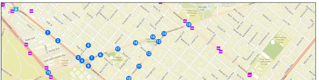
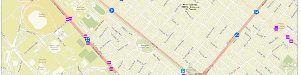
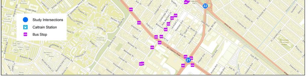
22 Study Intersections for Churchill Avenue Closure 22


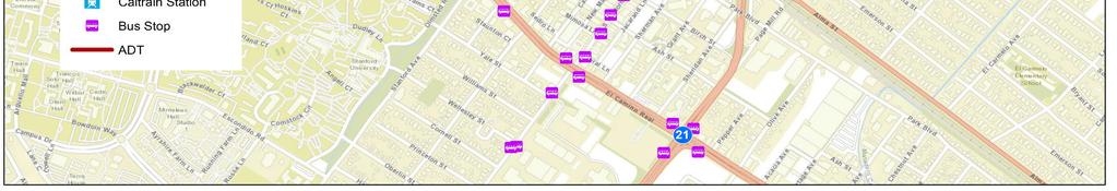
23 24-Hour Traffic Volumes Churchill Avenue Closure ADT = 24-Hour Bi-Directional Traffic Volumes 23
24 Existing Conditions Analysis Intersections Operating with Unacceptable Level of Service (LOS) based on City Standards and Congestion Management Program (CMP): 1. Alma Street/Lincoln Avenue (all peak hours) 2. Alma Street/Embarcadero Road (all peak hours) 3. Alma Street/Kingsley Avenue (all peak hours) 4. Alma Street/Churchill Avenue (a.m. peak hour) 5. Embarcadero Road/Cowper Street (all peak hours) 6. El Camino Real/Churchill Avenue (p.m. peak hour) 7. Alma Street/Oregon Expressway WB Off Ramp (Oregon Ave) (all peak hours) 8. Alma Street/Oregon Expressway EB Off Ramp (all peak hours) 24
25 Study Intersections with Unacceptable LOS 25

26 Origin-Destination (O-D) Analysis 18 O-D zones were selected for analysis to determine where trips using the Churchill Avenue crossing are coming from/going to Streetlight Data platform was used to collect data from 2017 when schools in Palo Alto were in session A.M. period = 6 a.m. 10 a.m. P.M. period = 3 p.m. 7 p.m. 26
27 Origin-Destination (O-D) through Churchill Avenue AM Period Approximately 42% of captured trips originated from the following zones: Stanford Avenue, west of El Camino Real (16%) Embarcadero Road, east of Middlefield Road (15%) Waverly Street, north of Embarcadero Road (11%) Approximately 65% of captured trips are destined to the following zones: Embarcadero Road, east of Middlefield Road (36%) Page Mill Road, west of El Camino Real (15%) Alma Street, south of Oregon Expressway (14%) 27
28 Origin-Destination (O-D) through Churchill Avenue AM Period 28
29 Origin-Destination (O-D) through Churchill Avenue PM Period Approximately 37% of captured trips originated from the following zones: Alma Street, south of Oregon Expressway (13%) Embarcadero Road, east of Middlefield Road (12%) El Camino Real, north of Embarcadero Road (12%) Approximately 63% of captured trips destined to the following zones: Embarcadero Road, east of Middlefield Road (36%) Alma Street, south of Oregon Expressway (20%) Cowper Street, north of Embarcadero Road (7%) 29

30 Origin-Destination (O-D) through Churchill Avenue PM Period 30
31 Next Steps Project Future Demands using VTA/City of Palo Alto Travel Demand Model (in progress) Project Diversion in Traffic based on Travel Demand Model Evaluate: Existing Conditions with Alternatives (with Churchill closure) Future Conditions Future Conditions with Alternatives (with Churchill closure) Develop Recommendations 31


32 Summary of Action Items/Next Meeting March 13, :00-6:00pm Materials from this meeting will be posted to: E-blast of March meeting notice will be sent to the CAP at the end of February for outreach purposes. 32

33 Thank you
25 th Avenue Grade Separation. September 13, 2017
 25 th Avenue Grade Separation September 13, 2017 Agenda I. Overview II. III. IV. Project Description Project Benefits Project Construction V. Next Steps VI. Questions 2 Overview Project Location 4 E. 25
25 th Avenue Grade Separation. December 13, 2017
 25 th Avenue Grade Separation December 13, 2017 Agenda I. Overview II. III. IV. Project Description Project Benefits Project Construction V. Next Steps VI. Questions 2 Overview Project Location 4 E. 25
Route 141 and I-44 Design-Build Project Community Involvement Group. March 21, 2016
 Route 141 and I-44 Design-Build Project Community Involvement Group March 21, 2016 Purpose of CIG 1. Share information with major stakeholders 2. Keep stakeholders informed of the process 3. Reduce uncertainty
SCOPING INFORMATION PACKET
 SCOPING INFORMATION PACKET Project Description The proposed project would provide a direct link connecting several light rail lines in operation or in construction, including the Metro Gold Line to Pasadena,
35 Downtown Mountain View to Stanford Shopping Center Effective Date 10/9/2017 Route Map
 35 Downtown Mountain View to Stanford Shopping Center Effective Date 10/9/2017 Route Map Northbound Weekday 6:28A 6:37A 6:46A 6:51A 6:55A 7:03A -- 6:59A 7:09A 7:18A 7:23A 7:28A 7:39A 7:46A 7:30A 7:40A
SR 934 Project Development And Environment (PD&E) Study
 Study") SR 934 Project Development And Environment (PD&E) Study Project Advisory Group Meeting March 1, 2018 State Road 934/NE/NW 79th Street from west of I-95 (NW 13th CT) to N. Bayshore Drive PD&E STUDY SR 934/NE/NW
SR 934 Project Development And Environment (PD&E) Study Project Advisory Group Meeting March 1, 2018 State Road 934/NE/NW 79th Street from west of I-95 (NW 13th CT) to N. Bayshore Drive PD&E STUDY SR 934/NE/NW
PRESENTED TO Town of Middlebury, VT. PRESENTED BY VTrans, VHB, Fitzgerald & Halliday, Inc., and Kubricky Construction
 PRESENTED TO Town of Middlebury, VT PRESENTED BY VTrans, VHB, Fitzgerald & Halliday, Inc., and Kubricky Construction Meeting with you today Brian Carpenter, Middlebury Selectboard Chair Jim Gish, Middlebury
Cell: (408) Release MA June 25, 2012
 Release MA June 25, 2012") VTA NEWS CONTACT: Bernice Alaniz FOR IMMEDIATE RELEASE Cell: (408) 888-9983 Release MA 12 06 08 Bernice.Alaniz@vta.org June 25, 2012 Construction Activities Underway For BART Silicon Valley The Santa Clara
VTA NEWS CONTACT: Bernice Alaniz FOR IMMEDIATE RELEASE Cell: (408) 888-9983 Release MA 12 06 08 Bernice.Alaniz@vta.org June 25, 2012 Construction Activities Underway For BART Silicon Valley The Santa Clara
Crystal City Station Improvements. Project Overview. Table 2: North Entrance. Table 1: South Entrance. 20th St. S 18th St. S.
 Table 1: South Entrance Table 2: North Entrance 20th St. S 18th St. S Proposed Second Entrance Crystal Drive Existing Station Location Platform Future 4 th Track Future New Airport Connection (by others)
This section evaluates the projected traffic operations and circulation impacts associated with the proposed upgrade and expansion of the LWRP.
 4.5 TRAFFIC AND CIRCULATION This section evaluates the projected traffic operations and circulation impacts associated with the proposed upgrade and expansion of the LWRP. 4.5.1 Environmental Setting Existing
G Street Undercrossing. City Council Meeting Date: November 3, 2008
 G Street Undercrossing City Council Meeting Date: November 3, 2008 Introduction G Street undercrossing Long-term goal of the City In General Plan since 1997 In City s Public Facilities Financing Plan
NEWS RELEASE. EL PASO DISTRICT Jennifer Wright (915) a TxDOT Project For immediate release.
 a TxDOT Project For immediate release.") NEWS RELEASE a TxDOT Project For immediate release EL PASO DISTRICT Jennifer Wright (915) 790-4340 Jennifer.Wright3@txdot.gov January 18, 2017 Mesa Continuous for 6 weeks The following closures started
NEWS RELEASE a TxDOT Project For immediate release EL PASO DISTRICT Jennifer Wright (915) 790-4340 Jennifer.Wright3@txdot.gov January 18, 2017 Mesa Continuous for 6 weeks The following closures started
Boston Redevelopment Authority 2/26/ Chestnut Hill Avenue Boston/Brookline, MA
 Boston Redevelopment Authority 2/26/2014 Cassidy Playground Waterworks Design revisions made since the DPIR submission March 2013 Massing - Reduced project 16,030 SF, for a total project area of 218,520
Transportation Demand Management Plan for the Proposed Hampton Inn & Suites in San Mateo, California
 Memorandum Date: October 3, 207 To: From: Subject: Tricia Schimpp, City of San Mateo Gary Black Ricky Williams Transportation Demand Management Plan for the Proposed Hampton Inn & Suites in San Mateo,
Project Deliverable 4.1.3d Individual City Report - City of La Verne
 Pomona Valley ITS Project Project Deliverable 4.1.3d Individual City Report - City of La Verne Prepared by: April 19, 2002 099017000.1 Copyright 2002, Kimley-Horn and Associates, Inc TABLE OF CONTENTS
BUILD. In this issue: NEW AERIALS OF CONSTRUCTION NEW PROJECT IN CONSTRUCTION PAC K AG E 4. August 2018
 BUILD C O N ST R U C T I O N Update August 2018 In this issue: NEW AERIALS OF CONSTRUCTION NEW PROJECT IN CONSTRUCTION PAC K AG E 4 AVENUE 12 CEDAR VIADUCT A VIEW FROM ROAD 27 ABOVE HSR CONSTRUCTION FRESNO
NEWS RELEASE. EL PASO DISTRICT Jennifer Wright (915) a TxDOT Project For immediate release
 a TxDOT Project For immediate release") NEWS RELEASE a TxDOT Project For immediate release EL PASO DISTRICT Jennifer Wright (915) 790-4340 Jennifer.Wright3@txdot.gov Major Operation: 36 massive beams will be placed at Sunland & I 10. Operation
NEWS RELEASE a TxDOT Project For immediate release EL PASO DISTRICT Jennifer Wright (915) 790-4340 Jennifer.Wright3@txdot.gov Major Operation: 36 massive beams will be placed at Sunland & I 10. Operation
Preliminary Flight Data Analysis (Lee A. Christel, Ph.D, Aug 19, 2015)
") Purpose Palo Alto residents have noticed a dramatic increase in the amount of air traffic and associated noise over the city. It is suspected that Palo Alto has been unfairly burdened with increases that
Purpose Palo Alto residents have noticed a dramatic increase in the amount of air traffic and associated noise over the city. It is suspected that Palo Alto has been unfairly burdened with increases that
Building Level Planning Committee March 30, 2016
 Arlington Public Schools Wilson School Site Evaluation Traffic Analysis and Pick-up/Drop-off location Building Level Planning Committee March 30, 2016 1 SAN ANTONIO-BEXAR COUNTY PEDESTRIAN SAFETY ACTION
Lake Erie Commerce Center Traffic Analysis
 LOCATION: East of NYS Route 5 at Bayview Road Town of Hamburg Erie County, New York PREPARED BY: Wendel Companies 140 John James Audubon Parkway Suite 200 Amherst, New York 14228 January 2012 i ii Table
Union Station Queens Quay Transit Link Study
 Welcome Union Station in 1899. Image: City of Toronto Archives Union Station today. Image: Camil Rosiak Activity along Queens Quay. Image: Waterfront Toronto For more information or to comment, visit toronto.ca/waterfronttransit
LESLIE BARNS & CONNECTION TRACK. Project Update Construction and Traffic Management Consultation
 LESLIE BARNS & CONNECTION TRACK Project Update Construction and Traffic Management Consultation PRESENTATION SUMMARY Part 1 Brief Project Update (New Streetcars & Streetscape Improvements) Part 2 Construction
Appendix B Connecting Track Options Evaluation Criteria
 Appendix B Connecting Track Options Evaluation Criteria 608979-853_ra_July5-0_App Title Pages.Docx TTC ASHBRIDGES BAY MAINTENANCE AND STORAGE FACILITY CONNECTING TRACK ROUTE ALTERNATIVE - EVAULATION MATRIX.0
South Bay Metro Light Rail Extension. Summer/Fall 2017 Project Briefings
 South Bay Metro Light Rail Extension Summer/Fall 2017 Project Briefings Meeting Agenda 2 Project History Project Development Schedule Feedback 3 Project History Alternatives Analysis Measure R $272M 2008
MEMORANDUM. Bob Zagozda, Chief Financial Officer Westside Community Schools. Mark Meisinger, PE, PTOE Felsburg Holt & Ullevig. DATE: June 11, 2018
 MEMORANDUM TO: Bob Zagozda, Chief Financial Officer Westside Community Schools FROM: Mark Meisinger, PE, PTOE Felsburg Holt & Ullevig DATE: June 11, 218 6-11-18 SUBJECT: Sunset Hills Elementary School
LUDWIG RD. SUBDIVISION PROJECT TRAFFIC IMPACT ANALYSIS
 LUDWIG RD. SUBDIVISION PROJECT TRAFFIC IMPACT ANALYSIS Prepared for Skip Coddington GSC Development, Inc PO Box 1623 Woodinville WA 9872 Prepared by 1141 NE 124 th St., #59 Kirkland, WA 9834 425.522.4118
San Mateo County Transportation Authority Board Meeting November 2, 2017 Item #10 1
 San Mateo County Transportation Authority Board Meeting November 2, 2017 Item #10 1 OVERVIEW Brief recap from October Traffic Analysis Findings Draft Environmental Document Summarized Outcomes Questions
Route 29 Solutions Projects
 Your guide to the Route 29 Solutions Projects For full details & continued engagement please visit www.route29solutions.org The Route 29 Solutions Package is a $230 million investment into the improvement
South Bay Light Rail Extension Summer/Fall 2017 Project Briefing
 South Bay Light Rail Extension Summer/Fall 2017 Project Briefing Meeting Agenda 2 Project History Project Development Schedule Feedback Study Area Project History 4 Alternatives Analysis 2008 Measure R
Interstate 90 and Mercer Island Mobility Study APRIL Commissioned by. Prepared by
 Interstate 90 and Mercer Island Mobility Study APRIL 2017 Commissioned by Prepared by Interstate 90 and Mercer Island Mobility Study Commissioned by: Sound Transit Prepared by: April 2017 Contents Section
AGENDA ITEM I-6 Public Works
 AGENDA ITEM I-6 Public Works STAFF REPORT City Council Meeting Date: 8/6/2018 Staff Report Number: 18-150-CC Informational Item: Update on the Willow Road and highway 101 interchange construction, upcoming
SANTA CLARA COUNTY I-280 CORRIDOR STUDY
 SANTA CLARA COUNTY I-280 CORRIDOR STUDY Appendix B 2 Technical Memorandum Existing Transportation Condition Memo SANTA CLARA VALLEY TRANSPORTATION AUTHORITY (VTA) 1-1 Introduction The I-280 Corridor Study
Overview of Highway 37 Project. Napa County Board of Supervisors December 20, 2016
 Overview of Highway 37 Project Napa County Board of Supervisors December 20, 2016 1 Project Location-Caltrans District 4 2 SR 37 Corridor Features 2 to 4 lane 21 mile corridor traversing Solano, Sonoma,
1.2 Corridor History and Current Characteristics
 SECTION 1 Description and Background of Study Area 1.1 Introduction This preliminary engineering report was prepared for the Alaska Department of Transportation and Public Facilities (ADOT&PF). It is part
East of the Rideau Transit Forum
 East of the Rideau Transit Forum Transportation Services Department June 6, 2017 0 What s Coming in 2018 O-Train Network 1 1 O-Train Confederation Line Multi-Modal Transformation The O-Train Confederation
East Link Project Update. Maintenance of Traffic During Construction. April 21, 2015
 East Link Project Update Maintenance of Traffic During Construction April 21, 2015 1 Agenda TFP project 242 Bellevue Way HOV Bellevue Way - Maintenance of Traffic During Construction Early Work Utilities
TECHNICAL MEMORANDUM. DATE: August 31, Pamela Dalcin-Walling/Dokken Engineering. Daniel Yau and Victor Baltazar/Y&C
 DATE: August 31, 2017 TECHICAL MEMORADUM Y&C Transportation Consultants, Inc. 3250 Ramos Circle Sacramento, CA 95827 Phone: (916) 366-8000 Fax (916) 366-8008 TO: FROM: SUBJECT: Pamela Dalcin-Walling/Dokken
Hospital Link Project Project Update Winter 2018
 Hospital Link Project Project Update Winter 2018 General The project provides a link from Riverside Drive and the Transitway to the Hospital Link Road. Construction of the Hospital Link facility is open
Traffic Analysis Final Report
 SR-71 Widening Project Project Approval/Environmental Documentation Traffic Analysis Final Report Prepared for Caltrans District 7 August 2012 6 Hutton Centre Drive, Suite 700 Santa Ana, California 92707
Longmont to Boulder Regional Trail Jay Road Connection DRAFT FINAL REPORT
 Longmont to Boulder Regional Trail Jay Road Connection DRAFT FINAL REPORT December 2018 Project Summary Boulder County, Colorado, in partnership with the City of Boulder, is evaluating options for multi-use
MPRB: Southwest LRT Community Advisory Committee Issues and Outcomes by Location Current to: 12 November 2010
 MPRB: Southwest LRT Community Advisory Committee Issues and Outcomes by Location Current to: 12 November 2010 This is a compilation of issues and outcomes identified by the CAC. It is a work in progress,
Becker County Trail Routing Feasibility Study
 2016 Becker County Trail Routing Feasibility Study CONNECTING DETROIT MOUNTAIN AND MOUNTAIN VIEW RECREATIONAL AREA TO THE HEARTLAND TRAIL BECKER COUNTY ULTEIG ENGINEERS Contents Acknowledgements...2 INTRODUCTION...3
Pedestrian Safety Review Spadina Avenue
 STAFF REPORT ACTION REQUIRED Pedestrian Safety Review Spadina Avenue Date: October 13, 2015 To: Toronto and East York Community Council From: Director, Transportation Services, Toronto and East York District
Innerbelt Bridge Contract Group 2 Tremont / Towpath Trail and Gateway January 8, 2013
 Innerbelt Bridge Contract Group 2 Tremont / Towpath Trail and Gateway January 8, 2013 Cleveland Innerbelt Construction Schedule former schedule 2011 Winter Begin Construction Innerbelt CCG1 (WB Bridge)
South Bay Metro Green Line Extension
 South Bay Metro Green Line Extension Spring 2011 Community Meetings 1 2 Agenda Introduction Where We ve Been Project Status What s Next Discussion 3 Where We ve Been Scoping Meetings April/May 2010 4 Meetings
Metro ExpressLanes April 5, 2011 Community Meeting re: Adams Blvd Improvements
 Metro ExpressLanes April 5, 2011 Community Meeting re: Adams Blvd Improvements Jan Perry Councilwoman, District 9 Welcome Remarks Arthur T. Leahy Chief Executive Officer, Metro Metro ExpressLanes Overview
BALLAST CLEANING TO IMPROVE DRAINAGE IN METROLINK S VALLEY SUBDIVISION TUNNEL 25
 Number of Words: 3,527 ABSTRACT BALLAST CLEANING TO IMPROVE DRAINAGE IN METROLINK S VALLEY SUBDIVISION TUNNEL 25 Tim Harris Track Maintenance Engineer 2704 North Garey Ave. Pomona, CA 91767 213/494-1215
PRIORITIES COMMITTEE MEETING
 PRIORITIES COMMITTEE MEETING Meeting Date: 05/13/14 Agenda Item #: 13.1 Northeast Anthony Henday Drive Update Report Purpose To update the Priorities Committee on the progress of the Northeast Anthony
Better rail journeys arriving in May 2018 The Great North Rail Project between Preston and Blackpool 1 December 2017
 Better rail journeys arriving in May 2018 The Great North Rail Project between Preston and Blackpool 1 December 2017 Transforming the railway a week in pictures Three weeks into our extended Preston to
Construction Staging Adelaide Street West
 REPORT FOR ACTION Construction Staging Adelaide Street West Date: October 6, 2016 To: Toronto and East York Community Council From: Acting Director, Transportation Services, Toronto and East York District
Damen Elston Fullerton Reconstruction, Intersection Improvements CDOT Project B-1-501
 Damen Elston Fullerton Reconstruction, Intersection Improvements CDOT Project B-1-501 Bird s Eye View of Existing INTRODUCTION This project is part of the City s Building a New Chicago initiative in conjunction
VRE Manassas Park Station Parking Expansion Alternatives Analysis
 VRE Manassas Park Station Parking Expansion Alternatives Analysis Summary Report September 18, 2017 THIS PAGE INTENTIONALLY LEFT BLANK Table of Contents 1.0 Introduction... 1 2.0 Summary of Existing Conditions...3
Site Location and Setting
 Memorandum Date: To: From: Subject: Kristy Le, Gary Black Steve Orem Santa Teresa County Park Historic Area Traffic and Parking Study Hexagon Transportation Consultants, Inc. has completed a traffic and
Figure 1: Little Dry Creek Trail Crossing
 Figure 1: Little Dry Creek Trail Crossing Figure 2: Little Dry Creek Trail Crossing Northwest Rail Environmental Evaluation Temporary Trail Detour Concurrence Form Adams County, Little Dry Creek Trail
Major Projects Overview
 Major Projects Overview Miami-Dade Expressway Authority February 2018 About MDX MDX operates 5 roads in Miami Dade County SR 924, SR 112, SR 836, SR 874 and SR 878 MDX Primary Source of Revenue: User Fees-Tolls
145th Crossing Sammamish River Trail Connection Tourism District Pedestrian Enhancement. ~ King County PIBBI. YourBigBa~
 145th Crossing Sammamish River Trail Connection Tourism District Pedestrian Enhancement ~ King County PIBBI YourBigBa~ The Trail & the Tourism District Growing pedestrian traffic between tourism destinations
APPENDIX J TRAFFIC AND PARKING DEMAND STUDIES
 APPENDIX J TRAFFIC AND PARKING DEMAND STUDIES Table of Contents Executive Summary... iv 1.0 Introduction... 1 2.0 Traffic Analysis Methodology and Significance Criteria... 4 2.1 Study Area Criteria...
Transportation TRANSPORTATION PROJECTS
 Transportation TRANSPORTATION PROJECTS Balls Ford Road Interchange Total Project Cost $142.9M This project includes the construction of a new diverging diamond interchange at Route 234 Bypass (Prince William
Update on the I-680 Transit Corridor Improvement Project HOV on/off Ramps Environmental Impact Report Community Engagement Plan
 Update on the I-680 Transit Corridor Improvement Project HOV on/off Ramps Environmental Impact Report Community Engagement Plan Presentation Overview Introductions Susan Miller, Director of Projects, Contra
5.1 Traffic and Transportation
 5.1 When it opens in 2009, the Bellevue Nickel Improvement Project will increase the number of vehicles able to travel through the study area, improve travel speeds, and improve safety by reducing the
Section 4(f) and Section 6(f) Technical Analysis
 and Section 6(f) Technical Analysis") WESTSIDE SUBWAY EXTENSION PROJECT Contract No. PS-4350-2000 Section 4(f) and Section 6(f) Technical Analysis Prepared for: Prepared by: WSP USA 851 SW Sixth Avenue, Suite 1600 Portland, Oregon 97204 FEBRUARY
WESTSIDE SUBWAY EXTENSION PROJECT Contract No. PS-4350-2000 Section 4(f) and Section 6(f) Technical Analysis Prepared for: Prepared by: WSP USA 851 SW Sixth Avenue, Suite 1600 Portland, Oregon 97204 FEBRUARY
2016 Regional Transportation Alternatives Program (TAP) Grant Application
 Grant Application") 2016 Regional Transportation Alternatives Program (TAP) Grant Application PROJECT TITLE: Yelm-Tenino Trail Extension Feasibility Study TRPC use only GENERAL PROJECT INFORMATION Agency or Organization City
2016 Regional Transportation Alternatives Program (TAP) Grant Application PROJECT TITLE: Yelm-Tenino Trail Extension Feasibility Study TRPC use only GENERAL PROJECT INFORMATION Agency or Organization City
EXTERNAL COMMUNICATIONS TEAM MEETING MARCH 2015
 EXTERNAL COMMUNICATIONS TEAM MEETING MARCH 2015 1 SEGMENT 1 2 THE WISHBONE Connects the TEXpress Managed Toll System to the 35Express Managed Toll System Limits: Crown Road (near Royal Lane) to Valley
7272 WISCONSIN AVENUE LOCAL AREA TRANSPORTATION REVIEW
 7272 LOCAL AREA TRANSPORTATION REVIEW AND TRANSPORTATION POLICY AREA REVIEW MONTGOMERY COUNTY, MARYLAND Submitted on behalf of Carr Properties Prepared by: Wells + Associates, Inc. Submission: July 1,
November 21, 2012 Barbara Kelleher, (954)
") November 21, 2012 Barbara Kelleher, (954) 777-4090 barbara.kelleher@dot.state.fl.us BROWARD COUNTY TRAFFIC IMPACT REPORT November 26 to November 30, 2012 FORT LAUDERDALE -- Construction and maintenance-related
November 21, 2012 Barbara Kelleher, (954) 777-4090 barbara.kelleher@dot.state.fl.us BROWARD COUNTY TRAFFIC IMPACT REPORT November 26 to November 30, 2012 FORT LAUDERDALE -- Construction and maintenance-related
Executive Summary. See Figure ES-5 on page 9. Figure ES-6: Typical At-Grade Alignment. Figure ES-7: Typical Underground Alignment
 Figure ES-5 shows all of the possible LRT routes and stations identified for study in the Draft EIS/EIR. The features and impacts of each of the build alternatives are described in the following section.
The 710 Tunnel Threatens Pasadena. March, 2013
 The 710 Tunnel Threatens Pasadena March, 2013 Metro Route 710 Study Metro Route 710 Study Metro Study Alternatives Bus Rapid Transit (BRT-6) Light Rail (LRT-4) Metro Study Alternatives Bus Service Transportation
US 19 Sunset Point Rd to Countryside Blvd.
 Frontage Lanes Alternative Six-Lane Roadway Two-Lane, One-Way Frontage Lanes Close All Median Openings w/ Concrete Median Barrier Construct Within Existing Right-of-Way Status Update Construction started
25 th Avenue Grade Separation. Community Meeting November 13, 2018
 25 th Avenue Grade Separation Community Meeting November 13, 2018 Agenda I. Project Need II. Project Benefits III. Project Description IV. Funding V. Schedule VI. Construction VII. Next Steps 2 Project
UNION STATION ACCESS AND CAPACITY IMPROVEMENT STUDY PROJECT REPORT
 UNION STATION ACCESS AND CAPACITY IMPROVEMENT STUDY PROJECT REPORT Washington Metropolitan Area Transit Authority Department of Planning and Joint Development In Association with District of Columbia Department
Design Meeting Presentation
 Contract No. 17ECS-TI-05SP April November 2017 Design Meeting Presentation November 2015 Agenda Items: Introduction (5 min) Overview (10 min) Scope of work (60 min): Schedule and Traffic Staging / Closures
Eglinton-Scarborough Crosstown LRT Update
 Eglinton-Scarborough Crosstown LRT Update Councillor Matlow and Councillor Stintz Town Hall February 28 2012 Presented by: Anna Pace, Director Strategic Partnerships, TTC Transit Expansion Department 2/28/2012
FY Transportation Improvement Program Funding Summary: Local Match for Federal Funds
 CMAQ-Flex AMPA Wide Bicycle Facil. Prog. & Activities 100.5 A300705 City of $25,562 $25,562 AMPA Wide Bicycle Facil. Prog. & Activities 100.6 A300706 City of $25,562 $25,562 AMPA Wide Joint TDM-Travel
Progress Report for Projects of Regional Significance
 Rosedale Highway facing west January 2017 What s Inside? Kern Council of Governments Progress Report for Projects of Regional Significance EDITION Status Information on: Safety & Maintenance...this section
Auburn Trail / Ontario Pathways Trail Connector Feasibility Study Public Information Meeting Wednesday, August 22, 2012
 Auburn Trail / Ontario Pathways Trail Connector Feasibility Study Public Information Meeting Wednesday, August 22, 2012 Purpose of Feasibility Study Purpose Evaluate the feasibility of constructing a multiuse
Designing & Building for People on Bikes within evolving constraints Auckland Central City
 Designing & Building for People on Bikes within evolving constraints Auckland Central City Asia Pacific Cycle Congress 19 October 2017 Graeme Bean MEngSc (Transport), BE (Civil), PGDipBus (Mktg), MEngNZ,
Palm Beach County Traffic Report July 13 through July 20, 2012
 For Immediate Release July 13, 2012 Meredith Cruz, (561) 641-6440 mcruz@corradino.com Palm Beach County Traffic Report July 13 through July 20, 2012 Palm Beach County Palm Beach County traffic will be
RW Bruhn Bridge and Approaches Project
 RW Bruhn Bridge and Approaches Project The Trans-Canada Highway 1 RW Bruhn Bridge and Approaches Project involves four-laning approximately 1.9 km of Highway 1 in Sicamous, including replacement of the
Trail # NW Tuesday, June DESIGN. Provide an Review the Provide an. Project Goals: System system. wayfinding
 I. Welcome / Introductions Bethany Creek Trail #2 Segment 3 Neighborhood Meeting #1 Bethany Presbyterian Church 15505 NW Springville Road, Portland, OR 97229 Tuesday, June 26, 2018 @ 6:00PM Meeting Minutes
Portland - Milwaukie Light Rail Willamette River Bridge
 Willamette River Transit Bridge Portland - Milwaukie Light Rail Willamette River Bridge Design Workshop kh 07.02.09 Proposed Bridge Alignment Willamette River Transit Bridge Marquam Ross Island Cable Stayed
I-579 Urban Open Space CAP Project. Final Land Development Plan (FLDP) Pittsburgh Department of City Planning
 Pittsburgh Department of City Planning") Final Land Development Plan (FLDP) I-579 Urban Open Space CAP Project Sports & Exhibition Authority (SEA) of the City of Pittsburgh and Allegheny County Project bounded by Chatham St. / Centre Ave. / Washington
Final Land Development Plan (FLDP) I-579 Urban Open Space CAP Project Sports & Exhibition Authority (SEA) of the City of Pittsburgh and Allegheny County Project bounded by Chatham St. / Centre Ave. / Washington
395 Express Lanes Major Closure Advisory
 395 Express Lanes Major Closure Advisory 3-Week Schedule Lane Closure And Construction Activities Week of February 26 th 1) Highway/Name & Route #: Braddock Road Bridge Lane/Shoulder Closure: Single Lane
Macleod Trail Corridor Study. Welcome. Macleod Trail Corridor Study Open House. Presentation of Proposed Design Concepts
 Macleod Trail Corridor Study Welcome Macleod Trail Corridor Study Open House Presentation of Proposed Design Concepts Study Purpose Develop a corridor plan for Macleod Trail that aligns with The City s:
Chicago St. Louis High-Speed Rail. Braidwood Construction. Local Officials Briefing August 7, 2014
 Chicago St. Louis High-Speed Rail Braidwood Construction Local Officials Briefing August 7, 2014 1 Chicago-St. Louis Corridor Goals and Benefits» Reduction in travel time by about an hour» Enhanced reliability»
HIGHWAY 17 WILDLIFE and REGIONAL TRAIL CROSSINGS
 HIGHWAY 17 WILDLIFE and REGIONAL TRAIL CROSSINGS Agenda and Meeting Format 7:00-7:15 Welcome 7:15-8:00 Presentation 8:00-8:30 Open House 8:30 Recap 9:00 Conclusion 2 Meeting Goals: Introduce the project
Grade Crossings in High Speed Rail Corridors
 Grade Crossings in High Speed Rail Corridors 59 th ANNUAL ILLINOIS TRAFFIC ENGINEERING & SAFETY CONFERENCE October 21, 2010 Champaign, IL Michael E. Stead Rail Safety Section Illinois Commerce Commission
Northeast Anthony Henday Drive Edmonton Ring Road Update. Strathcona Chamber of Commerce March 18, 2015
 Northeast Anthony Henday Drive Edmonton Ring Road Update Strathcona Chamber of Commerce March 18, 2015 Project Background 2 Edmonton Ring Road Northwest opened Nov 2011 Northeast to open Oct 2016 Southwest
Transportation Improvement District (TID) Exercise New Castle County Unified Development Code
 Exercise New Castle County Unified Development Code") Transportation Improvement District (TID) Exercise New Castle County Unified Development Code Churchmans Crossing TID How should New Castle County deploy Transportation Improvement Districts (TIDs)? Site
Transportation Improvement District (TID) Exercise New Castle County Unified Development Code Churchmans Crossing TID How should New Castle County deploy Transportation Improvement Districts (TIDs)? Site
Long water shutdown scheduled for Tuesday, September 18
 Thank you for your interest in the Center City Connector Streetcar. In this weekly update, you ll find information about ongoing construction for the 1st phase of utility work in Pioneer Square. Utility
State Route 8 Corridor. Northern Summit County s Path to Success
 State Route 8 Corridor Northern Summit County s Path to Success Construction Guide: 2008-2009 State Route 8 corridor work description State Route 8 Corridor 10 projects $262 million With its close proximity
RAILROAD QUIET ZONE PROJECT
 RAILROAD QUIET ZONE PROJECT VILLAGE OF ROSELLE Village of Roselle 31 S. Prospect Street Roselle, IL 60172 9575 WEST HIGGINS ROAD, SUITE 600 ROSEMONT, IL 60018 TEL. (847) 823-0500 FAX (847) 823-0520 Table
Playa Vista Ability2Change Webinar
 Playa Vista Ability2Change Webinar Aaron Gaul Director UrbanTrans North America Hi, I m Aaron. I m a transportation nerd. 1 PROJECT CONTEXT Playa Vista Community Overview 5,100+ employees 49% growth in
Southern Oregon Transportation Engineering, LLC
 Southern Oregon Transportation Engineering, LLC 112 Monterey Drive - Medford, Or. 97504 Office 541.608.9923 Cell 541.941.4148 Email: Kwkp1@Q.com August 12, 2013 Mike Faught, Public Works Department City
Sacramento Placerville Transportation Corridor Alternatives Analysis
 Sacramento Placerville Transportation Corridor Alternatives Analysis EL DORADO COUNTY TRANSPORTATION COMMISSION 1 Sacramento Placerville Transportation Corridor 2 Goal of the Project To give public officials
Introduction. Project Overview
 Washington Blvd./Andora Widening Project Community Open House & Public Scoping Meeting Summary Wednesday, September 21, 2016 6:00 7:30 p.m. Vencil Brown Elementary School, Roseville Introduction On Wednesday,
Carlisle Connectivity Projects Communication Plan and Project Status
 Carlisle Connectivity Projects Communication Plan and Project Status Overview Communication Plan Communication Plan Communication Plan Objective The Borough staff will develop and execute timely and effective
Welcome to Palo Alto, California
 Welcome to Palo Alto, California Photo courtesy of Finlay McWalter. Courtesy Map for the EPRI Palo Alto Office 3420 Hillview Avenue Palo Alto, California 4304 800.313.3774 Palo Alto Area Hotels 1 Creekside
MIRANDA AVENUE PALO ALTO, CALIFORNIA HUDSONPACIFICPROPERTIES.COM
 001-015 MIRANDA AVENUE PALO ALTO, CALIFORNIA HUDSONPACIFICPROPERTIES.COM SERENE & CONVENIENT FEATURES AND AMENITIES TWO-STORY BUILDINGS STANFORD RESEARCH PARK LOCATION 195,386 TOTAL SQUARE FEET CAMPUS
A. CONCLUSIONS OF THE FGEIS
 Chapter 11: Traffic and Parking A. CONCLUSIONS OF THE FGEIS The FGEIS found that the Approved Plan will generate a substantial volume of vehicular and pedestrian activity, including an estimated 1,300
We lc o m e to Palo Alto, California
 We lc o m e to Palo Alto, California Photo courtesy of Finlay McWalter. Courtesy Map for the EPRI Palo Alto Office 3420 Hillview Avenue Palo Alto, California 4304 800.313.3774 Palo Alto Area Hotels 1 Creekside