Sunshine Coast Council
|
|
|
- Jessica Jordan
- 6 years ago
- Views:
Transcription


1 Sunshine Coast Council Sunshine Coast Council area Population and Household Forecasts 2016 to 2026 population forecast 1
2 Table of contents Home 3 About the forecast areas 4 Drivers of population change 5 Population summary 8 Population, households and dwellings 10 Components of population change 12 Population and age structure 14 Household types 16 Dwellings and development 19 Population and age structure 22 Household types 56 Residential development 68 Net migration by age 71 Non-private dwellings 72 Births and deaths 74 About the forecasts 75 Factors of population change 76 Household and suburb life cycles 78 Forecast modelling process 81 Notes on base data 85 Glossary 86 2


3 Welcome to Sunshine Coast Council area population forecasts The Sunshine Coast Council area Population and Household Forecasts present what is driving population change in the community and how the population, age structure and household types will change each year between 2016 and The forecasts are designed to provide community groups, Council, investors, business, students and the general public with the knowledge to make confident decisions about the future. These forecasts were last updated in October 2017 by.id, the population experts, on behalf of Sunshine Coast Council. Forecasts are available for each year from 2016 to Important Population 2016 Population 2026 Change Statistics 303, , % Forecast population 3

4 About the forecast areas The Sunshine Coast Council area includes the suburbs, townships and rural localities of Alexandra Headland, Aroona, Bald Knob, Balmoral Ridge, Battery Hill, Beerburrum, Beerwah, Belli Park, Bells Creek, Birtinya, Bli Bli, Bokarina, Booroobin, Bribie Island North, Bridges, Buddina, Buderim, Burnside, Caloundra, Caloundra West, Cambroon, Chevallum, Coes Creek, Conondale, Coochin Creek, Coolabine, Cooloolabin, Coolum Beach, Crohamhurst, Curramore, Currimundi, Diamond Valley, Dicky Beach, Diddillibah, Doonan (part), Dulong, Eerwah Vale, Elaman Creek, Eudlo, Eumundi, Flaxton, Forest Glen, Gheerulla, Glass House Mountains, Glenview, Golden Beach, Highworth, Hunchy, Ilkley, Image Flat, Kenilworth, Kiamba, Kidaman Creek, Kiels Mountain, Kings Beach, Kulangoor, Kuluin, Kunda Park, Kureelpa, Landers Shoot, Landsborough, Little Mountain, Maleny, Mapleton, Marcoola, Maroochy River, Maroochydore, Meridan Plains, Minyama, Moffat Beach, Mons, Montville, Mooloolaba, Mooloolah Valley, Mount Coolum, Mount Mellum, Mountain Creek, Mudjimba, Nambour, Ninderry, North Arm, North Maleny, Obi Obi, Pacific Paradise, Palmview, Palmwoods, Parklands, Parrearra, Peachester, Pelican Waters, Peregian Beach (part), Peregian Springs, Perwillowen, Point Arkwright, Reesville, Rosemount, Shelly Beach, Sippy Downs, Tanawha, Towen Mountain, Twin Waters, Valdora, Verrierdale, Warana, West Woombye, Weyba Downs, Witta, Woombye, Wootha, Wurtulla, Yandina, Yandina Creek and Yaroomba. Forecast areas Sunshine Coast Council area Source: Population and household forecasts, 2016 to 2026, prepared by.id the population experts, October
5 Drivers of population change Development History The Sunshine Coast Council area is a rapidly growing residential and tourist area located in south-east Queensland, about 100 kilometres north of Brisbane. It encompasses a total land area of about 2,200 square kilometres, including significant beaches, coastline, waterways, national parks, state forests and bushland. The area is diverse in terms of its land use and economic base with a mixture of urban areas, resort towns, tourist developments, inland towns, rural land and parkland. Tourism is a major industry with many resorts and holiday accommodation located along the coast. Much of the rural area is used for dairy farming, cattle grazing and crop growing. Although European settlement of the Sunshine Coast dates back to 1850s, significant development did not occur until the post-war years, as the area began to develop into a centre for tourism. Rapid growth took place particularly from the late 1960s when the population of the Council area increased from about 21,000 in 1947 to about 36,000 in The population has continued to increase rapidly, rising to nearly 137,000 in 1991, to about 200,000 in 2001, and then to over 267,000 in 2011, becoming one of the fastest growing Council areas in Australia. The Sunshine Coast has several significant urban hubs, concentrated predominantly on the coast at Caloundra, Kawana Waters and Maroochydore; whilst inland centres such as Nambour, Maleny and, increasingly, Beerwah, have developed primarily as commercial centres for the hinterland Migration patterns The primary housing market role that the Sunshine Coast plays is varied: the coastal urban areas attract retirees from Brisbane and interstate (mainly New South Wales) and younger adults accessing employment (generally within tourism and the service economy); new developments along the coast (such as Pelican Waters and Peregian Springs) and established suburban areas (such as Buderim) tend to attract older families as well as empty-nesters; meanwhile, townships within the hinterland predominantly attract families and retirees from the wider rural region. The urban hubs of Maroochydore and Caloundra, and the University of the Sunshine Coast in Sippy Downs attract young people from rural areas, regional Queensland and overseas to educational and employment opportunities, while the Sunshine Coast Region as a whole loses young people to larger centres in Queensland such as Brisbane and interstate. The importance of the Sunshine Coast as a destination for families and retirees is expected to continue into the future, with migration mostly comprised of parents with young children attracted to new greenfield development areas and empty nesters and retirees attracted to coastal centres and, to a lesser degree, the rural hinterland around centres such as Maleny. These trends are driven by large new areas of housing and commercial development, particularly around Kawana Waters and the development of the Maroochydore City Centre, the ongoing development of Peregian Springs and significant greenfield opportunities in Palmview (Harmony) and Caloundra South (Aura). 5

6 Historical migration flows, Sunshine Coast Council area, Overseas' refers to arrivals only. Source: Population and household forecasts, 2016 to 2026, prepared by.id the population experts, October Note: The migration flows depicted above do not represent future or forecast migration flows. The arrows represent migration flows to the area as a whole and do not indicate an origin or destination for any specific localities within the area. Overseas flow shows overseas arrivals only, based on answers to the census question where did the person usually live 5-years ago. 6
7 Housing role and function With a variety of residential, tourism focussed and rural areas as well as the location and development of large institutions such as the Sunshine Coast Public University Hospital (opened 2016) and the University of the Sunshine Coast, different areas within the Sunshine Coast have developed different roles within the housing market. The urban beachside areas of Marcoola - Twin Waters - Pacific Paradise, Caloundra - Kings Beach - Moffat Beach - Shelly Beach, Maroochydore and Mooloolaba - Alexandra Headland are important retirement destinations as well as significant areas for tourism. Urban hubs such as Maroochydore, Caloundra - Kings Beach - Moffat Beach - Shelly Beach and Mooloolaba - Alexandra Headland have large amounts of tourist and rental accommodation attractive to retirees and young adults due to their location, relative ease of travelling to the university, employment opportunities and a large stock of medium and high density housing. Other beachside areas such as Golden Beach, Wurtulla - Buddina & District, Pelican Waters, and areas stretching away from the coast, such as Buderim - Kuluin - Mons - Kunda Park, have a more suburban aspect which, whilst attracting significant numbers of empty-nesters and retirees, have a large stock of detached housing that appeals to families with children. This is a similar pattern to that experienced in the rural centres of Nambour, Maleny, Beerwah and Landsborough, which attract retirees from the wider region (wanting to be close to services as needs change) and families. Other rural areas such as Mapleton - Flaxton - Obi Obi, Maleny - Witta - North Maleny, Glass House Mountains - Beerburrum - Coochin Creek - Bribie Island North and Yandina - Yandina Creek & District attract large numbers of empty-nesters owing to lifestyle choice and proximity to national parks. In contrast newly developed estates in Mountain Creek (Brightwater) and Little Mountain - Caloundra West - Meridan Plains - Bells Creek (Aura) attract predominantly young families with children aged 0-9 years and first-time homebuyers. Housing Supply There are also significant differences in the supply of residential property within the Sunshine Coast which will have a major influence on population and household outcomes over the forecast period. Significant greenfield opportunities have been identified in Palmwoods and Caloundra South that are expected to attract families with children and also provide affordable housing options for first-time home-buyers. Further residential development in Pelican Waters and Peregian Springs is likely to appeal to empty-nesters and retirees as well as established families who are second or third time homebuyers. The construction of Maroochydore s CBD (SunCentral) as a regional centre in an already established town is expected to influence the mix of housing and population in the immediate area. In the longer term, there are likely to be further greenfield opportunities identified within the hinterland in response to increasing longer term demand within South-East Queensland. There are also significant residential opportunities within other established urban areas, with the development of Oceanside at Kawana Waters likely to supply significant numbers of higher and medium density housing opportunities. These projects, together with the continuing development of the Sunshine Coast Public University Hospital, are expected to provide significant employment and economic opportunities for the Region, further stimulating housing demand. The continued development of the University can be expected to have a similar outcome in Sippy Downs, prompting further commercial and residential growth. There are also significant opportunities for greater densification of housing around Nicklin Way with the establishment of the proposed light-rail transport system and, overtime, is expected to add significantly to the dwelling stock. Beachside areas, such as Caloundra, Wurtulla, Maroochydore, Mooloolaba - Alexandra Headland and Coolum Beach are expected to have considerable numbers of apartments and units built on redevelopment sites for both tourism and retirement purposes, while older suburbs such as Buderim - Kuluin - Mons - Kunda Park and Sippy Downs are expected to have large rates of infill development due to the age and size of housing lots in the area. Finally, low density residential subdivision is expected to continue around townships throughout the period, collectively adding relatively significant numbers over the forecast period, attracting predominantly families with children and empty-nester households. 7
8 Population summary This table summarises the population for Sunshine Coast Council area and each of its small areas. This enables you to see how population change is affecting different parts of the LGA in different ways. Some small areas may be rapidly growing whilst others are stable or even declining in population. Please note that population numbers in forecast.id for the 2016 base year are derived from Estimated Resident Population from the Australian Bureau of Statistics. These differ from (and are usually higher than) Census counts as they factor in population missed by the Census and population overseas on Census night. They are generally considered a more accurate measure of population size than Census counts. Population summary Forecast year Change Area Number % Average annual change Sunshine Coast Council area 292, , ,839 76, Beerwah 6,328 7,749 8,882 2, Belli Park - Cooloolabin - Gheerulla - Coolabine - Kureelpa - Kiamba 2,318 2,326 2, Bli Bli - Rosemount & District 12,194 14,518 14,846 2, Buderim - Kuluin - Mons - Kunda Park 32,278 33,460 35,048 2, Caloundra - Kings Beach - Moffat Beach - Shelly Beach 9,866 10,535 11,659 1, Coolum Beach - Mount Coolum - Yaroomba - Point Arkwright 14,277 15,635 16,209 1, Currimundi - Aroona - Battery Hill - Dicky Beach 14,545 14,871 16,043 1, Eumundi - Eerwah Vale - North Arm - Bridges 3,524 3,611 3, Glass House Mountains - Beerburrum - Coochin Creek - Bribie Island North 5,824 6,375 7,119 1, Golden Beach 5,338 5,391 5, Ilkley - Eudlo & District 4,692 4,971 4, Landsborough - Mount Mellum 4,458 4,942 5,512 1, Little Mountain - Caloundra West - Meridan Plains - Bells Creek 20,350 27,117 37,236 16, Maleny - Witta - North Maleny 5,777 6,163 6, Mapleton - Flaxton - Obi Obi 2,507 2,728 3, Marcoola - Twin Waters - Pacific Paradise - Mudjimba 10,547 11,461 12,665 2, Maroochydore 16,404 20,495 23,369 6, Mooloolaba - Alexandra Headland 11,856 13,056 13,257 1, Mooloolah Valley - Diamond Valley - Balmoral Ridge - Bald Knob 4,414 4,585 4,
9 Forecast year Change Area Number % Average annual change Mountain Creek 15,010 16,421 16,548 1, Nambour - Burnside & District 17,069 19,131 21,839 4, Palmwoods - Chevallum - Montville - Hunchy 7,714 8,047 8, Peachester - Crohamhurst - Booroobin - Wootha 1,849 1,825 1, Pelican Waters 6,198 8,440 10,414 4, Peregian Springs 6,617 10,420 10,476 3, Reesville - Curramore & District 2,613 2,605 2, Sippy Downs - Palmview 10,777 13,245 20,052 9, Weyba Downs - Verrierdale - Doonan (part) 4,224 4,193 4, Woombye 3,185 3,751 4, Wurtulla - Buddina & District 23,259 26,303 27,439 4, Yandina - Yandina Creek & District 6,938 7,834 9,142 2,
10 Population, households and dwellings This summary shows the results of the forecasts for population, households and dwellings in Sunshine Coast Council area. The period 2016 to 2026, as the short to medium term, is likely to be the most accurate and useful forecast information for immediate planning purposes. It is important to look at the relationship between population and average household size. If the average household size is falling, then there will need to be growth in the number of households (and dwellings for them to live in) to maintain or grow the population. Forecast population, households and dwellings Sunshine Coast Council area Forecast year Summary Population 303, , ,839 Change in population (5yrs) 36,137 39,255 37,634 Average annual change Households 116, , ,672 Average household size Population in non-private dwellings 4,004 5,853 6,017 Dwellings 129, , ,250 Dwelling occupancy rate
. It is expected to increase by over 76,890 people to 369,839 by 2026, at an average annual growth rate of 2.39%.")
11 Forecast population, households and average household size Key findings In 2016, the total population of Sunshine Coast Council area was estimated to be 292,950 people (ABS Census figure is 303,389 people). It is expected to increase by over 76,890 people to 369,839 by 2026, at an average annual growth rate of 2.39%. This is based on an increase of over 45,200 households during the period, with the average number of persons per household remaining stable at 2.48 to

12 Components of population change There are two ways in which populations can change, through net migration and/or through natural increase (births minus deaths). Some areas are more driven by one or other of these factors. Migration is largely driven by housing development, whereas natural increase is a function of the age of the population. Components of population change Sunshine Coast Council area Forecast period Component Births 16,226 18,218 20,809 Deaths 16,868 19,019 21,327 Natural increase/decrease Net migration 22,328 38,207 37,988 Change in persons in non-private dwellings 290 1, Total population change 22,137 39,225 37,634. Forecast population change 12
13 Forecast births, deaths and natural increase/decrease Forecast in, out and net migration 13
14 Population and age structure Knowledge of how the age structure of the population is changing is essential for planning age-based facilities and services, such as child care, recreation and aged care. The forecast age groups of Sunshine Coast Council area are a function of the current age of the population (people aging each year, being born and dying) as well as the age of people migrating into and out of the area. This in turn is driven by location (fringe, city centre, regional or rural) the existing housing stock (separate dwellings, medium or high density), the amount and type of new residential development (same as existing stock, or diversifying) and where the area is in a cycle of change. We call this the area s residential role and function. You can learn more about this in the section household and suburb life cycles. Forecast age structure - 5 year age groups Sunshine Coast Council area Change between 2011 and 2026 Age group (years) Number % Number % Number 0 to 4 17, , ,020 5 to 9 18, , , to 14 19, , , to 19 17, , , to 24 15, , , to 29 15, , , to 34 16, , , to 39 18, , , to 44 20, , , to 49 20, , , to 54 19, , , to 59 19, , , to 64 18, , , to 69 17, , , to 74 14, , , to 79 10, , , to 84 7, , , and over 6, , ,833 Total persons 292, , ,

15 Forecast age structure - 5 year age groups Source: Population and household forecasts, 2011 to 2026, prepared by.id, the population experts, October Forecast change in age structure - 5 year age groups 15
16 Key findings In 2016, the dominant age structure for persons in Sunshine Coast Council area was ages 40 to 44, and 45 to 49, which accounted for 6.9% of the total persons for each age group. The largest increase in persons between 2016 and 2026 is forecast to be in ages 35 to 39, which is expected to increase by 5,556 and account for 6.4% of the total persons. The largest 5 year age group in 2026 is forecast to be 40 to 44 years, with a total of 24,693 persons. 16
17 Household types Analysing the future household structure in Sunshine Coast Council area, especially in conjunction with age structure, provides insight to the role the area plays in the housing market. Some areas, usually with separate housing stock, are dominated by families. Others, with more dense housing in inner city locations have significant numbers of lone person households and couples without dependents. Forecast household types Sunshine Coast Council area - Total persons Change between 2016 and 2026 Type Number % Number % Number Couple families with dependents 32, , ,267 Couples without dependents 38, , ,426 Group households 4, , Lone person households 26, , ,398 One parent family 11, , ,403 Other families 1, ,
18 Forecast household types Forecast change in household types, 2016 to
19 Key findings In 2016, the dominant household type in Sunshine Coast Council area was Couples without dependents, which accounted for 33.6% of all households. The largest increase between 2016 and 2026 is forecast to be in Couples without dependents, which will increase by 11,426 households and account for 34.4% of all households. In contrast Other families is forecast to increase by 344 households, to comprise 1.5% of all households in 2026, compared to 1.6% in

20 Dwellings and development Legend Visualising the geographic pattern of growth in dwelling stock across Sunshine Coast Council area is a good starting point for assessing the scale and type of change each part of the area is undergoing. Some areas will be experiencing significant growth in new dwellings, either through greenfield development or densification and renewal. However it would be a mistake to assume that areas not experiencing significant housing development are not undergoing change. Other processes will be at work such as the aging-in-place of the existing population and changing household structures. The age structure and household type maps will uncover these population shifts. Forecast dwellings and development map Sunshine Coast Council area, 2016 to 2026 number change. 20
21 Forecast dwellings and development Sunshine Coast Council area Change between 2016 and 2026 Area Number % Number % Number % Sunshine Coast Council area 129, , , Beerwah 2, , , Belli Park - Cooloolabin - Gheerulla - Coolabine - Kureelpa - Kiamba , Bli Bli - Rosemount and District 4, , , Buderim - Kuluin - Mons - Kunda Park 13, , , Caloundra - Kings Beach - Moffat Beach - Shelly Beach 6, , , Coolum Beach - Mount Coolum - Yaroomba - Point Arkwright 6, , Currimundi - Aroona - Battery Hill - Dicky Beach 6, , Eumundi - Eerwah Vale - North Arm - Bridges 1, , Glass House Mountains - Beerburrum - Coochin Creek - Bribie Island North 2, , Golden Beach 3, , Ilkley - Eudlo and District 1, , Landsborough - Mount Mellum 1, , Little Mountain - Caloundra West - Meridan Plains - Bells Creek 7, , , Maleny - Witta - North Maleny 2, , Mapleton - Flaxton - Obi Obi 1, , Marcoola - Twin Waters - Pacific Paradise - Mudjimba 5, , , Maroochydore 9, , , Mooloolaba - Alexandra Headland 6, , , Mooloolah Valley - Diamond Valley - Balmoral Ridge - Bald Knob 1, , Mountain Creek 5, , Nambour - Burnside and District 7, , , Palmwoods - Chevallum - Montville - Hunchy 3, , Peachester - Crohamhurst - Booroobin - Wootha Pelican Waters 2, , , Peregian Springs 2, , , Reesville - Curramore and District 1, , Sippy Downs - Palmview 3, , , Weyba Downs - Verrierdale - Doonan (part) 1, , Woombye 1, , Wurtulla - Buddina and District 10, , , Yandina - Yandina Creek and District 2, , ,
22 Population and age structure Knowing when and where to deliver age-based services is an essential part of local government planning. Mapping the distribution of selected age groups across Sunshine Coast Council area provides the evidence-base for efficiently targeting and delivering these services. Population and age structure map - persons aged 0 to 4 years 22
23 Population and age structure - persons aged 0 to 4 years Sunshine Coast Council area Change between 2016 and 2026 Area Number % Number % Number % Sunshine Coast Council area 17, , , Beerwah Belli Park - Cooloolabin - Gheerulla - Coolabine - Kureelpa - Kiamba Bli Bli - Rosemount & District Buderim - Kuluin - Mons - Kunda Park 1, , Caloundra - Kings Beach - Moffat Beach - Shelly Beach Coolum Beach - Mount Coolum - Yaroomba - Point Arkwright Currimundi - Aroona - Battery Hill - Dicky Beach Eumundi - Eerwah Vale - North Arm - Bridges Glass House Mountains - Beerburrum - Coochin Creek - Bribie Island North Golden Beach Ilkley - Eudlo & District Landsborough - Mount Mellum Little Mountain - Caloundra West - Meridan Plains - Bells Creek 1, , , Maleny - Witta - North Maleny Mapleton - Flaxton - Obi Obi Marcoola - Twin Waters - Pacific Paradise - Mudjimba Maroochydore , Mooloolaba - Alexandra Headland Mooloolah Valley - Diamond Valley - Balmoral Ridge - Bald Knob Mountain Creek 1, , Nambour - Burnside & District 1, , Palmwoods - Chevallum - Montville - Hunchy Peachester - Crohamhurst - Booroobin - Wootha Pelican Waters Peregian Springs Reesville - Curramore & District Sippy Downs - Palmview , Weyba Downs - Verrierdale - Doonan (part) Woombye Wurtulla - Buddina & District 1, , Yandina - Yandina Creek & District
24 Population and age structure map - persons aged 5 to 9 years 24
25 Population and age structure - persons aged 5 to 9 years Sunshine Coast Council area Change between 2016 and 2026 Area Number % Number % Number % Sunshine Coast Council area 18, , , Beerwah Belli Park - Cooloolabin - Gheerulla - Coolabine - Kureelpa - Kiamba Bli Bli - Rosemount & District Buderim - Kuluin - Mons - Kunda Park 2, , Caloundra - Kings Beach - Moffat Beach - Shelly Beach Coolum Beach - Mount Coolum - Yaroomba - Point Arkwright 1, , Currimundi - Aroona - Battery Hill - Dicky Beach , Eumundi - Eerwah Vale - North Arm - Bridges Glass House Mountains - Beerburrum - Coochin Creek - Bribie Island North Golden Beach Ilkley - Eudlo & District Landsborough - Mount Mellum Little Mountain - Caloundra West - Meridan Plains - Bells Creek 1, , , Maleny - Witta - North Maleny Mapleton - Flaxton - Obi Obi Marcoola - Twin Waters - Pacific Paradise - Mudjimba Maroochydore Mooloolaba - Alexandra Headland Mooloolah Valley - Diamond Valley - Balmoral Ridge - Bald Knob Mountain Creek 1, , Nambour - Burnside & District 1, , Palmwoods - Chevallum - Montville - Hunchy Peachester - Crohamhurst - Booroobin - Wootha Pelican Waters Peregian Springs Reesville - Curramore & District Sippy Downs - Palmview , Weyba Downs - Verrierdale - Doonan (part) Woombye Wurtulla - Buddina & District 1, , Yandina - Yandina Creek & District
26 Population and age structure map - persons aged 10 to 14 years 26
27 Population and age structure - persons aged 10 to 14 years Sunshine Coast Council area Change between 2016 and 2026 Area Number % Number % Number % Sunshine Coast Council area 19, , , Beerwah Belli Park - Cooloolabin - Gheerulla - Coolabine - Kureelpa - Kiamba Bli Bli - Rosemount & District , Buderim - Kuluin - Mons - Kunda Park 2, , Caloundra - Kings Beach - Moffat Beach - Shelly Beach Coolum Beach - Mount Coolum - Yaroomba - Point Arkwright , Currimundi - Aroona - Battery Hill - Dicky Beach , Eumundi - Eerwah Vale - North Arm - Bridges Glass House Mountains - Beerburrum - Coochin Creek - Bribie Island North Golden Beach Ilkley - Eudlo & District Landsborough - Mount Mellum Little Mountain - Caloundra West - Meridan Plains - Bells Creek 1, , , Maleny - Witta - North Maleny Mapleton - Flaxton - Obi Obi Marcoola - Twin Waters - Pacific Paradise - Mudjimba Maroochydore Mooloolaba - Alexandra Headland Mooloolah Valley - Diamond Valley - Balmoral Ridge - Bald Knob Mountain Creek 1, , Nambour - Burnside & District 1, , Palmwoods - Chevallum - Montville - Hunchy Peachester - Crohamhurst - Booroobin - Wootha Pelican Waters Peregian Springs Reesville - Curramore & District Sippy Downs - Palmview , Weyba Downs - Verrierdale - Doonan (part) Woombye Wurtulla - Buddina & District 1, , Yandina - Yandina Creek & District
28 Population and age structure map - persons aged 15 to 19 years 28
29 Population and age structure - persons aged 15 to 19 years Sunshine Coast Council area Change between 2016 and 2026 Area Number % Number % Number % Sunshine Coast Council area 17, , , Beerwah Belli Park - Cooloolabin - Gheerulla - Coolabine - Kureelpa - Kiamba Bli Bli - Rosemount & District Buderim - Kuluin - Mons - Kunda Park 2, , Caloundra - Kings Beach - Moffat Beach - Shelly Beach Coolum Beach - Mount Coolum - Yaroomba - Point Arkwright Currimundi - Aroona - Battery Hill - Dicky Beach Eumundi - Eerwah Vale - North Arm - Bridges Glass House Mountains - Beerburrum - Coochin Creek - Bribie Island North Golden Beach Ilkley - Eudlo & District Landsborough - Mount Mellum Little Mountain - Caloundra West - Meridan Plains - Bells Creek 1, , , Maleny - Witta - North Maleny Mapleton - Flaxton - Obi Obi Marcoola - Twin Waters - Pacific Paradise - Mudjimba Maroochydore , Mooloolaba - Alexandra Headland Mooloolah Valley - Diamond Valley - Balmoral Ridge - Bald Knob Mountain Creek , Nambour - Burnside & District , Palmwoods - Chevallum - Montville - Hunchy Peachester - Crohamhurst - Booroobin - Wootha Pelican Waters Peregian Springs Reesville - Curramore & District Sippy Downs - Palmview 1, , Weyba Downs - Verrierdale - Doonan (part) Woombye Wurtulla - Buddina & District 1, , Yandina - Yandina Creek & District
30 Population and age structure map - persons aged 20 to 24 years 30
31 Population and age structure - persons aged 20 to 24 years Sunshine Coast Council area Change between 2016 and 2026 Area Number % Number % Number % Sunshine Coast Council area 15, , , Beerwah Belli Park - Cooloolabin - Gheerulla - Coolabine - Kureelpa - Kiamba Bli Bli - Rosemount & District Buderim - Kuluin - Mons - Kunda Park 1, , Caloundra - Kings Beach - Moffat Beach - Shelly Beach Coolum Beach - Mount Coolum - Yaroomba - Point Arkwright Currimundi - Aroona - Battery Hill - Dicky Beach Eumundi - Eerwah Vale - North Arm - Bridges Glass House Mountains - Beerburrum - Coochin Creek - Bribie Island North Golden Beach Ilkley - Eudlo & District Landsborough - Mount Mellum Little Mountain - Caloundra West - Meridan Plains - Bells Creek , , Maleny - Witta - North Maleny Mapleton - Flaxton - Obi Obi Marcoola - Twin Waters - Pacific Paradise - Mudjimba Maroochydore 1, , Mooloolaba - Alexandra Headland 1, , Mooloolah Valley - Diamond Valley - Balmoral Ridge - Bald Knob Mountain Creek Nambour - Burnside & District Palmwoods - Chevallum - Montville - Hunchy Peachester - Crohamhurst - Booroobin - Wootha Pelican Waters Peregian Springs Reesville - Curramore & District Sippy Downs - Palmview 1, , Weyba Downs - Verrierdale - Doonan (part) Woombye Wurtulla - Buddina & District 1, , Yandina - Yandina Creek & District
32 Population and age structure map - persons aged 25 to 29 years 32
33 Population and age structure - persons aged 25 to 29 years Sunshine Coast Council area Change between 2016 and 2026 Area Number % Number % Number % Sunshine Coast Council area 15, , , Beerwah Belli Park - Cooloolabin - Gheerulla - Coolabine - Kureelpa - Kiamba Bli Bli - Rosemount & District Buderim - Kuluin - Mons - Kunda Park 1, , Caloundra - Kings Beach - Moffat Beach - Shelly Beach Coolum Beach - Mount Coolum - Yaroomba - Point Arkwright Currimundi - Aroona - Battery Hill - Dicky Beach Eumundi - Eerwah Vale - North Arm - Bridges Glass House Mountains - Beerburrum - Coochin Creek - Bribie Island North Golden Beach Ilkley - Eudlo & District Landsborough - Mount Mellum Little Mountain - Caloundra West - Meridan Plains - Bells Creek 1, , , Maleny - Witta - North Maleny Mapleton - Flaxton - Obi Obi Marcoola - Twin Waters - Pacific Paradise - Mudjimba Maroochydore 1, , Mooloolaba - Alexandra Headland 1, , Mooloolah Valley - Diamond Valley - Balmoral Ridge - Bald Knob Mountain Creek 1, Nambour - Burnside & District , Palmwoods - Chevallum - Montville - Hunchy Peachester - Crohamhurst - Booroobin - Wootha Pelican Waters Peregian Springs Reesville - Curramore & District Sippy Downs - Palmview , Weyba Downs - Verrierdale - Doonan (part) Woombye Wurtulla - Buddina & District 1, , Yandina - Yandina Creek & District
34 Population and age structure map - persons aged 30 to 34 years 34
35 Population and age structure - persons aged 30 to 34 years Sunshine Coast Council area Change between 2016 and 2026 Area Number % Number % Number % Sunshine Coast Council area 16, , , Beerwah Belli Park - Cooloolabin - Gheerulla - Coolabine - Kureelpa - Kiamba Bli Bli - Rosemount & District Buderim - Kuluin - Mons - Kunda Park 1, , Caloundra - Kings Beach - Moffat Beach - Shelly Beach Coolum Beach - Mount Coolum - Yaroomba - Point Arkwright Currimundi - Aroona - Battery Hill - Dicky Beach Eumundi - Eerwah Vale - North Arm - Bridges Glass House Mountains - Beerburrum - Coochin Creek - Bribie Island North Golden Beach Ilkley - Eudlo & District Landsborough - Mount Mellum Little Mountain - Caloundra West - Meridan Plains - Bells Creek 1, , , Maleny - Witta - North Maleny Mapleton - Flaxton - Obi Obi Marcoola - Twin Waters - Pacific Paradise - Mudjimba Maroochydore 1, , Mooloolaba - Alexandra Headland Mooloolah Valley - Diamond Valley - Balmoral Ridge - Bald Knob Mountain Creek 1, , Nambour - Burnside & District , Palmwoods - Chevallum - Montville - Hunchy Peachester - Crohamhurst - Booroobin - Wootha Pelican Waters Peregian Springs Reesville - Curramore & District Sippy Downs - Palmview , , Weyba Downs - Verrierdale - Doonan (part) Woombye Wurtulla - Buddina & District 1, , Yandina - Yandina Creek & District
36 Population and age structure map - persons aged 35 to 39 years 36
37 Population and age structure - persons aged 35 to 39 years Sunshine Coast Council area Change between 2016 and 2026 Area Number % Number % Number % Sunshine Coast Council area 18, , , Beerwah Belli Park - Cooloolabin - Gheerulla - Coolabine - Kureelpa - Kiamba Bli Bli - Rosemount & District Buderim - Kuluin - Mons - Kunda Park 1, , Caloundra - Kings Beach - Moffat Beach - Shelly Beach Coolum Beach - Mount Coolum - Yaroomba - Point Arkwright 1, , Currimundi - Aroona - Battery Hill - Dicky Beach Eumundi - Eerwah Vale - North Arm - Bridges Glass House Mountains - Beerburrum - Coochin Creek - Bribie Island North Golden Beach Ilkley - Eudlo & District Landsborough - Mount Mellum Little Mountain - Caloundra West - Meridan Plains - Bells Creek 1, , , Maleny - Witta - North Maleny Mapleton - Flaxton - Obi Obi Marcoola - Twin Waters - Pacific Paradise - Mudjimba Maroochydore , Mooloolaba - Alexandra Headland Mooloolah Valley - Diamond Valley - Balmoral Ridge - Bald Knob Mountain Creek 1, , Nambour - Burnside & District 1, , Palmwoods - Chevallum - Montville - Hunchy Peachester - Crohamhurst - Booroobin - Wootha Pelican Waters Peregian Springs Reesville - Curramore & District Sippy Downs - Palmview , Weyba Downs - Verrierdale - Doonan (part) Woombye Wurtulla - Buddina & District 1, , Yandina - Yandina Creek & District
38 Population and age structure map - persons aged 40 to 44 years 38
39 Population and age structure - persons aged 40 to 44 years Sunshine Coast Council area Change between 2016 and 2026 Area Number % Number % Number % Sunshine Coast Council area 20, , , Beerwah Belli Park - Cooloolabin - Gheerulla - Coolabine - Kureelpa - Kiamba Bli Bli - Rosemount & District , Buderim - Kuluin - Mons - Kunda Park 2, , Caloundra - Kings Beach - Moffat Beach - Shelly Beach Coolum Beach - Mount Coolum - Yaroomba - Point Arkwright 1, , Currimundi - Aroona - Battery Hill - Dicky Beach , Eumundi - Eerwah Vale - North Arm - Bridges Glass House Mountains - Beerburrum - Coochin Creek - Bribie Island North Golden Beach Ilkley - Eudlo & District Landsborough - Mount Mellum Little Mountain - Caloundra West - Meridan Plains - Bells Creek 1, , , Maleny - Witta - North Maleny Mapleton - Flaxton - Obi Obi Marcoola - Twin Waters - Pacific Paradise - Mudjimba Maroochydore , Mooloolaba - Alexandra Headland Mooloolah Valley - Diamond Valley - Balmoral Ridge - Bald Knob Mountain Creek 1, , Nambour - Burnside & District 1, , Palmwoods - Chevallum - Montville - Hunchy Peachester - Crohamhurst - Booroobin - Wootha Pelican Waters Peregian Springs Reesville - Curramore & District Sippy Downs - Palmview , Weyba Downs - Verrierdale - Doonan (part) Woombye Wurtulla - Buddina & District 1, , Yandina - Yandina Creek & District
40 Population and age structure map - persons aged 45 to 49 years 40
41 Population and age structure - persons aged 45 to 49 years Sunshine Coast Council area Change between 2016 and 2026 Area Number % Number % Number % Sunshine Coast Council area 20, , , Beerwah Belli Park - Cooloolabin - Gheerulla - Coolabine - Kureelpa - Kiamba Bli Bli - Rosemount & District , Buderim - Kuluin - Mons - Kunda Park 2, , Caloundra - Kings Beach - Moffat Beach - Shelly Beach Coolum Beach - Mount Coolum - Yaroomba - Point Arkwright 1, , Currimundi - Aroona - Battery Hill - Dicky Beach , Eumundi - Eerwah Vale - North Arm - Bridges Glass House Mountains - Beerburrum - Coochin Creek - Bribie Island North Golden Beach Ilkley - Eudlo & District Landsborough - Mount Mellum Little Mountain - Caloundra West - Meridan Plains - Bells Creek 1, , Maleny - Witta - North Maleny Mapleton - Flaxton - Obi Obi Marcoola - Twin Waters - Pacific Paradise - Mudjimba Maroochydore , Mooloolaba - Alexandra Headland Mooloolah Valley - Diamond Valley - Balmoral Ridge - Bald Knob Mountain Creek 1, , Nambour - Burnside & District 1, , Palmwoods - Chevallum - Montville - Hunchy Peachester - Crohamhurst - Booroobin - Wootha Pelican Waters Peregian Springs Reesville - Curramore & District Sippy Downs - Palmview , Weyba Downs - Verrierdale - Doonan (part) Woombye Wurtulla - Buddina & District 1, , Yandina - Yandina Creek & District

42 Population and age structure map - persons aged 50 to 54 years 42
43 Population and age structure - persons aged 50 to 54 years Sunshine Coast Council area Change between 2016 and 2026 Area Number % Number % Number % Sunshine Coast Council area 19, , , Beerwah Belli Park - Cooloolabin - Gheerulla - Coolabine - Kureelpa - Kiamba Bli Bli - Rosemount & District , Buderim - Kuluin - Mons - Kunda Park 2, , Caloundra - Kings Beach - Moffat Beach - Shelly Beach Coolum Beach - Mount Coolum - Yaroomba - Point Arkwright 1, , Currimundi - Aroona - Battery Hill - Dicky Beach 1, Eumundi - Eerwah Vale - North Arm - Bridges Glass House Mountains - Beerburrum - Coochin Creek - Bribie Island North Golden Beach Ilkley - Eudlo & District Landsborough - Mount Mellum Little Mountain - Caloundra West - Meridan Plains - Bells Creek , Maleny - Witta - North Maleny Mapleton - Flaxton - Obi Obi Marcoola - Twin Waters - Pacific Paradise - Mudjimba Maroochydore 1, , Mooloolaba - Alexandra Headland Mooloolah Valley - Diamond Valley - Balmoral Ridge - Bald Knob Mountain Creek , Nambour - Burnside & District 1, , Palmwoods - Chevallum - Montville - Hunchy Peachester - Crohamhurst - Booroobin - Wootha Pelican Waters Peregian Springs Reesville - Curramore & District Sippy Downs - Palmview Weyba Downs - Verrierdale - Doonan (part) Woombye Wurtulla - Buddina & District 1, , Yandina - Yandina Creek & District
44 Population and age structure map - persons aged 55 to 59 years 44
45 Population and age structure - persons aged 55 to 59 years Sunshine Coast Council area Change between 2016 and 2026 Area Number % Number % Number % Sunshine Coast Council area 19, , , Beerwah Belli Park - Cooloolabin - Gheerulla - Coolabine - Kureelpa - Kiamba Bli Bli - Rosemount & District , Buderim - Kuluin - Mons - Kunda Park 2, , Caloundra - Kings Beach - Moffat Beach - Shelly Beach Coolum Beach - Mount Coolum - Yaroomba - Point Arkwright , Currimundi - Aroona - Battery Hill - Dicky Beach Eumundi - Eerwah Vale - North Arm - Bridges Glass House Mountains - Beerburrum - Coochin Creek - Bribie Island North Golden Beach Ilkley - Eudlo & District Landsborough - Mount Mellum Little Mountain - Caloundra West - Meridan Plains - Bells Creek , Maleny - Witta - North Maleny Mapleton - Flaxton - Obi Obi Marcoola - Twin Waters - Pacific Paradise - Mudjimba Maroochydore 1, , Mooloolaba - Alexandra Headland Mooloolah Valley - Diamond Valley - Balmoral Ridge - Bald Knob Mountain Creek Nambour - Burnside & District 1, , Palmwoods - Chevallum - Montville - Hunchy Peachester - Crohamhurst - Booroobin - Wootha Pelican Waters Peregian Springs Reesville - Curramore & District Sippy Downs - Palmview Weyba Downs - Verrierdale - Doonan (part) Woombye Wurtulla - Buddina & District 1, , Yandina - Yandina Creek & District
46 Population and age structure map - persons aged 60 to 64 years 46
47 Population and age structure - persons aged 60 to 64 years Sunshine Coast Council area Change between 2016 and 2026 Area Number % Number % Number % Sunshine Coast Council area 18, , , Beerwah Belli Park - Cooloolabin - Gheerulla - Coolabine - Kureelpa - Kiamba Bli Bli - Rosemount & District , Buderim - Kuluin - Mons - Kunda Park 2, , Caloundra - Kings Beach - Moffat Beach - Shelly Beach Coolum Beach - Mount Coolum - Yaroomba - Point Arkwright , Currimundi - Aroona - Battery Hill - Dicky Beach , Eumundi - Eerwah Vale - North Arm - Bridges Glass House Mountains - Beerburrum - Coochin Creek - Bribie Island North Golden Beach Ilkley - Eudlo & District Landsborough - Mount Mellum Little Mountain - Caloundra West - Meridan Plains - Bells Creek , Maleny - Witta - North Maleny Mapleton - Flaxton - Obi Obi Marcoola - Twin Waters - Pacific Paradise - Mudjimba Maroochydore 1, , Mooloolaba - Alexandra Headland Mooloolah Valley - Diamond Valley - Balmoral Ridge - Bald Knob Mountain Creek Nambour - Burnside & District 1, , Palmwoods - Chevallum - Montville - Hunchy Peachester - Crohamhurst - Booroobin - Wootha Pelican Waters Peregian Springs Reesville - Curramore & District Sippy Downs - Palmview Weyba Downs - Verrierdale - Doonan (part) Woombye Wurtulla - Buddina & District 1, , Yandina - Yandina Creek & District
48 Population and age structure map - persons aged 65 to 69 years 48
49 Population and age structure - persons aged 65 to 69 years Sunshine Coast Council area Change between 2016 and 2026 Area Number % Number % Number % Sunshine Coast Council area 17, , , Beerwah Belli Park - Cooloolabin - Gheerulla - Coolabine - Kureelpa - Kiamba Bli Bli - Rosemount & District Buderim - Kuluin - Mons - Kunda Park 2, , Caloundra - Kings Beach - Moffat Beach - Shelly Beach Coolum Beach - Mount Coolum - Yaroomba - Point Arkwright Currimundi - Aroona - Battery Hill - Dicky Beach Eumundi - Eerwah Vale - North Arm - Bridges Glass House Mountains - Beerburrum - Coochin Creek - Bribie Island North Golden Beach Ilkley - Eudlo & District Landsborough - Mount Mellum Little Mountain - Caloundra West - Meridan Plains - Bells Creek , Maleny - Witta - North Maleny Mapleton - Flaxton - Obi Obi Marcoola - Twin Waters - Pacific Paradise - Mudjimba Maroochydore 1, , Mooloolaba - Alexandra Headland Mooloolah Valley - Diamond Valley - Balmoral Ridge - Bald Knob Mountain Creek Nambour - Burnside & District , Palmwoods - Chevallum - Montville - Hunchy Peachester - Crohamhurst - Booroobin - Wootha Pelican Waters Peregian Springs Reesville - Curramore & District Sippy Downs - Palmview Weyba Downs - Verrierdale - Doonan (part) Woombye Wurtulla - Buddina & District 1, , Yandina - Yandina Creek & District
50 Population and age structure map - persons aged 70 to 74 years 50
51 Population and age structure - persons aged 70 to 74 years Sunshine Coast Council area Change between 2016 and 2026 Area Number % Number % Number % Sunshine Coast Council area 14, , , Beerwah Belli Park - Cooloolabin - Gheerulla - Coolabine - Kureelpa - Kiamba Bli Bli - Rosemount & District Buderim - Kuluin - Mons - Kunda Park 1, , Caloundra - Kings Beach - Moffat Beach - Shelly Beach Coolum Beach - Mount Coolum - Yaroomba - Point Arkwright Currimundi - Aroona - Battery Hill - Dicky Beach Eumundi - Eerwah Vale - North Arm - Bridges Glass House Mountains - Beerburrum - Coochin Creek - Bribie Island North Golden Beach Ilkley - Eudlo & District Landsborough - Mount Mellum Little Mountain - Caloundra West - Meridan Plains - Bells Creek , Maleny - Witta - North Maleny Mapleton - Flaxton - Obi Obi Marcoola - Twin Waters - Pacific Paradise - Mudjimba Maroochydore , Mooloolaba - Alexandra Headland Mooloolah Valley - Diamond Valley - Balmoral Ridge - Bald Knob Mountain Creek Nambour - Burnside & District , Palmwoods - Chevallum - Montville - Hunchy Peachester - Crohamhurst - Booroobin - Wootha Pelican Waters Peregian Springs Reesville - Curramore & District Sippy Downs - Palmview Weyba Downs - Verrierdale - Doonan (part) Woombye Wurtulla - Buddina & District 1, , Yandina - Yandina Creek & District
52 Population and age structure map - persons aged 75 to 79 years 52
53 Population and age structure - persons aged 75 to 79 years Sunshine Coast Council area Change between 2016 and 2026 Area Number % Number % Number % Sunshine Coast Council area 10, , , Beerwah Belli Park - Cooloolabin - Gheerulla - Coolabine - Kureelpa - Kiamba Bli Bli - Rosemount & District Buderim - Kuluin - Mons - Kunda Park 1, , Caloundra - Kings Beach - Moffat Beach - Shelly Beach Coolum Beach - Mount Coolum - Yaroomba - Point Arkwright Currimundi - Aroona - Battery Hill - Dicky Beach Eumundi - Eerwah Vale - North Arm - Bridges Glass House Mountains - Beerburrum - Coochin Creek - Bribie Island North Golden Beach Ilkley - Eudlo & District Landsborough - Mount Mellum Little Mountain - Caloundra West - Meridan Plains - Bells Creek , Maleny - Witta - North Maleny Mapleton - Flaxton - Obi Obi Marcoola - Twin Waters - Pacific Paradise - Mudjimba Maroochydore Mooloolaba - Alexandra Headland Mooloolah Valley - Diamond Valley - Balmoral Ridge - Bald Knob Mountain Creek Nambour - Burnside & District Palmwoods - Chevallum - Montville - Hunchy Peachester - Crohamhurst - Booroobin - Wootha Pelican Waters Peregian Springs Reesville - Curramore & District Sippy Downs - Palmview Weyba Downs - Verrierdale - Doonan (part) Woombye Wurtulla - Buddina & District , Yandina - Yandina Creek & District
54 Population and age structure map - persons aged 80 years and over 54
55 Population and age structure - persons aged 80 years and over Sunshine Coast Council area Change between 2016 and 2026 Area Number % Number % Number % Sunshine Coast Council area 14, , , Beerwah Belli Park - Cooloolabin - Gheerulla - Coolabine - Kureelpa - Kiamba Bli Bli - Rosemount & District Buderim - Kuluin - Mons - Kunda Park 1, , Caloundra - Kings Beach - Moffat Beach - Shelly Beach , Coolum Beach - Mount Coolum - Yaroomba - Point Arkwright Currimundi - Aroona - Battery Hill - Dicky Beach , Eumundi - Eerwah Vale - North Arm - Bridges Glass House Mountains - Beerburrum - Coochin Creek - Bribie Island North Golden Beach Ilkley - Eudlo & District Landsborough - Mount Mellum Little Mountain - Caloundra West - Meridan Plains - Bells Creek , Maleny - Witta - North Maleny Mapleton - Flaxton - Obi Obi Marcoola - Twin Waters - Pacific Paradise - Mudjimba Maroochydore 1, , Mooloolaba - Alexandra Headland Mooloolah Valley - Diamond Valley - Balmoral Ridge - Bald Knob Mountain Creek Nambour - Burnside & District 1, , Palmwoods - Chevallum - Montville - Hunchy Peachester - Crohamhurst - Booroobin - Wootha Pelican Waters Peregian Springs Reesville - Curramore & District Sippy Downs - Palmview Weyba Downs - Verrierdale - Doonan (part) Woombye Wurtulla - Buddina & District 1, , Yandina - Yandina Creek & District
56 Household types Mapping the distribution of different household types across the Sunshine Coast Council area provides insight into the roles that different areas play in the housing market and how these are changing. It also identifies where there are concentrations of households which have specific service requirements. Forecast household types map Couple families with dependents 56
57 Forecast household types Couple families with dependents Sunshine Coast Council area Change between 2011 and 2026 Area Number % Number % Number % Sunshine Coast Council area 32, , , Beerwah , Belli Park - Cooloolabin - Gheerulla - Coolabine - Kureelpa - Kiamba Bli Bli - Rosemount & District 1, , Buderim - Kuluin - Mons - Kunda Park 4, , Caloundra - Kings Beach - Moffat Beach - Shelly Beach Coolum Beach - Mount Coolum - Yaroomba - Point Arkwright 1, , Currimundi - Aroona - Battery Hill - Dicky Beach 1, , Eumundi - Eerwah Vale - North Arm - Bridges Glass House Mountains - Beerburrum - Coochin Creek - Bribie Island North Golden Beach Ilkley - Eudlo & District Landsborough - Mount Mellum Little Mountain - Caloundra West - Meridan Plains - Bells Creek 2, , , Maleny - Witta - North Maleny Mapleton - Flaxton - Obi Obi Marcoola - Twin Waters - Pacific Paradise - Mudjimba 1, , Maroochydore 1, , Mooloolaba - Alexandra Headland , Mooloolah Valley - Diamond Valley - Balmoral Ridge - Bald Knob Mountain Creek 2, , Nambour - Burnside & District 1, , Palmwoods - Chevallum - Montville - Hunchy , Peachester - Crohamhurst - Booroobin - Wootha Pelican Waters , Peregian Springs , Reesville - Curramore & District Sippy Downs - Palmview 1, , , Weyba Downs - Verrierdale - Doonan (part) Woombye Wurtulla - Buddina & District 2, , Yandina - Yandina Creek & District ,
58 Forecast household types map Couples without dependents 58
59 Forecast household types Couples without dependents Sunshine Coast Council area Change between 2011 and 2026 Area Number % Number % Number % Sunshine Coast Council area 38, , , Beerwah , Belli Park - Cooloolabin - Gheerulla - Coolabine - Kureelpa - Kiamba Bli Bli - Rosemount & District 1, , Buderim - Kuluin - Mons - Kunda Park 4, , Caloundra - Kings Beach - Moffat Beach - Shelly Beach 1, , Coolum Beach - Mount Coolum - Yaroomba - Point Arkwright 1, , Currimundi - Aroona - Battery Hill - Dicky Beach 1, , Eumundi - Eerwah Vale - North Arm - Bridges Glass House Mountains - Beerburrum - Coochin Creek - Bribie Island North Golden Beach Ilkley - Eudlo & District Landsborough - Mount Mellum Little Mountain - Caloundra West - Meridan Plains - Bells Creek 2, , , Maleny - Witta - North Maleny 1, , Mapleton - Flaxton - Obi Obi Marcoola - Twin Waters - Pacific Paradise - Mudjimba 1, , Maroochydore 2, , Mooloolaba - Alexandra Headland 1, , Mooloolah Valley - Diamond Valley - Balmoral Ridge - Bald Knob Mountain Creek 1, , Nambour - Burnside & District 1, , Palmwoods - Chevallum - Montville - Hunchy 1, , Peachester - Crohamhurst - Booroobin - Wootha Pelican Waters 1, , Peregian Springs , Reesville - Curramore & District Sippy Downs - Palmview 1, , Weyba Downs - Verrierdale - Doonan (part) Woombye Wurtulla - Buddina & District 3, , Yandina - Yandina Creek & District ,
60 Forecast household types map - Group households 60
61 Forecast household types - Group households Sunshine Coast Council area Change between 2011 and 2026 Area Number % Number % Number % Sunshine Coast Council area Beerwah Belli Park - Cooloolabin - Gheerulla - Coolabine - Kureelpa - Kiamba Bli Bli - Rosemount & District Buderim - Kuluin - Mons - Kunda Park Caloundra - Kings Beach - Moffat Beach - Shelly Beach Coolum Beach - Mount Coolum - Yaroomba - Point Arkwright Currimundi - Aroona - Battery Hill - Dicky Beach Eumundi - Eerwah Vale - North Arm - Bridges Glass House Mountains - Beerburrum - Coochin Creek - Bribie Island North Golden Beach Ilkley - Eudlo & District Landsborough - Mount Mellum Little Mountain - Caloundra West - Meridan Plains - Bells Creek Maleny - Witta - North Maleny Mapleton - Flaxton - Obi Obi Marcoola - Twin Waters - Pacific Paradise - Mudjimba Maroochydore Mooloolaba - Alexandra Headland Mooloolah Valley - Diamond Valley - Balmoral Ridge - Bald Knob Mountain Creek Nambour - Burnside & District Palmwoods - Chevallum - Montville - Hunchy Peachester - Crohamhurst - Booroobin - Wootha Pelican Waters Peregian Springs Reesville - Curramore & District Sippy Downs - Palmview Weyba Downs - Verrierdale - Doonan (part) Woombye Wurtulla - Buddina & District Yandina - Yandina Creek & District
62 Forecast household types map Lone person households 62
63 Forecast household types Lone person households Sunshine Coast Council area Change between 2011 and 2026 Area Number % Number % Number % Sunshine Coast Council area 26, , , Beerwah Belli Park - Cooloolabin - Gheerulla - Coolabine - Kureelpa - Kiamba Bli Bli - Rosemount & District , Buderim - Kuluin - Mons - Kunda Park 2, , Caloundra - Kings Beach - Moffat Beach - Shelly Beach 1, , Coolum Beach - Mount Coolum - Yaroomba - Point Arkwright 1, , Currimundi - Aroona - Battery Hill - Dicky Beach 1, , Eumundi - Eerwah Vale - North Arm - Bridges Glass House Mountains - Beerburrum - Coochin Creek - Bribie Island North Golden Beach Ilkley - Eudlo & District Landsborough - Mount Mellum Little Mountain - Caloundra West - Meridan Plains - Bells Creek 1, , Maleny - Witta - North Maleny Mapleton - Flaxton - Obi Obi Marcoola - Twin Waters - Pacific Paradise - Mudjimba 1, , Maroochydore 2, , Mooloolaba - Alexandra Headland 1, , Mooloolah Valley - Diamond Valley - Balmoral Ridge - Bald Knob Mountain Creek Nambour - Burnside & District 1, , Palmwoods - Chevallum - Montville - Hunchy Peachester - Crohamhurst - Booroobin - Wootha Pelican Waters Peregian Springs Reesville - Curramore & District Sippy Downs - Palmview , Weyba Downs - Verrierdale - Doonan (part) Woombye Wurtulla - Buddina & District 2, , Yandina - Yandina Creek & District
64 Forecast household types map One parent family 64
65 Forecast household types One parent family Sunshine Coast Council area Change between 2011 and 2026 Area Number % Number % Number % Sunshine Coast Council area 11, , , Beerwah Belli Park - Cooloolabin - Gheerulla - Coolabine - Kureelpa - Kiamba Bli Bli - Rosemount & District Buderim - Kuluin - Mons - Kunda Park 1, , Caloundra - Kings Beach - Moffat Beach - Shelly Beach Coolum Beach - Mount Coolum - Yaroomba - Point Arkwright Currimundi - Aroona - Battery Hill - Dicky Beach Eumundi - Eerwah Vale - North Arm - Bridges Glass House Mountains - Beerburrum - Coochin Creek - Bribie Island North Golden Beach Ilkley - Eudlo & District Landsborough - Mount Mellum Little Mountain - Caloundra West - Meridan Plains - Bells Creek , Maleny - Witta - North Maleny Mapleton - Flaxton - Obi Obi Marcoola - Twin Waters - Pacific Paradise - Mudjimba Maroochydore , Mooloolaba - Alexandra Headland Mooloolah Valley - Diamond Valley - Balmoral Ridge - Bald Knob Mountain Creek Nambour - Burnside & District Palmwoods - Chevallum - Montville - Hunchy Peachester - Crohamhurst - Booroobin - Wootha Pelican Waters Peregian Springs Reesville - Curramore & District Sippy Downs - Palmview Weyba Downs - Verrierdale - Doonan (part) Woombye Wurtulla - Buddina & District , Yandina - Yandina Creek & District Source: Population and household forecasts, 2011 to 2026, prepared by.id, the population experts, October
66 Forecast household types map Other families 66
67 Forecast household types Other families Sunshine Coast Council area Change between 2011 and 2026 Area Number % Number % Number % Sunshine Coast Council area 1, , Beerwah Belli Park - Cooloolabin - Gheerulla - Coolabine - Kureelpa - Kiamba Bli Bli - Rosemount & District Buderim - Kuluin - Mons - Kunda Park Caloundra - Kings Beach - Moffat Beach - Shelly Beach Coolum Beach - Mount Coolum - Yaroomba - Point Arkwright Currimundi - Aroona - Battery Hill - Dicky Beach Eumundi - Eerwah Vale - North Arm - Bridges Glass House Mountains - Beerburrum - Coochin Creek - Bribie Island North Golden Beach Ilkley - Eudlo & District Landsborough - Mount Mellum Little Mountain - Caloundra West - Meridan Plains - Bells Creek Maleny - Witta - North Maleny Mapleton - Flaxton - Obi Obi Marcoola - Twin Waters - Pacific Paradise - Mudjimba Maroochydore Mooloolaba - Alexandra Headland Mooloolah Valley - Diamond Valley - Balmoral Ridge - Bald Knob Mountain Creek Nambour - Burnside & District Palmwoods - Chevallum - Montville - Hunchy Peachester - Crohamhurst - Booroobin - Wootha Pelican Waters Peregian Springs Reesville - Curramore & District Sippy Downs - Palmview Weyba Downs - Verrierdale - Doonan (part) Woombye Wurtulla - Buddina & District Yandina - Yandina Creek & District
68 Residential development The addition of dwellings to the housing stock is a major driver of population growth in an area, providing opportunities for households to relocate from other areas or new households to form locally (such as young people leaving the family home or separations/divorces). Residential development can take various forms depending on the availability of land. These include new housing estates on greenfield sites, subdivision in existing residential neighbourhoods (often called infill development), conversion of industrial lands to residential lands, and densification of housing by building up..id's forecasters worked with Council planners to understand the likely development activity in each small area. This forms the development assumptions for the forecasts. This table shows the quantity of new development assumed in each small area in Sunshine Coast Council area. 68
69 Forecast residential development, 2011 to 2026 Sunshine Coast Council area Change in dwelling between 2011 and 2026 Area Number % Sunshine Coast Council area 36, Beerwah 1, Belli Park - Cooloolabin - Gheerulla - Coolabine - Kureelpa - Kiamba Bli Bli - Rosemount & District 1, Buderim - Kuluin - Mons - Kunda Park 1, Caloundra - Kings Beach - Moffat Beach - Shelly Beach 1, Coolum Beach - Mount Coolum - Yaroomba - Point Arkwright Currimundi - Aroona - Battery Hill - Dicky Beach Eumundi - Eerwah Vale - North Arm - Bridges Glass House Mountains - Beerburrum - Coochin Creek - Bribie Island North Golden Beach Ilkley - Eudlo & District Landsborough - Mount Mellum Little Mountain - Caloundra West - Meridan Plains - Bells Creek 7, Maleny - Witta - North Maleny Mapleton - Flaxton - Obi Obi Marcoola - Twin Waters - Pacific Paradise - Mudjimba 1, Maroochydore 3, Mooloolaba - Alexandra Headland 1, Mooloolah Valley - Diamond Valley - Balmoral Ridge - Bald Knob Mountain Creek Nambour - Burnside & District 2, Palmwoods - Chevallum - Montville - Hunchy Peachester - Crohamhurst - Booroobin - Wootha Pelican Waters 1, Peregian Springs 1, Reesville - Curramore & District Sippy Downs - Palmview 3, Weyba Downs - Verrierdale - Doonan (part) Woombye Wurtulla - Buddina & District 2, Yandina - Yandina Creek & District 1,

70 Forecast residential development 70
71 Net migration by age Migration is one of the most important components of population change. Once you have established the amount of development activity in an area, the next step is to make assumptions about who will move into the area as well as who is leaving the area. Net migration by age is an excellent way of understanding housing markets. The most mobile age groups in the population are young adults. They tend to move to attend educational institutions, seek work and express a change in lifestyle. Market research has shown that empty nesters are more likely to move to smaller accommodation when appropriate and affordable alternative housing is supplied in the local area that is accessible to established social networks. Between 2016 and 2026, migration assumptions influenced by: Substantial population gain over the forecast period owing to significant new housing opportunities across the Council area, especially in the growth areas of Caloundra South (Aura), Palmview (Harmony) and the Kawana development area. Additionally, the localities of Pelican Waters, Sippy Downs and Peregian Springs continue to grow. The redevelopment of the Maroochydore CBD (SunCentral) will encourage migration to the business centre of the sunshine Coast. Strong attraction of young and established families (0-14 and years) fuelled by the availability of new housing in greenfield areas The traditional net loss due to migration of young adults (15-24 years), attracted by employment, education and housing opportunities elsewhere (but principally in Brisbane and interstate) is forecast to begin to reduce for the year olds post 2016, with greater availability of housing choice and the growth in employment opportunity as SunCentral develops. Strong attraction of empty-nesters and retirees (50-69 years) to coastal areas and other areas offering lifestyle and retirement options Attraction of older persons (aged 70+) to lifestyle options and aged-care support and services 71
72 Forecast net migration by age group Non-private dwellings Residential non-private dwellings include aged care facilities as well as defence force facilities, hospitals, prisons, staff quarters and boarding houses. As a general rule, an increase in people aged 18 to 24 living in non-private dwellings indicates a growth in student accommodation, defence force facilities or prisons. Similarly an increase in people aged over 75 living in non-private dwellings indicates growth in aged care facilities. 72
73 Persons in non-private dwellings Sunshine Coast Council area Year Change between 2016 and Number % Sunshine Coast Council area 4,004 6,017 2, Beerwah Belli Park - Cooloolabin - Gheerulla - Coolabine - Kureelpa - Kiamba Bli Bli - Rosemount & District Buderim - Kuluin - Mons - Kunda Park Caloundra - Kings Beach - Moffat Beach - Shelly Beach Coolum Beach - Mount Coolum - Yaroomba - Point Arkwright Currimundi - Aroona - Battery Hill - Dicky Beach Eumundi - Eerwah Vale - North Arm - Bridges Glass House Mountains - Beerburrum - Coochin Creek - Bribie Island North Golden Beach Ilkley - Eudlo & District Landsborough - Mount Mellum Little Mountain - Caloundra West - Meridan Plains - Bells Creek Maleny - Witta - North Maleny Mapleton - Flaxton - Obi Obi Marcoola - Twin Waters - Pacific Paradise - Mudjimba Maroochydore Mooloolaba - Alexandra Headland Mooloolah Valley - Diamond Valley - Balmoral Ridge - Bald Knob Mountain Creek Nambour - Burnside & District Palmwoods - Chevallum - Montville - Hunchy Peachester - Crohamhurst - Booroobin - Wootha Pelican Waters Peregian Springs Reesville - Curramore & District Sippy Downs - Palmview Weyba Downs - Verrierdale - Doonan (part) Woombye Wurtulla - Buddina & District Yandina - Yandina Creek & District Source: Population and household forecasts, 2011 to 2026, prepared by.id, the population experts, October
74 Key findings There were 4,004 people estimated to be living in non-private dwellings in Sunshine Coast Council area in The number of persons in non-private dwellings in Sunshine Coast Council area is expected to increase to 6,017 persons in Between 2016 and 2026, Nambour Burnside & District is forecast to experience the greatest change, with a gain of 401 persons in non-private dwellings. This is due to an increase of persons in non-private dwellings aged 75 years and over, which is predominantly aged care. Births and deaths The number of births in Sunshine Coast Council area are derived by multiplying age specific fertility rates of women aged by the female population in these age groups for all years during the forecast period. Birth rates are especially influential in determining the number of children in an area, with most inner urban areas having relatively low birth rates, compared to outer suburban or rural and regional areas. Birth rates have been changing, with a greater share of women bearing children at older ages or not at all, with overall increases in fertility rates. This can have a large impact on the future population profile. Death rates The forecast number of deaths in Sunshine Coast Council area is a reflection of death rates assumed for small areas. For historical years, this will equal the number of deaths published by the ABS, where this information was available at the time of forecasting. These rates are based on historical estimates for Sunshine Coast Council area, which have been extrapolated into the future, assuming an increase in expectation of life in all age groups (except 85 years and over). Death rates are influential in shaping the numbers of older people in an area's population. Death rates too have been changing, with higher life expectancy at most ages, with men's life expectancy increasing more than that of women. 74
75 About the forecasts The Sunshine Coast Council area population and household forecasts are undertaken by.id, the population experts, on behalf of the Sunshine Coast Council area. During the forecast modelling process,.id assesses what is driving population change in the area and forecasts how the age structure and household types will change as result. Forecasts are only as good as the assumptions they are based on, and.id works closely with the council to ensure we have detailed information about current and planned residential development activity. The forecasts are updated on a rolling cycle to take into account changes in the real world. All assumptions, as well as the results of the forecasts, are made available in this site. The forecasts were last updated in October Forecasts are available for Sunshine Coast Council area and small areas for each year from 2011 to The forecasts are designed to provide community groups, Council, investors, business, students and the general public with knowledge to make confident decisions about the future. Whilst all due care has been taken to ensure the content of this website is accurate and current, there may be errors or omissions in it and no legal responsibility is accepted for the information and opinions in this report. In addition, as the website is based on historic information which is subject to revision, we do not guarantee its currency. 75
76 Factors of population change At the small area level, the key factors of population change are the age structure of the existing population, the housing markets attracted to and away from an area and their associated demographic characteristics (fertility patterns, household types etc.) and the supply of dwellings and mix of housing stock in the area. Dwelling additions The addition of dwellings is the major driver of population growth, providing opportunities for new households (such as young people leaving the family home and divorces) or households relocating from other areas. Current age structure The age structure of the local population impacts on Sunshine Coast Council area's household types and size, the likelihood of the local population having children and to die, as well as the propensity for people to move. Age specific propensities for a population to have children or die are applied to each small area's base population. An older population will have fewer births, more deaths, while a younger population will have vice versa. Birth rates Birth rates are especially influential in determining the number of children in an area, with most inner urban areas having very low birth rates, compared to outer suburban or rural and regional areas. Birth rates have been changing, with a greater share of women bearing children at older ages or not at all, with overall increases in fertility rates. This can have a large impact on the future population profile. 76
77 Death rates Death rates are influential in shaping the numbers of older people in an area's population. Death rates too have been changing with higher life expectancy at most ages, with men gaining on women's greater life chances. Migration Migration is one of the most important factors of population change. While births and deaths are relatively easy to predict due to reliable age specific behaviour, migration is volatile, often changing due to housing market preferences, economic opportunities and changing household circumstances. Migration patterns vary across Australia and change across time, but most moves tend to be short and incremental in nature. Regional areas have larger moves due to the distances between towns and cities, where people often move for economic reasons, mainly the availability of employment or education and training opportunities. The most mobile age groups in the population are the young adults. They tend to move to attend educational institutions, seek work and express a change in lifestyle. It is for this reason that young people often move the greatest distances and sometimes move against pre-established patterns. Market research has shown that empty nesters are more likely to move to smaller accommodation if appropriate and affordable alternative housing is supplied in the local area that is accessible to established social networks. 77
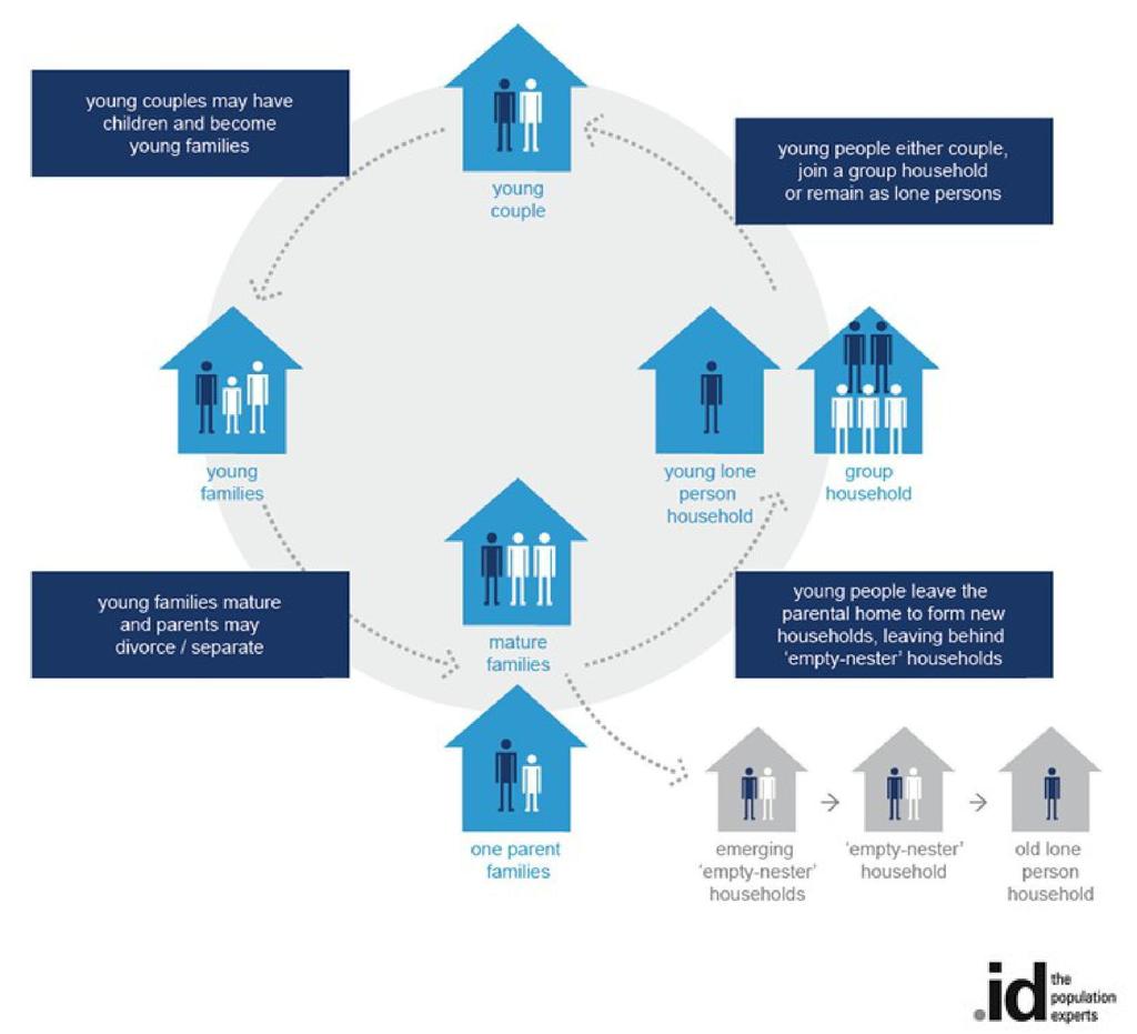
78 Household and suburb life cycles Household life cycles The type of households that people live in and changing preferences over time affects the way in which a population changes. As people grow from children to adults and into old age, they change the type of households that they live in. The traditional path has been to start as a child in a family household, move into a group or lone person household as a youth, becoming a part of a couple relationship within 5-10 years. Rearing of children is followed by an empty-nester period and ultimately being a lone person, as partners die. Understanding the changes that people make at different ages in their life, and the different types of housing they are likely to consume at those life stages is an important factor in forecasting future population and household types. The life stage which the majority of households in an area are going through gives an insight into its location in the suburb life-cycle (see below), and the likely life-path of those households in the future. 78
79 Suburb life cycles The dominant household types present in a suburb or town - where the majority of the populations sit in the household life path - dictate in part the role and function of the area. This is shown by its place in the "suburb life cycle". New areas are typically settled by young households (young couples and young families, perhaps some mature families). As the families grow and mature, household size increases. After initial rapid development, most households "age in place", with slowly shifting demand for services, facilities and dwelling types. As households age further and children begin to leave home, the average household size decreases, resulting in more empty nester (two person) households, often still living in large family homes. Family breakups can also result in single parent families and lone person households. If a suburb can't attract young families back to the area, it slowly becomes populated by older couples whose children have left home and older lone persons whose partners have died, resulting in declining population for some time. Alternatively, if a suburb is in a location close to economic drivers of change, it may be able to attract families to move back into the older dwellings in the area, increasing household size and population again. This will generally happen sooner, with less loss of services if the area has a diversity of housing options suiting a wide variety of household types. Empty nesters are likely to downsize into lower maintenance properties, freeing up larger format housing for families to move into, and continue the cycle again. The loop in the diagram represents the process of sustainability of an area, if it can attract families back into older housing in the area. Depending on the proximity of an area to work and education it may also attract young lone persons and group households. The attractiveness of an area to family groups, group and lone person households is shown in the migration assumptions section. Generally, more diverse communities are more sustainable in the long term, as they are able to maintain a range of services and facilities useful to all age groups. Certain policy responses can influence the suburb life cycle in different directions. 79
80 80

81 Forecast modelling process Approach The diagram below describes the general approach used by.id in its population and household forecasts. An analysis of the current population and household structure often reveals the role and function of an area and the degree to which an area may be going through some form of demographic transition. Demographic changes, such as birth, death and migration rates are applied to the base population. At the same time, scrutiny of urban development drivers is undertaken (residential development opportunities, vacancy rates etc.). The combination of varied assumptions about these inputs results in forecast population and households by type. 81

82 Modelling process The modelling process used for producing the small-area forecasts is based on a 'bottom-up' approach, with all assumptions being derived from a local perspective. The components of the model are derived exclusively from housing and demographic assumptions. The drivers of the forecasts are predominantly based on levels of new residential development and demographic assumptions, such as in and out migration rates from the local areas. The diagram below describes the detail of the modelling process used by.id in its population and household forecasts. 82
Sunshine Coast Council
 Sunshine Coast Council Sunshine Coast Council area Population and Household Forecasts 2016 to 2026 population forecast 1 Table of contents Home 3 About the forecast areas 4 Drivers of population change
Council/private/Federal (Dept Environment, Qld Arts (agency) incorporated with other gymnasium facilities. wading pool, community pool
 incorporated with other gymnasium facilities. wading pool, community pool") Appendix 1: Social infrastructure category definitions The following table provides definitions of the infrastructure which are included as part of the Sunshine Coast Social Infrastructure Strategy 2011.
Appendix 1: Social infrastructure category definitions The following table provides definitions of the infrastructure which are included as part of the Sunshine Coast Social Infrastructure Strategy 2011.
Study, Live, Work and Play on Australia s Sunshine Coast
 YOUR FUTURE IS HERE Study, Live, Work and Play on Australia s Sunshine Coast #STUDYSUNSHINECOAST studysunshinecoast.com.au Welcome to Australia s Sunshine Coast! DARWIN TOOWOOMBA SUNSHINE COAST BRISBANE
The Sunshine Coast is part of the global community and generates wealth through export, high-value industries and new investment.
 3.2 Strategic intent 3.2.1 Shaping growth an overview In 2031, the Sunshine Coast is renowned for its vibrant economy, ecological values, unique character and strong sense of community. It is Australia
Sunshine Coast University Hospital (SCUH) service change Community consultation report. October 2016
 service change Community consultation report. October 2016") Sunshine Coast University Hospital (SCUH) service change Community consultation report October 2016 Contents Project background 1 How we planned your Sunshine Coast service change 2 How we consulted with
Sunshine Coast University Hospital (SCUH) service change Community consultation report October 2016 Contents Project background 1 How we planned your Sunshine Coast service change 2 How we consulted with
The Property Economics
 Nambour The Property Economics Location Nambour is a sub-tropical hinterland in the Sunshine Coast region. It is 15 kilometres from the major Sunshine Coast education and employment hub of Sippy Downs.
Sunshine Coast: Kawana Health Campus. December 2013
 Sunshine Coast: Kawana Health Campus December 2013 Kawana Health Campus Residential development at Birtinya* Overview The Kawana Health Campus will comprise state-of-the-art public and private hospital
BEACHSIDE ON THE PARK
 Built better. BEACHSIDE ON THE PARK Due Diligence Project Report (07) 5370 1800 info@builtbetter.com.au builtbetter.com.au 1 builtbetter.com.au WELCOME TO BEACHSIDE Beachside on the park has been Constructed
Schedule 5 Designation of premises for development Schedule 5 Land designated for community infrastructure
 Contents of Schedule 5 Schedule 5 Designation of premises for development... 5-1 Schedule 5 Land designated for... 5-1 Tables in Schedule 5 Table SC5.1Designation of premises for development of under section
Built better. HARMONY. Due Diligence Project Report. (07) builtbetter.com.au. 1 builtbetter.com.
 builtbetter.com.au. 1 builtbetter.com.") Built better. HARMONY Due Diligence Project Report (07) 5370 1800 info@ 1 WELCOME TO HARMONY BRISBANE SUNSHINE COAST HARMONY SYDNEY 02 Built Better. MELBOURNE S 03 0 Built Better. OVERVIEW OF THE SUNSHINE
Built better. HARMONY Due Diligence Project Report (07) 5370 1800 info@ 1 WELCOME TO HARMONY BRISBANE SUNSHINE COAST HARMONY SYDNEY 02 Built Better. MELBOURNE S 03 0 Built Better. OVERVIEW OF THE SUNSHINE
11 JORL COURT, BUDERIM
 11 JORL COURT, BUDERIM 2 & 3 BEDROOM TOWNHOUSES Located in the centre of the education precinct, 11 Jorl Court presents a great buying opportunity for anyone wishing to get into the housing market or
Ascent SUNSHINE COAST
 Ascent SUNSHINE COAST Introducing... Ascent SUNSHINE COAST There is no need to choose between the East Coast s pristine beaches or breathtaking hinterland, at Ascent Sunsine Coast, you can have it all.
marketview Australian housing markets report Sunshine Coast solid again and rising Dr Andrew Wilson Domain Group senior economist March 2015
 Australian housing markets report Sunshine Coast solid again and rising Dr Andrew Wilson Domain Group senior economist March 2015 Copyright 2015 Dr Andrew Wilson all rights reserved Housing market model
Celebrate Festive Season
 Celebrate Festive Season Sunshine Coast Festive Season Guide 2012/13 Photo: Raoul Slater Your free program guide to the region s range of festive season community events and activities. Celebrate Festive
Newsletter No:6 - Mar 2017
 Contents Newsletter No:6 - Mar 2017 The cost of free education Message from our Funds Manager In recognition of our Sponsors Donation Box Locations What is Inclusive Kids? The cost of free education $500,000
Welcome. AITPM Queensland Branch Sunshine Coast Seminar May Wednesday 21 May 2008, 1.00pm 5.00pm
 Australian Institute of Traffic Planning and Management www.aitpm.com Welcome AITPM Queensland Branch Sunshine Coast Seminar May 2008 Wednesday 21 May 2008, 1.00pm 5.00pm Sebel Maroochydore 1 Australian
A Guide to Walking Tracks. on the Sunshine Coast
 A Guide to Walking Tracks on the Sunshine Coast Scenic Tracks & Lookouts Forest Tracks Beach, Coastal & Wetland Tracks 1 2 3 4 5 6 7 8 9 10 11 12 13 14 15 16 17 18 19 20 21 22 23 24 25 26 27 Bymien to
Environment Levy Annual Report
 Environment Levy Annual Report 2014-2015 Message from the Mayor Your Environment Levy in action for 2014-2015 The Sunshine Coast is without question a unique and special place and our region s natural
CONTENTS STOCKLAND INVITES YOU TO INVEST IN AURA 05 REGIONALLY & NATIONALLY SIGNIFICANT 06 AURA S COMPETITIVE ADVANTAGE 08 WHY INVEST IN AURA?
 PROSPECTUS CONTENTS STOCKLAND INVITES YOU TO INVEST IN AURA 05 REGIONALLY & NATIONALLY SIGNIFICANT 06 AURA S COMPETITIVE ADVANTAGE 08 WHY INVEST IN AURA? 10 AURA MASTERPLAN 12 BUSINESS PARKS 14 AURA CITY
Built better. AURA. Due Diligence Project Report. (07) builtbetter.com.au. 1 builtbetter.com.au
 builtbetter.com.au. 1 builtbetter.com.au") Built better. AURA Due Diligence Project Report (07) 5370 1800 info@ 1 WELCOME TO AURA Aura is a city where health, happiness and prosperity are right on your doorstep. This exciting new destination combines
Built better. AURA Due Diligence Project Report (07) 5370 1800 info@ 1 WELCOME TO AURA Aura is a city where health, happiness and prosperity are right on your doorstep. This exciting new destination combines
Built better. CREEKWOOD. Due Diligence Project Report. (07) builtbetter.com.au. 1 builtbetter.com.
 builtbetter.com.au. 1 builtbetter.com.") Built better. CREEKWOOD Due Diligence Project Report (07) 5370 1800 info@ 1 WELCOME TO CREEKWOOD With its lush, sub-tropical landscape, Creekwood is beautifully located between the cool pleasures of the
Built better. CREEKWOOD Due Diligence Project Report (07) 5370 1800 info@ 1 WELCOME TO CREEKWOOD With its lush, sub-tropical landscape, Creekwood is beautifully located between the cool pleasures of the
No : 3 - Ju l Sea FM supports Inclusive Kids
 Contents Sea FM supports Inclusive Kids Message from our Funds Manager Funding Allocations 2015-2016 N e w sl etter Donation Box Locations No : 3 - Ju l 2 0 1 6 What is Inclusive Kids? Sea FM supports
56 th Sunshine Coast Carnival 2018 WINTER BOWLS. Bowl in the Sunshine from the Hinterland to the Coast. visitsunshinecoast.com
 56 th Sunshine Coast Carnival 2018 WINTER BOWLS Bowl in the Sunshine from the Hinterland to the Coast visitsunshinecoast.com WELCOME President s Introduction On behalf of the Sunshine Coast District Bowls
Your Transport Levy Your Transport Future. Sunshine Coast Council Transport Levy Annual Report
 Your Transport Levy Your Transport Future Sunshine Coast Council Transport Levy Annual Report 2016-2017 www.sunshinecoast.qld.gov.au T 07 5475 7272 F 07 5475 7277 Locked Bag 72 Sunshine Coast Mail Centre
Sunshine Coast Residential Market
 Sunshine Coast Residential Market Warwick Temby HIA Executive Director, QLD HOUSING INDUSTRY ASSOCIATION April 2010 Overview Look at international, national and local events that are shaping the outlook
Newsletter No:4 - Sept 2016
 Contents Newsletter No:4 - Sept 2016 Inclusive Kids is off to Cairns Message from our Funds Manager Recipient Spotlight Donation Box Locations What is Inclusive Kids? Now Supporting the Cairns District
Sunshine Coast Regional Council Subordinate Local Law No. 2 (Animal Management) 2011
 2011") Sunshine Coast Regional Council Subordinate Local Law No. 2 (Animal Management) 2011 CONSOLIDATED VERSION NO.4 as in force on 31 March 2017 adopted by Sunshine Coast Regional Council on 20 April 2017 pursuant
Sunshine Coast Regional Council Subordinate Local Law No. 2 (Animal Management) 2011 CONSOLIDATED VERSION NO.4 as in force on 31 March 2017 adopted by Sunshine Coast Regional Council on 20 April 2017 pursuant
Authentic Sunshine Coast Living PH:
 Authentic Sunshine Coast Living PH: 07 3198 6200 Live in HARMONY Imagine a life free of the hustle and bustle of the city. Picture a place brimming with the warmth of the community. A home more connected
Built better. HARMONY. Due Diligence Project Report. (07) builtbetter.com.au. 1 builtbetter.com.
 builtbetter.com.au. 1 builtbetter.com.") Built better. HARMONY Due Diligence Project Report (07) 5370 1800 info@ 1 WELCOME TO HARMONY Harmony Is A 3 Billion Dollar Masterplanned First For South-East Queensland Harmony is the only masterplanned
Built better. HARMONY Due Diligence Project Report (07) 5370 1800 info@ 1 WELCOME TO HARMONY Harmony Is A 3 Billion Dollar Masterplanned First For South-East Queensland Harmony is the only masterplanned
WHY INVEST IN QUEENSLAND URBIS MARKET OUTLOOK
 WHY INVEST IN QUEENSLAND URBIS MARKET OUTLOOK WHO IS URBIS? PERTH AUSTRALIA ADELAIDE BRISBANE GOLD COAST SYDNEY MELBOURNE Urbis is an integrated multi-disciplinary consulting firm with a unique and comprehensive
REGATTA MEWS DUE DILIGENCE PROJECT REPORT REGATTA MEWS
 REGATTA MEWS DUE DILIGENCE PROJECT REPORT R M REGATTA MEWS REGATTA MEWS PROJECT DETAILS PROJECT: Regatta Mews, Wurtulla LOCATION: Lot 1888, Nicklin Way (corner of Regatta Boulevard) Wurtulla, QLD 4575
Population growth highlights and trends. the Wide Bay - Burnett Region 2005
 Population growth highlights and trends the Wide Bay - Burnett Region 2005 Minister s Message Welcome to the 2005 edition of Population growth highlights and trends, Wide Bay Burnett Region. This report
OUTLOOK REDBANK PLAINS A CONTEXT ON BUSINESS, CULTURE, LIFESTYLE AND RESIDENTIAL
 OUTLOOK REDBANK PLAINS A CONTEXT ON BUSINESS, CULTURE, LIFESTYLE AND RESIDENTIAL Located within seven minutes of the Springfield CBD and 30 minutes of the Brisbane CBD, Redbank Plains proximity to major
Sunshine Coast Light Rail Route Options Consultation Report
 Sunshine Coast Light Rail Route Options Consultation Report May 2015 Sunshine Coast Light Rail Route Options Consultation Report DISCLAIMER Information contained in this document is based on available
Draft Greater Sydney Region Plan
 Draft Greater Sydney Region Plan Submission_id: 31221 Date of Lodgment: 13 Dec 2017 Origin of Submission: Online Organisation name: Infrastructure Group Organisation type: Other First name: Jacob Ibrahim
The Airport Project MAROOCHY RIVER MAROOCHYDORE RD BRUCE HIGHWAY. The Space Between 40MIN BY CAR TO FUTURE CITY CENTRE MOOLOOLAH RIVER
 Strategic Context Major Development Area Recreational/ourism Zones Local Plan Area Boundary Study Area Area of Significant Population Water Body rain Line Kondalilla National Park Hinterland & Elevation,
New Year s Eve Mooloolaba
 40717 M 40717 Myy Ch Christm Chr hristmas istmas as Pu Pu Publi ublicati blica cation ation on 2014 2014 260x 260x260 x260 COVER COVER TO PR PRINT PRI RINT NT indd indd 1 77//11 7/11/2014 /11/ 11//20 2001
SEQ Catalyst Projects
 m3property Update SEQ Catalyst Projects Winter 2018 Since our Autumn Catalyst Projects report, several projects in South East Queensland s pipeline of major projects have progressed and several new projects
WHERE BUSINESS LEADS MAKE YOUR MARK. A unique opportunity for investors and developers.
 MAKE YOUR MARK WHERE BUSINESS LEADS A unique opportunity for investors and developers. Australia s only greenfield central business district within an existing urban area. 6 Dr Doug McTaggart Chairman,
ASCOT SUBURB PROFILE
 ASCOT SUBURB PROFILE CONTENTS SUBURB HIGHLIGHTS 2 3 4 4 5 5 ASCOT & SURROUNDS LOCATION & LIFESTYLE DEMOGRAPHICS EMPLOYMENT FUTURE INFRASTRUCTURE WA MARKET TRENDS ACCESSIBILITY ENTERTAINMENT & RECREATION
GRANT THORNTON BANKERS BOOT CAMP
 GRANT THORNTON BANKERS BOOT CAMP Where are we in the cycle? Yield compression slowing, rents growing Yields bottoming but the bottom could last till 2020 The end of yield compression brings income return
Know your market and build your business. How understanding target markets and local demographic/economic information can help local business
 Know your market and build your business How understanding target markets and local demographic/economic information can help local business March 24, 2015 About informed decisions.id stands for informed
market-view Australian housing markets report Residential construction on the rise - higher and higher?
 Australian housing markets report Residential construction on the rise - higher and higher? Dr Andrew Wilson Chief Economist Domain Group October 2016 Copyright 2016 Dr Andrew Wilson all rights reserved
UDIA Development Showcase ~ Sunshine Coast Adrian Allen ~ Project Director Caloundra South 25 February 2015
 UDIA Development Showcase ~ Sunshine Coast Adrian Allen ~ Project Director Caloundra South 25 February 2015 Overview Context Market Health Stockland on the Sunshine Coast Oceanside Overview Next 12 months
1, 2, 3 & 4 BEDROOM WATERFRONT APARTMENTS
 1, 2, 3 & 4 BEDROOM WATERFRONT APARTMENTS REVIVE OCEANSIDE, BRIGHT PLACE 7 hours of Sunshine 300 days a year! B I R T I N YA WHY INVEST IN THE SUNSHINE COAST? Population Growth Population growth projected
PINE RIVER - CABOOLTURE INCLUDING: GRIFFIN, KALLANGUR, MORAYFIELD & MANGO HILL/NORTH LAKES
 PINE RIVER - CABOOLTURE INCLUDING: GRIFFIN, KALLANGUR, MORAFIELD & MANGO HILL/NORTH LAKES AREA SUMMAR The Pine River - Caboolture area is located in south-east Queensland, between 20 and 44 kilometres
OUTLOOK EAST LEPPINGTON
 OUTLOOK EAST LEPPINGTON A CONTEXT ON BUSINESS, CULTURE, LIFESTYLE AND RESIDENTIAL Located within the rapidly expanding South West Growth Centre of Sydney, the East Leppington Precinct is well positioned
3.4 Economic development
 3.4 conomic development Key concepts (1) A prosperous, high value economy of choice for business, investment and employment. (2) ajor public infrastructure development associated with game changer projects
GOLD COAST HOUSING REPORT SNAPSHOT
 GOLD COAST HOUSING REPORT SNAPSHOT Few cities have expanded like the Gold Coast. The once iconic surfing Mecca and holiday destination has grown to become the 6th largest city in Australia with a population
Gold Coast: Modelled Future PIA Queensland Awards for Planning Excellence 2014 Nomination under Cutting Edge Research category
 Gold Coast: Modelled Future PIA Queensland Awards for Planning Excellence 2014 Nomination under Cutting Edge Research category Jointly nominated by SGS Economics and Planning and City of Gold Coast August
the allure of the ocean
 MOOLOOLABA the allure of the ocean THE PROJECT premium coastal living ARCHITECTURALLY DESIGNED 1, 2 & 3 BEDROOM LUXURY BEACHSIDE APARTMENTS As the name so fittingly suggests, Allure is captivating in both
Environment Levy Quarterly Report October-December 2016
 Environment Levy Quarterly Report October-December 2016 Welcome to the October December 2016 Quarterly Report for the Sunshine Coast Council s Environment Levy. The Environment Levy assists Council and
Sustainable Urban Development. Presentation to WVCC 1 December 2010
 Sustainable Urban Development Presentation to WVCC 1 December 2010 Introduction Paul Carmody Hindmarsh (Consultation Manager) Tony Adams CB Richard Ellis (Planners) Simon Parsons PTW (Architects) Brett
South Australia Property Report January 2014
 South Australia Property Report National Overview This quarter we look around the nation to identify affordable properties with the potential to deliver healthy long term gains suitable for first home
Sunshine Coast Recreation Trail Plan 2012
 Sunshine Coast Recreation Trail Plan 2012 Recreation Trail Reference Group The Recreation Trail Reference Group was established to provide input and guidance into the development of this Sunshine Coast
Sunshine Coast and Caloundra Airports Aircraft Noise Information Report
 Sunshine Coast and Caloundra Airports Aircraft Noise Information Report Quarter 1 2014 (January to March) 1 Version Control Version Number Detail Prepared by Date 1 - Environment June 2014 2 Updated text
looking forward to 2030
 looking forward to 2030 Draft for comment introduction The Sunshine Coast s first community plan documents our community s vision, values and aspirations for the next 20 years. It recognises that we are
Fairfax ANNUAL REPORT. Ferit, sequi doluptaecum et aut atisquatem remperferum nihilitis eribereperi offictaqui aut etus, tem est, voluptae nonserf.
 Ferit, sequi doluptaecum et aut atisquatem remperferum nihilitis eribereperi offictaqui aut etus, tem est, voluptae nonserf. Ted O Brien Fairfax ANNUAL REPORT www.tedobrien.com.au I am pleased to present
Contents Manningham at a Glance... 6 Location and Area... 6 Manningham Activity Centres... 6 Manningham Suburbs... 6 Population... 8 Forecast... 9 For
 Contents Manningham at a Glance... 6 Location and Area... 6 Manningham Activity Centres... 6 Manningham Suburbs... 6 Population... 8 Forecast... 9 Forecast 2011 2036... 9 Population Forecast... 9 Gross
Location Report. Coffs Harbour U Retire ( ) Retire with Property
 Retire with Property") Location Report Coffs Harbour Retire with Property 1300 U Retire (873 847) www.superannuationproperty.com Coffs Harbour Location Coffs Harbour is a regional town on the North Coast of New South Wales
Location Report Coffs Harbour Retire with Property 1300 U Retire (873 847) www.superannuationproperty.com Coffs Harbour Location Coffs Harbour is a regional town on the North Coast of New South Wales
COFFS HARBOUR MARKETSNAPSHOT
 MARKETSNAPSHOT NEW SOUTH WALES The Mid North Coast region is ranked fourth in Australia for business confidence with its regional economy growing at a healthy 4.1% p.a. and produces an annual Gross Regional
INVEST IN A NEW OUTLOOK ON LIFE GET YOUR SLICE OF PARADISE SET ACROSS 300 ACRES OF NATURAL SPLENDOUR.
 INVEST IN A NEW OUTLOOK ON LIFE GET YOUR SLICE OF PARADISE SET ACROSS 300 ACRES OF NATURAL SPLENDOUR. WELCOME IMAGINE yourself relaxing by a warm fire as you take in a majestic view of the surrounding
STRINGYBARK PLACE TO GROW STRINGYBARK PLACE The University of the Sunshine Coast
 PLACE TO INVEST STRINGYBARK PLACE is the flagship residential development of Nautilus Investments Corporation. In a high-demand area where rental and capital investment are set to provide a stable return,
Capital Works Delivery News. January March 2018
 Capital Works Delivery News January March 2018 Glasshouse District Park Stage 3 & 4, Amenities and Car Park Damien Large Jason Lemberg / Stage 4 Erscon Consulting Stage 3- Greenwood Landscape Management
Western Australia Property Report January 2014
 Western Australia Property Report National Overview This quarter we look around the nation to identify affordable properties with the potential to deliver healthy long term gains suitable for first home
BUILDING INDUSTRY OUTLOOK 2018
 BUILDING INDUSTRY OUTLOOK 2018 Welcome to the 2018 edition of Master Builders Building industry outlook, a snapshot of the state of Queensland s building and construction industry. Contents Foreword...3
Subject: DRAFT INTEGRATED TRANSPORT STRATEGY
 Recognising and upholding excellence in local government Mail: PO Box 105 Coolum Beach QLD 4573 Mobile: 0417 577 881 Email: president@oscar.org.au 20 July 2018 The Chief Executive Officer Sunshine Coast
Brisbane Population Update
 April 28, 2016 Brisbane Population Update When it comes to property, population is important. From a high-level perspective, it is a key market driver. Macquarie Bank sees it as the key driver of housing
Sunshine Coast and Caloundra Airports Aircraft Noise Information Report
 Sunshine Coast and Caloundra Airports Aircraft Noise Information Report Quarter 1 2015 (January to March) 1 Version Control Version Number Detail Prepared by Date 1 - Environment June 2015 Airservices
Caloundra South overview Ben Allen, General Manager Sustainable Communities
 CONTENT Caloundra South overview Ben Allen, General Manager Sustainable Communities Planning and Approvals status update Marc Wilkinson, QLD Planning and Approvals Manager Masterplanning and delivery Ben
Land area 1.73 million km 2 Queensland population (as at 31 December 2017) Brisbane population* (preliminary estimate as at 30 June 2017)
 Brisbane population* (preliminary estimate as at 30 June 2017)") Queensland - 11 Queensland OVERVIEW Queensland is nearly five times the size of Japan, seven times the size of Great Britain, and two and a half times the size of Texas. Queensland is Australia s second
Queensland - 11 Queensland OVERVIEW Queensland is nearly five times the size of Japan, seven times the size of Great Britain, and two and a half times the size of Texas. Queensland is Australia s second
RESIDENTIAL COMMUNITY PARK RIDGE T R A N Q U I L I T Y D R I V E AT PARK RIDGE
 RESIDENTIAL COMMUNITY PARK RIDGE T R A N Q U I L I T Y D R I V E AT PARK RIDGE TRANQUILITY DRIVE ESTATE is a residential community at Park Ridge, south of Brisbane, in sunny Queensland, Australia. Surrounded
DATE 23 February, Integrated Transport Strategy. Halls Creek. For Stockland
 Halls Creek For Stockland DATE 23 February, 2015 CONTACT STEVE WILLIAMS EXECUTIVE SUMMARY The Halls Creek Identified Growth Area (IGA) has been identified within the South East Queensland Regional Plan
investment ProSPeCTuS 2016 SuMMary
 investment ProSPeCTuS 2016 SuMMary 2 invest SuNShiNe CoaST - The future is here MeSSaGe from The Mayor MeSSaGe from The Mayor a CiTy region of opportunity The Sunshine Coast offers investors an unrivalled
Information about services and resources for new families moving the the Caloundra and Maroochy Coastal and Hinterland areas.
 Resourc e Bookl et Information about services and resources for new families moving the the Caloundra and Maroochy Coastal and Hinterland areas. Contents 3 Accommodation / Housing Services 4 Early Learning
PORT DOUGLAS SUBURB REPORT
 PORT DOUGLAS SUBURB REPORT LOCALITY Port Douglas is an internationally acclaimed tropical coastal holiday destination 70 kilometres north of Cairns. Access from Cairns is via the scenic Captain Cook Highway
SOVEREIGN PARK. An Exclusive Investment Opportunity. Brassall, QLD Located in Australia's Fastest Growing City. Creating Cashflow Through Property
 An Exclusive Investment Opportunity Located in Australia's Fastest Growing City Sovereign Park Estate Sovereign Park Estate is an exclusive opportunity for investors to secure pre-construction pricing
Western Australia Property Report July 2014
 Western Australia Property Report National Overview Upgraders seize opportunities The past 12 months have provided an abundance of opportunities for upgraders to climb the property ladder. Interest rates
Contents. Introduction 3 Chapter 1 Social Dimension 5. Summary 51
 City Growth Story 2018 Contents Introduction 3 Chapter 1 Social Dimension 5 Summary 5 Population growth and change 6 Population growth 6 Population by age 8 Ageing of the population 9 Household growth
Sunshine Coast and Caloundra Airports Aircraft Noise Information Report
 Sunshine Coast and Caloundra Airports Aircraft Noise Information Report Quarter 3 2015 (July to September) 1 Version Control Version Number Detail Prepared by Date 1 - Environment December 2015 Airservices
Housing in Hobart: an overview of the data. Richard Eccleston, Lisa Denny, Julia Verdouw & Kathleen Flanagan University of Tasmania May 2018
 Housing in Hobart: an overview of the data Richard Eccleston, Lisa Denny, Julia Verdouw & Kathleen Flanagan University of Tasmania May 2018 Informing the Housing Debate Tasmania is facing significant housing
WRIGHT DENMAN PROSPECT AREA PROFILE MACRO PLAN DIMASO
 WRIGHT DENMAN PROSPECT AREA PROFILE CONTENTS WHY CANBERRA? PG 04 INVEST IN THE MOLONGLO VALLEY PG 06 3 PROPERTY GROUP PG 08 DETAILED INVESTMENT ANALYSIS PG 11 Population Growth Demographics Tenure & Typology
*Artist Impression. *Artist Impression
 Your Urban Oasis Urban Ingenuity It s not hard to feel renewed and inspired at Forest Ridge Estate, where you can experience beautiful countryside, wide-open spaces, and retain all the advantages of City
Investor Briefings First-Half FY2016 Financial Results
 Cedar Woods Properties Limited Investor Briefings First-Half FY2016 Financial Results 26 February 2016 Cedar Woods Presentation 2 Snapshot of Achievements in FY2016 Extensive portfolio of residential estates
Marvellous. Victoria is in the midst of massive population growth but how will Australia s cultural capital fare in the future?
 Marvellous R E B O R N Victoria is in the midst of massive population growth but how will Australia s cultural capital fare in the future? December 2017 Contents 3 5 6 7 7 7 8 8 9 11 MARVELLOUS MELBOURNE
Sunshine Coast Council Locked Bag 72 Sunshine Coast Mail Centre QLD Submitted via online portal. 2 June 2017.
 Sunshine Coast Council Locked Bag 72 Sunshine Coast Mail Centre QLD 4560 Submitted via online portal 2 June 2017 Dear Sir /Madam, RE: DRAFT ENVIRONMENTAL AND LIVEABILITY STRATEGY The Green Building Council
A TRIBECA AREA FACT FILE
 03 A TRIBECA AREA FACT FILE SOUTH WEST MELBOURNE FOCUS AREA: TARNEIT AREA PROFILE AREA PROFILE: This report encompasses the South West Melbourne growth precinct of Wyndham. Specifically, the demographic
construction of cycling facilities along David Low Way, between Warran Road and Williams Street.
 North Coast North Coast Maroochydore office 12 First Avenue Maroochydore Qld 4558 PO Box 1600 Maroochydore Qld 4558 (07) 5451 7055 sunshinecoast.office@tmr.qld.gov.au Divider image: Interchange works on
STONES CORNER SUBURBPROFILE. Situated three kilometres from the Brisbane CBD, Stones Corner is located within one of Brisbane s key growth areas.
 1 SUBURBPROFILE Situated three kilometres from the Brisbane CBD, Stones Corner is located within one of Brisbane s key growth areas. OVERVIEW Situated three kilometres from the Brisbane CBD, Stones Corner
MARKET OUTLOOK. 01 Walkability & Accessibility 02 Infrastructure & Employment 03 Demographics 04 Residential Analysis 06 Rental Analysis
 MARKET OUTLOOK EAST LEPPINGTON Located within the rapidly expanding South West Growth Centre of Sydney, the East Leppington Precinct is well positioned to benefit from the region s strong infrastructure
DEXUS Property Group (ASX: DXS) ASX release
 ASX release") 6 May 2013 DEXUS and DWPF to acquire strategic office investment in Perth DEXUS Property Group (DEXUS or DXS) and DEXUS Wholesale Property Fund (DWPF) today announced the joint acquisition of a strategic
6 May 2013 DEXUS and DWPF to acquire strategic office investment in Perth DEXUS Property Group (DEXUS or DXS) and DEXUS Wholesale Property Fund (DWPF) today announced the joint acquisition of a strategic
SUNSHINE COAST. State of the Region
 SUNSHINE COAST State of the Region 2012-31 1 Acknowledgements Compilation of the RDA Sunshine Coast 2012 State of the Region Report was coordinated and edited by RDA Sunshine Coast team consisting of CEO
Land area 1.73 million km 2 Queensland population (as at December 2016) Brisbane population* (preliminary estimate as at 30 June 2016)
 Brisbane population* (preliminary estimate as at 30 June 2016)") Queensland - 11 Queensland OVERVIEW Queensland is nearly five times the size of Japan, seven times the size of Great Britain, and two and a half times the size of Texas. Queensland is Australia s second
Queensland - 11 Queensland OVERVIEW Queensland is nearly five times the size of Japan, seven times the size of Great Britain, and two and a half times the size of Texas. Queensland is Australia s second
CHAPTER 2 COUNTY PROFILE
 COUNTY PROFILE CHAPTER 2: COUNTY PROFILE This chapter provides a profile of Amador County, California, in the planning context of parks and recreation services. This profile includes a description of the
MARKET OUTLOOK. 02 Walkability & Accessibility 04 Infrastructure & Employment 05 Population & Demographics 06 Residential Analysis 07 Rental Analysis
 MARKET OUTLOOK ROCHEDALE With easy access to the major arterial roads and public transport links, Rochedale s connectivity has positioned it as a major growth precinct for the future. 02 Walkability &
Review of Government Secondary School Requirements within the Sunbury South Precinct Structure Plan
 Review of Government Secondary School Requirements within the Sunbury South Precinct Structure Plan Expert Witness Statement August 11 th, 2017 Prepared by Robert Panozzo Director, ASR Research Pty Ltd
Holmview, BRISBANE QLD
 Holmview, BRISBANE QLD HAVEN HILL - LOCATION Holmview PRIME LOCATION LOCATION Holmview is part of the Logan City Council region and is located nearly half way between the Gold Coast and Brisbane on the
PCAL Case Study Retail Areas: Rouse Hill Town Centre
 PCAL Case Study Retail Areas: Rouse Hill Town Centre Introduction Rouse Hill Town Centre is a new mixed use development on a greenfield site in Sydney s North West. It has been planned to be a major hub
GROWTH AREA PROFILES CITY CENTRES. Henderson. Past. g r o w t h management s t r a t e g y. Henderson 1940
 CITY CENTRES Past In 1940 was still a relatively small rural service town, surrounded by established vineyards and orchards, the Borough having a total population of approximately 1,500 people. By the
STAGE PLAN STAGE 4B REEF RELEASE LEGEND. Lot Height. Display Village Previous Release. Current Release. Retaining Wall Sold.
 STAGE PLAN STAGE 4B REEF RELEASE 6.54 7.28 7.43 7.30 7.40 7.80 7.50 7.97 PGOL0466.030216 TAMBREY AVENUE LEGEND Lot Height Current Release Display Village Previous Release Group Housing Retaining Wall Sold