San Rafael General Plan Bus Tour Workbook
|
|
|
- Rosanna Grant
- 5 years ago
- Views:
Transcription


1 San Rafael General Plan 2040 Bus Tour Workbook June 13, 2018
2 Blank Back of Cover 2
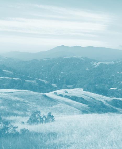
3 Welcome to the San Rafael 2040 General Plan Steering Committee Bus Tour! The purpose of today s tour is to highlight long-range planning issues around the city, and to showcase San Rafael s diverse neighborhoods and landscapes. Think about the places you re seeing today and how they might change in the next 20 years. The tour route is 32 miles long and is located entirely within the San Rafael Planning Area. While the route can be driven in 90 minutes, our tour today will be 3 to 3.5 hours in length to allow for several stops along the way. The focus of the tour is not only on land use and development issues. Our route will highlight many General Plan topics, including housing, equity, transportation, natural hazards, conservation, sustainability, historic preservation, parks and open space, and community facilities. The purpose of this Workbook is to chart our route (including General Plan designations!), provide background information about what you ll be seeing, and give you space to jot down your thoughts and ideas. We ll be collecting the workbooks at the end of the tour to transcribe your responses and share them with the group. Sit back, have fun, and enjoy the tour! 3
4 Itinerary ( indicates we will disembark) # Location 0 CITY HALL (Starting point) 1 Anderson Drive / Woodland corridor 2 Marin Square/ Bellam Blvd 3 East San Rafael Business District/ Canalways 4 Pickleweed/ Tischonia Marsh 5 Al Boro Community Center/ Canal neighborhood 6 Francisco Blvd East 7 Montecito Shopping Center and environs/ SRHS 8 Pt San Pedro Peninsula, including Loch Lomond / Country Club area 9 Rock Quarry and Brick Works/ Peacock Gap Glenwood area 10 Dominican University and Dominican neighborhood 11 Marin County Civic Center and Lagoon Park 12 Civic Center SMART Station 13 Northgate Mall 14 Northgate Walk/ Northgate One 15 Gallinas Creek/ Terra Linda Shopping Center 16 Terra Linda Recreation Center/ Santa Margarita 17 Los Gamos corridor 18 Smith Ranch Planned Developments and Contempo Marin/ SR Airport 19 The Vineyard/ Northgate Business Park 20 Los Ranchitos/ Redwood Village 21 Downtown Transit Center / Smart Station Area 22 3 rd Street Corridor 23 Downtown West End CITY HALL (Ending point) 4

5 START/ END

6 Mileage Key Map Directions 0.0 Depart City Hall eastbound on 5 th Avenue Right on A Street A Street becomes Andersen; continue forward 6
7 1 Andersen Drive / Woodland Corridor South of City Hall, a new 43,500 sq. ft. Public Safety Center is under construction. This project was made possible by Measure E (2013), a sales tax increase to replace aging fire stations and public safety facilities. As we exit Downtown, note the San Rafael Corporate Center on the left. Andersen Drive was built to provide a cross-town bypass from Downtown ( A Street) to the Richmond/ San Rafael bridge. A segment of Andersen is temporarily closed due to construction related to the SMART extension to Larkspur. The Woodland/Andersen corridor is an essential part of San Rafael s tax base and an important source of local jobs and services. It has the highest concentration of home goods and services in Marin County. The corridor has been designated for industry in the last two General Plans to protect its function in the local and regional economies. Thoughts and Observations 7
 2.1 2 2.")
8 Mileage Key Map Directions Right on Du Bois Left on Woodland Left on Auburn Left on Andersen and immediate right on Gary Place (Marin Square) Left on Bellam Exit Marin Square right on Andersen, immediate U-turn, back to Bellam intersection Go under 580, then right on Francisco E. 8
9 2 Marin Square/ Bellam Blvd Marin Square Shopping Center is a former drive-in movie site that has been used for commerce and industry since the 1970s. Site constraints include access, traffic, and potential future impacts from ramps connecting Highway 101 to I-580. Marin Square was addressed in General Plan 2020 past proposals for housing and retail uses have not come to fruition. Sutter Health purchased the center and surrounding properties) 5-10 years ago with the intent to develop a medical center and support services. The site is being sold more than 30 offers were received. New owner may upgrade the retail center, and consider other uses. Bellam Blvd is one of the most congested areas in San Rafael. The current General Plan calls for another crossing of I-580, either at Irene St. or Shoreline Pkwy. This would be a very expensive improvement, and could not be covered by traffic mitigation fees alone. Thoughts and Observations 9

10 Mileage Key Map Directions 3 Continue forward on Francisco E Left on Shoreline Parkway Left on Kerner then turn around in parking lot and return to Shoreline Pkwy Shoreline Parkway back to Francisco, right on Francisco Right on Irene Left on Kerner 10
11 3 Shoreline Center/ Canalways Francisco Blvd East includes heavy commercial and industrial uses. East San Rafael is a major employment center, contributing roughly 2/3 of the City s sales tax dollars. Shoreline Center was a former landfill. It was master planned as a retail power center in the late 1990s. The elevation of this area is higher than its surroundings; thus, it is less vulnerable to sea level rise. The Canalways site was the subject of much discussion in the last General Plan Update. There are currently two designations for the site Light Industrial/ Office and Conservation. New studies of wetlands and sensitive species are needed to determine appropriate future activities here. Thoughts and Observations 11

12 Mileage Key Map Directions 3 Continue forward on Kerner Right on Bellam Left on Catalina Left on Spinnaker Point Dr. Disembark at Al Boro Community Center 12
13 4 Spinnaker Point/ Baypoint Lagoon Pickleweed/ Tisconia Marsh The one-way pairing of Irene, Francisco, and Kerner created a traffic loop that increased road capacity in the industrial area. The County Health and Wellness Center was developed about 10 years ago on properties formerly owned by Industrial Light and Magic. Cardenas Market was formerly Mi Pueblo, which was formerly Circuit City, which was formerly Goodmans Lumber. Canal Community Garden was funded by the Trust for Public Land. Spinnaker Point and Baypoint Lagoon were former marshes that were diked off by shoreline levees. These areas were filled with spoils from canal dredging, with development starting in the late 1970s-early 1980s. Tisconia Marsh extends north of Spinnaker to the Bay. A Marsh Habitat Restoration / Sea Level Rise Adaptation Project is underway here. Thoughts and Observations 13

14 Mileage Key Map Directions 3 Exit Al Boro Center onto Canal Street Left on Kerner Right on Novato Left on Canal. Bear right to continue on Canal at intersection with Medway Left on Harbor Right on Francisco E.; Francisco becomes Grand 14
15 5 & 6 Al Boro Community Center Canal Neighborhood Francisco Blvd East The Canal area is the most densely populated neighborhood in Marin County. It was initially developed as rental apartments in the 1950s and 60s. The Canal has seen a number of demographic shifts. It had a large Vietnamese community in the 1980s, and today is approximately 80% Latino. Population grew by 50% from 1990 to 2013 without a commensurate increase in housing units. The Canal area also includes hundreds of small businesses, including many auto service uses. The area is also vulnerable to sea level rise and flooding. The Francisco corridor is the primary corridor from the Canal to Downtown. There have been several initiatives to improve bike, pedestrian, and transit access here. This area also includes several large car dealerships, as well as the Terrapin Crossroads a public private partnership to renovate a City park. Thoughts and Observations 15

16 Mileage Key Map Directions Continue on Grand Right on 2 nd St, which immediately merges with 3 rd St, which becomes Pt San Pedro Road 16
17 7 Montecito Shopping Center San Rafael HS Country Club A 12 wide pedestrian-bike bridge is being built where Grand Avenue crosses the Canal. Third Street is congested in this area, as it is the only major access route for some 11,000 residents on the Point San Pedro peninsula. Montecito Shopping Center was once a turning basin and marina. The shopping center was renovated in the 1980s, and an auxiliary parking lot was added to address the lack of sufficient parking. As currently designed, the site does not capitalize on its waterfront location. Fire Station 52 (at Grand) is being replaced with Measure E funds. Capital projects are also underway at San Rafael High School. Boat basins and marine uses make this a unique stretch of shoreline Much of Point San Pedro Road sits only a few feet above the Bay, and will become more vulnerable as sea level rises. Thoughts and Observations 17
18 Mileage Key Map Directions Continue on Pt San Pedro, then right on Loch Lomond Dr Proceed to roundabout at Andy s Market then return on Loch Lomond Dr to Pt San Pedro Right on Pt San Pedro Continue on Pt San Pedro to just past McNear s Beach. Then left on San Marino 18
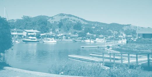
19 8 Loch Lomond Loch Lomond Marina Loch Lomond Marina has been an operating marina and grocery store since the late 1950s. Much of the site was undeveloped, which made it a focal point for discussion in General Plan General Plan 2020 goes into great detail about the future of this site, The site was approved for 81 units, including 17 below market rate units. The project includes Andy s Market and retention / improvement of Marina support facilities, A shoreline park area is included, as required by the City s parkland dedication requirements and BCDC public access mandates. Thoughts and Observations 19
20 Mileage Key Map Directions Continue on San Marino Left on Riviera Left on Via Montebello for vista only; then turn around and continue on San Marino Right on Pt San Pedro 20
21 9 Glenwood/ Peacock Gap Rock Quarry/ McNear Brick McNear Brick and the Rock Quarry are in unincorporated Marin County, but within the San Rafael Planning Area. McNear Brick manufactures brick products and pavers. The Rock Quarry has been in business for over a century and is the only waterfront quarry in Northern California that can transport materials via barge. The site is designated for mining and conservation by GP Aggregate mined at the site is used for construction throughout the region. The Reclamation Plan approved by the County extends to 2024, The current policy for the site is to consider new uses if the quarry ceases operation. Thoughts and Observations 21

22 Mileage Key Map Directions 10 Continue forward on Pt San Pedro Right on Grand Right on Acacia Left on Magnolia/ bear left at Poplar Right on Grand 22
23 10 Montecito/ Happy Valley Dominican The return route to Central San Rafael passes by several neighborhoods, including Peacock Gap, Glenwood, Loch Lomond, and Country Club. These are largely single family areas with very limited development potential. Some of the neighborhoods are unincorporated--and wish to remain that way. This is acknowledged by the General Plan, which allows for future annexation if local interest arises. There are interesting vistas across the Canal as it narrows toward Downtown. Dominican University is one of the oldest universities in California. Enrollment in was 1,812 students. The 80-acre campus has seen extensive building in the last 20 years. Issues associated with traffic, parking, and community character are being addressed proactively, with the help of a campus master plan. Thoughts and Observations 23
 19.")
24 Mileage Key Map Directions 10 Continue on Grand. Grand becomes Villa Enter Highway 101 North Exit at North Pt San Pedro and move into left lanes Left on Civic Center (San Pablo) Continue forward through Civic Center complex and past SMART station 24
25 11 & 12 Marin Civic Center Civic Center SMART Station North San Rafael is in many ways a community unto itself, with its own ZIP code, sanitation district, and commercial core. Much of this area was developed when it was unincorporated, and was later annexed to San Rafael. Note the 82-unit apartment building on the south side of Pt. San Pedro Road, called 33 North. This site was formerly an office building. To the east on Pt. San Pedro Road is Santa Venetia, and unincorporated community. General Plan 2020 anticipated that it would not be annexed due to the high costs of remediating flooding, seismic, and urban service issues. The Frank Lloyd Wright Civic Center opened in 1962 and has been listed on the National Register of Historic Places since The SMART station was the focus of the Civic Center Station Area Plan ( ); this area was originally identified as a potential Priority Development Area (PDA), but this designation was rescinded. Thoughts and Observations 25

26 Mileage Key Map Directions Continue forward through Civic Center complex and past SMART station Left on Merrydale, Continue forward into Northgate Mall Disembark at Northgate Exit Mall on Northgate Drive and continue forward to Freitas Parkway Left on Freitas Parkway (proposed Northgate Walk on right ) 26
27 13 & 14 Northgate Mall Northgate Walk The Merrydale overcrossing was built in the mid-1990s with traffic mitigation fees and an assessment district formed by property owners. Northgate Mall opened in 1965 and was enclosed in The Mall went through a major renovation in Its total floor area is approximately 725,000 square feet. The Mall was sold to Merlone Geier Partners in In addition to the Mall, the Northgate complex includes adjacent properties, such as the Northgate One Shopping Center (Safeway) and Northgate Three (CVS). Northgate Walk is a proposed 136-unit condominium complex adjacent to the Sheraton Four Points Hotel. The project has been scaled back in size several times from the original proposal. Thoughts and Observations 27
 23.")
28 Mileage Key Map Directions 14 Continue forward on Freitas Parkway (note Gallinas Creek) Right on Del Ganado Disembark at Terra Linda Recreation Center Return to bus, Del Ganado to Las Raposas. Right on Las Raposas Right on Los Colindas Left on Las Gallinas (at 4-way stop) Right on Lucas Valley Road 28
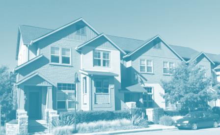
29 15 & 16 Terra Linda Santa Margarita Terra Linda and Santa Margarita neighborhoods were built in the 1950s and 60s. The neighborhoods include about 900 single story Eichler homes, as well as other ranch-style homes. Santa Margarita Creek was channelized as the area was developed (see center of Freitas Pkwy). Terra Linda Rec Center and Pool is a major community gathering place Much of this area is permanent open space; hillsides were acquired through a bond measure in the 1970s to protect them from development. San Rafael has over 7,300 acres of open space in its planning area, making this the largest single land use category in the city. Thoughts and Observations 29
.")
30 Mileage Key Map Directions Continue forward on Lucas Valley Road. Note Los Gamos Drive on right Lucas Valley passes under 101 and becomes Smith Ranch Rd Right on Yosemite Turn around at roundabout before Contempo, return to Smith Ranch, turn left Left on Redwood Highway Continue forward on Redwood Hwy (becomes Civic Center Dr at Freitas). Note The Vineyards and Northgate Business Park. Turn right at Merrydale. 30
31 17 & 18 & 19 Los Gamos/ Smith Ranch / Northgate Business Park The Los Gamos corridor includes several office buildings the two largest were formerly Fireman s Fund Los Gamos is now County offices; 1650 Los Gamos was purchased by Kaiser, who is planning a medical office complex. East of 101, the Smith Ranch Master Plan was implemented in the 1980 s. The Plan set a precedent for traffic mitigation fees, which were eventually required citywide. These fees funded road and intersection improvements. Contempo is a manufactured home community. The units are rent controlled by City ordinance. This was litigated by the owner but the City prevailed. There are about 100 planes based at San Rafael Airport, a private facility. An 85,000 sq. ft. indoor recreation facility has been approved on the site. On Redwood Highway, a former brownfield site (Fairchild semi-conductor) has been cleaned and redeveloped as the Vineyards (Costco also had been considered for this site). The small light industrial spaces in this area are good locations for incubating small businesses. There may also be opportunities for higher value uses on some of the older commercial sites. Thoughts and Observations 31

32 Mileage Key Map Directions Cross 101 on Merrydale, turn left on Los Ranchitos Note Redwood Village (on the Left) Los Ranchitos becomes Lincoln 32
33 20A Redwood Village Los Ranchitos Mt. Olivet Cemetery was established in Guide Dogs for the Blind is the largest guide dog school in the United States The tour route passes Redwood Village, which has 134 residential units. (including 21 below market rate units). The project is an example of how the City s inclusionary housing requirements (in-place since 1986) work in practice. Redwood Village included a public park and was controversial due to concerns over traffic. To the west, the Los Ranchitos neighborhood is unincorporated and includes large lots on steep winding streets. Vegetation management and wildfire prevention are critical in this landscape. Thoughts and Observations 33

34 Mileage Key Map Directions 21 Continue on Lincoln toward Downtown San Rafael Left on Mission Right on Hetherton 34
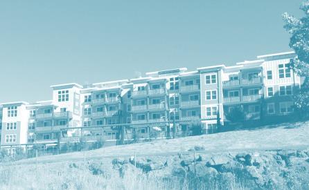
35 20B Lincoln Hill Lincoln Ave. north of Downtown San Rafael contains a mix of housing densities and land uses. Ventana Villas (1515 Lincoln) is one of the newer projects on the corridor, with townhome-style rental apartments. A bike and pedestrian path opened along the west side of Highway 101 in 2010 as part of the freeway widening project. Thoughts and Observations 35

36 Mileage Key Map Directions 21 Continue on Hetherton Right on Third 36
37 21 Station Area/ Transit Center The area around the San Rafael SMART Station was addressed by a Station Area Plan in The Plan includes recommendations for changes in land use and allowable height near the station, as well as circulation and streetscape improvements. The Bettini Transit Center needs to be relocated to make way for extension of SMART train service through the site. A study is underway to identify the new location. Several options are being considered. Parts of this area are only a few feet above sea level and may be flooded more frequently in the future due to sea level rise. Thoughts and Observations 37
 at merge with 2 nd")

38 Mileage Key Map Directions 22 Continue on Third St Continue forward (west bound) at merge with 2 nd Street Right on 4 th (at Shell Station) Left on E Return to City Hall to disembark 38
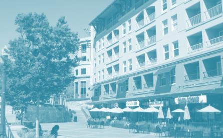
39 22 & 23 3 rd St. Corridor West End Several projects are proposed along Third Street near the east end of Downtown, including the Seagate apartments, and new office/laboratory facilities for Biomarin. A Third Street Corridor Plan is underway to beautify the street, improve traffic flow, and make the street safer for all modes of travel. The City limits are a little less than a mile beyond where the tour turns back onto Fourth Street. The West End area has more of a village feel than the Downtown core. Parking requirements in this area were relaxed 7-8 years ago. The project at 4 th and G is a good example of high-density residential that is consistent with the context and scale of the area. A separate (walking) tour will be done for Downtown as part of the Precise Plan process. Thoughts and Observations 39
40 Thank You for Participating! 40
SAN RAFAEL City Council January 20, 2015
 SONOMA MARIN AREA RAIL TRANSIT SMART CENTRAL SAN RAFAEL STATUS UPDATE SAN RAFAEL City Council January 20, 2015 CENTRAL SAN RAFAEL SMART SOUTH OF PUERTO SUELLO TUNNEL 1. Active Construction 2. Construction
SAN RAFAEL. Community Profile: San Rafael. Map 96. San Rafael Sea Level Rise and 100-year Storm Surge Scenarios
 Community Profile: San Rafael San Rafael is the Marin County seat and largest city. The city features an active boating sector, the largest downtown in the county, a university, and the county s largest
Part Three : COMMUNITY PLAN AREAS AND SPECIAL STUDY AREAS SACRAMENTO 2030 GENERAL PLAN. Introduction
 Special study Areas Part Three : COMMUNITY PLAN AREAS AND SPECIAL STUDY AREAS SACRAMENTO 2030 GENERAL PLAN Introduction Beyond the boundaries of the 2030 General Plan, the City has defined Special Study
Everett Riverwalk Life style explore
 Life style explore Project Overview The 217-acre Everett Riverfront redevelopment is visible from I-5 with traffic counts charted at 170,000+ vehicles per day with direct freeway access from 4-way interchange.
Marin County Transit District 2006 Draft Service Plan Revised: May 8 th, 2006
 Marin County Transit District 2006 Draft Service Plan Revised: May 8 th, 2006... 2... 4... 8 Marin Local Fixed Route Service... 8... 14 MCTD School Routes Operating for School Year 2006/2007...14 Other
Premier Office Space For Lease 111 Santa Rosa Avenue, Santa Rosa, CA
 Premier Office Space For Lease 111 Santa Rosa Avenue, Santa Rosa, CA 150 to 12,201 ± Sq. Ft. Available Westamerica Bank Building Downtown Underground and Surface Lot Parking Great Views From Upper Floors
Premier Office Space For Lease 111 Santa Rosa Avenue, Santa Rosa, CA
 Premier Office Space For Lease 111 Santa Rosa Avenue, Santa Rosa, CA 150 to 13,328 ± Sq. Ft. Available Westamerica Bank Building Downtown Underground and Surface Lot Parking Great Views From Upper Floors
SOUTH INTERCHANGE AREA
 Santaquin City General Plan 1 Location and Characteristics The South Interchange Area of Santaquin is located west of Interstate 15 and south of 500 South (Figure 1). It includes properties already annexed
RARE MARIN COUNTY TRIPLE NET INVESTMENT
 RARE MARIN COUNTY TRIPLE NET INVESTMENT ±29,000 SF ±3.33 ACRES $12,950,000 PAD B Parcel 4 PAD C Parcel 5 JERRY SUYDERHOUD Sr. Managing Director jsuyderhoud@ngkf.com O: 415.526.7660 CA RE License #00633998
SAN ANTONIO RIVER IMPROVEMENTS PROJECT. August 6, 2008
 SAN ANTONIO RIVER IMPROVEMENTS PROJECT August 6, 2008 1 History of the SA River Improvements 1921 Flood Olmos Dam Complete in 1929 Downtown Flood Relief Projects in 1950 s Dams on the River Channel and
RECREATION AND RESORT PROJECTS
 RECREATION AND RESORT PROJECTS Coyote Moon Golf Clubhouse, Truckee, CA Dollar Point Pool and Tennis Club, Tahoe City, CA Donner Lake Boat Ramp, Truckee, CA Tahoe Swiss Village Beach and Shore Frontage,
Clackamas County Development Agency
 Clackamas County Development Agency Development Services Building, 150 Beavercreek Rd., Oregon City, OR 97045 www.clackamas.us/transportation/renewal 503-742-4323 The Clackamas County Board of Commissioners
SAN ANTONIO RIVER IMPROVEMENTS PROJECT. April 27, 2009
 SAN ANTONIO RIVER IMPROVEMENTS PROJECT April 27, 2009 1 Project Limits 2 Project Partners City of San Antonio Provides project funding for project amenities (i.e.. Sidewalks, Landscaping, Lighting, etc.)
San Quentin Reuse Planning Committee Minutes Thursday, May 2, 2002 San Rafael Corporate Center
 San Quentin Reuse Planning Committee Minutes Thursday, May 2, 2002 San Rafael Corporate Center Committee Members Present: Alex Amoroso Al Boro John Dupar Phil Frank Steve Kinsey Joan Lundstrom for Larry
Task Force Meeting #2
 Task Force Meeting #2 July 9, 2013 Project Precedents Granville Island, Vancouver B.C. South Waterfront, Portland OR Jack London Square, Oakland CA Brooklyn Basin, Oakland CA Chula Vista Bayfront, Chula
S i t e A n a ly s i s
 S i t e A n a ly s i s 11 SECTION B SITE ANALYSIS Existing Conditions TRANSPORTATION CONTEXT: The Ohlone Greenway site, paralleling San Pablo Avenue to the west, is centrally located within the City of
Arizona s Most Unique Urban Opportunity
 An opportunity exists for the development and design community to rethink what to control and what not to control, recognizing that each context and each project are different. The goal remains unchanged:
110, 114 & 190 BICENTENNIAL WAY. HADEN ONGARO Executive Vice President RON REINKING Managing Director FOUNTAINGROVE PKWY LAKE PARK DR BICENTENNIAL WAY
 FOR SALE: 3 RETAIL PADS - HOME DEPOT ANCHOR 190 Parcel 3 APN: 173-060-004 ±1.87 ACRES $1,500,000 114 Parcel 4 APN: 173-060-003 ±1.11 ACRES $ 750,000 110 Parcel 5 APN: 173-060-010 ±0.91 ACRES $ 750,000
COASTAL CONSERVANCY. Staff Recommendation November 6, 2008 SAN FRANCISCO BAY TRAIL: CANAL BOULEVARD CONSTRUCTION
 COASTAL CONSERVANCY Staff Recommendation November 6, 2008 SAN FRANCISCO BAY TRAIL: CANAL BOULEVARD CONSTRUCTION File No. 07-037-02 Project Manager: Michelle Jesperson RECOMMENDED ACTION: Authorization
CHAPTER 4 -- THE LAND USE PLAN: DESCRIPTIONS AND POLICIES FOR THIRTEEN PLANNING AREAS
 CHAPTER 4 -- THE LAND USE PLAN: DESCRIPTIONS AND POLICIES FOR THIRTEEN PLANNING AREAS NORTH CENTRAL CAC AREA LITTLE VALLEY ROAD TO JUG HANDLE CREEK PLANNING AREA This planning area includes Cleone, Noyo,
IL 390 Station. Wood Dale Open House Summary 5/18/17
 Wood Dale Open House Summary 5/18/17 The first public open house for the Wood Dale Comprehensive Plan took place on May 18 th, 2017. The program was conducted as a fun community event and there were 216
SHASTA WEST PLANNING AREA
 2016 SHASTA COUNTY COMMUNITY WILDFIRE PROTECTION PLAN SHASTA WEST PLANNING AREA Covering the communities of: Centerville Redding (west & downtown) Shasta I. PROPOSED PROJECTS A. THE PLANNING AREA SHASTA
CHULA VISTA DEVELOPMENT OPPORTUNITY. For Additional Information: Sean Bascom Lic#
 CHULA VISTA DEVELOPMENT OPPORTUNITY For Additional Information: Sean Bascom 619.916.9179 bascom@scc1031.com Lic# 01862044 Image TAVA Third Avenue Village is the heart of Chula Vista s historic downtown.
1.2 Corridor History and Current Characteristics
 SECTION 1 Description and Background of Study Area 1.1 Introduction This preliminary engineering report was prepared for the Alaska Department of Transportation and Public Facilities (ADOT&PF). It is part
CHULA VISTA DEVELOPMENT OPPORTUNITY. For Additional Information: Sean Bascom Lic#
 For Additional Information: Sean Bascom 619.916.9179 bascom@scc1031.com Lic# 01862044 CHULA VISTA DEVELOPMENT OPPORTUNITY Excellent Location Near Vibrant Third Avenue Village High Density Zoning Building
230 CHURCH AVENUE CHULA VISTA, CA 91910
 Excellent Location Near Vibrant Third Avenue Village High Density Zoning Building Height up to 45 Lot size of 11,326 sqft Flat/Graded Lot Ease of Access to Utility Hookups Multiple Allowed Uses For Additional
County of Marin Disability Access Program Update December 2011
 County of Marin Disability Access Program Update December 2011 Purpose of Workshop Overview of Accessibility Improvements to Date Children s Island Accessibility Improvement Concept Next Steps Overall
EAST & WEST LIGHT RAIL Traffic
 EAST & WEST LIGHT RAIL Traffic Livable Cities The East-West Transit Coalition joins Eastside and Westside residents together in support of light rail transit as an alternative to traffic, for livable communities
DULLES AREA HIGHLIGHTS. Gary Garczynski Commonwealth Transportation Board Northern Virginia District. Committee for Dulles August 4, 2016
 DULLES AREA HIGHLIGHTS Gary Garczynski Commonwealth Transportation Board Northern Virginia District Committee for Dulles August 4, 2016 Smart Scale (formerly HB2) Overview Round 1 completed with the adoption
Northeast Quadrant Distinctive Features
 NORTHEAST QUADRANT Northeast Quadrant Distinctive Features LAND USE The Northeast Quadrant includes all the area within the planning area that is east of Interstate 5 and to the north of State Route 44.
WATER PETALUMA TRAIL WATER WAYS PROJECT PORTFOLIO. petalumawaterways.org OVERVIEW
 WATER TRAIL PROJECT PORTFOLIO OVERVIEW Thirteen miles upstream of San Pablo Bay, Petaluma is the northern point on the San Francisco Bay Water Trail, a network of access points throughout the region. Most
San Mateo County Transportation Authority Board Meeting November 2, 2017 Item #10 1
 San Mateo County Transportation Authority Board Meeting November 2, 2017 Item #10 1 OVERVIEW Brief recap from October Traffic Analysis Findings Draft Environmental Document Summarized Outcomes Questions
San Pedro Waterfront Development Efforts Presentation for Trade, Commerce & Technology Committee
 San Pedro Waterfront Development Efforts Presentation for Trade, Commerce & Technology Committee November 17, 2015 Ports O Call Area Redevelopment Ports O Call Area Redevelopment Implementation Schedule
AGENCY NAME TRANSPORTATION
 TRANSPORTATION TRANSPORTATION AGENCY NAME Prince William County FY 2015 BUDGET CIP-TRANSPORTATION 561 Fuller Road/Fuller Heights Road Improvements Total Project Cost - $4.4 M This project will widen Fuller
CHAPTER 4 -- THE LAND USE PLAN: DESCRIPTIONS AND POLICIES FOR THIRTEEN PLANNING AREAS
 CHAPTER 4 -- THE LAND USE PLAN: DESCRIPTIONS AND POLICIES FOR THIRTEEN PLANNING AREAS SOUTH COAST CAC PLANNING AREA 4.10 NAVARRO RIVER TO MALLO PASS CREEK PLANNING AREA (Includes Greenwood/Elk) This planning
Fort Myers Downtown & Riverfront Redevelopment
 Fort Myers Downtown & Riverfront Redevelopment Brought to you by the Fort Myers Community Redevelopment Agency (CRA) Fort Myers Community Redevelopment Agency The Fort Myers Community Redevelopment Agency
2010 Invasive Spartina Project Treatment Schedule
 Updated: 9/27/2010 Site # Where: 2010 Invasive Spartina Project Treatment Schedule Site Locations (map) How: s Environmental Review of Imazapyr Herbicide Use: 1 Alameda Flood Control Channel 01a Channel
October 23, 2017 Council Workshop
 MAPLEWOOD VILLAGE CENTRE AND INNOVATION DISTRICT IMPLEMENTATION PLAN & DESIGN GUIDELINES October 23, 2017 Council Workshop COMMUNITY PLAN Purpose of Council Workshop Highlight What We Heard Phase 3 & Key
DATE: January 19, WCA Governing Board. Johnathan Perisho, Project Manager. Mark Stanley, Executive Officer
 Item 14 DATE: January 19, 2017 TO: FROM: THROUGH: SUBJECT: WCA Governing Board Johnathan Perisho, Project Manager Mark Stanley, Executive Officer Item 14: Consideration of a resolution to accept an acquisition
San Francisco, California Hunters Point Shipyard. Design for Development
 San Francisco, California Hunters Point Shipyard Design for Development San Francisco, California Hunters Point Shipyard Design for Development Adopted June 3, 2010 by: San Francisco Planning Commission
PIER 44. Premiere Waterfront Retail & Restaurant Opportunities & 4625 Admiralty Way Marina Del Rey, CA 90292
 Premiere Waterfront Retail & Restaurant Opportunities PIER 44 Greg Eckhardt gecko@parcommercial.com 310.395.2663 x101 LIC# 01068613 4635 & 4625 Admiralty Way Marina Del Rey, CA 90292 PIER 44 PROJECT DESCRIPTION:
Airport Planning Area
 PLANNING AREA POLICIES l AIRPORT Airport Planning Area LOCATION AND CONTEXT The Airport Planning Area ( Airport area ) is a key part of Boise s economy and transportation network; it features a multi-purpose
ROAD AND TRAIL PROJECT APPROVAL
 ROAD AND TRAIL PROJECT APPROVAL www.marincountyparks.org Marin County Parks, 3501 Civic Center Dr, Suite 260, San Rafael, CA 94903 DATE: July 12, 2017 PRESERVE: Gary Giacomini Open Space Preserve PROJECT:
ATTACHMENT B. Reference No.
 ATTACHMENT B Projects in the Five-Year Capital Improvement Program for Fiscal Years Ending 2014-2018 GOVERNMENT CODE SECTION 65402 GENERAL PLAN CONFORMITY ANALYSIS 1 4 Orcutt GS Station 21 (Orcutt) Rebuild
Downtown Cotati Residential/ Retail Site acres FOR SALE $3,950,000
 Downtown Cotati Residential/ Retail Site - 6.6 acres FOR SALE $3,950,000 Cotati, CA Situated only 40 miles north of San Francisco, Cotati is known as the Hub of Sonoma County since it is at the geographic
MAPLEWOOD VILLAGE CENTRE AND INNOVATION DISTRICT IMPLEMENTATION PLAN & DESIGN GUIDELINES. November 6, 2017 Regular Meeting of Council
 MAPLEWOOD VILLAGE CENTRE AND INNOVATION DISTRICT IMPLEMENTATION PLAN & DESIGN GUIDELINES November 6, 2017 Regular Meeting of Council Recommendation THAT Council: Approve the Maplewood Village Centre and
TRAIL ANNUAL REPORT
 TRAIL ANNUAL REPORT 2016-17 Identify Undeveloped projects identified in the City s Greenprint or trail database 15.90 miles Study Projects that have been or are currently being studied to determine a feasible
A CASE FOR COMPLETING THE JORDAN RIVER PARKWAY: A
 A CASE FOR COMPLETING THE JORDAN RIVER PARKWAY: A safe crossing at 9000 South and 850 West Proposed 9000 South Underpass Parkway Timeline Parkway, Trail, and Tourism Facts Blueprint Jordan River 1971 1973
COMSTOCK COMMONS H D R Santa Rosa, CA, Sonoma County D O
 Keegan & Coppin Company, Inc. is pleased to offer for sale Comstock Commons (620 3rd Street, Downtown Santa Rosa) a high density mixed-use residential development opportunity. Comstock Commons is one of
CHURCH AVENUE CHULA VISTA, CA 91910
 For Additional Information: Sean Bascom 619.916.9179 bascom@scc1031.com Lic# 01862044 CHURCH AVENUE CHULA VISTA, CA 91910 CHULA VISTA DEVELOPMENT OPPORTUNITY Excellent Location Near Vibrant Third Avenue
Great Wolf Lodge Fact Sheet & Frequently Asked Questions Potential Location in Gilroy, California 8/30/17
 WHAT? Great Wolf Resorts has identified Gilroy, California as a potential location for a new Great Wolf Lodge family resort and has entered into a 60-day period of exclusivity with the City and community
NOTE: YOU MAY COMPLETE THIS SURVEY ONLINE (USING THIS DOCUMENT TO VIEW MAPS AND GRAPHICS) AT:
 AT:") for completing the Town of Beech Mountain Comprehensive Planning Survey. The information you provide in reply to the following questions will be used to help the Town develop a plan that will guide our
for completing the Town of Beech Mountain Comprehensive Planning Survey. The information you provide in reply to the following questions will be used to help the Town develop a plan that will guide our
A. CONCLUSIONS OF THE FGEIS
 Chapter 11: Traffic and Parking A. CONCLUSIONS OF THE FGEIS The FGEIS found that the Approved Plan will generate a substantial volume of vehicular and pedestrian activity, including an estimated 1,300
2011 Invasive Spartina Project Treatment Schedule
 1 Where: Alameda Flood Control Channel 2011 Invasive Spartina Project Treatment Schedule Locations (map) How: 01a Channel Mouth 10/18-10/19 Yes 01b Lower Channel (not including mouth) 10/19-10/21 Yes 01c
HIGHWAY 17 WILDLIFE and REGIONAL TRAIL CROSSINGS
 HIGHWAY 17 WILDLIFE and REGIONAL TRAIL CROSSINGS Agenda and Meeting Format 7:00-7:15 Welcome 7:15-8:00 Presentation 8:00-8:30 Open House 8:30 Recap 9:00 Conclusion 2 Meeting Goals: Introduce the project
Downtown Cotati Mixed Use Development Site +/- 6.6 acres FOR SALE $3,950,000
 Downtown Cotati Mixed Use Development Site +/- 6.6 acres FOR SALE $3,950,000 Cotati, CA Situated only 40 miles north of San Francisco, Cotati is known as the Hub of Sonoma County since it is at the geographic
For Lease - Shopping Centers
 For Lease - Shopping Centers 3971 S. Higuera, Suite 130 Higuera Plaza 1,548 $2.60/SF NNN Retail shop space located in s most popular neighborhood/regional center. The 1,548 sq. ft. space is located in
The Atlanta BeltLine. & Sustainable Development GAFM Conferance. // March 25, 2014
 The Atlanta BeltLine & Sustainable Development GAFM Conferance // March 25, 2014 04/22/2014 Atlanta BeltLine // 2013 Page 1 // Organizational Structure Project Owner and Sponsor Redevelopment Authority
Dublin Corporate Center
 FOR LEASE > 3 FOUR-STORY CLASS A OFFICE BUILDINGS Dublin Corporate Center 4120-4160 DUBLIN BOULEVARD, DUBLIN, CA Information contained herein has been obtained from the owners or from other sources we
SAN RAFAEL CITY COUNCIL AGENDA REPORT
 Agenda Item No: 5.e Meeting Date: October 3, 2016 Department: Public Works SAN RAFAEL CITY COUNCIL AGENDA REPORT Prepared by: Bill Guerin, Director of Public Works TOPIC: QUIET ZONE DESIGNATION City Manager
San Rafael PCI by Street (2016)
") San Rafael PCI by Street (2016) Street Name From To PCI Walter Ln Tamalpais Lincoln 7 Warner Ct Woodland End 12 Vivian Pl Francisco Blvd East Belvedere St 15 Pacheco St Lincoln Stevens 16 Hart St Jessup
San Rafael PCI by Street (2016) Street Name From To PCI Walter Ln Tamalpais Lincoln 7 Warner Ct Woodland End 12 Vivian Pl Francisco Blvd East Belvedere St 15 Pacheco St Lincoln Stevens 16 Hart St Jessup
San Rafael PCI by Street (2016)
") San Rafael PCI by Street (2016) Street Name From To PCI A St Andersen Dr Fifth Av 66 Acacia Av Grand Av Olive Av 90 Alasdair Ct Esmeyer Dr End 100 Albert Park Ln Lindaro St B St 84 Albion St City limit
San Rafael PCI by Street (2016) Street Name From To PCI A St Andersen Dr Fifth Av 66 Acacia Av Grand Av Olive Av 90 Alasdair Ct Esmeyer Dr End 100 Albert Park Ln Lindaro St B St 84 Albion St City limit
SUTTER COUNTY. General Plan Update Technical Background Report
 SUTTER COUNTY General Plan Update Technical Background Report February 2008 SUTTER COUNTY GENERAL PLAN UPDATE TECHNICAL BACKGROUND REPORT PREPARED FOR: SUTTER COUNTY PREPARED BY: PBS&J IN PARTNERSHIP
I-579 Urban Open Space CAP Project. Final Land Development Plan (FLDP) Pittsburgh Department of City Planning
 Pittsburgh Department of City Planning") Final Land Development Plan (FLDP) I-579 Urban Open Space CAP Project Sports & Exhibition Authority (SEA) of the City of Pittsburgh and Allegheny County Project bounded by Chatham St. / Centre Ave. / Washington
Final Land Development Plan (FLDP) I-579 Urban Open Space CAP Project Sports & Exhibition Authority (SEA) of the City of Pittsburgh and Allegheny County Project bounded by Chatham St. / Centre Ave. / Washington
GRAND OPENING FALL the art of shopping, the joy of dining
 GRAND OPENING FALL 2020 the art of shopping, the joy of dining the art of shopping, the joy of dining ROHNERT PARK S NEW DOWNTOWN NOW LEASING 120,000 SF OF RETAIL SPACE A 32 acre mixed-use urban village,
Interoffice Memorandum
 Supplemental Information Agenda Item No. 5.1 May 1, 2014 Interoffice Memorandum May 1, 2014... Date Honorable Planning Commission... To Rick Carter, PE... From Agenda Item 5.1-2014-2019 Capital Improvement
4.0 Context for the Crossing Project
 4.0 Context for the Crossing Project This section provides background information about key features of the North Douglas Crossing project area, and opportunities and constraints. This information is important
SITE. Hudson Rogers (o) (m)
 (m)") .52 Acre Full Access Site 828 St. Andrews Blvd. Charleston, SC Center to be redeveloped Highlights.52 acre full access site Price: $599,000 Could potentially be combined with adjacent vacant parcel to
.52 Acre Full Access Site 828 St. Andrews Blvd. Charleston, SC Center to be redeveloped Highlights.52 acre full access site Price: $599,000 Could potentially be combined with adjacent vacant parcel to
COASTAL CONSERVANCY. Staff Recommendation October 21, 2010 PETALUMA TRESTLE REHABILITATION DESIGN
 COASTAL CONSERVANCY Staff Recommendation October 21, 2010 PETALUMA TRESTLE REHABILITATION DESIGN Project No.: 10-017-01 Project Manager: Deborah Hirst RECOMMENDED ACTION: Authorization to disburse up to
WOODSIDE OFFICE THREE CENTER
 WOODSIDE OFFICE CENTER 7250 Redwood Boulevard Novato, California HIGH QUALITY CLASS A WOODSIDE OFFICE THREE CENTER STORY OFFICE BUILDING 87,000 SF Whitney Strotz Senior Managing Director +1 415 451 2406
Gardner: overview. Santa Fe, Oregon, and California National Historic Trails UNINCORPORATED JOHNSON COUNTY OLATHE UNINCORPORATED JOHNSON COUNTY
 Santa Fe, Oregon, and California ational Historic Trails : overview 99: p.134 100: p.135 GARDER JUCTIO 102: p.137 56: p.126 EDGERTO Burlington orthern Intermodal and Logistics 98: p.133 101: p.136 S Waverly
user s guide to Transportation Improvements in Astoria Planning Efforts outside Astoria for more information, contact:
 The Miles Crossing/ Jeffers Garden transportation plan (underway), will identify needed improvements to the Warrenton Astoria Highway and local street improvements to serve expected growth in the Miles
2.1 Site Location. Site Location. Harbouside Waterfront Rezoning Submission - November 2012
 Site Context 2.0 2.1 Site Location Site Location Harbouside Waterfront Rezoning Submission - November 2012 Site Location The Harbourside Waterfront site is located in the southwest corner of the City of
The Narrows Waterfront Park A Crown Jewel for Southern Brooklyn
 The Narrows Waterfront Park A Crown Jewel for Southern Brooklyn In New York, the unquestioned popularity of urban spaces such as Riverside Park, the High Line, Brooklyn Bridge Park and others has demonstrated
Electric System Serving Pierce County Current system and future investments. Janet Olsen Steve Botts
 Electric System Serving Pierce County Current system and future investments Janet Olsen Steve Botts Project Manager Real Estate t / Rights-of-Way April 13, 2011 Presentation overview Information requested
COASTAL CONSERVANCY. Staff Recommendation September 22, 2011 BAY AREA RIDGE TRAIL: HOOD MOUNTAIN TO HIGHWAY 12
 COASTAL CONSERVANCY Staff Recommendation September 22, 2011 BAY AREA RIDGE TRAIL: HOOD MOUNTAIN TO HIGHWAY 12 File No. 11-039-001 Project Manager: Betsy Wilson RECOMMENDED ACTION: Authorization to disburse
Area Surrounding Maplewood Manor
 BAY CITY, MICHIGAN HOUSING COMMISSION Neighborhood Revitalization Plan Area Surrounding Maplewood Manor January 13, 2014 CITY COMMISSION DRAFT PLAN PRESENTATION BAY CITY, MICHIGAN 1 Planners Phil McKenna,
COASTAL CONSERVANCY. Staff Recommendation December 2, 2004 COYOTE HELLYER COUNTY PARK BAY AREA RIDGE TRAIL
 COASTAL CONSERVANCY Staff Recommendation December 2, 2004 COYOTE HELLYER COUNTY PARK BAY AREA RIDGE TRAIL File No. 04-057 Project Manager: Amy Hutzel RECOMMENDED ACTION: Authorization to disburse up to
MONTGOMERY COUNTY PLANNING DEPARTMENT THE MARYLAND-NATIONAL CAPITAL PARK AND PLANNING COMMISSION
 MONTGOMERY COUNTY PLANNING DEPARTMENT THE MARYLAND-NATIONAL CAPITAL PARK AND PLANNING COMMISSION MCPB Item No. Date: 6/23/2016 Lucy V. Barnsley Elementary School Addition, Mandatory Referral MR2016027
Electric System Serving Pierce County Current system and future investments
 Electric System Serving Pierce County Current system and future investments Janet Olsen Project Manager Steve Botts Real Estate / Rights-of-Way April 13, 2011 Presentation overview Information requested
Downtown Mobility Hub: Draft New Precinct Plan. Art Gallery of Burlington September 7, 2017
 Downtown Mobility Hub: Draft New Precinct Plan Art Gallery of Burlington September 7, 2017 Meeting Purpose To present the draft new precinct plan for the Downtown Mobility Hub To get community input on
Southwest LRT Alignment Video Narration
 Southwest LRT Alignment Video Narration September 2015 Southwest Light Rail Transit, a proposed extension of the METRO Green Line, will serve Minneapolis, St. Louis Park, Hopkins, Minnetonka and Eden Prairie.
Overview of Highway 37 Project. Novato Rotary November 4, 2016
 Overview of Highway 37 Project Novato Rotary November 4, 2016 Project Location-Caltrans District 4 SR 37 Corridor Features Two to Four lane 21 mile corridor traversing Solano, Sonoma, and Marin Counties.
Update on the I-680 Transit Corridor Improvement Project HOV on/off Ramps Environmental Impact Report Community Engagement Plan
 Update on the I-680 Transit Corridor Improvement Project HOV on/off Ramps Environmental Impact Report Community Engagement Plan Presentation Overview Introductions Susan Miller, Director of Projects, Contra
SOUTHEAST BOULEVARD Planning Study Washington, DC. Progress Drawings October 6, 2014
 Existing Conditions Site Plan CONGRESSIONAL CEMETERY SOUTHEAST BOULEVARD Planning Study Concept A (formerly A-1) Site Plan Concept A (formerly A-1) Concept A proposes an expansion of the Capitol Hill neighborhood
Classifications, Inventory and Level of Service
 Classifications, Inventory and Level of Service Section 3 Kenmore Park, Recreation and Open Space Plan 1 P a g e Classifications and Inventory Park Classifications Kenmore classifies its parks based upon
ROUTE 171 & SEAL BEACH CIRCULATOR
 ROUTE 81 & ROUTE 151 City College PCC Campus 1 6th St 81 92 93 94 151 45 Redondo Ave 46 10th St Ximeno Ave 4:AM - 12:00AM Park Ave Wilson Appian Way 5:00AM - 11:AM 5:00AM - 11:AM ROUTE 151 Beach Dr Atherton
Macleod Trail Corridor Study. Welcome. Macleod Trail Corridor Study Open House. Presentation of Proposed Design Concepts
 Macleod Trail Corridor Study Welcome Macleod Trail Corridor Study Open House Presentation of Proposed Design Concepts Study Purpose Develop a corridor plan for Macleod Trail that aligns with The City s:
I INTRODUCTION AND BACKGROUND
 I INTRODUCTION AND BACKGROUND INTRODUCTION AND BACKGROUND - I I INTRODUCTION AND BACKGROUND a. project setting Looking south to the project site The Davenport Cement Plant (also referred to as the Cemex
Saginaw Charter Township Master Plan
 Saginaw Charter Township Master Plan Overview of Draft & Public Hearing August 20, 2014 230 South Washington Avenue Saginaw Michigan 48607 (989) 754-4717 www.spicergroup.com Saginaw Charter Township Master
FEASIBILITY CRITERIA
 This chapter describes the methodology and criteria used to evaluate the feasibility of developing trails throughout the study areas. Land availability, habitat sensitivity, roadway crossings and on-street
Wilds. Headwaters. Lakes. Oxbows. Falls
 56 5 4 3 Wilds Headwaters Lakes Oxbows Falls 57 Zones It could be said the on-the-ground essence of this master plan appears within the next 6 pages of this report. As we learned in the preceding Cultural
SR 934 Project Development And Environment (PD&E) Study
 Study") SR 934 Project Development And Environment (PD&E) Study Project Advisory Group Meeting March 1, 2018 State Road 934/NE/NW 79th Street from west of I-95 (NW 13th CT) to N. Bayshore Drive PD&E STUDY SR 934/NE/NW
SR 934 Project Development And Environment (PD&E) Study Project Advisory Group Meeting March 1, 2018 State Road 934/NE/NW 79th Street from west of I-95 (NW 13th CT) to N. Bayshore Drive PD&E STUDY SR 934/NE/NW
Treasure Island Supplemental Information Report Addendum
 1 1 1 1 0 1 0 1 0 1 Treasure Island Supplemental Information Report Addendum Introduction Purpose The purpose of this Supplemental Information Report (SIR) Addendum is to determine if the current land
The Benefits of a Whittier Blvd. Alignment for the Metro Eastside Extension
 The Benefits of a Whittier Blvd. Alignment for the Metro Eastside Extension by Bart Reed The Transit Coalition P.O. Box 567 San Fernando, CA 91341-0567 (818) 367-1661 1 Introduction Metro has released
Transportation Improvement District (TID) Exercise New Castle County Unified Development Code
 Exercise New Castle County Unified Development Code") Transportation Improvement District (TID) Exercise New Castle County Unified Development Code Churchmans Crossing TID How should New Castle County deploy Transportation Improvement Districts (TIDs)? Site
Transportation Improvement District (TID) Exercise New Castle County Unified Development Code Churchmans Crossing TID How should New Castle County deploy Transportation Improvement Districts (TIDs)? Site
Overview Parks Alliance Overview March 2017
 Overview Our Mission The mission of the San Francisco Parks Alliance is to inspire and promote civic engagement and philanthropy to protect, sustain and enrich San Francisco parks, recreation and green
The Sunshine Coast is part of the global community and generates wealth through export, high-value industries and new investment.
 3.2 Strategic intent 3.2.1 Shaping growth an overview In 2031, the Sunshine Coast is renowned for its vibrant economy, ecological values, unique character and strong sense of community. It is Australia
Twin Oaks Valley Rd Windy Way
 & Twin Oaks Valley Rd Windy Way NE Corner of Twin Oaks Valley Rd & Windy Way San Marcos, CA 92069 TUCKER HOHENSTEIN, SIOR +1 760 930 7966 tucker.hohenstein@colliers.com JOHN WITHERALL +1 760 930 7927 john.witherall@colliers.com
LAND FOR SALE SUBDIVISION LAND: SFR DEVELOPMENT LAND OF ±100 HOMES Ave 13 1/2, Madera, CA PROPERTY FEATURES
 SALE PRICE: $1,795,000 PRICE PER LOT: $18,505 PRICE PER SF: $2.35 LOT SIZE: 17.48 Acres APN #: 034-151-018 & -019 ZONING: PUD 6,000 R-1 Residential MARKET: City Of Madera PROPERTY FEATURES Shovel-ready