SOUTHEAST BOULEVARD Planning Study Washington, DC. Progress Drawings October 6, 2014
|
|
|
- Ashley Tate
- 5 years ago
- Views:
Transcription
1

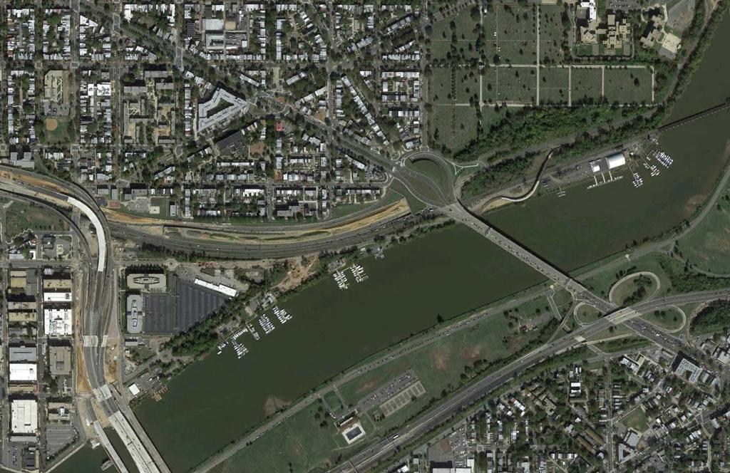
2 Existing Conditions Site Plan
3 CONGRESSIONAL CEMETERY SOUTHEAST BOULEVARD Planning Study Concept A (formerly A-1) Site Plan

4 Concept A (formerly A-1) Concept A proposes an expansion of the Capitol Hill neighborhood fabric, and street and block system. 13th, 14th, and 15th Streets SE are extended toward the Anacostia River, ending at a 4-lane boulevard north of the CSX right-of-way. Connections across the CSX tracks to the waterfront are provided for pedestrians and cyclists. NEW STREETS New 4-lane boulevard at L-Street SE elevation extends from 11th Street to Barney Circle. New boulevard integrates bike lanes and on-street parking. Grid streets extend south and connect to the new boulevard. L Street SE becomes double-sided with residential on both sides of the street. CONNECTIONS TO WATERFRONT Pedestrian connections across CSX tracks to Boathouse Row at 13th, 14th and 15th Streets SE. 13th Street SE connection could be a spiral ramp for pedestrians and cyclists. Allows connection across M Street to a future revitalized Virginia Avenue. 14th Street SE could connect to M Street SE and waterfront via pedestrian stairs and ramp. 15th Street SE could connect to a new park at Boathouse Row, implementing an element of the Boathouse Row Planning Study. LAND USES Moderate to medium density residential - predominantly multifamily and/or rowhouse. Potential for a small amount of new neighborhood commercial at ground floors of buildings along extension of 13th Street, SE close to Potomac Avenue SE and future revitalize Virginia Avenue SE. Potential for a small amount of new neighborhood commercial at ground floors of buildings along extension of 15th Street SE, close to commercial near Barney Circle. Potential future new park at Boathouse Row, in keeping with the Boathouse Row Planning Study. Potential for a future commercial or recreational building along M Street between 12th and 13th Streets. BUS PARKING Under-deck Commuter/ Tour Bus or Streetcar parking could potentially be located below the new boulevard right-of-way. Entry/ exit points for this parking area would be from 11th Street and/or Barney Circle only, ensuring vehicles do not circulate through the residential neighborhood. SOUTHEAST BOULEVARD Planning Study Concept A (formerly A-1) Concept Diagram and Site Section
 Interim")
5 CONGRESSIONAL CEMETERY SOUTHEAST BOULEVARD Planning Study Concept A (formerly A-1) Interim Site Plan
 Perspective View")
6 Concept A (formerly A-1) Perspective View 1
7 Concept A (formerly A-1) Perspective View 2
 Perspective View")
8 Concept A (formerly A-1) Perspective View 3
9 CONGRESSIONAL CEMETERY SOUTHEAST BOULEVARD Planning Study Concept B (formerly A-2) Site Plan

10 Concept B (formerly A-2) Concept B proposes an expansion of the Capitol Hill neighborhood fabric, and street and block system. 13th, 14th, and 15th and 16th Streets SE would be extended toward the Anacostia River, intersecting with a new 2-lane neighborhood street north of the CSX right-ofway. Connections across the CSX tracks to the waterfront would be provided for pedestrians and cyclists. NEW STREETS 2-lane neighborhood street at L-Street elevation extends from 11th Street SE to Barney Circle. New neighborhood street integrates bike lanes and onstreet parking. Grid streets extend south and connect to new neighborhood streets. L Street SE becomes double-sided with residential on both sides of the street. CONNECTIONS TO WATERFRONT Pedestrian connections across CSX tracks to Boathouse Row at 13th, 14th and 15th Streets SE. 13th Street SE connection could be a spiral ramp for pedestrians and cyclists. Allows connection across M Street SE to future revitalized Virginia Avenue SE. 14th Street SE could connect to M Street SE and waterfront via pedestrian stairs and ramp. 15th Street SE could connect to a new park at Boathouse Row, implementing an element of the Boathouse Row Planning Study. LAND USES Moderate to medium density residential - predominantly multifamily and/or rowhouse. Potential for a small amount of new neighborhood commercial at ground floors of buildings along extension of 13th Street SE, close to Potomac Avenue SE and future revitalized Virginia Avenue SE. Potential for a small amount of new neighborhood commercial at ground floors of buildings along extension of 15th Street SE, close to commercial near Barney Circle. Potential future new park at Boathouse Row, in keeping with the Boathouse Row Planning Study. Potential for a future building along M Street SE between 12th and 13th Streets SE. BUS PARKING Under-deck Commuter/ Tour Bus or Streetcar parking may not be possible with this concept due to narrowness of street right-of-way. SOUTHEAST BOULEVARD Planning Study Concept B (formerly A-2) Concept Diagram and Site Section
11 Concept B (formerly A-2) Perspective View 1
 Perspective View")
12 Concept B (formerly A-2) Perspective View 2
13 Concept B (formerly A-2) Perspective View 3
14 CONGRESSIONAL CEMETERY SOUTHEAST BOULEVARD Planning Study Concept C (formerly C-1) Site Plan


15 Concept C (formerly C-1) Concept C proposes a new a new neighborhood park between the Capitol HIll neighborhood to the north and the CSX right-of way. The four-lane boulevard would split around the park with two westbound lanes north of the park and two eastbound lanes south of the park. 13th, 14th, 15th and 16th Streets SE would be extended toward the Anacostia River, intersecting with the park and new roadways north of the CSX right-of-way. Connections across the CSX tracks to the waterfront would be provided for pedestrians and cyclists. NEW STREETS 4-lane boulevard extends from 11th Street SE to Barney Circle and splits around the new park with two westbound lanes north of the park and two eastbound lanes south of the park. Grid streets extend south and connect to new park and split boulevard. L Street SE would be separated from the new roadways and park by a tree-lined promenade. CONNECTIONS TO WATERFRONT Pedestrian connections across CSX tracks to Boathouse Row at 13th, 14th and 15th Streets SE. 13th Street SE connection could be a spiral ramp for pedestrians and cyclists. Allows connection across M Street to future revitalized Virginia Avenue. 14th Street SE could connect to M Street SE via pedestrian stairs and ramp. 15th Street SE could connect to a new park at Boathouse Row, implementing an element of the Boathouse Row Planning Study. LAND USES Predominant land use is park space. A small amount of residential infill could be located at the extention of 15th and L Streets SE. Potential future new park at Boathouse Row, in keeping with the Boathouse Row Planning Study. Potential for a future building along M Street between 12th and 13th Streets. BUS PARKING Under-deck Commuter/ Tour Bus or Streetcar parking could potentially be located below the new park and boulevard rights-of-way. Entry/ exit points for this parking area would be from 11th Street and/or Barney Circle only, ensuring vehicles do not circulate through the residential neighborhood. SOUTHEAST BOULEVARD Planning Study
16 Concept C (formerly C-1) Perspective View 1
17 Concept C (formerly C-1) Perspective View 2
18 Concept C (formerly C-1) Perspective View 3
19 Rendering Views

20 Concept A (formerly A-1) Perspective View for Render

21 Concept B (formerly A-2) Perspective View for Render

22 Concept C (formerly C-1) Perspective View for Render
NFTA Access Enhancement Study for Canalside and Cobblestone Alternatives Discussion. Alternative A South Park Avenue
 Alternative A South Park Avenue Alternative A Summary Alternative A extends Metro Rail service around the foot of Main Street east along South Park Avenue to serve a new station platform located along
DULLES AREA HIGHLIGHTS. Gary Garczynski Commonwealth Transportation Board Northern Virginia District. Committee for Dulles August 4, 2016
 DULLES AREA HIGHLIGHTS Gary Garczynski Commonwealth Transportation Board Northern Virginia District Committee for Dulles August 4, 2016 Smart Scale (formerly HB2) Overview Round 1 completed with the adoption
Lake Erie Commerce Center Traffic Analysis
 LOCATION: East of NYS Route 5 at Bayview Road Town of Hamburg Erie County, New York PREPARED BY: Wendel Companies 140 John James Audubon Parkway Suite 200 Amherst, New York 14228 January 2012 i ii Table
Union Station Queens Quay Transit Link Study
 Welcome Union Station in 1899. Image: City of Toronto Archives Union Station today. Image: Camil Rosiak Activity along Queens Quay. Image: Waterfront Toronto For more information or to comment, visit toronto.ca/waterfronttransit
Southwest LRT Alignment Video Narration
 Southwest LRT Alignment Video Narration September 2015 Southwest Light Rail Transit, a proposed extension of the METRO Green Line, will serve Minneapolis, St. Louis Park, Hopkins, Minnetonka and Eden Prairie.
STITCH TRANSFORMATIVE IDEA 3. SHORELINE STITCH. Re-connect the city to the waterfront and link the east and west Core Circle landscapes
 SHORE STITCH TRANSFORMATIVE IDEA 3. SHORELINE STITCH Re-connect the city to the waterfront and link the east and west Core Circle landscapes 126 LINE PUBLIC WORK 127 TRANSFORMATIVE IDEA 3. SHORELINE STITCH
Appendix 4.1 L. No-Build Project Descriptions
 Appendix 4.1 L No-Build Project Descriptions No-Build Projects New Bedford A new traffic signal system was installed and activated in early 2009 at the intersection of King s Highway and Mount Pleasant
DC Circulator Service Changes. Implementation Plan for June 24, 2018
 DC Circulator Service Changes Implementation Plan for June 24, 2018 Implementation Plan for June 24, 2018 Table of Contents 1.0 Overview of Service and Fare Changes... 5 1.1. Major Service Changes... 5
A VISION FOR EL MIRAGE
 el mirage A VISION FOR EL MIRAGE OASIS, ARIZONA A thriving desert jewel destination with a strong arts district, high-wage employment parks system joined together by cohesive, multi-use accessible trails
chapter - Hex Highway Touring Route Hamburg to Strausstown Overview
 chapter - 2 Hex Highway Touring Route Hamburg to Strausstown Overview The on-road Hex Highway automobile and bicycle touring route begins on State Street in downtown Hamburg. The route continues west on
Proposed Bicycle Lanes on Yonge Street from Queens Quay to Front Street
 STAFF REPORT ACTION REQUIRED Proposed Bicycle Lanes on Yonge Street from Queens Quay to Front Street Date: March 12, 2007 To: From: Toronto and East York Community Council Director, Transportation Infrastructure
Fuller/Fuller Heights Road Improvements
 Fuller/Fuller Heights Road Improvements Total Project Cost - $4.4M Project Description This project will construct a mini-roundabout at the intersection of Fuller Heights Road and Old Triangle Road to
Second Avenue: Union Street to Lenora Street, Condominium Owners c/o Michael McQuaid 1521 Second Avenue Seattle, WA 98101
 Second Avenue: Union Street to Lenora Street, Condominium Owners c/o Michael McQuaid 1521 Second Avenue Seattle, WA 98101 Subject: New Development - Cumulative Downtown Alley Traffic Congestion and Safety
Macleod Trail Corridor Study. Welcome. Macleod Trail Corridor Study Open House. Presentation of Proposed Design Concepts
 Macleod Trail Corridor Study Welcome Macleod Trail Corridor Study Open House Presentation of Proposed Design Concepts Study Purpose Develop a corridor plan for Macleod Trail that aligns with The City s:
SEVAN BARSEGHIAN'S PORTFOLIO GLENDALE COMMUNITY COLLEGE
 SEVAN BARSEGHIAN'S PORTFOLIO GLENDALE COMMUNITY COLLEGE SEVAN BARSEGHIAN EMAIL: SEVAN.BARSEGHIAN@YAHOO.COM PORTFOLIO DIRECTORY EDUCATION GLENDALE COMMUNITY COLLEGE, CA ARCHITECTURE PROGRAM (2011-2013)
MBTA WOLLASTON. Station Improvements Public Meeting. January 14, 2016
 MBTA WOLLASTON Station Improvements Public Meeting January 14, 2016 Kleinfelder, Inc. Architectural Engineers, Inc. Code Red Consultants, LLC Keville Enterprises, Inc. Vertical Transportation Excellence
All Groups. Conserve/
 All Groups Total stickers Large Open Small Multifamily Conserve/ Lot Space Lot Res Total Park Downtown 1 5 25 31 11 Fringe East 5 30 7 42 13 Fringe West 2 9 35 17 63 11 Rural Topsham 14.5 21.5 5 41 26
NEWS RELEASE. EL PASO DISTRICT Jennifer Wright (915) a TxDOT Project For immediate release
 a TxDOT Project For immediate release") NEWS RELEASE a TxDOT Project For immediate release EL PASO DISTRICT Jennifer Wright (915) 790-4340 Jennifer.Wright3@txdot.gov Major Operation: 36 massive beams will be placed at Sunland & I 10. Operation
NEWS RELEASE a TxDOT Project For immediate release EL PASO DISTRICT Jennifer Wright (915) 790-4340 Jennifer.Wright3@txdot.gov Major Operation: 36 massive beams will be placed at Sunland & I 10. Operation
Crystal City Station Improvements. Project Overview. Table 2: North Entrance. Table 1: South Entrance. 20th St. S 18th St. S.
 Table 1: South Entrance Table 2: North Entrance 20th St. S 18th St. S Proposed Second Entrance Crystal Drive Existing Station Location Platform Future 4 th Track Future New Airport Connection (by others)
FORT YORK PEDESTRIAN & CYCLE BRIDGE
 FORT YORK PEDESTRIAN & CYCLE BRIDGE November 2006 urban design landscape architecture architecture DTAH This is a new concept for the Fort York Pedestrian and Cycle Bridge linking Stanley Park (South)
TEMPE BEACH PARK - RECOMMENDATIONS
 TEMPE BEACH PARK - RECOMMENDATIONS Tempe Beach Park has the potential to become a regional destination park, but it suffers from a host of physical and operational problems, as well as structural flaws.
RW Bruhn Bridge and Approaches Project
 RW Bruhn Bridge and Approaches Project The Trans-Canada Highway 1 RW Bruhn Bridge and Approaches Project involves four-laning approximately 1.9 km of Highway 1 in Sicamous, including replacement of the
Aurora Hills. Getting There
 Aurora Hills Aurora Hills is neighborhood near Crystal City and Pentagon City. Ball fields, ball courts, a very short trail, and a combination ibrary/fire Station are the central pieces of a recreation
Appendix 1: Phase I Strategies
 Washington Metropolitan Area Transit Authority RTSP Presentation to the Technical Advisory Group January 19, 2012 Appendix 1: Phase I Strategies Base Case Definition MWCOG 2009 Adopted CLRP (2009-2030
gables station s dixie hwy & ponce de leon blvd coral gables, fl 33133
 Coral gables & SITE overview Gables Station is located in the beautiful city of Coral Gables, FL. The city is known for its tree-lined boulevards, ivy-covered mansions and historical landmarks such as
Figure 1: Little Dry Creek Trail Crossing
 Figure 1: Little Dry Creek Trail Crossing Figure 2: Little Dry Creek Trail Crossing Northwest Rail Environmental Evaluation Temporary Trail Detour Concurrence Form Adams County, Little Dry Creek Trail
TORONTO TRANSIT COMMISSION REPORT NO.
 Revised: March/13 TORONTO TRANSIT COMMISSION REPORT NO. MEETING DATE: March 26, 2014 SUBJECT: UNION PRECINCT STATUS REPORT UPDATE ON CONSTRUCTION INFORMATION ITEM RECOMMENDATION It is recommended that
TABLE OF CONTENTS. Coral Springs Charter High School and Middle School Job No Page 2
 Job No. 15-019 Page 2 TABLE OF CONTENTS 1.0 INTRODUCTION... 4 2.0 EXISTING CONDITIONS... 5 3.0 TRAFFIC GENERATION... 7 4.0 TRIP DISTRIBUTION... 8 5.0 FUTURE CONDITIONS... 8 6.0 SITE ACCESS...13 7.0 CONCLUSION...13
CHAPTER 1 TRANSIT MARKET AREAS AND EXISTING SERVICE
 CHAPTER 1 TRANSIT MARKET AREAS AND EXISTING SERVICE Transit Market Areas While several factors influence the propensity to use transit, the primary predictors of transit productivity are the density of
The Atlanta BeltLine. Project Overview Map
 The Atlanta BeltLine Project Overview Map The Atlanta BeltLine is a dynamic and transformative project for Atlanta. Through the development of a new transit system, multi-use trails, greenspace, and affordable
A retrospective look at work program counting activities since 2001 is found in Table 8, on the last page of this document. Hours of Operation
 Page 2 of 20 Background TPB staff has been managing data collection along the region s HOV facilities since the late 1990's, and documenting the results, which include counts of auto occupants, vehicles
Parking Amendments - Bay Street, between Harbour Street and Queens Quay West (York Street, Bay Street, and Yonge Street Ramp Removal)
") REPORT FOR ACTION between Harbour Street and Queens Quay West (York Street, Bay Street, and Yonge Street Ramp Removal) Date: October 26, 2017 To: Toronto and East York Community Council From: Acting Director,
REPORT FOR ACTION between Harbour Street and Queens Quay West (York Street, Bay Street, and Yonge Street Ramp Removal) Date: October 26, 2017 To: Toronto and East York Community Council From: Acting Director,
A. CONCLUSIONS OF THE FGEIS
 Chapter 11: Traffic and Parking A. CONCLUSIONS OF THE FGEIS The FGEIS found that the Approved Plan will generate a substantial volume of vehicular and pedestrian activity, including an estimated 1,300
Milestone: Bridge to Nowhere scheduled for demolition Aug 14
 NEWS RELEASE a TxDOT Project For immediate release EL PASO DISTRICT Blanca Del Valle (915) 790-4341 Blanca.DelValle@txdot.gov August 12, 16 Milestone: Bridge to Nowhere scheduled for demolition Aug 14
RETAIL POTENTIAL ON 1/2 ACRE SITE
 NO STANDING FEATURES: NEARBY: RETAIL POTENTIAL ON 1/2 ACRE SITE 20,000 SF ONE-STORY BUILDING ADJACENT TO NEWLY BUILT AUTOZONE CANARSIE - DIVISIONS AVAILABLE Building Dimensions: 200 x 100 Brooklyn Terminal
3. COLTA / HUGA CONNECTIONS - PRELIMINARY
 9 3. COLTA / HUGA CONNECTIONS - PRELIMINARY 3.1 COLTA The Chain of Lakes Trail Association (COLTA) trail, formerly identified as the Chester Spur Line, was completed and opened for use in June 2011. The
SWEDISH FIRST HILL MEDICAL CENTER
 SWEDISH FIRST HILL MEDICAL CENTER BLOCK 95 ALLEY VACATION / URBAN DESIGN MERIT JULY 16, 2015 CONTENTS INTRODUCTION NEIGHBORHOOD CONTEXT EXISTING CONDITIONS DESIGN COMPARISON 2 07 / INTRODUCTION 3 PROJECTS
Transportation TRANSPORTATION PROJECTS
 Transportation TRANSPORTATION PROJECTS Balls Ford Road Interchange Total Project Cost $142.9M This project includes the construction of a new diverging diamond interchange at Route 234 Bypass (Prince William
V. DATA COLLECTION PROGRAM
 V. DATA COLLECTION PROGRAM As discussed in Section IV, an extensive data assembly and data collection program was undertaken to develop the data necessary to calibrate the existing Portway Extensions model
I-579 Urban Open Space CAP Project. Final Land Development Plan (FLDP) Pittsburgh Department of City Planning
 Pittsburgh Department of City Planning") Final Land Development Plan (FLDP) I-579 Urban Open Space CAP Project Sports & Exhibition Authority (SEA) of the City of Pittsburgh and Allegheny County Project bounded by Chatham St. / Centre Ave. / Washington
Final Land Development Plan (FLDP) I-579 Urban Open Space CAP Project Sports & Exhibition Authority (SEA) of the City of Pittsburgh and Allegheny County Project bounded by Chatham St. / Centre Ave. / Washington
Springettsbury Township. Road Improvement Projects
 Springettsbury Township Road Improvement Projects 2009 2016 2016 Township Road Improvement Projects Springettsbury Township is divided into the following 4 Sectors: Northwest Sector Sherman Street Route
DRAFT TH AVE NE URBAN DESIGN MERIT PRESENTATION DPD# NOVEMBER 2017
 DRAFT 11.08.17 4801 24TH AVE NE URBAN DESIGN MERIT PRESENTATION 17-002 DPD#3027312 16 NOVEMBER 2017 PROJECT BACKGROUND URBAN DESIGN ANALYSIS VACATION / NO-VACATION COMPARISON URBAN DESIGN MERIT INTRODUCTION
UNION STATION ACCESS AND CAPACITY IMPROVEMENT STUDY PROJECT REPORT
 UNION STATION ACCESS AND CAPACITY IMPROVEMENT STUDY PROJECT REPORT Washington Metropolitan Area Transit Authority Department of Planning and Joint Development In Association with District of Columbia Department
NDG-Westmount Neighbourhood Committee. November 16, 2015
 NDG-Westmount Neighbourhood Committee November 16, 2015 2 Feedback on previous questions Order-in-Council 890-2010 - condition 8 The ministère des Transports must : Establish a buffer zone at the foot
FREDERICKSBURG DISTRICT. District Engineer Marcie Parker, P.E. May 8, 2018
 FREDERICKSBURG DISTRICT District Engineer Marcie Parker, P.E. May 8, 2018 3 Interstate 95 Projects Fredericksburg Area Fredericksburg region will see greatest degree of I-95 construction since widening
Section 106 Update Memo #1 Attachment D. Traffic Diversion & APE Expansion Methodology & Maps
 Section 106 Update Memo #1 Attachment D Traffic Diversion & APE Expansion Methodology & Maps I-65/I-70 North Split Interchange Reconstruction Project (Des. Nos. 1592385 & 1600808) Traffic Diversion and
DOWNTOWN BRT ALTERNATIVE - 19th AVE
 DOWNTOWN BRT ALTERNATIVE - 9th AVE New Route and Increased Service in Mixed Traffic Existing Route and Service in Mixed Traffic Light Rail Line / New Route and Increased in Exclusive Guideway Existing
I-70/I-71 Project Public Meeting Presented By
 I-70/I-71 Project Public Meeting Presented By Ohio Department of Transportation ms consultants, inc. engineers, architects, planners MSI Design June 9, 2010 W e l c o m e Thom Slack Planning Administrator,
// LEARN // ENGAGE // VOLUNTEER // DONATE // PROJECT OVERVIEW MAP
 // LEARN // ENGAGE // VOLUNTEER // DONATE // PROJECT OVERVIEW MAP PROJECT OVERVIEW MAP The Atlanta BeltLine is a dynamic and transformative project for Atlanta. Through the development of a new transit
York Street Pedestrian Promenade Plan, Front Street West to Queens Quay West
 STAFF REPORT ACTION REQUIRED York Street Pedestrian Promenade Plan, Front Street West to Queens Quay West Date: November 13, 2007 To: From: Wards: Reference Number: Toronto and East York Community Council
BOSTON, MA 171 TREMONT IMPACT ADVISORY GROUP 5/19/16
 BOSTON, MA 171 TREMONT IMPACT ADVISORY GROUP 5/19/16 171 Tremont will continue the transformation of Downtown Crossing into a revitalized neighborhood where all Bostonians can live, work, and play. 171
FDOT Treasure Coast Traffic Report through
 FDOT Treasure Coast Traffic Report 02 26 16 through 03 04 16 Kathleen Dempsey Fri 2/26/2016 2:56 PM To:Kathleen Dempsey ; 1 attachment 355 KB CR 714_Median Access Modifications.pdf;
SOUTHERN BELTWAY I-79 TO MON/FAYETTE EXPRESSWAY
 SOUTHERN BELTWAY I-79 TO MON/FAYETTE EXPRESSWAY Section 1 Purple Alternative (Revised: January 2007) I-79 to Mon/Fayette Expressway Purple Alternative Section 1 Photo Presentation Photo Presentation The
Williamsburg Town Hall Meeting
 Williamsburg Town Hall Meeting DEVELOPMENT UPDATE ORANGE COUNTY PLANNING DIVISION November 30, 2017 1 AREA CONTEXT FUTURE LAND USE MAP MEADOW WOODS MEADOW WOODS GINN PROPERTY ZONING MEADOW WOODS MEADOW
AGENCY NAME TRANSPORTATION
 TRANSPORTATION TRANSPORTATION AGENCY NAME Prince William County FY 2015 BUDGET CIP-TRANSPORTATION 561 Fuller Road/Fuller Heights Road Improvements Total Project Cost - $4.4 M This project will widen Fuller
San Pedro Waterfront Development Efforts Presentation for Trade, Commerce & Technology Committee
 San Pedro Waterfront Development Efforts Presentation for Trade, Commerce & Technology Committee November 17, 2015 Ports O Call Area Redevelopment Ports O Call Area Redevelopment Implementation Schedule
BICYCLE AND PEDESTRIAN COUNT PROGRAM 2016 Annual Report
 BICYCLE AND PEDESTRIAN COUNT PROGRAM 2016 Annual Report TABLE OF CONTENTS A Message from the Mayor... 4 Data Count Reports... 5 Count Locations... 6 Count Locations Map... 7 Trail Data... 8 International
Welcome to the Downtown Fort Lauderdale Neighborhood Working Group Meeting. First meeting june 17, 2010
 Welcome to the Downtown Fort Lauderdale Neighborhood Working Group Meeting First meeting june 17, 2010 State of the Project Draft Environmental Impact Statement Study Phase This study is NOT the final
CONTENTS. 1 Introduction Always Moving Forward while Building on the Past A Dynamic Destination... 5
 2010 STRUCTURE PLAN - 2 - CONTENTS 1 Introduction... 5 1.1 Always Moving Forward while Building on the Past... 5 1.2 A Dynamic Destination... 5 2 Map A... 6 Exhibition Place and its Neighbours... 7 3 Demonstration
Cell: (408) Release MA June 25, 2012
 Release MA June 25, 2012") VTA NEWS CONTACT: Bernice Alaniz FOR IMMEDIATE RELEASE Cell: (408) 888-9983 Release MA 12 06 08 Bernice.Alaniz@vta.org June 25, 2012 Construction Activities Underway For BART Silicon Valley The Santa Clara
VTA NEWS CONTACT: Bernice Alaniz FOR IMMEDIATE RELEASE Cell: (408) 888-9983 Release MA 12 06 08 Bernice.Alaniz@vta.org June 25, 2012 Construction Activities Underway For BART Silicon Valley The Santa Clara
M E S T I Z O C U R T I S P A R K
 ARAPAHOE CONNECTION TO BUS ROUTE AT ND AND LAWRENCE, FUTURE LIGHT RAIL STATION LEGEND SOCIAL TRAIL FLAGSTONE PAVING TO RESTORE/MAINTAIN CONCRETE PAVING DIAGONAL CURVILINEAR SOCIAL ROUTE IS OUT OF HISTORIC
LUDLAM TRAIL CORRIDOR DISTRICT
 1 APPLICATION NO. 9 MAY 2015 CDMP CYCLE LUDLAM TRAIL CORRIDOR DISTRICT PLANNING ADVISORY BOARD November 2, 2015 BACKGROUND 2 Staff Application Former Florida East Coast railroad corridor (privately owned)
HEARST GARDENS BERKELEY, CA 94702
 APPLICANT: RHOADES PLANNING GROUP 1611 TELEGRAPH AVE. SUITE 200 OAKLAND, CA 94612 [510] 545-4341 PROJECT: BERKELEY, CA 94702 ARCHITECT: DEVI DUTTA-CHOUDHURY, AIA DEVI DUTTA ARCHITECTURE INC. 1958A UNIVERSITY
Discovering the Trails of Prince George s County
 Discovering the Trails of Prince George s County Happy Trails! Since 2005, Wegmans has been partnering with town and city recreation programs and park conservancy groups to encourage folks to get moving
Site Location and Setting
 Memorandum Date: To: From: Subject: Kristy Le, Gary Black Steve Orem Santa Teresa County Park Historic Area Traffic and Parking Study Hexagon Transportation Consultants, Inc. has completed a traffic and
SR 934 Project Development And Environment (PD&E) Study
 Study") SR 934 Project Development And Environment (PD&E) Study Project Advisory Group Meeting March 1, 2018 State Road 934/NE/NW 79th Street from west of I-95 (NW 13th CT) to N. Bayshore Drive PD&E STUDY SR 934/NE/NW
SR 934 Project Development And Environment (PD&E) Study Project Advisory Group Meeting March 1, 2018 State Road 934/NE/NW 79th Street from west of I-95 (NW 13th CT) to N. Bayshore Drive PD&E STUDY SR 934/NE/NW
RARE STAND ALONE PAD WITH DRIVE-THRU ACCESSIBILITY ON
 RARE STAND ALONE PAD WITH DRIVE-THRU ACCESSIBILITY ON A v i a t i o n C r o s s i n g P r o p e r t i e s L i m i t e d the content the site the exposure the access the opportunity the design ARCHITECTURE
Survey Summary. 1. Overview. Pilot Implementation Survey Toronto Parks & Trails Wayfinding Strategy (Phase II) September 30 November 6, 2017
 September 30 November 6, 2017") Survey Summary Pilot Implementation Survey Toronto Parks & Trails Wayfinding Strategy (Phase II) September 30 November 6, 2017 1. Overview Between September 30 and November 6, 2017, the City of Toronto
Survey Summary Pilot Implementation Survey Toronto Parks & Trails Wayfinding Strategy (Phase II) September 30 November 6, 2017 1. Overview Between September 30 and November 6, 2017, the City of Toronto
DRAFT - APRIL 13, 2007 ROUTING STUDY FOR TRAIL CONNECTIONS BETWEEN CALAIS AND AYERS JUNCTION
 DRAFT - APRIL 13, 2007 ROUTING STUDY FOR TRAIL CONNECTIONS BETWEEN CALAIS AND AYERS JUNCTION Abstract The vision for the East Coast Greenway is an off-road urban trail system running from Calais, Maine
2.1 HISTORIC CONTEXT. View looking South from Main & 6th circa Typical logging scene with bullocks and skid road, 1885
 2.1 HISTORIC CONTEXT View looking North from Main & 7th circa 1889 View looking South from Main & 6th circa 1893 Typical logging scene with bullocks and skid road, 1885 The history of the Mt. Pleasant
Pattullo Bridge Replacement Project
 JULY 2018 PROJECT OVERVIEW Pattullo Bridge Replacement Project engage.gov.bc.ca/pattullobridge Artist s rendering of the proposed new Pattullo Bridge Pattullo Bridge Replacement Project 1 Priority Need
Northern Virginia District State of the District. Helen L. Cuervo, P.E. District Engineer October 18, 2017
 Northern Virginia District State of the District Helen L. Cuervo, P.E. District Engineer October 18, 2017 Susan Shaw, P.E., Megaprojects Director Virginia Department of Transportation American Society
Figure 1: Route 56B Hazelwood
 ROUTE 56B HAZELWOOD Route 56B is a radial route that operates on weekdays between Homestead and downtown Pittsburgh. Traveling inbound, the route begins in Homestead at the Waterfront shopping center,
Ossington Station Easier Access Project - Construction & Public Art Concept Update
 Ossington Station Easier Access Project Construction & Public Art Concept Update Open House College/Shaw Library 1 Easier Access Program Wide Committed to making all stations accessible by 2025 34 stations
FDOT Treasure Coast Traffic Impact Report October 9 through October 16, 2015
 From: Kathleen Dempsey To: Kathleen Dempsey Subject: FDOT Treasure Coast Traffic Report 10 09 15 through 10 16 15 Date: Friday, October 09, 2015 2:10:36 PM Attachments: image003.png CR 714_Median Construction
San Diego Convention Center Phase III Expansion. SDCCC Presentation to Mayor s Task Force June 2, 2009
 Expansion SDCCC Presentation to Mayor s Task Force June 2, 2009 Agenda The TSA/HNTB Team Experience and Lessons Learned Project Methodology Issues and Opportunities Alternative Masterplan Concepts Under
I-10 will close overnight Sunday through Thursday next week. Crews continue to make progress on Sunland s new bridges and ramps.
 NEWS RELEASE a TxDOT Project For immediate release EL PASO DISTRICT Rebecca Reyes (915) 790-4205 Rebecca.Reyes@txdot.gov I-10 will close overnight Sunday through Thursday next week. Crews continue to make
Northeast Anthony Henday Drive Edmonton Ring Road Update. Strathcona Chamber of Commerce March 18, 2015
 Northeast Anthony Henday Drive Edmonton Ring Road Update Strathcona Chamber of Commerce March 18, 2015 Project Background 2 Edmonton Ring Road Northwest opened Nov 2011 Northeast to open Oct 2016 Southwest
EXTERNAL COMMUNICATIONS TEAM MEETING MARCH 2015
 EXTERNAL COMMUNICATIONS TEAM MEETING MARCH 2015 1 SEGMENT 1 2 THE WISHBONE Connects the TEXpress Managed Toll System to the 35Express Managed Toll System Limits: Crown Road (near Royal Lane) to Valley
2018 NCFL Grand Nationals. Parking Information. This document contains the following:
 2018 NCFL Grand Nationals This document contains the following: Parking Information Hotel Specific Parking Information Union Station Parking Information Renaissance Parking Rates Washington D.C. Parking
Capitol Hill Prime Retail Space For Lease
 Capitol Hill Prime Retail Space For Lease,36-4,874 SF Billy Dean Poll, Altaras, CCIM CCIM + 45 + 45 586 586 5604 563 bpoll@nai-psp.com daltaras@nai-psp.com Billy Dean Poll, Altaras, CCIM CCIM + 45 + 586
ROUTE 630 DIVERGING DIAMOND INTERCHANGE
 ROUTE 630 DIVERGING DIAMOND INTERCHANGE Virginia Department of Transportation Contract Value and Dates Contract Value: $99,949,969.50 Start of Construction: Summer 2017 Final Completion Date: July 31,
Information Requests. Street Car Wildlife Golden Valley Leash Ordinance/Dog Park
 Information Requests Street Car Wildlife Golden Valley Leash Ordinance/Dog Park (How we got here!) 1980 Plan for Wirth Park (Designated Master Plan) Wirth Lake/Picnic Area designated as a general recreation
Treasure Island Supplemental Information Report Addendum
 1 1 1 1 0 1 0 1 0 1 Treasure Island Supplemental Information Report Addendum Introduction Purpose The purpose of this Supplemental Information Report (SIR) Addendum is to determine if the current land
PROCEEDING COMMENCED UNDER subsection 22(7) of the Planning Act, R.S.O. 1990, c. P.13, as amended
 of the Planning Act, R.S.O. 1990, c. P.13, as amended") DATE: January 13, 2018 CASE NO(S).: PL160942 PROCEEDING COMMENCED UNDER subsection 22(7) of the Planning Act, R.S.O. 1990, c. P.13, as amended Applicant and Appellant: Subject: Existing Designation: Proposed
DATE: January 13, 2018 CASE NO(S).: PL160942 PROCEEDING COMMENCED UNDER subsection 22(7) of the Planning Act, R.S.O. 1990, c. P.13, as amended Applicant and Appellant: Subject: Existing Designation: Proposed
Changes in TIP projects Draft vs. Final Draft
 Attachment 2 Dollars in $1,000 Key 08698 Franklin Road and Cloverdale Road Intersection Changes in TIP projects Draft vs. Final Draft RW - $1,314 UT - $1,000 CE - $341 CN - $3,675 CN - $499 09438 Caldwell
LANCASTER CORRIDOR REDEVELOPMENT ROSEDALE STREET REDESIGN PEACH STREET RAILROAD CROSSINGS
 LANCASTER CORRIDOR REDEVELOPMENT ROSEDALE STREET REDESIGN PEACH STREET RAILROAD CROSSINGS Presented at the SEE Development Excellence Workshop By Councilmember Wendy Davis, City of Fort Worth March 24,
April 4, 2014 Chuck McGinness, FDOT TREASURE COAST TRAFFIC REPORT April 4 through April 11, 2014
 April 4, 2014 Chuck McGinness, 954-777-4090 Chuck.McGinness@dot.state.fl.us FDOT TREASURE COAST TRAFFIC REPORT April 4 through April 11, 2014 TREASURE COAST Construction and maintenance-related lane closures
HARP AUTHORITY GATEWAY CENTER BOATHOUSE & CHANNEL EXTENSION TO SANTA FE AVENUE. Pueblo City Council Presentation September 17, 2018
 HARP AUTHORITY GATEWAY CENTER BOATHOUSE & CHANNEL EXTENSION TO SANTA FE AVENUE Pueblo City Council Presentation September 17, 2018 PROJECT: 1A HARP Expansion FUNDING 1A Ballot Issue Pueblo County : $3,000,000
St. Dennis Drive Conversion of Traffic Lanes to On- Street Parking and Bicycle Lanes
 STAFF REPORT ACTION REQUIRED St. Dennis Drive Conversion of Traffic s to On- Street Parking and Bicycle s Date: April 22, 2014 To: From: Wards: Reference Number: Public Works and Infrastructure Committee
Understanding Your I-66 Trip
 Understanding Your I-66 Trip DETERMINING YOUR TRIP Identify the location of your most convenient entrance and then follow the map to your exit. Pricing is tracked by four gantries along the corridor. Traffic
Spadina Avenue Built Form Study Preliminary Report
 STAFF REPORT ACTION REQUIRED Spadina Avenue Built Form Study Preliminary Report Date: July 9, 2014 To: From: Wards: Reference Number: Toronto and East York Community Council Director, Community Planning,
PORTS TORONTO Billy Bishop Toronto City Airport Summary of 2015 Traffic and Passenger Surveys
 PORTS TORONTO Billy Bishop Toronto City Airport Summary of 2015 Traffic and Passenger Surveys 1 Summary of 2015 BBTCA Traffic and Passenger Surveys Surveys of traffic volumes and pedestrian activity were
Pattullo Bridge Replacement Project
 FEBRUARY 2019 PROJECT OVERVIEW Pattullo Bridge Replacement Project engage.gov.bc.ca/pattullobridge Artist s rendering of the proposed new Pattullo Bridge Pattullo Bridge Replacement Project 1 Priority
Fairfax County Transportation Advisory Commission (TAC)
") Fairfax County Transportation Advisory Commission (TAC) January 17, 2017 Susan Shaw, P.E., Megaprojects Director Virginia Department of Transportation Amanda Baxter, Special Projects Development Manager
Fairfax County Transportation Advisory Commission (TAC) January 17, 2017 Susan Shaw, P.E., Megaprojects Director Virginia Department of Transportation Amanda Baxter, Special Projects Development Manager
3660 MARKET STREET, ST. LOUIS, MO armorydistrict.com
 3660 MARKET STREET, 1 REGIONAL CONTEXT PROPERTY INFORMATION One-of-a-kind creative/tech office redevelopment Over 160,000 SF of creative office space Mixed-use historic building High ceilings Next to the
I. Course venue: Preston Auditorium, 1818 H Street, N.W. Washington DC, 20433
 2017 OVERVIEW COURSE OF FINANCIAL SECTOR ISSUES Finance and Risk in a Global Environment June 19-23, 2017 World Bank Group, - Main Complex - Preston Auditorium 1818 H. Street, N.W. Washington, D.C. 20433
Pedestrian Safety Review Spadina Avenue
 STAFF REPORT ACTION REQUIRED Pedestrian Safety Review Spadina Avenue Date: October 13, 2015 To: Toronto and East York Community Council From: Director, Transportation Services, Toronto and East York District
5.1 Traffic and Transportation
 5.1 When it opens in 2009, the Bellevue Nickel Improvement Project will increase the number of vehicles able to travel through the study area, improve travel speeds, and improve safety by reducing the
CHAPTER 4 -- THE LAND USE PLAN: DESCRIPTIONS AND POLICIES FOR THIRTEEN PLANNING AREAS
 CHAPTER 4 -- THE LAND USE PLAN: DESCRIPTIONS AND POLICIES FOR THIRTEEN PLANNING AREAS NORTH CENTRAL CAC AREA LITTLE VALLEY ROAD TO JUG HANDLE CREEK PLANNING AREA This planning area includes Cleone, Noyo,