San Francisco, California Hunters Point Shipyard. Design for Development
|
|
|
- Dwain Jennings
- 6 years ago
- Views:
Transcription


1 San Francisco, California Hunters Point Shipyard Design for Development
2
3 San Francisco, California Hunters Point Shipyard Design for Development Adopted June 3, 2010 by: San Francisco Planning Commission Motion No San Francisco Redevelopment Commission Resolution No

4 Table of Contents 1 Introduction6 11 Summary of Document 12 Background 13 Site Location and Context 14 Access and Ownership 2 Vision18 21 Overall Concept 22 Goals and Objectives 23 Sustainability Design Principles 3 Proposed Plan48 31 Plan and Program 32 Public Streets 33 Public Parks and Open Space

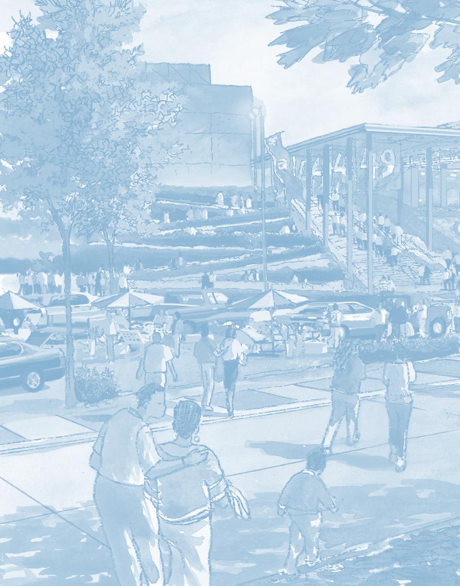
5 4 Land Use, Design Standards and Guidelines88 41 Land Use 42 Height, Bulk, and Massing 43 Building Design 44 Parking and Loading 45 Streetscape 5 Neighborhood Standards and Guidelines Shipyard North 52 Shipyard Village Center 53 Shipyard R&D 54 Shipyard South 6 Implementation Design Review Process 7 Appendix254
6 1

7 Introduction 11 Summary of Document 12 Background 13 Site Location and Context 14 Access and Ownership
8 2010 HUNTERS POINT SHIPYARD DESIGN FOR DEVELOPMENT 1 Introduction 11 Summary of Document This Design for Development (D4D) document establishes the development standards and guidelines that will govern all future design and development at Phase 2 of the Hunters Point Shipyard The D4D is the culmination of a multi-year community planning process References throughout this document to the Shipyard or the Shipyard site are to Phase 2 of the Hunters Point Shipyard, the boundaries of which are shown in Figure 11 On a macro-scale, the D4D is crafted to effectuate a specific urban form envisioned for the Shipyard; on a finer scale, it outlines specific design regulations created to inspire attractive building architecture and functional public spaces as this new neighborhood comes to life over the coming decades The Shipyard D4D document works in tandem with the D4D document for the adjacent Candlestick Point development project Taken together, the design regulations for both Project Areas aspire to fundamentally improve the built environment of southeast San Francisco The Shipyard site lies within the Hunters Point Shipyard Redevelopment Project Area The proposed development of the Shipyard has been set forth in the Hunters Point Shipyard Redevelopment Plan (the Plan), which has been amended to establish the allowable land uses for the Shipyard Thus, this Shipyard D4D is a companion document to, and authorized under, the Plan and has been adopted by the Redevelopment Agency of the City and County of San Francisco, the public agency responsible for oversight of development within the Hunters Point Shipyard Redevelopment Project Area The Plan, in general, provides a vision for the area that eliminates blight and environmental deficiencies while supporting market rate and affordable housing, economic development, small businesses, emerging commercial-industrial sectors, public transit service, publicly accessible open space and participation by residents in deciding the future of the area The design standards and guidelines contained in this D4D apply to all development within the Shipyard site area, including both the public and private realms, with the objective of implementing the vision set forth in both the Plan and in this document 8 section 1 - introduction
9 2010 HUNTERS POINT SHIPYARD DESIGN FOR DEVELOPMENT Companion Documents The Shipyard D4D addresses land use, building design, open space and street design in The Plan The D4D should be used in conjunction with a series of other companion documents that have been approved for the Hunters Point and Candlestick Point sites These documents include: Hunters Point Shipyard Redevelopment Plan Infrastructure Plan, Transportation Plan, Streetscape Plan, Signage Master Plan, Parks, Open Space and Habitat Plan, Sustainability Plan, and Design Review and Document Approval Procedure (DRDAP) Together, these documents supersede the San Francisco Planning Code in its entirety, except as otherwise provided for in the Hunters Point Shipyard Redevelopment Plan In the event of any conflict between this D4D and the Hunters Point Shipyard Redevelopment Plan, the Hunters Point Shipyard Redevelopment Plan shall control Development at Phase 1 of Hunters Point Shipyard, which corresponds to the adjacent Hunters Hill Residential District, is regulated by the Plan and the separate Design for Development for the Hunters Point Shipyard Redevelopment Project Panel, originally adopted in 1997 Organization This document has six sections as follows: 1 Introduction Provides a summary of the document, describes the general background to the Shipyard redevelopment, site location, context and current access and ownership 2 Vision Presents the overall concept, community goals and objectives, urban design principles and sustainability principles for the project These are described for both the Shipyard and Candlestick, since a consolidated plan has been prepared for these two areas to develop a mixed-use community with a connected street and transit network and a shared open space and trails system The overall vision provides the context for the Shipyard development plan, which is described in Section 3 The standards and guidelines that are specific to the Shipyard are located in Sections 4 and 5 3 Proposed Plan Describes the Shipyard s plan structure and program in terms of land uses, urban form, development program, the street network, and the parks and open space system section 1 - introduction 9
10 2010 HUNTERS POINT SHIPYARD DESIGN FOR DEVELOPMENT 4 Land Use, Design Standards and Guidelines Establishes the overall standards and guidelines that regulate the form and character of the development for elements that span across the Shipyard site These include land use height, bulk, massing, buildings, parking and loading, and streetscape Standards are mandatory actions, generally described in absolute terms such as by measurement or location Guidelines are encouraged actions, which if adhered to in spirit will result in projects that best fit the vision for the site 5 Neighborhood Standards and Guidelines There are four neighborhoods within the Shipyard site: Shipyard North Residential, Shipyard Research and Development (R&D), Shipyard Village Cultural Center, and Shipyard South Multi-Use A unique physical character is envisioned for each neighborhood and thus specific standards and guidelines are set forth for achieving the desired characteristics of such elements as at-grade retail, tower locations, street walls, mid-block breaks, and more For Shipyard South Multi-Use, both a stadium and two non-stadium options are described to address the uncertainty at time of writing whether the San Francisco 49ers will relocate to the Shipyard 6 Implementation Presents the required procedures for implementing development plans for the individual parcels, granting variances and amending this document The user of this D4D should be conscientious in cross-referencing sections of this D4D in cases where a design standard may be described in more than one section As organized, Section 4 provides design standards and guidelines universally applied throughout the Shipyard, while Section 5 will often provide more detailed or rigorous standards pertaining to a particular neighborhood within the Shipyard For example, the Shipyard site Street Wall requirements are contained in Section 423 However, more specific Street Wall requirements are proscribed in Section 523 for the Shipyard Village Center Option In summary, users should read and understand the D4D in its entirety before proceeding with design and related analyses of a particular parcel s development potential 10 section 1 - introduction
11 2010 HUNTERS POINT SHIPYARD DESIGN FOR DEVELOPMENT 12 Background The Shipyard and Candlestick Point (Candlestick) areas along the Bayview waterfront total 702 acres of land in the southeast portion of San Francisco Redevelopment of these two areas, which are largely underdeveloped and separated from the urban grid of the city, represents a rare opportunity to create an entirely new shoreline community within the Bayview Hunters Point community featuring: waterfront parks, a number of distinctive residential neighborhoods and a much needed injection of commercial and retail uses The combined project areas include: a decommissioned Naval Shipyard with dilapidated structures for ship repair, piers and dry-docks, and storage and administrative spaces; a number of former Navy buildings that are currently being used as artist studios and by light industrial tenants; the Candlestick Point State Recreation Area; an aging NFL stadium owned by the City and County and home to the San Francisco 49ers; and the Alice Griffith public housing development While the Shipyard and Candlestick are geographically distinct, their adjacency to one another has fostered a combined redevelopment planning effort resulting in a seamless community plan This plan establishes the vision for transforming this large land area from blight to new, thriving neighborhoods ringing San Francisco s southeastern waterfront Bayview residents have been long at work in establishing the overall vision and goals for revitalization for the Bayview Hunters Point area, which includes both of these sites, beginning with the 1969 Hunters Point Redevelopment Plan, the 1969 Indian Basin Industrial Park Redevelopment Plan, the 1995 South Bayshore Area Plan, the 1997 Hunters Point Shipyard Redevelopment Plan, and the 2006 Bayview Hunters Point Redevelopment Plan These goals include building a new home for the San Francisco 49ers, the development of job creating uses, improvement of existing parks, as well as tangible physical and economic benefits for the Bayview Hunters Point community, a long underserved and physically isolated part of San Francisco Now the City and the Bayview community have been afforded a unique chance to implement many of these goals Hence, an integrated plan has been prepared working with resident committees and with a developer partner section 1 - introduction 11


12 2010 HUNTERS POINT SHIPYARD DESIGN FOR DEVELOPMENT photo courtesy of Mark Defoe at The Shipyard Downtown San Francisco in background photo courtesy of Mark Defoe at The Shipyard Drydocks and piers in foreground, the Hunters Point Hilltop in background 12 section 1 - introduction


13 2010 HUNTERS POINT SHIPYARD DESIGN FOR DEVELOPMENT Candlestick State Recreation Area in foreground, stadium in mid-ground, Bayview Hill and Bayview neighborhood in background Candlestick State Recreation Area at left, stadium at center, Bayview Hill at right section 1 - introduction 13

14 2010 HUNTERS POINT SHIPYARD DESIGN FOR DEVELOPMENT 13 Site Location and Context City & County of San Francisco County of San Mateo Site Location The Shipyard and Candlestick project sites are located approximately five miles south of downtown San Francisco in the southeastern part of the city The total acreage of the two sites is approximately 702 acres As indicated on Figure 11, both sites have extensive shoreline frontage along the San Francisco Bay to the east and south, the South Basin and Yosemite Slough watershed which separates them, and India Basin to the north of the Shipyard Hunters Point Hill and the Bayview / Hunters Point neighborhood are located to the west of the Shipyard site; whereas the same neighborhood and Bayview Hill Park are adjacent to the north and west sides of the Candlestick Point site Bayview Hill Park creates a natural geographic limit to development and a buffer to Highway 101 to the west of the Candlestick site This City park has trails that overlook the entire Candlestick site and provide panoramic views of the Bay Part of Hunters Point Hill is currently being developed as both the Hilltop and Hillside Phase I developments of the Hunters Point Shipyard project The southeastern portion of the Hunters Point Hill is being developed as a park, which will link into the proposed Shipyard Phase II development The Shipyard is a former US Naval Shipyard, which was operational between World War II and 1974, and is currently accommodating some artist studios and light industrial uses on a portion of the site Candlestick is the current location of Candlestick Park (the home stadium of the San Francisco 49ers NFL team), the Candlestick Park State Recreation Area (CPSRA) and the Alice Griffith public housing development The Shipyard provided the major source of employment for the Bayview / Hunters Point neighborhood while it was operational Subsequent to its closure, economic opportunity has declined in this part of the city as the site has remained largely unused since Both the Shipyard and Candlestick projects will bring improved street and transit connections to the area, along with new employment uses that will substantially increase the community s economic activity To take advantage of this waterfront location, which provides the potential for some of the most significant open space area in the City, a major shoreline park will be created New public connections to the waterfront will be provided Further, a plan to restore the Yosemite Slough watershed, which feeds into the South Basin, will allow for an integrated park area to be created which extends from the CPSRA and includes the South Basin, Yosemite Slough and the southern shoreline of the Shipyard 14 section 1 - introduction

15 2010 HUNTERS POINT SHIPYARD DESIGN FOR DEVELOPMENT Figure 11 Site Context Highway 101 I 280 Third Street Hunters Point Shipyard Candlestick Point Legend 1 Bayshore Caltrain Station 2 Bayview Hill Park 3 Hunters Point Shipyard Phase I Hilltop and Hillside 4 Bayview Neighborhood 5 Bayview Industrial Lands 6 India Basin 7 Candlestick Park Stadium 8 Re-gunning Crane 9 South Basin 10 Yosemite Slough Watershed 11 San Francisco Bay 0 1/4 1/2 1mi section 1 - introduction 15


16 2010 HUNTERS POINT SHIPYARD DESIGN FOR DEVELOPMENT 14 Shipyard Access and Ownership The Shipyard site is shown in Figure 12 Building 101 Access to the site is primarily from Innes Avenue on the east side of the Hillside, and Palou Avenue on the west Only two streets on the Hillside connect to the Shipyard due to topographical constraints; these are Donahue Street and Horne Avenue Currently, the site is home to the decommissioned Hunters Point Shipyard Naval Base The Navy is in the final stages of cleaning and then vacating the site An active artist s community known as The Point consisting of some 250+ artists also occupies the site with studios in a number of naval base buildings including building 101, 103, 104 and 110 Drydock 4 at the Shipyard Buildings 204, 205, and 207 Immediately north of the Shipyard site, Hunters Point Shipyard Phase I is currently being constructed This project has two separate areas: Hilltop and Hillside Collectively, they will contain approximately 1,600 homes and 9,000 sq ft of retail space Connections from Phase II to Phase I will be made primarily by pedestrian paths due to topographical constraints and by the extension of Horne Avenue State Trust will have jurisdiction over lands as identified in Figure 12 Land Uses in these areas must be for the benefit of the general public and may include park spaces, paths, public roads, public buildings such as restaurants or ferry buildings, and other uses that allow unrestricted public access Streets that lie within Trust Lands include Lockwood, Horne and Fischer Drydock 4 Naval Crane 16 section 1 - introduction

 Submerged Lands subject to the Public Trust upon completion of the Exchange section 1 -")
17 2010 HUNTERS POINT SHIPYARD DESIGN FOR DEVELOPMENT Figure 12 af Av ra St e Av e ve ve t Lennar Urban za St rs ve e e l ve od he aa re te e Av Av wo sc ve Hunters Point Hillside od Ga ck Cris p Rd Ar el io us W al Sh ad ld Lo Fi Re Av ve rro e e es u ea wo rn Qu lo rk Av Ho Pa al Ki ve Je Dr kd on e Kiska Rd sa ke r Oa g e R d ds hu Nort hrid ne na In Do Hu Access and Ownership US Navy South Basin ,000 2,000' Legend Property Boundaries State Trust Lands (Proposed) Submerged Lands subject to the Public Trust upon completion of the Exchange section 1 - introduction 17
M E M O R A N D U M. Status of the Environmental Cleanup of the Shipyard
 ECONOMIC AND WORKFORCE DEVELOPMENT MICHAEL COHEN, DIRECTOR CITY AND COUNTY OF SAN FRANCISCO GAVIN NEWSOM, MAYOR M E M O R A N D U M TO: Members of the Health Commission FROM: Michael Cohen CC: Mitch Katz,
North Forty Area ( area bounded by Lark Avenue, Los Gatos Boulevard, Highway 85 and
 RESOLUTION 2015-056 RESOLUTION OF THE TOWN COUNCIL OF THE TOWN OF LOS GATOS ADOPTING GENERAL PLAN AMENDMENTS NECESSARY FOR THE NORTH FORTY SPECIFIC PLAN. THE PLAN AREA COMPRISES APPROXIMATELY 44 ACRES
ARLINGTON COUNTY, VIRGINIA
 ARLINGTON COUNTY, VIRGINIA County Board Agenda Item Meeting of April 16, 2005 DATE: March 28, 2005 SUBJECTS: A. Adoption of the Fort Myer Heights North Plan. B. GP-300-04-1 Adoption of the following General
Spadina Avenue Built Form Study Preliminary Report
 STAFF REPORT ACTION REQUIRED Spadina Avenue Built Form Study Preliminary Report Date: July 9, 2014 To: From: Wards: Reference Number: Toronto and East York Community Council Director, Community Planning,
Bloor Street West Rezoning Application for a Temporary Use By-law Final Report
 STAFF REPORT ACTION REQUIRED 3741 3751 Bloor Street West Rezoning Application for a Temporary Use By-law Final Report Date: June 12, 2007 To: From: Wards: Reference Number: Etobicoke York Community Council
Part Three : COMMUNITY PLAN AREAS AND SPECIAL STUDY AREAS SACRAMENTO 2030 GENERAL PLAN. Introduction
 Special study Areas Part Three : COMMUNITY PLAN AREAS AND SPECIAL STUDY AREAS SACRAMENTO 2030 GENERAL PLAN Introduction Beyond the boundaries of the 2030 General Plan, the City has defined Special Study
CHULA VISTA DEVELOPMENT OPPORTUNITY. For Additional Information: Sean Bascom Lic#
 CHULA VISTA DEVELOPMENT OPPORTUNITY For Additional Information: Sean Bascom 619.916.9179 bascom@scc1031.com Lic# 01862044 Image TAVA Third Avenue Village is the heart of Chula Vista s historic downtown.
KAP Lot 3. Lot 3. Lot Lot 5. Lot 6. Lot 7. Lot 8. Lot KAP 81153
 Public Notice April 26, 2018 Subject Property: 249 Westminster Ave W Lot A, District Lot 4, Group 7, Similkameen Division Yale (Formerly Yale Lytton) District, KAP92015 Application: Rezone PL2018-8201
CHULA VISTA DEVELOPMENT OPPORTUNITY. For Additional Information: Sean Bascom Lic#
 For Additional Information: Sean Bascom 619.916.9179 bascom@scc1031.com Lic# 01862044 CHULA VISTA DEVELOPMENT OPPORTUNITY Excellent Location Near Vibrant Third Avenue Village High Density Zoning Building
230 CHURCH AVENUE CHULA VISTA, CA 91910
 Excellent Location Near Vibrant Third Avenue Village High Density Zoning Building Height up to 45 Lot size of 11,326 sqft Flat/Graded Lot Ease of Access to Utility Hookups Multiple Allowed Uses For Additional
CHURCH AVENUE CHULA VISTA, CA 91910
 For Additional Information: Sean Bascom 619.916.9179 bascom@scc1031.com Lic# 01862044 CHURCH AVENUE CHULA VISTA, CA 91910 CHULA VISTA DEVELOPMENT OPPORTUNITY Excellent Location Near Vibrant Third Avenue
Airport Planning Area
 PLANNING AREA POLICIES l AIRPORT Airport Planning Area LOCATION AND CONTEXT The Airport Planning Area ( Airport area ) is a key part of Boise s economy and transportation network; it features a multi-purpose
Chapter 1: Introduction
 Chapter 1: Purpose of the Comprehensive Plan The purpose of the Comprehensive Plan of the City of Rockaway Beach is to provide a policy guide for the growth and future development of the City. Section
Financing Pier 70 Waterfront District Development Plan upon Board of Supervisors Approval
 Financing Pier 70 Waterfront District Development Plan upon Board of Supervisors Approval D Proposition D Shall the City provide funds to develop Pier 70, based on new City hotel and payroll expense tax
Napa County Planning Commission Board Agenda Letter
 Agenda Date: 7/20/2011 Agenda Placement: 10A Napa County Planning Commission Board Agenda Letter TO: FROM: Napa County Planning Commission Hillary Gitelman - Director Conservation, Development & Planning
Executive Summary Downtown Park Fund Allocation HEARING DATE: MAY 5, 2016
 Executive Summary Downtown Park Fund Allocation HEARING DATE: MAY 5, 2016 Date: April 28, 2016 Case No.: 2016 004634CWP Project Name: Allocation of $4,000,000 from the Downtown Park Fund for the Renovation
Town of Markham Yonge and Steeles Corridor Study and City of Vaughan Yonge Street Area Study
 STAFF REPORT ACTION REQUIRED Town of Markham Yonge and Steeles Corridor Study and City of Vaughan Yonge Street Area Study Date: August 14, 2009 To: From: Wards: Reference Number: North York Community Council
EXHIBIT 1. BOARD AUTHORIZATION FOR PUBLIC HEARING AND SUBSEQUENT ISSUANCE OF A JOINT DEVELOPMENT SOLICITATION
 EXHIBIT 1. BOARD AUTHORIZATION FOR PUBLIC HEARING AND SUBSEQUENT ISSUANCE OF A JOINT DEVELOPMENT SOLICITATION Washington Metropolitan Area Transit Authority Board Action/Information Summary @Action O Information
Section II. Planning & Public Process Planning for the Baker/Carver Regional Trail began in 2010 as a City of Minnetrista initiative.
 Section II Planning & Public Process Planning for the began in 2010 as a City of initiative. city staff began discussions with the Park District on the possibility of a north/south regional trail connection
Huntington Metro Station Joint Development
 Finance and Capital Committee Information Item II-C September 13, 2018 Huntington Metro Station Joint Development Page 120 of 284 Washington Metropolitan Area Transit Authority Board Action/Information
MAP AMENDMENT/HEIGHT MAP AMENDMENT SUMMARY. Three stories above River Street Two stories above River Street
 MPC STAFF REPORT TEXT AMENDMENT Historic District Height Map MAP AMENDMENT/HEIGHT MAP AMENDMENT SUMMARY Report Status Initial Report- Petitioner, Property Owner, Agent Information SRD, LLC d/b/a The Kessler
401, and 415 King Street West - Zoning Amendment Application - Preliminary Report
 STAFF REPORT ACTION REQUIRED 401, 407-409 and 415 King Street West - Zoning Amendment Application - Preliminary Report Date: January 27, 2011 To: From: Wards: Reference Number: Toronto and East York Community
CITY PLANNING COMMISSION AGENDA ITEM NOS: 5.A, 5.B STAFF: MICHAEL SCHULTZ
 CPC Agenda Page 83 CITY PLANNING COMMISSION AGENDA ITEM NOS: 5.A, 5.B STAFF: MICHAEL SCHULTZ FILE NO(S): CPC DP 03-00259-A5MN11 QUASI-JUDICIAL AR NV 11-00538 QUASI-JUDICIAL PROJECT: BROADMOOR TEMPORARY
Classifications, Inventory and Level of Service
 Classifications, Inventory and Level of Service Section 3 Kenmore Park, Recreation and Open Space Plan 1 P a g e Classifications and Inventory Park Classifications Kenmore classifies its parks based upon
Toronto and East York Community Council. Acting Director, Community Planning, Toronto and East York District
 STAFF REPORT ACTION REQUIRED 440, 444, 450 and 462 Front Street West; 425, 439, 441 and 443 Wellington Street West; 6-18 Spadina Ave. and 1 and 19 Draper Street Urban Design Guidelines Final Report Date:
LAND USE GUIDELINES NEW TOWN
 VI LAND USE A L T ETruRck TNraiAl T I V E S AarNnelDla D E S I G N W GUIDELINES NEW TOWN ad Ro DAVEN CA LF IRE ALTERNATIVE LAND USE PLANS AND DESIGN GUIDELINES - VI VI LAND USE ALTERNATIVES Asilomar Hotel
CONTENTS. 1 Introduction Always Moving Forward while Building on the Past A Dynamic Destination... 5
 2010 STRUCTURE PLAN - 2 - CONTENTS 1 Introduction... 5 1.1 Always Moving Forward while Building on the Past... 5 1.2 A Dynamic Destination... 5 2 Map A... 6 Exhibition Place and its Neighbours... 7 3 Demonstration
Martinez General Plan 2035 White Paper TRAILS
 Martinez General Plan 2035 White Paper TRAILS November 2016 The Issue The draft Martinez General Plan 2035 and Draft Program Environmental Impact Report were released for public review on September 15,
CITY RAIL LINK. New Public Transport Stations and Development Opportunities at Karangahape Road, Newton and Aotea Quarter
 134 AC_BEU_CCMP_3_TM5_8_FD.indd 134 20/07/12 12:30 PM 05 CITY RAIL LINK New Public Transport Stations and Development Opportunities at Karangahape Road, Newton and Aotea Quarter 5 MO VE 0 1 2 8 KEY 1 Britomart
VICTORIA QUAY COMMERCIAL PRECINCT PLAN
 VICTORIA QUAY COMMERCIAL RECINCT LAN AUGUST 2014 2.0 Introduction 10 2.0 INTRODUCTION 2.1 The role of an Enabling recinct lan A recinct lan provides a clear assessment framework for development. in relation
Overview Parks Alliance Overview March 2017
 Overview Our Mission The mission of the San Francisco Parks Alliance is to inspire and promote civic engagement and philanthropy to protect, sustain and enrich San Francisco parks, recreation and green
Director, Community Planning, Toronto and East York District
 STAFF REPORT October 25, 2005 To: From: : Subject: Toronto and East York Community Council Director, Community Planning, Toronto and East York District Status Report OPA & Rezoning Application 05 117524
Northwest Triangle. Redevelopment Proposal. Property Acquisition, Engineering, and Demolition. December, 2005 REDEVELOPMENT AUTHORITY OF THE
 Northwest Triangle Redevelopment Proposal Property Acquisition, Engineering, and Demolition December, 2005 REDEVELOPMENT AUTHORITY OF THE CITY OF YORK York City Redevelopment Authority 14 West Market Street,
The Atlanta BeltLine. & Sustainable Development GAFM Conferance. // March 25, 2014
 The Atlanta BeltLine & Sustainable Development GAFM Conferance // March 25, 2014 04/22/2014 Atlanta BeltLine // 2013 Page 1 // Organizational Structure Project Owner and Sponsor Redevelopment Authority
2433 Dufferin Street Zoning By-law Amendment Application - Preliminary Report
 STAFF REPORT ACTION REQUIRED 2433 Dufferin Street Zoning By-law Amendment Application - Preliminary Report Date: July 22, 2014 To: From: Wards: Reference Number: North York Community Council Director,
Fort Myers Downtown & Riverfront Redevelopment
 Fort Myers Downtown & Riverfront Redevelopment Brought to you by the Fort Myers Community Redevelopment Agency (CRA) Fort Myers Community Redevelopment Agency The Fort Myers Community Redevelopment Agency
Development Agreement No. DA16-002
 STAFF REPORT Planning Commission AGENDA ITEM NUMBER 5 MEETING DATE April 13, 2016 CASE NUMBER PROPERTY OWNER PROJECT PROPONENTS City of Buena Park as Successor Agency to the former Community Redevelopment
 www.millenniumpalmdesert.net Palm Desert, California C IFI C INT ERS Pla LOCATION...LOCATION...LOCATION!! Centrally located to the entire Coachella Valley Quick access to Palm Springs International Airport,
Chair and Members of Harbour East - Marine Drive Community Council. Brad Anguish, Director, Parks and Recreation
 P.O. Box 1749 Halifax, Nova Scotia B3J 3A5 Canada Item No. 15.1.1 Harbour East-Marine Drive Community Council December 3, 2015 TO: SUBMITTED BY: Chair and Members of Harbour East - Marine Drive Community
NAVAJO COMMUNITY PLAN
 NAVAJO COMMUNITY PLAN Prepared by the NAVAJO COMMUNITY PLANNERS and THE CITY OF SAN DIEGO City of San Diego Planning Department 202 C Street, MS 4A San Diego, CA 92101 Printed on recycled paper. This information,
Analysis of Zoning for Prototype Development Projects in Yamhill County
 March 3, 2009 To: cc: From: Re: Clark Worth Eric Hovee Bruce Prenguber John Spencer Analysis of Zoning for Prototype Development Projects in Yamhill County INTRODUCTION The purpose of this memo is to determine
Establishing a National Urban Park in the Rouge Valley
 STAFF REPORT ACTION REQUIRED Establishing a National Urban Park in the Rouge Valley Date: March 29, 2012 To: From: Wards: Reference Number: Executive Committee Deputy City Manager, Cluster B All p:\2012\cluster
Clackamas County Development Agency
 Clackamas County Development Agency Development Services Building, 150 Beavercreek Rd., Oregon City, OR 97045 www.clackamas.us/transportation/renewal 503-742-4323 The Clackamas County Board of Commissioners
st Street. Astoria Queens, New York. Offering Memorandum
 Astoria Queens, New York Offering Memorandum or implied, as to the accuracy of the information. References to square footage or age are approximate. Buyer must verify the information and bears all risk
NEWBORO AND PORTLAND HARBOUR REDVELOPMENT PLANS
 INTRODUCTION The Municipal docks in both Newboro and Portland were transferred to the Township of Rideau Lakes by Parks Canada in 2002. Little has been done to improve the docks physical condition or role
LA Waterfront Public Sites Opportunity Analysis IGTCT Committee Meeting
 LA Waterfront Public Sites Opportunity Analysis IGTCT Committee Meeting Economic & Planning Systems, Inc. (EPS) Oakland Denver Los Angeles Sacramento February 21, 2017 Economic & Planning Systems, Inc.
RETAIL POTENTIAL ON 1/2 ACRE SITE
 NO STANDING FEATURES: NEARBY: RETAIL POTENTIAL ON 1/2 ACRE SITE 20,000 SF ONE-STORY BUILDING ADJACENT TO NEWLY BUILT AUTOZONE CANARSIE - DIVISIONS AVAILABLE Building Dimensions: 200 x 100 Brooklyn Terminal
Memorandum. Fund Allocation Fund Programming Policy/Legislation Plan/Study Capital Project Oversight/Delivery Budget/Finance Contract/Agreement Other:
 Memorandum Date: March 23, 2018 To: Transportation Authority Board From: Eric Cordoba Deputy Director Capital Projects Subject: 4/10/18 Board Meeting: San Francisco Freeway Corridor Management Study Update
Downtown Design Guidelines. Background
 Downtown Design Guidelines Background City of Boulder November, 2006 Downtown Design Guidelines Background Pearl Street Pedestrian Mall in 1977 City of Boulder November, 2006 Downtown Design Guidelines
Everett Riverwalk Life style explore
 Life style explore Project Overview The 217-acre Everett Riverfront redevelopment is visible from I-5 with traffic counts charted at 170,000+ vehicles per day with direct freeway access from 4-way interchange.
Port of San Diego Overview and Updates. September 2017
 Port of San Diego Overview and Updates September 2017 Port of San Diego Jurisdiction 34 miles of waterfront 2,403 acres of land 3,535 acres of water Port Tidelands Coronado San Diego National City Chula
Home of Southbank Partners. Riverfront Commons. Southbank Partners. Covington Newport Bellevue Ft. Thomas Dayton Ludlow
 Home of Southbank Partners Riverfront Commons Southbank Partners Covington Newport Bellevue Ft. Thomas Dayton Ludlow Riverfront Commons Fostering a vision of Northern Kentucky s Future Riverfront Commons
URBAN DESIGN REPORT. Proposed Residential Development, Old Church Road, Caledon East
 Proposed Residential Development, Old Church Road, Caledon East TABLE CONTENTS: 1.0 DEVELOPMENT 1.1 Introduction-Analysis of Guiding Principles and Documents 1.2 Community Design and Architectural Design
Slide 1. Waterfront Plan Land Use Subcommittee. Port Seawall Lots
 Slide 1 Waterfront Plan Land Use Subcommittee Port Seawall Lots June 7, 2017 Slide 2 Discussion of Seawall Lots 1 Brief history on North of China Basin seawall lots 2 Waterfront Plan Use policies and current
S i t e A n a ly s i s
 S i t e A n a ly s i s 11 SECTION B SITE ANALYSIS Existing Conditions TRANSPORTATION CONTEXT: The Ohlone Greenway site, paralleling San Pablo Avenue to the west, is centrally located within the City of
DRAFT GENERAL IMPLEMENTATION PLAN AND SPECIFIC IMPLEMENTATION PLAN MIDDLETON MUNICIPAL AIRPORT MOREY FIELD. Revised 12/12/03
 DRAFT GENERAL IMPLEMENTATION PLAN AND SPECIFIC IMPLEMENTATION PLAN MIDDLETON MUNICIPAL AIRPORT MOREY FIELD Revised 12/12/03 As recommended for approval by the Plan Commission General Project Description
Madison Metro Transit System
 Madison Metro Transit System 1101 East Washington Avenue Madison, Wisconsin, 53703 Administrative Office: 608 266 4904 Fax: 608 267 8778 TO: FROM: SUBJECT: Plan Commission Timothy Sobota, Transit Planner,
DRAFT TH AVE NE URBAN DESIGN MERIT PRESENTATION DPD# NOVEMBER 2017
 DRAFT 11.08.17 4801 24TH AVE NE URBAN DESIGN MERIT PRESENTATION 17-002 DPD#3027312 16 NOVEMBER 2017 PROJECT BACKGROUND URBAN DESIGN ANALYSIS VACATION / NO-VACATION COMPARISON URBAN DESIGN MERIT INTRODUCTION
Washington Township MASTER PLAN. Addendum: Washington Township Master Plan
 Washington Township MASTER PLAN Addendum: Washington Township Master Plan CHAPTER XI RECREATION CORE DISTRICT Introduction The Recreation Core District generally encompasses the areas north of 30 Mile
COASTAL CONSERVANCY. Staff Recommendation November 6, 2008 SAN FRANCISCO BAY TRAIL: CANAL BOULEVARD CONSTRUCTION
 COASTAL CONSERVANCY Staff Recommendation November 6, 2008 SAN FRANCISCO BAY TRAIL: CANAL BOULEVARD CONSTRUCTION File No. 07-037-02 Project Manager: Michelle Jesperson RECOMMENDED ACTION: Authorization
6. How connected do you feel to the Sans Souci community?
 Please complete and return before May 1st, 2017, to be entered for a prize drawing. Further instructions are available on the last page. Digital version available at GCPlanning.org. 1. Do you live and/or
River First Initiative and Waterworks Park
 River First Initiative and Waterworks Park The RiverFIRST proposal is critical to the creation of a larger regional parks and trails network, as well as ecological and infrastructure system. When realized,
Date: 11 th January, From: Plaistow & Ifold Parish Neighbourhood Plan - Steering Group. Plaistow & Ifold Parish Council
 Date: 11 th January, 2017 From: Plaistow & Ifold Parish Neighbourhood Plan - Steering Group To: Plaistow & Ifold Parish Council Re: Neighbourhood Plan Report to Parish Council Meeting 17 Jan 2017 The Steering
REGIONAL BOARD REPORT
 REGIONAL BOARD REPORT Administrator s Office For the Board August 21, 2008 DATE: August 14, 2008 FILE NOS.: A-07-06377/8/9.000 FROM: RE: Chief Administrative Officer OCP and Zoning Amendment Application
Alternative Highest & Best Use Analysis Boutique Hotel
 Alternative Highest & Best Use Analysis In response to numerous comments received from the public, as well as issues raised by the CCC in the Appeal Staff Report Substantial Issue Determination, the following
City of College Park s Update to the Zoning Ordinance
 Comparison table for the City s Zoning Ordinance Residential s R-1 Single Family R-2 Single Family Single family uses 24,000 sq ft lot size 90 ft lot width Front 60 ft Side 15 ft Rear 40 ft Minimum floor
COLLEGE STREET STUDY Community Consultation Meeting. December 2015
 COLLEGE STREET STUDY Community Consultation Meeting December 2015 2 Agenda 6:30 pm Introductions, Agenda Review and Welcome 6:40 pm Presentation Planning Recommendations 7:30 pm Questions and Discussion
FACT SHEET HUNTERS POINT SHIPYARD Parcel E-2 PCB Hot Spot Time-Critical Removal Action: 2010
 FACT SHEET HUNTERS POINT SHIPYARD Parcel E-2 PCB Hot Spot Time-Critical Removal Action: 2010 Shoreline Hot Spot Area Central Portion - View North October 2009 This fact sheet provides information about
Appendix L Technical Memorandum Aesthetics
 Technical Memorandum Aesthetics 1.0 AESTHETICS This section provides a discussion of the aesthetic resources in the vicinity of ARTIC. Aesthetics pertain to the elements that make a certain view pleasing
LUDLAM TRAIL CORRIDOR DISTRICT
 1 APPLICATION NO. 9 MAY 2015 CDMP CYCLE LUDLAM TRAIL CORRIDOR DISTRICT PLANNING ADVISORY BOARD November 2, 2015 BACKGROUND 2 Staff Application Former Florida East Coast railroad corridor (privately owned)
CHAPTER 3 PLANNING GOALS
 CHAPTER 3 PLANNING GOALS AND PUBLIC INPUT INTRODUCTION This portion of the Algonac Master Plan is intended to outline a course for action in achieving the community s vision for the future. Throughout
13.1 REGIONAL TOURISM ISSUES AND SUMMARY OF FINDINGS
 13 REGIONAL TOURISM T he County of Mariposa s recreation needs and facilities fall within two categories: regional tourism and local recreation. This Element focuses on regional tourism issues related
Welcome to our exhibition
 Welcome to our exhibition We are bringing forward a new, employment-led scheme for the Vauxhall Cross Island site in the heart of Vauxhall. We are keen to hear local views on our proposals ahead of submitting
CLEVELAND PARK LOCATION AND HISTORY EXISTING CONDITIONS AND CHARACTER LOCATION
 CLEVELAND PARK LOCATION LOCATION AND HISTORY Attempts to create a neighborhood park and playground in the Cleveland neighborhood began in 1926, when the park board designated for acquisition the block
Changing Lanes. Click to edit Master title style. Toronto and East York Community Council. Second level Third level. Fourth level.
 Changing Lanes Toronto s Click to Laneway edit Master Suites text Strategy styles Toronto and East York Community Council May 2, 2018 2,433 Total number of Laneways in the City of Toronto 295 km Of Laneways
Heritage Character Area Zoning - Edmonton s Approach to Preserving(?) Community Character
 Community Character") Heritage Character Area Zoning - Edmonton s Approach to Preserving(?) Community Character Federation of Calgary Communities Community Planning Exchange November 4, 2017 City of Edmonton CITY
Heritage Character Area Zoning - Edmonton s Approach to Preserving(?) Community Character Federation of Calgary Communities Community Planning Exchange November 4, 2017 City of Edmonton CITY
ANCLOTE COASTAL TRAIL ALTERNATIVES ANALYSIS STUDY
 ANCLOTE COASTAL TRAIL ALTERNATIVES ANALYSIS STUDY PASCO COUNTY MPO JULY 2015 PROJECT OVERVIEW... INTRODUCTION EXECUTIVE SUMMARY CONTEXT... TAMPA BAY AREA, PINELLAS, & PASCO COUNTY S MULTI-USE TRAIL PLANS
CORNWALL WATERFRONT PLAN 2007
 CANAL LANDS CANAL LANDS Page 58 Introduction This chapter details areas of possible development or redevelopment, and lands to be protected from any form of development in the Canal Lands area. As outlined
Georgetown-Lewes Rail/Trail Study. Rail/Trail Study: Cool Spring to Cape Henlopen State Park New Road Extension (House Resolution No.
 Georgetown-Lewes Rail/Trail Study Rail/Trail Study: Cool Spring to Cape Henlopen State Park New Road Extension (House Resolution No. 47) August 22, 2011 Presentation Outline Background Benefits Statewide
Draft for approval by TCC on 2/3, TAQC on 2/9 and ARC Board on 2/22. Regional Trail Plan. Mike Alexander, Director, Center for Livable Communities
 DATE: February 3, 2017 ISSUE SUMMARY: Regional Trail Plan FROM: Mike Alexander, Director, Center for Livable Communities IMPORTANCE: In May 2016, ARC adopted the active transportation component of the
SAN FRANCISCO MUNICIPAL TRANSPORTATION AGENCY BOARD OF DIRECTORS. RESOLUTION No
 SAN FRANCISCO MUNICIPAL TRANSPORTATION AGENCY BOARD OF DIRECTORS RESOLUTION No. 16-145 WHEREAS, The San Francisco Municipal Transportation Agency has proposed parking and traffic on San Bruno Avenue included
Commission SUMMARY: 12, Action. review. hearing is. being. 601 E Kennedy Blvd., 18
 Hillsborough County City-Countyy Planning Commission 601 E Kennedy Blvd., 18 th floor, Tampa, Florida, 33601 813-272-5940 theplanningcommission.org EXECUTIVE SUMMARY Meeting Date: August 12, 2013 Agenda
Creating a High Quality Business District
 Date Month Date Month Friday 7 November 2014 Nine Elms on the South Bank A Bilfinger Real Estate company Creating a High Quality Business District New London Architecture Introduction Nine Elms Vauxhall
Proposal to Redevelop Lower Kananaskis River-Barrier Lake. Bow Valley Provincial Park
 Frequently Asked Questions Proposal to Redevelop Lower Kananaskis River-Barrier Lake Bow Valley Provincial Park Frequently Asked Questions What has been decided? What are the details of the plan? What
Boston Redevelopment Authority 2/26/ Chestnut Hill Avenue Boston/Brookline, MA
 Boston Redevelopment Authority 2/26/2014 Cassidy Playground Waterworks Design revisions made since the DPIR submission March 2013 Massing - Reduced project 16,030 SF, for a total project area of 218,520
CHAPTER 1 INTRODUCTION MORENO VALLEY GENERAL PLAN 1. INTRODUCTION. 1.1 What is a General Plan?
 1. INTRODUCTION 1.1 What is a General Plan? A General Plan is a comprehensive long-term strategy for the physical development of a city. It determines how land may be used and the infrastructure and public
The East Hills Mall. r e s t a u r a n t s t h e a t e r s h o p p i n g l i f e s t y l e c o m m u n i t y
 FEATURES Formerly The East Hills Mall to be renamed by the citizens of NE Bakersfield at a future date r e s t a u r a n t s t h e a t e r s h o p p i n g l i f e s t y l e c o m m u n i t y Formerly the
Corridor Investment Projects (FY FY2012)
") City of Long Beach, California Department of Development Services Corridor Investment Projects (FY1980 - FY2012) Building A Better Long Beach Other Corridor Investments (Pacific Coast Highway north to
City of Long Beach, California Department of Development Services Corridor Investment Projects (FY1980 - FY2012) Building A Better Long Beach Other Corridor Investments (Pacific Coast Highway north to
I INTRODUCTION AND BACKGROUND
 I INTRODUCTION AND BACKGROUND INTRODUCTION AND BACKGROUND - I I INTRODUCTION AND BACKGROUND a. project setting Looking south to the project site The Davenport Cement Plant (also referred to as the Cemex
Environment and Natural Resources Trust Fund 2019 Request for Proposals (RFP)
") Environment and Natural Resources Trust Fund 2019 Request for Proposals (RFP) Project Title: Glacial Edge Trail and Downtown Pedestrian Bridge Category: G. Land Acquisition for Habitat and Recreation ENRTF
Environment and Natural Resources Trust Fund 2019 Request for Proposals (RFP) Project Title: Glacial Edge Trail and Downtown Pedestrian Bridge Category: G. Land Acquisition for Habitat and Recreation ENRTF
Park Board Chair and Commissioners
 TO: FROM: Park Board Chair and Commissioners November 23, 2016 General Manager Vancouver Board of Parks and Recreation SUBJECT: Stanley Park Brewing at the Fish House Proposed Design and Lease Agreement
Greenfield Design: Transforming Suburbia
 Codes College CNU X: Miami Beach June 15, 2002 Greenfield Design: Transforming Suburbia Southeast Orlando Sector Plan Alternative Methods of Implementing TND In early 1980s, Orlando designated its first
Final Environmental Impact Statement for the Merced Wild and Scenic River. Comprehensive Management Plan, Yosemite National Park, Madera and Mariposa
 This document is scheduled to be published in the Federal Register on 02/26/2014 and available online at http://federalregister.gov/a/2014-04061, and on FDsys.gov DEPARTMENT OF THE INTERIOR 4312-FF NATIONAL
MONTEREY REGIONAL AIRPORT MASTER PLAN TOPICAL QUESTIONS FROM THE PLANNING ADVISORY COMMITTEE AND TOPICAL RESPONSES
 MONTEREY REGIONAL AIRPORT MASTER PLAN TOPICAL QUESTIONS FROM THE PLANNING ADVISORY COMMITTEE AND TOPICAL RESPONSES Recurring topics emerged in some of the comments and questions raised by members of the
Form I-924, Application for Regional Center Under the Immigrant Investor Pilot Program
 U.S. Citizenship and Immigration Services Immigrant Investor Program Washington, DC 20529 8/16/16 Ginny Fang C/O Golden Gate Global (formerly San Francisco Bay Area Regional Center) 1 Sansome St., Suite
China Creek North Park Upgrades and Glen Pump Station. Park Board Committee Meeting Monday, July 10, 2017
 China Creek North Park Upgrades and Glen Pump Station Park Board Committee Meeting Monday, July 10, 2017 Purpose The purpose of this presentation is to: Share the results of the public engagement processes;
DEVELOPMENT PROFILES
 DEVELOPMENT PROFILES 1-855-923-2338 Fort McMurray Generalized Land Development Concept 881 63 Parsons Creek Stone Creek Commercial The Commons at Eagle Ridge Timberlea West Growth MacDonald Island Snye
White Mountain National Forest Saco Ranger District
 United States Department of Agriculture Forest Service White Mountain National Forest Saco Ranger District 33 Kancamagus Highway Conway, NH 03818 Comm: (603) 447-5448 TTY: (603) 447-3121 File Code: 1950
Wilds. Headwaters. Lakes. Oxbows. Falls
 56 5 4 3 Wilds Headwaters Lakes Oxbows Falls 57 Zones It could be said the on-the-ground essence of this master plan appears within the next 6 pages of this report. As we learned in the preceding Cultural
Proposal to Redevelop Lower Kananaskis River-Barrier Lake. Bow Valley Provincial Park. Frequently Asked Questions
 Proposal to Redevelop Lower Kananaskis River-Barrier Lake Bow Valley Provincial Park Frequently Asked Questions What is being proposed? What are the details of the proposal? Where is the project area located?