Wilds. Headwaters. Lakes. Oxbows. Falls
|
|
|
- Laurence Peters
- 5 years ago
- Views:
Transcription
1 Wilds Headwaters Lakes Oxbows Falls
2 57 Zones It could be said the on-the-ground essence of this master plan appears within the next 6 pages of this report. As we learned in the preceding Cultural Capital chapter, the Clive Greenbelt Master Plan is divided into five zones, reflective of the water characteristics that can be found in each of those zones: The Falls, The Oxbows, The Lakes, The Headwaters, The Wilds. In this chapter, we take a zone-by-zone approach to the plan to understand with greater clarity what this master plan proposes for each section of the Greenbelt and how these pieces relate to each other. These zones take us from Clive s Eastern Gateway at 73rd and University to the far northwest reaches of the City s yet-to-be-developed neighborhoods. Throughout, we see a future Greenbelt that serves as a dynamic, engaging connector for all of Clive, while providing ample opportunity for contemplation, education, and that often used phrase among Clive s residents - urban escape. 2
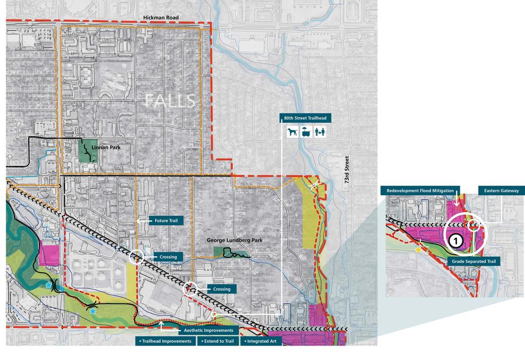
3 58 SECTION OF 2 Zone : Falls The Eastern Gateway provides the first impression of Clive so enhancements are essential. Here we better connect users (especially those to the North) to the trail system and provide options to relax and overlook the Greenbelt. With development so close to the creek here, this node does indeed echo Clive s driving theme distinct by nature. LEGEND Redevelopment Greenbelt - Publicly Owned Greenbelt Acquisition Greenbelt Easement On-Street Bicycle Route Existing Trail Primary Greenbelt Trail - 0' Primary Greenbelt Trail - Relocated Secondary Greenbelt Trail - 8' Soft Trail Trail to be Removed Stream City Limits Existing Bridge New Bridge Existing Bridge to be Replaced * Integrated Art GREENBELT PROGRAM Community Garden Pop-Up Business Dog Park N 600 feet
4
5 60 SECTION 2 OF 2 Zone : Falls Currently trail users breeze past one of Clive s most bustling commerce centers with little notice of the many retail and entertainment venues available. We need improved signage, better access and trail head expansion. It s also opportunity to introduce one of Clive s more significant cultural resources by connecting to Swanson (House) Memorial Park. LEGEND Redevelopment Greenbelt - Publicly Owned Greenbelt Acquisition Greenbelt Easement On-Street Bicycle Route Existing Trail Primary Greenbelt Trail - 0' Primary Greenbelt Trail - Relocated Secondary Greenbelt Trail - 8' Soft Trail Trail to be Removed Stream City Limits Existing Bridge New Bridge Existing Bridge to be Replaced * Integrated Art GREENBELT PROGRAM Bike Rental Pop-Up Business Restrooms Water Fountains Water Access Parking Playground Pavillion N 600 feet
6
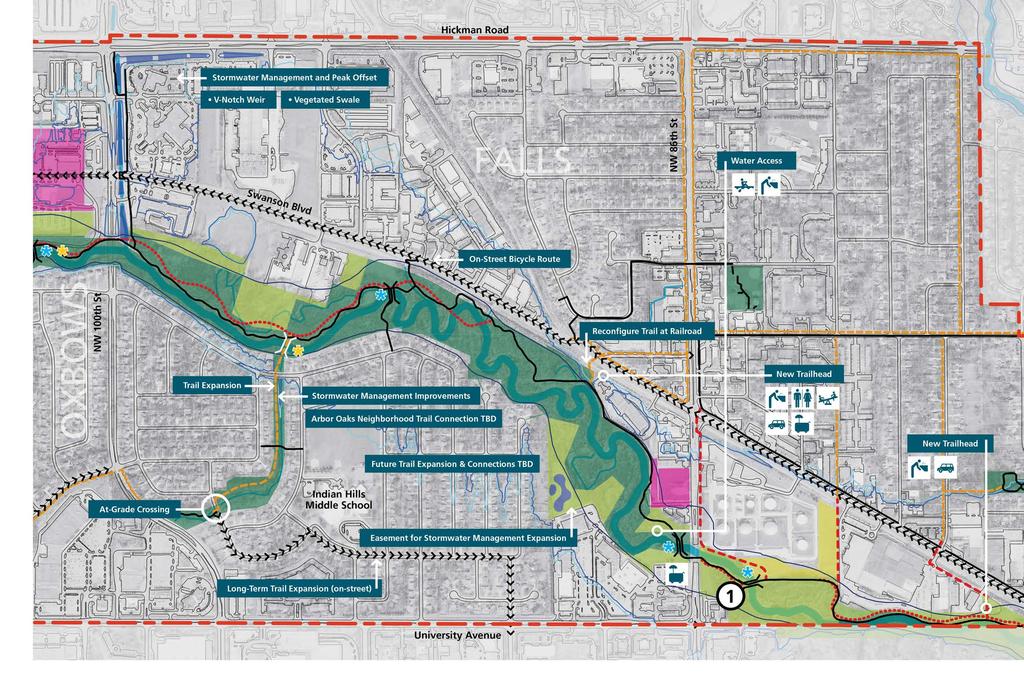
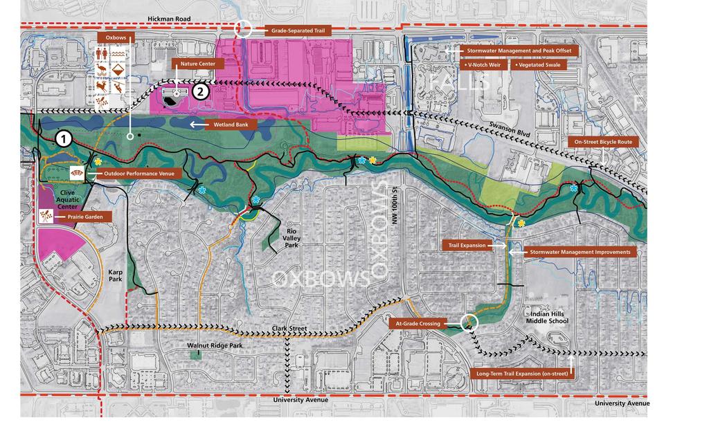
7 62 2 SECTION OF 2 Zone 2: Oxbows 2 Near the Aquatics Center, the plan proposes an outdoor amphitheater, events lawn, gathering spaces, improved accesses and overlooks. The plan also pictures a stronger connection between the Greenbelt and the City Hall/Library complex to the West. In conjunction with the upcoming Water Trails Plan for Central Iowa, this will prove a likely site for launching canoes and kayaks. With Porter Shelter in the floodway (the most floodprone footprint of any stream), the shelter requires high levels of maintenance and its use is limited. A replacement facility, expanded to include indoor/ outdoor options, community features, and storage will move out of the floodway and to the West of this site. (See Clive Education and Adventure Center Node 8). Immediately North of this location, we see an area with potential for multi-use redevelopment and an opportunity to peel away higher-speed cyclists, improving the relaxed atmosphere of the primary Greenbelt trail without forcing extra miles on cycling commuters. A wetland complex (by way of mitigation bank ) is also proposed here and we see exploration and appropriate adventure courses as also having a home in this section of the Greenbelt. The plan also sites the Clive Education and Adventure Center. The facility (estimated 3500 square feet) will serve as education, recreation, and volunteer hub as well as a gathering place for friends and family. LEGEND Redevelopment Greenbelt - Publicly Owned Greenbelt Acquisition Greenbelt Easement On-Street Bicycle Route Existing Trail Primary Greenbelt Trail - 0' Primary Greenbelt Trail - Relocated Secondary Greenbelt Trail - 8' Soft Trail Trail to be Removed Stream City Limits Existing Bridge New Bridge Existing Bridge to be Replaced * Integrated Art GREENBELT PROGRAM Restrooms Wetland Bank Core Wildlife Area Botanical Learning Area Stream Stewardship Demonstration Streambank Restoration Zipline Water Access Ampitheater N 600 feet
8
9 64 2 SECTION 2 OF 2 Zone 2: Oxbows Campbell Park well-supports the community, so needs here are limited but the plan envisions enhanced nature play, warming house, a seasonal skate rink and soft trails throughout potentially supporting a variety of uses including cross-country skiing, mountain biking or hiking. LEGEND Redevelopment Greenbelt - Publicly Owned Greenbelt Acquisition Greenbelt Easement On-Street Bicycle Route Existing Trail Primary Greenbelt Trail - 0' Primary Greenbelt Trail - Relocated Secondary Greenbelt Trail - 8' Soft Trail Trail to be Removed Stream City Limits Existing Bridge New Bridge Existing Bridge to be Replaced * Integrated Art GREENBELT PROGRAM Natural Playscape Disk Golf Ice Skating Rink Volleyball Restrooms Wetland Bank Core Wildlife Area Botanical Learning Area Stream Stewardship Demonstration Streambank Restoration Zipline Ampitheater N 600 feet
10
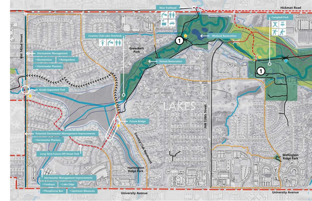
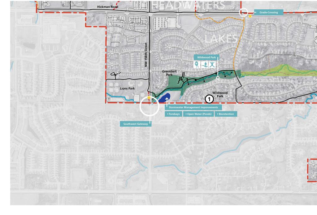
11 66 3 SECTION OF 2 Zone 3: Lakes With excellent visibility and proximity to Hickman Road, an additional trailhead will allow for parking, basic facilities/amenities and provide space for pop-up businesses (e.g., food trucks). Streambanks are in particularly bad shape in this area, so trails will need to be shifted and counter-erosion measures put into play. This also holds potential as an additional significant site for wetland development/ wetland mitigation banking. LEGEND Redevelopment Greenbelt - Publicly Owned Greenbelt Acquisition Greenbelt Easement On-Street Bicycle Route Existing Trail Primary Greenbelt Trail - 0' Primary Greenbelt Trail - Relocated Secondary Greenbelt Trail - 8' Soft Trail Trail to be Removed Stream City Limits Existing Bridge New Bridge Existing Bridge to be Replaced * Integrated Art GREENBELT PROGRAM Shelter Water Fountain Restrooms Pop-Up Business Parking Natural Playscape Disk Golf Ice Skating Rink Volleyball N 600 feet
12
13 68 3 SECTION 2 OF 2 Zone 3: Lakes Wildwood Park is another successful park in this area but its proximity to Eason Elementary begs for improved connections. Children already play in the stream here, but those accesses can be improved for safety and learning. An outdoor classroom (reinvigorating previous efforts) makes sense here along with additional enhanced nature play. Stream stabilization and habitat restoration should occur here and at the same time, provide new learning opportunities for students, parents and residents. LEGEND Redevelopment Greenbelt - Publicly Owned Greenbelt Acquisition Greenbelt Easement On-Street Bicycle Route Existing Trail Primary Greenbelt Trail - 0' Primary Greenbelt Trail - Relocated Secondary Greenbelt Trail - 8' Soft Trail Trail to be Removed Stream City Limits Existing Bridge New Bridge Existing Bridge to be Replaced * Integrated Art GREENBELT PROGRAM Natural Playscape Creek Play Tree Houses N 600 feet
14
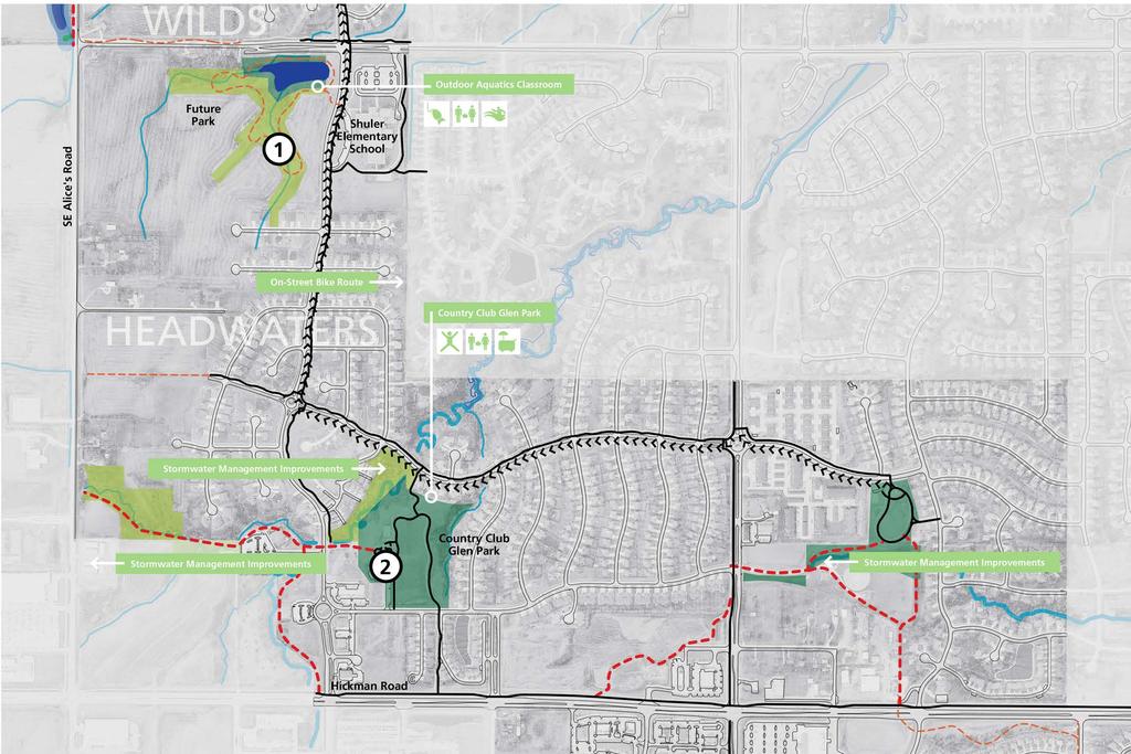
15 70 4 SECTION OF Zone 4: Headwaters 2 Mindful of Schuler Elementary across the street, a future park is proposed here, building from an existing detention basin into a more significant public amenity, prompting learn-to-fish programs, habitat restoration projects and hands-on science instruction. The plan calls for development of a natural playscape, taking advantage of the ravine, at Country Club Glen Park. This area also lends itself to introducing community gardens and pop-up businesses. Strategies for public art are woven throughout the Greenbelt (and not called out particularly in this diagram) but this site also lends itself to the more traditional permanent art installations that have engaged Greenbelt users in the past. LEGEND Redevelopment Greenbelt - Publicly Owned Greenbelt Acquisition Greenbelt Easement On-Street Bicycle Route Existing Trail Primary Greenbelt Trail - 0' Primary Greenbelt Trail - Relocated Secondary Greenbelt Trail - 8' Soft Trail Trail to be Removed Stream City Limits Existing Bridge New Bridge Existing Bridge to be Replaced * Integrated Art GREENBELT PROGRAM Fishing Community Garden Aquatics Natural Playscape Pop-Up Business N 600 feet
16
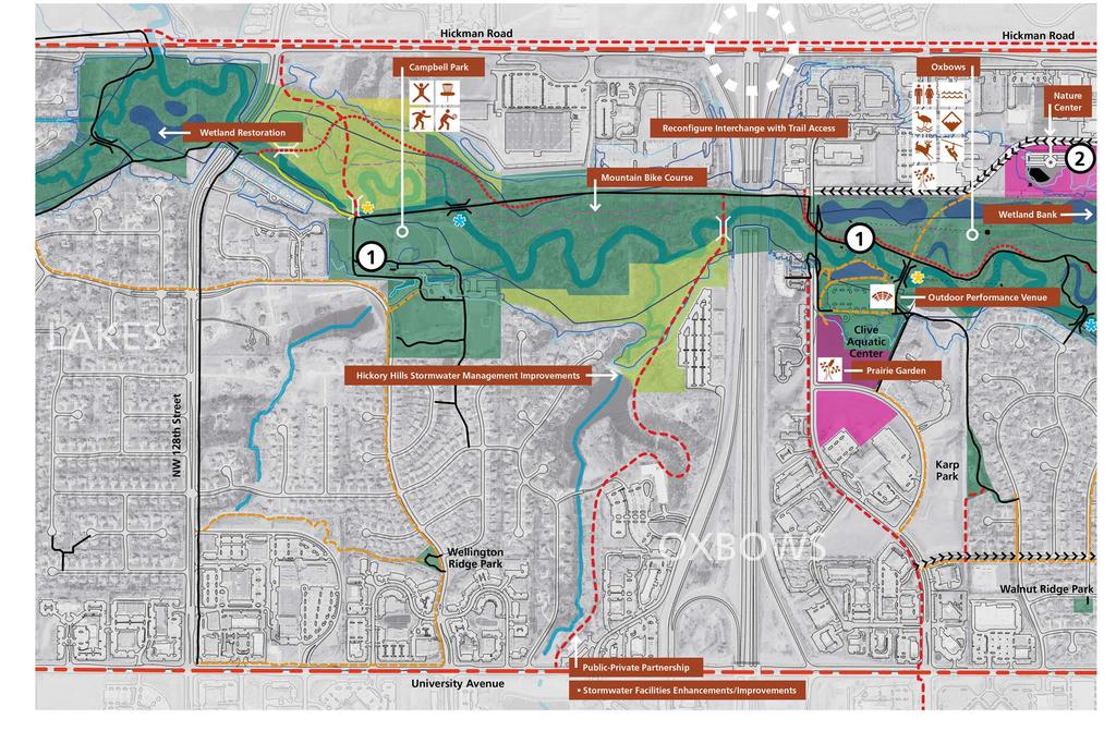
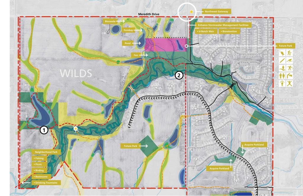
17 72 5 SECTION OF Zone 5: Wilds 2 Here public-private partnerships (city, developers, homeowners) will work to manage water quality and quantity, using the protected green fingers to give everyone easy Greenbelt and open space access. A series of proposed ponds in The Wilds will further opportunities for exceptional scenery, wildlife viewing, and growth in property values while protecting water quality for generations to come. At this Northwest Gateway to Clive, the city owns 60 acres adjacent to the flood plain with plans to secure some additional stream buffer and conservation easements to protect the Greenbelt for the future. Use of natural systems for stormwater management as well as recreation and habitat will be a driver here. The Goal: let this area of Clive serve as an example for Central Iowa (and beyond) of the many benefits in addressing water and natural resources management as the foundation for development not as an expensive after-thought. LEGEND Redevelopment Greenbelt - Publicly Owned Greenbelt Acquisition Greenbelt Easement On-Street Bicycle Route Existing Trail Primary Greenbelt Trail - 0' Primary Greenbelt Trail - Relocated Secondary Greenbelt Trail - 8' Soft Trail Trail to be Removed Stream City Limits Existing Bridge New Bridge Existing Bridge to be Replaced * Integrated Art GREENBELT PROGRAM Fishing Hiking Outdoor Classroom Birding Creek Play Cross-Country Skiing Restrooms Water Fountain Shelter Natural Playscape N 600 feet
18
CHAPTER 5. Chapter 5 Recreation Element
 CHAPTER 5 Recreation Element Chapter 5 Recreation Element The Recreation Element of the Meyers Area Plan is a supplement to the Recreation Element of the TRPA Regional Plan and the El Dorado County General
Frederickson LUAC. Community Plan Update. Parks & Recreation. September 25, 2017
 Frederickson LUAC Community Plan Update Parks & Recreation September 25, 2017 Kimberly Freeman Resource Stewardship Superintendent kimberly.freeman@co.pierce.wa.us 253-798-4261 Joseph Coppo Senior Parks
Chapter eight. Parks and Recreation. Introduction. Crystal Lake Park District
 Chapter eight Parks and Recreation Introduction One of the indicators of quality of life in a city is the parks and recreation system. The City of Crystal Lake is fortunate to have an excellent parks and
NORTHWEST SECTION CONTENTS: CLEVELAND PARK FOLWELL PARK RYAN LAKE PARK VICTORY PRAIRIE DOG PARK VICTORY PARK
 NORTHWEST SECTION CONTENTS: CLEVELAND PARK FOLWELL PARK RYAN LAKE PARK VICTORY PRAIRIE DOG PARK VICTORY PARK LUCY LANEY COMMUNITY SCHOOL N 33RD AVE N 33RD AVE SINGLE-FAMILY RESIDENTIAL MULTI-USE DIAMOND
Lake Myra County Park. Wake County, North Carolina Community Forum #2 June 12, 2008
 Lake Myra County Park Wake County, North Carolina Community Forum #2 June 12, 2008 Welcome and Introduction Meeting Agenda Welcome Introductions of Project Team Master Plan Process Community Forum #1 Updates
A Vision for South Skunk River and Chichaqua Bottoms Greenbelt
 A Vision for South Skunk River and Chichaqua Bottoms Greenbelt Photo: Jim Pease Chichaqua Bottoms Booklet 7 of 8 Greater Des Moines Water Trails and Greenways 1 2016 Table of Contents Booklet 1: Water
2. Goals and Policies. The following are the adopted Parks and Trails Goals for Stillwater Township:
 D. PARKS AND TRAILS 1. Introduction Stillwater Township s population is relatively low, with most residents living on rural residences on large lots. The need for active park space has been minimal in
Tahoe Donner Association Public Scoping Meeting DUDEK
 Tahoe Donner Association Public Scoping Meeting DUDEK Introduction Purpose of this Meeting: Solicit feedback and ideas from members, and staff as we begin the Association Master Plan. Association Master
CITY COUNCIL MARCH 15, 2016 CEDAR LAKE AND LAKE OLATHE PARKS MASTER PLAN. Lake Olathe and Cedar Lake Parks Olathe, Kansas OLATHE PARKS AND RECREATION
 CITY COUNCIL MARCH 15, 2016 MASTER PLAN TEAM STAFF: MICHAEL MEADORS PARKS DIRECTOR MICHAEL LATKA PROJECT MANAGER BRAD CLAY DEPUTY DIRECTOR LISA DONNELLY PARK PROJECT PLANNER PAUL KRUEGER OLATHE PARKS CITY
CRANE LAKE TRAILS NETWORK AND SPACES
 CRANE LAKE TRAILS NETWORK AND SPACES AREA TRAILS COMMUNITY TRAILS GOLD COAST TRAIL LAKE PARK OPTION ONE LAKE PARK OPTION TWO OVERFLOW TRAILHEAD PARKING THE GATE AREA TRAILS Trails are a major resource
The City of Durango Community Interest and Opinion Survey Executive Summary
 The City of Durango Community Interest and Opinion Survey Executive Summary Overview ETC Institute administered a community interest and opinion survey for the City of Durango between January and March
NAVAJO COMMUNITY PLAN
 NAVAJO COMMUNITY PLAN Prepared by the NAVAJO COMMUNITY PLANNERS and THE CITY OF SAN DIEGO City of San Diego Planning Department 202 C Street, MS 4A San Diego, CA 92101 Printed on recycled paper. This information,
Airport Planning Area
 PLANNING AREA POLICIES l AIRPORT Airport Planning Area LOCATION AND CONTEXT The Airport Planning Area ( Airport area ) is a key part of Boise s economy and transportation network; it features a multi-purpose
BRYAN REGIONAL PARK. Presented by: Burditt Consultants November 13, 2018
 BRYAN REGIONAL PARK Presented by: Burditt Consultants November 13, 2018 AGENDA 1. Project Purpose & Mission 2. Project Vision & Goals 3. Stakeholder Feedback 4. Program Overview 5. Phase A Plan Overview
Camping (Primitive) Camping (RV) Electrical Potable Water Grill Established Fire Pit Picnic Table
 Camping (RV) Electrical Potable Water Grill Established Fire Pit Picnic Table") Alden - 9th Road River Mile 777 Map: 38.20833, -98.32031 Managing Agency: Kansas Department of Wildlife, Parks & Tourism Nearest Community: Alden, Rice County Kansas Developed Amenities Provided Parking
Alden - 9th Road River Mile 777 Map: 38.20833, -98.32031 Managing Agency: Kansas Department of Wildlife, Parks & Tourism Nearest Community: Alden, Rice County Kansas Developed Amenities Provided Parking
City of Keller Parks and Facilities Inventory
 City of Keller Parks and Facilities Inventory April 2013 1. BEAR CREEK PARK 44 ACRES 1 Basketball Court with 2 goals 4 Drinking Fountains 1 Large Pavilion with 4 picnic tables, electricity and fireplace
MASTER PLAN EXECUTIVE SUMMARY
 Biscuit Run State Park Scottsville Road (State Route 20) Charlottesville, VA 22902 Biscuit Run State Park MASTER PLAN EXECUTIVE SUMMARY Department of Conservation and Recreation Division of Planning and
City of Haslett. City of East Lansing. City of East Lansing
 Central Park North (Nancy L. Moore Park) Lake Park North Expansion White Park Expansion #2 White Park Expansion #1 County East East Haslett East East TF87-212 Acquisition $90,000.00 Park. TF08-138 Acquisition
SHINGLE CREEK SECTION CONTENTS: BOHANON PARK CREEKVIEW PARK SHINGLE CREEK PARK SHINGLE CREEK REGIONAL TRAIL WEBBER PARK
 SHINGLE CREEK SECTION CONTENTS: BOHANON PARK CREEKVIEW PARK SHINGLE CREEK PARK SHINGLE CREEK REGIONAL TRAIL WEBBER PARK SPLASH PAD Good condition. PARK BUILDING BRYANT AVE N Good condition and unique to
City of Durango 5.8 FUNDING TRAILS DEVELOPMENT
 5.8 FUNDING TRAILS DEVELOPMENT The City has been successful in establishing dedicated local funding sources as well as applying for grants to develop the City s trail system, having received nearly $2.4
Beth Lucas, Senior Planner Stephanie Brewer, Planner Broome County Planning May 12 th, 2016
 Beth Lucas, Senior Planner Stephanie Brewer, Planner Broome County Planning May 12 th, 2016 Background Data Collection Trail Mapping Promotional Strategy December 2014 County s natural beauty identified
Proposal to Redevelop Lower Kananaskis River-Barrier Lake. Bow Valley Provincial Park
 Frequently Asked Questions Proposal to Redevelop Lower Kananaskis River-Barrier Lake Bow Valley Provincial Park Frequently Asked Questions What has been decided? What are the details of the plan? What
CLEVELAND PARK LOCATION AND HISTORY EXISTING CONDITIONS AND CHARACTER LOCATION
 CLEVELAND PARK LOCATION LOCATION AND HISTORY Attempts to create a neighborhood park and playground in the Cleveland neighborhood began in 1926, when the park board designated for acquisition the block
2016 Regional Transportation Alternatives Program (TAP) Grant Application
 Grant Application") 2016 Regional Transportation Alternatives Program (TAP) Grant Application PROJECT TITLE: Yelm-Tenino Trail Extension Feasibility Study TRPC use only GENERAL PROJECT INFORMATION Agency or Organization City
2016 Regional Transportation Alternatives Program (TAP) Grant Application PROJECT TITLE: Yelm-Tenino Trail Extension Feasibility Study TRPC use only GENERAL PROJECT INFORMATION Agency or Organization City
River Parks Trail: Tulsa, Oklahoma
 River Parks Trail: Tulsa, Oklahoma Purpose: The purpose of the River Parks Trail is to maintain, preserve, develop, and promote the Arkansas River for the economic and cultural benefit of the community.
Silver Lake Park An Environmental Jewel for the Citizens of Prince William County
 Silver Lake Park An Environmental Jewel for the Citizens of Prince William County The Prince William Park Authority Mission Statement states: The Prince William County Park Authority will create quality
Flow Stand Up Paddle Board Parkway Plan Analysis
 Regional Parks Department Jeffrey R. Leatherman, Director County of Sacramento Divisions Administration Golf Leisure Services Maintenance Rangers Therapeutic Recreation Services Flow Stand Up Paddle Board
TRUCKEE TAHOE AIRPORT DISTRICT BOARD OF DIRECTOR STAFF REPORT
 AGENDA ITEM: 11 TRUCKEE TAHOE AIRPORT DISTRICT BOARD OF DIRECTOR STAFF REPORT AGENDA TITLE: MEETING DATE: January 24, 2018 PREPARED BY: NTPUD Agency Partnership Opportunity, Multi-Use Trailhead Access
LONG TERM (OPERATION) IMPACTS AND POTENTIAL MITIGATION
 IMPACTS AND POTENTIAL MITIGATION") 3.6 This chapter provides a project-level analysis of potential impacts to recreation sites in the study area including parks, natural areas, open spaces, trails, and playfields, as well as amenities such
3.6 This chapter provides a project-level analysis of potential impacts to recreation sites in the study area including parks, natural areas, open spaces, trails, and playfields, as well as amenities such
10/25/2013. What is the SCORP?! 2013 Local Government Survey 2013 Statewide Public Survey Advisory Group Priority Areas Your Suggestions!
 COLORADO OUTDOOR RECREATION TRENDS RESULTS FROM THE SCORP AND STATEWIDE Colorado Outdoor Recreation Resource Partnership September 2013 PRESENTATION What is the SCORP?! 2013 Local Government Survey 2013
Proposal to Redevelop Lower Kananaskis River-Barrier Lake. Bow Valley Provincial Park. Frequently Asked Questions
 Proposal to Redevelop Lower Kananaskis River-Barrier Lake Bow Valley Provincial Park Frequently Asked Questions What is being proposed? What are the details of the proposal? Where is the project area located?
STORY MILL COMMUNITY PARK
 OWNER: City of Bozeman Department or Parks and Recreation P.O. Box 1230, 415 N. Bozeman Street Bozeman, MT 59715 Tel: (406)-582-2908 APPLICANT: The Trust for Public Land 1007 E. Main Street, Suite 300
Northeast Quadrant Distinctive Features
 NORTHEAST QUADRANT Northeast Quadrant Distinctive Features LAND USE The Northeast Quadrant includes all the area within the planning area that is east of Interstate 5 and to the north of State Route 44.
NORTH HEMPSTEAD BEACH PARK MASTER PLAN
 NORTH HEMPSTEAD BEACH PARK MASTER PLAN COMMUNITY DESIGN CHARRETTE Supervisor Judi Bosworth Viviana L. Russell Peter J. Zuckerman Angelo P. Ferrara Anna M. Kaplan Lee R. Seeman Dina M. De Giorgio VISIONING
Villages at Buffalo Run East
 Villages at Buffalo Run East Neighborhood Park Subhead to title page goes here. Public Design Meeting April 9, 2015 Capital Improvement Program Commerce City s $137 million CIP is the result of a 2013
SOUTH INTERCHANGE AREA
 Santaquin City General Plan 1 Location and Characteristics The South Interchange Area of Santaquin is located west of Interstate 15 and south of 500 South (Figure 1). It includes properties already annexed
The Narrows Waterfront Park A Crown Jewel for Southern Brooklyn
 The Narrows Waterfront Park A Crown Jewel for Southern Brooklyn In New York, the unquestioned popularity of urban spaces such as Riverside Park, the High Line, Brooklyn Bridge Park and others has demonstrated
BACK COUNTRY UNIT PREFERRED ALTERNATIVE
 BACK COUNTRY UNIT PREFERRED ALTERNATIVE San Francisco (118 mi) Carmel-By-The-Sea Carmel River Carmel Valley Road State Beach Private Property Point Lobos State Reserve Point Lobos Ranch RUSTIC CAMPING
Salmon Centre of Excellence
 Salmon Centre of Excellence Concept Proposal Refresh & Inspire 3.5 Acre Waterfront Task Force July 25 th, 2017 Dr. Jim Powell BC Centre for Aquatic Health Sciences Society Who are BC CAHS? Non-profit society
Welcome to the future of Terwillegar Park a Unique Natural Park
 Welcome to the future of Terwillegar Park a Unique Natural Park 1 Introduction The Terwillegar Park Concept Plan study will develop an overall concept plan, management objectives and development guidelines
WEST CENTRAL SECTION CONTENTS: FARWELL PARK NORTH COMMONS PARK OLIVER TRIANGLE RUSSELL PARK THEODORE WIRTH REGIONAL PARK VALLEY VIEW PARK WILLARD PARK
 WEST CENTRAL SECTION CONTENTS: FARWELL PARK NORTH COMMONS PARK OLIVER TRIANGLE RUSSELL PARK THEODORE WIRTH REGIONAL PARK VALLEY VIEW PARK WILLARD PARK FARWELL PLACE THOMAS AVE N SWING BENCH PICNIC AREA
ZoPath Trail. Extreme Park. Group III. Brendan Pillar, Conor Coakley James Amendola, & Mark McDermott. May 4, 2006
 ZoPath Trail & Extreme Park Group III Brendan Pillar, Conor Coakley James Amendola, & Mark McDermott May 4, 2006 HOW TO GET FROM THE TOWPATH S NORTHERN TRAILHEAD TO HERE? Bridging Two 1 st -Class Regional
PALO CORONA REGIONAL PARK MPRPD BOARD MEETING AUGUST 8, 2018
 PALO CORONA REGIONAL PARK MPRPD BOARD MEETING AUGUST 8, 2018 ACKNOWLEDGEMENTS AGENCIES AND ORGANIZATIONS The Trust for Public Land Big Sur Land Trust Santa Lucia Conservancy California State Parks Point
J. Recreation Plan of Conservation and Development. The Town of Hebron. Section 2. Preservation of Unique Assets. 1 P a g e
 The Town of Hebron Section 2 2014 Plan of Conservation and Development Preservation of Unique Assets J. Recreation Open spaces, parks, sports fields, and recreational programs are considered essential
Village of Taos Ski Valley 2015 Master Plan. Recreation Element
 Village of Taos Ski Valley 2015 Master Plan Taos Ski Valley is known across the world for skiing and winter sports, but the Village has more to offer than advanced skiing terrain and short lift lines.
National Recreation Trail Application for Designation
 National Recreation Trail Application for Designation Introduction Thank you for your interest in the National Recreation Trail (NRT) program. Completed NRT application packages must be submitted by December
M E S T I Z O C U R T I S P A R K
 ARAPAHOE CONNECTION TO BUS ROUTE AT ND AND LAWRENCE, FUTURE LIGHT RAIL STATION LEGEND SOCIAL TRAIL FLAGSTONE PAVING TO RESTORE/MAINTAIN CONCRETE PAVING DIAGONAL CURVILINEAR SOCIAL ROUTE IS OUT OF HISTORIC
MORGAN CREEK GREENWAY Final Report APPENDICES
 APPENDICES MORGAN CREEK GREENWAY Appendix A Photos of Existing Conditions in Trail Corridor Photos of existing conditions Main trail corridor - February 2009 Photos of existing conditions south bank Morgan
Classifications, Inventory and Level of Service
 Classifications, Inventory and Level of Service Section 3 Kenmore Park, Recreation and Open Space Plan 1 P a g e Classifications and Inventory Park Classifications Kenmore classifies its parks based upon
A CASE FOR COMPLETING THE JORDAN RIVER PARKWAY: A
 A CASE FOR COMPLETING THE JORDAN RIVER PARKWAY: A safe crossing at 9000 South and 850 West Proposed 9000 South Underpass Parkway Timeline Parkway, Trail, and Tourism Facts Blueprint Jordan River 1971 1973
Inner Harbor 2.0. The resulting Inner Harbor 2.0 Plan provides a road map for a more sustainable, attractive and active Inner Harbor.
 Inner Harbor 2.0 In 2012, recognizing that some of the Inner Harbor infrastructure had outlived its useful life, the City completed a State of Good Repair Study, while Waterfront Partnership, along with
Chapter 6. Trail Design. Trail Design
 Chapter 6 Trail Design Trail Design The trail winds through a region rich in scenic beauty, cultural, and natural history. Volunteer landscape architects working with the Core and Planning Teams, have
REFRESH & INSPIRED REVISITED
 The Waterfront Task Force is seeking inspiration for concepts that bring social, environmental, and economic benefits to our REFRESH & INSPIRED REVISITED Community ideas were pitched during the Refresh
Segment 2: La Crescent to Miller s Corner
 goal of the USFWS refuges is to conserve, protect and enhance fish, wildlife and plants and their habitats for the continuing benefit of the American people. Refuge lands are used largely for fishing,
Webber Park Master Plan Charrette Summary
 SMALL GROUP #1 - September 29, 2011 Webber Park Master Plan Charrette Summary More trash cans, especially near picnic grounds A year round pool is very needed-physical & mental health are significantly
Preferred Recreation Recommendations Stemilt-Squilchuck Recreation Plan March 2018
 Preferred Recreation Recommendations Stemilt-Squilchuck Recreation Plan March 2018 Below are the recommended recreation ideas and strategies that package together the various recreation concepts compiled
Everett Riverwalk Life style explore
 Life style explore Project Overview The 217-acre Everett Riverfront redevelopment is visible from I-5 with traffic counts charted at 170,000+ vehicles per day with direct freeway access from 4-way interchange.
SAN ANTONIO RIVER IMPROVEMENTS PROJECT. August 6, 2008
 SAN ANTONIO RIVER IMPROVEMENTS PROJECT August 6, 2008 1 History of the SA River Improvements 1921 Flood Olmos Dam Complete in 1929 Downtown Flood Relief Projects in 1950 s Dams on the River Channel and
BASSETTS CREEK SECTION CONTENTS: BASSETTS CREEK BRYN MAWR LUCE LINE
 BASSETTS CREEK SECTION CONTENTS: BASSETTS CREEK BRYN MAWR LUCE LINE GLENWOOD AVE MULTI-USE DIAMONDS VINCENT AVE N MORGAN AVE N PENN AVE N DOG PARK MULTI-USE FIELDS PLAYGROUND AK E RD S CHESTNUT AVE DA
Stony Creek Master Plan Public Meeting #2. May 21, 2016
 Stony Creek Master Plan Public Meeting #2 May 21, 2016 Today s Agenda 10:00 10:20 am Presentation 10:20 10:45 am Q & A 10:45 11:30 am Browse, discuss, and comment Metroparks Master Plan Process 4 months
Appendix B - Undeveloped Parks and Existing Parks with Remaining Development Programming
 Appendix B - Undeveloped Parks and Existing Parks with Remaining Development Programming Table of Contents Appendix B - Undeveloped Parks and Existing Parks with Remaining Development Programming Table
GREATER DES MOINES WATER TRAILS AND GREENWAYS PLAN
 GREATER DES MOINES WATER TRAILS AND GREENWAYS PLAN A shared vision for our rivers, creeks and greenways. www.dmampo.org/water-trails Des Moines Area MPO Iowa Department of Natural Resources dmampo.org/water-trails
National Recreation Trail Update Form
 National Recreation Trail Update Form Introduction Thank you for taking the time to complete this form. Your assistance will help ensure that the National Recreation Trail (NRT) database is complete and
WATER PETALUMA TRAIL WATER WAYS PROJECT PORTFOLIO. petalumawaterways.org OVERVIEW
 WATER TRAIL PROJECT PORTFOLIO OVERVIEW Thirteen miles upstream of San Pablo Bay, Petaluma is the northern point on the San Francisco Bay Water Trail, a network of access points throughout the region. Most
SAN ANTONIO RIVER IMPROVEMENTS PROJECT. April 27, 2009
 SAN ANTONIO RIVER IMPROVEMENTS PROJECT April 27, 2009 1 Project Limits 2 Project Partners City of San Antonio Provides project funding for project amenities (i.e.. Sidewalks, Landscaping, Lighting, etc.)
Acquisition in fee simple of approximately one-half acre of property on the shore of Spring Lake to expand the Lakeside Beach Park.
 Lakeside Beach TF00-136 $122,550.00 in fee simple of approximately one-half acre of property on the shore of Spring Lake to exp the Lakeside Beach. 2000 River Ravines TF00-150 $910,000.00 in fee simple
Citrus Heights Creek Corridor Trail Project Trail Advisory Group Field Trip #2 September 11, :00 11:00 am Trellis Hall, Citrus Heights
 September 11, 2013 9:00 11:00 am Trellis Hall, Citrus Heights Project Overview The City of Citrus Heights is studying the feasibility of establishing a multi use trail system within the City s 26 miles
Green Legacy. Securing our. Greenlands Strategy
 Greenlands Strategy Securing our Green Legacy Together we can create an interconnected network of Greenlands for the health and well-being of the environment and future generations Caring for the Credit
Interpreting the Lagan Valley Regional Park. The Lagan Navigation: The unfolding story of a proud heritage Dr Andy Bridge
 Interpreting the Lagan Valley Regional Park The Lagan Navigation: The unfolding story of a proud heritage Dr Andy Bridge A bit about us Designated an AONB under the Amenity Lands Act (NI) 1965 The Regional
MAPLEWOOD VILLAGE CENTRE AND INNOVATION DISTRICT IMPLEMENTATION PLAN & DESIGN GUIDELINES. November 6, 2017 Regular Meeting of Council
 MAPLEWOOD VILLAGE CENTRE AND INNOVATION DISTRICT IMPLEMENTATION PLAN & DESIGN GUIDELINES November 6, 2017 Regular Meeting of Council Recommendation THAT Council: Approve the Maplewood Village Centre and
$866,000. $1,400,000 Health Benefits $13,156,000 TOTAL ANNUAL DIRECT BENEFITS. $10,890,000 Economic Benefits
 SINGING RIVER TRAIL Trails Create Value + Generate Economic Activity Trails generate economic returns through improved health, safety, and environmental conditions, raise property values, and attract visitors.
ADVENTURE PLAN EXPLORE PARK
 ADVENTURE PLAN ROANOKE COUNTY S EXPLORE PARK ROANOKE COUNTY PARKS, RECREATION AND TOURISM 1206 KESSLER MILL RD SALEM, VA 24153 (540) 387-6078 WHAT S INCLUDED? Explore Park Adventure Plan - Guided by extensive
Rogue River Access and Management Plan Draft Alternatives
 Rogue River Access and Management Plan Draft Alternatives The Rogue River Access and Management Plan was initiated in December, 2011 and is being led by Jackson County Parks (JCP) and Oregon Department
DESCRIPTION OF DRAFT LAND USE PLAN ALTERNATIVES. Overview of Draft Alternatives (Common Features and Themes)
") Concord Hills Regional Park Land Use Plan EAST BAY REGIONAL PARK DISTRICT DESCRIPTION OF DRAFT LAND USE PLAN ALTERNATIVES The following memorandum describes the draft Alternatives for Concord Hills Regional
Concord Hills Regional Park Land Use Plan EAST BAY REGIONAL PARK DISTRICT DESCRIPTION OF DRAFT LAND USE PLAN ALTERNATIVES The following memorandum describes the draft Alternatives for Concord Hills Regional
NORTH OF BROADWAY SECTION CONTENTS: COTTAGE PARK FARVIEW PARK GLEN GALE PARK IRVING TRIANGLE JORDAN PARK NEWTON PARK PERKINS HILL PARK
 NORTH OF BROADWAY SECTION CONTENTS: COTTAGE PARK FARVIEW PARK GLEN GALE PARK IRVING TRIANGLE JORDAN PARK NEWTON PARK PERKINS HILL PARK N ILIO NA VE N JAM ES AV E PLAYGROUND PAR K PRO PER TY B OUN DAR Y
Park Design and Location Criteria
 Park Design and Location Criteria This section is presented in the interest of assisting park and recreation agencies in the development of a system of parks and recreation areas. A recreation system is
LANDING S PARK CONCEPTUAL PLAN HAMILTON ANDERSON JANUARY City of Novi, Michigan. The Park at 13 Mile and Old Novi Road
 HAMILTON ANDERSON JANUARY 2012 LANDING S PARK CONCEPTUAL PLAN January 2012 Page 1 of 15 January 2012 PROJECT GOALS Activate the park by introducing new elements Provide clear access to the water and enhance
MOREAU LAKE STATE PARK CURRENT PLANNING EFFORTS
 MOREAU LAKE STATE PARK CURRENT PLANNING EFFORTS PLANNING EFFORTS S O U T H E R N PA L M E R T O W N CONSERVATION & ECONOMIC DEVELOPMENT STRATEGY Moreau Lake State Park Master Plan Mt. McGregor Correctional
Waterfront Concept Plan: Community Survey Summary
 Waterfront Concept Plan: Community Survey Summary Published April 20, 2016 #1100085 Introduction The survey was one component of the public consultation process endorsed by Council in October, 2015. This
CHAPTER 3 PLANNING GOALS
 CHAPTER 3 PLANNING GOALS AND PUBLIC INPUT INTRODUCTION This portion of the Algonac Master Plan is intended to outline a course for action in achieving the community s vision for the future. Throughout
13.1 REGIONAL TOURISM ISSUES AND SUMMARY OF FINDINGS
 13 REGIONAL TOURISM T he County of Mariposa s recreation needs and facilities fall within two categories: regional tourism and local recreation. This Element focuses on regional tourism issues related
2018 JULY CELEBRATION
 2018 JULY CELEBRATION Sunday Monday Tuesday Wednesday Thursday Friday Saturday 1 2 3 4 5 6 7 Photo Contest July 1-31 Enter and you could win a prize package from Bismarck Parks and Recreation. 8 BPRD Geocache
Rating: 5.0 (scale of 1-10)
") 95 Community Trail System Groundcover: 2-metre paved path, 1- metre grass buffer on either side. Location: Fort St. John Ownership: City of Fort St. John Rating: 5.0 (scale of 1-10) Strategic value: Linear
95 Community Trail System Groundcover: 2-metre paved path, 1- metre grass buffer on either side. Location: Fort St. John Ownership: City of Fort St. John Rating: 5.0 (scale of 1-10) Strategic value: Linear
Trail Etiquette. Hours of Operation. Trail Accessibility
 Trail Guide The Elmhurst Park District, with 28 parks and over 460 acres of land, offers nearly six miles of paved or asphalt park trails and maintains an additional 3.6 miles of trails within Elmhurst.
CHAPTER 9. PARKS, RECREATION, TRAILS AND NATURAL AREA RESOURCES
 CHAPTER 9. PARKS, RECREATION, TRAILS AND NATURAL AREA RESOURCES The forms of recreation chosen by residents and visitors in the CBJ are as diverse as the population. Many people choose to recreate in developed
MAIN LAKE PROVINCIAL PARK
 MAIN LAKE PROVINCIAL PARK PURPOSE STATEMENT AND ZONING PLAN March 2003 MAIN LAKE PROVINCIAL PARK Purpose Statement and Zoning Plan Primary Role The primary role of Main Lake Park is to protect a biologically
Waukee Trailhead Public Art and Amenities Project
 Waukee - Trailhead Public Art and Amenities Project Sponsor Waukee Project Title Waukee Trailhead Public Art and Amenities Project Termini Description ( i.e. Park Avenue to 19th Street) NE Intersection
Hemisfair Civic Park. Vision and Program Plan
 Hemisfair Civic Park Vision and Program Plan OCTOBER 2013 Hemisfair Civic Park Vision and Program Plan Prepared under the direction of the Hemisfair Park Area Redevelopment Corporation. Planning assistance
FOLWELL PARK LOCATION AND HISTORY LOCATION
 FOLWELL PARK LOCATION LOCATION AND HISTORY Folwell Park is a large (by neighborhood park standards) tract of land located south of Dowling Avenue between Humboldt and Knox Avenues. The land for the park
OAK RIDGES MORAINE FOUNDATION
 June 2009 OAK RIDGES MORAINE FOUNDATION The Oak Ridges Moraine Foundation was created in 2002 to help preserve, protect and restore the environmental integrity of the Oak Ridges Moraine, a prominent geological
Blue River Trail Master Plan JSA to Town Hall June 2004
 Blue River Trail Master Plan JSA to Town Hall June 2004 Prepared for: Silverthorne Town Council Silverthorne SPORT Committee Department of Recreation and Culture Silverthorne Public Works Silverthorne
Chapter 2: Summary of Existing Open Space System
 Chapter 2: Summary of Existing Open Space System In 1976, the Wake County Board of Commissioners established the Wake County Parks and Recreation Department in order to provide park facilities and programs
THE SENSIBLE ROCKY MOUNTAIN INVESTMENT CHOICE.
 THE SENSIBLE ROCKY MOUNTAIN INVESTMENT CHOICE 1 2 THE SENSIBLE ROCKY MOUNTAIN INVESTMENT CHOICE BIG MOUNTAINS. BIG BUSINESS. BIG OPPORTUNITY. Sparwood, BC is yours and mine. We may be known as that town
Municipal Park Descriptions: 1. Bear Hollow Park 4100 Bear Hollow Park Court, Murrysville, PA acres
 MUNICIPAL PARK DESCRIPTIONS Murrysville has a wide variety of parks and recreational facilities including sports fields, neighborhood parks, community parks, a Community Center, and extensive natural areas
4MRV Parks Master Plan: Site Analysis
 4MRV Parks Master Plan: Site Analysis Lardner/Klein Landscape Architects in association with: RK&K Grimm + Parker Kittelson & Associates Partners for Economic Solutions RIB U.S.Cost Civil Engineering Architecture
10641 Scripps Summit Court San Diego, CA 92131
 10641 Scripps Summit Court San Diego, CA 92131 EXPERIENCE SUMMIT POINTE Central location with Visibility & access A distinctive opportunity Summit Pointe is a unique tenant focused offi ce renovation in
Plaza del Rio. Rio Grande Sanctuary. Exclusive Home Sites in the San Luis Valley, Colorado
 Plaza del Rio Rio Grande Sanctuary Photography by Gary Tyson River Valley Group, LLC and Team Murphy Realty, LLC offer for sale: Exclusive Home Sites in the San Luis Valley, Colorado Plaza del Rio Exclusive
Lake Waconia Regional Park 6. Lake Waconia Regional Park
 Lower Lakeshore Trail Interpretive/Adventure Trail Multiple Seating & Observation Areas Flexible Day Use Recreation Area Docks/Fishing Group Camping Group Day Use Space Winter Gathering/Event Space -Season
Methow Trails. Master Plan. Oct
 Methow Trails Master Plan Oct 15 2018 Methow Trails is a 501(c) (3) organization 1.0 INTRODUCTION 2.0 BACKGROUND 2.1 History 2.1.1 Nordic Skiing in the Methow Valley 2.1.2 Connected trail system 2.1.3
FY20 BUDGET PRESENTATION
 FY20 BUDGET PRESENTATION Mission Statement: To provide for diverse recreational opportunities and amenities that enhance the quality of life for our residents and visitors to the City of Frederick through