Foel Ortho Farmhouse, Bunkhouse, Treehouse, Spa & Follies + Info & Local Maps to land marks & pubs etc.
|
|
|
- Edward Nicholson
- 5 years ago
- Views:
Transcription

1 Directions to: Foel Ortho Farmhouse, Bunkhouse, Treehouse, Spa & Follies + Info & Local Maps to land marks & pubs etc. For accurate location of private track use: disco.organic.digestion There are 4 houses with our postcode - the other three are further away from Penybontfawr. Look out for our black & white Foelortho sign on the road side. Penybontfawr / Hirnant Near Oswestry, SY10 0HU, Careful with Sat Nav! SY, then the number one hundred, then HU 2 Hours 40 Mins from Oxford - keeping to speed limits Contact Ed & Jenny Matthews on edjenny.miller@btinternet.com Tel:
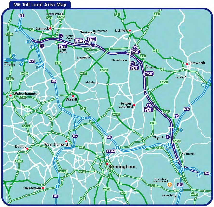
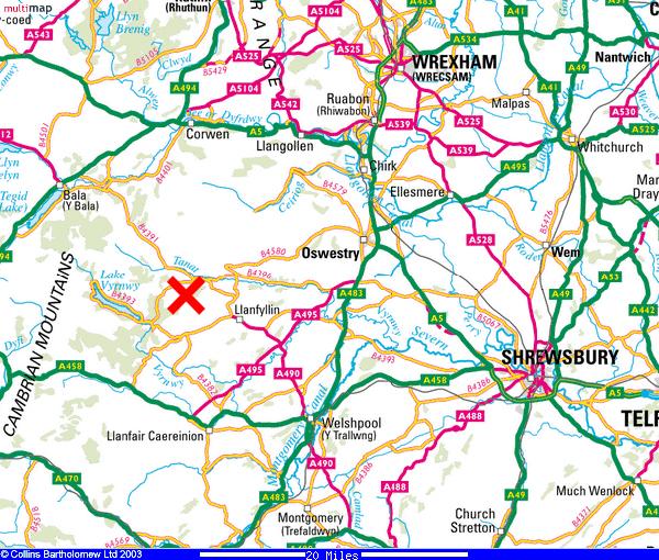
2 or Fast Motorways like the M54 make it quick to get here. 3.5 Hours from London, 2.5 from Oxford and 1.5 from Birmingham! Foel Ortho (pronounced 'Voil Orr-Thow') Farmhouse & Bunkhouses Penybontfawr, Near Oswestry, SY10 0HU, Satellite Navigation entry is: SY, then one hundred, then HU!! (There are 4 farms that share the same postcode - SY10 0HU, the other 3 are further away from Penybontfawr. Look out for the black and white road sign saying Foel Ortho and follow this down the farm track to Foel Ortho Farmhouse & Bunkhouses). For an accurate location of the top of the track use disco.organic.digestion or Make sure you arrive with plenty of petrol in your tank. There are not many petrol stations immediately nearby. Directions from Oxford ( 2 Hours 30 Mins - keeping to speed limits...):- 1. BEST route! a) A34 (N), b) M40 (N), c) M42 (N), d) M6 Toll (exit Junction T8), e) M54 towards Telford. Stay on M54, it becomes the A5. (On way back, exit M54 at Junction 1 and take first left at island signed Cannock to get to Toll). Good service station on Toll is Norton Canes, between Junction T6 and T Telford Motorway Service Station off Junction 4 on M54 is not bad Burger King etc. Or: (N), M40 (N), M42 (N), M6 (N), M54 (W). M6 can be a nightmare 2. Keep going on A5 towards Oswestry (this will by-pass Shrewsbury) (remaining dist.to Farmhouse / Bunkhouses approx.30 miles). 3. After signs to Nesscliff turn Left onto B4396 signed Knockin. 4. Go through Knockin. 5. Just after Llynclys (pronounced Hlunclus) at White Lion Pub cross roads, go straight over (crossing the A483). Zero your milometer! You will pass through / see the following places / things - distance from the White Lion Pub is indicated. Porth-y-waen (0.8 miles) & the The Lime Kiln At 2 Miles DO NOT TURN LEFT towards Vyrnwy onto A495 but remain on B4396. Llanyblodwel (2.4 miles)
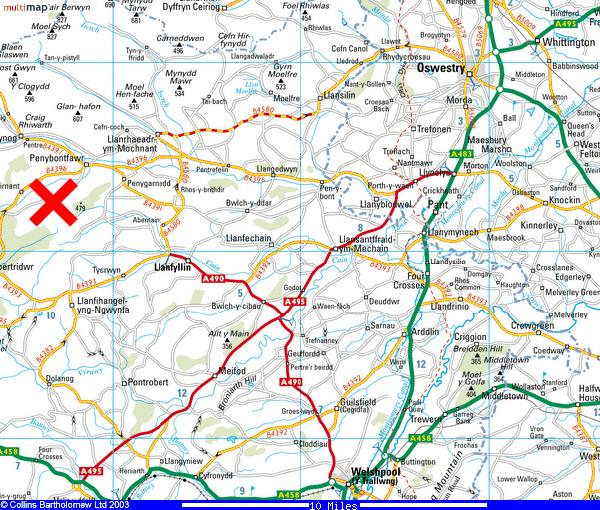
 Llangedwyn village (6.2 miles) Pentre Felin village (8.3 miles) 6. At the Plough & Wynnstay Arms signs, TURN LEFT sign posted Bala & Penybontfawr' (9.")
, TURN RIGHT sign posted Penybontfawr, go 1 mile downhill. Arrive at Penybontfawr (13.1 miles) Zero your milometer again!! 7.")
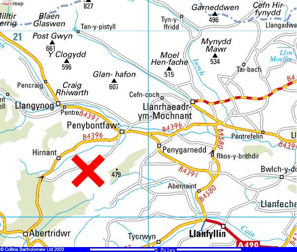
3 Powys sign (Welsh border) & "Tanat Valley Welcome" Sign & village of Penybont Llannerch Emrys (4.7 miles) Penybont Inn Pub in Penybont Llannerch Emrys (4.8 miles) NOT to be confused with Penybontfawr! The Green Inn Pub (5.8 miles) Llangedwyn village (6.2 miles) Pentre Felin village (8.3 miles) 6. At the Plough & Wynnstay Arms signs, TURN LEFT sign posted Bala & Penybontfawr' (9.6 miles) - don t go straight on to Llanrhaeadr (the road you turn onto is still the B4396). At T junction at the top of a small climb (12.1 miles), TURN RIGHT sign posted Penybontfawr, go 1 mile downhill. Arrive at Penybontfawr (13.1 miles) Zero your milometer again!! 7. In Penybontfawr, after passing the Railway Inn Pub on the right, TURN FIRST LEFT, immediately after going over a very small bridge. Sign posted Lake Vyrnwy 6 miles. See local map of village. 8. Go 0.4 of a mile up lane, TURN LEFT downhill, immediately after Pentre farm which is on the left opposite some white wrought iron gates and railings (there is a white triangle painted on the road you want). Follow this lane down, over a bridge, up past a Chapel on your right and a Farm on the Right half way up very steep hill. 9. At the top of the very steep hill where the road starts to flatten out, go straight over the crossroads. 50 yards later, take the upper (right hand) fork of the two tarmac roads, this road rises gently up the right hand side of the valley for one mile. 10. Notice a green dustbin on your left marked Foel Ortho, 60 yards beyond this bin, there is a black and white road sign that says Foel Ortho, follow this down the rough farm track to your Left. Caution! There are 4 farms that share the same postcode - SY10 0HU, the other 3 farms are further away from Penybontfawr. Sign is at exactly: Caution! Drive slowly & carefully! Especially if your car is low and has little ground clearance. 11. Follow track for 300 yards (past new barn on Right) to Farmhouse, Bunkhouse & Treehouse. Bunkhouse guests: Please ark at 45 degrees along the fence on your left - please don t block the end gate. Farmhouse guests: please drive through the gate and park at the front of the Farmhouse. Treehouse guests: Please park in the bay next to the Treehouse on the right just before you descend the last bit of track. (In the pebbled area, the main Bunkhouse entrance is on the right, the Stable Flat is on the left and the Farmhouse entrance is via an arched doorway in wall don t fall in the moat!). All the necessary maps are shown below so please scroll down for more detail.

4
5
6
7

. IMPORTANT!")
.")
8 You will be driving up from Penybontfawr in this direction. Drive past a barn Turn left onto the farm track here, at the Foel Ortho road sign on your left. Track is rough and downhill. Drive carefully!! Especially if your car is low and has little ground clearance. Foel Ortho Farmhouse & Bunkhouses View down the track Parking Instructions Picture showing Foel Ortho Farmhouse, Bunkhouse & Treehouse Track (looking in the direction you are driving). IMPORTANT! View looking back up the track from Foel Ortho Farmhouse Guests: Please go through the gate after the log store and park at the front of the Farmhouse. Bunkhouse guests: After unloading please park along the fence at 45 degrees (not next to buildings). Please leave access at all times for Farmhouse vehicles that will be going through the gate and parking at the front thanks! Treehouse Guests: please park in the bay at the top of the track before you reach the Farmhouse and Bunkhouse.

9 Some Important Notes For videos of all the walks / mountain bike routes / activities in the area go to or and scroll down to the link to our YouTube Channel. For an even more extensive list of activities, please download Foel Ortho Top Activity Suggestions from our website - Mobile phones work on the tops of hills, there is some signal at the top of the track depending on carrier. The Tavern Bar at Lake Vyrnwy Hotel, Lake Vyrnwy Hotel, Llanwddyn, Powys, SY10 0LY, Tel , Fax , info@lakevyrnwyhotel.co.uk Grid Reference SJ Penybontfawr Railway Inn. Tel: (Terry). Great food! The restaurant and tearoom, Tan-y-Pistyll, Waterfall Lane, Llanrhaeadr ym Mochnant, Powys SY10 0BZ, Wales, Grid Reference SJ There is a Spa shop in the middle of Llanrhaeadr. Cash point at Llanrhaeadr. Number of Payphone in the Farmhouse is: All health and safety information on where the nearest Dentist / Doctors / Fire brigade / A & E is available on disk or hardcopy please ask. After trip, recycling is located on the left hand side in a car park opposite the garage as you leave the local village Penybontfawr to go home.
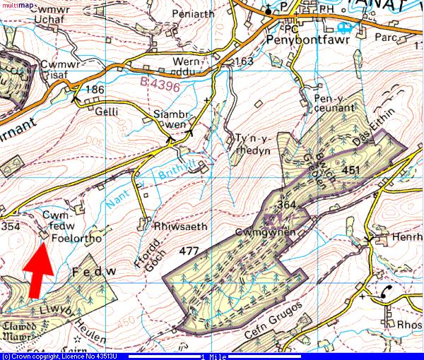
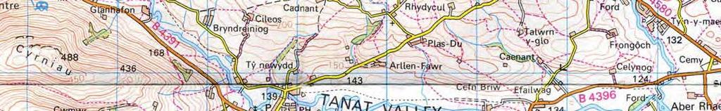
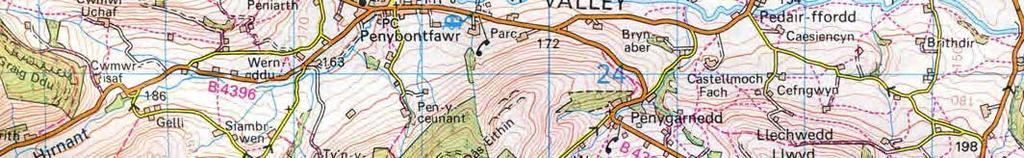
10 Map from local village Penybontfawr (top right) to Foel Ortho Farmhouse (bottom left). (mobile phones may not have reception in many areas once in the mountains).
 Penybontfawr Cader Berwyn (Cadair Berwyn) Pistyll Rhaeadr (Waterfall) Aran Fawddwy")
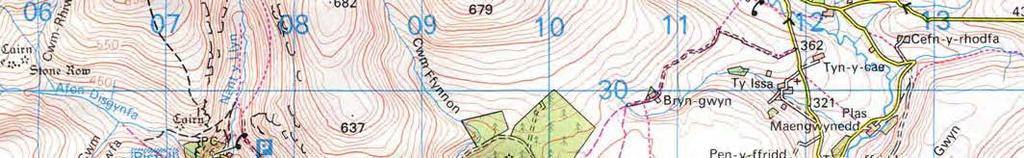
11 Map showing: Foel Ortho Farm & Bunkhouses (See large red arrow) Lake Vyrnwy Lake Bala (Llyn Tegid) Penybontfawr Cader Berwyn (Cadair Berwyn) Pistyll Rhaeadr (Waterfall) Aran Fawddwy Llanfyllin
 to Foel Ortho Farmhouse (top")

12 Map from Lake Vyrnwy Hotel ( ) to Foel Ortho Farmhouse (top right). (mobile phones may not have reception in many areas once in the mountains).


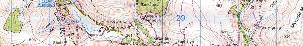
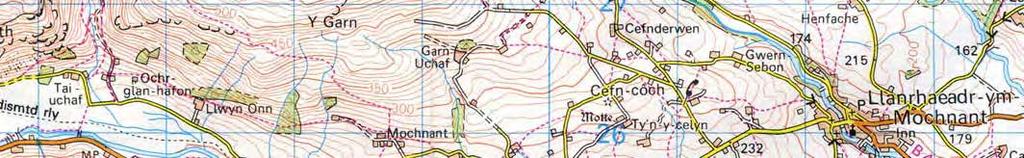

13 Map showing local village Penybontfawr, Foel Ortho Farmhouse, Pistyll Rhaeadr Waterfall and Cadair Berwyn Triangulation Point. (mobile may not have reception in many areas).
Local Attractions & Contact Details
 Local Attractions & Contact Details Near to Foel Ortho Farm & Bunkhouse Distance - around 2 miles Duration - around an hour Distance - around 2 miles Walk / Mountain Bike / Horse Riding routes have not
Upper Valley Barns Cwmwr Uchaf. Barns Information
 Upper Valley Barns Cwmwr Uchaf Barns Information Upper Valley Barns - Cwmwr Uchaf Pen y bont fawr Oswestry Wales SY10 0HP Tel: 07824 876697 Contents: Welcome to Upper Valley Barns - Cwmwr Uchaf General
The Mendip Way. Route Directions and Maps Uphill to Wells
 The Mendip Way Route Directions and Maps Uphill to Wells Website: www.mendiphillsaonb.org.uk Email: mendip@mendiphillsaonb.org.uk Facebook & Twitter: @MendipHillsAONB Phone: 01761462338 1 Uphill to Loxton
Leisure Parks Information
 Leisure Parks Information Events & Open Days Maguire s Park Homes will be attending these events Southern Motorcaravan Show 18th 20th May Newbury Showground, Priors Court, Thatcham, Berkshire, RG18 9QZ
Slad over to Pitchcombe and back
 The walk climbs up from Slad over Wickridge Hill, descends to near Pitchcombe, then climbs back over Wickridge hill and round the back of Slad. Page 1 Start Point: SO 8718 0732 The Woolpack, Slad Length:
Pontfadog. Walk A. Walk A
 Walk A A Bird s eye view of the village 2km. (1 1 /2 miles); height gain 45m. (150ft) about 45 minutes. Six minutes walk along the main road towards Glyn Ceiriog reach a signpost to Llwynmawr. Take the
Joining instructions. Women s Conference th - 30 th March St Johns Hotel, Solihull
 Joining instructions Women s Conference 2017 28 th - 30 th March 2017 St Johns Hotel, Solihull Venue and arrival Name and address of venue: The St Johns Hotel 651 Warwick Road, Solihull, West Midlands,
ID: 283 Distance: 6.2 miles Height gain: 500 Metres Map: Explore OL 19 Contributor David and Chris Stewart
 Walkingworld Wild Boar Fell ID: 283 Distance: 6.2 miles Height gain: 500 Metres Map: Explore OL 19 Contributor David and Chris Stewart Features Birds, Great Views, Hills or Fells Description: Wild Boar
Beautiful Walks from the Blue Ball Inn
 Walk No. 5 RIVER VALLEYS AND MOOR Countisbury, Watersmeet, Hillsford Bridge, Cheriton, Shilstone Hill, Rockford and Chiselcombe. 8.5 MILES APPROX. Walking time four and a half hours approx. OS 1;25,000
Leaden Boot Challenge ROUTE INSTRUCTIONS
 Leaden Boot Challenge ROUTE INSTRUCTIONS Section 1 Alstonefield to Ilam From the village hall car park turn R then L and pass through the village keeping to the R to enter Church Street. Pass the Church
Welcome to Welwyn Garden City. May 2016
 Welcome to Welwyn Garden City May 2016 Supplier Engagement April 2016 Welcome to Welwyn Garden City Welcome to Welwyn Garden City, where our Tesco colleagues are now together as one team. We are looking
Victoria Falls and Grose Valley to Blackheath Station
 This walk explores a fantastic section of the Grose Valley. Starting above Victoria Falls, the walk explores the cascades before dropping into the valley for the first nights rest at Burra Korain campsite.
BUFDG Annual Conference 2019 Travel Information
 BUFDG Annual Conference 2019 Travel Information Royal Holloway, University of London: 7 th - 9 th April 2019 The following information is to help with your travel arrangements for attending the BUFDG Annual
Leaden Boot Challenge 2016 ROUTE INSTRUCTIONS
 Leaden Boot Challenge 2016 ROUTE INSTRUCTIONS Section 1 Alstonefield to Ilam (CP2) From the village hall car park turn R then L and pass through the village keeping to the R to enter Church Street. Pass
UMASS CROSS-COUNTRY Trails
 UMASS CROSS-COUNTRY Trails 1) EGG (43 min) (A) From Cage proceed to North Pleasant street (by campus pond). Make left and head toward LGRT and pass School of Education. Pass Puffton Apt complex (on left)
Bonaqua Mountain Hardware Action Sprint 2013 Discovery Bay,Lantau The Course Route
 Bonaqua Mountain Hardware Action Sprint 2013 Discovery Bay,Lantau The Course Route The start is inside the Discovery Bay plaza and leads out to the main sandy beach where you will run to the end of the
1. Drive to Lake Cowichan via Highway 18 (which connects to the Trans-Canada Highway just north of Duncan)
") Driving Instructions to the Walbran Valley via Lake Cowichan (updated July 2018) 1. Drive to Lake Cowichan via Highway 18 (which connects to the Trans-Canada Highway just north of Duncan) 2. At the traffic
Driving Instructions to the Walbran Valley via Lake Cowichan (updated July 2018) 1. Drive to Lake Cowichan via Highway 18 (which connects to the Trans-Canada Highway just north of Duncan) 2. At the traffic
Ystwyth and Rheidol Bridleway Routes. Route 2:Llanilar Circular
 Ystwyth and Rheidol Bridleway Routes Route 2:Llanilar Circular Route overview and terrain: A long circle using connecting ridges with fine views to link the Rheidol and Ystwyth river valleys. The route
London to Oxford Trek map
 London to Oxford Trek map Route stats: 103.6 km (64.4 miles) with 800 metres of climbing Start time: 08:00-09:00am Checkpoints: Start - Spelthorne Leisure Centre TW18 1AJ Distance: 0km (0m) Leave here
Finding your way. Site and parking information
 Finding your way. Site and parking information Getting to Southampton By car Southampton is just 75 miles (120km) from London. The M3, M27 and A34 provide fast, direct access while the A36 is the main
SHREWSBURY TOWN FC TRAVEL PLANS CONTENTS
 SHREWSBURY TOWN FC TRAVEL PLANS CONTENTS 4 - Park and Walk 6 - Pedestrians / Cycles / Motorcycles 8 - Park and Ride Sites 10 - Express Town Centre Buses 12 - Service Buses 14 - Telford Coaches 16 - North
HARDMOORS 55 RACE ROUTE 2018 HELMSLEY - GUISBOROUGH
 HARDMOORS 55 RACE ROUTE 2018 HELMSLEY - GUISBOROUGH HELMSLEY - CHECKPOINT 1 (WHITE HORSE) 1. Leave RACE START, continue ahead on road (Baxtons Sprunt) At crossroads turn right down Canons Garth eventualy
Aston Rowant Discovery Trail
 The walk was developed by Aston Rowant Parish Council. The Trail is stile-free and fully way-marked. The circular route is 5.3m but with the extension to a pub and hotel 6.2m. Key Main Aston Rowant Discovery
Victoria Falls Lookout to Blue Gum Forest
 Victoria Falls Lookout to Blue Gum Forest 8 hrs Experienced only 13.8 km One way 5 112m This long day-walk follows a remote track down from Victoria Falls lookout, passing the waterfall, and into the Grose
Little Borough. Borough Farm Road Milford Surrey GU8 5JZ
 Little Borough Borough Farm Road Milford Surrey GU8 5JZ A unique opportunity to acquire an attractive and adaptable family home set in approx. 15.75 acres that includes paddocks, stables, woodland and
Directions to Trident Lakes. Trident is located off the D13, between Combourg and La Chapelle-aux-Fitzmeens
 Directions to Trident Lakes Trident is located off the D13, between Combourg and La Chapelle-aux-Fitzmeens Navigation Tips: If you ve mapped a route via Paris, you ve done something wrong White signs are
We have 4 bedrooms located on the first floor, with stairs to reach them. All bedrooms have en-suite bathrooms.
 Introduction Rebuilt in 2008 The New Lowfield Inn is a beautiful country pub and inn set in the heart of the Shropshire / Powys countryside in the small village of Marton. We pride ourselves on using locally
Beautiful Walks from the Blue Ball Inn
 Walk No. 2 WINSTONS WALK Countisbury, Wind Hill, Watersmeet, Ash Bridge and Winston s path. 5 Miles approx. Walking time- Two and a half hours approx. (Not including Breaks) OS 1:25,000 Sheet 64/74 Lynton
The Hundred Parishes
 The Hundred Parishes Walks from railway stations number 3 3 miles (5kms) circular walk from Stansted Mountfitchet Start & finish: Stansted Mountfitchet station. Ordnance Survey Explorer Map 195. Grid Reference:
Below is an example of a well laid-out template of a route card used by the Sionnach Team which is a good format to begin with.
 Route Card A route card is used as a navigational aid to hill walkers by setting out a step by step plan for an intended hike. It is good practice to make out a route card before every hike you or your
Caldew House. Offers a truly relaxing holiday for carers to unwind and enjoy a short break away from their caring role. Sebergham
 Caldew House Offers a truly relaxing holiday for carers to unwind and enjoy a short break away from their caring role. Sebergham Welcome to Caldew House! Taking time out for yourself, focusing on relaxing
Answers to Your Turn. Chapter 2. Maps and mapping
 Geog. 1 Answers to Your Turn Chapter 2. Maps and mapping Chapter 2.1 Mapping connections 1. A = Isle of Man; B = Northumberland; C = Cornwall; D = Surrey; E = Shrewsbury; F = Nigeria; G = Japan; H = China;
Victoria Falls to Blackheath Station
 Victoria Falls to Blackheath Station 2 Days Experienced only 22.2 km One way 5 1561m This is a fantastic overnight walk with a sleep in Acacia Flats camping area. The Grose Valley, with its views of the
How to find us. Northampton Essex Birmingham Nottinghamshire
 For more information about or to make an enquiry or referral, please contact: Main Switchboard 01604 616 000 Email info@standrew.co.uk Download a copy of our Clinical Services Directory at www.stah.org/services
Gray Base Information
 We re sure you will never tire of cruising these beautiful waterways there are so many places to visit, wines to taste and sights to see. Your base at Gray on the River Soane was once a thriving port for
A Tour of the Valle del Gizio
 Walk 25 A Tour of the Valle del Gizio Walking time 5hrs 30mins (4hrs if Colle Mitra is omitted) Difficulty 2 (likely to be snowbound in winter months); 1 (if Colle Mitra is omitted) Ascent/descent 570m/570m
Map: Landranger #27 Forres and Nairn and 36 Grantown and Aviemore
 THE DAVA WAY This is a newly created long distance route that runs from Forres to Grantown, mostly following the old railway line. You will need to detour around a couple of sections that are not really
GRINDLEFORD GALLOP 2018
 GRINDLEFORD GALLOP 2018 Route Information The Grindleford Gallop follows a fixed 21 mile route through the lanes and paths of Derbyshire. All competitors must follow this route. An OS map of the area with
Property. Jurys Inn Cheltenham Introduction
 This access statement does not contain personal opinions as to our suitability for those with access needs, but aims to accurately describe the facilities and services that we offer all our guests/visitors
Up to 50 acres for employment development J5 / M18 / Doncaster / South Yorkshire. Hatfield Power Park
 Up to 50 acres for employment development J5 / M18 / Doncaster / South Yorkshire THE SITE PLOT AND BUILDING SIZES ARE FLEXIBLE With an award winning track record in revitalising reclaimed Brownfield sites
CWMGIEDD FROM ABERCRAVE
 Abercrave to Cwmgiedd Walk Page 1 Starting from The Abercrave Inn. Grid Ref: SN 824128 From the Abercrave Inn, an 11.3km (7 miles) walk to the foothills of the Cribarth Mountain, then through forest to
Richardsons Leisure Ltd
 Richardsons Leisure Ltd HEMSBY BEACH HOLIDAY PARK Access Statement for Hemsby Beach Holiday Park Hemsby Beach Holiday Park, Beach Road Hemsby, NR29 4HT Tel: 01493 384466 Fax: 01493 730047 Email: Hemsbybeach@richardsonsgroup.net
ACCESS STATEMENT FOR QUEENS HEAD
 ACCESS STATEMENT FOR QUEENS HEAD This Access Statement does not contain personal opinions as to our suitability for those with access needs but aims to accurately describe the facilities and services that
Information & Joining Instructions
 Information & Joining Instructions The following information is intended as a general guide for Conference Delegates, Dinner Guests and Exhibitors alike. If we have missed anything, please use the contact
Hindhead, Keffolds Copse and Gibbet Hill
 point your feet on a new path, Keffolds Copse and Gibbet Hill Distance: 6 km=4 miles Region: Surrey Author: Schwebefuss Refreshments: Punch Bowl Café moderate walking Date written: 14-apr-2015 Last update:
Richardsons Leisure Ltd
 Richardsons Leisure Ltd Richardson s Family Entertainment Centre Access Statement for Richardson s Family Entertainment Centre Richardson s Family Entertainment Centre, 11 Capital Trading Estate, Rant
Chevening and the North Downs
 1 Chevening and the North Downs Dunton Green station - Chipstead - Chevening - Knockholt - Hawley's Corner - Botley Hill - Oxted station Length: 12 ¼ miles (19.7 km) Underfoot: Portions of the walk are
Collyers Farm. Lickfold West Sussex
 Collyers Farm Lickfold West Sussex A beautiful period farmhouse, Listed Grade II with stables and outbuildings, mature landscaped gardens and paddocks, set in about 22 acres Features Hall Drawing room
The Mount UPPER SEAGRY, CHIPPENHAM, WILTSHIRE
 The Mount UPPER SEAGRY, CHIPPENHAM, WILTSHIRE The Mount UPPER SEAGRY, CHIPPENHAM, WILTSHIRE, SN15 5EX M4 (Jct 17) 2.5 miles Malmesbury 3 miles Chippenham 6 miles (London Paddington 75 mins) Swindon 14
FLOWERY DELL LODGES Reception Opening Hours T: (8.30am to 5pm Mon to Sat) M: (emergencies out of hours) Sun - Closed
 M: (emergencies out of hours) Sun - Closed") WELCOME TO YOUR LODGE This is a quick start guide to make your holiday as enjoyable & comfortable as possible. All lodge instructions are located in the brown folder. Blue Parking Disc gives you free parking
WELCOME TO YOUR LODGE This is a quick start guide to make your holiday as enjoyable & comfortable as possible. All lodge instructions are located in the brown folder. Blue Parking Disc gives you free parking
10 CHAPEL CLOSE SOUTH STOKE F SOUTH OXFORDSHIRE.
 10 CHAPEL CLOSE SOUTH STOKE F SOUTH OXFORDSHIRE www.warmingham.com 10 CHAPEL CLOSE SOUTH STOKE F SOUTH OXFORDSHIRE F Goring on Thames and Station 1½ miles F Wallingford 4 miles F Reading 10 miles F Oxford
Richardsons Leisure Ltd. Hemsby Beach Holiday Park. Access Statement for Hemsby Beach Holiday Park
 Richardsons Leisure Ltd Access Statement for, Beach Road Hemsby, Nr29 4HR Tel: 01493 738446 Email: Hemsbybeach@richardsonsgroup.net Website:www.RichardsonsHolidayParks.co.uk Contents Welcome 3 Getting
Description for the Round Rotherham 8 December 2007
 Directions: L left R right ½L, ½R half left, half right X cross X Rds cross roads SA straight Codes: BR bridge FP footpath FB footbridge RWY railway CP car park RD road Description for the Leave Event
YHA Malham Access Statement
 YHA (England & Wales) Trevelyan House, Dimple Road, Matlock, Derbyshire, DE4 3YH Tel. +44(0)1629 592 700 www.yha.org.uk YHA Malham Access Statement Introduction walking the Pennine Way, or just looking
Beamers Trail. Walk No.1. 6 miles. (easy with some moderate ascents and descents)
") Beamers Trail Walk No.1 6 miles (easy with some moderate ascents and descents) 1 BEAMERS TRAIL 6 miles (easy with som WALK The Warpers Trail forms part of the long distance Witton Weavers Way. This is
Beamers Trail Walk No.1 6 miles (easy with some moderate ascents and descents) 1 BEAMERS TRAIL 6 miles (easy with som WALK The Warpers Trail forms part of the long distance Witton Weavers Way. This is
Mersey Valley Timberland Trail
 Route Pack Page 1 Route Summary A long distance linear walk on roads and country paths linking town and countryside to parks, woodlands and other open spaces. Grade Distance Accessibility Allow Start Map
Victoria Falls and Grose Valley to Blackheath Station
 Victoria Falls and Grose Valley to Blackheath Station 3 Days Experienced only 22.5 km One way 5 158m This walk explores a fantastic section of the Grose Valley. Starting above Victoria Falls, the walk
WELCOME TO THE NEW-LOOK BUSINESS POWERHOUSE AT LION QUAYS
 WELCOME TO THE NEW-LOOK BUSINESS POWERHOUSE AT LION QUAYS MEET IN THE CABINET ROOMS THE CENTRE OF POWER FOR MEETINGS & CONFERENCES Whether it s a high-level summit with top clients or a brainstorming meeting
Fetcham Downs and Bocketts Farm A magical teashop walk
 point your feet on a new path Fetcham Downs and Bocketts Farm A magical teashop walk Distance: 3 km=2 miles or 4 km=2½ miles Region: Surrey Author: Fusszweig Refreshments: Bocketts Farm easy walking Date
North Wales Miners Association Trust Ltd Wrexham South Mine Trail
 North Wales Miners Association Trust Ltd Wrexham South Mine Trail An 18 mile circular trail by car or bike, passing features relating to the local coal, lead and iron industries. Note that some of the
MINUTES OF LLANFYLLIN & DISTRICT MEDICAL PRACTICE PATIENT PARTICIPATION GROUP
 MINUTES OF LLANFYLLIN & DISTRICT MEDICAL PRACTICE PATIENT PARTICIPATION GROUP HELD ON MONDAY 27TH FEBRUARY 2012, AT 6.30PM IN LLANFYLLIN MEDICAL PRACTICE Present: Mrs F Hunt (Chairman) Mr P Cannon, Llanfechain
Congewai Track Head (East) to Watagan Headquarters
 to Watagan Headquarters") Congewai Track Head (East) to Watagan Headquarters 7 hrs Hard track 17.2 km One way 4 973m This full day walk starts from the Congewai valley trackhead (east) and follows the Great North Walk up into the
Congewai Track Head (East) to Watagan Headquarters 7 hrs Hard track 17.2 km One way 4 973m This full day walk starts from the Congewai valley trackhead (east) and follows the Great North Walk up into the
Welcome to Dale Farm Rural Campsite
 Welcome to Dale Farm Rural Campsite Thank you for booking, we are very much looking forward to welcoming you to Dale Farm and the local area. Please read the following guide as it has important information
CENTRAL STUDIO, BASINGSTOKE. TECHNICAL INFORMATION
 CENTRAL STUDIO TECHNICAL INFORMATION PAGE 1 CENTRAL STUDIO TECHNICAL INFORMATION Revised September 2008 GENERAL Originally opened in 1978 Central Studio, based on the grounds of Queen Mary's College, was
INFORMATION FOR RESIDENTIAL GUESTS
 INFORMATION FOR RESIDENTIAL GUESTS You will have the unique opportunity to live in a Cambridge College steeped in history. Founded in 1326 and re-founded in 1338, Clare is the second oldest Cambridge College.
YHA Bath - Access Statement
 YHA (England & Wales) Trevelyan House, Dimple Road, Matlock, Derbyshire, DE4 3YH Tel. +44(0)1629 592 700 www.yha.org.uk YHA Bath - Access Statement Introduction Located close to the historic heart of Bath,
Access Statement for Ynys-hir RSPB Reserve
 This access statement does not contain personal opinions as to our suitability for those with access needs, but aims to accurately describe the facilities and services that we offer all our guests/visitors.
Gomshall station - Abinger Hammer - Abinger Common - Friday Street - Leith Hill - Coldharbour - Holmwood station
 1 To Leith Hill Gomshall station - Abinger Hammer - Abinger Common - Friday Street - Leith Hill - Coldharbour - Holmwood station Important note: this walk cannot currently be done wholly by train on a
Access Statement for Birling Gap
 This access statement does not contain personal opinions as to our suitability for those with access needs, but aims to accurately describe the facilities and services that we offer all our guests/visitors.
Gomshall station - Abinger Hammer - Abinger Common - Friday Street - Leith Hill - Coldharbour - Holmwood station
 1 To Leith Hill Gomshall station - Abinger Hammer - Abinger Common - Friday Street - Leith Hill - Coldharbour - Holmwood station Important note: this walk cannot currently be done on a Sunday due to the
AWAY FAN GUIDE 2017/18
 AWAY FAN GUIDE 2017/18 GETTING HERE BY CAR STADIUM ADDRESS WELCOME Welcome to St. Andrew s the home of Birmingham City. This guide has been designed to help travelling supporters get the most out of their
ACCESS STATEMENT FOR SEADOWN HOLIDAY PARK
 ACCESS STATEMENT FOR SEADOWN HOLIDAY PARK INTRODUCTION We strive to ensure that all visitors can enjoy the accommodation, facilities and surroundings within the park. Our aim is to help in anyway that
Afan Forest Resort, Wales.
 Afan Forest Resort, Wales. Welcome to The Afan Forest Resort The Afan Forest Resort is a 485 acre leisure site located inland midway between Swansea and Cardiff in the heart of the Afan Valley, The site
Arches of the. Sandflats Area. By Virginia Allen
 Arches of the Sandflats Area By Virginia Allen TABLE OF CONTENTS Introduction Dedication Road Log Arches 1. Perforated View Arch 2. Fee Booth Arch 3. Windsong Arch 4. Weird Arch 5. Resting Arch 6. Bike
Prospect House Bilton Lane, Harrogate, HG1 4DH
 Prospect House Bilton Lane, Harrogate, HG1 4DH 1,465,000 Prospect House, Bilton Lane, Harrogate, HG1 4DH 5 Detached 3 Harrogate is a spa town in North Yorkshire, England. Historically in the West Riding
SELF-DRIVE INSTRUCTIONS FROM MAUN & SAVUTI TO MACHABA CAMP, KHWAI
 SELF-DRIVE INSTRUCTIONS FROM MAUN & SAVUTI TO MACHABA CAMP, KHWAI Important Information: Guests self-driving to Machaba Camp must be equipped with a GPS and the camp co-ordinates, relevant documentation
Lower House, Corfton, Craven Arms, SY7 9DE
 Lower House, Corfton, Craven Arms, SY7 9DE Lower House, Corfton, Craven Arms, SY7 9DE With around 4.5 acres, this is a stunning country residence with stabling, menage and good garaging. Located just off
Skiing and Snowshoes on Un-groomed Fernan Saddle Terrain
 Skiing and Snowshoes on Un-groomed Fernan Saddle Terrain Three ski or snowshoe routes are available from the Fernan Saddle Parking Lot which either do not cover routes ordinarily groomed for snow machine
Blackheath to Blue Gum loop
 Blackheath to Blue Gum loop 2 Days Hard track 24.1 km Circuit 4 1335m This walk is great for fit people getting into overnight walking, with its fantastic scenery and nostalgia as a classic overnighter.
Access Statement for Lincoln Visitor Information Centre
 1 Access Statement for Lincoln Visitor Information Centre 2 1. Welcome 2. Location and Map 3. Arrival 4. Visitor Information & Gift Shop 5. Planning your Journey 6. Public Toilets 7. Further Information
THE WORLD SINGLE LIFT CHAMPIONSHIPS 2016 WREXHAM, WALES JUNE
 Hosted by: BDFPA THE WORLD SINGLE LIFT CHAMPIONSHIPS 2016 WREXHAM, WALES JUNE 3-5 2016 When: Friday 03 June Squat all categories Saturday 04 June Bench Press all categories Sunday 05 June Deadlift all
KINNERLEY PARISH COUNCIL Meeting of the Council Held at Kinnerley Parish Hall At 7.00pm on Monday 24 th November 2014
 KINNERLEY PARISH COUNCIL Meeting of the Council Held at Kinnerley Parish Hall At 7.00pm on Monday 24 th November 2014 PRESENT Cllr Sheila Bruce (Chair), Cllr Betton Cambidge (Vice-chair), Cllr Nick Barclay,
Driving instructions to Kotor Vista and Kotor Muo from Dubrovnik airport
 Driving instructions to Kotor Vista and Kotor Muo from Dubrovnik airport We will assume you are coming straight from the airport. If you are not doing so, please inform us so we can plan accordingly. Turn
Merritts Traverse. 1928m
 Merritts Traverse 3 hrs Hard track 5.8 km Circuit 4 167m This walk starts with a scenic journey to the top of the hill on the chairlift. Starting along Merritts Nature walk, this walk soon detours down
W3C QAWG Face-to-face Meeting
 Travel Information for W3C QAWG Face-to-face Meeting Reading, UK October 27 29, 2004 Location The Open Group Thames Tower 37-45 Station Road Reading RG1 1LX Tel: +44 118 950 8311 Fax: +44 118 950 0110
Video transcript The Late Change
 Video transcript The Late Change FOR TRAINERS AND SELF-STUDY This transcript is for use by trainers and students to accompany the Stabilised Approach film clip. The aim is to provide a detailed transcript
Bewl Water & the High Weald
 1 Bewl Water & the High Weald Stonegate station - Stonegate - Wallcrouch - Newbarn - Cousley Wood - Wood's Green - Wadhurst station Length: 9 ½ miles (15.3km) Underfoot: Large portions of this path are
SUMMER escorted. UK centres. Please read this leaflet before you travel
 SUMMER 2017 escorted travel TO UK centres Please read this leaflet before you travel pgl escorted travel to UK centres summer 2017 In this leaflet you will find all the details you need to know about the
Walk 1. Cotswold Water Park. Gateway Centre to Cerney Wick, railway track to Lake 6, Gateway Centre.
 Cotswold Water ark Walk way A Swindon/ Cirencester Thomas and Severn Canal way to Cerney Wick, railway track to Lake, way. Spine Road East Hotel Time: hours (short walk km) Distance: km A level walk along
START - UPHILL BEACH. (tidal!) The West Mendip Way is route-marked with these round blue signs
 The West Mendip Way is route-marked with these round blue signs") START - UPHILL BEACH Start Times: 10:30 11:15 12:00 Please allow sufficient time to check in with the marshals Start on the beach at the high water line (tidal!) The West Mendip Way is route-marked with
START - UPHILL BEACH Start Times: 10:30 11:15 12:00 Please allow sufficient time to check in with the marshals Start on the beach at the high water line (tidal!) The West Mendip Way is route-marked with
Brick House MAMHEAD EXETER DEVON
 Brick House MAMHEAD EXETER DEVON Brick House MAMHEAD EXETER DEVON A magical Grade II* listed house with planning to dramatically improve if required, with its own vineyard Accommodation and amenities
Workshop 1: Schema Therapy - The Model, Methods and Techniques. Workshop Venue: GMCVO, St Thomas Centre, Manchester. Arnie Reed & Chris Hayes
 Workshop 1: Schema Therapy - The Model, Methods and Techniques Workshop Venue: GMCVO, St Thomas Centre, Manchester Arnie Reed & Chris Hayes Manchester Thursday, Friday & Saturday 22, 23, 24 March 2012
Telluride-to-Moab Alternative Singletrack Options
 Telluride-to-Moab Alternative Singletrack Options Day 1 Day 1 Alternate 1: Galloping Goose to Deep Creek. 18.4 miles, ascent 3,530ft, descent 1,388ft. This is fun, flowey, moderate to intermediate singletrack
Manor Court LONG SUTTON, HAMPSHIRE
 Manor Court LONG SUTTON, HAMPSHIRE Manor Court LONG SUTTON, HAMPSHIRE Stunning contemporary conversion in prime Hampshire village Reception hall drawing room with open fireplace Fabulous kitchen open plan
Toulouse Blagnac aiport to!caunes Minervois by car! (journey time approx. 1hr 20min)!
!") Toulouse Blagnac aiport to!caunes Minervois by car! (journey time approx. 1hr 20min)! From the rental car ark, follow signs to Toulouse and the A61 in order to exit the airport.! Once you are out of the
Toulouse Blagnac aiport to!caunes Minervois by car! (journey time approx. 1hr 20min)! From the rental car ark, follow signs to Toulouse and the A61 in order to exit the airport.! Once you are out of the
Pemsey Farm Brabourne Lees Ashford. equestrian property Agents
 Pemsey Farm Brabourne Lees Ashford equestrian property Agents Equestrian Property homes for horses and riders www.hobbsparker.co.uk Pemsey Farm Brabourne Lees, Ashford, Kent TN25 6QB A small grass farm
3.1 Bowness-on-Solway to Carlisle
 3.1 Bowness-on-Solway to Carlisle Map panel 1 Distance 15 miles (24 km) Terrain minor roads, tracks, field paths and riverside footpath, muddy in places Grade easy, with gentle gradients on undulating
Pontesbury Shrewsbury Shropshire
 Pontesbury Shrewsbury Shropshire WOODHOUSE FARMHOUSE PONTESBURY SHREWSBURY SHROPSHIRE SY5 0BS Farmhouse Former traditional farmhouse Large mature gardens Views of open countryside Secluded Location in
Accrington Stanley FC. Livingstone Road, Accrington, Lancashire. BB5 5BX
 Accrington Stanley FC Livingstone Road, Accrington, Lancashire. BB5 5BX Parking and Public Transport By bus from Accrington town centre: The nearest bus stop is opposite the Crown Pub and is reached by
MEETINGS & EVENTS Princess St. Manchester, M1 4LG. +44 (0) Princess-st.com
 Princess-st.com") MEETINGS & EVENTS. Contemporary in design, yet still maintaining the unique character of its grade two-listed Heritage, the four star Princess St. Hotel Manchester has the perfect location in the heart
MEETINGS & EVENTS. Contemporary in design, yet still maintaining the unique character of its grade two-listed Heritage, the four star Princess St. Hotel Manchester has the perfect location in the heart