Chevening and the North Downs
|
|
|
- Brett Evans
- 5 years ago
- Views:
Transcription
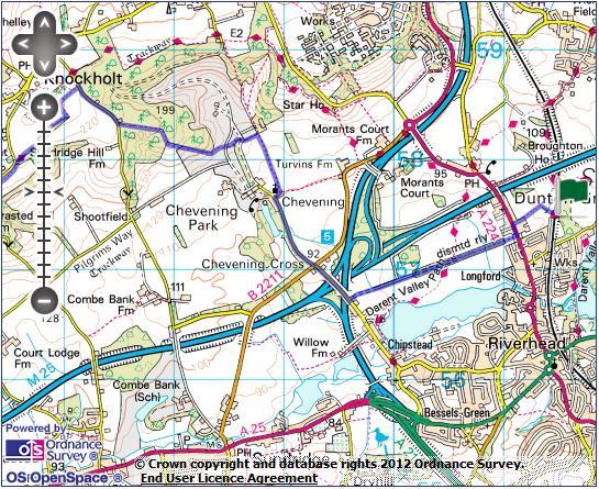
1 1 Chevening and the North Downs Dunton Green station - Chipstead - Chevening - Knockholt - Hawley's Corner - Botley Hill - Oxted station Length: 12 ¼ miles (19.7 km) Underfoot: Portions of the walk are likely to be muddy except after exceptionally dry weather, including the first mile on the disused railway line and pastures used by livestock. However, this is interspersed with plenty of dry paths and minor roads. Good shoes recommended. Terrain: A stiff ascent at Chevening and a similar descent from Botley Hill. The walk along the hilltops in between also has a number of short, sharp climbs and descents. Maps: 1:50,000 Landranger 187 Dorking & Reigate and 188 Maidstone & Royal Tunbridge Wells; 1: Explorer 147 Sevenoaks & Tunbridge and 146 Dorking, Box Hill & Reigate Getting there: Dunton Green is served by 2 Southeastern services an hour (1 an hour on Sundays) from London Charing Cross (47 mins) via Waterloo East (44 mins), London Bridge (39 mins) and Orpington (11 mins) for connections from London Victoria and Bromley South. It can often be quicker to travel on a non-stop express service to Orpington from London Bridge and change at Orpington for the stopper - online journey planners will show when this is the case. Useful websites: Much of this route follows the North Downs Way or the Greensand Way national trails. You pass close to Chevening House, which although not open to the public, has a website. Getting home: Oxted is served, Monday- Saturday, by two trains per hour to London Victoria (39 mins) and one train per hour to London Bridge (32 mins). All trains call at East Croydon (20 mins), for alternative trains to London Bridge or Victoria. On Sundays, Oxted has one train per hour to London Victoria. Fares: The start and end of this walk are on completely separate lines; however, in both cases they are situated only a short distance outside the London Travelcard zones. The cheapest combination of tickets, if travelling from or via central London, is therefore likely to be a zones 1-6 Off Peak Travelcard for 8.50 ( 3.20 child, 5.60 railcard). For the outward journey you will also need a single from Knockholt to Dunton Green for 2.50 ( 1.25 child, 1.65 railcard). For the return you will need a ticket from Oxted to the zone 6 boundary for 3.10 ( 1.55 child, 2.05 railcard).
2 2
3 3
4 4 Route description Arriving at rather scruffy little Dunton Green station from the London direction, cross via the footbridge to the London-bound platform and exit into the car park. Follow the zebra crossing markings to the isolated entrance to a subway - this formerly led under the platforms for the Westerham branch line, but now leads under a suburban garden. The subway brings you out onto tarmac path in an open field, which you follow round to the left to reach the main road by The Dukes Head pub in Dunton Green itself. Cross at the zebra crossing and turn left. Immediately after crossing an old railway bridge, turn right on the path descending and then head leftwards along the cul-de-sac below. At the corner of two roads, keep straight ahead, past a fence and onto a rough path through the trees that have now taken over the former railway line. The former railway on which you are now walking was a 5 mile long branch line running from Dunton Green to the little country town of Westerham, opened by the South Eastern Railway in The section you are walking leads to the site of the first of two intermediate stations - Chevening Halt. The line began to suffer from competition from buses and rising rail fares from the 1930s onwards and the line closed in Various attempts were made by a local group and Kent County Council to restore services to the line, but these came to nothing. Beyond Chevening, much of the trackbed was subsumed by the M25, ending any chance of future re-opening. At one point, a missing bridge forces you to descend steeply to a stream, where informal stepping stones have been provided. Beyond, climb back onto the embankment. Where a footpath crosses the old railway you get a glimpse to the left of Chipstead Lake, a flooded former gravel pit. Beyond here, the old line becomes a long, straight track, gradually getting closer to the motorway. After about 1km, it becomes tarmaced as it approaches the houses of Chipstead, a suburb of Sevenoaks. Pass through a gate to exit onto Chevening Road. Turn left, climbing onto a bridge over the tangle of motorways where the M25 and M26 meet. Beyond, you soon reach the road junction at Chevening Cross. Keep straight ahead on the dead end road towards Chevening church. Follow this quiet road towards the North Downs escarpment ahead. You soon come alongside the brick wall of Chevening Park, with the hamlet's cottages and church tower coming into view shortly afterwards. St Botolph's church is set amongst the handful of picturesque cottages that make up the estate village of Chevening. There has been a place of worship on this site for around 900 years, the village lying just off the Pilgrim's Way, which led along the base of the Downs escarpment to Canterbury. Much of what you can see today dates from the 13th century. Turn right beside the lych gate into the churchyard (footpath sign). At a junction of tarmac paths just beyond the church, turn left, passing through a footgate. Cross the track beyond and take the hedge-lined path ahead.
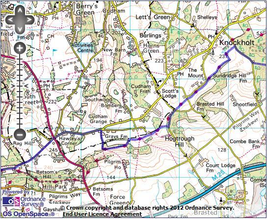
5 5 This pleasant path eventually leads to the corner of a wood, with a little brick cottage just to the right. Here turn left over a stile, following the field edge on the left, across Chevening's parkland. Cross a drive and continue to follow the left hand field boundary. As you cut across the park, a fine view of Chevening House's facade opens up to the left. Chevening House was the family seat of the Earls of Stanhope, designed by Inigo Jones in the 17th century and set amidst a 1,400 hectare estate. It has been suggested that Chevening was the inspiration for Rosings Park, seat of Lady Catherine de Bourgh, in Pride & Prejudice. In 1959, the final Earl Stanhope left Chevening to the management of a board of trustees, an Act of Parliament stipulating that its future resident should be a senior politician or a member of the inner royal family. For a while, it was thought that it would become the home of Prince Charles, but he eventually renounced his claim on it in 1980 and purchased Highgrove House instead. Subsequently, it has become the official rural residence of each Foreign Secretary. Following the formation of the Conservative-led coalition government in 2010, Foreign Secretary William Hague agreed to share Chevening with Deputy Prime Minister Nick Clegg. On reaching the House's drive, turn left across the cattle grid, then immediately follow the waymarks right, beside a fence climbing gently to a wood. Follow the edge of the wood round to a kissing gate, then begin to climb steeply alongside the wood. At the top of the field, a squeeze stile leads you through a belt of trees and then alongside the edge of a meadow. Another stile leads you past a bench, with a fine view across the vale below, and into the woods, along a clear track. Keep straight ahead along this track until you reach Keeper's Cottage and a minor road at the top of Sundridge Hill. Turn right on the road. You pass Knockholt Lodge and climb a short steep section of road. Beyond, a fenced-off track heads left. Immediately after it, look out for a stile hidden on the lefthand bank. Cross to join the North Downs Way (NDW), heading straight ahead on a field-edge track. The North Downs Way, which much of this walk follows, is a 150 mile long long distance path (opened in 1978)running from Dover to Farnham in Hampshire, along the length of the limestone ridge of the Downs, roughly following the route of the Pilgrim's Way. At the end of the field follow the track left, then at the next hedgerow follow waymarks to the right. The path runs along the edge of the wood towards scattered houses on the edge of Knockholt village. On reaching the minor road by these houses, do not cross the stile on to the road but cut left immediately before it, passing through a kissing gate and onto a path along the field edge beside the road. After 3 fields, you emerge on to a road by a T-junction. Cross and take the path opposite (signed as the NDW towards the Kent/Surrey border). Walk straight along the top of the hilltop field, with fine views into Kent behind you, to another T- junction of minor roads. It is best to ignore the muddy NDW route for a short distance here and instead take the road straight ahead. The road drops gently through young woodland before very briefly climbing. At the top of this rise, cut right at a footpath sign.
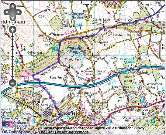
6 6 Through a kissing gate, turn right and after a second gate head immediately left, back on the NDW. At the edge of the wood head left, through a kissing gate. After a few hundred metres, you join a hedged byway past a group of houses. Where this bends sharply right, head left through a kissing gate, back into fields. Walk rightwards along a row of trees. Keep straight ahead through 2 kissing gates into an arable field with fine views ahead along the escarpment. At the end of the field follow NDW waymarks left. Pass through a wooded strip and emerge through a kissing gate onto a steep grassy field, with a panorama across Westerham. Pass through a gate at the end of this field onto a muddy track through trees. Ignore the NDW waymarks pointing left and keep to the track as it swings right. The track soon drops gently past the outbuildings of Gray's Farm to a road. Turn left and follow this road - relatively quiet but quite fast, so take care - as it twists through fields to Hawley's Corner. Surprisingly, given the sylvan setting, you have briefly entered Greater London here. You emerge past an Indian restaurant and thatched Spinning Wheel Cottage onto the A233 at Hawley's Corner. Cross with care and take Tatsfield Lane opposite, immediately veering left on unsurfaced Chestnut Avenue. This long, straight avenue - lined with eponymous chestnut trees - climbs gently over a low hill, past large houses and farms. Descending, you eventually reach a small road junction by a post box. Head right (you are now back on the NDW), passing more hillside houses (including the appropriately decorated Mole End) then pass through woods to a road junction on the busy B2024. Cross the main road and follow the NDW signpost opposite, descending a flight of steps. At the bottom, through a kissing gate, follow waymarks right along the top of a grassy hillside. Halfway through the second field, you join a fenced path which briefly runs alongside the road before beginning to drop. The path cuts downhill across a lovely meadow and into a large wood. You cross a minor road and continue through some more open woodland, before following NDW waymarks dropping steeply to the left. The path turns right to run just above the B269, slowly regaining height. The path emerges onto the road at Botley Hill junction. Cross the road and turn right, then by the roundabout head left downhill through a gate (with byway waymarks), entering the Titsey estate. Titsey Place, a 16th century mansion built by the Gresham family, and substantially rebuilt in the 19th century, lies below the route, and is invisible from this walk. It sits in a huge estate of 3,000 acres, which includes this area of managed woodland on the steep chalk slopes of the Downs. Continue straight ahead on the descending track until the woods end on the righthand side and you can follow a NDW signpost right up some steps.
7 7 You now follow a lovely undulating path along the top of the fields, with huge views south over Oxted to the hills beyond, passing on the way a plaque marking the Greenwich Meridian. At the end of the second field, do not pass through the kissing gate but follow waymarks to the left, downhill towards the motorway. Cross the M25 on a footbridge, from where a path follows the right hand field edge towards the houses of Oxted. Nearing the bottom of the long field, cut left to a footgate. Cross the stile to the left of this gate and join the fenced path past school grounds. Joining a suburban road keep straight ahead. At a T-junction, cross and take a footpath almost opposite between two houses, descending to another road, where you turn right. At the end of this road turn left past the library to reach Oxted's main street. Turn right, uphill along the bustling shopping parade. At the top of the hill, a left turn brings you immediately to the railway station - for trains to London, pass through the subway.
Bewl Water & the High Weald
 1 Bewl Water & the High Weald Stonegate station - Stonegate - Wallcrouch - Newbarn - Cousley Wood - Wood's Green - Wadhurst station Length: 9 ½ miles (15.3km) Underfoot: Large portions of this path are
The Mendip Way. Route Directions and Maps Uphill to Wells
 The Mendip Way Route Directions and Maps Uphill to Wells Website: www.mendiphillsaonb.org.uk Email: mendip@mendiphillsaonb.org.uk Facebook & Twitter: @MendipHillsAONB Phone: 01761462338 1 Uphill to Loxton
Gomshall station - Abinger Hammer - Abinger Common - Friday Street - Leith Hill - Coldharbour - Holmwood station
 1 To Leith Hill Gomshall station - Abinger Hammer - Abinger Common - Friday Street - Leith Hill - Coldharbour - Holmwood station Important note: this walk cannot currently be done on a Sunday due to the
Gomshall station - Abinger Hammer - Abinger Common - Friday Street - Leith Hill - Coldharbour - Holmwood station
 1 To Leith Hill Gomshall station - Abinger Hammer - Abinger Common - Friday Street - Leith Hill - Coldharbour - Holmwood station Important note: this walk cannot currently be done wholly by train on a
Medway Valley Orchards
 1 Medway Valley Orchards East Farleigh station - Kettle Corner - Farleigh Green - Buston Manor - Yalding - Yalding station Length: 6 ¾ miles (10.9km) Underfoot: Generally, this is a walk on good paths,
Hadleigh Castle and Chalkwell Oaze
 1 Hadleigh Castle and Chalkwell Oaze Benfleet station Hadleigh Park Hadleigh Castle Leigh-on-Sea Chalkwell station A short stroll through the lush woods of Hadleigh Park high above the Thames-side marshes,
Mapledurham, Gallowstree and Shepherd s Green
 Mapledurham, Gallowstree and Shepherd s Green Pangbourne station Mapledurham Gallowstree Common Satwell Shepherd s Green Grey s Court Henley-on-Thames Length: 15 ½ miles (24.8km) Underfoot: Minor roads
Ivinghoe Beacon and the Grand Union
 1 Ivinghoe Beacon and the Grand Union Cheddington station - Horton Wharf - Ivinghoe - Ivinghoe Beacon - Bridgewater Monument - Aldbury - Tring station Length: 11 ¼ miles (18.3km) Underfoot: The first mile
Chess & Gade. Chalfont & Latimer Station - Latimer - Chenies - Sarratt - Kings Langley Station. Length: 8 ¾ miles (14.25km)
") 1 Chess & Gade Chalfont & Latimer Station - Latimer - Chenies - Sarratt - Kings Langley Station Length: 8 ¾ miles (14.25km) Underfoot: Well-trodden paths, mainly firm in all weather conditions, though
1 Chess & Gade Chalfont & Latimer Station - Latimer - Chenies - Sarratt - Kings Langley Station Length: 8 ¾ miles (14.25km) Underfoot: Well-trodden paths, mainly firm in all weather conditions, though
BISHOPSTONE CIRCULAR WALK
 BISHOPSTONE CIRCULAR WALK 4½ miles (7¼ km) - allow 2 hours (see maps on final pages) Introduction This walk is within the North Wessex Downs Area of Outstanding Natural Beauty and starts from the small,
Cuxton, Ranscombe and Cobham
 1 Cuxton, Ranscombe and Cobham Cuxton station - Ranscombe - Cobham Park - Cobham - Sole Street station Length: 5 ¾ miles (9.4 km) Underfoot: Most of this walk is on well-made paths or tracks, with a few
BURGHCLERE PARISH RIGHTS OF WAY
 BURGHCLERE PARISH RIGHTS OF WAY Full descriptions compiled by Neill & Miggie Bruce All photos Miggie Bruce FP23 on Ridgemoor, looking south, with FP22 crossing by the bush FP1. From C183 Aldern Bridge
Ystwyth and Rheidol Bridleway Routes. Route 2:Llanilar Circular
 Ystwyth and Rheidol Bridleway Routes Route 2:Llanilar Circular Route overview and terrain: A long circle using connecting ridges with fine views to link the Rheidol and Ystwyth river valleys. The route
Ranmore Common and Polesden Lacey
 point your feet on a new path Ranmore Common and Polesden Lacey Distance: 9½ km=6 miles Region: Surrey Author: Fusszweig Refreshments: Polesden Lacey easy walking Date written: 20-dec-2016 Last update:
Hay Wood, Rowington and Baddesley Clinton - Warwickshire
 Hay Wood, Rowington and Baddesley Clinton - Warwickshire Starts at Lay-by alongside Hay Wood 2 hours 30 minutes 5.5miles 8.8km Leisurely ID: 0.683 Developed by: John Clift Checked by: Andy Page www.ramblersroutes.org
HARDMOORS 55 RACE ROUTE 2018 HELMSLEY - GUISBOROUGH
 HARDMOORS 55 RACE ROUTE 2018 HELMSLEY - GUISBOROUGH HELMSLEY - CHECKPOINT 1 (WHITE HORSE) 1. Leave RACE START, continue ahead on road (Baxtons Sprunt) At crossroads turn right down Canons Garth eventualy
GRINDLEFORD GALLOP 2018
 GRINDLEFORD GALLOP 2018 Route Information The Grindleford Gallop follows a fixed 21 mile route through the lanes and paths of Derbyshire. All competitors must follow this route. An OS map of the area with
Hindhead, Keffolds Copse and Gibbet Hill
 point your feet on a new path, Keffolds Copse and Gibbet Hill Distance: 6 km=4 miles Region: Surrey Author: Schwebefuss Refreshments: Punch Bowl Café moderate walking Date written: 14-apr-2015 Last update:
Reigate Hill and Gatton Park
 point your feet on a new path Reigate Hill and Gatton Park Distance: 11½ km=7 miles easy-to-moderate walking or 2 walks of 6½ km=4 miles and 5½ km=3½ miles Region: Surrey Author: Schwebefuss Refreshments:
Pontfadog. Walk A. Walk A
 Walk A A Bird s eye view of the village 2km. (1 1 /2 miles); height gain 45m. (150ft) about 45 minutes. Six minutes walk along the main road towards Glyn Ceiriog reach a signpost to Llwynmawr. Take the
Singleton and the South Downs
 point your feet on a new path Singleton and the South Downs Distance: 13½ km=8½ miles easy walking with a few steeper sections Region: West Sussex Author: Hautboy Refreshments: Singleton, Hill Barn Date
Beautiful Walks from the Blue Ball Inn
 Walk No. 5 RIVER VALLEYS AND MOOR Countisbury, Watersmeet, Hillsford Bridge, Cheriton, Shilstone Hill, Rockford and Chiselcombe. 8.5 MILES APPROX. Walking time four and a half hours approx. OS 1;25,000
Leaden Boot Challenge ROUTE INSTRUCTIONS
 Leaden Boot Challenge ROUTE INSTRUCTIONS Section 1 Alstonefield to Ilam From the village hall car park turn R then L and pass through the village keeping to the R to enter Church Street. Pass the Church
START - UPHILL BEACH. (tidal!) The West Mendip Way is route-marked with these round blue signs
 The West Mendip Way is route-marked with these round blue signs") START - UPHILL BEACH Start Times: 10:30 11:15 12:00 Please allow sufficient time to check in with the marshals Start on the beach at the high water line (tidal!) The West Mendip Way is route-marked with
START - UPHILL BEACH Start Times: 10:30 11:15 12:00 Please allow sufficient time to check in with the marshals Start on the beach at the high water line (tidal!) The West Mendip Way is route-marked with
HARDMOORS ROUTE DESCRIPTION
 HARDMOORS 60 2016 ROUTE DESCRIPTION RACE START (GUISBOROUGH) - CHECKPOINT 2 (SALTBURN) DISTANCE 9 MILES CUT OFF TIME 1030 GRID REF OS 666 208 1. Leaving the Sea Cadets Hall, turn left onto the road and
Leaden Boot Challenge 2016 ROUTE INSTRUCTIONS
 Leaden Boot Challenge 2016 ROUTE INSTRUCTIONS Section 1 Alstonefield to Ilam (CP2) From the village hall car park turn R then L and pass through the village keeping to the R to enter Church Street. Pass
Bentley station - Alice Holt Forest - Frensham Great Pond - Rushmoor - Pitch Place - Gibbet Hill - Haslemere station
 1 Devil s Punch Bowl and Surrey Heaths Bentley station - Alice Holt Forest - Frensham Great Pond - Rushmoor - Pitch Place - Gibbet Hill - Haslemere station Length: 13 ¾ miles (22.0 km) Underfoot: Almost
Slad over to Pitchcombe and back
 The walk climbs up from Slad over Wickridge Hill, descends to near Pitchcombe, then climbs back over Wickridge hill and round the back of Slad. Page 1 Start Point: SO 8718 0732 The Woolpack, Slad Length:
Beautiful Walks from the Blue Ball Inn
 Walk No. 2 WINSTONS WALK Countisbury, Wind Hill, Watersmeet, Ash Bridge and Winston s path. 5 Miles approx. Walking time- Two and a half hours approx. (Not including Breaks) OS 1:25,000 Sheet 64/74 Lynton
CWMGIEDD FROM ABERCRAVE
 Abercrave to Cwmgiedd Walk Page 1 Starting from The Abercrave Inn. Grid Ref: SN 824128 From the Abercrave Inn, an 11.3km (7 miles) walk to the foothills of the Cribarth Mountain, then through forest to
Ardingly Lake, Ouse Valley, Borde Hill
 point your feet on a new path Ardingly Lake, Ouse Valley, Borde Hill Distance: 14 km=9 miles or 12½ km=8 miles Region: West Sussex Author: Hautboy Refreshments: Borde Hill Map: Explorer 135 (Ashdown Forest)
Walk 1. Cotswold Water Park. Gateway Centre to Cerney Wick, railway track to Lake 6, Gateway Centre.
 Cotswold Water ark Walk way A Swindon/ Cirencester Thomas and Severn Canal way to Cerney Wick, railway track to Lake, way. Spine Road East Hotel Time: hours (short walk km) Distance: km A level walk along
Basingstoke Canal and Dogmersfield
 point your feet on a new path? Basingstoke Canal and Dogmersfield Distance: 11 km=7 miles easy ing or 2 s of 7½ km=4¾ miles and 5¼ km=3¼ miles Region: Hampshire Author: Botafuego Refreshments: The Barley
Freefolk and Whitchurch
 Trail Activity Type Terrain Author Distance Ascent Location : HAMPTR0026 : Walk : Tea Shop : Towpaths and Cycle Tracks : Jean Patefield : 5.6 miles / 9 kms : 377 feet / 115 metres : SU487488 / RG28 7NN
Fetcham Downs and Bocketts Farm A magical teashop walk
 point your feet on a new path Fetcham Downs and Bocketts Farm A magical teashop walk Distance: 3 km=2 miles or 4 km=2½ miles Region: Surrey Author: Fusszweig Refreshments: Bocketts Farm easy walking Date
ID: 283 Distance: 6.2 miles Height gain: 500 Metres Map: Explore OL 19 Contributor David and Chris Stewart
 Walkingworld Wild Boar Fell ID: 283 Distance: 6.2 miles Height gain: 500 Metres Map: Explore OL 19 Contributor David and Chris Stewart Features Birds, Great Views, Hills or Fells Description: Wild Boar
The 34 th Poppyline Marathon
 The 34 th Poppyline Marathon Saturday 9th June 2018 - Route Description Emergency number: 07906 404673 or 07597 052572 Ahd - Ahead BL - bear left BR - bear right BW - bridleway Cont - continue FB - footbridge
Description for the Round Rotherham 8 December 2007
 Directions: L left R right ½L, ½R half left, half right X cross X Rds cross roads SA straight Codes: BR bridge FP footpath FB footbridge RWY railway CP car park RD road Description for the Leave Event
3.1 Bowness-on-Solway to Carlisle
 3.1 Bowness-on-Solway to Carlisle Map panel 1 Distance 15 miles (24 km) Terrain minor roads, tracks, field paths and riverside footpath, muddy in places Grade easy, with gentle gradients on undulating
Friday Street, Leith Hill, Holmbury Hill
 point your feet on a new path Friday Street, Leith Hill, Hill Distance: 12 km=7 miles easy-to-moderate walking + optional tour of Hill: 1½ km=1 mile Date written: 27-oct-2011 Region: Surrey Author: Schwebefuss
Woodland Walk If you enjoyed this walk there are two others available in the same area.
 The Woodland Walk 11-12 kilometres (7-8 miles) 4-5 hours Terrain: some easy hills Can be slippery when wet 5 stiles Unsuitable for a pushchair/wheelchair Uses OS map 197 Parking: Pulborough Station and
The Hundred Parishes
 The Hundred Parishes Walks from railway stations number 3 3 miles (5kms) circular walk from Stansted Mountfitchet Start & finish: Stansted Mountfitchet station. Ordnance Survey Explorer Map 195. Grid Reference:
Sponsored by. statestreet.com
 /STATESTREETISLANDWALK #ISLANDWALKJSY Sponsored by statestreet.com Important Information If you forget everything else PLEASE remember the following.» Remember to check OUT of every checkpoint» If you
Penn Common and Bramshaw Wood
 Trail Activity Type Terrain Author Distance Ascent Location : HAMPTR0025 : Walk : Pub : Towpaths and Cycle Tracks : Anne-Marie Edwards : 5.3 miles / 8.5 kms : 381 feet / 116 metres : SU253173 / SP5 2BZ
Bentley and Isington Mill Lower Froyle: The Anchor
 point your feet on a new path and Isington Mill Lower Froyle: The Anchor Distance: 12 km=7 miles Region: Hampshire Author: Botafuego Refreshments: Lower Froyle, easy walking Date written: 6-may-2012 Date
Baggy Point, Croyde, North Devon
 Baggy Point, Croyde, North Devon A walk using the South West Coast Path that is likely to be suitable for people with impaired mobility or with a pushchair, wheelchair, or mobility scooter. The Coast Path
landcapes and romance Artists and poets have been inspired by the idyllic scenes of picturesque Kent villages sheltered by rolling, chalk hills.
 landcapes and romance Artists and poets have been inspired by the idyllic scenes of picturesque Kent villages sheltered by rolling, chalk hills. WALK 4 41 41 WALK 4 42 Pond Location: Distance: 5 miles
Lewes and the South Downs
 point your feet on a new path and the South Downs Distance: 0 km=1½ miles moderate walking with long easy stretches Region: East Sussex Author: Hautboy Refreshments: Date written: 8-apr-013 Map: Explorer
Britain s oldest surviving water-balanced cliff lift
 44 3.6 Saltburn by the Sea to Sandsend Map panels 3 and 4 Distance 17 miles (27½ km) Terrain mostly grass and field paths which can be muddy; some pavement, beach and shore Grade undulating route, with
Mersey Valley Timberland Trail
 Route Pack Page 1 Route Summary A long distance linear walk on roads and country paths linking town and countryside to parks, woodlands and other open spaces. Grade Distance Accessibility Allow Start Map
River Isla B951. Diarmid s Tomb
 3. 4 Spittal of Glenshee to Kirkton of Glenisla Distance 14.6 miles 23.5 km Terrain mainly on rough moorland path with boggy bits and stream crossings, then heading east along at the B951 for 2.5 miles,
Aston Rowant Discovery Trail
 The walk was developed by Aston Rowant Parish Council. The Trail is stile-free and fully way-marked. The circular route is 5.3m but with the extension to a pub and hotel 6.2m. Key Main Aston Rowant Discovery
Orchards and oasts a taste of the Garden of England
 49 Orchards and oasts a taste of the Garden of England Open parkland, orchards, oasts and incredible panoramic views over the Weald to the South Downs make this a truly memorable walk. Linton Village 50
COSTA BLANCA MOUNTAIN WALKERS - WALK DESCRIPTION. Visit for more walks descriptions in Spain
 Visit www.walksinspain.org for more walks descriptions in Spain Walk description originally prepared by:- Ralph Phipps Last Updated 15 th July 2016 Title of Walk Location of Start (include name of nearest
Map: Landranger #27 Forres and Nairn and 36 Grantown and Aviemore
 THE DAVA WAY This is a newly created long distance route that runs from Forres to Grantown, mostly following the old railway line. You will need to detour around a couple of sections that are not really
beach. Make the ford and follow the trail out to the junction with Red Creek Tr in an open grassy area.
 Description: This is a moderate to slightly strenuous 22.8 mile backpack (add 2.6 miles if you do the packless out and back to the Lion s Head) that will have you exploring nearly every thing that is The
The Sudbury Branch Walks 1-4
 The Sudbury Branch Walks 1-4 Sudbury Branch Walks From Sudbury to Marks Tey The gentle declivities, the luxuriant meadow flats sprinkled with flocks and herds... the sound of water escaping from the mill
s point your feet on a new path
 s point your feet on a new path Arundel: Park, Hills and Forests Distance: 20 km=12½ miles Region: West Sussex Author: Hautboy Refreshments: Arundel, Houghton, Whiteways Lodge moderate walking Date written:
Merritts Traverse. 1928m
 Merritts Traverse 3 hrs Hard track 5.8 km Circuit 4 167m This walk starts with a scenic journey to the top of the hill on the chairlift. Starting along Merritts Nature walk, this walk soon detours down
This path goes past an old tree nursery and sawmill. After 800m it crosses over a lane. Follow the bridleway fingerpost into the woods.
 FRENSHAM PONDS 11K CIRCULAR TRAIL 2½ HRS GU10 2DA This magnificent heathland trail starts in woodland and then brings you out onto the open heather of Frensham Common, with no roadwork! The route runs
The Bridestone Rocks from Lydgate
 Print this page Back to results The Bridestone Rocks from Lydgate Ancient tracks and gritstone outcrops, with terrific views of the steepsided Cliviger Valley. Distance 5 miles (8km) Minimum time 2hrs
Pangbourne, Mapledurham and The Thames
 Trail Activity Area Type(s) Author Distance Ascent Location : BRKSTR0003 : Walk : The River and Reading : Country Escape : D Scott : 5.7 miles / 9.1 kms : 66 feet / 20 metres : SU634765 / RG8 7AN Whitchurch
Eastbourne. Alfriston 3¾ 6 3¾ 6. Birling Gap. Exceat
 3.8a Alfriston to Eastbourne (footpath) Map panel 6 (page 64) Distance 10½ miles (17 km) Terrain valley walk initially, first along riverbank path then hillside paths above, including stretch through forest;
Mt Kuring-gai Track to Berowra station
 Mt Kuring-gai Track to Berowra station 4 hrs 15 mins 9.7 km One way Hard track 4 553m This walk explores three valleys, with great displays of wild flowers in spring, and some nice sandstone overhangs.
Brightling, Dudwell Valley, Bateman s Forests and Follies
 point your feet on a new path Brightling, Dudwell Valley, Bateman s Forests and Follies Distance: 15 km=9½ miles Region: East Sussex Author: Stivaletti Refreshments: Woods Corner, Burwash Weald moderate
Walk 1: Highfield, Lob Wood and The River Wharfe
 Walk 1: Highfield, Lob Wood and The River Wharfe Start: The Hen Pen Garden, Main Street, Addingham LS29 0NS, SE 077 498. Alternative Start: Near Bolton Bridge SE 071 525 (see page 6). Full walk: 4.5 miles
Black Hill Regional Park, Little Seneca Lake
 Black Hill Regional Park, ittle Seneca ake ittle Seneca ake, in Black Hill Regional Park, is a reservoir created after a previous drought struck the Washington area. The park is under Maryland-National
Approximate distance: 7.5 miles For this walk we ve included OS grid references should you wish to use them.
 Approximate distance: 7.5 miles For this walk we ve included OS grid references should you wish to use them. 6 5 7 8 4 1 2 Start End N 3 W E S Reproduced by permission of Ordnance Survey on behalf of HMSO.
Beamers Trail. Walk No.1. 6 miles. (easy with some moderate ascents and descents)
") Beamers Trail Walk No.1 6 miles (easy with some moderate ascents and descents) 1 BEAMERS TRAIL 6 miles (easy with som WALK The Warpers Trail forms part of the long distance Witton Weavers Way. This is
Beamers Trail Walk No.1 6 miles (easy with some moderate ascents and descents) 1 BEAMERS TRAIL 6 miles (easy with som WALK The Warpers Trail forms part of the long distance Witton Weavers Way. This is
Self-Guided Walk Langdale Pikes. Start & Finish: NT car park (free to members) at Sticklebarn - on the right just beyond the New Dungeon Ghyll hotel.
 at Sticklebarn - on the right just beyond the New Dungeon Ghyll hotel.") Self-Guided Walk Langdale Pikes Key Information These mountains form a collection of spires and cliffs on the north side of Langdale. This walk visits four of the main tops Pavey Ark, Harrison Stickle,
Self-Guided Walk Langdale Pikes Key Information These mountains form a collection of spires and cliffs on the north side of Langdale. This walk visits four of the main tops Pavey Ark, Harrison Stickle,
Tour Of Tameside The alternative tameside trail
 Tour Of Tameside The alternative tameside trail A 30 mile walk around the borough of Tameside taking in the Valleys of the Medlock, Etherow and Tame. The whole walk can be completed in one day by anyone
Distance: 18 km=11 miles or 12½ km=7½ miles or 9 km=5½ miles
 point your feet on a new path The Devil s Dyke Distance: 18 km=11 miles or 12½ km=7½ miles or 9 km=5½ miles Region: West Sussex Author: Hautboy Refreshments: Devil s Dyke, Fulking, Poynings moderate ing
Countryside Trails Dunkeld
 R A N G E R S E RV I C E Countryside Trails Dunkeld WELCOME Welcome to this southern end of Atholl Estates. The countryside here is a wonderful blend of lochs, woodland and heather moor. There is a large
Kingley Vale and the Downland Churches
 point your feet on a new path Kingley Vale and the Downland Churches Distance: 21 km=13 miles or 10½ km=6½ miles Region: West Sussex Author: Hautboy Refreshments: Stoughton, Walderton moderate walking
Much of the information which follows is included by kind permission of the Tynedale Council (now defunct) and is based on its brochure.
 and is based on its brochure.") The Tyne Green Trail This easy going circular walk is on level ground throughout. It follows the course of the River Tyne between Hexham Bridge and the turning point just past Watersmeet. The return is
The Tyne Green Trail This easy going circular walk is on level ground throughout. It follows the course of the River Tyne between Hexham Bridge and the turning point just past Watersmeet. The return is
PLACES TO VISIT FROM SAN FRANCISCO, 71 IN DISTANCE ORDER (distance and driving times are approximate)
") PLACES TO VISIT FROM SAN FRANCISCO, 71 IN DISTANCE ORDER (distance and driving times are approximate) 1. Rio Chillar 2 km, 4 mins A peaceful walk close to the apartment. The Rio Chillar eventually flows
PLACES TO VISIT FROM SAN FRANCISCO, 71 IN DISTANCE ORDER (distance and driving times are approximate) 1. Rio Chillar 2 km, 4 mins A peaceful walk close to the apartment. The Rio Chillar eventually flows
The Hastings Line 2017 Capital-to-Coast Walk Information Pack
 The Hastings Line 2017 Capital-to-Coast Walk Information Pack This information pack is available online at https://ralphpalfreywalks.wordpress.com/ (or search for 'palfreywalks'). Paper copies are available
Victoria Falls Lookout to Blue Gum Forest
 Victoria Falls Lookout to Blue Gum Forest 8 hrs Experienced only 13.8 km One way 5 112m This long day-walk follows a remote track down from Victoria Falls lookout, passing the waterfall, and into the Grose
Aeron & Arth walks 4 walks for all the family to enjoy
 Aeron & Arth walks walks for all the family to enjoy Please take note that the maps illustrating these walks are intended as a rough guide only. You should use the most recent version of the relevant Ordnance
Darwin s gigantic blunder
 Trail Darwin s gigantic blunder Explore how ice shaped the landscape and why Charles Darwin made a nice mess of Glen Roy Time: 1hr 10 mins Distance: 2 miles Landscape: rural At Glen Roy a curious feature
Approximate distance: 4.5 miles For this walk we ve included OS grid references should you wish to use them. Start. End
 Approximate distance: 4.5 miles For this walk we ve included OS grid references should you wish to use them. 2 1 Start End 4 3 N W E S Reproduced by permission of Ordnance Survey on behalf of HMSO. Crown
Victoria Falls and Grose Valley to Blackheath Station
 This walk explores a fantastic section of the Grose Valley. Starting above Victoria Falls, the walk explores the cascades before dropping into the valley for the first nights rest at Burra Korain campsite.
river point your feet on a new path
 river point your feet on a new path Frensham and Bourne Wood Distance: 13 km=8 miles or 11 km=7 miles easy walking with a few steep gradients Region: Surrey Author: Schwebefuss Refreshments: Shortfield
Broxbourne Woods Brickendon, Ermine Street, Wormley West End
 point your feet on a new path Broxbourne Woods Brickendon, Ermine Street, Wormley West End Distance: 10 km=6 miles (+ 1.2 km=0.8 mile for north pub) easy walking or two walks of 7 km=4½ miles (south) and
Congewai Track Head (East) to Watagan Headquarters
 to Watagan Headquarters") Congewai Track Head (East) to Watagan Headquarters 7 hrs Hard track 17.2 km One way 4 973m This full day walk starts from the Congewai valley trackhead (east) and follows the Great North Walk up into the
Congewai Track Head (East) to Watagan Headquarters 7 hrs Hard track 17.2 km One way 4 973m This full day walk starts from the Congewai valley trackhead (east) and follows the Great North Walk up into the
Torrance. Mapped Heritage. The following maps demonstrate the spatial strategy for the Torrance trails. Trail themes
 Torrance The following maps demonstrate the spatial strategy for the Torrance trails. The heritage and proposed trails are presented on two maps per area: Map 2A - Existing heritage locations Map 2B -
San Miguel to Caserio de la Hoya Circular (San Miguel)
") Tenerife Sur: Short Walks Under 10 km San Miguel to Caserio de la Hoya Circular (San Miguel) Route Summary An informative and scenic walk back in time from San Miguel to below El Roque, overlooking the
Tenerife Sur: Short Walks Under 10 km San Miguel to Caserio de la Hoya Circular (San Miguel) Route Summary An informative and scenic walk back in time from San Miguel to below El Roque, overlooking the
Jerusalem Bay Track (Cowan to Brooklyn)
") Jerusalem Bay Track (Cowan to Brooklyn) 5 hrs 30 mins 13.4 km One way Hard track 4 654m This Cowan to Brooklyn Station walk is a popular section of the Great North Walk, with scenery ranging from foreshore
Jerusalem Bay Track (Cowan to Brooklyn) 5 hrs 30 mins 13.4 km One way Hard track 4 654m This Cowan to Brooklyn Station walk is a popular section of the Great North Walk, with scenery ranging from foreshore
Centurion Way Chichester
 Centurion Way Chichester Work book of plans to show details of the Centurion Way, its links, and potential developments and enhancements from linking to the South Downs National Park all the way to the
White Horse Trail Route directions (Clockwise) split into 10 section with an alternative for the Alton Barnes to Cherhill section
 split into 10 section with an alternative for the Alton Barnes to Cherhill section") White Horse Trail Route directions (Clockwise) split into 10 section with an alternative for the Alton Barnes to Cherhill section S1 White Horse Trail directions Westbury to Bulkington Maps: OS Explorer
White Horse Trail Route directions (Clockwise) split into 10 section with an alternative for the Alton Barnes to Cherhill section S1 White Horse Trail directions Westbury to Bulkington Maps: OS Explorer
The. History Walk. WWII Armaments factory
 The History Walk WWII Armaments factory 4.8-6.5 kilometres (3-4 miles) 2.5-3.5 hours Terrain: easy Can be slippery when wet No stiles Unsuitable for a pushchair/wheelchair Uses OS map 197 Parking: Pulborough
A Circular Walk from Chapel Carn Brea
 A Circular Walk from Chapel Carn Brea 4.3 Miles A Walk Visiting Five Historic Ancient Sites This circular walk offers the possibility of several alternatives, depending on the walker s available time and
Approximate distance: 5.5 miles For this walk we ve included OS grid references should you wish to use them. Start. End
 Approximate distance: 5.5 miles For this walk we ve included OS grid references should you wish to use them. Start End 2 1 5 4 6 3 N W E 7 S Reproduced by permission of Ordnance Survey on behalf of HMSO.
H U D S O N P A L I S A D E S
 14 H U D S O N P A L I S A D E S Hudson Palisades The southernmost sections of the Long Path follow the Hudson River and the Hudson Palisades north, staying close to the river and to civilization. Although
Road Signs, Markings and Their Meaning
 Road Signs, Markings and Their Meaning FUNCTIONS OF ROAD SIGNS AND MARKINGS 1. Guides 2. Directs 3. Warns 4. Informs 5. Prohibits 6. Regulates CLASSIFICATION OF ROAD SIGNS 1. Warning 2. Regulatory 3. Informatory
Access Statement for Leighton Hall
 Access Statement for Leighton Hall Introduction Leighton Hall is located 3 miles from J35 of the M6. Brown tourism signs are in situate to bring you right to the door. There is plenty of parking, with
TREK TO ANCIENT PETRA
 JORDAN TREK DEMANDING ABOUT THE CHALLENGE This challenging and adventurous trek takes us through unique landscapes in one of the friendliest countries in the world, ending at the impressive rock-hewn facades
Girrakool to Wondabyne station
 Girrakool to Wondabyne station 4 hrs Hard track 9.5 km One way 4 438m This walk starts from the Girrakool picnic area and winds south, through the Brisbane Waters National Park. The walk crosses some long
Tenerife Sur: Short Walks Under 10 km. Casa del Ancon Circular (Arona) Route Summary. Route Overview. Description
 Route Summary. Route Overview. Description") Tenerife Sur: Short Walks Under 10 km Casa del Ancon Circular (Arona) Route Summary This short circular walk from Arona is very scenic, with reminders of rural life in previous times. Route Overview Duration:
Tenerife Sur: Short Walks Under 10 km Casa del Ancon Circular (Arona) Route Summary This short circular walk from Arona is very scenic, with reminders of rural life in previous times. Route Overview Duration:
A novel character. Discover what shaped the landscape that so inspired the Brontës. Directions
 Trail A novel character Discover what shaped the landscape that so inspired the Brontës Time: 1-1 ½ hrs Distance: 1 ½ miles Landscape: rural The small village of Haworth in West Yorkshire is most famous