Cuxton, Ranscombe and Cobham
|
|
|
- Esmond Stewart
- 5 years ago
- Views:
Transcription
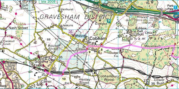
1 1 Cuxton, Ranscombe and Cobham Cuxton station - Ranscombe - Cobham Park - Cobham - Sole Street station Length: 5 ¾ miles (9.4 km) Underfoot: Most of this walk is on well-made paths or tracks, with a few short stretches of road walking. You may encounter a little mud after wet weather, but the route should generally be easy going. Terrain: This is rolling countryside, so expect a few steady climbs: these are almost entirely in the first couple of miles of the walk, in the Ranscombe area. Maps: 1:50,000 Landranger 178 Thames Estuary; 1:25,000 Explorer 148 Maidstone & the Medway Towns. Useful websites: The walk passes through the Ranscombe nature reserve, through Cobham Wood and the Darnley Mausoleum and the historic village of Cobham. Getting home: Sole Street has an hourly direct service to London Victoria every day of the week, taking around 53mins, via Bromley South and Denmark Hill (not Sundays) for London Overground connections. Fares: As the start and end points are on two separate lines, you need to buy two tickets to cover all the journeys. The cheapest combination is to buy a Super Off Peak Day Return to Rochester for (child 9.65, railcard 12.75), which will cover you for the outward journey as far as Strood and all the return journey. Note that if you take the slower route from Charing Cross/Waterloo East/London Bridge to Strood, you can purchase a 'Not HS1' fare that is a couple of pounds cheaper. You will also need a Strood to Cuxton single for the last leg of the outward journey, for 2.80 (child 1.40, railcard 1.85) Getting there: Cuxton is situated on the Medway Valley line, which runs between Strood and Tonbridge, meaning it is always necessary to change trains to arrive from London. The fastest route is to take the high-speed service from London St Pancras, via Stratford International for connections to the DLR and change at Strood for the one-stop hop to Cuxton. Both the high-speed trains and the Medway Valley trains run every half hour (hourly on Sundays), with a total journey time from St Pancras of around 43 minutes. Alternatively, slower services run every half hour from London Charing Cross, Waterloo (East) and London Bridge, via Lewisham and Woolwich Arsenal both for connections to the DLR. Total journey time from Charing Cross is around 1hr 29mins.

2 2
3 3 Route description Alighting at Cuxton from the Strood direction, walk to the end of the platform by the level crossing (a rare survivor where the gates are still opened and closed manually by the signalman) and turn left towards the marina, then immediately left again onto a narrow footpath. The path runs between fences, squeezed between the railway line and the marina - the first ten minutes or so of this walk are not hugely inspiring, but persevere: the good stuff comes soon enough. After about 500 metres, the path swings left under a railway bridge. On the far side, bear immediately right to continue to shadow the railway line north-eastwards. Sadly, the nearby presence of a rubbish tip makes itself felt around here, but you soon pass through a green kissing gate onto a track (1). Head left on the track, which quickly becomes a tarmaced road passing through a small park of mobile homes and then climbing steadily to reach the busy A228. Turn right along the verge of the main road, passing the entrance to Brickfields Farm. Having passed over a railway on a brick railway bridge, use the traffic island to cross the road with care to the entrance to Ranscombe Farm Reserve. Pass through the small car park and keep ahead on the minor road past the information signs for the reserve. Ranscombe Farm is a 620-acre reserve of woodland, farmland and grassland, spreading along the slopes above the Medway, a broad ledge of fields, and then densely wooded hills above them. It is managed by the charity Plantlife with particular emphasis on conserving the wide range of wildflowers and other plants that thrive here, with the farmed portions of the reserve incorporating hedgerows and broad field margins. Ranscombe provides habitats for a wide range of orchids, and less romantically but no less importantly, for as much as 95% of Britain's population of broad-leaved cudweed. As you walk through the reserve, you'll find plenty of information boards pointing out key habitats and land management techniques. Follow the road round the bend and begin to climb, with views opening up over the Medway valley, including the viaducts carrying the M2 and the high-speed railway to the Channel Tunnel over the estuary. At a waymark sign (2), turn left, leaving the road, on a fine chalk track along the foot of Longhoes Wood. The path eventually swings leftwards to descend steps to a path junction by the railway line (3). Turn right on a clear path climbing through the woodland. The path eventually exits the wood onto a ridge with an open field beyond. Keep straight ahead on the clear path over the field, in the direction of the buildings of Ranscombe Farm. On reaching a track by a waymark post, turn left (this is the North Downs Way). The track cuts through a narrow belt of woodland, on the other side once again giving views down the wide valley towards Maidstone. The track descends as it steadily heads west away from the Medway valley. At a waymark post (4), head right, leaving the North Downs Way on a nature reserve track, climbing again, into open fields, popular with soaring skylarks. At the top of the hill you get a panorama over the oast house roofs at Ranscombe to the towers of Rochester castle and cathedral and onwards to the container cranes at Thames Gateway port on the opposite side of the Thames estuary.
4 4 At a track junction, follow the waymark left on a hedge side track towards the large expanse of Birch Wood and Great Wood ahead. At the corner of the wood (5), head left on a waymarked path following the southern edge of the trees, running between wooden fences. At a path junction by a bench and information board, keep ahead along the forest edge. Passing a dogleg in the path, keep straight ahead again past two kissing gates on the left hand side and a path off to the right. A short distance further on you reach a path junction (6) by a third kissing gate - here head right on a path climbing steadily through the trees. At the top of the hill, you reach a broad path running along the ridge line at a waymark post (7). Head left along the ridge, immediately passing through a gate to enter the National Trust land at Cobham Wood. You are quickly in a very different landscape of scattered large trees among the grazed bracken of the former deer park of Cobham House. After about 400m, you come to the clearing housing the Darnley mausoleum. It is something of a surprise to find this Grade 1-listed pyramid-roofed, classical temple on this grassy hilltop. Built in 1786, to a design by fashionable architect James Wyatt, it was meant to be the internment place for future generations of Earls of Darnley, owners of Cobham Hall - they had previously been buried in Westminster Abbey, but space had run out. However, the mausoleum was never consecrated and the crypt underneath the temple (and its 32 coffin shelves) remained unused. With the redesign of the parkland, the mausoleum became a landscape feature, and after the sale of Cobham Hall went into decline, subject to vandalism. From 2001, the mausoleum and park were restored, with a Lottery grant and funding from the builders of the Channel Tunnel Rail Link - the mausoleum is now in the hands of the National Trust, who open it to visitors on the first Sunday of each month. The 190 acres of parkland around the mausoleum comprise mainly of 'wood pasture', non-intensively grazed woodland - now a very rare landscape type, but which would have been very typical of prehistoric lowland southern England: a mixture of open grassland and mature trees. As you descend, you will find many historic oak trees, leaving behind the sweet chestnuts and hornbeams of the upper slopes. Past the mausoleum continue on the broad path descending gently through the woodland. Eventually the route, now a broad track, leaves the trees at a gateway, and runs alongside a fine hawthorn hedgerow. Ignore paths signed off to either side and continue ahead to reach Lodge Farm. Just before you reach its thatched lodge house, you get glimpses of Cobham Hall through trees to the right. There has been a manor house on the site since the 12th century, but Cobham Hall was much expanded in both the 17th and 18th centuries. Originally home to the Barons of Cobham, it became the family seat of the Earls of Darnley and remained in this use until the 1950s. It subsequently became a private girls' school, and remains in this use today. On reaching Lodge Farm, and passing through a kissing gate by a tiny orchard, continue ahead on the minor road in the same direction of travel (west). Follow this byway for around 600m to reach Cobham's war memorial (8). Just to the right, as you approach the memorial, is the end of a fine avenue of trees leading from Cobham Hall. At the mini roundabout by the memorial, take the road ahead (The Street) signed to Cobham and Sole Street.
5 5 The Street leads into the village of Cobham, past the Ship Inn, the fine 19th century village school, the village store, the Darnley Arms and finally the church, with the Leather Bottle inn opposite. Cobham is a picturesque little village, still containing many weatherboarded and half-timbered buildings - in total, the village has over 450 listed buildings. The thirteenth century church of St Mary Magdalen has one of the country's best collections of medieval brasses, fifteen of which form the floor of the chancel. Remarkably, this little village still contains three operational pubs, the oldest of which - the Darnley Arms - dates from and allegedly has one end of a bolt hole for priests from the ecclesiastical college behind the church. The Leather Bottle inn, opposite the churchyard, is a fine medieval half-timbered building which trades on its associations with Charles Dickens. The author was a frequent patron of the Leather Bottle and would often stay here before he purchased Gads Hill in nearby Higham. Cobham features in The Pickwick Papers and the Leather Bottle itself is where Tracy Tupman flees to after being jilted by his sweetheart Rachel Wardle - described as 'a clean and commodious ale house'. Head left along the diagonal path through the churchyard (following Public Footpath signs to Luddesdown and Gold Street). Passing the front door of the church, keep ahead on the earth path around the side, with Cobham College just behind the church. Leave the churchyard on a broad, descending path. At the bottom of the slope (9), turn right, along the edge of a graveyard extension, to a kissing gate. Beyond the gate, take the lefthand of the two waymarked paths, heading diagonally across the field towards a large orchard ahead. This leads to a clear path cutting through the apple trellises. Continue ahead across a track, through a windbreak line of trees and across what is currently a grubbed-up orchard, passing under a pair of electricity lines. Another orchard follows. The path curves leftwards across a broad track and continues through the trellises. Ignore a path waymarked to the right and keep ahead along the angled path, passing through a further windbreak to reach a kissing gate out onto a small road. Cross straight over the lane and onto a path through a further orchard. At the bottom of this orchard a metal footbridge leads you over the railway. Beyond the bridge, keep ahead on the clear path heading over the field ahead towards an electricity line. Just before the brow of the slight hill (10), head right on a path (no sign) which comes across the field at a right angle (note: find what is clearly a footpath, rather than any tractor routes through the crops). The path runs straight across the field towards the outlying houses of Sole Street and a waymark post on the hedgeline ahead. At the post, keep straight ahead through the gap in the hedge onto a fenced path. This emerges on a road opposite the Railway Inn. For Sole Street station, cross and take the road ahead down to the entrance. London trains depart from the platform on this side of the line.
Bewl Water & the High Weald
 1 Bewl Water & the High Weald Stonegate station - Stonegate - Wallcrouch - Newbarn - Cousley Wood - Wood's Green - Wadhurst station Length: 9 ½ miles (15.3km) Underfoot: Large portions of this path are
Hadleigh Castle and Chalkwell Oaze
 1 Hadleigh Castle and Chalkwell Oaze Benfleet station Hadleigh Park Hadleigh Castle Leigh-on-Sea Chalkwell station A short stroll through the lush woods of Hadleigh Park high above the Thames-side marshes,
Chevening and the North Downs
 1 Chevening and the North Downs Dunton Green station - Chipstead - Chevening - Knockholt - Hawley's Corner - Botley Hill - Oxted station Length: 12 ¼ miles (19.7 km) Underfoot: Portions of the walk are
Medway Valley Orchards
 1 Medway Valley Orchards East Farleigh station - Kettle Corner - Farleigh Green - Buston Manor - Yalding - Yalding station Length: 6 ¾ miles (10.9km) Underfoot: Generally, this is a walk on good paths,
The Mendip Way. Route Directions and Maps Uphill to Wells
 The Mendip Way Route Directions and Maps Uphill to Wells Website: www.mendiphillsaonb.org.uk Email: mendip@mendiphillsaonb.org.uk Facebook & Twitter: @MendipHillsAONB Phone: 01761462338 1 Uphill to Loxton
Hay Wood, Rowington and Baddesley Clinton - Warwickshire
 Hay Wood, Rowington and Baddesley Clinton - Warwickshire Starts at Lay-by alongside Hay Wood 2 hours 30 minutes 5.5miles 8.8km Leisurely ID: 0.683 Developed by: John Clift Checked by: Andy Page www.ramblersroutes.org
BURGHCLERE PARISH RIGHTS OF WAY
 BURGHCLERE PARISH RIGHTS OF WAY Full descriptions compiled by Neill & Miggie Bruce All photos Miggie Bruce FP23 on Ridgemoor, looking south, with FP22 crossing by the bush FP1. From C183 Aldern Bridge
BISHOPSTONE CIRCULAR WALK
 BISHOPSTONE CIRCULAR WALK 4½ miles (7¼ km) - allow 2 hours (see maps on final pages) Introduction This walk is within the North Wessex Downs Area of Outstanding Natural Beauty and starts from the small,
Gomshall station - Abinger Hammer - Abinger Common - Friday Street - Leith Hill - Coldharbour - Holmwood station
 1 To Leith Hill Gomshall station - Abinger Hammer - Abinger Common - Friday Street - Leith Hill - Coldharbour - Holmwood station Important note: this walk cannot currently be done on a Sunday due to the
Mapledurham, Gallowstree and Shepherd s Green
 Mapledurham, Gallowstree and Shepherd s Green Pangbourne station Mapledurham Gallowstree Common Satwell Shepherd s Green Grey s Court Henley-on-Thames Length: 15 ½ miles (24.8km) Underfoot: Minor roads
Gomshall station - Abinger Hammer - Abinger Common - Friday Street - Leith Hill - Coldharbour - Holmwood station
 1 To Leith Hill Gomshall station - Abinger Hammer - Abinger Common - Friday Street - Leith Hill - Coldharbour - Holmwood station Important note: this walk cannot currently be done wholly by train on a
Chess & Gade. Chalfont & Latimer Station - Latimer - Chenies - Sarratt - Kings Langley Station. Length: 8 ¾ miles (14.25km)
") 1 Chess & Gade Chalfont & Latimer Station - Latimer - Chenies - Sarratt - Kings Langley Station Length: 8 ¾ miles (14.25km) Underfoot: Well-trodden paths, mainly firm in all weather conditions, though
1 Chess & Gade Chalfont & Latimer Station - Latimer - Chenies - Sarratt - Kings Langley Station Length: 8 ¾ miles (14.25km) Underfoot: Well-trodden paths, mainly firm in all weather conditions, though
Aston Rowant Discovery Trail
 The walk was developed by Aston Rowant Parish Council. The Trail is stile-free and fully way-marked. The circular route is 5.3m but with the extension to a pub and hotel 6.2m. Key Main Aston Rowant Discovery
Ivinghoe Beacon and the Grand Union
 1 Ivinghoe Beacon and the Grand Union Cheddington station - Horton Wharf - Ivinghoe - Ivinghoe Beacon - Bridgewater Monument - Aldbury - Tring station Length: 11 ¼ miles (18.3km) Underfoot: The first mile
Orchards and oasts a taste of the Garden of England
 49 Orchards and oasts a taste of the Garden of England Open parkland, orchards, oasts and incredible panoramic views over the Weald to the South Downs make this a truly memorable walk. Linton Village 50
Ardingly Lake, Ouse Valley, Borde Hill
 point your feet on a new path Ardingly Lake, Ouse Valley, Borde Hill Distance: 14 km=9 miles or 12½ km=8 miles Region: West Sussex Author: Hautboy Refreshments: Borde Hill Map: Explorer 135 (Ashdown Forest)
Bentley station - Alice Holt Forest - Frensham Great Pond - Rushmoor - Pitch Place - Gibbet Hill - Haslemere station
 1 Devil s Punch Bowl and Surrey Heaths Bentley station - Alice Holt Forest - Frensham Great Pond - Rushmoor - Pitch Place - Gibbet Hill - Haslemere station Length: 13 ¾ miles (22.0 km) Underfoot: Almost
Walk 1. Cotswold Water Park. Gateway Centre to Cerney Wick, railway track to Lake 6, Gateway Centre.
 Cotswold Water ark Walk way A Swindon/ Cirencester Thomas and Severn Canal way to Cerney Wick, railway track to Lake, way. Spine Road East Hotel Time: hours (short walk km) Distance: km A level walk along
This path goes past an old tree nursery and sawmill. After 800m it crosses over a lane. Follow the bridleway fingerpost into the woods.
 FRENSHAM PONDS 11K CIRCULAR TRAIL 2½ HRS GU10 2DA This magnificent heathland trail starts in woodland and then brings you out onto the open heather of Frensham Common, with no roadwork! The route runs
Pontfadog. Walk A. Walk A
 Walk A A Bird s eye view of the village 2km. (1 1 /2 miles); height gain 45m. (150ft) about 45 minutes. Six minutes walk along the main road towards Glyn Ceiriog reach a signpost to Llwynmawr. Take the
Darwin s gigantic blunder
 Trail Darwin s gigantic blunder Explore how ice shaped the landscape and why Charles Darwin made a nice mess of Glen Roy Time: 1hr 10 mins Distance: 2 miles Landscape: rural At Glen Roy a curious feature
Woodland Walk If you enjoyed this walk there are two others available in the same area.
 The Woodland Walk 11-12 kilometres (7-8 miles) 4-5 hours Terrain: some easy hills Can be slippery when wet 5 stiles Unsuitable for a pushchair/wheelchair Uses OS map 197 Parking: Pulborough Station and
Beautiful Walks from the Blue Ball Inn
 Walk No. 5 RIVER VALLEYS AND MOOR Countisbury, Watersmeet, Hillsford Bridge, Cheriton, Shilstone Hill, Rockford and Chiselcombe. 8.5 MILES APPROX. Walking time four and a half hours approx. OS 1;25,000
Hindhead, Keffolds Copse and Gibbet Hill
 point your feet on a new path, Keffolds Copse and Gibbet Hill Distance: 6 km=4 miles Region: Surrey Author: Schwebefuss Refreshments: Punch Bowl Café moderate walking Date written: 14-apr-2015 Last update:
Singleton and the South Downs
 point your feet on a new path Singleton and the South Downs Distance: 13½ km=8½ miles easy walking with a few steeper sections Region: West Sussex Author: Hautboy Refreshments: Singleton, Hill Barn Date
Ystwyth and Rheidol Bridleway Routes. Route 2:Llanilar Circular
 Ystwyth and Rheidol Bridleway Routes Route 2:Llanilar Circular Route overview and terrain: A long circle using connecting ridges with fine views to link the Rheidol and Ystwyth river valleys. The route
Basingstoke Canal and Dogmersfield
 point your feet on a new path? Basingstoke Canal and Dogmersfield Distance: 11 km=7 miles easy ing or 2 s of 7½ km=4¾ miles and 5¼ km=3¼ miles Region: Hampshire Author: Botafuego Refreshments: The Barley
GRINDLEFORD GALLOP 2018
 GRINDLEFORD GALLOP 2018 Route Information The Grindleford Gallop follows a fixed 21 mile route through the lanes and paths of Derbyshire. All competitors must follow this route. An OS map of the area with
HARDMOORS ROUTE DESCRIPTION
 HARDMOORS 60 2016 ROUTE DESCRIPTION RACE START (GUISBOROUGH) - CHECKPOINT 2 (SALTBURN) DISTANCE 9 MILES CUT OFF TIME 1030 GRID REF OS 666 208 1. Leaving the Sea Cadets Hall, turn left onto the road and
Aeron & Arth walks 4 walks for all the family to enjoy
 Aeron & Arth walks walks for all the family to enjoy Please take note that the maps illustrating these walks are intended as a rough guide only. You should use the most recent version of the relevant Ordnance
Sponsored by. statestreet.com
 /STATESTREETISLANDWALK #ISLANDWALKJSY Sponsored by statestreet.com Important Information If you forget everything else PLEASE remember the following.» Remember to check OUT of every checkpoint» If you
CWMGIEDD FROM ABERCRAVE
 Abercrave to Cwmgiedd Walk Page 1 Starting from The Abercrave Inn. Grid Ref: SN 824128 From the Abercrave Inn, an 11.3km (7 miles) walk to the foothills of the Cribarth Mountain, then through forest to
The 34 th Poppyline Marathon
 The 34 th Poppyline Marathon Saturday 9th June 2018 - Route Description Emergency number: 07906 404673 or 07597 052572 Ahd - Ahead BL - bear left BR - bear right BW - bridleway Cont - continue FB - footbridge
As pretty as a picture
 43 As pretty as a picture Discover this enchanting stroll through classic Kentish countryside and peaceful Plaxtol. Shipbourne Village Green 44 44 Shipbourne Crown copyright 0009238. St Giles Church Location:
landcapes and romance Artists and poets have been inspired by the idyllic scenes of picturesque Kent villages sheltered by rolling, chalk hills.
 landcapes and romance Artists and poets have been inspired by the idyllic scenes of picturesque Kent villages sheltered by rolling, chalk hills. WALK 4 41 41 WALK 4 42 Pond Location: Distance: 5 miles
Freefolk and Whitchurch
 Trail Activity Type Terrain Author Distance Ascent Location : HAMPTR0026 : Walk : Tea Shop : Towpaths and Cycle Tracks : Jean Patefield : 5.6 miles / 9 kms : 377 feet / 115 metres : SU487488 / RG28 7NN
3.1 Bowness-on-Solway to Carlisle
 3.1 Bowness-on-Solway to Carlisle Map panel 1 Distance 15 miles (24 km) Terrain minor roads, tracks, field paths and riverside footpath, muddy in places Grade easy, with gentle gradients on undulating
A Circular Walk from Chapel Carn Brea
 A Circular Walk from Chapel Carn Brea 4.3 Miles A Walk Visiting Five Historic Ancient Sites This circular walk offers the possibility of several alternatives, depending on the walker s available time and
ID: 283 Distance: 6.2 miles Height gain: 500 Metres Map: Explore OL 19 Contributor David and Chris Stewart
 Walkingworld Wild Boar Fell ID: 283 Distance: 6.2 miles Height gain: 500 Metres Map: Explore OL 19 Contributor David and Chris Stewart Features Birds, Great Views, Hills or Fells Description: Wild Boar
Leaden Boot Challenge ROUTE INSTRUCTIONS
 Leaden Boot Challenge ROUTE INSTRUCTIONS Section 1 Alstonefield to Ilam From the village hall car park turn R then L and pass through the village keeping to the R to enter Church Street. Pass the Church
Fetcham Downs and Bocketts Farm A magical teashop walk
 point your feet on a new path Fetcham Downs and Bocketts Farm A magical teashop walk Distance: 3 km=2 miles or 4 km=2½ miles Region: Surrey Author: Fusszweig Refreshments: Bocketts Farm easy walking Date
Beautiful Walks from the Blue Ball Inn
 Walk No. 2 WINSTONS WALK Countisbury, Wind Hill, Watersmeet, Ash Bridge and Winston s path. 5 Miles approx. Walking time- Two and a half hours approx. (Not including Breaks) OS 1:25,000 Sheet 64/74 Lynton
SHEEPLEAS. Visitor Guide and Self-guided Trails
 SHEEPLEAS Visitor Guide and Self-guided Trails Sheepleas The Sheepleas is an interesting mix of woodland, scrub and open grassland, situated on the chalk of the North Downs. This diversity of habitats
From the car park go through the wooden gate and walk to a large information board and wooden totem pole ahead of you.
 Trail Dave Price, Geograph (CCL) Twin peaks What are these striking wooded hills here in an otherwise flat landscape? Time: 40-60 mins Distance: 1 ¼ miles Landscape: rural Standing at over 300 feet tall
The. History Walk. WWII Armaments factory
 The History Walk WWII Armaments factory 4.8-6.5 kilometres (3-4 miles) 2.5-3.5 hours Terrain: easy Can be slippery when wet No stiles Unsuitable for a pushchair/wheelchair Uses OS map 197 Parking: Pulborough
Leaden Boot Challenge 2016 ROUTE INSTRUCTIONS
 Leaden Boot Challenge 2016 ROUTE INSTRUCTIONS Section 1 Alstonefield to Ilam (CP2) From the village hall car park turn R then L and pass through the village keeping to the R to enter Church Street. Pass
Eastbourne. Alfriston 3¾ 6 3¾ 6. Birling Gap. Exceat
 3.8a Alfriston to Eastbourne (footpath) Map panel 6 (page 64) Distance 10½ miles (17 km) Terrain valley walk initially, first along riverbank path then hillside paths above, including stretch through forest;
Britain s oldest surviving water-balanced cliff lift
 44 3.6 Saltburn by the Sea to Sandsend Map panels 3 and 4 Distance 17 miles (27½ km) Terrain mostly grass and field paths which can be muddy; some pavement, beach and shore Grade undulating route, with
Morning Copse near Maidstone, Kent acres of Ancient Woodland with a pond, bluebells and mature oak. 26,500 (freehold)
") WOODS 4 SALE Phone: 01248 364 362 www.woods4sale.co.uk UK Woodland & Woods For Sale: Specialising in the Sales of Small Woodlands in England, Scotland and Wales for Recreation, Wildlife Conservation and
WOODS 4 SALE Phone: 01248 364 362 www.woods4sale.co.uk UK Woodland & Woods For Sale: Specialising in the Sales of Small Woodlands in England, Scotland and Wales for Recreation, Wildlife Conservation and
START - UPHILL BEACH. (tidal!) The West Mendip Way is route-marked with these round blue signs
 The West Mendip Way is route-marked with these round blue signs") START - UPHILL BEACH Start Times: 10:30 11:15 12:00 Please allow sufficient time to check in with the marshals Start on the beach at the high water line (tidal!) The West Mendip Way is route-marked with
START - UPHILL BEACH Start Times: 10:30 11:15 12:00 Please allow sufficient time to check in with the marshals Start on the beach at the high water line (tidal!) The West Mendip Way is route-marked with
Brightling, Dudwell Valley, Bateman s Forests and Follies
 point your feet on a new path Brightling, Dudwell Valley, Bateman s Forests and Follies Distance: 15 km=9½ miles Region: East Sussex Author: Stivaletti Refreshments: Woods Corner, Burwash Weald moderate
Ranmore Common and Polesden Lacey
 point your feet on a new path Ranmore Common and Polesden Lacey Distance: 9½ km=6 miles Region: Surrey Author: Fusszweig Refreshments: Polesden Lacey easy walking Date written: 20-dec-2016 Last update:
Liberty Park Hoo Road Wainscott Kent
 Hoo Road I Wainscott I Kent An attractive new development of 1 & 2 bedroom apartments and 2, 3 & 4 bedroom houses in the village of Wainscott. Setting the scene Welcome to, an impressive development of
Berkhamsted and Hemel Hempstead from Iver Marina
 UK Canal Boating UK Canal Boating Escape with a canal boating holiday! Telephone : 01395 443545 Email : contact@ukcanalboating.com Booking Office : PO Box 57, Budleigh Salterton. Devon. EX9 7ZN. England.
Mersey Valley Timberland Trail
 Route Pack Page 1 Route Summary A long distance linear walk on roads and country paths linking town and countryside to parks, woodlands and other open spaces. Grade Distance Accessibility Allow Start Map
HARDMOORS 55 RACE ROUTE 2018 HELMSLEY - GUISBOROUGH
 HARDMOORS 55 RACE ROUTE 2018 HELMSLEY - GUISBOROUGH HELMSLEY - CHECKPOINT 1 (WHITE HORSE) 1. Leave RACE START, continue ahead on road (Baxtons Sprunt) At crossroads turn right down Canons Garth eventualy
Slad over to Pitchcombe and back
 The walk climbs up from Slad over Wickridge Hill, descends to near Pitchcombe, then climbs back over Wickridge hill and round the back of Slad. Page 1 Start Point: SO 8718 0732 The Woolpack, Slad Length:
Baggy Point, Croyde, North Devon
 Baggy Point, Croyde, North Devon A walk using the South West Coast Path that is likely to be suitable for people with impaired mobility or with a pushchair, wheelchair, or mobility scooter. The Coast Path
Approximate distance: 7.5 miles For this walk we ve included OS grid references should you wish to use them.
 Approximate distance: 7.5 miles For this walk we ve included OS grid references should you wish to use them. 6 5 7 8 4 1 2 Start End N 3 W E S Reproduced by permission of Ordnance Survey on behalf of HMSO.
Coast Path Survey Stretch 09 Shalfleet Mill to Thorness Bay
 Coast Path Survey Stretch 09 Shalfleet Mill to Thorness Bay Overview Map of stretch Introduction This stretch of Island coast covers several salt marsh creeks backed by grazing land and woodland on the
Description for the Round Rotherham 8 December 2007
 Directions: L left R right ½L, ½R half left, half right X cross X Rds cross roads SA straight Codes: BR bridge FP footpath FB footbridge RWY railway CP car park RD road Description for the Leave Event
The Castor Roman Walk
 The Castor Roman Walk Welcome to the Route Plan and teachers notes for the Castor Roman Walk. The walk is approximately 3km, with an optional extension of 0.7km. We suggest that you bring with you OS Explorer
Much of the information which follows is included by kind permission of the Tynedale Council (now defunct) and is based on its brochure.
 and is based on its brochure.") The Tyne Green Trail This easy going circular walk is on level ground throughout. It follows the course of the River Tyne between Hexham Bridge and the turning point just past Watersmeet. The return is
The Tyne Green Trail This easy going circular walk is on level ground throughout. It follows the course of the River Tyne between Hexham Bridge and the turning point just past Watersmeet. The return is
Beamers Trail. Walk No.1. 6 miles. (easy with some moderate ascents and descents)
") Beamers Trail Walk No.1 6 miles (easy with some moderate ascents and descents) 1 BEAMERS TRAIL 6 miles (easy with som WALK The Warpers Trail forms part of the long distance Witton Weavers Way. This is
Beamers Trail Walk No.1 6 miles (easy with some moderate ascents and descents) 1 BEAMERS TRAIL 6 miles (easy with som WALK The Warpers Trail forms part of the long distance Witton Weavers Way. This is
RIVER AMENITY PLOT TITLE NO: ON F BRIDLEPATH F GORING ON THAMES F OXFORDSHIRE.
 RIVER AMENITY PLOT TITLE NO: ON133796 F BRIDLEPATH F GORING ON THAMES F OXFORDSHIRE www.warmingham.com RIVER AMENITY PLOT TITLE NO: ON133796 F BRIDLEPATH F GORING ON THAMES F OXFORDSHIRE Goring Railway
The Copper Horse Lodge, Windsor Park George III statue and view of Windsor Castle Andy Oakes Julian P Guffogg Don Cload
 Trail Activity Area Type(s) Author Distance Ascent Location : BRKSTR0008 : Walk : Windsor and the South East : Country Escape : Andy Oakes : 5 miles / 8.1 km : 239 feet / 73 metres : SU947727 / SL4 2BT
St Andrews Park. Halling, Kent
 St Andrews Park Halling, Kent Say hello to your dream home in the Kent countryside St Andrews Park, Halling offers two, three and four bedroom family homes and one and two bedroom apartments for shared
A Tour of the Valle del Gizio
 Walk 25 A Tour of the Valle del Gizio Walking time 5hrs 30mins (4hrs if Colle Mitra is omitted) Difficulty 2 (likely to be snowbound in winter months); 1 (if Colle Mitra is omitted) Ascent/descent 570m/570m
Gors Lydan barrows and medieval huts
 Walk Information: Maps: OS Explorer 214 Distance: 5.5 miles / 9 kilometres Duration: 4.5 to 5 hours Difficulty: Easy. Good paths and no steep gradients Start and finish: SO 11977545 Walk summary The walk
Centurion Way Chichester
 Centurion Way Chichester Work book of plans to show details of the Centurion Way, its links, and potential developments and enhancements from linking to the South Downs National Park all the way to the
Broxbourne Woods Brickendon, Ermine Street, Wormley West End
 point your feet on a new path Broxbourne Woods Brickendon, Ermine Street, Wormley West End Distance: 10 km=6 miles (+ 1.2 km=0.8 mile for north pub) easy walking or two walks of 7 km=4½ miles (south) and
Port Lympne is approximately 5 miles from Hythe and approximately 9 miles from Ashford in Kent.
 PORT LYMPNE RESERVE ACCESS STATEMENT Introduction Port Lympne Reserve is a 600 acre wild animal park and visitor attraction, with short break accommodations and houses over 700 rare and endangered animals.
Reigate Hill and Gatton Park
 point your feet on a new path Reigate Hill and Gatton Park Distance: 11½ km=7 miles easy-to-moderate walking or 2 walks of 6½ km=4 miles and 5½ km=3½ miles Region: Surrey Author: Schwebefuss Refreshments:
Eskdale Granite Bouldering Copyright Philip Wake
 Eskdale Granite Bouldering Copyright Philip Wake Directions (from the south) From the M6 motorway leave at junction 36 for Kendal/Lakes. Follow signs for Barrow. Before you reach Barrow, turn right to
The Sudbury Branch Walks 1-4
 The Sudbury Branch Walks 1-4 Sudbury Branch Walks From Sudbury to Marks Tey The gentle declivities, the luxuriant meadow flats sprinkled with flocks and herds... the sound of water escaping from the mill
Lewes and the South Downs
 point your feet on a new path and the South Downs Distance: 0 km=1½ miles moderate walking with long easy stretches Region: East Sussex Author: Hautboy Refreshments: Date written: 8-apr-013 Map: Explorer
Beachy Head and Eastbourne
 point your feet on a new path Beachy Head and Eastbourne Distance: 2 km=4½ miles Region: East Sussex Author: Stivaletti moderate walking Date written: 25-jun-200 & 6-jun-205 Last update: 28-feb-208 Refreshments:
Eglwyseg Mountain a landscape of prehistoric cairns and later industry
 Eglwyseg Mountain a landscape of prehistoric cairns and later industry Walk Information: Maps: OS Explorer 256 Distance: 5.3 miles / 8.5 kilometres (linear) or up to 9.6 miles / 15.5 kilometres (circular)
River Isla B951. Diarmid s Tomb
 3. 4 Spittal of Glenshee to Kirkton of Glenisla Distance 14.6 miles 23.5 km Terrain mainly on rough moorland path with boggy bits and stream crossings, then heading east along at the B951 for 2.5 miles,
FOUNDATIONS OF ARCHAEOLOGY A WALK IN VERNDITCH CHASE
 FOUNDATIONS OF ARCHAEOLOGY A WALK IN VERNDITCH CHASE 1. A Tale of two Long Barrows Long barrows were constructed as earthen or drystone mounds with flanking ditches and acted as funerary monuments during
PHOENIX PARK INCORPORATING THURNSCOE COMMUNITY WOODLAND
 PHOENIX PARK INCORPORATING THURNSCOE This popular site is known for its sculptures and climbing wall which can be seen as you meander around the park. Walking towards the top of the woodland you will pass
VENUE PARKING HOW TO USE OUR CAR PARKS. N8 from Oxford Street to Hainault N86 from Stratford to Harold Hill car
 Tube and train The nearest stations are Stratford station and Stratford International station and both provide stepfree access from entrance to platform. Stratford station is served by: Docklands Light
Friday Street, Leith Hill, Holmbury Hill
 point your feet on a new path Friday Street, Leith Hill, Hill Distance: 12 km=7 miles easy-to-moderate walking + optional tour of Hill: 1½ km=1 mile Date written: 27-oct-2011 Region: Surrey Author: Schwebefuss
Walk 1: Highfield, Lob Wood and The River Wharfe
 Walk 1: Highfield, Lob Wood and The River Wharfe Start: The Hen Pen Garden, Main Street, Addingham LS29 0NS, SE 077 498. Alternative Start: Near Bolton Bridge SE 071 525 (see page 6). Full walk: 4.5 miles
WALKS AROUND WOODHURST
 WALKS AROUND WOODHURST With Walks To Woodhurst from North St. Ives Woodhurst is situated on the verge of an elevated tract of table land four miles north of St. Ives. Its footpaths vary from leafy lanes
Key Information. Self-Guided Walk Corfe Castle to Swanage
 Self-Guided Walk Corfe Castle to Swanage A classic walk from the pretty village of Corfe Castle. Enjoy extensive views whilst walking along the wide ridge to the popular seaside town of Swanage, returning
Aira Force & Ullswater Access Statement
 Aira Force & Ullswater Access Statement Aira Force, Watermillock, Penrith, CA11 0JS T: 017684 82067 E: ullswater@nationaltrust.org.uk Section 1: Aira Force Section 2: Ullswater Countryside Section 1: Aira
Bentley and Isington Mill Lower Froyle: The Anchor
 point your feet on a new path and Isington Mill Lower Froyle: The Anchor Distance: 12 km=7 miles Region: Hampshire Author: Botafuego Refreshments: Lower Froyle, easy walking Date written: 6-may-2012 Date
C E N T R A L C A T S K I L L S
 120 C E N T R A L C A T S K I L L S Central Catskills Once out of the southern parts of the Catskills, the Long Path enters the more well traveled and civilized regions. The trail joins the Devil s Path,
Skipton Castle Woods Accessibility Statement November 2016
 Skipton Castle Woods Accessibility Statement November 2016 Purpose: This accessibility statement outlines the available facilities and access information for Skipton Castle Woods. Welcome We, the Woodland
The Bridestone Rocks from Lydgate
 Print this page Back to results The Bridestone Rocks from Lydgate Ancient tracks and gritstone outcrops, with terrific views of the steepsided Cliviger Valley. Distance 5 miles (8km) Minimum time 2hrs
May 2019 Timetable. Highlights and Response to Feedback
 May 2019 Timetable Highlights and Response to Feedback Contents 1. Foreword 2 2. Overview 3 3. Highlights in the May 2019 timetable changes 4 4. Feedback from passengers & stakeholders 6 5. Feedback to
San Luis Obispo. Bishop Peak Felsman Loop Eagle Rock Maino Open Space Poly Canyon Poly P Other Areas
 San Luis Obispo Bishop Peak Felsman Loop Eagle Rock Maino Open Space Poly Canyon Poly P Other Areas 1 JCT. ELEV. 72 400 00 0 FELSMAN LOOP GATE LOOP RIDGE 600 FENCE JCT. ELEV. 860 1000 1200 BISHOP PEAK
Tacklers Trail. Walk No miles. (A walk with a couple of short steep slopes and some rough moorland paths)
") Tacklers Trail Walk No.3 9.5 miles (A walk with a couple of short steep slopes and some rough moorland paths) WALK 3 TACKLERS TRAIL 9.5 miles (moderate wi 1. Sunnyhurst Visitor Centre The Warpers Trail
Tacklers Trail Walk No.3 9.5 miles (A walk with a couple of short steep slopes and some rough moorland paths) WALK 3 TACKLERS TRAIL 9.5 miles (moderate wi 1. Sunnyhurst Visitor Centre The Warpers Trail
Tour Of Tameside The alternative tameside trail
 Tour Of Tameside The alternative tameside trail A 30 mile walk around the borough of Tameside taking in the Valleys of the Medlock, Etherow and Tame. The whole walk can be completed in one day by anyone
Countryside Trails Dunkeld
 R A N G E R S E RV I C E Countryside Trails Dunkeld WELCOME Welcome to this southern end of Atholl Estates. The countryside here is a wonderful blend of lochs, woodland and heather moor. There is a large
General Summer and Winter Views
 ENVIRONMENTAL INFORMATION REPORT VOLUME 4 APPENDIX 11. 2 General Summer and Winter Views Table of Contents Section APPENDIX 11.2 Page 1 General Views... 1-1 Tansy Lane, Portishead... 1-2 Galingale Way,
MILL HILL West Sussex
 MILL HILL West Sussex from www.discoverbutterflies.com the website for the book Discover Butterflies in Britain D E Newland Shoreham Bank, the south-western slope of Mill Hill, looking north in August
The Hundred Parishes
 The Hundred Parishes Walks from railway stations number 3 3 miles (5kms) circular walk from Stansted Mountfitchet Start & finish: Stansted Mountfitchet station. Ordnance Survey Explorer Map 195. Grid Reference:
MOVING AHEAD 62% LINE TIME CROSSRAIL PROJECT AUGUST UPDATE 96% OF CONTRACTS AWARDED BY CROSSRAIL ARE TO COMPANIES WITHIN THE UK PROJECT
 ISSUE 43 AUGUST 2017 MOVING AHEAD PROJECT AUGUST UPDATE Andrew Wolstenholme, CEO PROGRAMME 85% 60% The Crossrail project team continues to work around the clock to deliver the Elizabeth line, the new railway