MILL HILL West Sussex
|
|
|
- Douglas Lawson
- 5 years ago
- Views:
Transcription

1 MILL HILL West Sussex from the website for the book Discover Butterflies in Britain D E Newland Shoreham Bank, the south-western slope of Mill Hill, looking north in August Mill Hill Local Nature Reserve is immediately north of Shoreham-by-Sea in West Sussex. It is about 12 ha (30 acres) of chalk downland, scrub and meadow and will lie within the boundary of the new South Downs National Park. From the summit there is a panoramic view over Shoreham-by-Sea and Lancing. This site has been well-known to butterfly seekers for many years because of the strength of its Chalkhill and Adonis Blue populations. It is owned by Adur District Council and managed in partnership with the South Downs Joint Committee. This is a temporary body which is expected to evolve into the South Downs National Park Authority after TARGET SPECIES Chalkhill Blue (June-August) and Adonis Blue (May-June and August-September), as well as Common Blue (May- June and late July-September), Brown Argus (May-June and July-early September) and other downland species.
2 Most of Britain s national parks date from a 1949 Act of Parliament. Of the 12 parks proposed then, 10 were formed soon afterwards. Only the New Forest National Park, formed in 2004, and the South Downs National Park, to be implemented in 2011, came later. Originally it was felt that too much of our southern downland was in agricultural use for it to become a national park, and various areas of outstanding natural beauty were declared instead. But views about the importance of conservation changed and the call for a South Downs National Park was renewed in the 1990s. After several public inquiries, the government s final decision was announced in March 2009 and plans are currently in hand to transfer the responsibilities of the Sussex Downs Conservation Board to a new South Downs National Park Authority. The Mill Hill Local Nature Reserve at Shoreham falls inside the boundary of the new national park. This will inevitably affect how decisions are made about its management. That is important because both Chalkhill and Adonis Blue butterflies are very sensitive to their habitat. They need some scrub for shelter, but not too much. They prefer grazed downland but not too much grazing. They need their caterpillars foodplant horseshoe vetch. And they need enough ants to coexist with. When I visited in August 2009, there were Chalkhill Blues about but not nearly at the density that reports indicate had been achieved some years earlier. The Adonis Blue population seemed more stable, and there were a relatively good number to be seen, but the density of Adonis Blues at Mill Hill has never been as high as that of Chalkhill Blues. My impression is that scrub growth needs to be checked to leave larger areas of flowery, grazed, short turf and allow both these downland butterflies (and their coexisting species of ants) to flourish. The upper slopes of Mill Hill give fine, panoramic views over Shoreham and Lancing and over the runway of Shoreham airport. You can see a long stretch of the picturesque River Adur valley. The river here is tidal and its mud flats provide good bird watching opportunities. Among many species, if you are lucky you may see little egrets, lapwings and ringed plovers. The elevated junction of the A27 and A283 roads, with its complicated clover-leaf design is to the south. A wheelchair-friendly circular trail starts near the northern car park and has a good viewing point. During the spring and early summer. Mill Hill is noted for its brilliant display of yellow horseshoe vetch. Its herb-rich, chalky grassland also supports many different flowering plants. According to Natural England s website, over 160 different species have been recorded. They include round-headed rampion (the County flower of Sussex), bird s foot trefoil, field scabious, small scabious, carline thistle, stemless thistle, eyebright, toadflax, autumn gentian, ragwort and the knapweeds. To reach Mill Hill, it is necessary to turn north from Shoreham (see the directions below), and the minor dead-end road to Mill Hill has its own high viaduct over the A27. Even on fine days, there may be a steady sea breeze across the upper slopes, and this makes the hill a great place to fly model airplanes and kites. However byelaws prohibit hang gliding, flying powered model aircraft, horse-riding and cycling.


3 Southern entrance to Mill Hill Adonis Blue territory on the SW-facing slope View from Mill Hill towards Shoreham airport View from Mill Hill across the River Adur towards Lancing College View NW from Mill Hill across established scrub Thick vegetation towards the south of Mill Hill reserve


4 Entrance to Mill Hill access trail Mill Hill limited access trail Flying model gliders from Mill Hill Lancing College seen across the River Adur from Mill Hill LNR South-west facing looking south Adonis Blue (m) at Mill Hill

 nectaring on")


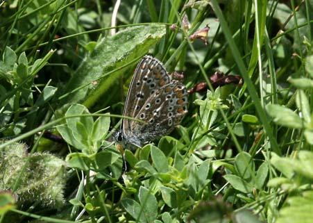
5 Adonis Blue at Mill Hill in August Adonis Blue at Mill Hill Adonis Blue (m) nectaring on carline thistle at Mill Hill in August Common Blue (f) at Mill Hill The same Common Blue (f) at Mill Hill


6 Common Blue (m) at Mill Hill View north from the Mill Hill s accessible walk LOCATION Explorer Map 122: Brighton and Hove Landranger (pink) Map 198: Brighton & Lewes Grid references: South car park TQ North car park TQ The entrances to the reserve are on a minor no-through road which runs north from Shoreham-by- Sea. If you are coming by car, leave the A27 at the A283 turning. This involves negotiating a 3- circle cloverleaf of roads. Head south towards Shoreham centre on the Steyning Road, but, after less than ½ mile, turn east on Upper Shoreham Road towards Kingston by Sea and an A&E hospital. After another ½ mile turn hard left to go north on Erringham Road, crossing the A27 on a high bridge to climb up Mill Hill. The reserve is then on your left. There are disabled spaces at the north car park. A hard-surfaced walk of about 1/3 mile begins here. It has only gentle gradients and is wide enough for wheelchairs. There are a number of other steeper paths and it is possible to make a complete circular tour of the reserve. For Chalkhill and Adonis Blues, look for sheltered areas on the lower south-west facing slopes of the hill where there are open areas of short grass between low scrubby bushes. Access by public transport is by bus to the Red Lion pub in Old Shoreham Road (Old Shoreham is just south of the A27 road interchange). From there walk north and look for the footpath that leads over the high footbridge and then forks left into the reserve. There are no toilet facilities at Mill Hill Local Nature Reserve, but the centre of Shoreham-by-Sea is not far away. Refreshments should be available at the Red Lion pub in Old Shoreham.
from the website for the book Discover Butterflies in Britain D E Newland 2009
 BEACON HILL Hampshire from www.discoverbutterflies.com the website for the book Discover Butterflies in Britain D E Newland 2009 Beacon Hill lies at the western end of the South Downs, southeast of Winchester.
Silver-washed Fritillaries in the Straits Inclosure in July
 ALICE HOLT FOREST Hampshire from www.discoverbutterflies.com the website for the book Discover Butterflies in Britain D E Newland Silver-washed Fritillaries in the Straits Inclosure in July Alice Holt
Limestone terraces (in the distance) and woodland on hills in the Upper Wharfedale valley
 and woodland on hills in the Upper Wharfedale valley") GRASSINGTON North Yorkshire from www.discoverbutterflies.com the website for the book Discover Butterflies in Britain D E Newland 2009 Limestone terraces (in the distance) and woodland on hills in the
GRASSINGTON North Yorkshire from www.discoverbutterflies.com the website for the book Discover Butterflies in Britain D E Newland 2009 Limestone terraces (in the distance) and woodland on hills in the
Lewes Downs (Mount Caburn) NNR. Welcome to the National Nature Reserve
 NNR. Welcome to the National Nature Reserve") Lewes Downs (Mount Caburn) NNR Welcome to the National Nature Reserve Welcome to Mount Caburn Lewes Downs (Mount Caburn) NNR is a chalk hill and valley with south-facing slopes, clothed in flower rich
Lewes Downs (Mount Caburn) NNR Welcome to the National Nature Reserve Welcome to Mount Caburn Lewes Downs (Mount Caburn) NNR is a chalk hill and valley with south-facing slopes, clothed in flower rich
landcapes and romance Artists and poets have been inspired by the idyllic scenes of picturesque Kent villages sheltered by rolling, chalk hills.
 landcapes and romance Artists and poets have been inspired by the idyllic scenes of picturesque Kent villages sheltered by rolling, chalk hills. WALK 4 41 41 WALK 4 42 Pond Location: Distance: 5 miles
SHEEPLEAS. Visitor Guide and Self-guided Trails
 SHEEPLEAS Visitor Guide and Self-guided Trails Sheepleas The Sheepleas is an interesting mix of woodland, scrub and open grassland, situated on the chalk of the North Downs. This diversity of habitats
Newlands Corner Leaflet 08:Newlands Corner Leaflet 5/10/09 11:58 Page 1
 Newlands Corner Leaflet 08:Newlands Corner Leaflet 5/10/09 11:58 age 1 St Martha s is the start of the Downs Link, a 33-mile long distance trail linking the North Downs Way with the South Downs Way at
Aston Rowant Discovery Trail
 The walk was developed by Aston Rowant Parish Council. The Trail is stile-free and fully way-marked. The circular route is 5.3m but with the extension to a pub and hotel 6.2m. Key Main Aston Rowant Discovery
BISHOPSTONE CIRCULAR WALK
 BISHOPSTONE CIRCULAR WALK 4½ miles (7¼ km) - allow 2 hours (see maps on final pages) Introduction This walk is within the North Wessex Downs Area of Outstanding Natural Beauty and starts from the small,
Ardingly Lake, Ouse Valley, Borde Hill
 point your feet on a new path Ardingly Lake, Ouse Valley, Borde Hill Distance: 14 km=9 miles or 12½ km=8 miles Region: West Sussex Author: Hautboy Refreshments: Borde Hill Map: Explorer 135 (Ashdown Forest)
North Meadow National Nature Reserve
 Leaflet produced with the support of Cricklade Town Council. North Meadow National Nature Reserve For further information about North Meadow contact: The Senior Reserve Manager The Ebworth Centre, The
The Chilterns Conservation Board The Lodge Station Road Chinnor Oxon OX39 4HA
 The Chilterns Conservation Board The Lodge Station Road Chinnor Oxon OX39 4HA Tel: 01844 355500 Fax: 01844 355501 E Mail: office@chilternsaonb.org www.chilternsaonb.org PRESS RELEASE Chilterns Commons
Hadleigh Castle and Chalkwell Oaze
 1 Hadleigh Castle and Chalkwell Oaze Benfleet station Hadleigh Park Hadleigh Castle Leigh-on-Sea Chalkwell station A short stroll through the lush woods of Hadleigh Park high above the Thames-side marshes,
Unimproved meadow with extensive riverside frontage and a bank of mixed hardwoods with good hard track access in the heart of rural South Wales.
 WOODS 4 SALE Phone: 01248 364 362 www.woods4sale.co.uk UK Woodland & Woods For Sale: Specialising in the Sales of Small Woodlands in England, Scotland and Wales for Recreation, Wildlife Conservation and
STORNETTA BROTHERS COASTAL RANCH
 STORNETTA BROTHERS COASTAL RANCH Location: Surrounding Point Arena Lighthouse and immediately south of Manchester State Park Mendocino Co., CA Acres: 1,860 Resources: Over two miles of Pacific Ocean coastline
West Wirral (Dee Estuary)
") View of Hilbre Island from West Kirby with walkers at low tide. West Wirral (Dee Estuary) West Kirby is the start of the 12 mile long Wirral Way, the backbone of Wirral Country Park, the old Hooton to
View of Hilbre Island from West Kirby with walkers at low tide. West Wirral (Dee Estuary) West Kirby is the start of the 12 mile long Wirral Way, the backbone of Wirral Country Park, the old Hooton to
Singleton and the South Downs
 point your feet on a new path Singleton and the South Downs Distance: 13½ km=8½ miles easy walking with a few steeper sections Region: West Sussex Author: Hautboy Refreshments: Singleton, Hill Barn Date
Baggy Point, Croyde, North Devon
 Baggy Point, Croyde, North Devon A walk using the South West Coast Path that is likely to be suitable for people with impaired mobility or with a pushchair, wheelchair, or mobility scooter. The Coast Path
White Horse. For your own safety warn the MCA Coastguard Helicopter (01305) They have been known to low fly in this area
 They have been known to low fly in this area") Site Code 2.078 OS Grid Ref: SY 715 844 (Map 194) GPS: N50:39.514 Owned and farmed by: Nearest Phone: Casualty Units: W2:24:273 P & J Critchell Farm Osmington 01305 834314 Broadmayne or Sutton Poyntz County
Site Code 2.078 OS Grid Ref: SY 715 844 (Map 194) GPS: N50:39.514 Owned and farmed by: Nearest Phone: Casualty Units: W2:24:273 P & J Critchell Farm Osmington 01305 834314 Broadmayne or Sutton Poyntz County
The following criteria were used to identify Benchmark Areas:
 7.0 BENCHMARK AREAS The Churn Creek Protected Area offers a significant opportunity to learn more about how grassland ecosystems function. One of the key tools that will be used to monitor larger grassland
Six Stage Route Guide
 NORTH DOWNS WAY Six Stage Route Guide A25 Stage 1 Stage 2 Six stage route The Downs Link follows the route of a disused railway line and is enjoyed by walkers, cyclists and horse riders. West Sussex County
This Passport: Revised October 20, 2017, EAM # Discovering the Trails of Penfield, NY
 This Passport: Revised October 20, 2017, EAM #161922 Discovering the Trails of Penfield, NY The Town of Penfield is fortunate to have a wide variety of natural resources which make for many unique and
Moorland View Princetown, Devon. 4.6 acres stand of high quality, mature conifer with good access for 28,000 (freehold)
") WOODS 4 SALE Phone: 01248 364 362 www.woods4sale.co.uk UK Woodland & Woods For Sale: Specialising in the Sales of Small Woodlands in England, Scotland and Wales for Recreation, Wildlife Conservation and
WOODS 4 SALE Phone: 01248 364 362 www.woods4sale.co.uk UK Woodland & Woods For Sale: Specialising in the Sales of Small Woodlands in England, Scotland and Wales for Recreation, Wildlife Conservation and
A Circular Walk from Chapel Carn Brea
 A Circular Walk from Chapel Carn Brea 4.3 Miles A Walk Visiting Five Historic Ancient Sites This circular walk offers the possibility of several alternatives, depending on the walker s available time and
Wicken Fen Nature Reserve Access Statement The country s oldest nature reserve,
 Wicken Fen Nature Reserve Access Statement The country s oldest nature reserve, Contact details Wicken Fen, Lode Lane, Wicken, Ely CB7 5XP T: 01353 720274 E: wickenfen@nationaltrust.org.uk Points to note
Distance: 18 km=11 miles or 12½ km=7½ miles or 9 km=5½ miles
 point your feet on a new path The Devil s Dyke Distance: 18 km=11 miles or 12½ km=7½ miles or 9 km=5½ miles Region: West Sussex Author: Hautboy Refreshments: Devil s Dyke, Fulking, Poynings moderate ing
Three mills were situated along the Loddon Valley.
 EASTROP PARK The History of Eastrop Park Eastrop dates back to Roman times, when this lush valley would have been used to grow crops, graze cattle and water horses. It was during the Saxon times, that
Drive and Stop Routes
 Drive and Stop Routes Limantour Road 1 - easy and likely productive. From Bear Valley Visitor Center drive back out and turn left onto Bear Valley Rd. Turn left at Limantour Road (the first road). Drive
IOWA ORNITHOLOGISTS' UNION - Birding Sites in Dallas County
 IOWA ORNITHOLOGISTS' UNION - Birding Sites in Dallas County Printed on 7/19/2018 Beaver Bottoms Wetland (restricted) (Important Bird Area) GPS Coordinates:, Ownership: Private (see directions for access)
Kingdom of Quarries
 For more information on our reserves, membership and to book a visit please telephone 09 84 www.durhamwt.co.uk FROM TEES TO TYNE Help conserve these internationally important sites for the future by becoming
Bewl Water & the High Weald
 1 Bewl Water & the High Weald Stonegate station - Stonegate - Wallcrouch - Newbarn - Cousley Wood - Wood's Green - Wadhurst station Length: 9 ½ miles (15.3km) Underfoot: Large portions of this path are
Lewis and Clark Recreation Area
 Lewis and Clark Recreation Area Bicycle/Pedestrian Trail Also part of the Pierson Ranch Recreation Area trail Type of trail: Walking, biking and rollerblading Trail surface: Asphalt Rated: Mostly flat.
Walking Holidays in Britain s most Beautiful Landscapes
 South Downs Way The South Downs Way starts at the ancient and historic city of Winchester and follows the northern crest of the chalk escarpment of the South Downs, all the way to the sea. Stretching for
Route #2) Mt. Massive - Southwest Slopes
 Mt. Massive - Southwest Slopes") Route #2) Mt. Massive - Southwest Slopes Difficulty: Class 2 Ski: Advanced, D6 / R2 / III Exposure: Summit Elevation: Trailhead Elevation: Elevation Gain: Round-trip Length: Trailhead: County Sheriff:
Route #2) Mt. Massive - Southwest Slopes Difficulty: Class 2 Ski: Advanced, D6 / R2 / III Exposure: Summit Elevation: Trailhead Elevation: Elevation Gain: Round-trip Length: Trailhead: County Sheriff:
HIKING IN THE CANADIAN ROCKIES
 HIKING IN THE CANADIAN ROCKIES Distance Time Elevation y MORAINE LAKE TRAILS THE ROCKPILE 0.8 km (0.5 mi) 20 min 30 m (98 ft) Located adjacent to the Lodge, the short interpretive trail up the Rock Pile
TAYLOR CANYON RANCH COLORADO - ROUTT COUNTY - STEAMBOAT SPRINGS
 TAYLOR CANYON RANCH COLORADO - ROUTT COUNTY - STEAMBOAT SPRINGS Tucked up against the steep valley shaped by Mt. Pau and rising to the Routt National Forest, Taylor Canyon Ranch is an easily accessible,
Lewes and the South Downs
 point your feet on a new path and the South Downs Distance: 0 km=1½ miles moderate walking with long easy stretches Region: East Sussex Author: Hautboy Refreshments: Date written: 8-apr-013 Map: Explorer
Kicking the Alpine Plants Out Mountain Goat Wallows In Mount Peale Research Natural Area (La Sal Mountains, Utah)
") Kicking the Alpine Plants Out Mountain Goat Wallows In Mount Peale Research Natural Area (La Sal Mountains, Utah) Marc Coles-Ritchie, Grand Canyon Trust November 21, 2017 Mountain goats are digging up
Kicking the Alpine Plants Out Mountain Goat Wallows In Mount Peale Research Natural Area (La Sal Mountains, Utah) Marc Coles-Ritchie, Grand Canyon Trust November 21, 2017 Mountain goats are digging up
Natural Heritage. Published on Turist Information of Suances (http://turismo.suances.es)
") Published on Turist Information of Suances (http://turismo.suances.es) Home > Printer-friendly PDF > Natural Heritage Natural Heritage Suances belongs to a natural region called?coast Strip? or?la Marina?.
Published on Turist Information of Suances (http://turismo.suances.es) Home > Printer-friendly PDF > Natural Heritage Natural Heritage Suances belongs to a natural region called?coast Strip? or?la Marina?.
Lent 2002 Termcard. In addition to our walks this term, we look forward to seeing you at our Formal Hall at St. John's!
 Lent 2002 Termcard Welcome back to the Rambling Club! We hope you will find time to leave the city for a few hours, and enjoy the surrounding countryside with us. The pace of our walks is generally easy,
Hillbrook Clappers Lane, Fulking, West Sussex
 Hillbrook Clappers Lane, Fulking, West Sussex Hillbrook Clappers Lane, Fulking, West Sussex BN5 9NH Offers in Excess of 795,000 Detached 3 Bedroom Bungalow Potential for Extending or Possible Rebuild,
This path goes past an old tree nursery and sawmill. After 800m it crosses over a lane. Follow the bridleway fingerpost into the woods.
 FRENSHAM PONDS 11K CIRCULAR TRAIL 2½ HRS GU10 2DA This magnificent heathland trail starts in woodland and then brings you out onto the open heather of Frensham Common, with no roadwork! The route runs
Stephens State Park Trails
 TRAILS OF ALLAMUCHY MOUNTAIN & STEPHENS STATE PARKS Allamuchy Mountain and Stephens State Parks contain 28 marked trails providing access to diverse landscapes for walking, hiking, biking, bird-watching,
Appendix 7 Local Green Spaces - Detailed Evidence
 Appendix 7 Local Green Spaces - Detailed Evidence Neigh Bridge Country Park, Somerford Keynes General information Neigh Bridge Country Park is situated at the southern entrance to Somerford Keynes village.
NOHOANGA SITE INFORMATION SHEET TUCKERS BEACH, OTAGO. Tuckers Beach Road. Entry Point to Site. Getting there
 NOHOANGA SITE INFORMATION SHEET TUCKERS BEACH, OTAGO Getting there This site is within the Tuckers Beach Wildlife Reserve, at approximately 280 Tuckers Beach Road, 15mins drive north of Queenstown township.
HARDMOORS 55 RACE ROUTE 2018 HELMSLEY - GUISBOROUGH
 HARDMOORS 55 RACE ROUTE 2018 HELMSLEY - GUISBOROUGH HELMSLEY - CHECKPOINT 1 (WHITE HORSE) 1. Leave RACE START, continue ahead on road (Baxtons Sprunt) At crossroads turn right down Canons Garth eventualy
San Luis Obispo. Bishop Peak Felsman Loop Eagle Rock Maino Open Space Poly Canyon Poly P Other Areas
 San Luis Obispo Bishop Peak Felsman Loop Eagle Rock Maino Open Space Poly Canyon Poly P Other Areas 1 JCT. ELEV. 72 400 00 0 FELSMAN LOOP GATE LOOP RIDGE 600 FENCE JCT. ELEV. 860 1000 1200 BISHOP PEAK
Beautiful Walks from the Blue Ball Inn
 Walk No. 2 WINSTONS WALK Countisbury, Wind Hill, Watersmeet, Ash Bridge and Winston s path. 5 Miles approx. Walking time- Two and a half hours approx. (Not including Breaks) OS 1:25,000 Sheet 64/74 Lynton
National Recreation Trail Application for Designation
 National Recreation Trail Application for Designation Introduction Thank you for your interest in the National Recreation Trail (NRT) program. Completed NRT application packages must be submitted by December
GREEN DIAMOND BARTHOLOMEW SQUARE, BRIGHTON
 B BARON ESTATES GREEN DIAMOND BARTHOLOMEW SQUARE, BRIGHTON 40 BRAND NEW 1 & 2 BEDROOM APARTMENTS WHAT YOU NEED TO KNOW GREEN DIAMOND BARTHOLOMEW SQUARE, BRIGHTON Green Diamond is an outstanding development
Countryside Trails Dunkeld
 R A N G E R S E RV I C E Countryside Trails Dunkeld WELCOME Welcome to this southern end of Atholl Estates. The countryside here is a wonderful blend of lochs, woodland and heather moor. There is a large
BELLHOUSE PROVINCIAL PARK
 BELLHOUSE PROVINCIAL PARK PURPOSE STATEMENT AND ZONING PLAN March 2003 1 BELLHOUSE PROVINCIAL PARK Purpose Statement and Zoning Plan Primary Role The primary role of Bellhouse Provincial Park is to protect
Delamere Loop. The. Useful Businesses Equestrian Escapes Tailor-made horse riding holidays in Cheshire. Tel:
 The Loop Accommodation Providers Akesmere Bed & Breakfast OS Grid Ref. SJ589/669 B&B for horse and rider. Chester Road, Little, Tarporley, Cheshire CW6 9ER Tel: 01829 760348 www.akesmerefarm.co.uk Useful
LFKB / Bastia-Poretta / BIA
 This page is intended to draw commercial and private pilots attention to the aeronautical context and main threats related to an aerodrome. They have been identified in a collaborative way by the main
Morning Copse near Maidstone, Kent acres of Ancient Woodland with a pond, bluebells and mature oak. 26,500 (freehold)
") WOODS 4 SALE Phone: 01248 364 362 www.woods4sale.co.uk UK Woodland & Woods For Sale: Specialising in the Sales of Small Woodlands in England, Scotland and Wales for Recreation, Wildlife Conservation and
WOODS 4 SALE Phone: 01248 364 362 www.woods4sale.co.uk UK Woodland & Woods For Sale: Specialising in the Sales of Small Woodlands in England, Scotland and Wales for Recreation, Wildlife Conservation and
Ivinghoe Beacon and the Grand Union
 1 Ivinghoe Beacon and the Grand Union Cheddington station - Horton Wharf - Ivinghoe - Ivinghoe Beacon - Bridgewater Monument - Aldbury - Tring station Length: 11 ¼ miles (18.3km) Underfoot: The first mile
You can learn more about the trail camera project and help identify animals at WildCam Gorongosa (
 INTRODUCTION Gorongosa National Park is a 1,570-square-mile protected area in Mozambique. After several decades of war devastated Gorongosa s wildlife populations, park scientists and conservation managers
National Recreation Trail Update Form
 National Recreation Trail Update Form Introduction Thank you for taking the time to complete this form. Your assistance will help ensure that the National Recreation Trail (NRT) database is complete and
Woodland Walk If you enjoyed this walk there are two others available in the same area.
 The Woodland Walk 11-12 kilometres (7-8 miles) 4-5 hours Terrain: some easy hills Can be slippery when wet 5 stiles Unsuitable for a pushchair/wheelchair Uses OS map 197 Parking: Pulborough Station and
Ainsdale Sand Dunes. National Nature Reserve
 Ainsdale Sand Dunes National Nature Reserve Welcome to Ainsdale Sand Dunes National Nature Reserve Ainsdale Sand Dunes National Nature Reserve is one of the most important wildlife sites in England. The
HIGH COUNTRY L-BAR RANCH
 HIGH COUNTRY L-BAR RANCH Sandoval and mckinley counties N e w m e x i c o Jim Haworth, Ranch Team Lead Broker ~ 505-235-5236 3613 NMSR 528 NW, Ste. H, Albuquerque, NM 87114 505-792-3713 www.wwrealty.com
Freefolk and Whitchurch
 Trail Activity Type Terrain Author Distance Ascent Location : HAMPTR0026 : Walk : Tea Shop : Towpaths and Cycle Tracks : Jean Patefield : 5.6 miles / 9 kms : 377 feet / 115 metres : SU487488 / RG28 7NN
LIFE+ URBANCOWS - Restoration of urban coastal meadow complex in Pärnu town, Estonia. Bert Holm, PhD.
 LIFE+ URBANCOWS - Restoration of urban coastal meadow complex in Pärnu town, Estonia Bert Holm, PhD. bert.holm@saaremaavald.ee Pärnu town, West-Estonia A coastal town, the population of ca 40 000 inhabitants;
PHOENIX PARK INCORPORATING THURNSCOE COMMUNITY WOODLAND
 PHOENIX PARK INCORPORATING THURNSCOE This popular site is known for its sculptures and climbing wall which can be seen as you meander around the park. Walking towards the top of the woodland you will pass
Carson City Open Space APNs and , west of Deer Run Road bridge
 32 acres (See separate packet for information on this open space property) OPEN SPACE PROPERTY APNs 008-541-73 and 008-541-92 (north and south sides of the river) Morgan Mill Road River Access Area (parking
RURAL LAND RESOURCES Case study area 1- the erosional features of the Dorset Coast.
 Case study area 1- the erosional features of the Dorset Coast. Scene setting;- This area lies on the far south coast of England, between the settlements of Lyme Regis and Bournemouth, in the county of
PASSPORT. Discovering the Trails of Webster, NY
 PASSPORT to family wellness Discovering the Trails of Webster, NY Join the Friends of Webster Trails, Webster Health and Education Network, The Town of Webster and Wegmans to get moving more and enjoy
Aira Force & Ullswater Access Statement
 Aira Force & Ullswater Access Statement Aira Force, Watermillock, Penrith, CA11 0JS T: 017684 82067 E: ullswater@nationaltrust.org.uk Section 1: Aira Force Section 2: Ullswater Countryside Section 1: Aira
Access Statement for Birling Gap
 This access statement does not contain personal opinions as to our suitability for those with access needs, but aims to accurately describe the facilities and services that we offer all our guests/visitors.
North Pennine Birdwalks. Walk 11: Dufton Pike
 North Pennine Birdwalks Walk 11: Dufton Pike The Birdwatchers Code of Conduct Birds are very vulnerable to disturbance, especially during the breeding season. It is all too easy to inadvertently harm a
Walk 1. Cotswold Water Park. Gateway Centre to Cerney Wick, railway track to Lake 6, Gateway Centre.
 Cotswold Water ark Walk way A Swindon/ Cirencester Thomas and Severn Canal way to Cerney Wick, railway track to Lake, way. Spine Road East Hotel Time: hours (short walk km) Distance: km A level walk along
Eastbourne. Alfriston 3¾ 6 3¾ 6. Birling Gap. Exceat
 3.8a Alfriston to Eastbourne (footpath) Map panel 6 (page 64) Distance 10½ miles (17 km) Terrain valley walk initially, first along riverbank path then hillside paths above, including stretch through forest;
Outdoor Developed Areas
 The United States Access Board is an independent federal agency that promotes equality for people with disabilities through leadership in accessible design and the development of accessibility guidelines
What s covered. What s not covered. Options for those not covered. ABA Coverage
 The United States Access Board is an independent federal agency that promotes equality for people with disabilities through leadership in accessible design and the development of accessibility guidelines
Self-Guided Walk Malham, Gordale and Malham Tarn
 Self-Guided Walk Malham, Gordale and Malham Tarn Combine all the major geological attractions of Malham in this walk and hopefully leave enough time to enjoy the cafes, pubs and shops of the village. Malham
INTRODUCTION BOWLAND FOREST GLIDING CLUB
 INTRODUCTION TO BOWLAND FOREST GLIDING CLUB Welcome to Bowland Forest Gliding Club Thank you for wanting to know about gliding at Bowland Forest. Visitors are always welcome. You can come to watch the
1. INTRODUCTION 2. CURRENT STATUS
 LOWLAND HEATHLAND AND LOWLAND DRY ACID GRASSLAND IN OXFORDSHIRE UK Biodiversity Group - Priority Species associated with heathland Nightjar Linnet Dingy mocha moth Grey scalloped bar moth, Other Associated
Queen Elizabeth II Diamond Jubilee Herne Bay Coastal Park Action Plan. Kings Hill slopes, Beacon Hill, The Downs, Bishopstone Glen and Reculver
 Appendix 3 Queen Elizabeth II Diamond Jubilee Coastal Park Action Plan Kings Hill slopes, Beacon Hill, The, Bishopstone Glen and Reculver This area moves from the commercial centre of the Coastal Park
Discovery Trail. outstanding natural beauty.
 Discovery Trail Discover the Tamar Valley Area of Outstanding Natural Beauty along this 30-mile walking route. Waymarkers guide you through scenic woodland, historic river quays and rural villages. outstanding
COME & enjoy THE. Trans Pennine Trail. Penistone-Dunford Bridge. Trans Pennine Trail conservation volunteers Penistone Dunford Bridge
 COME & enjoy THE Penistone-Dunford conservation volunteers Penistone Dunford Welcome to your! Running between the lively market town of Penistone, and the lower slopes of the Peak District at Dunford,
Port Gamble Shoreline Area Conceptual Trail Proposal
 The North Kitsap Trails Association is pleased to be a partner to the Kitsap Forest and Bay Project and assist Kitsap County, Forterra, Olympic Property Group, Great Peninsula Conservancy and the Port
Cemetery Price List Effective January 15, 2018
 Cemetery Price List Effective January 15, 2018 NATURAL BURIAL OPTIONS Lower Meadow The Restoration of Fernwood s Coastal Prairie. Habitat Interpretation: High density of wild flowers provides a seed bank
Broomhill Park - 10 Year Vision Document
 Broomhill Park will provide a vibrant community focal point functioning as a green oasis within Strood, emphasizing the views of the surrounding countryside and giving consideration to biodiversity within
Pontfadog. Walk A. Walk A
 Walk A A Bird s eye view of the village 2km. (1 1 /2 miles); height gain 45m. (150ft) about 45 minutes. Six minutes walk along the main road towards Glyn Ceiriog reach a signpost to Llwynmawr. Take the
Skipton Castle Woods Accessibility Statement November 2016
 Skipton Castle Woods Accessibility Statement November 2016 Purpose: This accessibility statement outlines the available facilities and access information for Skipton Castle Woods. Welcome We, the Woodland
Rough Haugh Wood Midmar, near Torphins, Aberdeenshire wild acres of undisturbed woodland habitat for 21,000 (freehold) [#A895]
![Rough Haugh Wood Midmar, near Torphins, Aberdeenshire wild acres of undisturbed woodland habitat for 21,000 (freehold) [#A895]](/thumbs/86/93824356.jpg "Rough Haugh Wood Midmar, near Torphins, Aberdeenshire wild acres of undisturbed woodland habitat for 21,000 (freehold) [#A895]") WOODS 4 SALE Phone: 01248 364 362 www.woods4sale.co.uk UK Woodland & Woods For Sale: Specialising in the Sales of Small Woodlands in England, Scotland and Wales for Recreation, Wildlife Conservation and
WOODS 4 SALE Phone: 01248 364 362 www.woods4sale.co.uk UK Woodland & Woods For Sale: Specialising in the Sales of Small Woodlands in England, Scotland and Wales for Recreation, Wildlife Conservation and
Barra Wood, Perthshire - Just over 11 acres, 69,000
 Barra Wood, Perthshire - Just over 11 acres, 69,000 Barra Wood is a truly spectacular woodland that would make a perfect retreat from the stresses of modern day life. Close to the entance of the wood and
START - UPHILL BEACH. (tidal!) The West Mendip Way is route-marked with these round blue signs
 The West Mendip Way is route-marked with these round blue signs") START - UPHILL BEACH Start Times: 10:30 11:15 12:00 Please allow sufficient time to check in with the marshals Start on the beach at the high water line (tidal!) The West Mendip Way is route-marked with
START - UPHILL BEACH Start Times: 10:30 11:15 12:00 Please allow sufficient time to check in with the marshals Start on the beach at the high water line (tidal!) The West Mendip Way is route-marked with
BUCK POINT RANCH. Aspen Associates Realty
 BUCK POINT RANCH Aspen Associates Realty www.aspenassociatesrealty.com 970.544.5800 WELCOME TO Buck Point Ranch is a 960± acre property located in one of the last pristine valleys in close proximity to
Recreational Carrying Capacity
 9 th Annual Caribbean Sustainable Tourism Conference Recreational Carrying Capacity Graham C Barrow What is Recreational Carrying Capacity? It s not about fixing absolute numbers of visitors/tourists that
Lodsbridge Mill, Selham, West Sussex
 Lodsbridge Mill, Selham, West Sussex A small estate with an 18th Century former watermill on the banks of the River Rother, separate 17th Century cottage, spa complex and stabling, total 18.73 acres (7.58
Self-Guided Walk Langdale Pikes. Start & Finish: NT car park (free to members) at Sticklebarn - on the right just beyond the New Dungeon Ghyll hotel.
 at Sticklebarn - on the right just beyond the New Dungeon Ghyll hotel.") Self-Guided Walk Langdale Pikes Key Information These mountains form a collection of spires and cliffs on the north side of Langdale. This walk visits four of the main tops Pavey Ark, Harrison Stickle,
Self-Guided Walk Langdale Pikes Key Information These mountains form a collection of spires and cliffs on the north side of Langdale. This walk visits four of the main tops Pavey Ark, Harrison Stickle,
A leisurely one mile stroll through the history of Aldershot s Manor park, considered by many as the most attractive and pleasant parts of our town.
 Figure 1 Entrance to Park from the Aldershot Green/Churchill road end A leisurely one mile stroll through the history of Aldershot s Manor park, considered by many as the most attractive and pleasant parts
SOUTH DOWNS WAY THE SOUTH DOWNS WAY - SELF GUIDED WALKING HOLIDAY CHALK CLIFFS OF THE SOUTH COAST SUMMARY HIGHLIGHTS
 THE SOUTH DOWNS WAY - SELF GUIDED WALKING HOLIDAY The South Downs Way stretches 00 miles from the historic city of Winchester to the coastal chalk hills on the South Coast. Located within an hour from
Tees Railway Path. What is special?
 What is special? The Tees Valley Railway was the remnant of a scheme for a le from Barnard Castle to Alston. It was opened 1868 by an dependent company and was taken over by the orth East Railway 1882.
Ystwyth and Rheidol Bridleway Routes. Route 2:Llanilar Circular
 Ystwyth and Rheidol Bridleway Routes Route 2:Llanilar Circular Route overview and terrain: A long circle using connecting ridges with fine views to link the Rheidol and Ystwyth river valleys. The route
Appendix 8 Sawston Greenway Review
 Appendix 8 Sawston Greenway Review Nigel Brigham & Associates A report for 1 Introduction This report is based on fieldwork carried out in 2016 to review the Greenway network around Cambridge as shown
Customer Information. Technical Information
 LEGEND OS EXPLORER 1: 25 000 scale Customer Information Crown copyright 2017. All rights reserved. Version 2017-01 Whilst we have endeavoured to ensure that the information in this product is accurate,
Access Statement for Ynys-hir RSPB Reserve
 This access statement does not contain personal opinions as to our suitability for those with access needs, but aims to accurately describe the facilities and services that we offer all our guests/visitors.
A FIELDWALKING PROJECT AT HOLLINGBURY, BRIGHTON. by JOHN FUNNELL
 Introduction A FIELDWALKING PROJECT AT HOLLINGBURY, BRIGHTON by JOHN FUNNELL Members of the Brighton and Hove Archaeological Society walked the field at Hollingbury during the months of December 1991 and