WALKS AROUND WOODHURST
|
|
|
- Roy Ferguson
- 5 years ago
- Views:
Transcription

1 WALKS AROUND WOODHURST With Walks To Woodhurst from North St. Ives Woodhurst is situated on the verge of an elevated tract of table land four miles north of St. Ives. Its footpaths vary from leafy lanes to broad vistas over the Ouse Valley. This Leaflet is published by Woodhurst Parish Council supported by the Parish Paths Partnership Scheme.
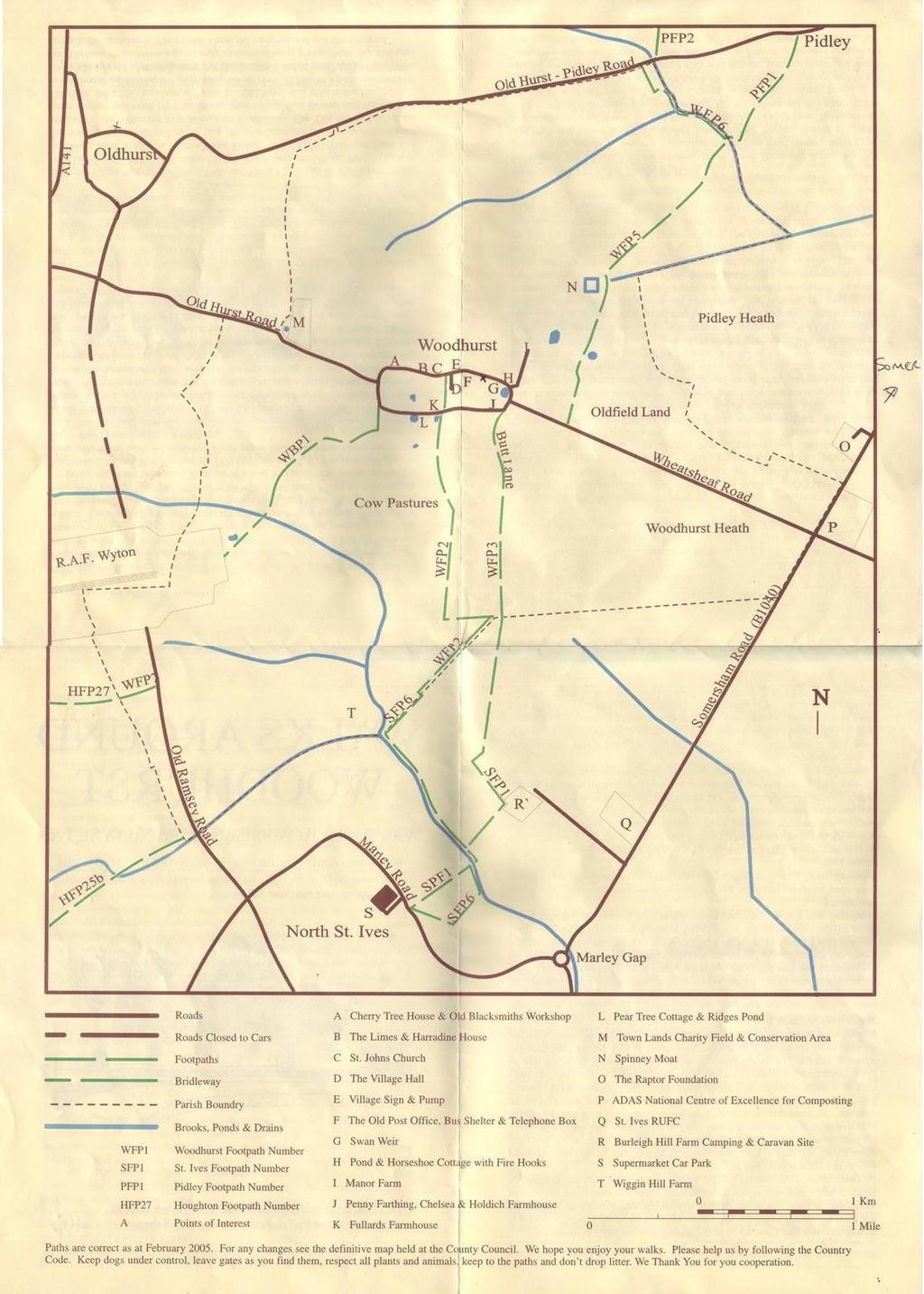
2 Walk round the village of Woodhurst The village of Woodhurst was until the 1920s, houses and farms, a shop, a church, a blacksmith and a few pubs built around a road shaped like a squashed ring. Since then five roads with houses on them have been built into the ring. Luckily there has been no road across the ring, or any ribbon development on the roads leading to the village. It is interesting to walk round the village (just about a mile). If you start at West End where the road from the A141 meets the village there are five houses and bungalows facing. The three houses were built in the early l820s on land outside the boundary of the meadow. Take the left road and round the corner on the left hand side is Cherry Tree House.(A) This building is at least 200 years old and for some time in the middle 1800s was a beer house called The Sun, next but one to this is the old blacksmith s workshop. Walk down the road until you reach The Limes on your left. (B) This house, set back a little from the road, was built in 1843 on land given by Sir John Pelly, Lord of the Manor, to be a school for the education of poor children of Woodhurst and Old Hurst. When the school closed in the 1 880s it became a house for the curate from St Ives who looked after the churches of the two villages. It is now a private house. Opposite The Limes is a new close of houses called Harradine Close. An archaeological survey, carried out before the houses were built, found a number of skeletons including one near the road, aligned north/south with the skull buried near the feet. Pottery was also found dating from Roman times. Harradine Farm Cottage and Harradine House are adjacent to Harradine Close. The Cottage was for many years a farmhouse, Harradine House was a public house called the Half Moon and Stars. The Church of St John the Baptist is on the other side of the road. (C) The oldest part of the church dates from the 12th century. It has an interesting pepper-pot bell tower but unfortunately only one bell remains, dating from Opposite is Church View, at one time a pub called The Farmer s Boy and the next house, St John s House built in the 1860s was built as a pub called The Traveller s Arms. Church Lane, which connects Church Street to South Street is adjacent to St John s House. St John s Close was built in the 1970s; the Village Hall can be found just on the right in this close.(d) Walk down Church Street, past the Village Pump, (E) now no longer used, until you reach Chapel House on the right. This was built as a Baptist Chapel and School in the mid 19c and remained the Village School until 1963.(F) The following three houses are interesting. The Old Post Office as the name implies was until 1998 the village Post Office. Erin House, next door has an 18c front and a 19c extension at the back. Old Farm was built in the 19c and next to this house are two barn Conversions. Swan Weir, (G) the last house on this side of the road is the oldest house in the village and is dated from the late 16c. The pond in front of the house was not only a source of water for the fields, but also used to wash the cartwheels. The places where the carts entered and left the pond can still be seen. Opposite the pond is Horseshoe Cottage (H) Built in the early 17c this was for many years the Three Horseshoes public house. In the 19 and 20c the Manor Court met there. In 1920s it became a private house. Fire hooks to pull burning thatch from roofs are fixed to the front of the house. To the right of Horseshoe Cottage is the drive leading to the Manor Farmhouse. (I) This is an imposing building, parts of which date to the early 17c although it is mainly from the early 18c. Continuing around the ring past the pond with Wheatsheaf Road, which leads to the B1040, on the left (this road is relatively new, only about 200 years old) you come to Butt Lane (start of FP3) and the beginning of South Street. This is also known as Back Street. As you walk along this street on your left, past the new thatched cottage called Moat Cottage you come to Penny Farthing and Chelsea (J). This row of what is now two cottages were built in the early 18e. Opposite are Holdich Farmhouse and Holdich
3 Cottage. Originally this was one dwelling. Built in the early 18th century it is named after Thomas Holdich who died in A short distance along South Street is a row of three brick cottages (originally five). When they were being renovated evidence was found of the disastrous fire that swept through the village in This was the first of four fires that occurred throughout the 19c. Passing Burleigh Lodge, a listed mid 19e house on the right and a modern close of houses you come to Fullards Farmhouse. (K) The Fullards or Fuller family were prominent in the village from the beginning of the 18c to the first part of the 19c. Parts of this house date to this period. Footpath 2, which leads to St Ives, starts in the field opposite this farmhouse. The Willows the next to last house on the left hand side of South Street was built probably about A small Particular Baptist Chapel built in 1904, demolished in 2005, was between the bungalow and The Willows. This replaced a thatched chapel built in The final house on this street is Pear Tree Cottage. (L) The deeds for this cottage go back to the mid 18c. Woodhurst has many natural ponds and Ridges Pond is near this cottage on the south side of South Street. Have a rest by this pond on the seat provided by the Parish Council. Then continue to the western corner of South Street and the start of Woodhurst BR 1. WOODHURST FOOT & BRIDLEPATHS Bridlepath No 1 leads from the western end of South Street and is the only bridlepath in the parish. It goes in a southerly direction for a short distance before you turn right and follow it to the boundary fence of RAF Wyton. Before 1952 this joined up with what is now the Old Ramsey Road and led to St Ives. However the RAF extended their runway to accommodate the V-bombers and this route to the nearest market town was cut. Look out for muntjak deer when walking here. Footpath No.2 The first section of this path has recently been re-aligned to its original position and the edges planted with wild flowers, hedging plants and trees. Notice the ridge and furrow on either side, made as a result of the strip method of farming used hundreds of years ago. Go through the kissing gate and across the big field through a hedge and turn left to the spinney. You now have a choice; either go through the spinney back to the village or turn right and follow the field edge to a small bridge. This is where you leave the Parish of Woodhurst and follow FP 6. If you follow this path you will come to Marley Road opposite the Rainbow Superstore; or you can go to the junction with St Ives FP 1 and turn north to walk back to Woodhurst. Footpath No. 3 This travels south from the eastern end of South Street and is known as Butt Lane. Formerly the old drovers road to St Ives, this was at one time largely clear of any undergrowth. The hedges and ditches are now full with many elm, hawthorn and blackthorn. About 300 metres along the lane on the right there used to be allotments, originally given to soldiers returning from the First World War. Walk on through the spinney, you can then go right along FP2A and then right on FP2 back to the village, or carry straight on over the St Ives Parish boundary to St Ives FP 1. Footpath No.4 Known as Church Lane this links Church Street with South Street. Once open for ponies and traps, but now barriers either end restrict this tarmac lane to walkers. Footpaths Nos. 5 & 6 This path leaves Wheatsheaf Road about 300 metres east of the village, and goes north towards Pidley along the field edges. After 700 metres you will pass Spinney Moat on the left, the origins of which are a mystery. If it is a clear day look right and you should see Ely Cathedral. Turn left at the Brook on to FP 6 and it will take you to the Old Hurst-Pidley road. If you turn right and cross the brook you enter Pidley parish. Follow this path and you come to the Mad Cat public house. Walks from North St Ives As parking in Woodhurst is difficult an interesting way to visit the parish is via two circular walks of approx 4 or 8 kms, from north St Ives having parked in the Rainbow car park. Turn right from the car park along Marley Rd to the start of SFP6, continue to the brook, cross, turn left beside the brook to where the path
4 turns right by a ditch. Continue to a bridge cross onto WFP2; continue to the spinney; here you have the choice to carry on with the 8km walk or return to St Ives on the 4km one. To return, turn right through the spinney then right over bridge to SFP1. Pass through a small wildlife area then along by a hedge and embankment to where the path turns left through a newly planted wood. On leaving the wood turn right down Burley Hill back to the brook. This is an ancient path; in the Pettis survey of St Ives in 1728 it is described as the road to Wood Hurst. To continue on to Woodhurst village, turn left when you reach the spinney, on beside a hedge, turn right across an arable field. Here you have excellent views of Woodhurst, to front, and Wyton Airfield to your left. Pass through the kissing gate and on to the village where you can follow the walk round the village. To return to St Ives go down Butt Lane WFP3 to the spinney then via SFP1 as 4km walk.
5
BURGHCLERE PARISH RIGHTS OF WAY
 BURGHCLERE PARISH RIGHTS OF WAY Full descriptions compiled by Neill & Miggie Bruce All photos Miggie Bruce FP23 on Ridgemoor, looking south, with FP22 crossing by the bush FP1. From C183 Aldern Bridge
Woodland Walk If you enjoyed this walk there are two others available in the same area.
 The Woodland Walk 11-12 kilometres (7-8 miles) 4-5 hours Terrain: some easy hills Can be slippery when wet 5 stiles Unsuitable for a pushchair/wheelchair Uses OS map 197 Parking: Pulborough Station and
Hay Wood, Rowington and Baddesley Clinton - Warwickshire
 Hay Wood, Rowington and Baddesley Clinton - Warwickshire Starts at Lay-by alongside Hay Wood 2 hours 30 minutes 5.5miles 8.8km Leisurely ID: 0.683 Developed by: John Clift Checked by: Andy Page www.ramblersroutes.org
Aston Rowant Discovery Trail
 The walk was developed by Aston Rowant Parish Council. The Trail is stile-free and fully way-marked. The circular route is 5.3m but with the extension to a pub and hotel 6.2m. Key Main Aston Rowant Discovery
Walk 1: Highfield, Lob Wood and The River Wharfe
 Walk 1: Highfield, Lob Wood and The River Wharfe Start: The Hen Pen Garden, Main Street, Addingham LS29 0NS, SE 077 498. Alternative Start: Near Bolton Bridge SE 071 525 (see page 6). Full walk: 4.5 miles
Pontfadog. Walk A. Walk A
 Walk A A Bird s eye view of the village 2km. (1 1 /2 miles); height gain 45m. (150ft) about 45 minutes. Six minutes walk along the main road towards Glyn Ceiriog reach a signpost to Llwynmawr. Take the
The. History Walk. WWII Armaments factory
 The History Walk WWII Armaments factory 4.8-6.5 kilometres (3-4 miles) 2.5-3.5 hours Terrain: easy Can be slippery when wet No stiles Unsuitable for a pushchair/wheelchair Uses OS map 197 Parking: Pulborough
COSTOCK. Location and boundaries. is bounded to the north by Bunny, to the east by Wysall, to the south by Rempstone and to the west
 VCH Nottinghamshire On-line Texts in Progress This version: January 2013 Author: Sheila Leeds COSTOCK Location and boundaries The ancient parish of Costock occupies 1,688 acres 1 about 9½ miles south of
The Buildings of Ailsworth
 Chapter 10 The Buildings of Ailsworth Introduction Today, old and new houses, large and small, stand side by side, the result of the natural growth of the village of Ailsworth. It is now difficult to imagine
The Castor Roman Walk
 The Castor Roman Walk Welcome to the Route Plan and teachers notes for the Castor Roman Walk. The walk is approximately 3km, with an optional extension of 0.7km. We suggest that you bring with you OS Explorer
Leaden Boot Challenge ROUTE INSTRUCTIONS
 Leaden Boot Challenge ROUTE INSTRUCTIONS Section 1 Alstonefield to Ilam From the village hall car park turn R then L and pass through the village keeping to the R to enter Church Street. Pass the Church
A leisurely one mile stroll through the history of Aldershot s Manor park, considered by many as the most attractive and pleasant parts of our town.
 Figure 1 Entrance to Park from the Aldershot Green/Churchill road end A leisurely one mile stroll through the history of Aldershot s Manor park, considered by many as the most attractive and pleasant parts
The Mendip Way. Route Directions and Maps Uphill to Wells
 The Mendip Way Route Directions and Maps Uphill to Wells Website: www.mendiphillsaonb.org.uk Email: mendip@mendiphillsaonb.org.uk Facebook & Twitter: @MendipHillsAONB Phone: 01761462338 1 Uphill to Loxton
3.1 Bowness-on-Solway to Carlisle
 3.1 Bowness-on-Solway to Carlisle Map panel 1 Distance 15 miles (24 km) Terrain minor roads, tracks, field paths and riverside footpath, muddy in places Grade easy, with gentle gradients on undulating
START - UPHILL BEACH. (tidal!) The West Mendip Way is route-marked with these round blue signs
 The West Mendip Way is route-marked with these round blue signs") START - UPHILL BEACH Start Times: 10:30 11:15 12:00 Please allow sufficient time to check in with the marshals Start on the beach at the high water line (tidal!) The West Mendip Way is route-marked with
START - UPHILL BEACH Start Times: 10:30 11:15 12:00 Please allow sufficient time to check in with the marshals Start on the beach at the high water line (tidal!) The West Mendip Way is route-marked with
The History of a Floodplain Meadow Bridget Smith
 The History of a Floodplain Meadow Bridget Smith I have lived in the village of Hemingford Grey near the River Great Ouse since 1976 and, like many others, walked the 1½ km into St Ives by the ancient
Walk 1. Cotswold Water Park. Gateway Centre to Cerney Wick, railway track to Lake 6, Gateway Centre.
 Cotswold Water ark Walk way A Swindon/ Cirencester Thomas and Severn Canal way to Cerney Wick, railway track to Lake, way. Spine Road East Hotel Time: hours (short walk km) Distance: km A level walk along
Centurion Way Chichester
 Centurion Way Chichester Work book of plans to show details of the Centurion Way, its links, and potential developments and enhancements from linking to the South Downs National Park all the way to the
Ardingly Lake, Ouse Valley, Borde Hill
 point your feet on a new path Ardingly Lake, Ouse Valley, Borde Hill Distance: 14 km=9 miles or 12½ km=8 miles Region: West Sussex Author: Hautboy Refreshments: Borde Hill Map: Explorer 135 (Ashdown Forest)
The future route of the road passes across the following pieces of land: Field number Landowner Occupier Lands+premises. John Chatfield Mott
 Some King s Heath street name origins. Valentine Road by Andy Bishop The first place to start when looking at the history of places in Kings Heath is to look for any clues on the 1838 Tithe Map of the
The Copper Horse Lodge, Windsor Park George III statue and view of Windsor Castle Andy Oakes Julian P Guffogg Don Cload
 Trail Activity Area Type(s) Author Distance Ascent Location : BRKSTR0008 : Walk : Windsor and the South East : Country Escape : Andy Oakes : 5 miles / 8.1 km : 239 feet / 73 metres : SU947727 / SL4 2BT
SURVEY OF PUBLIC HOUSES WESTON TURVILLE
 BUCKINGHAMSHIRE ARCHAEOLOGICAL SOCIETY HISTORIC BUILDINGS GROUP SURVEY OF PUBLIC HOUSES IN THE PARISH OF WESTON TURVILLE BUCKINGHAMSHIRE A record of extant buildings that are currently or were formerly
Gomshall station - Abinger Hammer - Abinger Common - Friday Street - Leith Hill - Coldharbour - Holmwood station
 1 To Leith Hill Gomshall station - Abinger Hammer - Abinger Common - Friday Street - Leith Hill - Coldharbour - Holmwood station Important note: this walk cannot currently be done wholly by train on a
Leaden Boot Challenge 2016 ROUTE INSTRUCTIONS
 Leaden Boot Challenge 2016 ROUTE INSTRUCTIONS Section 1 Alstonefield to Ilam (CP2) From the village hall car park turn R then L and pass through the village keeping to the R to enter Church Street. Pass
Aeron & Arth walks 4 walks for all the family to enjoy
 Aeron & Arth walks walks for all the family to enjoy Please take note that the maps illustrating these walks are intended as a rough guide only. You should use the most recent version of the relevant Ordnance
Singleton and the South Downs
 point your feet on a new path Singleton and the South Downs Distance: 13½ km=8½ miles easy walking with a few steeper sections Region: West Sussex Author: Hautboy Refreshments: Singleton, Hill Barn Date
Beautiful Walks from the Blue Ball Inn
 Walk No. 5 RIVER VALLEYS AND MOOR Countisbury, Watersmeet, Hillsford Bridge, Cheriton, Shilstone Hill, Rockford and Chiselcombe. 8.5 MILES APPROX. Walking time four and a half hours approx. OS 1;25,000
The 34 th Poppyline Marathon
 The 34 th Poppyline Marathon Saturday 9th June 2018 - Route Description Emergency number: 07906 404673 or 07597 052572 Ahd - Ahead BL - bear left BR - bear right BW - bridleway Cont - continue FB - footbridge
Gomshall station - Abinger Hammer - Abinger Common - Friday Street - Leith Hill - Coldharbour - Holmwood station
 1 To Leith Hill Gomshall station - Abinger Hammer - Abinger Common - Friday Street - Leith Hill - Coldharbour - Holmwood station Important note: this walk cannot currently be done on a Sunday due to the
Beamers Trail. Walk No.1. 6 miles. (easy with some moderate ascents and descents)
") Beamers Trail Walk No.1 6 miles (easy with some moderate ascents and descents) 1 BEAMERS TRAIL 6 miles (easy with som WALK The Warpers Trail forms part of the long distance Witton Weavers Way. This is
Beamers Trail Walk No.1 6 miles (easy with some moderate ascents and descents) 1 BEAMERS TRAIL 6 miles (easy with som WALK The Warpers Trail forms part of the long distance Witton Weavers Way. This is
i. General Data Protection Regulation Nothing new to report, keep on agenda until update from SPCA
 ABBOTS BROMLEY PARISH COUNCIL Minutes of the Parish Council Meeting Held on Wednesday, 25 th April 2018 at 7.00 pm At the Village Hall, Abbots Bromley, pursuant to notice having been given 25 th April
Invitation to tender for: Grass cutting contract for South Marston Parish Council (April 2018 March 2019)
") Invitation to tender for: Grass cutting contract for South Parish Council (April 2018 March 2019) South Parish Council invites offers for the supply of grass cutting services within the parish of South.
Invitation to tender for: Grass cutting contract for South Parish Council (April 2018 March 2019) South Parish Council invites offers for the supply of grass cutting services within the parish of South.
Appendix 9 Melbourn Greenway Review
 Appendix 9 Melbourn Greenway Review Nigel Brigham & Associates A report for 1 Introduction This report is based on fieldwork carried out in 2016 to review the Greenway network around Cambridge as shown
U3A WALK Harby Hose. Route Summary. Route Overview. Description. Waypoints. Harby. Stuart Galloway
 U3A WALK Harby Hose Stuart Galloway Route Summary A circular walk taking in Harby, Hose and the Grantham Canal. Route Overview Category: Walking Length: 7.310 km / 4.57 mi Parking: Village Hall School
BISHOPSTONE CIRCULAR WALK
 BISHOPSTONE CIRCULAR WALK 4½ miles (7¼ km) - allow 2 hours (see maps on final pages) Introduction This walk is within the North Wessex Downs Area of Outstanding Natural Beauty and starts from the small,
Minutes of Parson Drove Parish Council Meeting held in The Cage on Wednesday 10 th August 2016.
 1228 Minutes of Parson Drove Parish Council Meeting held in The Cage on Wednesday 10 th August 2016. Attended by Councillors G Booth (Chairman), P Spriggs (Vice Chairman), C Bates, J Cook, J Hunt, & P
3. The Built Heritage
 3. The Built Heritage Archaeology There are individual and clusters of bronze/iron age barrows on the surrounding Wolds within the parish. The West of the Parish contains the line of the Roman Road to
Updated April Ref No. Deeds at Lloyds TSB, Sydney Street, Cambridge Deeds at Lloyds TSB, Sydney Street, Cambridge
 Updated April 2018 Ref No Description of FIXED Replacement ASSET Identification Date of Acq Purchase Cost Market Value Insurance Value Custodian/Tenant Notes/Disposal/Discharge Maintenance OO1 Moated Denny
Following the Worcester & Birmingham Canal Feeder in Kings Norton Visiting Lifford Reservoir & Wychall Reservoir. Lifford
 Worcester-Birmingham & Droitwich Canals Society SUMMER WALK Following the Worcester & Birmingham Canal Feeder in Kings Norton Visiting Lifford Reservoir & Wychall Reservoir Lifford Reservoir Wychall Reservoir
Ystwyth and Rheidol Bridleway Routes. Route 2:Llanilar Circular
 Ystwyth and Rheidol Bridleway Routes Route 2:Llanilar Circular Route overview and terrain: A long circle using connecting ridges with fine views to link the Rheidol and Ystwyth river valleys. The route
Reigate Hill and Gatton Park
 point your feet on a new path Reigate Hill and Gatton Park Distance: 11½ km=7 miles easy-to-moderate walking or 2 walks of 6½ km=4 miles and 5½ km=3½ miles Region: Surrey Author: Schwebefuss Refreshments:
HILGAY PARISH COUNCIL
 HILGAY PARISH COUNCIL Draft minutes of the Parish Council meeting held on Thursday 5 th March 2015 7.00pm in Hilgay village hall. Before the Parish Council meeting commenced Dr. Clive Bond, Chairman of
Regular Inspections/Contract - Yes Yes Yes Yes Yes Trees/Hedges/Grass Cutting. Risk Assessment Yes Yes Yes Yes Yes
 ENVIRONMENTAL MANAGEMENT FIVE YEAR PLAN RECREATION GROUNDS BALL FIELD, CRANBROOK - T.M.P.F.T. YEAR 1-2018/2019 YEAR 2-2019/2020 YEAR 3-2020/2021 YEAR 4-2021/2022 YEAR 5-2022/2023 Regular Inspections/Contract
GOLDSWORTH PARK A SELF-GUIDED HERITAGE WALK
 GOLDSWORTH PARK A SELF-GUIDED HERITAGE WALK WITH NOTES AND ILLUSTRATIONS ON THE HISTORY OF THE AREA Based on the Heritage Walk on Sunday 15th January, 2012 By Iain Wakeford www.heritagewalks.org A HERITAGE
Morning Copse near Maidstone, Kent acres of Ancient Woodland with a pond, bluebells and mature oak. 26,500 (freehold)
") WOODS 4 SALE Phone: 01248 364 362 www.woods4sale.co.uk UK Woodland & Woods For Sale: Specialising in the Sales of Small Woodlands in England, Scotland and Wales for Recreation, Wildlife Conservation and
WOODS 4 SALE Phone: 01248 364 362 www.woods4sale.co.uk UK Woodland & Woods For Sale: Specialising in the Sales of Small Woodlands in England, Scotland and Wales for Recreation, Wildlife Conservation and
Horden. A walk of nature...sea and history
 Horden A walk of nature......sea and history 182 283 A181 Wingate B1287 Peterlee Seaham Easington B1281 Newcastle Horden Blackhall A179 Newcastle International Airport Crimdon A1086 Location... Horden
Updated May 2017 Description of FIXED ASSET Identification Date of Acq Purchase Cost Market Value
 Ref No Updated May 2017 Description of FIXED ASSET Identification Date of Acq Purchase Cost Market Value OO1 Moated Denny Station Road B1102 1911 OO2 Denny Recreation Green (approx 3 acres) Station Road
Silver-washed Fritillaries in the Straits Inclosure in July
 ALICE HOLT FOREST Hampshire from www.discoverbutterflies.com the website for the book Discover Butterflies in Britain D E Newland Silver-washed Fritillaries in the Straits Inclosure in July Alice Holt
Baslow & Bubnell Page 1 of 5 A Comparison
 Baslow & Bubnell Page 1 of 5 Introduction This paper describes the number of houses in Baslow and Bubnell from 1670 up to the present day. Most of the data was obtained by counting the buildings on a series
A Circular Walk from Chapel Carn Brea
 A Circular Walk from Chapel Carn Brea 4.3 Miles A Walk Visiting Five Historic Ancient Sites This circular walk offers the possibility of several alternatives, depending on the walker s available time and
Bewl Water & the High Weald
 1 Bewl Water & the High Weald Stonegate station - Stonegate - Wallcrouch - Newbarn - Cousley Wood - Wood's Green - Wadhurst station Length: 9 ½ miles (15.3km) Underfoot: Large portions of this path are
The Hundred Parishes
 The Hundred Parishes Walks from railway stations number 3 3 miles (5kms) circular walk from Stansted Mountfitchet Start & finish: Stansted Mountfitchet station. Ordnance Survey Explorer Map 195. Grid Reference:
Date Rec d TL PC PC 21/9/18 27/9/18 DH DB JD JB 21/9/18 26/9/18 DH DB JD JB. 20/9/18 25/9/18 PC Object with Reasons
 The is the view of the Parish Council and will be considered, along other consultations, by Wiltshire Council, who will make the decision. : to by of 18/09042/FUL Proposed single storey front extension.
Morgan s Vale and Woodfalls History Trail. (You could start at any point and follow the trail round)
") Morgan s Vale and Woodfalls History Trail (You could start at any point and follow the trail round) 1) MORGAN S VALE & WOODFALLS PRIMARY SCHOOL Built in 1869, it served as a church on Sundays until the
Morgan s Vale and Woodfalls History Trail (You could start at any point and follow the trail round) 1) MORGAN S VALE & WOODFALLS PRIMARY SCHOOL Built in 1869, it served as a church on Sundays until the
St Breward Parish Council
 St Breward Parish Council Footpath Paring Schedule for 2017 Tenders are invited for the maintenance of the Public Footpaths in St Breward Parish from suitably qualified contractors. Persons wishing to
Chess & Gade. Chalfont & Latimer Station - Latimer - Chenies - Sarratt - Kings Langley Station. Length: 8 ¾ miles (14.25km)
") 1 Chess & Gade Chalfont & Latimer Station - Latimer - Chenies - Sarratt - Kings Langley Station Length: 8 ¾ miles (14.25km) Underfoot: Well-trodden paths, mainly firm in all weather conditions, though
1 Chess & Gade Chalfont & Latimer Station - Latimer - Chenies - Sarratt - Kings Langley Station Length: 8 ¾ miles (14.25km) Underfoot: Well-trodden paths, mainly firm in all weather conditions, though
Basingstoke Canal and Dogmersfield
 point your feet on a new path? Basingstoke Canal and Dogmersfield Distance: 11 km=7 miles easy ing or 2 s of 7½ km=4¾ miles and 5¼ km=3¼ miles Region: Hampshire Author: Botafuego Refreshments: The Barley
Penn Common and Bramshaw Wood
 Trail Activity Type Terrain Author Distance Ascent Location : HAMPTR0025 : Walk : Pub : Towpaths and Cycle Tracks : Anne-Marie Edwards : 5.3 miles / 8.5 kms : 381 feet / 116 metres : SU253173 / SP5 2BZ
Enford Bridge. We also used to walk along the top rail!!
 Enford Bridge The old Cast Iron bridge over the river Avon in the photo right was a 3 span bridge made by Tasker & Fowle of Andover and built in 1844.There were two brick pillars built in the river and
Appendix 6 Fulbourn Greenway Review
 Appendix 6 Fulbourn Greenway Review Nigel Brigham & Associates A report for 1 Introduction This report is based on fieldwork carried out in 2016 to review the Greenway network around Cambridge as shown
11 Majors Barn. 19 Mill Street Exploring Abergavenny
 11 Majors Barn 19 Mill Street Exploring Abergavenny Cover: Mill Street from Monmouth Road 2 mill street EXPLORING ABERGAVENNY For several years the Abergavenny and District Civic Society has been studying
Coast Path Survey Stretch 09 Shalfleet Mill to Thorness Bay
 Coast Path Survey Stretch 09 Shalfleet Mill to Thorness Bay Overview Map of stretch Introduction This stretch of Island coast covers several salt marsh creeks backed by grazing land and woodland on the
KIRKBY IN-CLEVELAND PARISH COUNCIL Clerk to the Council - Mrs Lynne Smith Minutes Parish Council Meeting held in
 KIRKBY IN-CLEVELAND PARISH COUNCIL Clerk to the Council - Mrs Lynne Smith kirkbyparishclerk@hotmail.co.uk Minutes Parish Council Meeting held in Kirkby Church Hall on 23 rd January 2017 at 7.30p.m. Present:
Gors Lydan barrows and medieval huts
 Walk Information: Maps: OS Explorer 214 Distance: 5.5 miles / 9 kilometres Duration: 4.5 to 5 hours Difficulty: Easy. Good paths and no steep gradients Start and finish: SO 11977545 Walk summary The walk
Medway Valley Orchards
 1 Medway Valley Orchards East Farleigh station - Kettle Corner - Farleigh Green - Buston Manor - Yalding - Yalding station Length: 6 ¾ miles (10.9km) Underfoot: Generally, this is a walk on good paths,
Pangbourne, Mapledurham and The Thames
 Trail Activity Area Type(s) Author Distance Ascent Location : BRKSTR0003 : Walk : The River and Reading : Country Escape : D Scott : 5.7 miles / 9.1 kms : 66 feet / 20 metres : SU634765 / RG8 7AN Whitchurch
Mersey Valley Timberland Trail
 Route Pack Page 1 Route Summary A long distance linear walk on roads and country paths linking town and countryside to parks, woodlands and other open spaces. Grade Distance Accessibility Allow Start Map
Date: 11 th January, From: Plaistow & Ifold Parish Neighbourhood Plan - Steering Group. Plaistow & Ifold Parish Council
 Date: 11 th January, 2017 From: Plaistow & Ifold Parish Neighbourhood Plan - Steering Group To: Plaistow & Ifold Parish Council Re: Neighbourhood Plan Report to Parish Council Meeting 17 Jan 2017 The Steering
Torrance. Mapped Heritage. The following maps demonstrate the spatial strategy for the Torrance trails. Trail themes
 Torrance The following maps demonstrate the spatial strategy for the Torrance trails. The heritage and proposed trails are presented on two maps per area: Map 2A - Existing heritage locations Map 2B -
CRAWLEY PARISH COUNCIL
 ATTENDANCE C Phillips (Chair) F Fratter T Anderson P Deehan R Hall Mrs J Judge () CRAWLEY PARISH COUNCIL Minutes of the Meeting held at Crawley Village Hall on Monday 20 November 2017 Apologies: C Horrill,
Bow Brickhill Steamed Pudding. presents A WALK AROUND BOW BRICKHILL
 Bow Brickhill Steamed Pudding 1/2 pound mixed fruit 3 ounces fresh bread crumbs 3 ounces suet 3 ounces carrot 2 ounces plain flour 2 ounces Demerara sugar 1 ounce cut peel 1/2 sour apple 1/2 teaspoon mixed
Broxbourne Woods Brickendon, Ermine Street, Wormley West End
 point your feet on a new path Broxbourne Woods Brickendon, Ermine Street, Wormley West End Distance: 10 km=6 miles (+ 1.2 km=0.8 mile for north pub) easy walking or two walks of 7 km=4½ miles (south) and
Appendix 7 Local Green Spaces - Detailed Evidence
 Appendix 7 Local Green Spaces - Detailed Evidence Neigh Bridge Country Park, Somerford Keynes General information Neigh Bridge Country Park is situated at the southern entrance to Somerford Keynes village.
PAULERSPURY PARISH COUNCIL. Minutes of the Meeting of the Parish Council. held on Thursday 26 June 2014
 PAULERSPURY PARISH COUNCIL Minutes of the Meeting of the Parish Council held on Thursday 26 June 2014 commencing at 7:30pm in Paulerspury Village Hall, High Street, Paulerspury PRESENT: Mr Barnes (Chairman),
Wanstead Flats History Walks : No. 1 : the Bushwood side
 20 21 After about 200 metres, as you near the road, you will see two small undulating paths to your right. Take the first one until you see an oak tree on your left. At this point you should be able to
GRINDLEFORD GALLOP 2018
 GRINDLEFORD GALLOP 2018 Route Information The Grindleford Gallop follows a fixed 21 mile route through the lanes and paths of Derbyshire. All competitors must follow this route. An OS map of the area with
CWMGIEDD FROM ABERCRAVE
 Abercrave to Cwmgiedd Walk Page 1 Starting from The Abercrave Inn. Grid Ref: SN 824128 From the Abercrave Inn, an 11.3km (7 miles) walk to the foothills of the Cribarth Mountain, then through forest to
Doncaster Circular Walk Growth of a market town
 Doncaster Circular Walk Growth of a market town Walk summary: A short, historical walk around the heritage of the market town of Doncaster. You will visit the river, canal and railway, all of which helped
Description for the Round Rotherham 8 December 2007
 Directions: L left R right ½L, ½R half left, half right X cross X Rds cross roads SA straight Codes: BR bridge FP footpath FB footbridge RWY railway CP car park RD road Description for the Leave Event
EAST LEAKE LOCATION AND BOUNDARIES GEOLOGY AND GEOGRAPHY. VCH Nottinghamshire: Texts in Progress: East Leake
 VCH Nottinghamshire On-line Texts in Progress This version: May 2014 Author: Sheila Leeds EAST LEAKE LOCATION AND BOUNDARIES The ancient parish of East Leake occupies 2,530 acres 1 about 10 miles south-west
Mapledurham, Gallowstree and Shepherd s Green
 Mapledurham, Gallowstree and Shepherd s Green Pangbourne station Mapledurham Gallowstree Common Satwell Shepherd s Green Grey s Court Henley-on-Thames Length: 15 ½ miles (24.8km) Underfoot: Minor roads
RED HOUSE FARM NORTH NEWBALD, BEVERLEY, EAST YORKSHIRE
 RED HOUSE FARM NORTH NEWBALD, BEVERLEY, EAST YORKSHIRE Tel: 01653 697820 CHARTERED SURVEYORS AUCTIONEERS VALUERS LAND & ESTATE AGENTS FINE ART & FURNITURE RED HOUSE FARM NORTH NEWBALD BEVERLEY, EAST YORKSHIRE
SADBERGE PARISH COUNCIL
 SADBERGE PARISH COUNCIL Minutes of the meeting held at 6 p.m. on Tuesday 7 th August 2018 in Sadberge Village Hall Present: Councillors Tate, Best, Heath, Heywood, Lazenby and Schott In attendance: Councillor
SHEEPLEAS. Visitor Guide and Self-guided Trails
 SHEEPLEAS Visitor Guide and Self-guided Trails Sheepleas The Sheepleas is an interesting mix of woodland, scrub and open grassland, situated on the chalk of the North Downs. This diversity of habitats
Claro Community Archaeology Group
 Site Record Form Item Number Claro Community Archaeology Group 60940162 Date Initials Inspected Access Visibility NGR Centre 434513 458452 NGR Linear Item Description HALL HOUSE Site Data Old Hall Coach
The protected site of Street, huddled under Berry Hill. 27, a pre-world War I view shows much more thatch on the roofs than the later picture, taken
 25 The road to Street (in the distance) shows extensive allotments on the south side of Culverwell Hill the scene of a murder in 1883 (see The Shooting at Branscombe Old Pits by Barbara Farquharson and
Appendix 7.1 Archaeology Gazetteer
 Cuadrilla Elswick Limited Temporary shale gas exploration at Roseacre Wood, Lancashire Traffic Addendum Cuadrilla Elswick Ltd Temporary Shale Gas Exploration Roseacre Wood, Lancashire Environmental Statement
Orchards and oasts a taste of the Garden of England
 49 Orchards and oasts a taste of the Garden of England Open parkland, orchards, oasts and incredible panoramic views over the Weald to the South Downs make this a truly memorable walk. Linton Village 50
TOTTENHAM S OLDEST & MOST HAUNTED HOUSE
 H a r i n g e y U N C O V E R E D B R U C E C A S T L E TOTTENHAM S OLDEST & MOST HAUNTED HOUSE A CASTLE! IN TOTTENHAM? Well, not really. Bruce Castle is a manor house which was probably built out of the
Historical value The building was erected on a new site to serve a new meeting and in itself is of low historical value.
 Quaker Meeting House, Welwyn Garden City 109 Handside Lane, Welwyn Garden City, Hertfordshire, AL8 6SP National Grid Reference: TL 23149 12617 Statement of Significance As first built in 1926 to the designs
BACKROADS BICYCLE/AUTOMOBILE TOUR OF MIDDLESEX, VERMONT
 BACKROADS BICYCLE/AUTOMOBILE TOUR OF MIDDLESEX, VERMONT (created and published by the Middlesex Historical Society) Welcome to a 25-mile self-guided historical tour of the backroads of Middlesex. You may
A walk around old Ardersier
 A walk around old Ardersier Ardersier Local History Group 2014 Welcome to our Ardersier village walk We hope you enjoy your tour and that the weather is dry! Allow an hour for a leisurely stroll: the
The Sudbury Branch Walks 1-4
 The Sudbury Branch Walks 1-4 Sudbury Branch Walks From Sudbury to Marks Tey The gentle declivities, the luxuriant meadow flats sprinkled with flocks and herds... the sound of water escaping from the mill
The Don Gorge A Landscape reclaimed by nature
 The Don Gorge A Landscape reclaimed by nature Walk summary: A walk taking in historical and natural features of the Don Gorge, including Sprotbrough weir and fish pass, the lost village of Levitt Hagg,
Pemsey Farm Brabourne Lees Ashford. equestrian property Agents
 Pemsey Farm Brabourne Lees Ashford equestrian property Agents Equestrian Property homes for horses and riders www.hobbsparker.co.uk Pemsey Farm Brabourne Lees, Ashford, Kent TN25 6QB A small grass farm
Chevening and the North Downs
 1 Chevening and the North Downs Dunton Green station - Chipstead - Chevening - Knockholt - Hawley's Corner - Botley Hill - Oxted station Length: 12 ¼ miles (19.7 km) Underfoot: Portions of the walk are
To: From: Plans showing the alignments of the routes discussed in this section are presented in Appendix A.
 Project: Cambourne to Cambridge Better Bus Journeys To: CCC Subject: Considerations for Corridor Option Plans From: Atkins Date: 1 Sep 2016 cc: 1. Introduction This note summarises considerations undertaken
U3A WTT Bagworth. Route Summary. Route Overview. Description. Waypoints. Sculpture. Stuart Galloway. A circular walk around Bagworth.
 U3A WTT Bagworth Stuart Galloway Route Summary A circular walk around Bagworth. Route Overview Category: Walking Length: 6.450 km / 4.03 mi Parking: Bagworth Heath Date Published: 27th April 2016 Difficulty:
Road Barn Farm, Wendover
 Road Barn Farm, Wendover Buckinghamshire Archaeological Society HISTORIC BUILDINGS REPORT / October 2012 including HS2 high-speed rail line impact assessment SURVEY, RESEARCH AND REPORT: Stewart Moir,
Archaeology 1:25,000. Map 4. Previously known site. Site found by this survey (pale symbol means described on previous map)
") Archaeology 1:25,000 Map 4 148 18 17 13 12 16 15 14 147 11 149 Crown copyright. All rights reserved. Historic Scotland Licence No. 100017509 [2009] 150 0 0.5 1 Km Previously known site Site found by this
Archaeology 1:25,000 Map 4 148 18 17 13 12 16 15 14 147 11 149 Crown copyright. All rights reserved. Historic Scotland Licence No. 100017509 [2009] 150 0 0.5 1 Km Previously known site Site found by this