Mersey Valley Timberland Trail
|
|
|
- Mae Hoover
- 5 years ago
- Views:
Transcription

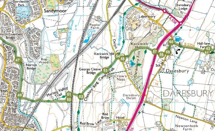
1 Route Pack Page 1 Route Summary A long distance linear walk on roads and country paths linking town and countryside to parks, woodlands and other open spaces. Grade Distance Accessibility Allow Start Map Long Distance 35km / 22 miles Fairly flat roads, paths and towpaths 8 hours Runcorn Hill Visitor Centre, Highlands Road, Runcorn OS Explorer 275 Liverpool & 276 Bolton, Wigan & Warrington

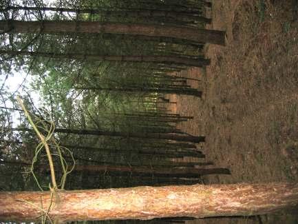
2 Route Pack Page 2 Route Details To the south of the River Mersey the land rises from sea level to the Cheshire plain 50-70m higher. Erosion has produced an edge, with several steep hillsides and outcrops of the underlying red sandstone. From the valley this gives a skyline view of a ridge of low hills, often wooded. The follows the edge of the high land, sometimes dropping down to the valley to offer views from both levels. Our local sandstone, with its pink colour and its sparkle, was a very popular building material in the nineteenth century. The biggest surviving quarry is at Runcorn Hill, though you can see others along the trail at several places. Runcorn Hill s quarries were at their peak in the late 1800s, and their stone was used in churches and public buildings in the town, but also went as far afield as New York. Other quarries along the trail were probably used only for local buildings, and may only have opened up when needed. All Saints Church at Daresbury, which was built in 1870 and features a stained glass window with characters from Lewis Carroll s Alice books, is said to have been built from stone quarried at Keckwick Hill. Lewis Carroll s father was the parson here. Victorian quarry workers were shocked to discover what looked like hand prints in the rock they were splitting open. These were made in Triassic times, 240 million years ago, when our area was in a part of the earth similar to Egypt or Ethiopia today, by an animal called Ticinosuchus ( tick-eye-no-soo-kus ), a forerunner of the dinosaurs. Ticinosuchus was a formidable meat eater, up to 2.5m long. You can see a life-size, breathing reconstruction in Warrington Museum, together with some of the original footprints. There are also the prints of the animals Ticinosuchus might have eaten small, plant-eating rhyncosaurs and early terrapins. Several small woodlands have survived along the route of the trail. In some cases these have developed from old quarries or on slopes too steep for farming, such as Daresbury Firs and Appleton Dingle. Woodpeckers, nuthatches, tree-creepers, sparrowhawks, peregrine falcons and buzzards all live in these woodlands. Holly blue butterflies, which have two generations of caterpillars each year, one feeding on holly buds in the spring, and the other on ivy buds in the autumn, are amongst the insect inhabitants. At Norton there is a Victorian water tower, representing a feat of engineering for its age, which stores water from Vyrnwy in Wales, passing along an aqueduct to Liverpool.
3 Route Pack Page 3 Route Directions From the Runcorn Hill Visitor Centre, walk towards the bowling greens. Before reaching them, turn left into the woodland. Head straight on, ignoring a path to the right and two to the left. Take the turning on the left that leads over the footbridge over the path you just left. Turn left off the path, with the cliff on your right. Join a wider path and head left along it. Turn left at the T junction and bear right past the houses to Weston Road. Follow Weston Road to the right. Bear left at the junction with Holloway, and follow it round to the right, passing two turnings on the left. Just after the Queen's Road turning on the right, head into an alley that goes straight on while the road bends slightly to the left. Cross Balfour Street and the footbridge over the railway. Take the third right, which is Fox Street, and enter the cemetery. Follow the paths through to the left-hand side of the cemetery and exit on to Victoria Road. Turn right along the road and follow it to the end. Go through the subway. Bear left. Bear right, rather than passing under the expressway. Cross Heath Road. Turn left behind the pub on to Sutton Street, which leads into Rock Park. Bear right past the bowling greens and tennis courts. Climb the steps up to Saxon Road and bear right across the crossroads. Enter Stenhills Park at the end of Saxon Road. Follow the waymarked paths through the park. Take the right-hand alley, which leads to Boston Avenue. Cross the road and walk along the road opposite. Turn left at the T junction along Halton Brook Avenue and follow it round to the right. Cross the footbridge on the left over the expressway. Turn right at the other side. From the end of the road, continue along the path into the park. Bear left across the open space. Turn right around the playground. Turn left down to Halton Link Road. Turn left along the path beside the road, crossing the busway The paths on the left lead towards historic Halton village and its ruined castle, but we continue straight on. Continue following the road. Cross Holt Lane and take the path opposite into Town Park. Walk diagonally across the open space. Bear right along the right-hand side of the trees. Follow the edge of the trees straight on. Follow the edge of the trees to Stockham Lane. Cross the lane and take the path to the left of the woods. Cross Norton Lane and enter Pickerings Rough, bearing right at the first junction. Bear right at the second junction. Bear right at the third junction. Bear right at the fourth junction out of the wood. Follow the path through the wood at Windmill Hill. Go straight on at the first crossroads. Go straight on at the second crossroads. Go through the subways under the busway and Hill Avenue West. Go straight on at the crossroads down to the Bridgewater Canal. Turn right on the canal towpath and follow it down to Norton Footbridge. Cross the bridge. Turn right on the opposite towpath and follow it down to Norton Town Footbridge. Turn left off the towpath. Continue straight on under the railway and over Keckwick Brook. Turn left after the brook. Turn right under a second railway line. Turn left on the towpath. Pass George Gleave's Bridge. Cross Keckwick Hill Bridge on Delph Lane. Before the first house turn left on to a path. Turn right around the house and into Daresbury Firs. Follow the waymarks through the wood, passing a viewpoint. Cross the main road. Turn left on the track into Daresbury village. Turn left on Chester Road. Opposite the Ring O Bells pub turn right into Daresbury Lane. Take the first left, Hall Lane. Follow the lane round to the right, then left. At the end, continue along the path. Turn left at the field end and right before the woodland. At the end of this block of woodland turn right torwards the corner of another, and follow the right-hand side of that block round to the right.
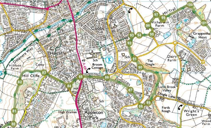
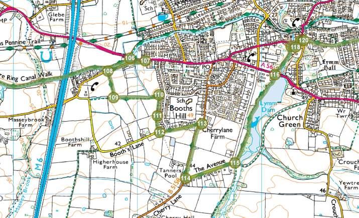
4 Route Pack Page 4 Route Directions (continued) Turn left to enter the woodland just before it ends. Pass through it, crossing the stream, and follow the field edge. Turn left down to Warrington Road. If you are in need of a break, the Hatton Arms is half a mile to the right. Turn left on the road. After passing Hatton Lodge on the left take the path on the right. Cross the field with the boundary on your left, and enter the next field. Turn left into the wood just after it begins. Continue just inside the wood past the ponds. Turn right about 300m in. Cross the stream and exit the wood. Follow the edge of the reservoir round to the right. Turn left around the reservoir. Turn left around the reservoir. The second time you meet Park Lane, turn right on to it. Turn left at the buildings. Enter and cross the third field on the left after the buildings. Pass into the next field with the woods on your right and follow the edge of the woods. Bear left away from the woods then right towards the cemetery. Take Windmill Lane opposite the gates of the cemetery. Turn left at the end on Quarry Lane. Cross London Road on to Lyon's Lane. Follow Lyon s Lane round to the right at the junction with Broom Avenue. At the end take the path through to the road opposite. Turn left at Dingle Lane. Take the path on the left into Appleton Dingle. Bear right at the junction of paths. Cross Witherwin Avenue. Turn right on Dale Lane. Take the path on the right across Lumb Brook. Bear right across the field. Turn left on Lumb Brook Road. Do not take the farm track on the right, but instead the path shortly afterwards through a narrow belt of woodland. Follow the path round to the right. And round to the left. Follow the left-hand edge of the trees to a track Turn right through a gap in the trees, past the end of the housing estate. 101 Cross a paved path, keeping the trees to your left Turn left on the track through the trees. Turn right when you reach the Broad Lane T junction. Turn left on to a path after the strip of woodland, and follow it between the patches of woodland and gardens to Canal Side, where you turn left towards the bridge. At the canal, turn right on to the towpath on the far side. Follow the towpath for the next 3km (2 miles), until you reach Camsley Lane and Ditchfield's Bridge shortly after the motorway. Cross the bridge and follow the lane. Turn right into Massey Brook Lane. Take the path on the left. Turn left at the field end. Turn right along the path that runs behind the houses. Pass the end of Hilltop Road. Turn left at Booths Lane. Turn right at the T junction on to Cherry Lane. Turn left on to The Avenue. Turn left on the path before the bridge into Lymm Dam woods. Cross Church Road. Cross the next bridge. Follow the road round to the left to Lymm Cross. Turn right behind the cross. Take Pepper Street (straight on). This becomes a path (Sutch Lane). Cross Oughtrington Lane and pass through the yard into Spud Wood. Enter the wood and head straight on. Cross the fence and bear left down to the canal, through the young woodland. Exit the woodland near the bridge. Cross the canal on Grantham's Bridge and take the path straight on. Reach the Woodland Trust car park on Stage Lane which is the end of the Trail.

5 Route Pack Page 5

6 Route Pack Page 6

7 Route Pack Page 7

8 Route Pack Page 8
The Mendip Way. Route Directions and Maps Uphill to Wells
 The Mendip Way Route Directions and Maps Uphill to Wells Website: www.mendiphillsaonb.org.uk Email: mendip@mendiphillsaonb.org.uk Facebook & Twitter: @MendipHillsAONB Phone: 01761462338 1 Uphill to Loxton
This path goes past an old tree nursery and sawmill. After 800m it crosses over a lane. Follow the bridleway fingerpost into the woods.
 FRENSHAM PONDS 11K CIRCULAR TRAIL 2½ HRS GU10 2DA This magnificent heathland trail starts in woodland and then brings you out onto the open heather of Frensham Common, with no roadwork! The route runs
Walk 1. Cotswold Water Park. Gateway Centre to Cerney Wick, railway track to Lake 6, Gateway Centre.
 Cotswold Water ark Walk way A Swindon/ Cirencester Thomas and Severn Canal way to Cerney Wick, railway track to Lake, way. Spine Road East Hotel Time: hours (short walk km) Distance: km A level walk along
MANOR PARK, RUNCORN, CHESHIRE, WA7 1SY TO LET NEWLY REFURBISHED INDUSTRIAL UNITS FROM 3,277-14,902 SQ FT
 MANOR PARK, RUNCORN, CHESHIRE, WA7 1SY TO LET NEWLY REFURBISHED INDUSTRIAL UNITS FROM 3,277-14,902 SQ FT DESCRIPTION DESCRIPTION The site extends to 8.24 acres (3.335 hectares) and comprises 15 units within
Hay Wood, Rowington and Baddesley Clinton - Warwickshire
 Hay Wood, Rowington and Baddesley Clinton - Warwickshire Starts at Lay-by alongside Hay Wood 2 hours 30 minutes 5.5miles 8.8km Leisurely ID: 0.683 Developed by: John Clift Checked by: Andy Page www.ramblersroutes.org
Leaden Boot Challenge ROUTE INSTRUCTIONS
 Leaden Boot Challenge ROUTE INSTRUCTIONS Section 1 Alstonefield to Ilam From the village hall car park turn R then L and pass through the village keeping to the R to enter Church Street. Pass the Church
CWMGIEDD FROM ABERCRAVE
 Abercrave to Cwmgiedd Walk Page 1 Starting from The Abercrave Inn. Grid Ref: SN 824128 From the Abercrave Inn, an 11.3km (7 miles) walk to the foothills of the Cribarth Mountain, then through forest to
HARDMOORS 55 RACE ROUTE 2018 HELMSLEY - GUISBOROUGH
 HARDMOORS 55 RACE ROUTE 2018 HELMSLEY - GUISBOROUGH HELMSLEY - CHECKPOINT 1 (WHITE HORSE) 1. Leave RACE START, continue ahead on road (Baxtons Sprunt) At crossroads turn right down Canons Garth eventualy
Hindhead, Keffolds Copse and Gibbet Hill
 point your feet on a new path, Keffolds Copse and Gibbet Hill Distance: 6 km=4 miles Region: Surrey Author: Schwebefuss Refreshments: Punch Bowl Café moderate walking Date written: 14-apr-2015 Last update:
Woodland Walk If you enjoyed this walk there are two others available in the same area.
 The Woodland Walk 11-12 kilometres (7-8 miles) 4-5 hours Terrain: some easy hills Can be slippery when wet 5 stiles Unsuitable for a pushchair/wheelchair Uses OS map 197 Parking: Pulborough Station and
BURGHCLERE PARISH RIGHTS OF WAY
 BURGHCLERE PARISH RIGHTS OF WAY Full descriptions compiled by Neill & Miggie Bruce All photos Miggie Bruce FP23 on Ridgemoor, looking south, with FP22 crossing by the bush FP1. From C183 Aldern Bridge
The Copper Horse Lodge, Windsor Park George III statue and view of Windsor Castle Andy Oakes Julian P Guffogg Don Cload
 Trail Activity Area Type(s) Author Distance Ascent Location : BRKSTR0008 : Walk : Windsor and the South East : Country Escape : Andy Oakes : 5 miles / 8.1 km : 239 feet / 73 metres : SU947727 / SL4 2BT
The Longster Trail. 12 miles of walking between Chester and the Sandstone Ridge. The Mid-Cheshire Footpath Society
 The Mid-Cheshire Footpath Society The Longster Trail an easy, medium-distance trail between Chester and Helsby 12 miles of walking between Chester and the Sandstone Ridge About the Longster Trail Distance:
Leaden Boot Challenge 2016 ROUTE INSTRUCTIONS
 Leaden Boot Challenge 2016 ROUTE INSTRUCTIONS Section 1 Alstonefield to Ilam (CP2) From the village hall car park turn R then L and pass through the village keeping to the R to enter Church Street. Pass
West Wirral (Dee Estuary)
") View of Hilbre Island from West Kirby with walkers at low tide. West Wirral (Dee Estuary) West Kirby is the start of the 12 mile long Wirral Way, the backbone of Wirral Country Park, the old Hooton to
View of Hilbre Island from West Kirby with walkers at low tide. West Wirral (Dee Estuary) West Kirby is the start of the 12 mile long Wirral Way, the backbone of Wirral Country Park, the old Hooton to
Ivinghoe Beacon and the Grand Union
 1 Ivinghoe Beacon and the Grand Union Cheddington station - Horton Wharf - Ivinghoe - Ivinghoe Beacon - Bridgewater Monument - Aldbury - Tring station Length: 11 ¼ miles (18.3km) Underfoot: The first mile
Pontfadog. Walk A. Walk A
 Walk A A Bird s eye view of the village 2km. (1 1 /2 miles); height gain 45m. (150ft) about 45 minutes. Six minutes walk along the main road towards Glyn Ceiriog reach a signpost to Llwynmawr. Take the
Description for the Round Rotherham 8 December 2007
 Directions: L left R right ½L, ½R half left, half right X cross X Rds cross roads SA straight Codes: BR bridge FP footpath FB footbridge RWY railway CP car park RD road Description for the Leave Event
Ystwyth and Rheidol Bridleway Routes. Route 2:Llanilar Circular
 Ystwyth and Rheidol Bridleway Routes Route 2:Llanilar Circular Route overview and terrain: A long circle using connecting ridges with fine views to link the Rheidol and Ystwyth river valleys. The route
Aston Rowant Discovery Trail
 The walk was developed by Aston Rowant Parish Council. The Trail is stile-free and fully way-marked. The circular route is 5.3m but with the extension to a pub and hotel 6.2m. Key Main Aston Rowant Discovery
Beautiful Walks from the Blue Ball Inn
 Walk No. 2 WINSTONS WALK Countisbury, Wind Hill, Watersmeet, Ash Bridge and Winston s path. 5 Miles approx. Walking time- Two and a half hours approx. (Not including Breaks) OS 1:25,000 Sheet 64/74 Lynton
Beautiful Walks from the Blue Ball Inn
 Walk No. 5 RIVER VALLEYS AND MOOR Countisbury, Watersmeet, Hillsford Bridge, Cheriton, Shilstone Hill, Rockford and Chiselcombe. 8.5 MILES APPROX. Walking time four and a half hours approx. OS 1;25,000
Beamers Trail. Walk No.1. 6 miles. (easy with some moderate ascents and descents)
") Beamers Trail Walk No.1 6 miles (easy with some moderate ascents and descents) 1 BEAMERS TRAIL 6 miles (easy with som WALK The Warpers Trail forms part of the long distance Witton Weavers Way. This is
Beamers Trail Walk No.1 6 miles (easy with some moderate ascents and descents) 1 BEAMERS TRAIL 6 miles (easy with som WALK The Warpers Trail forms part of the long distance Witton Weavers Way. This is
Penn Common and Bramshaw Wood
 Trail Activity Type Terrain Author Distance Ascent Location : HAMPTR0025 : Walk : Pub : Towpaths and Cycle Tracks : Anne-Marie Edwards : 5.3 miles / 8.5 kms : 381 feet / 116 metres : SU253173 / SP5 2BZ
Walk 1: Highfield, Lob Wood and The River Wharfe
 Walk 1: Highfield, Lob Wood and The River Wharfe Start: The Hen Pen Garden, Main Street, Addingham LS29 0NS, SE 077 498. Alternative Start: Near Bolton Bridge SE 071 525 (see page 6). Full walk: 4.5 miles
ID: 283 Distance: 6.2 miles Height gain: 500 Metres Map: Explore OL 19 Contributor David and Chris Stewart
 Walkingworld Wild Boar Fell ID: 283 Distance: 6.2 miles Height gain: 500 Metres Map: Explore OL 19 Contributor David and Chris Stewart Features Birds, Great Views, Hills or Fells Description: Wild Boar
The Hundred Parishes
 The Hundred Parishes Walks from railway stations number 3 3 miles (5kms) circular walk from Stansted Mountfitchet Start & finish: Stansted Mountfitchet station. Ordnance Survey Explorer Map 195. Grid Reference:
Warpers Trail. Walk No miles. (Easy with a few, short steep ascents)
") Warpers Trail Walk No.4 8.5 miles (Easy with a few, short steep ascents) 4 WARPERS TRAIL 8.5 miles (easy with a WALK The Warpers Trail forms part of the long distance Witton Weavers Way. This walk combines
Warpers Trail Walk No.4 8.5 miles (Easy with a few, short steep ascents) 4 WARPERS TRAIL 8.5 miles (easy with a WALK The Warpers Trail forms part of the long distance Witton Weavers Way. This walk combines
UMASS CROSS-COUNTRY Trails
 UMASS CROSS-COUNTRY Trails 1) EGG (43 min) (A) From Cage proceed to North Pleasant street (by campus pond). Make left and head toward LGRT and pass School of Education. Pass Puffton Apt complex (on left)
GRINDLEFORD GALLOP 2018
 GRINDLEFORD GALLOP 2018 Route Information The Grindleford Gallop follows a fixed 21 mile route through the lanes and paths of Derbyshire. All competitors must follow this route. An OS map of the area with
3.1 Bowness-on-Solway to Carlisle
 3.1 Bowness-on-Solway to Carlisle Map panel 1 Distance 15 miles (24 km) Terrain minor roads, tracks, field paths and riverside footpath, muddy in places Grade easy, with gentle gradients on undulating
Ardingly Lake, Ouse Valley, Borde Hill
 point your feet on a new path Ardingly Lake, Ouse Valley, Borde Hill Distance: 14 km=9 miles or 12½ km=8 miles Region: West Sussex Author: Hautboy Refreshments: Borde Hill Map: Explorer 135 (Ashdown Forest)
Freefolk and Whitchurch
 Trail Activity Type Terrain Author Distance Ascent Location : HAMPTR0026 : Walk : Tea Shop : Towpaths and Cycle Tracks : Jean Patefield : 5.6 miles / 9 kms : 377 feet / 115 metres : SU487488 / RG28 7NN
23,817 SQ FT on a site of 1.7 acres
 2,8 SQ FT on a site of. acres LOCATION Runcorn is situated on the south bank of the River Mersey, approximately miles from Liverpool, 9 miles from Warrington and 0 miles from Manchester. The town has a
Tour Of Tameside The alternative tameside trail
 Tour Of Tameside The alternative tameside trail A 30 mile walk around the borough of Tameside taking in the Valleys of the Medlock, Etherow and Tame. The whole walk can be completed in one day by anyone
Bewl Water & the High Weald
 1 Bewl Water & the High Weald Stonegate station - Stonegate - Wallcrouch - Newbarn - Cousley Wood - Wood's Green - Wadhurst station Length: 9 ½ miles (15.3km) Underfoot: Large portions of this path are
Countryside Trails Dunkeld
 R A N G E R S E RV I C E Countryside Trails Dunkeld WELCOME Welcome to this southern end of Atholl Estates. The countryside here is a wonderful blend of lochs, woodland and heather moor. There is a large
Slad over to Pitchcombe and back
 The walk climbs up from Slad over Wickridge Hill, descends to near Pitchcombe, then climbs back over Wickridge hill and round the back of Slad. Page 1 Start Point: SO 8718 0732 The Woolpack, Slad Length:
Hadleigh Castle and Chalkwell Oaze
 1 Hadleigh Castle and Chalkwell Oaze Benfleet station Hadleigh Park Hadleigh Castle Leigh-on-Sea Chalkwell station A short stroll through the lush woods of Hadleigh Park high above the Thames-side marshes,
BISHOPSTONE CIRCULAR WALK
 BISHOPSTONE CIRCULAR WALK 4½ miles (7¼ km) - allow 2 hours (see maps on final pages) Introduction This walk is within the North Wessex Downs Area of Outstanding Natural Beauty and starts from the small,
Self-Guided Walk Malham, Gordale and Malham Tarn
 Self-Guided Walk Malham, Gordale and Malham Tarn Combine all the major geological attractions of Malham in this walk and hopefully leave enough time to enjoy the cafes, pubs and shops of the village. Malham
Medway Valley Orchards
 1 Medway Valley Orchards East Farleigh station - Kettle Corner - Farleigh Green - Buston Manor - Yalding - Yalding station Length: 6 ¾ miles (10.9km) Underfoot: Generally, this is a walk on good paths,
Great Falls National Park, Virginia
 Great Falls National Park, Virginia Despite having grown-up in the area, I had not seen Great Falls until I was near an adult. I used to think places like Great Falls only existed someplace else that you
START - UPHILL BEACH. (tidal!) The West Mendip Way is route-marked with these round blue signs
 The West Mendip Way is route-marked with these round blue signs") START - UPHILL BEACH Start Times: 10:30 11:15 12:00 Please allow sufficient time to check in with the marshals Start on the beach at the high water line (tidal!) The West Mendip Way is route-marked with
START - UPHILL BEACH Start Times: 10:30 11:15 12:00 Please allow sufficient time to check in with the marshals Start on the beach at the high water line (tidal!) The West Mendip Way is route-marked with
Chevening and the North Downs
 1 Chevening and the North Downs Dunton Green station - Chipstead - Chevening - Knockholt - Hawley's Corner - Botley Hill - Oxted station Length: 12 ¼ miles (19.7 km) Underfoot: Portions of the walk are
A Tour of the Valle del Gizio
 Walk 25 A Tour of the Valle del Gizio Walking time 5hrs 30mins (4hrs if Colle Mitra is omitted) Difficulty 2 (likely to be snowbound in winter months); 1 (if Colle Mitra is omitted) Ascent/descent 570m/570m
Key Information. Self-Guided Walk Corfe Castle to Swanage
 Self-Guided Walk Corfe Castle to Swanage A classic walk from the pretty village of Corfe Castle. Enjoy extensive views whilst walking along the wide ridge to the popular seaside town of Swanage, returning
PHOENIX PARK INCORPORATING THURNSCOE COMMUNITY WOODLAND
 PHOENIX PARK INCORPORATING THURNSCOE This popular site is known for its sculptures and climbing wall which can be seen as you meander around the park. Walking towards the top of the woodland you will pass
Chess & Gade. Chalfont & Latimer Station - Latimer - Chenies - Sarratt - Kings Langley Station. Length: 8 ¾ miles (14.25km)
") 1 Chess & Gade Chalfont & Latimer Station - Latimer - Chenies - Sarratt - Kings Langley Station Length: 8 ¾ miles (14.25km) Underfoot: Well-trodden paths, mainly firm in all weather conditions, though
1 Chess & Gade Chalfont & Latimer Station - Latimer - Chenies - Sarratt - Kings Langley Station Length: 8 ¾ miles (14.25km) Underfoot: Well-trodden paths, mainly firm in all weather conditions, though
Singleton and the South Downs
 point your feet on a new path Singleton and the South Downs Distance: 13½ km=8½ miles easy walking with a few steeper sections Region: West Sussex Author: Hautboy Refreshments: Singleton, Hill Barn Date
Sponsored by. statestreet.com
 /STATESTREETISLANDWALK #ISLANDWALKJSY Sponsored by statestreet.com Important Information If you forget everything else PLEASE remember the following.» Remember to check OUT of every checkpoint» If you
Bentley station - Alice Holt Forest - Frensham Great Pond - Rushmoor - Pitch Place - Gibbet Hill - Haslemere station
 1 Devil s Punch Bowl and Surrey Heaths Bentley station - Alice Holt Forest - Frensham Great Pond - Rushmoor - Pitch Place - Gibbet Hill - Haslemere station Length: 13 ¾ miles (22.0 km) Underfoot: Almost
Britain s oldest surviving water-balanced cliff lift
 44 3.6 Saltburn by the Sea to Sandsend Map panels 3 and 4 Distance 17 miles (27½ km) Terrain mostly grass and field paths which can be muddy; some pavement, beach and shore Grade undulating route, with
Lordenshaw. What are cup & ring marks?
 Lordenshaw Lordenshaw hill has one of the largest clusters of ancient cup and ring marked stones in the UK. We ve chosen four interesting spots we d like to share with you. What are cup & ring marks? The
STAGE 11 WERNIGHERODE HASSELFELDE
 Wernigerode Land Saxony Anhalt District Harz STAGE 11 WERNIGHERODE HASSELFELDE km24 + 631-530 race E Wernigerode is a town of Saxony Anhalt with 34.413 inhabitants in the district of Harz on the river
H U D S O N P A L I S A D E S
 14 H U D S O N P A L I S A D E S Hudson Palisades The southernmost sections of the Long Path follow the Hudson River and the Hudson Palisades north, staying close to the river and to civilization. Although
HARDMOORS ROUTE DESCRIPTION
 HARDMOORS 60 2016 ROUTE DESCRIPTION RACE START (GUISBOROUGH) - CHECKPOINT 2 (SALTBURN) DISTANCE 9 MILES CUT OFF TIME 1030 GRID REF OS 666 208 1. Leaving the Sea Cadets Hall, turn left onto the road and
Gritstone Trail. Walkers Guide. Follow the 35 mile / 56km trail through Cheshire s Peak District.
 Gritstone Trail Walkers Guide Follow the 35 mile / 56km trail through Cheshire s Peak District www.cheshireeast.gov.uk Walking the Gritstone Trail Where is the Gritstone Trail? Stride out along the Gritstone
A leisurely one mile stroll through the history of Aldershot s Manor park, considered by many as the most attractive and pleasant parts of our town.
 Figure 1 Entrance to Park from the Aldershot Green/Churchill road end A leisurely one mile stroll through the history of Aldershot s Manor park, considered by many as the most attractive and pleasant parts
Jerusalem Bay Track (Cowan to Brooklyn)
") Jerusalem Bay Track (Cowan to Brooklyn) 5 hrs 30 mins 13.4 km One way Hard track 4 654m This Cowan to Brooklyn Station walk is a popular section of the Great North Walk, with scenery ranging from foreshore
Jerusalem Bay Track (Cowan to Brooklyn) 5 hrs 30 mins 13.4 km One way Hard track 4 654m This Cowan to Brooklyn Station walk is a popular section of the Great North Walk, with scenery ranging from foreshore
Reigate Hill and Gatton Park
 point your feet on a new path Reigate Hill and Gatton Park Distance: 11½ km=7 miles easy-to-moderate walking or 2 walks of 6½ km=4 miles and 5½ km=3½ miles Region: Surrey Author: Schwebefuss Refreshments:
Cadburys World Warwick Castle from Alvechurch
 UK Canal Boating UK Canal Boating Escape with a canal boating holiday! Telephone : 01395 443545 Email : contact@ukcanalboating.com Booking Office : PO Box 57, Budleigh Salterton. Devon. EX9 7ZN. England.
Difficult Run Stream Valley Park
 Difficult Run Stream Valley Park The more intense mountain bikers have known about for Difficult Run for some time. Equestrians have known it longer. Eight miles of unpaved trail, the Rails to River Trail
C E N T R A L C A T S K I L L S
 120 C E N T R A L C A T S K I L L S Central Catskills Once out of the southern parts of the Catskills, the Long Path enters the more well traveled and civilized regions. The trail joins the Devil s Path,
Following the Worcester & Birmingham Canal Feeder in Kings Norton Visiting Lifford Reservoir & Wychall Reservoir. Lifford
 Worcester-Birmingham & Droitwich Canals Society SUMMER WALK Following the Worcester & Birmingham Canal Feeder in Kings Norton Visiting Lifford Reservoir & Wychall Reservoir Lifford Reservoir Wychall Reservoir
Nature Track. 900m. 789m. 2 hrs 3.1 km Circuit. Hard track 238m. Blue Mountains National Park
 Nature Track 2 hrs 3.1 km Circuit Hard track 238m Largely following the ridges around the top edge of Wentworth Falls, this track is incredibly beautiful. After taking in the great views at Edinburgh Castle
Control Description Sheet 1
 Control Description Sheet 1 Headings I0A Example M20 M21 M35 1 8.8km 250m Event Title Classes (optional) Course Code; Course length, Height climb Start location as if it was a control. First Control Description
M56. New Junction 11a Summary of the consultation report
 M56 New Junction 11a Summary of the consultation report August 2017 M56 New Junction 11a Summary of the public consultation The scheme The M56 New Junction 11a scheme is part of our continued programme
Morning Copse near Maidstone, Kent acres of Ancient Woodland with a pond, bluebells and mature oak. 26,500 (freehold)
") WOODS 4 SALE Phone: 01248 364 362 www.woods4sale.co.uk UK Woodland & Woods For Sale: Specialising in the Sales of Small Woodlands in England, Scotland and Wales for Recreation, Wildlife Conservation and
WOODS 4 SALE Phone: 01248 364 362 www.woods4sale.co.uk UK Woodland & Woods For Sale: Specialising in the Sales of Small Woodlands in England, Scotland and Wales for Recreation, Wildlife Conservation and
ASTLEY POINT. An Exclusive Restaurant Development
 ASTLEY POINT An Exclusive Restaurant Development Restaurant and wine bar development within an exclusive residential scheme alongside the East Lancashire Road. Set in high quality landscaped surroundings.
J11 I M56 I Cheshire. daresbury. park. the natural choice for business.
 J11 I M56 I Cheshire daresbury park the natural choice for business www.daresburypark.com Welcome to... Daresbury Park, a Business Park located on junction 11 of the M56, two junctions from the M6 close
3rd GRADE MINIMUM CONTENTS UDI 1: LANDSCAPES (5)
") 3rd GRADE MINIMUM CONTENTS UDI 1: LANDSCAPES (5) DIFFERENT LANDSCAPES A landscape is all the things that we see in a place. There are different types of landscapes. Mountain landscapes have mountains and
3rd GRADE MINIMUM CONTENTS UDI 1: LANDSCAPES (5) DIFFERENT LANDSCAPES A landscape is all the things that we see in a place. There are different types of landscapes. Mountain landscapes have mountains and
Eastbourne. Alfriston 3¾ 6 3¾ 6. Birling Gap. Exceat
 3.8a Alfriston to Eastbourne (footpath) Map panel 6 (page 64) Distance 10½ miles (17 km) Terrain valley walk initially, first along riverbank path then hillside paths above, including stretch through forest;
Arches of the. Sandflats Area. By Virginia Allen
 Arches of the Sandflats Area By Virginia Allen TABLE OF CONTENTS Introduction Dedication Road Log Arches 1. Perforated View Arch 2. Fee Booth Arch 3. Windsong Arch 4. Weird Arch 5. Resting Arch 6. Bike
The. History Walk. WWII Armaments factory
 The History Walk WWII Armaments factory 4.8-6.5 kilometres (3-4 miles) 2.5-3.5 hours Terrain: easy Can be slippery when wet No stiles Unsuitable for a pushchair/wheelchair Uses OS map 197 Parking: Pulborough
Amazon UK Services Ltd Foundry Point Halebank Industrial Estate
 Amazon UK Services Ltd Foundry Point Halebank Industrial Estate FOUNDRY LANE WIDNES CHESHIRE WA8 8TZ Last Mile Delivery Investment Opportunity SECURED TO THE UNDOUBTED COVENANT OF AMAZON UK SERVICES LTD
Approximate distance: 7.5 miles For this walk we ve included OS grid references should you wish to use them.
 Approximate distance: 7.5 miles For this walk we ve included OS grid references should you wish to use them. 6 5 7 8 4 1 2 Start End N 3 W E S Reproduced by permission of Ordnance Survey on behalf of HMSO.
Stephens State Park Trails
 TRAILS OF ALLAMUCHY MOUNTAIN & STEPHENS STATE PARKS Allamuchy Mountain and Stephens State Parks contain 28 marked trails providing access to diverse landscapes for walking, hiking, biking, bird-watching,
The 34 th Poppyline Marathon
 The 34 th Poppyline Marathon Saturday 9th June 2018 - Route Description Emergency number: 07906 404673 or 07597 052572 Ahd - Ahead BL - bear left BR - bear right BW - bridleway Cont - continue FB - footbridge
Gomshall station - Abinger Hammer - Abinger Common - Friday Street - Leith Hill - Coldharbour - Holmwood station
 1 To Leith Hill Gomshall station - Abinger Hammer - Abinger Common - Friday Street - Leith Hill - Coldharbour - Holmwood station Important note: this walk cannot currently be done wholly by train on a
(west) onto Charleston Boulevard. Drive 16 miles on Charleston and turn right into Red Rock
 onto Charleston Boulevard. Drive 16 miles on Charleston and turn right into Red Rock") Hike: North Peak and Ice Box Overlook up and back Trailhead: 2.5 miles up the Rocky Gap Road not mark Distance: 5 miles round trip Elevation gain: 2,694 feet Elevation Peak: 7,094 feet Time: 3 to 5 hours
Hike: North Peak and Ice Box Overlook up and back Trailhead: 2.5 miles up the Rocky Gap Road not mark Distance: 5 miles round trip Elevation gain: 2,694 feet Elevation Peak: 7,094 feet Time: 3 to 5 hours
Ricoh UK Ltd. Ricoh House, Manor Park, Tudor Road, Runcorn WA7 1TA Suitable for Freehold Owner Occupation (Short Term Investment Opportunity)
") Suitable for Freehold Owner Occupation (Short Term Investment Opportunity) Investment Summary A single let well specified distribution warehouse investment, providing a total accommodation,80 sq ft (,08.0
Suitable for Freehold Owner Occupation (Short Term Investment Opportunity) Investment Summary A single let well specified distribution warehouse investment, providing a total accommodation,80 sq ft (,08.0
WALK: A circular walk by the canal and through Roberts Park with a choice of a woodland extension.
 This walk has been downloaded from www.saltairevillage.info WALK: A circular walk by the canal and through Roberts Park with a choice of a woodland extension. Roger & Brownyn Clarke, 2004 Email: rogerclarke@saltairevillage.info
Mapledurham, Gallowstree and Shepherd s Green
 Mapledurham, Gallowstree and Shepherd s Green Pangbourne station Mapledurham Gallowstree Common Satwell Shepherd s Green Grey s Court Henley-on-Thames Length: 15 ½ miles (24.8km) Underfoot: Minor roads
VANGUARD HOUSE SCI-TECH DARESBURY
 VANGUARD HOUSE SCI-TECH DARESBURY VANGUARD HOUSE SCI-TECH DARESBURY Vanguard House is a building of striking architectural design located in the luxurious landscaped setting of Sci-Tech Daresbury. Sci-Tech
U3A WALK Harby Hose. Route Summary. Route Overview. Description. Waypoints. Harby. Stuart Galloway
 U3A WALK Harby Hose Stuart Galloway Route Summary A circular walk taking in Harby, Hose and the Grantham Canal. Route Overview Category: Walking Length: 7.310 km / 4.57 mi Parking: Village Hall School
Erskine Creek via Pisgah Rock and Jack Evans
 Erskine Creek via Pisgah Rock and Jack Evans 4 hrs 30 mins 7.1 km Circuit Very experienced only 6 421m This walk visits some great lookouts and explores the lower section of Erskine Creek. Most of the
WALKS AROUND WOODHURST
 WALKS AROUND WOODHURST With Walks To Woodhurst from North St. Ives Woodhurst is situated on the verge of an elevated tract of table land four miles north of St. Ives. Its footpaths vary from leafy lanes
Whiteside Mountain Land Owned by: Location: Trails:
 Whiteside Mountain Latitude: 35 05.123 N Longitude: 083 07.933 W Elevation: 1,503m Land Owned by: US Forest Service Nantahala Ranger District 828-524-6441 Location: Jackson County, NC Turn off of US Highway
Tacklers Trail. Walk No miles. (A walk with a couple of short steep slopes and some rough moorland paths)
") Tacklers Trail Walk No.3 9.5 miles (A walk with a couple of short steep slopes and some rough moorland paths) WALK 3 TACKLERS TRAIL 9.5 miles (moderate wi 1. Sunnyhurst Visitor Centre The Warpers Trail
Tacklers Trail Walk No.3 9.5 miles (A walk with a couple of short steep slopes and some rough moorland paths) WALK 3 TACKLERS TRAIL 9.5 miles (moderate wi 1. Sunnyhurst Visitor Centre The Warpers Trail
Black Hill Regional Park, Little Seneca Lake
 Black Hill Regional Park, ittle Seneca ake ittle Seneca ake, in Black Hill Regional Park, is a reservoir created after a previous drought struck the Washington area. The park is under Maryland-National
5 MAP SPECIFICATION FOR SKI-ORIENTEERING
 5 MAP SPECIFICATION FOR SKI-ORIENTEERING 5.1 General Maps for ski orienteering are based on the specifications for foot-orienteering maps. However in order to meet the specific requirements put on the
M56. New Junction 11a Report on the public consultation
 M56 New Junction 11a Report on the public consultation August 2017 M56 New Junction 11a - Report on the public consultation CONTENTS 1 EXECUTIVE SUMMARY... 1 2 INTRODUCTION... 3 2.1 Purpose of this report...
Pen Cerrig-calch prehistoric cairns
 Walk Information: Maps: OS Explorer OL13 Distance: 8 miles / 13 kilometres Duration: Allow at least 6 hours for the circular walk Difficulty: medium. Some narrow paths, occasionally rough underfoot Start
SAINT OSWALD S CHURCH. In the Parish of Hinstock
 SAINT OSWALD S CHURCH ( The stone Church with the warm heart ) In the Parish of Hinstock Introduction A road ran through Hinstock as long ago as Roman times when the springs which currently fill the Bearcroft
The Bridestone Rocks from Lydgate
 Print this page Back to results The Bridestone Rocks from Lydgate Ancient tracks and gritstone outcrops, with terrific views of the steepsided Cliviger Valley. Distance 5 miles (8km) Minimum time 2hrs
The Cleo s Bath North Side Hike
 The Cleo s Bath North Side Hike This hike is a cross-country hike from Pinecrest Lake to the north side of Cleo s Bath. It is quieter and much less crowded than the normal route, which goes up the south
SHEEPLEAS. Visitor Guide and Self-guided Trails
 SHEEPLEAS Visitor Guide and Self-guided Trails Sheepleas The Sheepleas is an interesting mix of woodland, scrub and open grassland, situated on the chalk of the North Downs. This diversity of habitats
CELEBRATE WEST GREENWICH GEOCACHING THROUGHOUT WEST GREENWICH
 CELEBRATE WEST GREENWICH GEOCACHING THROUGHOUT WEST GREENWICH The West Greenwich Land Trust (WGLT) is sponsoring Celebrate West Greenwich, an event designed to celebrate the beauty and history of scenic
Aeron & Arth walks 4 walks for all the family to enjoy
 Aeron & Arth walks walks for all the family to enjoy Please take note that the maps illustrating these walks are intended as a rough guide only. You should use the most recent version of the relevant Ordnance