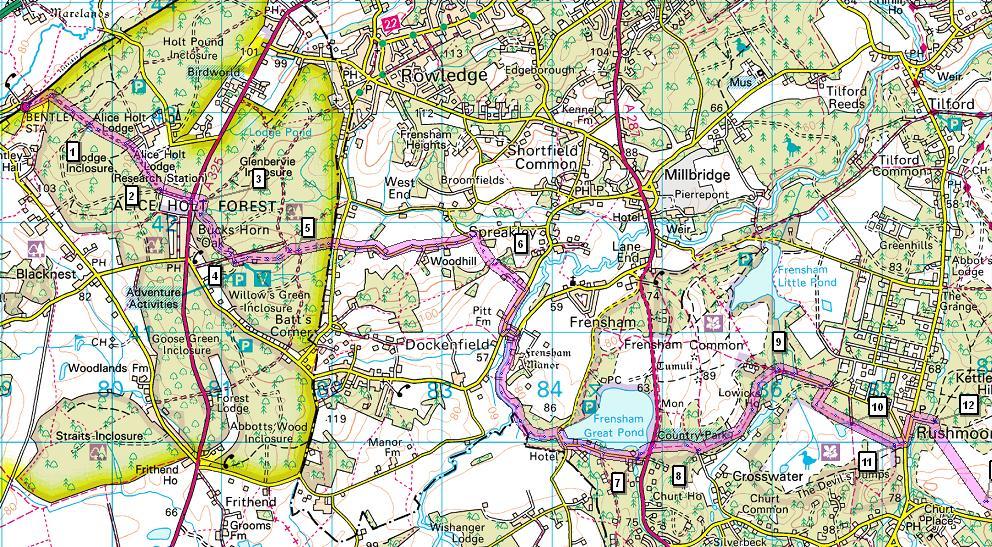
Bentley station - Alice Holt Forest - Frensham Great Pond - Rushmoor - Pitch Place - Gibbet Hill - Haslemere station
|
|
|
- Melinda Harmon
- 6 years ago
- Views:
Transcription
1 1 Devil s Punch Bowl and Surrey Heaths Bentley station - Alice Holt Forest - Frensham Great Pond - Rushmoor - Pitch Place - Gibbet Hill - Haslemere station Length: 13 ¾ miles (22.0 km) Underfoot: Almost entirely on well made paths, sandy soil or minor roads. A couple of short sections - along the River Wey and some of the beech woods just before Haslemere, will be muddy after rain. Good footwear recommended in any case due to terrain and length. Terrain: Steep climbs and ascents a couple of miles either side of the Punch Bowl. Otherwise, climbs and descents mainly gentle. Maps: 1:50,000 Landranger 186 Aldershot & Guildford; 1:25,000 Explorer 145 Guildford & Farnham and 133 Haslemere & Petersfield (note that the Explorer maps miss the first mile from Bentley - navigation is very easy on this section, however.) Getting there: Bentley is served by hourly South West Trains service daily from London Waterloo (69 minutes) via Clapham Junction for connections from London Victoria and London Overground services (62 minutes). Coming from Waterloo, it is normally quicker to take a fast train to Woking and change there for the Bentley service (journey time c.60 minutes) - this will show up on journey planner sites. Useful websites: The route passes through Alice Holt Forest, crosses the MoD training grounds of Hankley Common and through the National Trust properties of Hindhead Commons and the Devil's Punch Bowl. Getting home: Haslemere has 4 South West Trains services per hour (2 on Sundays) to London Waterloo (49-61 mins), with 2 of these each hour serving Clapham Junction (50 mins) for London Overground connections and services to London Victoria. Fares: Bentley and Haslemere are on diverging lines, so you will need to purchase two tickets to make these journeys. The cheapest combination is a London-Bentley Off Peak day return for (child 8.75, railcard 11.55) making sure you book to Bentley in Hampshire, not Bentley in South Yorkshire and a Super Off Peak single from Haslemere to Guildford for 5.70 (child 2.85, railcard 3.75). Whilst you won't pass through Guildford on your way from London to Bentley, travelling via Guildford is a 'permitted route' so your return ticket will be valid from Guildford. All Haslemere-Waterloo trains call at Guildford, so splitting your ticket there is unproblematic.
2 2
3 3
4 4 Route description Bentley station is a rather isolated wayside station, situated a mile south of the village it claims to serve, but with a row of railway houses next to the station. Until the 1970s, this line was an alternative route to Winchester and Southampton, and Bentley was a junction for a line serving the army camp at Bordon. The remaining line now ends a few miles west of here at Alton, and the line beyond Farnham has been reduced to single track, with Bentley as the only passing loop. Trains arriving from London can use either platform at Bentley, depending on whether they need to pass a train coming from Alton. If your train arrives on platform 1, walk to the London end of the platform and use the foot crossing across the tracks to access the path which leads off platform 2. Turn left, through the white footgate (signed to Alice Hall) along the tarmac path. Continue straight ahead past the Bentley Station Meadow nature reserve, after which the path curves south eastwards to climb steadily through the mixed woodland of Alice Holt Forest, with views back to the white houses of Bentley. At the junction at the top of the hill, by a pond [1], continue straight ahead. There is no Alice Holt - the forest, a former royal hunting ground, has had this name since the late 14th century, and it is thought to be a rather complex derivation from Ælfsige, a 10th century Bishop of Winchester, who had guardianship of the land on behalf of the king. The oak trees which once predominated the forest largely fell prey to the 18th and 19th centuries' insatiable desire for wooden warships, meaning that the Forest is now much more heavily coniferous than originally. Some of the remaining oak was used for the reconstruction of the Globe Theatre in London. Emerging at the edge of a clearing by the Forestry Commission's Research Centre's row of staff cottages, leave the tarmac and keep straight ahead on a broad path past the vehicle barrier (following Shipwright's Way waymarks). The path re-enters the woods. After around 500m, you reach a path junction [2] and head left (still on the Shipwright's Way) to reach the busy A325 Farnham-Bordon road, at the entrance to Bucks Horn Oak hamlet. Cross the main road with care and continue straight ahead back into the woods. At a junction by a bench [3], turn sharp right on a sandy forest track. Keep straight ahead along this track through a couple of dips to emerge at the wooden education centre buildings and the forest car park. Take the tarmac road ahead, before soon heading left at a barrier [4] on another forest road running between the café and cycle hire building. This easy track leads through the trees, to come to an end at a T-junction. Here take the track descending right to another junction [5], where you take the left hand fork. Before long, this path brings you to the edge of the forest to join Boundary Road. Continue ahead on minor Woodhill Lane almost opposite. Follow this pleasant lane for around 1 mile as it twists through the peaceful, rolling fields, passing Woodhill and Woodhill Farm. Just after the junction with Summer Hill Lane, at the brow of a hill, take the footpath waymarked to the right. At the edge of an open field, follow the vague direction of the signpost diagonally across it, heading for the stile in the far left hand corner. Over the stile, turn left then at the field corner follow a waymark right [6], dropping towards the large houses at Pitthanger, with views ahead across the Wey valley. The path joins a drive just below 19th century Pittshanger house, passes the attractive 16th century Kingswood to reach a road.
5 5 Turn right here - this road is quite busy, so take care - along the pleasant Wey valley, the riverside fields often full of grazing geese. Just past Pitt Farm, with its decapitated oast houses, turn left on Mill Lane. The road curves over the Wey, widened at this idyllic spot by the confluence of the main channel and mill leat. At the end of the bridge, turn right on the drive to The Mill House (there is a non-obvious bridleway sign). Past the houses, the bridlepath runs (muddy in places) close to the river. Ignore the footbridge to the right and keep beside river. The Wey eventually branches off to the south and you follow a smaller tributary, with bracken-covered slopes on the left. The path curves around the edge of a good-sized pool to emerge on Bacon Lane beside the much larger Frensham Great Pond. The pond is one of a pair (Frensham Little Pond is a mile to the north west across the common), much larger than something which would normally warrant the description of a 'pond'. These are 13th century artificial fish ponds, which when in use would have been drained every 5 years so that the fish could be harvested for the Bishop of Winchester. The Great Pond was more recently drained during World War II, to prevent it being used as a navigational aid by Luftwaffe pilots. In the film The Mummy the reed lined shores of the Great Pond stood in for the Nile. Turn right, and in front of Frensham Pond Hotel go left on Pond Lane, past the dinghy park. This road passes through woods, with glimpses of the Pond to the left through the trees. As you approach the main road, duck left at a bridleway waymark [7] on a clear path into the wood. Just before a wooden chicane, follow the bridleway waymark right to the A287. Cross this fast road with care and take the sandy bridleway opposite, onto Frensham Common, a lovely landscape of heather, birch and pine. Climb a low rise and keep straight ahead at the top on a sunken path, dropping to a large path junction [8]. Frensham Common is a 922 acre area of heathland, now forming a Site of Special Scientific Interest. Historically, the Common would have been a source of fuel for the local villages, but is now an important habitat for species including sand lizard, Dartford warblers and nightjars. Take the bridleway signed left. There are a lot of paths around here, most of which will end up in the right place if you keep in the correct direction. Generally, keep to the left hand path, keeping level and skirting the right hand edge of most of the trees. You will eventually catch glimpses of white Lowicks House through the wood to the right and shortly afterwards the path drops slightly to approach a small track amongst the trees. Follow the 'Cycle Route' waymark to cut right to this track and follow it left, almost immediately forking right on a track through woods towards the brick house at Grey Walls, just visible ahead. Past the house [9], join a small road ahead, crossing the footbridge next to the ford (after heavy rain there is likely to be a second ford too!). Continue ahead on the road (Sandy Lane) through the regimented scots pines. Immediately after passing the driveway to Lowicks House, turn right through a metal footgate (footpath sign) to follow a forestry track. On soon reaching a large junction/forestry vehicle turning circle on the edge of an expanse of heathland, turn left on the broad ride just inside the trees. Arriving at a gate [10], you can divert slightly right to visit the picturesque little pond of The Flashes. Otherwise, keep straight ahead on a wide fenced ride along the edge of the heath, from which there are fantastic views across the heathlands to the wooded hills of The Devil's Jumps. Just over a second rise, past a gate, follow the footpath waymark [11] left on a sandy path to a road on the edge of the scattered village of Rushmoor.
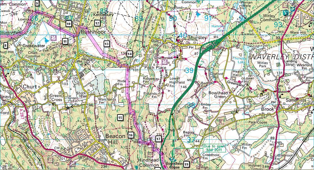
6 6 Keeping to the larger road, turn left. Just past a bus stop on the right hand side, cross and follow the wide path dropping straight ahead into a small valley. Having crossed the valley, you reach a track junction [12] with signs marking the edge of the MOD training area of Hankley Common. Along with much of Surrey's heathland, the huge expanse of Hankley Common is used by the MoD for training purposes, helping to protect it from housing and other development. This is a 'Managed Access' area, meaning that no live ammunition is used in training and there is public access throughout the Common at all times, though obviously you should be aware of any military activity and not disrupt it. The most intense activity on these commons occurred in the run-up the D-Day, where preparations included a reconstruction by Canadian troops of part of the Atlantic Wall coastal defences built by the occupiers along the northern coast of mainland Europe. Turn right, quickly coming to another junction on the edge of open heathland. Take the middle of the 3 tracks here, cutting diagonally left across the heath. Ignore the large track to the right, but where the route forks, take a broad path right, curving uphill on the bare heather slope ahead. At the top of the rise you cross a track and keep straight ahead on a path, heading along the ridge towards a house on the edge of woods. Eventually, you join a broad track [13] beside the heath boundary fence. Keep ahead on this track, climbing slightly. Paralleling the road, you pass a small car park and by the next telegraph pole [14], cut right on a path through the bracken to the road. Turn left with care on this busy, twisty road, past the cottages of Pitch Place, before turning right on a byway next to Little Pitch house. This track, much of it sunken, leads steadily uphill. At a fork, keep right to reach a minor road, where a bridleway continues the climb straight ahead. Another long sunken section leads you to a footgate into National Trust land. Keep to the broad path leading up the small wooded valley. Just before entering a grassy clearing with a pylon in centre, turn sharp left [15] on a gently climbing track (with a bridleway waymark). At a track junction on top of the ridge, keep straight ahead then veer right to drop towards Highcombe Bottom. Keep SA above an isolated cottage, the track now running along the valley side towards the hollow of the Devil's Punch Bowl at the head of the valley. After passing through a gateway about 500m beyond the cottage [16], turn L through a kissing gate on a steep path to the stream. The Devil's Punch Bowl is a large natural ampitheatre at the head of the Hindhead Valley, filled with heathland, woods and streams. The formation of the depression is believed to have been springs eroding the layer of clay which lies beneath the sandstone in this part of Surrey, then causing the sandstone above to collapse. Of course, there is a slightly more apocryphal version of the formation: that the devil, whilst engaged in digging a dyke through the South Downs so as to use the English Channel to flood the newly Christianised inhabitants of Sussex, was startled by a cock crowing. Believing that dawn was coming, he leapt from the Devil's Dyke, near Brighton, to here, where his landing caused the creation of the Punch Bowl. Take your pick. The Punch Bowl is now a very popular beauty spot, and a Site of Special Scientific Interest managed by the National Trust. Cross the footbridge and climb the steps leading out of the valley. Join the Youth Hostel's drive and continue uphill, passing pretty Highcombe Farm. Ignore the footpath to the right and continue steeply uphill on a tarmac road. At a fork by an information board [17], take the earth track to the right. Takes you across course of old A3, fast being actively returned to nature, to join another small tarmac road.
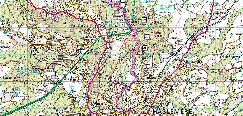
7 7 Since 1826, the main London to Portsmouth road climbed up the side of the Devil's Punch Bowl and up on to Hindhead Common. With steep gradients, this was always a slow part of the road, and as the rest of the A3 was upgraded, became to only bit of non-dual carriageway between London and Portsmouth - plans for widening were scuppered by the Punch Bowl's SSSI status. The Punch Bowl and Hindhead became notorious for peak hour congestion. A major trunk road running through hardly enhanced this incredible landscape, eventually leading to plans for a tunnel to take the A3 under the hills - at 1.2 miles, the longest road tunnel in the UK not running under an estuary. Construction started in 2007, and the tunnels opened in June 2011, transforming the area. Most maps, including the ones above, still show the surface route, but this has closed completely and is rapidly being returned to nature. Turn right on this lane, running along the wooded ridge, with glimpses down into the Punch Bowl on the right hand side. Where the road drops slightly to an area used for car parking [18], veer left at a metal barrier (waymarked as a National Trust permissive path), then take the first path on R to climb slightly to the open space on top of Gibbet Hill, with its Celtic cross, trig point and sweeping view. At 272m, Gibbet Hill is the second highest point in Surrey, with superb views to the north and east, including - on a clear day - the London skyline, nearly 40 miles away. The Celtic cross stands on the site of a former gallows, and is believed to have been erected by judge and Whig politician Sir William Erle in 1851 to dispel local fears of evil spirits. Take the path dropping ahead from the trig point. You soon reaches a complex path junction [19]. Turn right and immediately fork left (following a bridleway waymark), descending through a footgate. At another fork shortly afterwards, keep left. The path cuts across an open field and then re-enters the woods (this can sometimes be a muddy stretch). Join a track and keep straight ahead past small pond. Just after the point where the track swings right, fork right [20] on a waymarked bridleway down the side of the valley, through beech woods. On reaching a signposted junction [21], keep straight ahead on a footpath. The clear path runs through the wood, suddenly emerging by giant scots pines that dwarf the beeches. Shortly afterwards the path reaches a house and you follow the footpath sign left down the drive. You are now clearly in the stockbroker belt, as you pass large houses in fine gardens. At a crossroads, turn right on Bunch Lane. Follow this quiet road along the pleasant valley with scattered detached houses, for around 1 mile. As the houses become a bit denser, you can join a pavement on the left hand side. Just as the road swings right [22], turn left down a small tarmac drive (following a footpath sign). The path crosses a small stream and then follows it past a car park to reach a road junction by the railway bridge, with the Crown and Cushion pub just to your right. Pass under the railway and follow the road up the hill to reach Haslemere station.
Bewl Water & the High Weald
 1 Bewl Water & the High Weald Stonegate station - Stonegate - Wallcrouch - Newbarn - Cousley Wood - Wood's Green - Wadhurst station Length: 9 ½ miles (15.3km) Underfoot: Large portions of this path are
Hindhead, Keffolds Copse and Gibbet Hill
 point your feet on a new path, Keffolds Copse and Gibbet Hill Distance: 6 km=4 miles Region: Surrey Author: Schwebefuss Refreshments: Punch Bowl Café moderate walking Date written: 14-apr-2015 Last update:
Gomshall station - Abinger Hammer - Abinger Common - Friday Street - Leith Hill - Coldharbour - Holmwood station
 1 To Leith Hill Gomshall station - Abinger Hammer - Abinger Common - Friday Street - Leith Hill - Coldharbour - Holmwood station Important note: this walk cannot currently be done on a Sunday due to the
Gomshall station - Abinger Hammer - Abinger Common - Friday Street - Leith Hill - Coldharbour - Holmwood station
 1 To Leith Hill Gomshall station - Abinger Hammer - Abinger Common - Friday Street - Leith Hill - Coldharbour - Holmwood station Important note: this walk cannot currently be done wholly by train on a
The Mendip Way. Route Directions and Maps Uphill to Wells
 The Mendip Way Route Directions and Maps Uphill to Wells Website: www.mendiphillsaonb.org.uk Email: mendip@mendiphillsaonb.org.uk Facebook & Twitter: @MendipHillsAONB Phone: 01761462338 1 Uphill to Loxton
Hadleigh Castle and Chalkwell Oaze
 1 Hadleigh Castle and Chalkwell Oaze Benfleet station Hadleigh Park Hadleigh Castle Leigh-on-Sea Chalkwell station A short stroll through the lush woods of Hadleigh Park high above the Thames-side marshes,
This path goes past an old tree nursery and sawmill. After 800m it crosses over a lane. Follow the bridleway fingerpost into the woods.
 FRENSHAM PONDS 11K CIRCULAR TRAIL 2½ HRS GU10 2DA This magnificent heathland trail starts in woodland and then brings you out onto the open heather of Frensham Common, with no roadwork! The route runs
Pontfadog. Walk A. Walk A
 Walk A A Bird s eye view of the village 2km. (1 1 /2 miles); height gain 45m. (150ft) about 45 minutes. Six minutes walk along the main road towards Glyn Ceiriog reach a signpost to Llwynmawr. Take the
Chevening and the North Downs
 1 Chevening and the North Downs Dunton Green station - Chipstead - Chevening - Knockholt - Hawley's Corner - Botley Hill - Oxted station Length: 12 ¼ miles (19.7 km) Underfoot: Portions of the walk are
Leaden Boot Challenge ROUTE INSTRUCTIONS
 Leaden Boot Challenge ROUTE INSTRUCTIONS Section 1 Alstonefield to Ilam From the village hall car park turn R then L and pass through the village keeping to the R to enter Church Street. Pass the Church
Medway Valley Orchards
 1 Medway Valley Orchards East Farleigh station - Kettle Corner - Farleigh Green - Buston Manor - Yalding - Yalding station Length: 6 ¾ miles (10.9km) Underfoot: Generally, this is a walk on good paths,
Ystwyth and Rheidol Bridleway Routes. Route 2:Llanilar Circular
 Ystwyth and Rheidol Bridleway Routes Route 2:Llanilar Circular Route overview and terrain: A long circle using connecting ridges with fine views to link the Rheidol and Ystwyth river valleys. The route
Ranmore Common and Polesden Lacey
 point your feet on a new path Ranmore Common and Polesden Lacey Distance: 9½ km=6 miles Region: Surrey Author: Fusszweig Refreshments: Polesden Lacey easy walking Date written: 20-dec-2016 Last update:
Ivinghoe Beacon and the Grand Union
 1 Ivinghoe Beacon and the Grand Union Cheddington station - Horton Wharf - Ivinghoe - Ivinghoe Beacon - Bridgewater Monument - Aldbury - Tring station Length: 11 ¼ miles (18.3km) Underfoot: The first mile
Leaden Boot Challenge 2016 ROUTE INSTRUCTIONS
 Leaden Boot Challenge 2016 ROUTE INSTRUCTIONS Section 1 Alstonefield to Ilam (CP2) From the village hall car park turn R then L and pass through the village keeping to the R to enter Church Street. Pass
Chess & Gade. Chalfont & Latimer Station - Latimer - Chenies - Sarratt - Kings Langley Station. Length: 8 ¾ miles (14.25km)
") 1 Chess & Gade Chalfont & Latimer Station - Latimer - Chenies - Sarratt - Kings Langley Station Length: 8 ¾ miles (14.25km) Underfoot: Well-trodden paths, mainly firm in all weather conditions, though
1 Chess & Gade Chalfont & Latimer Station - Latimer - Chenies - Sarratt - Kings Langley Station Length: 8 ¾ miles (14.25km) Underfoot: Well-trodden paths, mainly firm in all weather conditions, though
Mapledurham, Gallowstree and Shepherd s Green
 Mapledurham, Gallowstree and Shepherd s Green Pangbourne station Mapledurham Gallowstree Common Satwell Shepherd s Green Grey s Court Henley-on-Thames Length: 15 ½ miles (24.8km) Underfoot: Minor roads
BURGHCLERE PARISH RIGHTS OF WAY
 BURGHCLERE PARISH RIGHTS OF WAY Full descriptions compiled by Neill & Miggie Bruce All photos Miggie Bruce FP23 on Ridgemoor, looking south, with FP22 crossing by the bush FP1. From C183 Aldern Bridge
river point your feet on a new path
 river point your feet on a new path Frensham and Bourne Wood Distance: 13 km=8 miles or 11 km=7 miles easy walking with a few steep gradients Region: Surrey Author: Schwebefuss Refreshments: Shortfield
Silver-washed Fritillaries in the Straits Inclosure in July
 ALICE HOLT FOREST Hampshire from www.discoverbutterflies.com the website for the book Discover Butterflies in Britain D E Newland Silver-washed Fritillaries in the Straits Inclosure in July Alice Holt
BISHOPSTONE CIRCULAR WALK
 BISHOPSTONE CIRCULAR WALK 4½ miles (7¼ km) - allow 2 hours (see maps on final pages) Introduction This walk is within the North Wessex Downs Area of Outstanding Natural Beauty and starts from the small,
Hay Wood, Rowington and Baddesley Clinton - Warwickshire
 Hay Wood, Rowington and Baddesley Clinton - Warwickshire Starts at Lay-by alongside Hay Wood 2 hours 30 minutes 5.5miles 8.8km Leisurely ID: 0.683 Developed by: John Clift Checked by: Andy Page www.ramblersroutes.org
Slad over to Pitchcombe and back
 The walk climbs up from Slad over Wickridge Hill, descends to near Pitchcombe, then climbs back over Wickridge hill and round the back of Slad. Page 1 Start Point: SO 8718 0732 The Woolpack, Slad Length:
Ardingly Lake, Ouse Valley, Borde Hill
 point your feet on a new path Ardingly Lake, Ouse Valley, Borde Hill Distance: 14 km=9 miles or 12½ km=8 miles Region: West Sussex Author: Hautboy Refreshments: Borde Hill Map: Explorer 135 (Ashdown Forest)
Beautiful Walks from the Blue Ball Inn
 Walk No. 5 RIVER VALLEYS AND MOOR Countisbury, Watersmeet, Hillsford Bridge, Cheriton, Shilstone Hill, Rockford and Chiselcombe. 8.5 MILES APPROX. Walking time four and a half hours approx. OS 1;25,000
CWMGIEDD FROM ABERCRAVE
 Abercrave to Cwmgiedd Walk Page 1 Starting from The Abercrave Inn. Grid Ref: SN 824128 From the Abercrave Inn, an 11.3km (7 miles) walk to the foothills of the Cribarth Mountain, then through forest to
Friday Street, Leith Hill, Holmbury Hill
 point your feet on a new path Friday Street, Leith Hill, Hill Distance: 12 km=7 miles easy-to-moderate walking + optional tour of Hill: 1½ km=1 mile Date written: 27-oct-2011 Region: Surrey Author: Schwebefuss
Walk 1. Cotswold Water Park. Gateway Centre to Cerney Wick, railway track to Lake 6, Gateway Centre.
 Cotswold Water ark Walk way A Swindon/ Cirencester Thomas and Severn Canal way to Cerney Wick, railway track to Lake, way. Spine Road East Hotel Time: hours (short walk km) Distance: km A level walk along
Fetcham Downs and Bocketts Farm A magical teashop walk
 point your feet on a new path Fetcham Downs and Bocketts Farm A magical teashop walk Distance: 3 km=2 miles or 4 km=2½ miles Region: Surrey Author: Fusszweig Refreshments: Bocketts Farm easy walking Date
ID: 283 Distance: 6.2 miles Height gain: 500 Metres Map: Explore OL 19 Contributor David and Chris Stewart
 Walkingworld Wild Boar Fell ID: 283 Distance: 6.2 miles Height gain: 500 Metres Map: Explore OL 19 Contributor David and Chris Stewart Features Birds, Great Views, Hills or Fells Description: Wild Boar
Reigate Hill and Gatton Park
 point your feet on a new path Reigate Hill and Gatton Park Distance: 11½ km=7 miles easy-to-moderate walking or 2 walks of 6½ km=4 miles and 5½ km=3½ miles Region: Surrey Author: Schwebefuss Refreshments:
START - UPHILL BEACH. (tidal!) The West Mendip Way is route-marked with these round blue signs
 The West Mendip Way is route-marked with these round blue signs") START - UPHILL BEACH Start Times: 10:30 11:15 12:00 Please allow sufficient time to check in with the marshals Start on the beach at the high water line (tidal!) The West Mendip Way is route-marked with
START - UPHILL BEACH Start Times: 10:30 11:15 12:00 Please allow sufficient time to check in with the marshals Start on the beach at the high water line (tidal!) The West Mendip Way is route-marked with
Cuxton, Ranscombe and Cobham
 1 Cuxton, Ranscombe and Cobham Cuxton station - Ranscombe - Cobham Park - Cobham - Sole Street station Length: 5 ¾ miles (9.4 km) Underfoot: Most of this walk is on well-made paths or tracks, with a few
HARDMOORS ROUTE DESCRIPTION
 HARDMOORS 60 2016 ROUTE DESCRIPTION RACE START (GUISBOROUGH) - CHECKPOINT 2 (SALTBURN) DISTANCE 9 MILES CUT OFF TIME 1030 GRID REF OS 666 208 1. Leaving the Sea Cadets Hall, turn left onto the road and
This walk has been checked as noted above, however the publisher cannot accept responsibility for any problems encountered by readers.
 Haslemere to Farnham 1 st walk check 2 nd walk check 3 rd walk check 25 th February 2017 Current status Document last updated Monday, 17 th September 2018 This document and information herein are copyrighted
Singleton and the South Downs
 point your feet on a new path Singleton and the South Downs Distance: 13½ km=8½ miles easy walking with a few steeper sections Region: West Sussex Author: Hautboy Refreshments: Singleton, Hill Barn Date
Bentley and Isington Mill Lower Froyle: The Anchor
 point your feet on a new path and Isington Mill Lower Froyle: The Anchor Distance: 12 km=7 miles Region: Hampshire Author: Botafuego Refreshments: Lower Froyle, easy walking Date written: 6-may-2012 Date
Baggy Point, Croyde, North Devon
 Baggy Point, Croyde, North Devon A walk using the South West Coast Path that is likely to be suitable for people with impaired mobility or with a pushchair, wheelchair, or mobility scooter. The Coast Path
HARDMOORS 55 RACE ROUTE 2018 HELMSLEY - GUISBOROUGH
 HARDMOORS 55 RACE ROUTE 2018 HELMSLEY - GUISBOROUGH HELMSLEY - CHECKPOINT 1 (WHITE HORSE) 1. Leave RACE START, continue ahead on road (Baxtons Sprunt) At crossroads turn right down Canons Garth eventualy
3.1 Bowness-on-Solway to Carlisle
 3.1 Bowness-on-Solway to Carlisle Map panel 1 Distance 15 miles (24 km) Terrain minor roads, tracks, field paths and riverside footpath, muddy in places Grade easy, with gentle gradients on undulating
Sponsored by. statestreet.com
 /STATESTREETISLANDWALK #ISLANDWALKJSY Sponsored by statestreet.com Important Information If you forget everything else PLEASE remember the following.» Remember to check OUT of every checkpoint» If you
Lewes and the South Downs
 point your feet on a new path and the South Downs Distance: 0 km=1½ miles moderate walking with long easy stretches Region: East Sussex Author: Hautboy Refreshments: Date written: 8-apr-013 Map: Explorer
The Bridestone Rocks from Lydgate
 Print this page Back to results The Bridestone Rocks from Lydgate Ancient tracks and gritstone outcrops, with terrific views of the steepsided Cliviger Valley. Distance 5 miles (8km) Minimum time 2hrs
Beautiful Walks from the Blue Ball Inn
 Walk No. 2 WINSTONS WALK Countisbury, Wind Hill, Watersmeet, Ash Bridge and Winston s path. 5 Miles approx. Walking time- Two and a half hours approx. (Not including Breaks) OS 1:25,000 Sheet 64/74 Lynton
Self-Guided Walk Langdale Pikes. Start & Finish: NT car park (free to members) at Sticklebarn - on the right just beyond the New Dungeon Ghyll hotel.
 at Sticklebarn - on the right just beyond the New Dungeon Ghyll hotel.") Self-Guided Walk Langdale Pikes Key Information These mountains form a collection of spires and cliffs on the north side of Langdale. This walk visits four of the main tops Pavey Ark, Harrison Stickle,
Self-Guided Walk Langdale Pikes Key Information These mountains form a collection of spires and cliffs on the north side of Langdale. This walk visits four of the main tops Pavey Ark, Harrison Stickle,
GRINDLEFORD GALLOP 2018
 GRINDLEFORD GALLOP 2018 Route Information The Grindleford Gallop follows a fixed 21 mile route through the lanes and paths of Derbyshire. All competitors must follow this route. An OS map of the area with
SHEEPLEAS. Visitor Guide and Self-guided Trails
 SHEEPLEAS Visitor Guide and Self-guided Trails Sheepleas The Sheepleas is an interesting mix of woodland, scrub and open grassland, situated on the chalk of the North Downs. This diversity of habitats
Skiing and Snowshoes on Un-groomed Fernan Saddle Terrain
 Skiing and Snowshoes on Un-groomed Fernan Saddle Terrain Three ski or snowshoe routes are available from the Fernan Saddle Parking Lot which either do not cover routes ordinarily groomed for snow machine
beach. Make the ford and follow the trail out to the junction with Red Creek Tr in an open grassy area.
 Description: This is a moderate to slightly strenuous 22.8 mile backpack (add 2.6 miles if you do the packless out and back to the Lion s Head) that will have you exploring nearly every thing that is The
Britain s oldest surviving water-balanced cliff lift
 44 3.6 Saltburn by the Sea to Sandsend Map panels 3 and 4 Distance 17 miles (27½ km) Terrain mostly grass and field paths which can be muddy; some pavement, beach and shore Grade undulating route, with
Much of the information which follows is included by kind permission of the Tynedale Council (now defunct) and is based on its brochure.
 and is based on its brochure.") The Tyne Green Trail This easy going circular walk is on level ground throughout. It follows the course of the River Tyne between Hexham Bridge and the turning point just past Watersmeet. The return is
The Tyne Green Trail This easy going circular walk is on level ground throughout. It follows the course of the River Tyne between Hexham Bridge and the turning point just past Watersmeet. The return is
A Circular Walk from Chapel Carn Brea
 A Circular Walk from Chapel Carn Brea 4.3 Miles A Walk Visiting Five Historic Ancient Sites This circular walk offers the possibility of several alternatives, depending on the walker s available time and
Mersey Valley Timberland Trail
 Route Pack Page 1 Route Summary A long distance linear walk on roads and country paths linking town and countryside to parks, woodlands and other open spaces. Grade Distance Accessibility Allow Start Map
The 34 th Poppyline Marathon
 The 34 th Poppyline Marathon Saturday 9th June 2018 - Route Description Emergency number: 07906 404673 or 07597 052572 Ahd - Ahead BL - bear left BR - bear right BW - bridleway Cont - continue FB - footbridge
A Tour of the Valle del Gizio
 Walk 25 A Tour of the Valle del Gizio Walking time 5hrs 30mins (4hrs if Colle Mitra is omitted) Difficulty 2 (likely to be snowbound in winter months); 1 (if Colle Mitra is omitted) Ascent/descent 570m/570m
Description for the Round Rotherham 8 December 2007
 Directions: L left R right ½L, ½R half left, half right X cross X Rds cross roads SA straight Codes: BR bridge FP footpath FB footbridge RWY railway CP car park RD road Description for the Leave Event
Distance: 18 km=11 miles or 12½ km=7½ miles or 9 km=5½ miles
 point your feet on a new path The Devil s Dyke Distance: 18 km=11 miles or 12½ km=7½ miles or 9 km=5½ miles Region: West Sussex Author: Hautboy Refreshments: Devil s Dyke, Fulking, Poynings moderate ing
Penn Common and Bramshaw Wood
 Trail Activity Type Terrain Author Distance Ascent Location : HAMPTR0025 : Walk : Pub : Towpaths and Cycle Tracks : Anne-Marie Edwards : 5.3 miles / 8.5 kms : 381 feet / 116 metres : SU253173 / SP5 2BZ
Gors Lydan barrows and medieval huts
 Walk Information: Maps: OS Explorer 214 Distance: 5.5 miles / 9 kilometres Duration: 4.5 to 5 hours Difficulty: Easy. Good paths and no steep gradients Start and finish: SO 11977545 Walk summary The walk
River Isla B951. Diarmid s Tomb
 3. 4 Spittal of Glenshee to Kirkton of Glenisla Distance 14.6 miles 23.5 km Terrain mainly on rough moorland path with boggy bits and stream crossings, then heading east along at the B951 for 2.5 miles,
The Hundred Parishes
 The Hundred Parishes Walks from railway stations number 3 3 miles (5kms) circular walk from Stansted Mountfitchet Start & finish: Stansted Mountfitchet station. Ordnance Survey Explorer Map 195. Grid Reference:
Self-Guided Walk Malham, Gordale and Malham Tarn
 Self-Guided Walk Malham, Gordale and Malham Tarn Combine all the major geological attractions of Malham in this walk and hopefully leave enough time to enjoy the cafes, pubs and shops of the village. Malham
From the car park go through the wooden gate and walk to a large information board and wooden totem pole ahead of you.
 Trail Dave Price, Geograph (CCL) Twin peaks What are these striking wooded hills here in an otherwise flat landscape? Time: 40-60 mins Distance: 1 ¼ miles Landscape: rural Standing at over 300 feet tall
Delamere Loop. The. Useful Businesses Equestrian Escapes Tailor-made horse riding holidays in Cheshire. Tel:
 The Loop Accommodation Providers Akesmere Bed & Breakfast OS Grid Ref. SJ589/669 B&B for horse and rider. Chester Road, Little, Tarporley, Cheshire CW6 9ER Tel: 01829 760348 www.akesmerefarm.co.uk Useful
Beamers Trail. Walk No.1. 6 miles. (easy with some moderate ascents and descents)
") Beamers Trail Walk No.1 6 miles (easy with some moderate ascents and descents) 1 BEAMERS TRAIL 6 miles (easy with som WALK The Warpers Trail forms part of the long distance Witton Weavers Way. This is
Beamers Trail Walk No.1 6 miles (easy with some moderate ascents and descents) 1 BEAMERS TRAIL 6 miles (easy with som WALK The Warpers Trail forms part of the long distance Witton Weavers Way. This is
Eastbourne. Alfriston 3¾ 6 3¾ 6. Birling Gap. Exceat
 3.8a Alfriston to Eastbourne (footpath) Map panel 6 (page 64) Distance 10½ miles (17 km) Terrain valley walk initially, first along riverbank path then hillside paths above, including stretch through forest;
Freefolk and Whitchurch
 Trail Activity Type Terrain Author Distance Ascent Location : HAMPTR0026 : Walk : Tea Shop : Towpaths and Cycle Tracks : Jean Patefield : 5.6 miles / 9 kms : 377 feet / 115 metres : SU487488 / RG28 7NN
COSTA BLANCA MOUNTAIN WALKERS - WALK DESCRIPTION. Visit for more walks descriptions in Spain
 Visit www.walksinspain.org for more walks descriptions in Spain Walk description originally prepared by:- Ralph Phipps Last Updated 15 th July 2016 Title of Walk Location of Start (include name of nearest
Approximate distance: 7.5 miles For this walk we ve included OS grid references should you wish to use them.
 Approximate distance: 7.5 miles For this walk we ve included OS grid references should you wish to use them. 6 5 7 8 4 1 2 Start End N 3 W E S Reproduced by permission of Ordnance Survey on behalf of HMSO.
The Copper Horse Lodge, Windsor Park George III statue and view of Windsor Castle Andy Oakes Julian P Guffogg Don Cload
 Trail Activity Area Type(s) Author Distance Ascent Location : BRKSTR0008 : Walk : Windsor and the South East : Country Escape : Andy Oakes : 5 miles / 8.1 km : 239 feet / 73 metres : SU947727 / SL4 2BT
Sutton and Hollesley Heaths Walk Guide
 Outstanding Landscapes Sutton and Hollesley Heaths Walk Guide Explore the unique and rare landscape of the Sandlings heath and its diversity of wildlife and history. The Suffolk Coast & Heaths Area of
Aeron & Arth walks 4 walks for all the family to enjoy
 Aeron & Arth walks walks for all the family to enjoy Please take note that the maps illustrating these walks are intended as a rough guide only. You should use the most recent version of the relevant Ordnance
Merritts Traverse. 1928m
 Merritts Traverse 3 hrs Hard track 5.8 km Circuit 4 167m This walk starts with a scenic journey to the top of the hill on the chairlift. Starting along Merritts Nature walk, this walk soon detours down
Coast Survey Stretch 07 Freshwater Bay LBS to Yarmouth Bridge
 Coast Survey Stretch 07 Freshwater Bay LBS to Yarmouth Bridge Overview map of the stretch Introduction This section includes Headon Warren and West High Down SSSI, Colwell Bay SSSI and part of Yar Estuary.
Lordenshaw. What are cup & ring marks?
 Lordenshaw Lordenshaw hill has one of the largest clusters of ancient cup and ring marked stones in the UK. We ve chosen four interesting spots we d like to share with you. What are cup & ring marks? The
Aston Rowant Discovery Trail
 The walk was developed by Aston Rowant Parish Council. The Trail is stile-free and fully way-marked. The circular route is 5.3m but with the extension to a pub and hotel 6.2m. Key Main Aston Rowant Discovery
Staples Lookout to Mt Wondabyne loop
 Staples Lookout to Mt Wondabyne loop 4 hrs 3 mins 1.8 km Circuit Hard track 337m This walk starts and finishes at Staples Lookout, on Woy Woy Rd. The walk follows sections of the Great North Walk around
A novel character. Discover what shaped the landscape that so inspired the Brontës. Directions
 Trail A novel character Discover what shaped the landscape that so inspired the Brontës Time: 1-1 ½ hrs Distance: 1 ½ miles Landscape: rural The small village of Haworth in West Yorkshire is most famous
Farley Green Surrey Hills Guide 799,950 Freehold. Holmbury St Mary, Surrey, 1,175,000 F/H
 Farley Green Surrey Hills Guide 799,950 Freehold Holmbury St Mary, Surrey, 1,175,000 F/H A rarely available detached character converted stable block situated in the much sought after hamlet of Farley
Broxbourne Woods Brickendon, Ermine Street, Wormley West End
 point your feet on a new path Broxbourne Woods Brickendon, Ermine Street, Wormley West End Distance: 10 km=6 miles (+ 1.2 km=0.8 mile for north pub) easy walking or two walks of 7 km=4½ miles (south) and
Approximate distance: 4.5 miles For this walk we ve included OS grid references should you wish to use them. Start. End
 Approximate distance: 4.5 miles For this walk we ve included OS grid references should you wish to use them. 2 1 Start End 4 3 N W E S Reproduced by permission of Ordnance Survey on behalf of HMSO. Crown
Coast Path Survey Stretch 09 Shalfleet Mill to Thorness Bay
 Coast Path Survey Stretch 09 Shalfleet Mill to Thorness Bay Overview Map of stretch Introduction This stretch of Island coast covers several salt marsh creeks backed by grazing land and woodland on the
Hill Ridge House TILFORD ROAD HINDHEAD SURREY GU26 6RL
 Hill Ridge House TILFORD ROAD HINDHEAD SURREY GU26 6RL Hill Ridge House TILFORD ROAD HINDHEAD SURREY GU26 6RL A DISTINCTIVE COUNTRY HOUSE SET IN TEN ACRES OF PRIVATE VALLEY WITH STUNNING VIEWS. Set within
Wicklow Mountains Path Survey
 Wicklow Mountains Path Survey Glenmacnass Tonelagee Start to Finish: O 114 030 to O 085 016 Altitude (lowest highest): 370m 817m Weather: Sunny day, hot Access: Military Road, Glenmacnass Surveyed by:
Tour Of Tameside The alternative tameside trail
 Tour Of Tameside The alternative tameside trail A 30 mile walk around the borough of Tameside taking in the Valleys of the Medlock, Etherow and Tame. The whole walk can be completed in one day by anyone
s point your feet on a new path
 s point your feet on a new path Arundel: Park, Hills and Forests Distance: 20 km=12½ miles Region: West Sussex Author: Hautboy Refreshments: Arundel, Houghton, Whiteways Lodge moderate walking Date written:
Leura Cascades to Gordon Falls Reserve
 Leura Cascades to Gordon Falls Reserve 1 hr 15 mins 1.8 km One way Moderate track 200m From Leura Park to Gordon Falls Park, this diverse walk offers fantastic views of the Jamison Valley, as well as two
Victoria Falls Lookout to Blue Gum Forest
 Victoria Falls Lookout to Blue Gum Forest 8 hrs Experienced only 13.8 km One way 5 112m This long day-walk follows a remote track down from Victoria Falls lookout, passing the waterfall, and into the Grose
Woodland Walk If you enjoyed this walk there are two others available in the same area.
 The Woodland Walk 11-12 kilometres (7-8 miles) 4-5 hours Terrain: some easy hills Can be slippery when wet 5 stiles Unsuitable for a pushchair/wheelchair Uses OS map 197 Parking: Pulborough Station and
Newlands Corner Leaflet 08:Newlands Corner Leaflet 5/10/09 11:58 Page 1
 Newlands Corner Leaflet 08:Newlands Corner Leaflet 5/10/09 11:58 age 1 St Martha s is the start of the Downs Link, a 33-mile long distance trail linking the North Downs Way with the South Downs Way at
GOLDEN EARS PROVINCIAL PARK
 GOLDEN EARS PROVINCIAL PARK Trail Information as of October 10 th 2015 Do not underestimate the mountainous wilderness of Golden Ears Provincial Park. The combination of rugged terrain and rapidly changing
Grimbosq Battlefield Tour RMD and our UK contingent are working up a scenario about the battle of the Grimbosq bridgehead in Normandy.
 Grimbosq Battlefield Tour RMD and our UK contingent are working up a scenario about the battle of the Grimbosq bridgehead in Normandy. We wargamers often forget that when we push our toys around the table,
Basingstoke Canal and Dogmersfield
 point your feet on a new path? Basingstoke Canal and Dogmersfield Distance: 11 km=7 miles easy ing or 2 s of 7½ km=4¾ miles and 5¼ km=3¼ miles Region: Hampshire Author: Botafuego Refreshments: The Barley
Beachy Head and Eastbourne
 point your feet on a new path Beachy Head and Eastbourne Distance: 2 km=4½ miles Region: East Sussex Author: Stivaletti moderate walking Date written: 25-jun-200 & 6-jun-205 Last update: 28-feb-208 Refreshments:
from the website for the book Discover Butterflies in Britain D E Newland 2009
 BEACON HILL Hampshire from www.discoverbutterflies.com the website for the book Discover Butterflies in Britain D E Newland 2009 Beacon Hill lies at the western end of the South Downs, southeast of Winchester.
Congewai Track Head (East) to Watagan Headquarters
 to Watagan Headquarters") Congewai Track Head (East) to Watagan Headquarters 7 hrs Hard track 17.2 km One way 4 973m This full day walk starts from the Congewai valley trackhead (east) and follows the Great North Walk up into the
Congewai Track Head (East) to Watagan Headquarters 7 hrs Hard track 17.2 km One way 4 973m This full day walk starts from the Congewai valley trackhead (east) and follows the Great North Walk up into the
Steep and Shoulder of Mutton Hill
 Trail Summary Trail Activity Type Author Distance Ascent Location : HAMPTR0073 : Walk : Pub : Nick Channer : 5.7 miles / 9.1 kms : 794 feet / 242 metres : SU745253 / GU32 2DD With its spectacular beech
Segment 2: La Crescent to Miller s Corner
 goal of the USFWS refuges is to conserve, protect and enhance fish, wildlife and plants and their habitats for the continuing benefit of the American people. Refuge lands are used largely for fishing,
Mt Kuring-gai Track to Berowra station
 Mt Kuring-gai Track to Berowra station 4 hrs 15 mins 9.7 km One way Hard track 4 553m This walk explores three valleys, with great displays of wild flowers in spring, and some nice sandstone overhangs.
Countryside Trails Dunkeld
 R A N G E R S E RV I C E Countryside Trails Dunkeld WELCOME Welcome to this southern end of Atholl Estates. The countryside here is a wonderful blend of lochs, woodland and heather moor. There is a large