Bonaqua Mountain Hardware Action Sprint 2013 Discovery Bay,Lantau The Course Route
|
|
|
- Posy Boyd
- 5 years ago
- Views:
Transcription


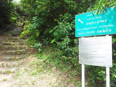
1 Bonaqua Mountain Hardware Action Sprint 2013 Discovery Bay,Lantau The Course Route The start is inside the Discovery Bay plaza and leads out to the main sandy beach where you will run to the end of the beach, by the children s swings.
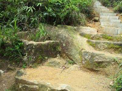
 then up a long set of mountain stairs to the top of a hill, turn left and the trail and stairs")

2 Along the beach After running around the swings you will exit onto a cement road path and go up a short set of stairs, cross the main road (look both ways) then up a long set of mountain stairs to the top of a hill, turn left and the trail and stairs will wind back down to the main Discovery Bay road. This will take the fastest 20 minutes and 30 minutes for the average. You will have to cross the road so please be careful and look both ways before crossing and will be opposite the river entrance.


3 Turn right and then quick left up stairs

4 Right turn at the junction and then left to main road Cross the road
5

6 Looking back


7 Down Stairs to road Looking back at top of stairs


8 Turn left on the cement road Straight thru view point


9 Left turn Left at same junction


10 Left on cement path Into water catchment and follow it

11 Follow Trail


12 Go between buildings (small rope from tree down to road) Right turn (between buildings)


13 Right turn at the bottom of stairs Cross road over railing into river
")

14 Looking back After railing turn right in river. You will have to climb over the small road barrier (1m high) then go into the river and turn right. You will stay in the river rock scrambling m before taking the right river turn at a river junction

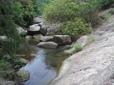
15 . Right turn into river


16 Under bridge (go under bamboo) River right up rocks


17 Same junction and turn right River left


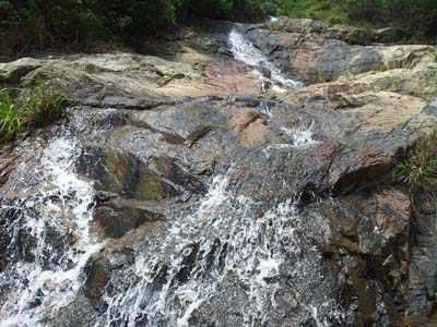
18 Stay in river Climb side of waterfall


19 Go up rocks to road (not thru tunnel) and turn right on road


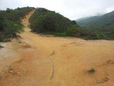
20 Turn right and follow road up This is where the water cp will be on this road. Now turning right on the road you will stay on the road 200m before going left on the first major trail junction and follow this trail to the very top of Lo Fu Tau where a timing checkpoint will be. Left turn on trail near top of road


21 Next left on main trail Left main trail up to top of Lo Fu Tau


22 Main trail pass Lo Fu Tau trig pole. Continue thru the Mtn top CP and take the first left junction down a steep mountain trail. Be very careful on this downhill as there are some rocks at the beginning of this trail and if you are going to fast (race leaders!!!) it is very easy to fall and injure yourself. Nice view


23 Follow main trail and stay left Nice view


24 Main trail stay left Stay left


25 Left turn 200m after Lo Fu Tau down small trail to reservoir Follow small trail to reservoir


26 Down trail to reservoir Main trail to reservoir


27 You will see the reservoir on your right side and walk down slowly into the reservoir for a small dunking in the water. You will have to swim along the rocks around 10 m so it is not really a swim but more a cooling measure to bring your body temperature down after the mountain climb that you will appreciate. Over catchment down to reservoir


28 Turn right immediately into reservoir Swim or walk along rocks in water to cool down. When exiting the reservoir, the Bonaqua/Aquarius water checkpoint will be there. This is around 5.6 km into the course so far.


29 Water Check Point and turn right on road. You will then continue along the main road towards the golf course entrance staying left hitting the first left trail entrance before the golf course. Turn left off road into small trail before golf course tunnel (Note some construction on golf course so slight detour off original trail but same direction.


30 Turn left off road into small trail Follow small trail watch for golf balls


31 (NEW)Left turn on new trail Watch out dangerous metal stairs


32 Watch out dangerous metal stairs Main road turn right up hill


33 (Same junction) Main road turn right up hill Near top of road turn left into trail


34 Follow main trail left Follow main trail

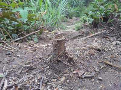
35 Watch out for tree stub Watch out for tree stub


36 Left turn on original trail Follow main trail straight

, until you")
37 Left turn down hill Same junction follow main trail left on down hill. This downhill trail will be around 500 m (watch out for loose rock as easy to twist your ankle), until you reach the cement path by the Monastery.


38 Turn left at monastery Same junction left down road at monastery


39 Left turn off main road into cement trail to DB. Turn left on the cement road and run down a very steep cement road for around 300 m before another sharp left turn on a cement path leading to DB direction. Same trail. This path will take you m before some houses so please respect the people that live there as they could be walking on this narrow footpath.
 then cut back onto the footpath next")
40 Turn right thru fence down to beach next to house. At beach turn left and follow coastline. When you hit the beach by the first set of houses you will go straight to the beach and run 600 m along the coastline (easy flat beach with some rocks) then cut back onto the footpath next to you and take the cement footpath all the way back to Discovery Bay passing thru Nim Shue Wan.

41 Follow coastline Follow coastline


42 Follow coastline Left turn on beach up short 10m trail to house and turn right on cement path to Nim Shue Wan


43 Same junction leaving coastline Same junction leaving coastline and right turn in front of house


44 Follow main path straight Right turn into village


45 Follow main path at Nim Shue Wan Left turn on main road (watch out for buses)


46 Left turn and cross main road to La Costa building Right turn into La Costa


47 After right into La Costa then immediate left turn to playground. You will cross the main road and run directly across the street by the La Costa apartments where you will see a children s playground you will cut thru. Watch out for children!!!!after right into La Costa then immediate left turn to playground


48 Into La Costa straight down path and left by playground towards ocean Left turn by ocean


49 Looking back same junction. This small path will lead you to the water front promenade next to the ferry pier where you will run 200m along until you are right in front of the ferry by the bus terminal. Right turn at bus station by pier


50 In front of ferry pier 100m to finish and left turn Straight thru plaza watch out for people. Run up a path and come out by the Pacific Coffee and stay close to the buildings with Wildfire close to you on your right side heading towards McSorelys Irish bar direction. Finish line in front of McSorelys Irish bar in square.

51 AGAIN WATCH OUT FOR PEOPLE WHEN RUNNING INTO SQUARE. Showers at end of beach by swings. Also some water taps around the gardens but pressure is not always strong. TOILETS IN MAIN DISCOVERY BAY PLAZA AREA No bottles are to be taken away from check point. See course map on website. Shorter Course If any competitors want to drop out at the water checkpoint by the reservoir and not go further they will marked on the time sheet as DNF. Please notify the race control timing at the finish line immediately if you do this so we are not looking for you on the race course as we don t want to send the emergency rescue after you and only find out you are at home already. So please inform us at the finish line timing if you drop out. Cut off: If competitors take more than 2 hours (11:00am) to do the first 4km of trail and river gorge they will be re-routed to the reservoir and given a time penalty for not doing the Lo Fu Tau mountain section. Anyone taking more than 3 hours (12:00noon) to get to the reservoir 2nd water check point (6km) will be not allowed to continue and directed down the road direct to the finish line at DBay plaza and given DNF.
Leaden Boot Challenge 2016 ROUTE INSTRUCTIONS
 Leaden Boot Challenge 2016 ROUTE INSTRUCTIONS Section 1 Alstonefield to Ilam (CP2) From the village hall car park turn R then L and pass through the village keeping to the R to enter Church Street. Pass
Leaden Boot Challenge ROUTE INSTRUCTIONS
 Leaden Boot Challenge ROUTE INSTRUCTIONS Section 1 Alstonefield to Ilam From the village hall car park turn R then L and pass through the village keeping to the R to enter Church Street. Pass the Church
The Mendip Way. Route Directions and Maps Uphill to Wells
 The Mendip Way Route Directions and Maps Uphill to Wells Website: www.mendiphillsaonb.org.uk Email: mendip@mendiphillsaonb.org.uk Facebook & Twitter: @MendipHillsAONB Phone: 01761462338 1 Uphill to Loxton
Answers to Your Turn. Chapter 2. Maps and mapping
 Geog. 1 Answers to Your Turn Chapter 2. Maps and mapping Chapter 2.1 Mapping connections 1. A = Isle of Man; B = Northumberland; C = Cornwall; D = Surrey; E = Shrewsbury; F = Nigeria; G = Japan; H = China;
Beautiful Walks from the Blue Ball Inn
 Walk No. 5 RIVER VALLEYS AND MOOR Countisbury, Watersmeet, Hillsford Bridge, Cheriton, Shilstone Hill, Rockford and Chiselcombe. 8.5 MILES APPROX. Walking time four and a half hours approx. OS 1;25,000
Victoria Falls Lookout to Blue Gum Forest
 Victoria Falls Lookout to Blue Gum Forest 8 hrs Experienced only 13.8 km One way 5 112m This long day-walk follows a remote track down from Victoria Falls lookout, passing the waterfall, and into the Grose
GRINDLEFORD GALLOP 2018
 GRINDLEFORD GALLOP 2018 Route Information The Grindleford Gallop follows a fixed 21 mile route through the lanes and paths of Derbyshire. All competitors must follow this route. An OS map of the area with
DAY 1: Circular Quay to Greenwich Wharf
 DAY 1: Circular Quay to Greenwich Wharf Total Distance: 14km Time: Approximately 5 hours Walk Notes in Six Sections Section Name Length Time 1:1 Circular Quay to Milsons Point Station 2.5km 50mins 1:2
UMASS CROSS-COUNTRY Trails
 UMASS CROSS-COUNTRY Trails 1) EGG (43 min) (A) From Cage proceed to North Pleasant street (by campus pond). Make left and head toward LGRT and pass School of Education. Pass Puffton Apt complex (on left)
Potato Chip Grinder. Sheet1
 Potato Chip Grinder MILE DIRECTIONS FOR 0 START: Albertsons 5 Woodland Pkwy San Marcos, CA. (OPEN:00:00 CLOSE:+0:00) Obtain proof of start from local business with time & date stamp. Exit parking lot toward
Leura Cascades to Gordon Falls Reserve
 Leura Cascades to Gordon Falls Reserve 1 hr 15 mins 1.8 km One way Moderate track 200m From Leura Park to Gordon Falls Park, this diverse walk offers fantastic views of the Jamison Valley, as well as two
GOLDEN EARS PROVINCIAL PARK
 GOLDEN EARS PROVINCIAL PARK Trail Information as of October 10 th 2015 Do not underestimate the mountainous wilderness of Golden Ears Provincial Park. The combination of rugged terrain and rapidly changing
Sponsored by. statestreet.com
 /STATESTREETISLANDWALK #ISLANDWALKJSY Sponsored by statestreet.com Important Information If you forget everything else PLEASE remember the following.» Remember to check OUT of every checkpoint» If you
Griffith Park Trail Run Trail Guide Click for
 The Griffith Park Trail Run by Hike- LosAngeles.com Griffith Park Trail Run Trail Guide Click for downloadable cell phone guide and map from EveryTrail. DISTANCE: 4.55 Miles ELEVATION: 1280' ELEVATION
Location Hazard Description Our Controls What you and your party need to do Outside
 The following information is provided to assist visiting teachers and group leaders in completing their own risk assessment prior to their visit. It is not intended to be a replacement for a group leader-conducted
Hornsby station to Crosslands
 Hornsby station to Crosslands 6 hrs 45 mins 16.1 km One way Hard track 4 938m This section of the Great North Walk starts from Hornsby train station and winds down along the Blue Gum Walk into Fishponds.
TURN BY TURN DIRECTIONS
 TURN BY TURN DIRECTIONS START/FINISH CITI FIELD, PARKING LOT 2 Continue out of Parking Lot E to Shea Road Turn left, going southeast along Shea Road to the traffic circle Bear left and run clockwise around
A Tour of the Valle del Gizio
 Walk 25 A Tour of the Valle del Gizio Walking time 5hrs 30mins (4hrs if Colle Mitra is omitted) Difficulty 2 (likely to be snowbound in winter months); 1 (if Colle Mitra is omitted) Ascent/descent 570m/570m
Driving instructions to Kotor Vista and Kotor Muo from Dubrovnik airport
 Driving instructions to Kotor Vista and Kotor Muo from Dubrovnik airport We will assume you are coming straight from the airport. If you are not doing so, please inform us so we can plan accordingly. Turn
HARDMOORS 55 RACE ROUTE 2018 HELMSLEY - GUISBOROUGH
 HARDMOORS 55 RACE ROUTE 2018 HELMSLEY - GUISBOROUGH HELMSLEY - CHECKPOINT 1 (WHITE HORSE) 1. Leave RACE START, continue ahead on road (Baxtons Sprunt) At crossroads turn right down Canons Garth eventualy
Merritts Traverse. 1928m
 Merritts Traverse 3 hrs Hard track 5.8 km Circuit 4 167m This walk starts with a scenic journey to the top of the hill on the chairlift. Starting along Merritts Nature walk, this walk soon detours down
The North Face 100 Hong Kong
 The North Face 100 Hong Kong TNF 100 and TNF 50 HONG KONG ROUTE DESCRIPTIONS Both the 50 km and 100 km races start at 8 AM on Saturday, December 16 th inside the Tai Mei Tuk car park in the Northern New
HARDMOORS ROUTE DESCRIPTION
 HARDMOORS 60 2016 ROUTE DESCRIPTION RACE START (GUISBOROUGH) - CHECKPOINT 2 (SALTBURN) DISTANCE 9 MILES CUT OFF TIME 1030 GRID REF OS 666 208 1. Leaving the Sea Cadets Hall, turn left onto the road and
Victoria Falls and Grose Valley to Blackheath Station
 This walk explores a fantastic section of the Grose Valley. Starting above Victoria Falls, the walk explores the cascades before dropping into the valley for the first nights rest at Burra Korain campsite.
Nature Track. 900m. 789m. 2 hrs 3.1 km Circuit. Hard track 238m. Blue Mountains National Park
 Nature Track 2 hrs 3.1 km Circuit Hard track 238m Largely following the ridges around the top edge of Wentworth Falls, this track is incredibly beautiful. After taking in the great views at Edinburgh Castle
Model 205 Fireview Maintenance Kit
 Model 205 Fireview Maintenance Kit Please read all of the instructions before you begin the procedure. Confirm that you have all the necessary tools and parts required. Allow about one hour to complete
In the following pages you can find the driving directions from the airport to your villa in Almyrida.
 Dear guests! We are looking forward to welcoming you in Almyrida soon! In the following pages you can find the driving directions from the airport to your villa in Almyrida. You will find the keys in the
1. Drive to Lake Cowichan via Highway 18 (which connects to the Trans-Canada Highway just north of Duncan)
") Driving Instructions to the Walbran Valley via Lake Cowichan (updated July 2018) 1. Drive to Lake Cowichan via Highway 18 (which connects to the Trans-Canada Highway just north of Duncan) 2. At the traffic
Driving Instructions to the Walbran Valley via Lake Cowichan (updated July 2018) 1. Drive to Lake Cowichan via Highway 18 (which connects to the Trans-Canada Highway just north of Duncan) 2. At the traffic
Mt Kuring-gai Track to Berowra station
 Mt Kuring-gai Track to Berowra station 4 hrs 15 mins 9.7 km One way Hard track 4 553m This walk explores three valleys, with great displays of wild flowers in spring, and some nice sandstone overhangs.
Bewl Water & the High Weald
 1 Bewl Water & the High Weald Stonegate station - Stonegate - Wallcrouch - Newbarn - Cousley Wood - Wood's Green - Wadhurst station Length: 9 ½ miles (15.3km) Underfoot: Large portions of this path are
1. Waterfall Gully Mt Lofty. 5 Of the Best Hikes in Adelaide
 Adelaide is a beautiful city, and one of the most incredible things about Adelaide is the quality of bushwalking available on the suburban fringe. It is surrounded by the Mt Lofty Ranges, and much of the
START - UPHILL BEACH. (tidal!) The West Mendip Way is route-marked with these round blue signs
 The West Mendip Way is route-marked with these round blue signs") START - UPHILL BEACH Start Times: 10:30 11:15 12:00 Please allow sufficient time to check in with the marshals Start on the beach at the high water line (tidal!) The West Mendip Way is route-marked with
START - UPHILL BEACH Start Times: 10:30 11:15 12:00 Please allow sufficient time to check in with the marshals Start on the beach at the high water line (tidal!) The West Mendip Way is route-marked with
The 34 th Poppyline Marathon
 The 34 th Poppyline Marathon Saturday 9th June 2018 - Route Description Emergency number: 07906 404673 or 07597 052572 Ahd - Ahead BL - bear left BR - bear right BW - bridleway Cont - continue FB - footbridge
Description for the Round Rotherham 8 December 2007
 Directions: L left R right ½L, ½R half left, half right X cross X Rds cross roads SA straight Codes: BR bridge FP footpath FB footbridge RWY railway CP car park RD road Description for the Leave Event
Staples Lookout to Mt Wondabyne loop
 Staples Lookout to Mt Wondabyne loop 4 hrs 3 mins 1.8 km Circuit Hard track 337m This walk starts and finishes at Staples Lookout, on Woy Woy Rd. The walk follows sections of the Great North Walk around
Oman Trek Trek the dramatic and beautiful scenery of Oman
 Oman Trek Trek the dramatic and beautiful scenery of Oman Discover Oman on this breath taking 5 day challenge. The mountain ranges and deserts of Oman offer spectacular trekking, and enables you to experience
Skiing and Snowshoes on Un-groomed Fernan Saddle Terrain
 Skiing and Snowshoes on Un-groomed Fernan Saddle Terrain Three ski or snowshoe routes are available from the Fernan Saddle Parking Lot which either do not cover routes ordinarily groomed for snow machine
Section 7: Pick Up Where You Left Off! S-Tree Road over the Todd Road
 2018 TRACE NOTES Helpful information for your adventure on Section 7 of the Hiker Challenge. Start Point S-Tree Rd. End Point Intersection Todd Rd. / Hale Ridge Rd. WEATHER DECISION Weather Alert!!!! Potential
BRR Leg 1 (3.9 miles, Easy)
") BRR Leg 1 (3.9 miles, Easy) Min 3901 Max 4919 Ascent +21 Descent -1031 0.0 Start (Grayson Highlands State Park Visitor Center) 3.9 Grayson Highlands State Park Office & Gate, on R (EZ 1) Leg Notes: Minimal
BRR Leg 1 (3.9 miles, Easy) Min 3901 Max 4919 Ascent +21 Descent -1031 0.0 Start (Grayson Highlands State Park Visitor Center) 3.9 Grayson Highlands State Park Office & Gate, on R (EZ 1) Leg Notes: Minimal
Walk 1. Cotswold Water Park. Gateway Centre to Cerney Wick, railway track to Lake 6, Gateway Centre.
 Cotswold Water ark Walk way A Swindon/ Cirencester Thomas and Severn Canal way to Cerney Wick, railway track to Lake, way. Spine Road East Hotel Time: hours (short walk km) Distance: km A level walk along
Jerusalem Bay Track (Cowan to Brooklyn)
") Jerusalem Bay Track (Cowan to Brooklyn) 5 hrs 30 mins 13.4 km One way Hard track 4 654m This Cowan to Brooklyn Station walk is a popular section of the Great North Walk, with scenery ranging from foreshore
Jerusalem Bay Track (Cowan to Brooklyn) 5 hrs 30 mins 13.4 km One way Hard track 4 654m This Cowan to Brooklyn Station walk is a popular section of the Great North Walk, with scenery ranging from foreshore
Directions. IBM Recovery Center One Evertrust Plaza Jersey City, NJ From World Trade Center site (Downtown New York City):
:") Directions IBM Recovery Center One Evertrust Plaza Jersey City, NJ 07302 1. Path Train From World Trade Center site (Downtown New York City): - Path Train service from World Trade Center site to Exchange
Directions IBM Recovery Center One Evertrust Plaza Jersey City, NJ 07302 1. Path Train From World Trade Center site (Downtown New York City): - Path Train service from World Trade Center site to Exchange
Charnley Explorer June 24 - July 15, 2018 Bachsten Creek and the Charnley River. Second draft: 14 November 2017
 Charnley Explorer June 24 - July 15, 2018 Bachsten Creek and the Charnley River. Second draft: 14 November 2017 The best part of the original section one is now part of out Gibb Road Gorges trip. The dates
Girrakool to Wondabyne station
 Girrakool to Wondabyne station 4 hrs Hard track 9.5 km One way 4 438m This walk starts from the Girrakool picnic area and winds south, through the Brisbane Waters National Park. The walk crosses some long
Wentworth Pass. 893m. 535m. 4 hrs. Hard track 5.1 km Circuit. 692m
 Wentworth Pass 4 hrs Hard track 5.1 km Circuit 4 692m This walk offers a great way to explore the magical, upper section of the Valley of the Waters. The walk starts and finishes at Conservation Hut, which
Slad over to Pitchcombe and back
 The walk climbs up from Slad over Wickridge Hill, descends to near Pitchcombe, then climbs back over Wickridge hill and round the back of Slad. Page 1 Start Point: SO 8718 0732 The Woolpack, Slad Length:
Blackheath to Blue Gum loop
 Blackheath to Blue Gum loop 2 Days Hard track 24.1 km Circuit 4 1335m This walk is great for fit people getting into overnight walking, with its fantastic scenery and nostalgia as a classic overnighter.
Gunung Stong trekking log
 Gunung Stong trekking log Description of group We are a group of 13 average trekkers. (Gone on at least 2 treks before) Summary of activities 14 th May 2002: Depart on overnite train from JB to Dabong
Girrakool to Wondabyne station via Pindar caves
 Girrakool to Wondabyne station via Pindar caves 7 hrs 30 mins 18.1 km One way Experienced only 5 741m This walk starts from the Girrakool picnic area and winds south, following Piles creek into the Brisbane
Berowra Waters to Cowan Station
 Berowra Waters to Cowan Station 3 hrs 30 mins 7.2 km One way Hard track 597m This is a hilly walk out of the beautiful Berowra Waters valley to Cowan Station. There are many wide views across Berowra Creek
Introduction to Safety on Glaciers in Svalbard
 Introduction to Safety on Glaciers in Svalbard Content Basic info on Svalbard glaciers Risk aspects when travelling on glaciers Safe travel on glaciers UNIS safety & rescue equipment Companion rescue in
Kirigalpoththa Nature Trail Horton Plains National Park
 Kirigalpoththa Nature Trail Horton Plains National Park Trail Difficulty: Easy Moderate Strenuous Tough Trail Head: Horton Plains Visitor Centre Nearest Town: Pattipola Nearest City: Nanu-Oya Access to
TNF 100 and TNF 50 HONG KONG ROUTE DESCRIPTIONS 2018 VARIATIONS
 TNF 100 and TNF 50 HONG KONG ROUTE DESCRIPTIONS 2018 VARIATIONS In the aftermath of Super Typhoon Mangkhut, licensing authorities closed segments of Section 2 and Section 3 of our race course. It is rerouted
Patonga to Wondabyne station via Mt Wondabyne
 Patonga to Wondabyne station via Mt Wondabyne 7 hrs 3 mins 19.5 km One way Hard track 4 861m This walk explores some grand views, pleasant cascades, varied bushland and remote areas of Brisbane Waters
June 2008 Ride Schedule
 June 2008 Ride Schedule Saturday Sunday May 31 June 1 San Leandro to Yosemite Ride, Castro Valley to Jamestown 5/SB/130 If you are up for the challenge of a two day ride from Castro Valley to the valley
Barefoot International / Fly High Fat Sac Filling and Emptying Options
 Barefoot International / Fly High Fat Sac Filling and Emptying Options We are not trying to convince you one way or the other, but we want you to be able to make an informed decision about what is best
FUNTASTIC SUMMER AT DISCOVERY BAY
 Press release For immediate release FUNTASTIC SUMMER AT DISCOVERY BAY Challenge Your Skills and Valour on the Beach and at DB North Plaza with 8m Gigantic Water Slide x Inflatable Playground x Beach Arena!
This path goes past an old tree nursery and sawmill. After 800m it crosses over a lane. Follow the bridleway fingerpost into the woods.
 FRENSHAM PONDS 11K CIRCULAR TRAIL 2½ HRS GU10 2DA This magnificent heathland trail starts in woodland and then brings you out onto the open heather of Frensham Common, with no roadwork! The route runs
Opening Date: The Bronx Zoo is opening two new attractions that will feature three exciting experiences.
 Opening Date: The Bronx Zoo is opening two new attractions that will feature three exciting experiences. Bronx Zoo Treetop Adventure (Climb and Zipline) will open to the public on Friday, July 7. Nature
DAY 3: Huntleys Point Wharf to Balmain East Wharf
 DAY 3: Huntleys Point Wharf to Balmain East Wharf Total Distance: 14.5km Time: Approximately 5 hours Walk Notes in Five Sections Section Name Length Time 3:1 Huntleys Point Wharf to Iron Cove Bridge 4km
Wicklow Mountains Path Survey
 Wicklow Mountains Path Survey Ballinacor Croaghanmoira Fananierin Start to Finish: T 11723 86602 to T 11175 89057 Altitude (lowest highest): 385m 664m Weather: Hot Access: Coolgarrow forest entrance Surveyed
Staithes Treasure Hunt
 www.cluesgo.co.uk Staithes Treasure Hunt Follow the route and answer the questions. A great afternoon with beautiful views. Children have fun spotting things. Older ones exercise your brains on harder
National Pass. 893m. 665m. 3 hrs 30 mins 4.6 km Circuit. Hard track 773m. Blue Mountains National Park
 National Pass 3 hrs 3 mins 4.6 km Circuit Hard track 773m 4 This walk offers fantastic views of the Jamison Valley and the surrounding cliffs. Take time to explore the historic and very scenic ledge halfway
YOSEMITE TO SAN FRANCISCO CYCLE
 USA CYCLE DEMANDING ABOUT THE CHALLENGE Journey from the spectacular Yosemite National Park to the Pacific Coast, finishing with an unforgettable finish at the iconic Golden Gate Bridge into San Francisco.
Hindhead, Keffolds Copse and Gibbet Hill
 point your feet on a new path, Keffolds Copse and Gibbet Hill Distance: 6 km=4 miles Region: Surrey Author: Schwebefuss Refreshments: Punch Bowl Café moderate walking Date written: 14-apr-2015 Last update:
Kinder Joy Discovery Bay Easter Egg Hunt on the Beach 2018
 Press Release For Immediate Release Kinder Joy Discovery Bay Easter Egg Hunt on the Beach 2018 Jointly organised by Discovery Bay and Baby-mo Magazine, the one-of-a-kind event in town Kinder Joy Discovery
Self-Guided Walk Botallack to Land s End
 Self-Guided Walk Botallack to Land s End A beautiful coastal walk rich in industrial heritage, wildlife and swimming opportunities too. Ending at Land's End. Michael Carpenter, route researcher Key Information
BISHOPSTONE CIRCULAR WALK
 BISHOPSTONE CIRCULAR WALK 4½ miles (7¼ km) - allow 2 hours (see maps on final pages) Introduction This walk is within the North Wessex Downs Area of Outstanding Natural Beauty and starts from the small,
WELCOME TO LANDAL EBELTOFT
 WELCOME TO LANDAL EBELTOFT Dear guest, We look forward to welcoming you as a guest at Landal Ebeltoft. To help you prepare, we ve put together this flyer for you. If you have any questions or comments,
MudCrew : The Roseland August Trail (RAT) : 2019 EVENT GUIDE
 : 2019 EVENT GUIDE") MudCrew : The Roseland August Trail (RAT) : 2019 EVENT GUIDE MudCrew presents: The Roseland August Trail (RAT) Series 2019 Thank you for interest in the 2019 Roseland August Trail (RAT) Race Series. The
MudCrew : The Roseland August Trail (RAT) : 2019 EVENT GUIDE MudCrew presents: The Roseland August Trail (RAT) Series 2019 Thank you for interest in the 2019 Roseland August Trail (RAT) Race Series. The
Map: Kompass Hunsrück/Obere Nahe 3061 Kompass Rheinhessen Rheingau Naheland, Mainz 3089
 The Tandem Club International Rally 2017 Oberhausen/Nahe Germany GPS file: ITR17_THU_Flat_65k.gpx Soonwald flat ride 64 km 40 m This ride is long, but almost completely level! Start on Nahe CP via Bad
Foel Ortho Farmhouse, Bunkhouse, Treehouse, Spa & Follies + Info & Local Maps to land marks & pubs etc.
 Directions to: Foel Ortho Farmhouse, Bunkhouse, Treehouse, Spa & Follies + Info & Local Maps to land marks & pubs etc. For accurate location of private track use: http://what3words.com disco.organic.digestion
Atrani, Italy and the Amalfi Coast
 Atrani, Italy and the Amalfi Coast Barcelona to Naples We left Barcelona in the early AM, tentatively locking the door of our rental flat behind us with the keys left inside as requested (and us hoping
Walking Tour #1. Las Palmas & Spanish Town. *Additional time if you include optional meals and/or swimming.
 Walking Tour #1 Las Palmas & Spanish Town This tour takes you from the town monument through the old Chiquita executive neighborhoods of Las Palmas (La Zona) and Spanish Town (Buena Vista). You are welcome
Berg-en-Dal Rest Camp, Kruger National Park Access for Guests with Mobility challenges
 Berg-en-Dal Rest Camp, Kruger National Park Access for Guests with Mobility challenges Berg-en-Dal is in the scenically attractive south-western hills of the park. It is best accessed through the Malelane
Game Schedule Get all the scores up to the minute at:
 The Boston NACB Host Committee and Irish Cultural Centre are pleased and excited to be hosting the 2014 North American Finals and we welcome you to Boston. If you have any questions or need any assistance
Discovery Bay Easter Egg Hunt on the Beach 2019
 Press Release 8 th February 2019 For Immediate Release Discovery Bay Easter Egg Hunt on the Beach 2019 Jointly organised by Discovery Bay and Baby-mo Magazine, the one-of-a-kind event in town Discovery
Airport Awareness FREE. Travel advice for parents and carers of children on the Autistic Spectrum. manchesterairport.co.uk
 Airport Awareness Travel advice for parents and carers of children on the Autistic Spectrum FREE T2 manchesterairport.co.uk We have created this book in conjunction with advice from the National Autistic
PLACES TO VISIT FROM SAN FRANCISCO, 71 IN DISTANCE ORDER (distance and driving times are approximate)
") PLACES TO VISIT FROM SAN FRANCISCO, 71 IN DISTANCE ORDER (distance and driving times are approximate) 1. Rio Chillar 2 km, 4 mins A peaceful walk close to the apartment. The Rio Chillar eventually flows
PLACES TO VISIT FROM SAN FRANCISCO, 71 IN DISTANCE ORDER (distance and driving times are approximate) 1. Rio Chillar 2 km, 4 mins A peaceful walk close to the apartment. The Rio Chillar eventually flows
From M1 (Swords): can park here. Reception is directly opposite this car park. From M50 (Ballymun)
: can park here. Reception is directly opposite this car park. From M50 (Ballymun)") Keelings Retail / Keelings Head Office Address: FoodCentral, St. Margaret s, Co. Dublin, Republic of Ireland Telephone: 01 8135600 53 26'24.4"N 6 17'04.6"W From M1 (Swords): Take the M1 to the Airport
Keelings Retail / Keelings Head Office Address: FoodCentral, St. Margaret s, Co. Dublin, Republic of Ireland Telephone: 01 8135600 53 26'24.4"N 6 17'04.6"W From M1 (Swords): Take the M1 to the Airport
Axe and Saw Permit: Safe Use of Axes
 Page 1 of 7 Objective: The objective of this workshop guide is for the Scout Leader and/or Scout youth to be able to describe and demonstrate safe use of the Axe. Axe or Hatchet: What s the difference?
Access. Road from start point (W01) to campground (W56) Water Taxi Pick-up (W03)
 to campground (W56) Water Taxi Pick-up (W03)") WAIKAREMOANA GREAT WALK 260 Series Map: W18 Waikaremoana NZ Grid GPS: Geodetic Datum 1949 Topo50 Maps: BG39 Ruatahuna & BG40 Waikaremoana Gaps: on WGS84 Topo250 Map: Sheet 10 To get to START: Exit Taupo
WAIKAREMOANA GREAT WALK 260 Series Map: W18 Waikaremoana NZ Grid GPS: Geodetic Datum 1949 Topo50 Maps: BG39 Ruatahuna & BG40 Waikaremoana Gaps: on WGS84 Topo250 Map: Sheet 10 To get to START: Exit Taupo
HOME OWNER PRE- DELIVERY INSTRUCTIONS
 Congratulations on your decision to enjoy the finest spas available Welcome to the growing family of Sundance Spa owners HOME OWNER PRE- DELIVERY INSTRUCTIONS Please take the time to read these instructions
Directions to Soil Judging Practice Pits. Lost call Jim Turenne cell , pit location are posted at:
 Directions to Soil Judging Practice Pits. Lost call Jim Turenne cell 401-255-6206, pit location are posted at: http://maps.google.com/maps/ms?hl=en&ie=utf8&msa=0&ll=41.508577,- 71.523743&spn=0.447349,0.829468&z=10&msid=113798583893585652288.0
No 30 x 48 space is provided for a wheelchair under the picnic table.
 ITEM: LLOYD PARK PICNIC TABLE ADA GUIDELINE: 305, 902.2 No 30 x 48 space is provided for a wheelchair under the picnic table. Remove one of the picnic table arms. Photo of Picnic Table on the bluff PARK:
You MUST follow the routes below to successfully spectate the race and meet your runner at the finish line in Southwest Harbor:
 IMPORTANT INSTRUCTIONS FOR SPECTATING: No vehicles will be permitted to follow the route routes leaving Bar Harbor and Northeast Harbor. No exceptions. (You will be stopped by course marshals and have
Access Statement for Marsham Court Hotel
 This access statement does not contain personal opinions as to our suitability for those with access needs, but aims to accurately describe the facilities and services that we offer all our guests/visitors.
Berowra to Cowan via Berowra Waters
 Berowra to Cowan via Berowra Waters 6 hrs Hard track 12.9 km One way 4 884m With train station at each end this walk explores the ridges and valleys around Berowra Waters. There are plenty of excellent
beach. Make the ford and follow the trail out to the junction with Red Creek Tr in an open grassy area.
 Description: This is a moderate to slightly strenuous 22.8 mile backpack (add 2.6 miles if you do the packless out and back to the Lion s Head) that will have you exploring nearly every thing that is The
Victoria Falls and Grose Valley to Blackheath Station
 Victoria Falls and Grose Valley to Blackheath Station 3 Days Experienced only 22.5 km One way 5 158m This walk explores a fantastic section of the Grose Valley. Starting above Victoria Falls, the walk
My name is. I will be visiting The Deep on
 My name is I will be visiting The Deep on The Deep is an aquarium in Hull where you can learn all about the world s oceans and the creatures that live in and around them including sharks, rays, turtles,
TUPPER DESIGNATED ACCESS ROUTE
 TUPPER DESIGNATED ACCESS ROUTE 1 FOR ACCESS/EGRESS TO CONNAUGHT, LOOKOUT, STONE ARCH, PORTAL PATHS AND TUPPER TRAVERSE EGRESS Length: 2.6km Vertical Gain: +162m / -83m (Values are for access. For egress,
London to Oxford Trek map
 London to Oxford Trek map Route stats: 103.6 km (64.4 miles) with 800 metres of climbing Start time: 08:00-09:00am Checkpoints: Start - Spelthorne Leisure Centre TW18 1AJ Distance: 0km (0m) Leave here
Introduction. Project Overview
 Washington Blvd./Andora Widening Project Community Open House & Public Scoping Meeting Summary Wednesday, September 21, 2016 6:00 7:30 p.m. Vencil Brown Elementary School, Roseville Introduction On Wednesday,
Dehesa Vieja and the Los Molinos area give us the gift of one of the finest
 ROUTE Dehesa Vieja and the Los Molinos area give us the gift of one of the finest beauty spots in our town. Recent history brings paradoxes: a short time ago, this place that now offers us so much beauty
Hiking in Marbella ROUTES. Sendero Acequias del Guadalmina. Benahavís - Montemayor. Refugio de Juanar - Cruz de Juanar
 Hiking Routes ROUTES Sendero Acequias del Guadalmina Benahavís 4,52 km Hiking in Marbella Adventure beyond Marbella Club and discover the best routes for a day s walk through the city s historical and
Berowra to Hornsby. 9 hrs 18 mins 22.6 km One way. Hard track. 1423m
 Berowra to Hornsby 9 hrs 18 mins 22.6 km One way Hard track 4 1423m One of the longer day walks in Berowra Valley National Park, this walk mostly follows Berowra Creek along the Great North Walk. Excellent
35 Bee Tree Park Planning Zone 3
 35 Bee Tree Park Planning Zone 3 2701 Finestown Road Visit Date: August 2016 St. Louis County Parks Master Plan Page 1 35 Bee Tree Park 2701 Finestown Road St. Louis County Parks Master Plan Planning Zone
Chirk Castle is 2 miles from Chirk village, in the county of Wrexham.
 Chirk Castle is open from 3 February to 4 November in 2018. We are also open on November weekends and from 8 to 23 December. Outside of these dates Chirk Castle is closed to visitors. To check exactly
Owls. Owls live in most countries of the world. They are meat-eaters and hunt insects
 Name How Night Came Read the selection. Then answer the questions that follow. Owls Owls live in most countries of the world. They are meat-eaters and hunt insects or small animals. The feathers on an